Cordova CP
Sacramento County Community Plans
Cordova Community Plan
Section titled “Sacramento County Community Plans Cordova Community Plan”
Adopted May 21, 2003
Adopted by Resolution No. 2003-0551Approved by the Sacramento County Policy Planning Commission April 23, 2003
Prepared by the Sacramento County Planning and Community Development Department
ACKNOWLEDGMENTS
Section titled “ACKNOWLEDGMENTS”Board of Supervisors
- Roger Dickinson, First District
- Illa Collin, Second District
- Muriel Johnson, Third District
- Roger Niello, Fourth District
- Don Nottoli, Fifth District
Policy Planning Commission
- John Lambeth
- Katherine Maestas
- Kathleen Tschogl
- Robert Walters
- Joseph Yee
County Executive
- Terry Schutten
Community Development and Neighborhood Assistance Agency
- John O’Farrell, Agency Administrator
Planning and Community Development Department
- Robert Sherry, Planning Director
- Leighann Moffitt
- Dave Pevny
- Jeff Gamel, Project Leader
Citizens’ Advisory Committee Members
- Linda Budge, Steering Committee Chair
- Diana Burdick
- Maryann Castaneda
- Tom Carr
- Rondii Colson
- Earl Curtis, Public Services Subcommittee Chair
- Sherry Curtis
- Dennis Dunn
- Dennis English
- Mike Gallagher
- Lee Garrison
- Rebecca Garrison, Transportation Subcommittee Chair
- Robert Hamud
- Curt Haven
- Steve Hibbs
- Brian Holloway, Land Use Subcommittee Chair
- Martha Hoover
- Evie Kadle
- Eddie Kho
- Larry Kozub
- Mary Leonard
- David Lively
- Frank McCarthy
- Bob McGarvey
- Michelle Misca
- Ken Murray
- Neil Orchard
- John Palmer
- Michael Pucci
- Jeff Rodrigues
- Lois Ross
- David Sander, Community Identity Subcommittee Chair
- Stacy Selmants
- Joe Shackelford
- Rebecca Thornton Sloan
- Art Smith
- Michael Smith
- Vickie Smith
- Jerry Steinke
- Amy Studdiford
- Sue Teranishi
- Alan Tubbs
- Frank Valls
- Beth Walter
- Robert White
- Mary Wray
Technical Support
- Eliot Allen, Criterion Planners/Engineers
- Neal Allen, County Water Quality Division
- David Anderson, Department of Human Assistance
- Captain George Anderson, Sacramento County Sheriff
- Shelley Balla, Rancho Cordova Neighborhood Center
- Deborah Bettencourt, Folsom Cordova Unified School District
- Larry Brooks, County Code Enforcement
- Keri Butler, County Code Enforcement
- Sandi Carli, Department of Human Assistance
- Sharon Chow, Sacramento County Sheriff
- Jeff Clark, County Transportation Department
- Rondii Colson, Department of Human Assistance
- Javier Corredor, Sacramento Public Library
- Ed Cox, Sacramento City Planning Department
- Earl Curtis, Sacramento Metropolitan Fire District
- Annie Cruz, Sacramento Regional Transit District
- Dan Dailey, Sacramento County Sheriff
- Marshall Davert, Montgomery Watson
- Michael Dobson, Sacramento Metropolitan Fire District
- Azadeh Doherty, Sacramento Regional Transit District
- Dennis Dunn, County Transportation Department
- Dick Ehrhardt, San Juan Unified School District
- Bill Forrest, County Water Resources Department
- Dave Frankie, County Transportation Department
- Rebecca Garrison, Highway 50 Corridor TMA
- Pete Ghelfi, County Water Resources Department
- Tim Gorham, Sacramento County Sheriff
- Kelly Grieve, Sacramento Area Council of Governments
- Dinorah Hall, California Technology, Trade and Commerce Agency
- Robert Hamud, Assemblyman Anthony Pescetti’s Office
- Bob Ireland, County Transportation Department
- Tracy Kimoto, Department of Human Assistance
- Larry Kozub, Airport System
- Gary Kukkola, County Parks, Recreation and Open Space
- Ron Maertz, SMAQMD
- James McCormack, Metropolitan Water Planning
- Joseph Miller, Sacramento County Sheriff
- Michelle Misca, San Juan Unified School District
- Captain Greg Mugartegui, Sacramento Metropolitan Fire District
- Amelia Munding, Department of Health and Human Services
- Ken Murray, Sacramento Association of Bicycle Advocates
- Tom Newman, Caltrans
- Neil Orchard, Cordova Recreation and Park District
- John Palmer, Sacramento City Unified School District
- Maureen Daly Pascoe, Sacramento Regional Transit District
- Melinda Posner, Lucy & Company
- Michael Pucci, Congressman Richard Pombo’s Office
- Jeffrey Pulverman, Caltrans
- Mark Rains, County Water Resources Department
- Lois Ross, Sacramento Public Library
- Jeff Rodrigues, Sacramento County Sheriff
- Seann Rooney, Florin Road Partnership
- Jim Schubert, County Transportation Department
- Ed Scofield, Sacramento Regional Transit District
- Stacy Selmants, Folsom Cordova Unified School District
- Dan Shoeman, County Transportation Department
- Ed Short, Sacramento County Building Inspection
- Rebecca Thornton Sloan, Senator Michael Machado’s Office
- Art Smith, SMAQMD
- Jane Smith, Supervisor Don Nottoli’s Office
- Vickie Smith, Sacramento Housing and Redevelopment Agency
- Jerry Steinke, Cordova Recreation and Park District
- Jeffrey Townsend, Carter Burgess
- Mike Wiley, Sacramento Regional Transit District
- Forrest Williams, County Water Resources Department
- Elisabeth Wolf, Sacramento Housing and Redevelopment Agency
- Mary Wray, Sacramento Public Library
- Steve Young, Sacramento Housing and Redevelopment Agency
NOTE TO THE READER
Section titled “NOTE TO THE READER”A special acknowledgment for the hard work and dedication of the citizens’ advisory committee members. This project would not have been possible without the vision, knowledge and wisdom of these dedicated participants. This document is a testament to the community planning process where residents partnered with County Planning staff in drafting an achievable vision for the future of the Cordova community planning area.
LIST OF ACRONYMS
Section titled “LIST OF ACRONYMS”BRECA - Butterfield-Riviera East Community Association
CCRP - Cordova Commercial Revitalization Project
CDP - Census Designated Place
CEQA - California Environmental Quality Act
CLUP - Comprehensive Land Use Plan
CNEL - Community Noise Equivalent Level
CORCAST - Cordova Community Area Service Team
CORPAC - Cordova Community Planning Advisory Council
DERA - Department of Environmental Review and Assessment
DHA - Department of Human Assistance
DHHS - Department of Health and Human Services
EIR - Environmental Impact Report
FRED TMA - Folsom-Rancho Cordova-El Dorado Transportation Management Association; also known as the Highway 50 Corridor TMA
GIS - Geographic Information System
INDEX - A GIS-based sketch modeling computer program for use in transportation/land use planning
LRT - Light Rail Transit
PBID - Property and Business Improvement District
RAD - Regional Analysis District
RCCC - Rancho Cordova Chamber of Commerce
RCNC - Rancho Cordova Neighborhood Center
RT - Sacramento Regional Transit District
SABA - Sacramento Association of Bicycle Advocates
SACOG - Sacramento Area Council of Governments
SHRA - Sacramento Housing and Redevelopment Agency
SMAQMD - Sacramento Metropolitan Air Quality Management District
SPA - Special Planning Area
SRTD - Sacramento Regional Transit District
TDM - Transportation Demand Management
TLC - Transit for Livable Communities
TMA - Transportation Management Association
1.0 INTRODUCTION
Section titled “1.0 INTRODUCTION”1.1 PURPOSE AND INTENT
Section titled “1.1 PURPOSE AND INTENT”This document is the first update to the original Cordova Community Plan, adopted in 1978. Its purpose is to provide guidance to developers, service providers, planners, and decision-makers in planning for both new development and the redevelopment of existing land uses within the community planning area. This document is an extension of the Sacramento County General Plan, but is much more specific in terms of the policies, objectives and implementation strategies; and is intended to address issues that are most important to this community. It includes several elements (e.g., land use, circulation, and housing), that are similar to those contained in the County’s General Plan. Once again, these elements are specific to the community and address the issues or concerns that are most important to this community.
Future planning documents referenced under implementation strategies such as the Folsom Boulevard Special Planning Area (SPA), neighborhood action plans and streetscape master plans for Folsom Boulevard are also intended to supplement this community plan so that it takes on more of a dynamic form, and can be amended as necessary. The intended scope of reference for this community plan is 10 years. This term was chosen as a reasonable planning horizon given several factors that could significantly change the character of the community planning area; including, but not limited to, several large-scale development proposals east of Sunrise Boulevard and south of Highway 50, pending infrastructure improvements such as the extension of LRT from Mather Field Road to the City of Folsom, the construction of several new roadways, and the incorporation of Rancho Cordova.
It is expected that this community plan will be adopted prior to July 1, 2003, when the Rancho Cordova incorporation officially takes effect. The new city will have the benefit of the direction that this planning document provides, and both jurisdictions will be able to coordinate on common strategies, particularly those pertaining to Folsom Boulevard.
1.2 LOCATION, SETTING AND HISTORY
Section titled “1.2 LOCATION, SETTING AND HISTORY”1.2.1 Location and Setting
Section titled “1.2.1 Location and Setting”The area described by the Cordova Community Plan comprises approximately 37,650 acres or 59 square miles. This area is bordered by the American River and the City of Folsom on the north; Prairie City Road, Grant Line Road, and White Rock Road on the east; Douglas Road, Kiefer Boulevard, and Jackson Road (Highway 16) on the south; and the City of Sacramento and Watt Avenue on the west (see Exhibit 1.2.1). It is situated in roughly the geographic center of Sacramento County, about 9 miles east of the central business district of the City of Sacramento.
The Cordova community has a current population of approximately 96,260. It is comprised of many diverse neighborhoods such as Rosemont, Gold River, Lincoln Village, Sunriver, Mills Ranch, Cordova Meadows, Independence at Mather, La Riviera/Butterfield, Larchmont Riviera, and Countryside. The American River Parkway, which borders the northern community boundary, is a 29-mile open space greenbelt on either side of the American River, extending from Folsom Dam to its confluence with the Sacramento River. Mather (previously Mather Air Force Base) is a major air cargo/civilian airport with a developing business park and residential neighborhood located near the center of the community. A large business district comprised of many Fortune 500 companies, with employment levels for office workers near 42,000, is located just to the north of Mather. The Franchise Tax Board, the region’s largest single employer with an employment of approximately 5,000, is located near the western community boundary. GenCorp Inc, parent company of Aerojet, is the region’s largest corporate landowner with approximately 13,000 acres located at the eastern boundary of the community. Folsom Boulevard, which runs through the center of the community, parallel and adjacent to Highway 50, provides access to numerous retail businesses. A Light Rail public transit line is currently being extended by the Sacramento Regional Transit District from downtown Sacramento to the City of Folsom along the Folsom Boulevard Corridor.
Rancho Cordova will effectively become the Sacramento region’s newest city on July 1, 2003, when its incorporation officially takes effect. The new city will include a population of approximately 57,000, making it roughly the size of the City of Folsom. The new city boundaries do not coincide with those for the community planning area, and include areas both inside (e.g., Sunriver and Cordova Meadows) and outside (e.g., Sunrise Douglas and SunRidge) of the planning area. Those neighborhoods located outside of the boundaries of the new city (e.g., Gold River and Rosemont) will be subject to the new community plan. That portion of Folsom Boulevard located within the new city will be from Bradshaw Road on the west to Sunrise Boulevard on the east.
1.2.2 History
Section titled “1.2.2 History”Exhibit 1.2.1: Cordova Community Plan Boundaries
Section titled “Exhibit 1.2.1: Cordova Community Plan Boundaries”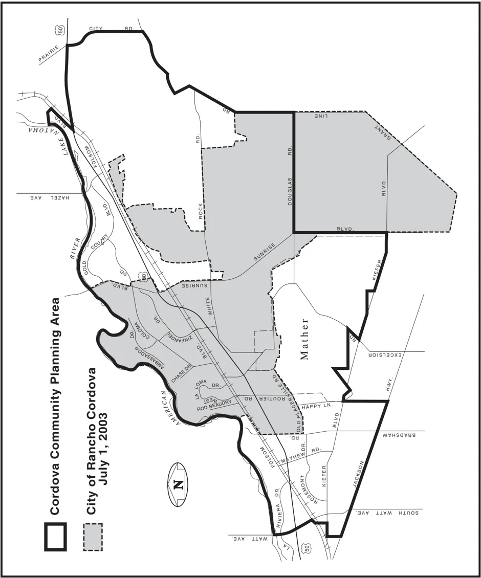
The Cordova community is rich in history. In the mid-1800s, an early route from Sacramento for miners in search of gold in the Sierra Nevada foothills was established along the present alignment of Folsom Boulevard. This was also the route for the Pony Express. Several ‘way stations’ or hotels sprang up along this route, and were used by the Pony Express riders as remounting stations. Many of these way stations were named after proprietors, or were indicative of their distance from Sacramento (e.g., ‘15 Mile House’). Perhaps the most famous, and still standing, is Mills Station, which was built in the early 1900s, and has been used as a post office, grocery store, and library. Today, this structure is being restored by Regional Transit for use a community center at the LRT station located near Mather Field Road and Folsom Boulevard. Agriculture (vineyards and orchards) was the main industry in this area in the 1800s. Current maps and street names still reflect many of the names of the early settlers of this area (e.g., Shields, Studarus, Kilgore, Deterding, Mendonca, and Mayhew). Kilgore Cemetery located on Kilgore Road, south of Folsom Boulevard, is the final resting-place and is also a memorial to many of these early settlers.
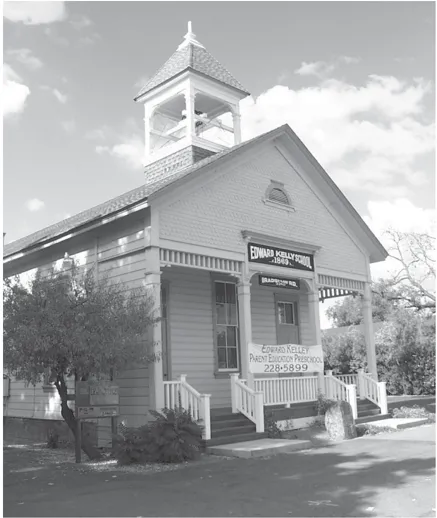
Historic Edward Kelly School located on Bradshaw Road, just south of Highway 50.
In the early 1900s, much of the Cordova area was subject to gold dredging operations, particularly that land located near the American River. There is still evidence of the tailing remains today in areas of the Gold River and Sunriver neighborhoods.
The predecessor to Rancho Cordova, the community of Mills, was well known for the quality of its produce, including grapes and other fruits. However, many years of drought and increasing property taxes lead to financial hardships for many local farmers; and by the mid-1950’s, both farmers and property owners were considering other alternatives. In response to increasing housing pressures attributable to the cold war escalation and employment growth at Mather Air Force Base and Aerojet, the first major housing development in this community was constructed just north of the intersection of Folsom Boulevard and Zinfandel Drive. The name of this subdivision, ‘Rancho Cordova’, can be traced to one of the early founders, Roland Federspiel, and his renowned vineyards. Popular radio and television personality Art Linkletter presided over the opening ceremony of the model homes.
The Mather area (the area defined by the former Air Force Base) was established as an airfield and pilot training school in 1918, and was named for Carl Mather, a World War I test pilot. In 1958, the Strategic Air Command B-52 squadron was assigned to Mather. The Air Force continued to use the facility throughout the years for military pilot and navigator training. In 1988, the Federal government formally announced the closure of Mather. The Mather aviation facilities (approximately 2,900 acres) were subsequently transitioned over to the County of Sacramento. In 1995, Mather was officially reopened as a civilian airport. Currently, air cargo carriers such as UPS, Airborne Express, and Emery operate at the facility; and air cargo volumes are one-half or greater than that occurring at the Sacramento International Airport. Approximately 800 acres were also transitioned to private enterprises such as McCuen Properties, and together with other developers, they are in the process of developing approximately 1 million square feet of commercial office development known as the Mather Commerce Center. Kaufman & Broad was selected to redevelop the original Base Housing, and is in the progress of developing a 1,270-unit single-family project known as Independence at Mather.
GenCorp Inc., parent company of Aerojet, is the region’s largest corporate land owner with approximately 13,000 acres bounded by the Folsom South Canal and Sunrise Boulevard on the west; Folsom Boulevard on the north; Prairie City Road, White Rock Road and Grant Line Road on the east; and Douglas Road on the south. This research and development company (previously controlled by General Tire and Rubber) got its start in 1942 with the formation of the Aerojet Engineering Corporation in southern California. Its first product was a small rocket motor (JATO) designed to provide an extra boost for aircraft using short runways such as carrier decks. Over the ensuing years, the company expanded to the defense and space exploration industry. Their core products were rocket propulsion-both solid and liquid; which were used in the Titan, Minuteman, and Polaris rocket systems. They were also instrumental in the development of infrared and microwave technology for use in satellite sensing systems. Perhaps they are most well known for developing an Orbital Maneuvering System (OMS) that is used for the Space Shuttle. In the early 1950s, in a need for more space, the company acquired the Sacramento facility, and employment grew to approximately 25,000. With defense cutbacks and increased competition for defense contracts beginning in the late-1960s, the company sharply reduced its workforce. Today the company is exploring diversification into other venues.
1.3 SACOG POPULATION PROJECTIONS
Section titled “1.3 SACOG POPULATION PROJECTIONS”As of this writing, information on housing, employment and population from the Census 2000 is just starting to be made available. SACOG representatives have indicated that employment data will not be released until 2003, and projections based on the 2000 Census will not be available until 2004. Growth projections based on the 1990 Census are developed through a joint effort between SACOG and local planning departments, and are available on the SACOG Web site. This projection data is available by minor zones (small geographic areas), census tracts, and cities or regional analysis districts (RADs). In the case of the Cordova planning area, the ‘Rancho Cordova’ RAD corresponds to the community plan boundaries. The 2000 Census uses a new geographic reference, known as the Census Designated Place (CDP), and identifies separate CDPs for Rancho Cordova, Rosemont, La Riviera and Gold River (see Exhibit 7.1.1).
According to the Census 2000 population profile for the Cordova planning area (see Table 7.1.1), there are a total of 96,260 persons residing within the planning area. The median age of this population is slightly lower than other jurisdictions in this area, which is reflective in the numbers of those under 18 years of age and those 65 years and above.
Using the 1990 Census information and 2000 as the base year, SACOG projects that housing within the Rancho Cordova RAD will increase from 37,757 dwellings to 41,100 (9%) by 2010, and to 54,148 (43%) by 2020. Population within the RAD is projected to increase from 96,099 to 104,868 (9%) by 2010, and to 136,284 (42%) by 2020. And finally, employment within the RAD is projected to increase from 87,093 to 107,557 (23%) by 2010, and to 125,954 (45%) by 2020. The increase in these numbers is largely attributable to new development that would occur on lands east of Sunrise Boulevard and south of Highway 50. See the Chapter 4 (Land Use) and Chapter 7 (Housing) for additional statistics.
1.4 OPPORTUNITIES
Section titled “1.4 OPPORTUNITIES”There are many challenges to this planning process; but on the other hand, challenges can often be viewed as opportunities. Several changes have occurred within this community planning area since the original plan was adopted in 1978. The most recent change has been the decision by the voters to incorporate Rancho Cordova, a geographic area roughly one-half of the community planning area, and located central to the planning area. Other changes have been the downsizing of Aerojet, and the conversion of Mather from a military facility to a civilian/air cargo facility. These two changes have resulted in an increase in the number of retirees in the community, and an aging commercial and residential housing stock. The third major change has been the evolution of new industries that have created a ‘regional employment center’ that includes new business parks south of Highway 50 (e.g., the Prospect Business Park and the Capital Center Business Park), large state offices (e.g., the Franchise Tax Board on Folsom Boulevard), and a hospitality industry consisting of approximately 25 hotels along the Highway 50 Corridor. These business centers currently have an employment base of approximately 65,000. Unfortunately, the housing stock has not been able to keep pace, and this has led to a tremendous increase in commute traffic. This commuter traffic has also been worsened as development pressures move further from the central business district and suburbs, and into foothill areas such as Granite Bay, Rocklin and El Dorado Hills.
This community planning area is, by design, a lineal community divided by a major freeway. Most of the housing is located on the north side of the freeway, while most of the employment is located on the south side. Folsom Boulevard which is one of the major commercial corridors serving this community runs parallel to this freeway, and also has a railroad corridor on its south side which limits access for those properties on the south side of this street. Extension of the LRT tracks will further constrain this access with the construction of a sound wall along the rear of residential neighborhoods that back-up to the tracks, as well as closure of some of those streets or driveways connecting with Folsom Boulevard. The American River along the northern boundary of the community, and the limited access (river crossings) to neighborhoods north of the river, creates impediments to vehicle and pedestrian access as well.
There are jurisdictional, social and economic boundaries within this community. The Sacramento City limits adjoin the western community plan boundary, while the Folsom City limits adjoin the eastern community plan boundary. Three water districts serve the community planning area: the Arden Cordova Water District, Citizens Utilities, and the Sacramento County Water Maintenance District. Four school districts serve the community planning area: the Folsom Cordova Unified School District, Sacramento City Unified School District, San Juan Unified School District, and the Elk Grove Unified School District. These jurisdictional boundaries have contributed to some neighborhoods aligning more closely with adjacent communities or incorporated areas. Socio-economic diversity is also prevalent in many of the neighborhoods within this community planning area; although, that data is not expected until release of the Census 2000 tabulation.
It is expected that this community plan will be adopted prior to July 1, 2003, when the Rancho Cordova incorporation officially takes effect. Even though there will be additional jurisdictional boundaries with the new city, both jurisdictions will be able to coordinate on common strategies set forth in this planning document, particularly those pertaining to Folsom Boulevard.
1.5 ASSUMPTIONS
Section titled “1.5 ASSUMPTIONS”Several assumptions can be made in the context of this community plan update. These assumptions are based on regional and local trends, and tied to verifiable data, as well as statistics provided in articles by the Sacramento Bee , Sacramento Business Journal and the Grapevine Independent.
1.5.1 Increase in Population
Section titled “1.5.1 Increase in Population”SACOG projects that the population within the community planning area will increase from 96,099 in the year 2000 to 104,868 (9%) by 2010, and to 136,284 (42%) by 2020. During this period, it is foreseeable that projects such as Villages of Zinfandel (2,300 dwelling units) and Independence at Mather (1,270 dwelling units) will build-out, and be the contributing factor for this increase in population within the planning area. Also during this period, SACOG projects that Roseville, Folsom and El Dorado Hills will outpace the community planning area in terms of net gain in housing units.
1.5.2 Increase in Employment
Section titled “1.5.2 Increase in Employment”SACOG projects that the employment within the planning area will increase from 87,093 in the year 2000 to 107,557 (23%) by 2010, and to 125,954 (45%) by 2020. According to articles in the Sacramento Business Journal and the Grapevine Independent , employment (office workers) within the business parks along the Highway 50 Corridor is, as of this writing, about 42,000, and is projected to increase to 95,000 (46%) by 2020.
1.5.3 Increased Traffic and Commute Times
Section titled “1.5.3 Increased Traffic and Commute Times”SACOG projects that adjacent bedroom communities such as Folsom and El Dorado Hills will outpace the community planning area in terms of net gain in housing units. This will equate to more commute traffic on Highway 50. SACOG has also conducted recent studies that show that approximately 50% of the total employment within the community planning area does not reside within this planning area. According to articles in the Sacramento Business Journal , traffic counts on Highway 50 have increased from an average of 44,300 cars in both directions in 1990 to about 51,000 (15%) a day in 1999, and will continue to increase at a rapid pace. The extension of LRT, expansion of bus routes, and the addition of carpool/HOV lanes to Highway 50 may help slow the rise in traffic levels and commute times.
1.5.4 New Housing
Section titled “1.5.4 New Housing”Within the term of this planning period, it is assumed that new residential project such as Village of Zinfandel and Independence at Mather will build-out, and provide an additional 3,600 dwelling units within the community planning area. The proximity of this new housing to employment, particularly to the business parks along the Highway 50 Corridor, will reduce some of the traffic and air quality impacts associated with this new development by helping to balance the jobs-housing equation. This new housing will also provide for ‘move-up’ opportunities for existing residents and satisfy a demand for a more specialized housing product that may appeal to ‘executives’ within the business parks.
1.5.5 Continued Dominance in Regional Office Construction
Section titled “1.5.5 Continued Dominance in Regional Office Construction”According to articles in the Grapevine Independent , in the third quarter of 2001, 0.5 million square feet of office space is under construction in the Highway 50 Corridor (i.e., the portion of the Highway 50 Corridor from 65 th Street to Hazel Avenue). In all, there is 10.7 million square feet of office space in the Highway 50 Corridor; the largest office market in the region, if government-owned buildings are excluded. Downtown Sacramento is second in the region with 8.8 million, again if government-owned buildings are excluded. It also noted that in this third quarter of 2001, vacancy rates are in the healthy range and vary between 9-10.7 percent. The low vacancy rate noted was Downtown Sacramento at 5.6 percent, and the high was West Sacramento at 40.7 percent. McCuen Properties and others are, as of this writing, in process of constructing an additional 1 million square feet of office space in the Mather Commerce Center.
1.5.6 Enhancement in the Appearance and Character of Folsom Boulevard
Section titled “1.5.6 Enhancement in the Appearance and Character of Folsom Boulevard”Folsom Boulevard is in a state of transition due to several factors. By the end of the term of this planning period, the boulevard should take on a whole new appearance and character. The extension of LRT from Mather Field Road to the City of Folsom will occur in the next few years and include 11 miles of track, 9 new stations, and more than 1,000 parking spaces. The new LRT stations will create opportunities for new development and transit linkages, better access to community services, and an alternative to vehicular commutes. Efforts of the Rancho Cordova Chamber of Commerce, and in particular its subcommittee for the Cordova Commercial Revitalization Project, have been very successful in promoting various improvements such as an ongoing facade improvement program (currently administered by SHRA) for businesses along the corridor, a pending landscaped median project (to be funded by the County Transportation) for the boulevard between La Loma Road and Sunrise Boulevard, a pending pedestrian-safety project (jointly funded by RT, County Transportation and SHRA) in the vicinity of the Mather Field/Mills LRT station, and in the formation of a Property and Business Improvement District (PBID) for property owners between Coloma Road and McGregor Road. In addition, new development along the boulevard such as the recently constructed Wal-Mart/Safeway project located at Zinfandel Drive and Folsom Boulevard will help promote redevelopment.
1.5.7 Mather Airport will Develop as a Premiere Air-Cargo Facility
Section titled “1.5.7 Mather Airport will Develop as a Premiere Air-Cargo Facility”Business at the airport is increasing at a phenomenal rate. Approximately 167,000 tons of air cargo was shipped through the airport in 2000, a 72 percent increase over 1999. Mather itself is home to nearly 20 businesses, including major air cargo carriers such as UPS, Airborne Express, and Emery. Many local companies such as Intel, Apple Computer, and Siemas Duewag use the airport as ‘home base’ for their fleets of executive jets. Annually, the airport is responsible for more than 1,300 jobs, which in turn generate more than $52 million in additional revenue throughout the Sacramento region. Further, the airport generates over $143 million in business revenue, and more than $7 million in state and local taxes. Clearly, Mather complex is an economic engine for this community, as well as for the region. It should be noted that, at the time of this writing, the Airport System Policy Plan is being updated, and a decision reaffirming the future of Mather Airport as a premiere air-cargo facility is assumed.
1.5.8 GenCorp (Aerojet) will continue groundwater clean-up efforts and seek development entitlements on a portion of its 13,000 acres.
Section titled “1.5.8 GenCorp (Aerojet) will continue groundwater clean-up efforts and seek development entitlements on a portion of its 13,000 acres.”The EPA has recently approved a $111 million plan for containing and remediation contaminated groundwater. The clean-up process involves the installation of a line of extraction wells at the outer perimeter of the containment plume under Rancho Cordova. The contaminated water will be pulled from the ground and treated as many as 6 times before being released from the aquifer. The EPA estimates that this treatment process could take up to 240 years. GenCorp representatives have noted that the EPA estimate does not account for new technologies that are under development by the company, and these new technologies show significant promise of greatly accelerating the clean-up process. However, it is likely that the clean up will disrupt traffic and affect quality of life of this community with the construction and installation of the necessary treatment wells and associated underground pipes.
A development proposal has been submitted for about 3,850 acres located on the western portion of the Aerojet property, between Douglas Road and White Rock Road. This project known as Rio Del Oro is predominantly residential, and may ultimately contain as many as 15,000 dwellings. A portion of that development proposal (1,100 acres) has since been purchased by Elliott Homes, and as of this writing, there are efforts underway to convert a portion of the application to 2,000 dwellings, and negotiate for the purchase of the remainder of the property subject to the original development proposal. Regardless of the ownership, the Rio Del Oro development is still in the early planning stages, and it may be years before it is approved. The availability of a safe potable water source is the primary issue. An article in the Sacramento Business Journal indicates that GenCorp will also pursue entitlements on 3,200 acres, along the Highway 50 Corridor, for a large office park. That portion of the property was recently certified by the EPA to be free from surface soil contamination.
1.5.9 The County of Sacramento and City of Rancho Cordova will Work Together to Implement Community Plan Strategies.
Section titled “1.5.9 The County of Sacramento and City of Rancho Cordova will Work Together to Implement Community Plan Strategies.”The community plan update was undertaken on the basis of the entirety of the planning area, without acknowledgment or anticipation of any new jurisdictional boundaries. Once the Rancho Cordova incorporation officially takes effect, there will be areas outside of the new city boundaries such as Gold River and Rosemont that will be regulated by this planning document. It is assumed that there will not be any significant land use changes imposed by a new city during the planning period, and it is believed that a term of 10 years is reasonable to help ensure that the assumptions of the plan are still valid. The benefit to the Cordova Community Plan is that both jurisdictions will be able to coordinate on common strategies set forth in the plan, particularly those pertaining to Folsom Boulevard. In the case of Folsom Boulevard, consistency will be paramount as portions of this street will remain in the unincorporated area, much like Stockton Boulevard in South Sacramento, and several new LRT stations are proposed to be located near the city boundaries. In addition, the plan can provide a greater sense of unity for neighborhoods, many of which are already divided by school districts or major arterials.
2.0 PLAN PRINCIPLES, GOALS, AND OBJECTIVES
Section titled “2.0 PLAN PRINCIPLES, GOALS, AND OBJECTIVES”OVERVIEW
Section titled “OVERVIEW”This chapter presents the vision, planning principles, goals, objectives and implementation actions that will help provide guidance to developers, service providers, planners, and decisionmakers in planning for both new development and the redevelopment of existing land uses within the community planning area. These ‘statements of intent and purpose’ shall also provide focus and guidance for future and more detailed planning efforts such as those associated with the formation of neighborhood action plans and streetscape master plans for Folsom Boulevard.
The vision statement is intended to provide a broad ‘picture’ of how the community would like to see itself evolve over the term of the planning period. The planning principles and themes provide further insight into the overall vision, and are grouped into three general categoriesCommunity Identity, Traffic Congestion Management, and Revitalization. The goals, objectives and implementation actions provide more specificity and guidance for developers, service providers, planners, and decision-makers in those areas of:
- Community Identity
- Land Use
- Urban Design and Neighborhood Character
- Transportation and Circulation
- Housing
- Recreation - Open Space
- Public Service Providers and Public Facilities
- Social Services
- Education
2.1 VISION STATEMENT
Section titled “2.1 VISION STATEMENT”This plan aims to achieve a high quality of life for all residents and employees, young and old, of the community described by the Cordova Community Plan by building on its rich history and proud heritage, active citizenry and the multi-disciplinary work of community-based interest groups, social and economic diversity, industry, recreational amenities, and its relation to surrounding communities. The goals and objectives outlined herein have been developed by the community, for the community, and are intended to provide a ‘vision of the future’ for the timeframe referenced by this plan. Sacramento County will take an active role promoting the objectives described herein, and will work hand-in-hand with community-based organizations to achieve common goals, and provide superior levels of service for its citizenry. The success of this vision will be measured by improved quality of life, including, but not limited to economic, employment, educational, cultural and environmental conditions for residents and employees of this community in relation to surrounding communities, and to the Sacramento region as compared to those conditions that have historically occurred within this community.
2.2 PLANNING PRINCIPLES AND THEMES
Section titled “2.2 PLANNING PRINCIPLES AND THEMES”In view of the changes that have occurred within the Cordova community planning area over the years, there is obviously a need to refocus many of the strategies outlined in the 1978 community plan. Over the course of the planning process, several common themes emerged that best reflect the vision for the area during the defined planning term. These themes capture both the unique character of the opportunities and challenges presented by factors such as the transformation of Mather from a US Air Force Base to a premiere business center and air-cargo facility, the extension of LRT and associated (new) stations, and the spirit of the community’s vision. A common thread runs throughout all of the various elements; and in many cases, land use decisions (e.g., decisions pertaining to LRT stations and their relation to adjacent uses) will likely cross over and bind all of the identified themes. These themes are outlined as follows:
2.2.1 Community Identity
Section titled “2.2.1 Community Identity”A positive identity is a very important concern for this community. The general layout of land uses within this community and the split that is created by the freeway, diversity of its many neighborhoods, and jurisdictional and socio-economic boundaries create obstacles to establishing a common identity. There are, however, many features or community assets that could be promoted in a positive manner. There are also numerous opportunities, which if properly managed, could create a positive identity for this community planning area as well. Community-based interest groups such as the Rancho Cordova Chamber of Commerce, and Cordova Community Council have been very successful in promoting a positive image for the community.
2.2.2 Traffic Congestion Management
Section titled “2.2.2 Traffic Congestion Management”The increase in traffic is also an important concern for this community. As noted above, the increase in jobs within this regional employment center and housing in adjacent bedroom communities such as Folsom and El Dorado Hills is expected to result in a continual degradation of traffic and air quality for the community planning area. These are impacts that are well beyond the scope of this plan, and it is recognized that the solution to the problem must be addressed on a regional scale. During this writing, SACOG is analyzing several possible regional solutions, and it is conceivable that a regional strategy will be adopted during the planning period. However, there are several opportunities within the context of this update to address the traffic issues locally, and contribute to the larger areawide solution. Some of these efforts pertain to providing for LRT linkage opportunities around each of the new LRT stations, redesigning commercial uses along Folsom Boulevard to be more pedestrian-friendly, providing for a better balance to the jobs-housing ratio, and encouraging linkages between manufacturing/distribution and the aircargo industry at Mather.
2.2.3 Revitalization
Section titled “2.2.3 Revitalization”Revitalization and enhancement in the physical appearance of existing commercial areas and residential neighborhoods is also an important issue with this community. Many residents view the number of multi-family developments and/or methods in which they are maintained to be a precursor to other community problems. For many years, there has not been any new housing development within this planning area. Employees seeking housing and residents interested in ‘move-up’ housing have had to look to other communities for these opportunities. Folsom Boulevard has failed to attract the necessary customer base to support many of the businesses along this corridor. The aging commercial and residential housing stock reflects pockets of blight and decay. Many factors are working to reverse this trend, and this plan will lend support to those efforts, and encourage new programs that will create an on-going state of ‘revitalization’ for the planning area.
2.3 GOALS AND OBJECTIVES
Section titled “2.3 GOALS AND OBJECTIVES”2.3.1 Community Identity
Section titled “2.3.1 Community Identity”Goal: Promote, both internally and externally, a positive image of the area described by the Cordova Community Plan, recognizing the diversity of its neighborhoods, businesses and citizenry.
Objectives:
Section titled “Objectives:”-
CID-1: Accentuate the positive in all media affecting the community whenever possible, and minimize the negative.
-
CID-2: Respond to negative media articles swiftly and with positive information-respond with a letter writing campaign by the community.
-
CID-3: Promote activities and special events within the community through newsletters and other publications.
-
CID-4: Support the concept of a central contact or coordinator for all media releases pertain- ing to the community.
-
CID-5: Promote festivals, parades and other community events that generate excitement and promote a wholesome family image for the community.
-
CID-6: Encourage close coordination with the hospitality industry and various business interests to identify common strategies to promote a positive community identity.
-
CID-7: Encourage participation in regional decision-making by community residents.
-
CID-8: Encourage the use of history (e.g., the Pony Express) in community promotional publications.
-
CID-9: Promote events that cross neighborhood and cultural boundaries.
-
CID-10: Promote a ‘network’ (e.g., the Cordova Community Council) with schools, churches and other public institutions.
Implementation Actions:
Section titled “Implementation Actions:”- Sacramento County shall designate an individual (either through the County Executive’s Office or the Department of Planning and Community Development) to work closely with various community/business organizations and neighborhoods in the promotion of matters pertaining to community identity.
- Implement a Special Planning Area, or similar mechanism, for the Folsom Boulevard Corridor that supports the revitalization of businesses and neighborhoods along the boulevard.
- Work closely with the hospitality industry and various business interests; in particular, the Rancho Cordova Chamber of Commerce, to develop common strategies to promote a positive community identity.
- Work closely with neighborhoods, and provide an ongoing program to identify solutions to residents concerns.
- Work closely with the Sacramento Housing and Redevelopment Agency and Sheriff to resolve matters pertaining to crime, particularly crime that occurs in or around multifamily housing complexes.
- Discourage additional billboard signage along Highway 50. In the event that additional billboards are deemed appropriate, do not allow deviations (variances) from existing sign standards, and the removal of existing trees or vegetation. Consider the aesthetics of such proposals (e.g., Does the sign alter vistas, block significant architecture, and other assets that this community has to offer?), safety hazards (distractions) for travelers on the freeway, and any Caltrans concerns.
- Support community events (e.g., Eppie’s Great Race and the Nimbus Salmon Festival) that cross community/neighborhood boundaries, and help bring together various segments of the population.
- Work with Caltrans and County Transportation to include roadway beautification measures (e.g., interchange landscaping, median landscaping and sound wall repair/replacement) as components of all roadway improvement projects.
- Promote the formation of new community organizations (e.g., garden and historical society) that will sponsor, maintain, and provide tours of planning area amenities.
2.3.2 Land Use
Section titled “2.3.2 Land Use”Goal: Create an orderly, balanced, and integrated land use pattern that emphasizes revitalization of existing land uses; supports the diversity of business, particularly the transformation of Mather as a premiere business center and air-cargo facility; promotes a pedestrian-friendly, multi-modal environment that capitalizes on the linkage opportunities of the LRT stations; and enhances the regional and local character, identity, and quality of development.
Objectives:
Section titled “Objectives:”-
LU-1: Improve the character and quality of existing development through the revitalization of blighted and underutilized development.
-
LU-2: Emphasize high technology industry, business park uses, and industries such as manufacturing and distribution that provide support for Mather air-cargo operations.
-
LU-3: Promote a balance between the growth of the air-cargo industry at Mather with the need for housing and residential lifestyles in adjacent neighborhoods.
-
LU-4: Promote linkages between LRT station and adjacent land uses, particularly within a 1/4mile radius of the LRT station.
-
LU-5: Promote mixed-use concepts that capitalize on synergies between and among different types of land use (e.g., residential and office).
-
LU-6: Promote high quality, efficient and cohesive land utilization that minimizes negative impacts on adjacent neighborhoods and infrastructure (e.g., traffic congestion and visual blight).
-
LU-7: Coordinate with GenCorp on the commercial, office, and residential development of their property; and ensure integration of that development into the community.
-
LU-8: Continue the tradition of joint development of parks and schools.
-
LU-9: Promote a ‘town center’ concept for Folsom Boulevard where a variety of mixed-use, civic, retail and recreation/open space uses can be developed.
-
LU-10: Recognize the diversity of the population (based on age, culture and economic status) within the community planning boundaries, and plan land uses according to the needs of this population.
Implementation Actions:
Section titled “Implementation Actions:”- Implement a Special Planning Area, or similar mechanism, for the Folsom Boulevard Corridor that supports the revitalization of businesses and neighborhoods along the boulevard.
- Utilize GIS-based modeling programs such as INDEX in the evaluation of various land use proposals, particularly those adjacent to LRT stations, and alternative courses of action in the project analysis and recommendations.
- Work with neighborhoods to coordinate ‘infill’ planning efforts with community development/revitalization goals, and ensure that these future land uses will complement existing development.
- Identify areas where high technology industry, business park uses, and industries such as manufacturing and distribution that provide support for Mather air-cargo operations and need close proximity to the airport can locate; and support the development of such uses.
- Carefully evaluate the relation of land uses, particularly residential uses, in relation to Mather Airport, and the impacts to the growth of the air-cargo industry, and weigh those impacts against the need for additional housing in the community.
- Develop an incentive package to provide financial incentives to encourage linkages between LRT station and adjacent land uses, particularly within a 1/4-mile radius of the LRT station.
- Work closely with GenCorp in the initial development of land use concepts for their property to ensure that eventual development will be integrated into the community, recognize the area-wide circulation problems, and capitalize on the opportunities for a pedestrian-oriented, mixed-use, multi-modal transportation environment presented by the new LRT station at Aerojet Road.
2.3.3 Urban Design and Neighborhood Character
Section titled “2.3.3 Urban Design and Neighborhood Character”Goal: Create a safe, attractive, and vibrant urban environment for all residents, employees, and customers/patrons of businesses within the community planning area.
Objectives:
Section titled “Objectives:”-
UDNC-1: Provide for commercial districts in new neighborhoods that are integrated into and physically connect with those adjacent neighborhoods.
-
UDNC-2: Encourage architecture and building design that promotes pedestrian and other multi-model forms of access.
-
UDNC-3: Promote the revitalization of older commercial areas in order to provide better pedestrian connections and increase availability of services to adjacent neighbor- hoods.
-
UDNC-4: Promote neighborhoods that are reflective of a diverse population, and are competi- tive with other communities in the region in terms of their value and desirability.
-
UDNC-5: Ensure that new development reflects local history and architecture, neighborhood concerns, and incorporates features that will help integrate the development into the fabric of the community.
-
DNC-6: Promote the installation of landscaped medians and meandering or separated sidewalks to create a more attractive and active streetscape environment, particu- larly along the Folsom Boulevard Corridor.
-
UDNC-7: Encourage the formation of distinct but integrated commercial districts with appro- priate focal points, core activity areas, and supporting amenities.
-
UDNC-8: Promote high quality architecture, landscape, and streetscape features that enhance the character and identity of activity areas.
-
UDNC-9: Promote pedestrian-friendly, human-scale urban environments that provide safe and pleasant places for people to live and work.
-
UDNC-10: Encourage infill development and redevelopment to strengthen and improve the character of existing development as a means to avoid sprawl in other areas, provide greater connectivity by means of circulation improvements, and to complement and complete existing neighborhoods.
-
UDNC-11: Ensure that potentially incompatible and unsafe land uses are separated from residential uses by appropriate transition areas.
-
UDNC-12: Encourage screening of visibly large or tall structures such as water tanks or cellular facilities, by either locating them in areas seen by few people or ‘hidden’ such as with the placement on the roof of a building or integration into the building’s design and architecture.
-
UDNC-13: Promote the undergrounding of all electrical utilities.
Implementation Actions:
Section titled “Implementation Actions:”- Develop urban design and architectural guidelines that encourage pedestrian-friendly and human-scale development.
- Appoint a local entity (e.g., CORPAC) as the review authority for all building permits for development along the Folsom Boulevard Corridor.
- Implement a Special Planning Area, or similar mechanism, for the Folsom Boulevard Corridor that provides guidelines for architecture, signs, and transit-supportive development; and local design review of all development along the boulevard.
- Support the County’s beautification project for Folsom Boulevard, and encourage similar improvements to Coloma Road, Sunrise Boulevard, and Mather Field Road.
- Work with RT and landowners to develop a central plaza at the Mather Field/Mills LRT Station where community events could be staged.
- Work closely with neighborhoods, and provide assistance through the Sheriff, Code Enforcement, SHRA, and other programs such as the Cordova Community Area Service Team to improve dilapidated properties and enhance public safety.
- Provide assistance for neighborhood organizations through the Sheriff and programs such as the Cordova Community Area Service Team in the formation of homeowners associations and Neighborhood Watch programs.
- Promote the formation of new neighborhood organizations through programs such as Neighborhood Link and the Cordova Community Area Service Team in the formation of Web sites to share information such as meeting minutes, announce neighborhood events, and highlight amenities of the community.
- Require that all applicants for cellular facilities submit appropriate justification for single ‘stand alone’ facilities, and demonstrate through coverage statistics why such facilities cannot be relocated to a less visible site, or modified in design (e.g., modified to resemble a flag pole or tree) to be less apparent.
- Promote the elimination of barriers (e.g., power poles and electrical transformers) and installation of separated sidewalks to create a more attractive and active pedestrian streetscape environment, particularly adjacent to the LRT stations.
- Use various incentives to promote reuse of property adjacent to the LRT stations.
- Encourage build-out of vacant and underutilized property adjacent to the LRT stations.
- Support the establishment of suitable support services (e.g., day care facilities, dry cleaners, and restaurants) for employment centers to reduce the number of necessary vehicle trips.
- Work with financial institutions and state and local housing agencies to reduce the time repossessions and foreclosures are held, and explore market rehab loan programs and first-time buyer assistance programs.
2.3.4 Transportation and Circulation
Section titled “2.3.4 Transportation and Circulation”Goal: Provide for the safe, convenient, and efficient movement of people to and through the community using various forms of transportation (of equal importance); including, but not limited to, personal vehicles, buses, LRT, bicycles, and walking, while minimizing adverse impacts to neighborhoods.
Objectives:
Section titled “Objectives:”-
TC-1: Promote a high quality multi-modal transportation system by reducing mobile-source emissions and reliance on the personal automobile.
-
TC-2: Encourage roadway circulation improvements that minimize congestion, provide for alternative forms of transportation (e.g., bicycles, golf carts and guided-buses), maximize efficiency and convenience, promote safety, and are sensitive to surrounding neighborhoods.
-
TC-3: Focus truck traffic on designated arterial roadways to minimize impacts to residential neighborhoods and business parks.
-
TC-4: Encourage linkages between LRT stations and adjacent land uses, particularly within a 1/4-mile radius of the LRT station, and encourage the design of employment centers to be convenient for walk-on patrons of LRT.
-
TC-5: Promote public transit services to all employment and activity centers; or alternatively, encourage the formation of privately funded shuttle bus services within the community.
-
TC-6: Promote the location of convenient LRT stations to provide access for all segments of the population to a broad range of neighborhoods, employment centers, retail and community services.
-
TC-7: Promote a high quality off-street bicycle/pedestrian system that connects all major employment and activity centers.
-
TC-8: Ensure adequate pedestrian circulation by sidewalks or similar means within and between land uses.
-
TC-9: Ensure adequate bicycle provisions within new land uses to encourage bicycle usage.
-
TC-10: Encourage membership in the local TMA (e.g., Highway 50 Corridor TMA) for all new development.
-
TC-11: Encourage the construction of a high-speed, limited-access expressway (parkway concept) linking Roseville-Rocklin with Folsom, Rancho Cordova and Elk Grove, and offering relief to the traffic congestion on the Highway 50 Corridor.
Implementation Actions:
Section titled “Implementation Actions:”- Work with the SMAQMD, the Highway 50 Corridor TMA, RT, and employers to develop Transportation Demand Management programs for all new development that includes, but is not limited to, the use of carpooling, flexible work hours, rental/sharing of company vehicles and bicycles, and telecommuting.
- Implement a Special Planning Area, or similar mechanism, for the Folsom Boulevard Corridor that encourages and provides incentives for transit-supportive development within a 1/4-mile radius of LRT stations; as well as a pedestrian-friendly, mixed-use, multi-modal environment along the boulevard.
- Explore new roadway connections within the community planning area that may help to improve area-wide circulation, and amend the General Plan Transportation Diagram accordingly.
- Work with the City of Sacramento, City of Folsom, SABA, and the Bicycle Task Force to identify new bicycle improvements within the community planning area, and amend the Bikeway Master Plan accordingly.
- Work with the Department of Parks, Recreation and Open Space to identify possible funding sources (e.g., a Mello Roos or County Service Area finance district) that would allow for the County to take possession and maintain the trail along the Folsom So. Canal as a public off-street bikeway.
- Amend the County Code to require Transportation Systems Management (TSM) Plans for all employers of 50 or more employees, achievable goals (e.g., a 35 percent reduction in vehicle trips) adequate enforcement mechanisms, and encourage membership in a local TMA (e.g., the Highway 50 Corridor TMA).
- Require adequate right-of-way dedication from new development to provide opportunities for multi-modal transportation, and explore policies that require initial construction of this right-of-way at the outer boundaries (future right-of-way line) so that a center median can be reserved for alternative forms of transportation, and interim planting with landscaping.
- Support a reduction in regulations for parking and/or building setbacks to encourage LRT walk-on patronage from adjacent land uses.
- Provide adequate transit and shuttle services and other linkages (e.g., pedestrian crossings of Highway 50) to encourage easy and convenient access for employees of the Highway 50 Business parks to existing commercial services along Folsom Boulevard.
- Provide appropriate signalization and pedestrian crossings within existing employment centers (e.g., the Highway 50 Business Parks) to ensure the smooth flow of traffic and at the same time provide for safe pedestrian mobility.
- Support a reduction in parking for office complexes that provide aggressive transportation reduction measures, and on-site employee support services.
- Identify a suitable transportation (truck) route from Highway 50 to Mather Airport that does not adversely impact adjacent residential neighborhoods or businesses, and improve the roadway system to accommodate truck traffic.
- Work with neighborhoods and the County Transportation Department to help identify solutions to help slow and/or discourage cut-through traffic in residential neighborhoods, and in a manner so as not to result in the diversion of that traffic to adjacent neighborhoods.
- Encourage RT to consider Bus Rapid Transit on the Sunrise Boulevard and Alta Sunrise corridors, and reserving necessary right-of-way for an additional LRT station at the future intersection of Alta Sunrise and Folsom Boulevard.
- Encourage and support the design of residential neighborhoods with a network of pedestrian/bicycle trails such as those provided within the Villages of Zinfandel and Gold River.
- Utilize GIS-based modeling programs such as INDEX in the evaluation of various land use proposals, particularly those adjacent to LRT stations, to improve the quality of pedestrian access to public transit, and within and between land uses.
- Promote joint-use and fewer driveways for smaller parcels in order to provide additional area for sidewalks.
- Work to identify funding for the construction of separated sidewalks on the south side of Folsom Boulevard.
- Promote and encourage the construction of separated sidewalks wherever possible.
- Eliminate barriers to pedestrian/bike access (e.g., utility poles, and fencing).
- Support the installation of signals at major intersections within the Highway 50 business parks to enhance pedestrian safety.
- Promote the formation of County Service Areas (CSAs) to help finance Transportation Demand Management programs.
2.3.5 Housing
Section titled “2.3.5 Housing”Goal: Develop an adequate supply of high-quality housing and residential neighborhoods to meet the jobs-housing balance, the growing senior population, and provide for move-up opportunities for all segments of the community’s population.
Objectives:
Section titled “Objectives:”-
H-1: Promote a balance for the jobs to housing ratio that will support the community position as a regional employment center.
-
H-2: Promote the development of strong and safe residential neighborhoods with convenient access to community and urban amenities including parks, public transit, schools, shopping, and other services.
-
H-3: Encourage opportunities for employees, particularly those employees within the Highway 50 Business Parks, to be offered an advance purchase opportunity for housing in new subdivisions.
-
H-4: Promote housing convenient to employment centers (e.g., as is the case with the proximity of Village of Zinfandel and its relation to the Highway 50 Business Park), and appropriate linkages for pedestrians and bicyclists.
-
H-5: Encourage the seamless integration of into neighborhoods with existing development, particularly in regard to circulation and sharing of neighborhood parks; and discourage the construction of ‘gated communities’.
-
H-6: Recognize the changes in population and culture, and promote housing based on the special needs of groups such as seniors and new immigrant populations.
-
H-7: Promote the revitalization of existing substandard housing within the community.
-
H-8: Encourage the addition of amenities such as pools, tot lots, recreation centers, and basketball courts to existing older multi-family developments within the community.
-
H-9: Ensure an adequate mix of housing affordability dispersed throughout the community.
-
H-10: Encourage a variety of lot sizes and housing types to promote social and economic diversity, and to provide greater variation visibly for neighborhoods.
-
H-11: Promote policies to cite duplexes for all corner lots in single-family subdivisions to promote a better integration of housing types throughout the community
Implementation Actions:
Section titled “Implementation Actions:”- Work with the Sacramento Housing and Redevelopment Agency, the Sacramento County Code Enforcement Section and Sheriff to identify programs to improve existing substandard housing, and create partnerships between these agencies to implement those programs.
- Work with homebuilders, the SMAQMD, and the Highway 50 Corridor TMA to explore programs whereby homebuilders would offer the opportunity for employees of nearby employment centers, particularly those employees within the Highway 50 Business Parks, advance purchase opportunities for housing in new subdivisions, employer subsidized ‘no points’ financing, and other incentives to encourage employees to relocate closer to their job site.
- Implement a Special Planning Area, or similar mechanism, for the Folsom Boulevard Corridor that encourages and provides incentives for various forms of residential and mixed-use development within a 1/4-mile radius of LRT stations.
- Work with the Sheriff and Fire Prevention District to ensure that appropriate safety, and crime and fire prevention measures are incorporated into all new residential developments.
- Establish policies and procedures to encourage the citing of duplexes for all corner lots in single-family subdivisions to promote a greater variation in housing types throughout the community.
- Work closely with GenCorp in the initial development of land use concepts for their property to ensure that eventual development will include an adequate mix of commercial, office and housing, with appropriate linkages to nearby and/or new employment centers.
- Identify ‘infill’ sites that could accommodate additional residential development, and provide incentives to prioritize development on those sites.
- Work with various social service providers to identify special housing needs for the planning area.
- Encourage the reuse of underutilized commercial property, particularly for mixed-use development.
- Work with financial institutions and state and local housing agencies to reduce the time repossessions and foreclosures are held, and explore market rehab loan programs and first-time buyer assistance programs.
- Work with the Sacramento Housing and Redevelopment Agency and the Sheriff to identify special needs of residents of existing multifamily complexes, particularly recreational amenities for children (e.g., basketball courts, day care, and computer access), and assist in the financing and citing of those amenities.
- Work with various human service providers, the Cordova Recreation and Park District, and developers to cite appropriate senior facilities/housing throughout the planning area.
2.3.6 Recreation - Open Space
Section titled “2.3.6 Recreation - Open Space”Goal: Continue the tradition of providing a diverse network of local and regional parks and recreation facilities to meet the needs of all segments of the community’s population.
Objectives:
Section titled “Objectives:”-
ROS-1: Promote a high quality network of parks and open space that provides a mix of passive and active recreational opportunities for community residents.
-
ROS-2: Ensure a balanced mix of passive and active recreation opportunities in open space areas, and promote the environmental sustainability of these resources.
-
ROS-3: Preserve and enhance mature landscaping (e.g., native oak trees) whenever possible.
-
ROS-4: Encourage the Cordova Recreation and Park District and local school districts (Folsom Cordova Unified, San Juan Unified, Sacramento City Unified, and Elk Grove Unified) to continue to enter joint-use agreements to provide for the use of school recreation facilities, including school grounds and classrooms; and support the creation of new agreements where none currently exist.
-
ROS-5: Ensure that new development provides appropriate pedestrian and bicycle linkages to existing facilities, particularly to those facilities within the American River Parkway.
-
ROS-6: Encourage developers to work closely with the Cordova Recreation and Park District in the identification and development of new park sites.
-
ROS-7: Protect and preserve sensitive environmental areas and wildlife habitats including wetlands, riparian corridors, annual grasslands, and floodplains; and encourage restoration and educational opportunities (e.g., public walkways and informational signage) for such areas when appropriate.
-
ROS-8: Ensure the proper management, maintenance, and sustainability of open space areas.
Implementation Actions:
Section titled “Implementation Actions:”- Work with the Department of Parks, Recreation and Open Space to identify possible funding sources (e.g., a Mello Roos or Community Service Area finance district) that would allow for the County to take possession and maintain the trail along the Folsom So. Canal as a public off-street bikeway.
- Work with the Cordova Recreation and Park District to identify possible funding sources (e.g., a Mello Roos, Landscaping and Lighting, or Community Service Area finance and assessment district) that would allow for addition maintenance of existing facilities, offset maintenance and operation costs of new facilities, and the installation of restrooms in all parks.
- Explore partnerships or joint-development opportunities between the Cordova Recreation and Park District and other service providers, whereby there could be joint-use of facilities as well as added supervision of park facilities.
- Work with the Cordova Recreation and Park District and various social service providers to identify new immigrant group leaders, the special recreational needs for these groups (e.g., community gardens), and possible funding sources that might be used to help finance these facilities.
- Support community events (e.g., Eppie’s Great Race, Fourth of July Celebration, Kid’s Day, and the Nimbus Salmon Festival) that cross community/neighborhood boundaries, and help bring together various segments of the population.
- Support the Cordova Recreation and Park District in their construction and maintenance of community pools, and explore the possibility for the District to construct a ‘yearround’ community pool.
- Support the expansion of the Cordova Senior Center at the Lincoln Village Community Park, and/or construction of new senior community facilities to meet an increasing demand for such facilities.
- Work with various human service providers and the Cordova Recreation and Park District to cite appropriate youth recreation facilities throughout the planning area.
- Support the update of the American River Parkway Plan, and encourage participation by all segments of the population, particularly youth, seniors and new immigrant group leaders, so that special recreational/open space needs for these groups can be identified and accommodated.
- Work with the various social service providers to identify new immigrant group leaders, the special recreational needs for these groups, and consider the addition of a multicultural facility to the Regional Park planned for Mather.
- Ensure that new development provides appropriate pedestrian and bicycle linkages to existing facilities, particularly to those facilities within the American River Parkway.
2.3.7 Public Service Providers and Public Facilities
Section titled “2.3.7 Public Service Providers and Public Facilities”Goal: High quality public services and public infrastructure to meet the needs of all residents and employees within the community.
Objectives:
Section titled “Objectives:”-
PS-1: Provide a well-planned sewer service with adequate capacity to serve the community, and accommodate new growth areas during the identified planning period.
-
PS-2: Provide a reliable, contaminant-free, long-term source of water to serve the community, which protects the groundwater aquifer(s) from long-term damage attributable to drawdown by the use of public/private wells.
-
PS-3: Provide adequate drainage and flood protection for all urbanized portions of the community.
-
PS-4: Provide and maintain a solid waste collection and disposal service for all areas of the community, while reducing the amount of solid waste generated within the community area through reduction and recycling.
-
PS-5: Provide adequate and affordable energy services and facilities for all areas of the community.
-
PS-6: Ensure the availability and accessibility of public services for all segments of the population.
-
PS-7: Promote the concept of coordinated development of a single site by multiple agencies (e.g., fire, libraries, schools and parks) to provide greater convenience for the public.
-
PS-8: Provide support for the Sacramento Metropolitan Fire District in the citing, remodeling, consolidation, and relocation of fire stations and fire prevention facilities due to their recent reorganization.
-
PS-9: Promote suitable fire protection/prevention measures for all developments.
-
PS-10: Ensure that all library sites are adequately served by public transit.
-
PS-11: Promote coordination between the Sheriff and RT in matters related to safety in public transit use.
-
PS-12: Encourage the concept of neighborhood policing, and the formation of ‘Neighborhood Watch’ programs.
-
PS-13: Promote a method or system for community communication for the Sheriff.
-
PS-14: Promote coordination between the Sheriff and local school districts.
-
PS-15: Encourage screening of visibly large or tall structures such as water tanks or cellular facilities, by either locating them in areas seen by few people or ‘hidden’ such as with the placement on the roof of a building or integration into the building’s design and architecture.
-
PS-16: Promote the undergrounding of all electrical utilities.
Implementation Actions:
Section titled “Implementation Actions:”- Work closely with neighborhoods to identify their needs for pubic services and infrastructure, and provide assistance through programs such as the Cordova Community Area Service Team to identify and achieve methods to meet these needs.
- Work with the Sheriff and Fire Prevention District to ensure that appropriate safety, and crime and fire prevention measures are incorporated into all new developments.
- Provide assistance to the Sheriff in the formation of ‘Neighborhood Watch’ programs.
- Support business-sponsored Sheriff patrol services such as Business Problem-Oriented Policing (POP) Officers and the ‘We Mean Business’ program.
- Work with the various service providers to identify locations where a coordinated development of a single site by multiple agencies could occur (e.g., in the case of the Rancho Cordova Neighborhood Center); and support and encourage the construction of such projects through rezones and priority application processing.
- Explore various funding sources to allow additional Sheriff patrol officers, a new civilian field position known as a Community Services Specialist II (CSS II), and Sheriff’s patrols for the American River Parkway bike trail and other open space areas within the Parkway.
- Explore the potential for ‘satellite library’ facilities, or joint facilities in conjunction with school libraries.
- Support long-range planning efforts for libraries to help identify how these facilities might better serve the community needs as they evolve over time.
- Work with various social service providers to identify special service needs.
2.3.8 Human Services
Section titled “2.3.8 Human Services”Goal: Support high quality human services that provide assistance through various forms so that individuals can become healthy (mentally and physically), achieve their highest potential, self-sufficiency, and a better quality of life for themselves and their dependants, and help contribute to a strong community.
Objectives:
Section titled “Objectives:”-
HS-1: Promote services that emphasize strong individual and family functioning.
-
HS-2: Promote the concept of a ‘One-Stop Shop’ or coordinated development of a single site by multiple social service providers to provide greater convenience for the public.
-
HS-3: Provide opportunities for expansion at all social service provider facilities to meet the growing needs of the community.
-
HS-4: Ensure that all social service provider facilities are adequately served by public transit.
-
HS-5: Encourage various age groups (e.g., teens and seniors) to be participants in the planning and providing of social services, and recognize/capitalize on the strengths and talents of each of these groups.
-
HS-6: Provide opportunities for neighborhoods to participate in decisions of where to locate social service uses.
-
HS-7: Encourage health care providers that accept Medi-Cal insurance to locate within the community, and improved access to health care services.
-
HS-8: Recognize the changes in population and culture, and promote social services based on the special needs of these groups (e.g., seniors and new immigrant populations).
-
HS-9: Promote partnerships between local churches, schools, non-profit groups, businesses and governmental agencies in the coordination of social services.
Implementation Actions:
Section titled “Implementation Actions:”- Coordinate with the various social service providers to identify locations where a ‘OneStop Shop’ or a coordinated development of a single site by multiple agencies could occur (e.g., in the case of the Rancho Cordova Neighborhood Center); and support and encourage the construction of such projects through rezones and priority application processing
- Work with various social service providers to identify new immigrant group leaders, and provide assistance to such groups to identify and achieve methods to meet their needs.
- Work closely with neighborhoods to identify their needs for social services and in decisions to locate or expand such facilities in the vicinity of their neighborhood.
- Support efforts by local businesses to train/retrain employees, sponsorships of educational programs, and internship programs through the local schools.
- Explore options to provide ‘grants’ to community-based, non-profit groups (e.g., the Family Support Services Center) for the purpose of supplementing the funding for ongoing programs.
- Provide for day care needs by implementing programs that involve a combination of volunteers, businesses, and governmental agencies.
- Support joint-use facilities whereby human services are located on school sites.
- Support the proposed expansion and remodel of the DHA facility located on Folsom Boulevard.
- Work with industry representatives to identify sites suitable for a full-service hospital, including 24-hour emergency room. As a general rule, these sites should be located in a campus-like setting, well served by major thoroughfares and public transit, and centrally located for patrons within the Cordova planning area.
2.3.9 Education
Section titled “2.3.9 Education”Goal: Support the highest quality education for children within the community, comparable or exceeding that provided in other areas in the region.
Objectives:
Section titled “Objectives:”-
ED-1: Promote the concept of schools as the center of community life.
-
ED-2: Encourage the Cordova Recreation and Park District and local school districts (Folsom Cordova Unified, San Juan Unified, Sacramento City Unified, and Elk Grove Unified) to continue to enter joint-use agreements to provide for the use of school recreation facilities, including school grounds and classrooms; and support the creation of new agreements where none currently exist.
-
ED-3: Promote and support late night and weekend community activities at schools.
-
ED-4: Promote neighborhood participation in school site planning of facilities, services and connectivity.
-
ED-5: Ensure adequate school facilities to serve newly developing areas.
-
ED-6: Promote programs by local businesses to sponsor educational programs (e.g., computer classes), and internships through the local schools.
-
ED-7: Support diverse curriculum in local schools to provide a broad range of education for students.
-
ED-8: Support the development of youth/recreation centers within school facilities.
-
ED-9: Identify and support new concepts for providing additional classroom facilities (portables) to accommodate growth, and alternatives to bussing students.
-
ED-10: Encourage efforts to identify new funding sources for school facilities.
Implementation Actions:
Section titled “Implementation Actions:”- Work with local school districts to locate appropriate school sites within newly developing areas.
- Use school facilities whenever possible for neighborhood meetings.
- Work with local school districts to identify sites suitable for joint-use school/human service uses.
- Assist the Folsom Cordova USD to provide and cite additional classroom facilities (portables) to accommodate the projected growth within the district over the term of their master plan.
- Explore the potential for ‘satellite library’ facilities, or joint facilities in conjunction with school libraries.
- Promote local programs such as TEAM 650 where community resources, business interests and parents are brought together to help motivate students, business sponsored educational programs (e.g., computer classes), and internships through local businessschool partnerships.
- Work with various human service providers to identify new immigrant group leaders, and provide educational and language programs to meet their needs.
3.0 COMMUNITY IDENTITY
Section titled “3.0 COMMUNITY IDENTITY”OVERVIEW
Section titled “OVERVIEW”A key element to the community planning effort is the promotion of a positive community identity, and to a certain extent, a positive community image. Identity is very important to this community, and can be influenced by actions taken on many of the other elements as well.
The general layout of this community in terms of land uses, and environmental/physical features (e.g., the split that is created by Highway 50, diversity of its many neighborhoods, and the jurisdictional and socio-economic boundaries) are problematic, and create challenges to establishing a common identity. There are, however, common features (e.g., Mather Airport, the American River Parkway, and the Highway 50 Business Parks) that could easily be promoted in a positive manner. There are also numerous opportunities, which if properly managed, could create a positive identity for this community planning area as well.
3.1 BRIDGE THE BOUNDARIES
Section titled “3.1 BRIDGE THE BOUNDARIES”The physical boundary that Highway 50 creates is one of the major obstacles in creating a common identity for this community. Several developments in the next few years will help to bridge that barrier. New residential development on the south side of the freeway will help balance the distribution of the residential population. The extension of LRT and changing nature of land uses along Folsom Boulevard will bring people to that corridor. The construction of a multicultural park at Mather will allow for sharing of the traditions and customs of a diverse population. Additional improvements to the roadway system will also help move people through the community. However, opportunities exist for improvements to pedestrian and bicycle circulation system. These improvements include additional crossings of Highway 50 and improvements to the Folsom South Canal, and will be discussed further in Chapter 6.
Existing neighborhoods, in many cases, foster the creation of their own boundaries, based on socio-economic or cultural diversity. This planning process attempted to bring together as many representatives from different segments of the population within the planning area as possible. It was not the intent of this exercise to discourage people to identify with a particular neighborhood, but rather to identify ways to bring them together and identify with a common theme or ‘community’. There are many events that occur within this community that help bring people together, and cross-neighborhood boundaries. Festivals, parades and other community events such as the Fourth of July Celebration at Hagan Park, Eppie’s Great Race, and the Nimbus Salmon Festival attract thousands of participants as well as spectators. These types of community events promote an identity, generate excitement, and a help create a positive image for the community.
3.1.1 Recommendations
Section titled “3.1.1 Recommendations”- Identify and construct improvements to the pedestrian and bicycle circulation system.
- Plan festivals, parades and other community events that appeal to diverse community interests, and in locations convenient and accessible by all community residents.
- Construct a community multi-cultural center, preferable at Mather, for various community events to occur.
- Identify new immigrant group leaders, and promote those cultural events in which all community residents may participate.
- Support community events (e.g., Eppie’s Great Race, Fourth of July Celebration, Kid’s Day, and the Nimbus Salmon Festival) that cross community/neighborhood boundaries, and help bring together various segments of the population.
3.2 PROMOTE THE POSITIVE
Section titled “3.2 PROMOTE THE POSITIVE”Much of the identity problems today relate to public perception, and the solutions are often as easy as ‘educating’ the various forms of media, emphasizing the positive in day-to-day dialog, or planting flowers to convey a more positive impression. Public relations professionals are often called upon to promote a positive identity, and in helping to coordinate various events that occur on a community-wide basis.
The Cordova community planning area has the advantage of having many community and neighborhood organizations that meet regularly to discuss and plan for various community events, and are involved in ongoing efforts to improve the overall quality of life for all community residents. These organizations also work to improve the community image as well. The Rancho Cordova Chamber of Commerce is an example of one such organization that is very successful in promoting the ‘positive’ in community affairs. A more active role by representatives of Sacramento County (e.g., attending the regular meetings of these organizations) might
help to supplement these various community efforts with governmental programs and/or funding, and help coordinate efforts to promote the community.
The Cordova planning area also has a tremendous advantage in that it has many widely recognized amenities that could be used to help define and contribute to a positive identity. It has a rich history that includes the Pony Express, US Air Force, and aerospace industry. It is bordered by the American River Parkway, one of the most attractive and valuable environmental/recreational resources in this region. The Highway 50 Business Parks are second in the region only to Downtown Sacramento in growth and employment. And Mather is well on its way to becoming a premiere air-cargo facility that could compete with similar facilities across the nation. Any one of these amenities could be used to help market a positive image for this community; together, they create a very desirable place to live and work.
3.2.1 Recommendations
Section titled “3.2.1 Recommendations”- Sacramento County shall designate an individual (either through the County Executive’s Office of the Planning and Community Development Department) to act as a liaison to the community and its various community, business and neighborhood organizations in the promotion of matters pertaining to community identity.
- Work closely with the hospitality industry and various business interests; in particular, the Rancho Cordova Chamber of Commerce, to develop common strategies to promote a positive community identity.
- Promote the formation of new community organizations (e.g., garden and historical society) that will sponsor, maintain, and provide tours of planning area amenities.
3.3 BEAUTIFY THE OBVIOUS
Section titled “3.3 BEAUTIFY THE OBVIOUS”A ‘first impression’ can play a significant role in the perception of community identity. Features such as a row of highly visible (no intervening landscaping) boxed-shape warehouses that backup to the freeway, an unsightly metal sound-barrier on the freeway that has fallen into disrepair, a barren median, abandoned buildings, or trash at a bus stop all help form a poor impression, particularly when those features are exposed to thousands of people (commuters) on a daily basis.
Signs are often cited as one of the leading factors contributing to urban blight. The Zoning Code standards reflect an intent to reduce the height and area for freestanding signs along commercial corridors, particularly those with a designation of ‘scenic corridor’. Highway 50 is one such corridor that carries this designation, and is traveled by thousands of commuters each day. Over the years there have been several use permits approved for billboard signs, some of which involved a swap for the removal of signs elsewhere along other corridors. Today, Highway 50 contains numerous billboard signs in addition to those for the business that back up to this corridor. These billboards block the natural beauty and architecture of the planning area, assets that should be highlighted; and help shape the impression people have of this community. While it is not practical to purchase the existing billboards nor amortize their removal, extreme caution needs to be exercised in the approval of any additional signage along the Highway 50 Corridor.
Several factors are at work today that will help transform the character and appearance of Folsom Boulevard. The extension of LRT from Mather Field Road to the City of Folsom will occur in the next few years, and the new stations will create opportunities for new development and transit linkages, better access to community services, and an alternative to vehicular commutes. Efforts of the Rancho Cordova Chamber of Commerce, and in particular its subcommittee for the Cordova Commercial Revitalization Project, have been very successful in promoting various improvements such as an on-going facade improvement program (currently administered by SHRA) for businesses along the corridor, a pending landscaped median project (to be funded by the County Transportation) for the boulevard between La Loma Road and Sunrise Boulevard, a pending pedestrian-safety project (jointly funded by RT, County Transportation and SHRA) in the vicinity of the Mather Field/Mills LRT station, and in the formation of a Property and Business Improvement District (PBID) for property owners between Coloma Road and McGregor Road. In addition, new development along the boulevard such as the recently constructed WalMart/Safeway project located at Zinfandel Drive and Folsom Boulevard will help promote redevelopment.
New County programs such as the Cordova Community Area Service Team (CORCAST) will help to identify and solve neighborhood concerns. Partnerships can be development between community organizations, neighborhoods and local government service providers to provide superior levels of service. Currently the Sheriff, Code Enforcement, SHRA and property owners in the South White Rock Road neighborhood have joined forces to educate and encourage tenants in applicable code regulations and the appropriate maintenance of property. Businesses could also contribute to neighborhood improvement efforts by means such as donations of paint and building materials. The concept of Neighborhood Action Plans, discussed further in Chapter 5, can be a valuable tool to implement the vision of a particular neighborhood as well.
3.3.1 Recommendations
Section titled “3.3.1 Recommendations”- Implement a Special Planning Area, or similar mechanism, for the Folsom Boulevard Corridor that supports revitalization of businesses and neighborhoods along the boulevard.
- Work closely with neighborhoods, and provide an on-going program to identify solutions to residents concerns.
- Work closely with the Sacramento Housing and Redevelopment Agency and Sheriff to resolve matters pertaining to crime, particularly crime that occurs in and around multifamily housing complexes.
- Work with Caltrans and County Transportation to include roadway beautification measures (e.g., interchange landscaping, median landscaping and sound wall repair/replacement) as components of all roadway improvement projects.
- Discourage additional billboard signage along the Highway 50 Corridor. In the event that additional billboards are deemed appropriate, do not allow deviations (variances) from existing sign standards, and the removal of existing trees or vegetation. Consider the aesthetics of such proposals (e.g., Does the sign alter vistas, block significant architecture, and other assets that this community has to offer?), safety hazards (distractions) for travelers on the freeway, and any Caltrans concerns.
- Implement a Special Sign District for all of the Cordova community planning area to create a higher standards for signs within the planning area.
4.0 LAND USE
Section titled “4.0 LAND USE”OVERVIEW
Section titled “OVERVIEW”The land use element is typically the most critical element of a community plan in that it provides a foundation for all of the other elements. Through this element, decisions related to desired population density, direction of growth, and the preferred type of urban growth are expressed. In the case of the Cordova community planning area, it is by and large, a mature community. There are of course exceptions; most obvious is the Aerojet property at 13,000 acres. Therefore, the strategies contained herein relate primarily to revitalization for existing development. The primary focus of these strategies relates to Folsom Boulevard, as this is where there are the most significant opportunities.
4.1 POPULATION PROJECTIONS
Section titled “4.1 POPULATION PROJECTIONS”As of this writing, information on housing, employment and population from the Census 2000 is just starting to be made available. SACOG representatives have indicated that employment data will not be released until 2003, and projections based on the 2000 Census will not be available until 2004. Growth projections based on the 1990 Census are developed through a joint effort between SACOG and local planning departments, and are available on the SACOG Web site. This projection data is available by minor zones (small geographic areas), census tracts, cities or regional analysis districts (RADs). In the case of the Cordova planning area, the ‘Rancho Cordova’ RAD corresponds to the community plan boundaries. The 2000 Census uses a new geographic reference, known as the Census Designated Place (CDP), and identifies separate CDPs for Rancho Cordova, Rosemont, La Riviera and Gold River. See Chapter 7 (Housing) for a map of these boundaries.
According to the Census 2000 population profile for the Cordova planning area, there are a total of 96,260 persons residing within the planning area. The median age of this population is slightly lower than other jurisdictions in this area, which is reflective in the numbers of those under 18 years of age and those 65 years and above. Using the 1990 Census, SACOG projects that population within the RAD will increase from 96,099 (their projection for 2000) to 104,868 (9%) by 2010, and to 136,284 (42%) by 2020. The increase in these numbers is largely attributable to new development that would occur on lands east of Sunrise Boulevard and south of Highway 50. See Chapter 7 (Housing) for further information on housing and employment.
4.2 EXISTING LAND USE
Section titled “4.2 EXISTING LAND USE”Much of the residential development in the Cordova planning area can be traced to employment swings in the aerospace industry in the 1960s and 1970s. Notable exceptions are Sunriver, which was developed in the early 1980s, and Gold River, which was developed in the middle to late 1980s, and even in the early 1990s. More recent residential projects such as Mather at Independence and Villages of Zinfandel are currently under construction. As a result, some of these residential neighborhoods consist of aging residential housing stock, and many multi-family complexes and other rental housing in particular have fallen into a state of disrepair. The housing stock is discussed further in Chapter 7.
Commercial development within the planning area, on the other hand, varies widely. Prior to the construction of Highway 50 in the mid-1970s, Folsom Boulevard functioned as the highway to South Lake Tahoe and beyond. As a result, much of the commercial zoning along the boulevard was designated with the motoring public in mind. Motels and older motor courts, family restaurants, and pancake shops, and gas stations sprung up to serve this new market. The Auto Commercial (AC) and the Travel Commercial (TC) zoning along the boulevard today are reflective of this pattern of development. Zoning for the business parks and accompanying support services (e.g., hotels) on the south side of the Highway 50 Corridor dates back to the original community plan in 1978, and was largely the result of a conscious effort by those that drafted the original plan in order to provide a suitable inventory for such development. In fact, the Industrial Office Park (MP) zoning was developed in response to a request from property owners to secure a formal entitlement that would allow a style of business park development consistent with those under construction at that time in the San Francisco Bay Area. The business parks along the Highway 50 Corridor reflect the excellent access that the freeway offers, air-freight shipping opportunities offered by Mather Airport, relation to nearby housing and an employment base, and proximity to other business centers. Manufacturing and distribution facilities are also located along the Highway 50 Corridor for some of these same reasons. The hospitality industry (including approximately 20 hotels along the Corridor) sprung up in response to the tremendous increase in the employment from these business parks, and have taken on a synergy of their own within this ‘regional employment center’. And finally, there are numerous commercial businesses as either stand-alone centers (e.g., the Cosco at Sunrise Boulevard and White Rock Road) or as part of strip commercial developments along the major thoroughfares and arterials that serve this community as well as the region.
Exhibit 4.1.1: Cordova Land Use Plan
Section titled “Exhibit 4.1.1: Cordova Land Use Plan”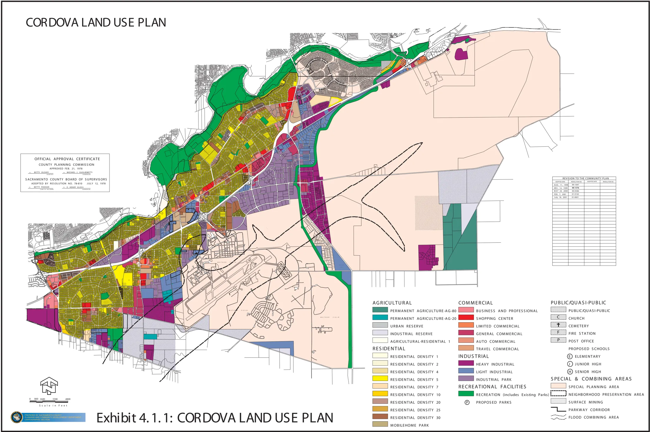
Other non-residential developments consist of manufacturing and distribution facilities, along with warehousing and small contractors operations, which are predominantly located on the south side of Folsom Boulevard, east of Bradshaw Road; and more so on the south side of Folsom Boulevard, east of Sunrise Boulevard, continuing southward almost to Douglas Road. In the late-1970s, as what is now the Gold River area began to develop, several automotive dismantlers were forced to relocate their facilities to an area between the Folsom South Canal and Sunrise Boulevard, north of Douglas Road. In response to growing urban pressures, a South Sunrise Special Planning Area (SPA) was adopted in the late-1980s to both secure the longevity of these dismantling operations, and to institute special development standards based on the unique nature of these uses. The County Branch Center Complex, which houses numerous County Departments and Agencies offices, is located at Bradshaw Road and Kiefer Boulevard. Reclaimed and active aggregate mining operations are a predominant feature of the landscaping being located along Jackson Road, south of Mather; and along the south side of White Rock Road, west of Grant Line Road. The major aggregate companies currently operating within the planning area are Granite Construction, Teichert Aggregates, RMC Lonestar, and American River Aggregates. Granite Construction, in fact, has a large aggregate processing facility located at Bradshaw Road and Kiefer Boulevard, opposite the County Branch Center Complex. And finally, there is Mather, which includes the airport, a commercial office component known as the Mather Commerce Center, a residential component known as Independence, and numerous other features that will be discussed below.
The following tables represent the existing and vacant land use within the Cordova planning area. It is interesting to note that while there does not appear to be an abundance of vacant residentially zoned land, there is an abundance of vacant industrially zoned land within the planning area. The information provided in these tables may be somewhat deceptive due to the manner in which information from the GIS database is classified. Those areas zoned Special Planning Area (SPA), for example, include the GenCorp property (13,000 acres), Mather (5,715 acres), Gold River (1,200 acres), and Villages of Zinfandel (823 acres); all of which consist of very different forms of land use. The General Plan, on the other hand, does not mirror zoning because of the scale of the Land Use Diagram; and in many cases, commercial zoning is considered to be consistent with residential land use designations provided the commercially zoned parcels are less than 10 acres in size.
Table 4.2.1 Cordova Community Planning Area
Total and Vacant Acreage According to Parcel Zoning
Section titled “Table 4.2.1 Cordova Community Planning Area Total and Vacant Acreage According to Parcel Zoning”| Zoning Classification | Total Acres | Vacant Acres |
|---|---|---|
| RD-1 | 15 | 0 |
| RD-2 | 30 | 2 |
| RD-5 | 3,627 | 15 |
| RD-7 | 95 | 11 |
| RD-10 | 321 | 5 |
| RD-20 | 230 | 13 |
| RD-25 | 13 | 0 |
| RD-30 | 305 | 2 |
| RM-1 | 173 | 3 |
| UR | 18 | 0 |
| BP | 155 | 20 |
| GC | 391 | 30 |
| LC | 179 | 35 |
| SC | 237 | 22 |
| AC | 24 | 1 |
| TC | 22 | 0 |
| M-1 | 1,272 | 190 |
| M-2 | 3,059 | 1,419 |
| MP | 1,326 | 445 |
| IR | 1,630 | 780 |
| AR-1 | 4 | 0 |
| AG-20 | 72 | 13 |
| AG-80 | 698 | 121 |
| O | 3,681 | 77 |
| SPA* | 18,853 | 2,236 |
| Other** | 1,220 | Unknown |
| Total | 37,650 | 5,440 |
* Includes GenCorp, Mather, Villages of Zinfandel and Gold River properties.
**Incomplete zoning information.
Source: County of Sacramento 2000 GIS data.
Table 4.2.2 Cordova Community Planning Area
Total and Vacant Acreage According to General Plan
Section titled “Table 4.2.2 Cordova Community Planning Area Total and Vacant Acreage According to General Plan”| General Plan Designation | Total Acres | Vacant Acres |
|---|---|---|
| Low Density Residential | 6,011 | 564 |
| Medium Density Residential | 660 | 32 |
| Commercial and Offices | 1,079 | 238 |
| Intensive Industrial | 5,739 | 1,206 |
| Extensive Industrial | 9,796 | 1,597 |
| Public/Quasi Public | 2,496 | 27 |
| Natural Preserve | 1,750 | 70 |
| Recreation | 3,762 | 225 |
| Other* | 6,353 | 4,921 |
| Total | 37,646 | 8,880 |
* Primarily unparcelized land in the ROW.
Source: County of Sacramento 2000 GIS data.
4.3 GROWTH AREAS
Section titled “4.3 GROWTH AREAS”As previously noted, residential projects such as Independence at Mather, Villages of Zinfandel are already under construction. Sunrise Douglas/SunRidge is a 6,050-acre project with the potential for a total of 22,000 dwelling units. This project has been in process for many years, but recent approvals could lead to a phased construction schedule that could begin as early as summer 2003. Although only a small portion of this project is located within the Cordova planning area, the project will add a significant amount of traffic to those surface streets within the planning area, such as Sunrise Boulevard, Jackson Road and Highway 50.
Within the planning area, the largest development potential obviously lies in the Aerojet property, a vast expanse of property covering approximately 13,000 acres, located south of Folsom Boulevard, between the Folsom South Canal and Prairie City Road. GenCorp did not participate in the community planning process, and publicly has indicated that they are exploring several options for the future use of their property. Perhaps the biggest obstacle will be the federal Superfund designation and groundwater clean-up operations, and how long that process will take. A recent EPA proposal concludes clean-up efforts could take up to 240 years, a timetable that GenCorp has challenged.
GenCorp has publicly stated that they intend to develop a portion of their property, approximately 3,200 acres, fronting Highway 50. They refer to this area as ‘carve out property’, as it has been certified by the EPA as clean from any surface soil contamination, and in 2002, eliminated from the 8,500-acre Superfund designated area. Primary uses for this carve out property would consist of a large office park and hotel. It should be noted that much of this area is outside of the Urban Policy Area (see Exhibit 4.3.1), and as such, would require an amendment to the General Plan. The eventual urbanization of the GenCorp property was envisioned (and supported) by this planning process. However, concerns for a potable water source (may require an amendment to the Water Forum Agreement), traffic mitigation and associated air quality impacts, and adequate assurances for future groundwater clean-up efforts will have to be resolved, prior to any General Plan amendment. There is also a tremendous opportunity for a pedestrian-oriented, mixed-use, multi-modal transportation environment presented by the new LRT station at Aerojet Road. This is an opportunity that exists nowhere else in the unincorporated area due to the vastness and development potential of the GenCorp property.
Another large-scale development proposal located on the Aerojet property submitted to the County in 1998 for development entitlements is Rio Del Oro, which is 3,850 acres in size, and located south of White Rock Road. This property is not located within the federally designated Superfund area, and has a potential to add a total of 15,000 dwelling units to the planning area. A portion of that development proposal (1,100 acres) has since been purchased by Elliott Homes, and as of this writing, there are efforts underway to convert a portion of the application to 2,000 dwellings, and negotiate for the purchase of the remainder of the property subject to the original development proposal. Regardless of the ownership, the Rio Del Oro development is still in the early planning stages, and it may be years before it is approved. It is uncertain as to whether that project can be served by a potable water source.
Mather is itself a growth area; however, the Mather properties have already been subject to considerable planning and environmental efforts, and plans are now in place for the Mather Specific Plan and the implementing mechanism, the Mather Special Planning Area. A related growth area is located to the south of Mather, on lands that currently or have recently been subject to aggregate mining activities. More information on these new growth areas is set forth below.
The final growth area consists of several parcels located along the Folsom Boulevard Corridor that are either vacant or exhibit a strong potential for redevelopment. In fact, many community leaders consider much of the development along this corridor as having a significant ‘infill’ potential, particularly with the extension of LRT to the City of Folsom. Strategies designed to revitalize the corridor, as outlined below, aim to provide greater flexibility in terms of the permitted uses and development standards, and provide incentives to encourage development that is more closely related to and supportive of LRT, particularly for those areas within a 1/4-mile radius of these stations. For the most part, the larger vacant parcels along the corridor are close to LRT stations, and could take advantage of the opportunities provided by convenient public transit access. On the other hand, many of these parcels are surrounded by existing residential development, and in some cases, several unfinished streets stub the boundaries of these large parcels. Therefore, it will be important to balance the LRT transit-supportive and community revitalization goals, and also ensure that these future land uses will compliment existing neighborhoods.
4.4 FOLSOM BOULEVARD
Section titled “4.4 FOLSOM BOULEVARD”Early on in this planning process, it was determined that the most significant opportunities lie along the Folsom Boulevard Corridor. Numerous enhancements to the corridor are already underway (e.g., landscaped medians, building facade improvements, pedestrian safety features). A central business district has been developed in the area bounded by Folsom Boulevard, Zinfandel Drive and Olson Drive. The Rancho Cordova Chamber of Commerce (RCCC) has, in fact, been organizing the formation of a Property Business and Improvement District (PBID) for that portion of the corridor located between Coloma Road and McGregor Road, including properties within the central business district. It is possible to strengthen community identity, one of the general themes to the plan, by creating commercial districts and design guidelines recognizing adjacent neighborhoods as has been done for other corridors such as Franklin Boulevard. There is also the extension of LRT to the City of Folsom, and the unique opportunity to redefine land use around each of the LRT stations. The intent is for this plan to build upon these existing opportunities.
4.4.1 Existing Enhancement Efforts
Section titled “4.4.1 Existing Enhancement Efforts”There are a number of planning efforts underway to enhance the appearance of the Folsom Boulevard corridor. The Rancho Cordova Chamber of Commerce (RCCC) has been working for a number of years to improve the appearance and quality of businesses that locate along the corridor. A special subcommittee, the Cordova Commercial Revitalization Project (CCRP), has been established to assist in the review of development plans, promote landscape improvement, market a building facade rebate program, and lobby for public/private efforts to enhance the appearance of the corridor. This has been a very successful effort, and has included participation by the Sheriff, County Building Inspection, Planning, Code Enforcement, and SHRA. The RCCC is also organizing the formation of a Property Business and Improvement District (PBID) for that portion of the corridor located between Coloma Road and McGregor Road, including properties along Olson Drive. The County Transportation Department in conjunction with the City of Rancho Cordova, is about to embark on an ambitious plan to prepare a streetscape beautification/enhancement project for that portion of the corridor located between Rod Beaudry Drive to Sunrise Boulevard; and also Mather Field Road, between Folsom Boulevard and the Mather Commerce Center. This master planning process is primarily focused on the installation of a landscaped center-median, but may also include preferred frontage landscaping, street furnishings, commercial façade/design standards, building/parking access, and undergrounding of electrical lines.
The new Wal-Mart on Folsom Boulevard, west of Zinfandel Drive.
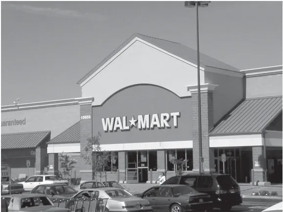
Exhibit 4.3.1: Urban Policy Area/Urban Service Boundary
Section titled “Exhibit 4.3.1: Urban Policy Area/Urban Service Boundary”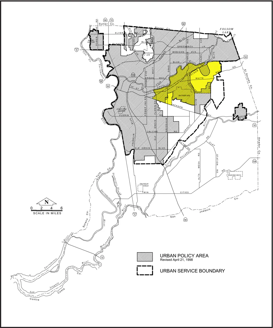
4.4.2 Physical Improvements
Section titled “4.4.2 Physical Improvements”Several new developments have recently been completed or are in progress that will help shape the face of the corridor, and encourage similar development of a higher quality. The Franchise Tax Board has begun construction on a major expansion whereby the facility would be expanded to nearly 1 million square feet, and total employment would increase to approximately 7,500. A new Safeway and Wal-Mart were completed in 2001 near the intersection of Folsom Boulevard and Zinfandel Drive. That project replaced the Cordova Village Shopping Center, but incorporated a Bank of America and PayLess Shoes. That project was a coordinated effort by a single developer, and as a result, there is a common theme to the architecture of the center as well as adjacent buildings. A new Baskin-Robbins and Chevron Service Station have been added near the intersection of Folsom Boulevard and Routiers Road. A new KFC and A&W have been added to the corner of Folsom Boulevard and Coloma Road. At the time of this writing, nearly two dozen commercial building facades for businesses along the corridor have been, or are in the process of being upgraded as a result of efforts of the CCRP, including the Cordova Liquors, Ruffino’s Restaurant, Commercial Kitchen, and Discount Tires.
Construction is currently underway to extend the LRT tracks to the City of Folsom. The timeline for this extension is to occur 2002-2003, with service to Folsom expected by December 2003. An additional 5 stations will be added to the corridor in the following locations:
- Horn Road Station - Southeast corner of Folsom Boulevard and Horn Road.
- Zinfandel Station - Southwest corner of Folsom Boulevard and Zinfandel Drive.
- Cordova Town Center Station - Southwest corner of Folsom Boulevard and Olson Drive.
- Sunrise Station - Southeast corner of Folsom Boulevard and Sunrise Boulevard.
- Hazel Station - Southwest corner of Folsom Boulevard and Aerojet Road.
These new stations present a unique opportunity to create transit-land use linkages. The significance of these station areas is represented by the fact that the stations themselves constitute the only access points to the region’s huge investment in transit infrastructure ($millions), they offer major opportunities to create a multi-modal transportation environment, they represent the potential for a community-wide reduction in vehicle trips and air quality improvements, and they create concentrated activity centers with economic and social benefits for adjacent residents. The challenge is how to capture these opportunities, and at the same time provide assurance to the surrounding neighborhoods that the new development will be compatible and compliment existing development.
4.4.3 INDEX Modeling
Section titled “4.4.3 INDEX Modeling”In conjunction with the community plan update, the Planning Department contracted with Criterion Planners/Engineers to conduct INDEX modeling, a GIS-based sketch modeling computer program for use in transportation/land use planning (see Exhibit 4.4.3). Several of the new LRT station areas were modeled, and with the help of community residents and stakeholders, a preferred land use pattern was developed for each of these station areas. The benefits to this modeling program are in its ability to evaluate pedestrian connectivity, alternative development scenarios, and in the graphical display of that information. It is hoped that Planning Staff can eventually begin to use this program in the evaluation of land use proposals to help create a pedestrian-oriented, mixed-use, multi-modal transportation environment around each of these LRT stations. The use of this program can also prove to be valuable in evaluating various land use proposals, alternative courses of action, and to monitor implementation actions to insure progress is being made toward the goals that are set by this planning exercise.
Some of the early successes that were achieved using the INDEX modeling program included the ability to make a case against a proposed auto sales business near the future Hazel/Aerojet LRT Station. That proposal, if approved, would have resulted in a used car sales business on a 2.0acre site located immediately across from the planned LRT station. That site, currently vacant, would be highly desirable for some type of transit-supportive use. In the very least, the site would be more appropriate for some type of commercial businesses (e.g., video sales, child care, coffee, and dry cleaners) that could provide services not only to LRT riders, but also to residents of the adjoining apartment complex. An auto sales business was clearly not a benefit to the larger community, LRT riders, or to adjacent land uses. In that case, the INDEX modeling focused on employment, LRT ridership, and the need for additional services to provide a more ‘complete’ neighborhood.
The INDEX model was also used to assist RT and the community identify the best locations for the future Zinfandel and Kilgore LRT Stations. Several factors were considered in that analysis including employment and residential densities, and walk distances to various station location options. Ultimately, RT agreed to a shift in the locations of both of these stations to provide better access to the adjacent commercial centers, services such as banking and the Post Office, and residential neighborhoods. INDEX was able to demonstrate that a shift in these stations represented an overall improvement in the walk distances for uses. And finally, arising out of the modeling conducted in conjunction with the Zinfandel and Kilgore station analysis was the identification of a needed pedestrian crossing of Highway 50, east of Zinfandel Drive. This connection was seen as a benefit to overall circulation, as it would allow the employees of the business parks south of the freeway a safe and convenient access to commercial shopping at the business district bounded by Olson Drive, Folsom Boulevard and Zinfandel Drive, as well as access to lunch opportunities and to LRT. A potential funding source for the crossing may be through the SACOG’s new Community Design Element of the Metropolitan Transportation Plan (MTP). By 2004, it is expected that approximately $500 million (phased over a 20-year period) will be available through the MTP to incentivize ‘smart growth’ private/public projects that will help reduce vehicle trip and associated air quality impacts.
Exhibit 4.4.3: INDEX Computer Screen Shot
Section titled “Exhibit 4.4.3: INDEX Computer Screen Shot”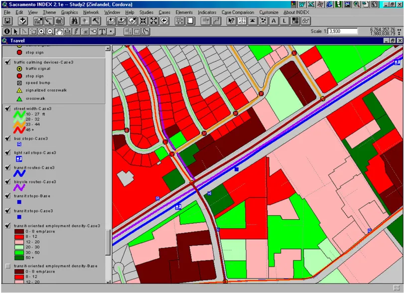
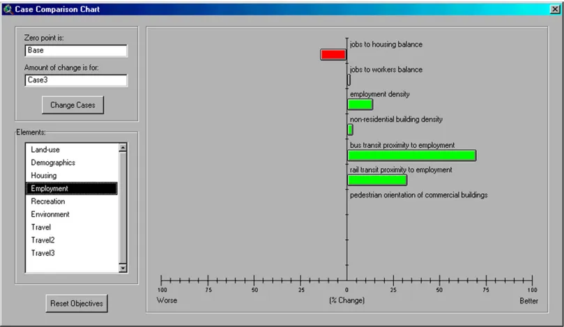
4.4.4 Folsom Boulevard Corridor Special Planning Area
Section titled “4.4.4 Folsom Boulevard Corridor Special Planning Area”As indicated previously, Folsom Boulevard was the main route or highway from Sacramento to South Lake Tahoe. Much of the existing zoning and land uses still reflect this ‘traveler-oriented’ character that was desirable before the construction of Highway 50. Today, the remaining zoning, particularly the AC and TC zoning, is much too restrictive for businesses that intend to cater to the larger community. In addition, many of the parcels that front the corridor are shallow and in separate ownership, which makes compliance with the current development standards and/or joint development opportunities problematic. A Special Planning Area (SPA), or similar mechanism, can offer relief in the form of a broad range of uses (i.e., no restrictions related to specific zoning designations) and flexible development standards.
A SPA was, if fact, developed for the Folsom Boulevard corridor during the community plan process, and was originally intended as a companion document to the plan, and as an implementation tool to promote the 3 general themes: Community Identity, Revitalization and Traffic Management. It is anticipated that the SPA can stimulate the revitalization/reuse of existing land uses on the corridor, and promote development that will be supportive of LRT. The SPA was crafted to legalize all existing land uses. Land use districts (e.g., Commercial/Residential and Central Business District) are identified in the attached exhibits (see Exhibit 4.4.5), and these are based primarily on the character of existing development and some of the suggestion arising out of the INDEX modeling workshops. A permitted land use table, similar to those tables within the Sacramento County Zoning Code indicates the permitted uses by district, and references specific zones that provide for a greater range of uses for the most part than those currently permitted on specific parcels. These permitted uses are typical of the general character of the immediate area. Flexibility in development standards, in the form of shared parking and reduced setbacks, is also provided. Greater flexibility in these standards will assist in the revitalization of smaller parcels.
General guidelines are also included to indicate preferred design in both residential and commercial construction. These guidelines include preferred building facades, materials, signage, landscaping, and building orientation that will help create a more attractive appearance and vibrant pedestrian environment for the streetscape. The intent is not to discourage new development or redevelopment of existing businesses, but to encourage good development that will further the 3 general themes of this planning document, and is representative of what is expected by the community. It is recommended that a local entity (possibly CORPAC) be given design review authority to review building permits for uses that would otherwise be permitted by zoning so that design consistency can be achieved. In the event of disagreement, an appeal mechanism for a nominal fee will be available.
The SPA also contains a mechanism to address transit-supportive development around each of the LRT stations. Exhibits are attached (see Exhibit 4.4.5) that identify a 1/4-mile radius around each of the LRT stations. Within these areas, the SPA encourages transit-supportive development by several methods. Transit-supportive development is defined as mixed-use developments, or any development that is consistent with the ‘Transit-Supportive Guidelines’ (included within the SPA), floor area ratios, and other standards that are included within the SPA for such development; and is determined by the Planning Director to establish a linkage to public transit in such a manner to result in a reduction in the number of vehicle trips in the larger project area. An example of a transit-supportive development would be the expansion of the Franchise Tax Board and its relation to the Butterfield LRT Station. These guidelines will help ensure that development around these LRT stations will encourage and provide convenient access for residents, employees and patrons to LRT facilities.
The first incentive included in the SPA to encourage transit-supportive development is the standards themselves. The SPA will allow this type of development at a greater building height, reduced building setbacks, and with reduced parking regulations than would not be possible under the current zoning (e.g., a maximum building height of 100-feet, no front-yard setback requirement, and a maximum 50 percent reduction in parking over that which would otherwise be required based on the use). Residential projects are also allowed at a much higher dwelling density (e.g., a maximum residential density of 80 units per acre). The second incentive consists of reduced entitlement processing time (both Planning and Environmental), as well as a reduction in the required fees for such review. By far the most important incentive to this strategy relates to a variety of financial incentives through means such as reduced Roadway and Transit fees, Sewer Connection Credits, transit pass subsidies, and advertising subsidies.
The concept of incentives is very important to revitalization of land uses along the Folsom Corridor. Many of the financial incentives outlined in the SPA are intended to apply to ‘revitalization’ as well as to ‘Transit-Oriented’ uses. However, many of these incentives included in the SPA have not yet been approved, and may have implications that extend far beyond the Cordova planning area. As of this writing, a strategy for the use of sewer connection credits is being discussed as a method to encourage economic development. It is likely that this strategy could cost jurisdictions millions of dollars in lost revenues, and thus is a strategy that would need to be approved by all of the jurisdictions that participate on the regional board. A broad range of incentives is still possible (e.g., reduced road and transit fees, state and federal grants such as CDBG, TEA-21, CMAQ and the HUD Jobs-Housing Balance, and SACOG’s new Community Design Program). Incentives will play a greater role if the importance of achieving an urban form that truly is a pedestrian-oriented, mixed-use, multi-modal transportation environment is recognized and supported by decision-makers. Once again, it is likely that this will be a strategy that has to be more regional in nature, and likely established by or in conjunction with the work that SACOG is currently doing to address important regional transportation and land use issues.
Exhibit 4.4.4: Folsom Boulevard SPA Boundary
Section titled “Exhibit 4.4.4: Folsom Boulevard SPA Boundary”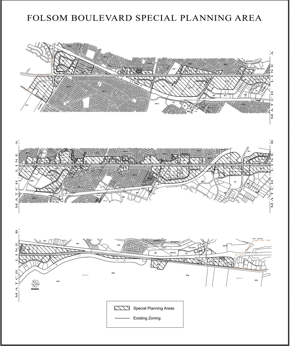
Exhibit 4.4.5: Sample SPA Land Use Exhibit
Section titled “Exhibit 4.4.5: Sample SPA Land Use Exhibit”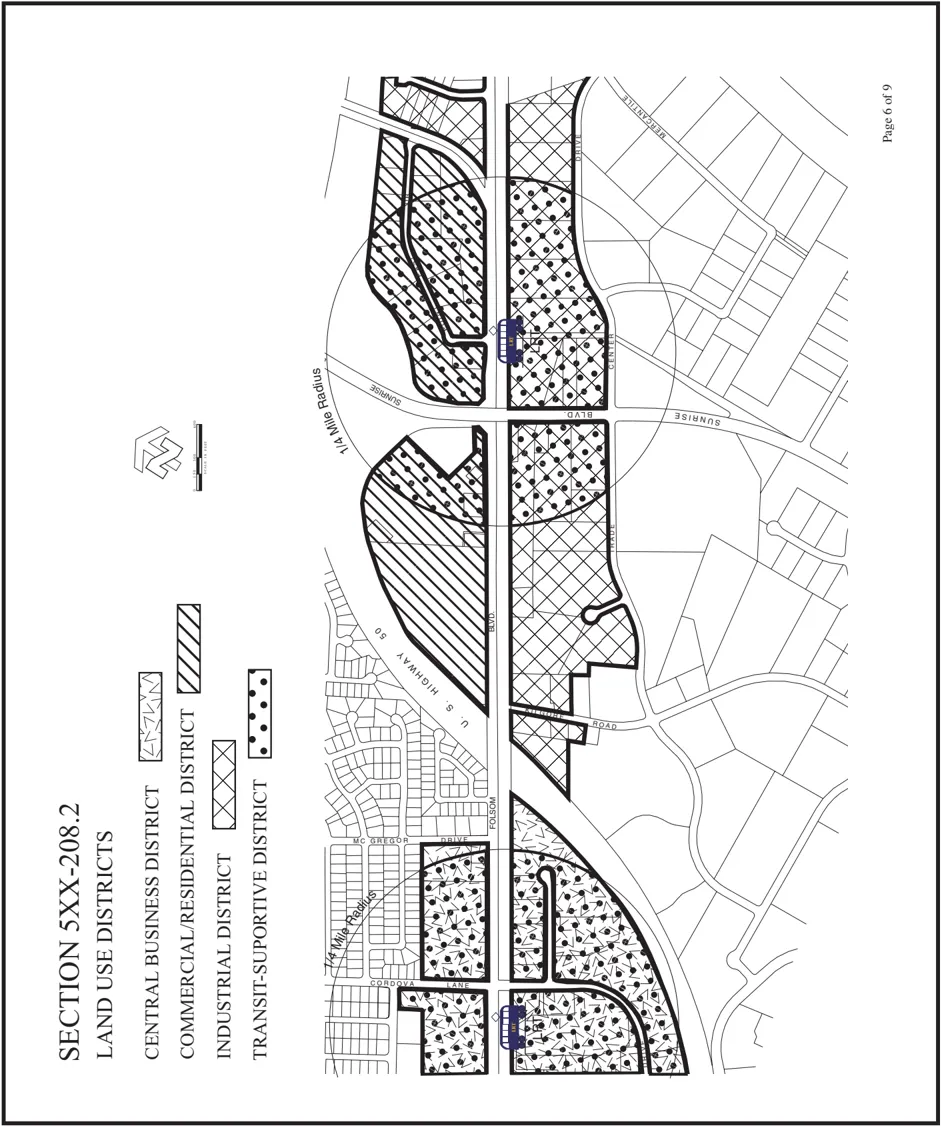
4.4.5 Recommendations
Section titled “4.4.5 Recommendations”- Implement a Special Planning Area, or similar mechanism, for the Folsom Boulevard Corridor that supports the revitalization of businesses and neighborhoods along the boulevard.
- Utilize GIS-based modeling programs such as INDEX in the evaluation of various land use proposals, particularly those adjacent to LRT stations, and alternative courses of action in the project analysis and recommendations.
- Develop an incentive package to provide financial incentives to encourage linkages between LRT stations and adjacent land uses, particularly within a 1/4-mile radius of the LRT station.
- Work with neighborhoods to coordinate ‘infill’ planning efforts with community development/revitalization goals, and ensure that these future land uses will compliment existing development.
4.5 MATHER (FORMERLY MATHER AFB)
Section titled “4.5 MATHER (FORMERLY MATHER AFB)”In 1988, the Federal government formally announced the closure of Mather Air Force Base, a facility totaling 5,715 acres. The Mather aviation facilities (approximately 2,900 acres) were subsequently transitioned over to the County of Sacramento. In 1995, Mather was officially reopened as a civilian airport. As of this writing, air cargo carriers such as UPS, Airborne Express, and Emery operate at the facility; and air cargo volumes are one-half or greater than that occurring at the Sacramento International Airport. Approximately 800 acres were also transitioned to private enterprises such as McCuen Properties, and together with other developers, they are in the process of developing approximately 1 million square feet of commercial office development known as the Mather Commerce Center. Kaufman & Broad is in process of developing a 1,272-unit single-family project known as Independence at Mather, in the vicinity of the old military housing complex. The County Department of Parks, Recreation and Open Space has acquired approximately 1,450 acres, and is in the process of developing the Regional Park. The Cordova Recreation and Park District received as a conveyance from the federal government, a large recreation complex near the entrance to the facility at Mather Field Road.
4.5.1 Existing Approvals
Section titled “4.5.1 Existing Approvals”In the late 1990s, several land use approvals occurred that would help shape the future development of Mather. The first was the Mather Airport Policy Area (MAPA), an amendment to the County General Plan. This policy statement and accompanying map (Exhibit 4.5.1) was intended to provide an additional envelope of protection for the Mather airport by prohibiting residential development in those areas subject to noise levels of 60 Community Noise Exposure Level (CNEL) or above, whereas the Mather Airport Comprehensive Land Use Plan (CLUP) adopted by the Airport Land Use Commission prohibits new residential development only in those areas subject to noise levels of 65 CNEL or above. In addition, this policy statement requires additional insulation measures for home construction within the MAPA, but outside the 60 CNEL; a disclosure in the Public Report to new homebuyers of property within these areas that they are located within the MAPA; and the granting of an avigation easement for all properties located within the MAPA. The MAPA is intended not only for community safety, but also to prevent unreasonable constraints on the growth of the airport as a premiere air-cargo facility.
The next land use approval was the Mather Specific Plan and the Mather Special Planning Area. These documents cover all 5,715 acres of the former Air Force Base land, and regulate land use based on various land use districts. The objectives were to provide for a 11 million square foot airport-business complex oriented to aviation-related facilities, revitalization of the main base area, creation of a regional park, rehabilitation of the old base housing, preservation of on-site vernal pools, and to create a new commercial-recreation attraction on a 520-acre parcel (Economic Development Conveyance) located at the southeast corner of this area. A Redevelopment Project Area has been created, and covers about 2/3 of the 5,715 acres, including the airport, residential housing and Mather Commerce Center. Several new roadways were proposed, including new connections/extensions for Mather Boulevard, Eagles Nest Road and Zinfandel Drive, Douglas Road, Kiefer Boulevard and Routier Road. A capital improvement program was also included, with a total cost of $115 million for all of the necessary infrastructure. As of this writing, the financing plan has not yet been approved, nor has the precise location of new roadways been defined, as this will require FAA approval.
Exhibit 4.5.1: Mather Airport Policy Area
Section titled “Exhibit 4.5.1: Mather Airport Policy Area”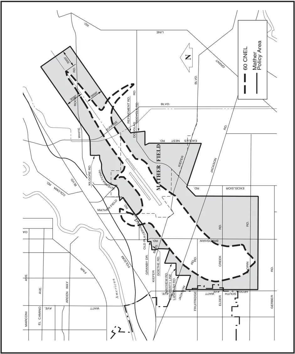
4.5.2 Growth Potential
Section titled “4.5.2 Growth Potential”The Mather complex is growing at a phenomenal rate. To date, approximately 600 dwellings within the Independence at Mather project have already been sold. Plans have recently been completed for the Regional Park showing festival grounds, bike trails, nature center, soccer and rugby complex, velodrome, and vernal pool preservation area. There is still ample land remaining for other park facilities should the need arise. It should be noted that by comparison, this park is 596 acres larger than Golden Gate Park in San Francisco, and 770 acres larger than Central Park in New York City. Under contract with Sacramento County, McCuen Properties markets land within what is known as the Mather Commerce Center. Today, there is only about 40-50 acres remaining within the Commerce Center that is uncommitted, in addition to the Economic Development Conveyance (EDC) lands of 64 acres located on Douglas Road east of the airport, and 523 acres located at the southeast corner of the complex. Many offices have already been constructed within the Center, including those for prestigious firms such as McGraw-Hill, Sutter Health, and Security National Servicing Corporation. Sacramento County offices for Real Estate, Water Resources, Water Quality, and the Business Environmental Resource Center are also located within the Center. Both the County Departments of Animal Care and Regulation and Parks, Recreation and Open Space indicate that they plan to construct offices and related facilities at Mather. Construction of an 110,000 square foot building for the Office of Emergency Services is currently underway within the Center.
Airborne Express cargo plane being loaded at Mather Airport.
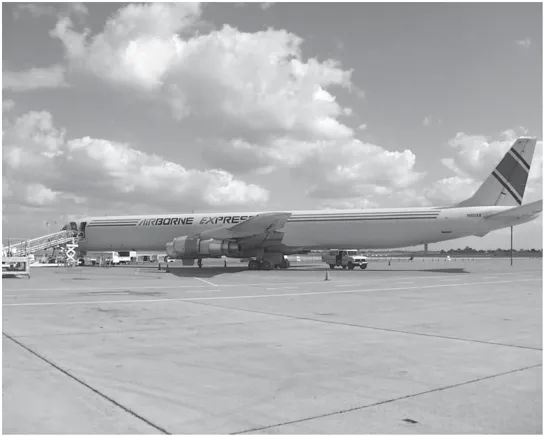
As indicated above, Mather serves as both a general aviation and air cargo facility, and is well on its way to becoming a premiere air-cargo facility. The airport features all of the services and amenities that one would expect from a major air cargo hub. It features one of the longest runways in California (Runway 4R/22L which is 11,300 feet in length) and is capable of accommodating the largest fully-loaded aircraft in use today. Twenty-four hour air traffic control services as well as rescue and fire fighting services are available. Mather also boasts 40 acres of cargo ramp space, over 300,000 square feet of warehouse space and nearly 200,000 square feet of office space. Located 12 miles east of Downtown Sacramento, the airport provides access to a local market of nearly 2 million people, with an additional market of over 9 million within a 90-mile radius. It is also convenient for users because of its proximity to major freeways, transcontinental railway lines, and a deepwater port.
Exhibit 4.5.2: Mather Land Use Plan
Section titled “Exhibit 4.5.2: Mather Land Use Plan”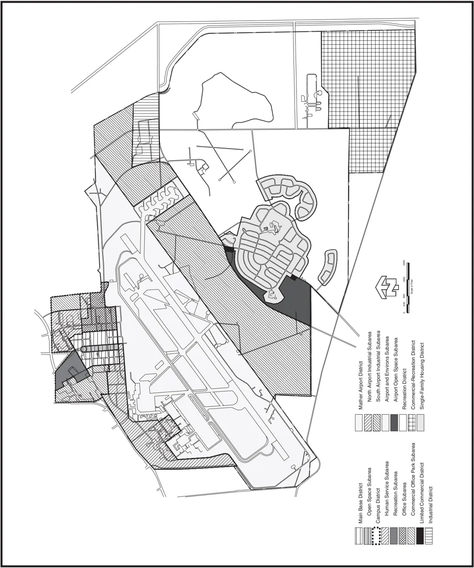
Business at the airport is booming. Approximately 167,000 tons of air cargo was shipped through the airport in 2000, a 72 percent increase over 1999. Mather itself is home to nearly 20 businesses, including major air cargo carriers such as UPS, Airborne Express, and Emery. Many local companies such as Intel, Apple Computer, and Siemas Duewag use the airport as ‘home base’ for their fleets of executive jets. Annually, the airport creates more than 1,300 jobs, which in turn generate more than $52 million in additional revenue throughout the Sacramento region. Further, the airport generates over $143 million in business revenue, and more than $7 million in state and local taxes. Clearly, Mather complex is an economic engine for this community, as well as for the region.
Sign at entry to the Mather Commerce Center.
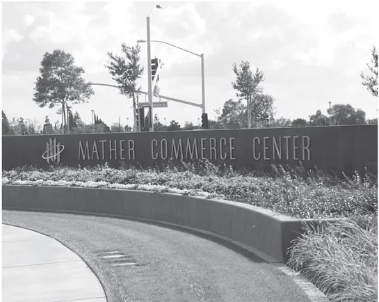
Growth of the airport business is dependent on avoidance of any unreasonable land use conflicts, and of course, on the continued support of the community and local decision-makers. Recent land use decisions have been made with the recognition that there could be impacts to operations at the airport; primarily, from an increase in noise complaints by nearby residents. Residential developments such as the Villages of Zinfandel and Independence at Mather were evaluated for potential conflicts from nearby aircraft operations. Several new schools, including Rosemont High School located at Kiefer Boulevard and Mayhew Road, serving these residential areas have also been carefully scrutinized for aircraft safety hazards. By and large, decisions have been made that these uses can reasonably co-exist. It should be noted that recent technological advancements have lead to a quieter aircraft engines, and these advancements should continue over time.
The County is, at the time of this writing, conducting an update of its Airport Policy Plan, which will examine the role of the Mather in the overall Airport System, facility requirements and development constraints. Several alternatives to lengthening the second runway at Mather are being evaluated. These alternatives range from constructing a new full runway between the main runway (4R-22L) and the control tower at a cost of $103 million; to a pavement overlay extension, the addition of lights, and a visual approach slope indicator to the north runway (4L-22R) at a cost of $10-15 million. The alternative that would meet the basic needs of the air cargo industry, and at the same time have the least impact on the community would involve extension of the north runway for use by heavy jet aircraft only in the event that the main runway is unavailable due to maintenance or aircraft mishaps. It is expected that such usage would be infrequent, occurring only a few days per year. Other alternatives are very expensive and could result in new flight patterns, potential safety hazards for nearby schools, and greater noise impacts to nearby residential neighborhoods. In fact, it is likely that a large portion of Villages of Zinfandel would be precluded from developing the previously approved residential uses due to the new flight patterns. In addition, safety approvals by Caltrans Division of Aeronautics have already been granted for new schools such as Rosemont High School, which is scheduled to open in 2002, and can’t be reversed. The future of Mather will have to be evaluated in the context of the overall Airport System, and in light of land use decisions that have already occurred. It is hoped that the decision will focus on the long-term potential of the airport.
Mather has the potential to become a regional cargo hub, the potential for attracting international cargo service, and perhaps passenger traffic as well without compromising previous land use decisions. Several case studies have been conducted on airports, and their impacts on urban growth and form; most notably those studies by the renown Professor of Economics from the University of North Carolina, John Kasarda. Mr. Kasarda has found that cargo airports induce significant job growth. An analysis of employment growth in the suburban rings of U.S. metropolitan areas shows that the job growth rate for areas within 4 miles of airports is two to five times faster than the overall job-growth rate for the suburban ring within which the airport is located. Further, most of the employment is concentrated around the airport or along a major access corridor within 15 minutes of the airport. A new measure for determining land value may become time-cost access to the airport. Firms of various types may bid for accessibility predicated on the value each gives to reducing the time-cost of moving people and goods to and from the airport. He predicts that dedicated expressway links and rail access will efficiently connect airports to nearby and more distant business and residential centers. Special truck-only lanes may be added to airport expressways as well. Air-commerce clusters and spines of a distinct spatial form already exist around some of the major international gateway airports.
The benefits for Mather is that it is located 12 miles east of Downtown Sacramento, the airport provides access to a local market of nearly 2 million people, with an additional market of over 9 million within a 90-mile radius. It is also convenient for users because of its proximity to major freeways, transcontinental railway lines, and a deep-water port. There is ample space on Mather that is still available for development. For example, there is approximately 700 acres (South Airport Industrial Sub-Area) south of the main runway that has been set aside for larger airportdependent uses. Properties south of Mather, currently used for aggregate extraction, should also be considered for airport-dependent uses such as manufacturing and distribution centers. These properties to the south of Mather are currently zoned Industrial Reserve, and are subject to high noise levels rendering them unacceptable for residential use. The addition of new roadways on Mather will greatly improve accessibility to these adjacent properties. Nearby residential projects, most notably Villages of Zinfandel and Independence at Mather, provide convenient housing for those employed in this growing industry.
4.5.3 Recommendations
Section titled “4.5.3 Recommendations”- Identify areas where high technology industry, business park uses, and industries such as manufacturing and distribution that provide support for Mather air-cargo operations and need close proximity to the airport can locate; and support the development of such uses.
- Carefully evaluate the relationship of land uses, particularly residential uses to Mather Airport, and the impacts to the growth of the air-cargo industry, and weigh those impacts against the need for additional housing in the community.
4.6 AEROJET
Section titled “4.6 AEROJET”The largest development potential within the planning are lies in the Aerojet property, a vast expanse of property covering approximately 13,000 acres, located south of Folsom Boulevard, between the Folsom South Canal and Prairie City Road. GenCorp has been exploring several options for development of this property. They have indicated that there are plans for a 3,200acre business park along the Highway 50 Corridor (discussed below), but did not participate in the community planning process. The only entitlement application submitted to the County (1998) is for a large-scale development (predominately residential) known as Rio Del Oro, which is 3,850 acres in size, and located south of White Rock Road. A portion of that development proposal (1,100 acres) has since been purchased by Elliott Homes, and as of this writing, there are efforts underway to convert a portion of the application and negotiate for the purchase of the remainder of the property subject to the original development proposal.
Aerojet has operated at the Rancho Cordova site since 1953. Its operations include manufacturing liquid and solid propellants for rocket engines for military and commercial use, and formulating chemicals including rocket propellant agents, agricultural pesticides, pharmaceuticals, and other industrial chemicals. Some wastes from these manufacturing activities on the Aerojet property were disposed of in surface impoundments, landfills, deep injection wells, and open burn areas. As a result of these former disposal practices, contamination of groundwater extends off the Aerojet property; and in 1984, the Environmental Protection Agency (EPA) designated the property north of White Rock Road (about 8,500 acres) as a highly contaminated federal Superfund site. That portion of the Aerojet property (acquired in 1984) located south of White Rock Road, was previously owned by McDonnell Douglas and is also contaminated from former disposal practices, although Boeing, McDonnell Douglas’ successor, is responsible for that cleanup.
In 1989, Aerojet, the EPA, the state’s Department of Toxic Substance Control (DTSC), and the Central Valley Regional Water Quality Control Board (CVRWQCB) signed an agreement (Partial Consent Decree) in which Aerojet accepted responsibility for contamination from defense contract operations, agreed to investigate the scope of that contamination, and take steps to remediate the problem. As of this writing, Aerojet has drilled over 1,000 monitoring wells, constructed 6 groundwater extraction and treatment facilities, and treated over 50 billion gallons of groundwater. Perchlorate was first detected off of the Aerojet property in 1997, when the ability to measure perchlorate significantly improved. Due to the discovery of these new contaminants in the groundwater, local water purveyors (Arden-Cordova Water Service, Citizens Utilities, and the County of Sacramento) have had to shut down several drinking water supply wells in the area to protect the public.
Over the past several years, Aerojet has been negotiating with federal and state agencies to amend the Partial Consent Decree. Aerojet requested that 3,200 acres along the Highway 50 Corridor (see Exhibit 6.1.1) originally subject to the 1989 Decree be ‘carved out’ of the Superfund designated area. Several additional changes to the Decree were proposed as well that are intended to speed cleanup operations and allow for easier development of these properties. The benefits from this proposal would be potentially faster groundwater cleanup, a new legal guarantee of $75 million for cleanup funding, benefits from re-use of properties, and a new interim water supply contingency plan. In 2001, the EPA, DTSC, and the CVRWQCB certified this area to be clean, and in 2002, a federal court finalized the proposal.
Even thought Aerojet has been successful in carving out 3,200 acres from the 8,500-acre Superfund designated area, there are still numerous hurdles to overcome before this portion of the property can be developed. Perhaps the biggest hurdle is the fact that only a small portion of the Aerojet property is located within the Urban Policy Area (see Exhibit 4.3.1), and as such, would require an amendment to the General Plan. Concerns for a suitable potable water source, increased traffic and air quality impacts, growth inducement, and adequate assurances for future groundwater clean-up efforts will have to be addressed, prior to any General Plan amendment. Representatives of the Water Quality Division have indicated that sewer truck lines are being sized on the assumption that the Aerojet property will eventually urbanize, and capacity will be available for a residential density of 6-7 dwellings per acre on this property. Water supply, on the other hand, is a very different matter. The Aerojet property is located within the service area of the Folsom Water District; however, the Water Forum did not factor eventually urbanization of the Aerojet property into the Water Agreement. The primary reason for this oversight is that only those properties located within the Urban Policy Area were considered for urban development served by a public water source. Aerojet is considering several water sources for new development including the reuse of treated groundwater, new water supply wells, and the discharge of treated water to surface waterways and withdraw (exchange) up to those discharges amount from either the American River or Folsom South Canal below the discharge point.
Despite these development hurdles, the community planning process envisioned (and supports) some limited development of the Aerojet property within the next 10 years. It will be critical to work closely with GenCorp in the initial development of land use concepts for their property to ensure that eventual development will be integrated into the community. It is possible that areawide circulation problems can be addressed given the vastness of this property. There is also a significant opportunity to capitalize on the location of the new LRT station at Aerojet Road and provide a pedestrian-oriented, mixed-use, multi-modal transportation environment surrounding this new station. This is an opportunity that exists nowhere else in the community, nor unincorporated areas, because of the lack of existing development and vastness of this property. Check lists based upon the themes outlined in this plan can be developed to help evaluate various development proposals on the Aerojet property. The following questions may help to form the basis for an initial checklist:
- How might the proposed development enhance circulation within the community, or on a larger scale?
- Will the proposed development create an attractive place in which to live, work, shop and recreate, with less reliance on the automobile?
- Is the design, landscaping and general nature of the proposed development consistent with or complimentary to themes promoted within the larger community?
- How might the proposed development identify with and relate to the larger community?
- How might the proposed development help promote a positive image for the larger community?
- Does the proposed development consist of uses that will contribute to ‘neighborhood completeness’ in the larger sense so as to result in reduced demand for use of the automobile?
Exhibit 4.6.1: Aerojet ‘Carve Out’ Lands
Section titled “Exhibit 4.6.1: Aerojet ‘Carve Out’ Lands”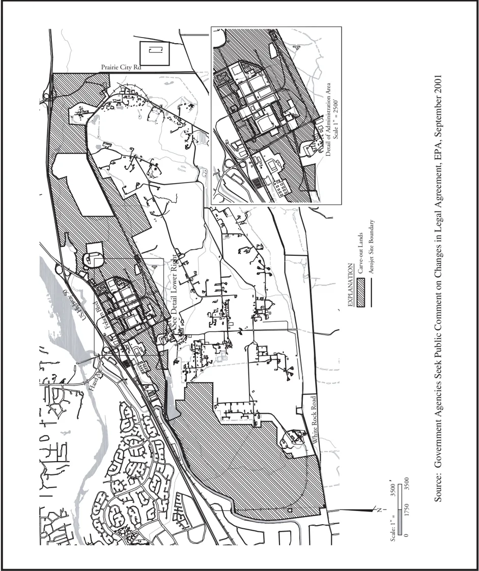
4.6.1 Recommendations
Section titled “4.6.1 Recommendations”- Work closely with GenCorp in the initial development of land use concepts for their property to ensure that that eventual development will be integrated into the community, recognize the area-wide circulation problems, and capitalize on the opportunities for a pedestrian-oriented, mixed-use, multi-modal transportation environment presented by the new LRT station at Aerojet Road.
5.0 URBAN DESIGN AND NEIGHBORHOOD CHARACTER
Section titled “5.0 URBAN DESIGN AND NEIGHBORHOOD CHARACTER”OVERVIEW
Section titled “OVERVIEW”Urban design is closely related to land use, but relates more to how that land use is designed. It relates to architecture and design, and helps provide people with a ‘sense of place’ as they move about the area. Themes or zones of influence can help establish a particular identity for a commercial corridor, particularly in the case of Folsom Boulevard because of its length and homogenous development patterns. Street signs, street furniture, banners, and pedestrian connectivity can unify a commercial corridor with adjacent neighborhoods. Streetscape enhancements such as median landscaping, pedestrian-scale streetlights, and wide or separated sidewalks can help to encourage a lively pedestrian environment, particularly along commercial corridors. New activity centers can be created at LRT stations, as well as a multi-modal transportation environment. This chapter focuses on those design measures that will help create a safe, attractive and vibrant urban environment for commercial corridors, employment centers, and neighborhoods.
5.1 COMMERCIAL CORRIDORS
Section titled “5.1 COMMERCIAL CORRIDORS”There are many commercial corridors within the Cordova planning area, and none have any particular general design themes or design regulations that are imposed on development. The County Planning Department is currently pursuing a countywide study to identify design guidelines for new retail, office, and business park development. Streetscape beautification/enhancement efforts by the County Transportation Department have lead to master plans that include deign guidelines for several corridors throughout the County, and a similar planning effort is scheduled to begin soon for portions of Folsom Boulevard and Mather Field Road.
Of all of the particular commercial corridors within the Cordova Planning area, Folsom Boulevard exhibits the most potential to benefit from design guidelines because of the number of improvements that will occur to this corridor over the term of this planning period, and the opportunity to provide some coordination to the various efforts. The extension of LRT from Mather Field Road to the City of Folsom will occur in 2002-2003, and will include 11 miles of track, 9 new stations, and more than 1,000 parking spaces. The new LRT stations will create opportunities for new development and transit linkages, better access to community services, and an alternative to vehicular commutes. RT has embarked on their own planning exercise (Transit for Livable Communities) to identify suitable new development and transit linkages at these LRT station areas. Efforts are on-going by the Rancho Cordova Chamber of Commerce; and in particular, it’s subcommittee for the Cordova Commercial Revitalization Project, to promote various improvements such as an on-going facade improvement program (currently administered by SHRA) for businesses along the corridor, a pending streetscape beautification project (to be funded by the County Transportation), a pending pedestrian-safety project (jointly funded by RT, County Transportation and SHRA) in the vicinity of the Mather Field/Mills LRT station, and in the formation of a Property and Business Improvement District (PBID) for property owners between Coloma Road and McGregor Road. In addition, new development along the boulevard such as the recently constructed Wal-Mart/Safeway project located at Zinfandel Drive and Folsom Boulevard will help promote redevelopment.
Large freestanding sign for a single tenant on Folsom Boulevard.
5.1.1 Recommendations
Section titled “5.1.1 Recommendations”- Develop urban design and architectural guidelines that encourage pedestrian-friendly and human-scale development.
- Appoint a local entity (e.g., CORPAC) as the review authority for all building permits for development along the Folsom Boulevard Corridor.
- Implement a Special Planning Area, or similar mechanism, for the Folsom Boulevard Corridor that provides guidelines for architecture, streetscape enhancements, signs, and local design review of all development along the boulevard.
- Support the County’s beautification project for Folsom Boulevard, and encourage similar improvements to Coloma Road, Sunrise Boulevard, and Mather Field Road.
- Require that all applicants for cellular facilities submit appropriate justification for single ‘stand alone’ facilities, and demonstrate through coverage statistics why such facilities cannot be relocated to a less visible site, or modified in design (e.g., modified to resemble a flag pole or tree) to be less apparent.
5.2 LRT STATION AREAS
Section titled “5.2 LRT STATION AREAS”The LRT stations provide a tremendous opportunity to plan for new development within the 1/4mile radius (i.e., within a reasonable walk distance to the LRT station). The significance of these station areas is represented by the fact that the stations themselves constitute the only access points to the region’s huge investment ($millions), and they offer major opportunities to create a multi-modal transportation environment. Further, these areas represent the potential for a community-wide reduction in vehicle trips and air quality improvements, and they create concentrated activity centers with economic and social benefits for adjacent residents. SACOG has indicated that they expect one million new residents and a half million new job in the 6-county region by 2025. It is also widely recognized that it is becoming more difficult to meet the standards the federal government sets for this region in terms of a ‘severe non-attainment area’. Critical land use and transportation choices affecting quality of life need to be made now.
Photo composition showing how the Mather Field/Mills Station might appear with a ‘Transit-Supportive’ land use pattern developed at the station.
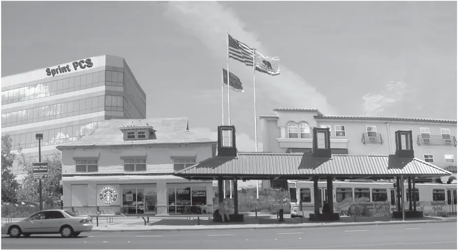
There are two factors that must considered in planning for these areas; the type of uses that should be encouraged, and the design of those uses. This will involve a new way of doing business in terms of land use planning, and is most similar to that which is typically conducted for a central-city area. Land uses must be intensified, both in terms of employment and residential density so as to create a transit-land use linkage. This linkage must also be enhanced by amenities such as movie theatres, cafes, shopping and other support services to help create a desirable environment in which to live, shop, work and recreate. How buildings are designed or development is laid out is also important.
Buildings and uses should be intertwined so that pedestrians can move about within the …-mile area with ease. Mixed-uses where commercial businesses occupy the ground floor with residential or offices on the upper levels are highly desirable in these areas. Pedestrian connectivity is very important in helping create a lively and inviting streetscape, an increase in patronage for business along the Folsom Boulevard Corridor, and a healthy community. It is unfortunate that much of the development that occurs today in the unincorporated area encourages the use of the automobile by creating obstacles to pedestrian access (e.g., perimeter fences, heavily landscaped perimeter planters, and an abundance of parking situated between the buildings and the street). Guidelines similar to those included within the SPA prepared for the Folsom Boulevard Corridor will help to create a more pedestrian-friendly environment along the corridor by allowing reduced building setbacks, common parking facilities, and mixed-uses. The use of INDEX modeling as described in Chapter 4 can also help evaluate walk distances between uses and to points of access such as the LRT stations, and will enhance the tools that planners have to promote pedestrian connectivity. However, the design of buildings and the layout of that development is really the influencing factor in promoting an individual’s desire to walk rather than drive.
5.2.1 Recommendations
Section titled “5.2.1 Recommendations”- Work with RT and landowners to develop a central plaza at the Mather Field/Mills LRT Station where community events could be staged.
- Implement a Special Planning Area, or similar mechanism, for the Folsom Boulevard Corridor that provides guidelines for transit-supportive development at the LRT stations along the boulevard.
- Employ new planning tools (e.g., GIS-based sketch modeling programs such as INDEX) to evaluation of various land use proposals, particularly those adjacent to LRT stations, pedestrian connectivity, and alternative courses of action in the project analysis and recommendations.
- Promote the elimination of barriers (e.g., power poles and electrical transformers) and installation of separated sidewalks to create a more attractive and active pedestrian streetscape environment, particularly adjacent to the LRT stations.
- Use various incentives to promote reuse of property adjacent to the LRT stations.
- Encourage build-out of vacant and underutilized property adjacent to the LRT stations.
5.3 EMPLOYMENT CENTERS
Section titled “5.3 EMPLOYMENT CENTERS”Employment centers are a highly desirable land use for the LRT station area. The Franchise Tax Board (FTB) is an excellent example of an employment center that will provide a transit-land use linkage. Once the FTB expansion is completed, this center will employee approximately 7,500 workers that will have direct access to the Butterfield LRT Station. The proposed expansion plan will eliminate Butterfield Way, and expand the buildings so that the main entry will front a plaza located adjacent to the LRT platform. Residential is also an important component to employment centers, as well as the mix and variety of uses located at these LRT stations. For many years planning efforts have been focused on providing clearly distinct and separate areas for commercial and residential uses. The new thinking, often referred to as ‘new urbanism’, encourages the integration of land uses, and greater connection/relationship between these uses. As indicated above, it is often preferable to locate commercial and residential uses within the same building. New industrial areas also often contain a residential component known as a ‘livework’ zone where residential units are permitted above certain businesses (e.g., a contractors business/showroom).
Support services such as cafes, dry cleaners, video rental, and day care are critical for a healthy employment center. These support services create a more desirable place to work, and help to reduce the need for additional vehicle trips. It is unfortunate that the Highway 50 business parks were not planned with the adequate support services. Although the Office Park (MP) zoning allows for some support services, there are limitations imposed on the size and location of those services. As a result, many businesses in these parks (e.g., VSP and Bank of America) provide some form of these support services for their own employees. Concepts previously discussed to help reduce the necessary vehicle trips include a proposed over crossing of Highway 50, east of Zinfandel Drive, and a private shuttle service (possibly coordinated by the Highway 50 TMA) that is operated during the lunch hours.
The RMI building located within the Capital Business Center south of US Highway 50.
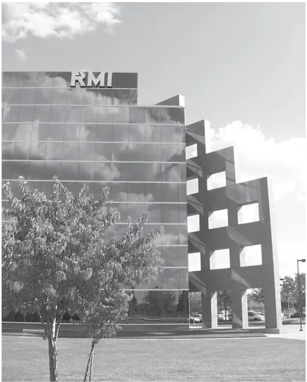
5.3.1 Recommendations
Section titled “5.3.1 Recommendations”- Support the establishment of suitable support services (e.g., day care facilities, dry cleaners, and restaurants) for employment centers to reduce the number of necessary vehicle trips.
- Provide adequate transit and shuttle services and other linkages (e.g., pedestrian crossings of Highway 50) to encourage easy and convenient access for employees of the Highway 50 Business parks to existing commercial services along Folsom Boulevard. The RMI building located within the Capital Business Center south of US Highway 50.
- Provide appropriate signalization and pedestrian crossings within existing employment centers (e.g., the Highway 50 Business Parks) to ensure the smooth flow of traffic and at the same time provide for safe pedestrian mobility.
- Support a reduction in parking for office complexes that provide aggressive transportation reduction measures, and on-site employee support services.
5.4 NEIGHBORHOODS
Section titled “5.4 NEIGHBORHOODS”With the exception of new growth areas, many neighborhoods within the Cordova planning area are aging and in need of some form of rehabilitation. There are several programs that have been created to provide assistance to existing neighborhoods. A pilot program initiated by the County Executive’s Office known as the Cordova Community Area Service Team (CORCAST) is intended to provide a communication link with neighborhoods, businesses, and organizations in the Cordova planning area. This team includes representation from a wide number of County agencies. It is hoped that this coordinated effort by the County will maximize responsiveness of services and accessibility to those services. The Sheriff is also undertaking a new program to promote the concept of ‘neighborhood policing’ whereby a community service specialist officer works closely with neighborhoods to foster greater crime prevention awareness and help in the formation of ‘Neighborhood Watch’ programs. And finally, the Sacramento Housing and Redevelopment Agency (SHRA), Sheriff, and Zoning Code Enforcement have partnered to promote better management/rental practices in South White Rock neighborhood, south of Highway 50. Additional opportunities for neighborhood assistance by the County are also possible, and are outlined in Chapter 9.
Neighborhoods can be revitalized through master planning efforts aimed primarily at commercial corridors. A recent joint City-County master planning effort was completed for a portion of Franklin Boulevard Corridor. That plan, prepared by Carter Burgess, includes several elements that help to incorporate the adjoining neighborhoods into the revitalization efforts for the commercial corridor. Themes are proposed along the commercial corridor (e.g., plantings, business names, street signs, banners etc.) that recognize and will help to establish an identity for the adjacent neighborhoods. It is possible that some of these same concepts can be promoted through the streetscape master planning effort for Folsom Boulevard that is being initiated by the County Transportation Department.
5.4.1 Recommendations
Section titled “5.4.1 Recommendations”- Work with financial institutions and state and local housing agencies to reduce the time repossessions and foreclosures are held, and explore market rehab loan programs and first-time buyer assistance programs.
- Work closely with neighborhoods, and provide assistance through the Sheriff, Code Enforcement, SHRA, and other programs such as the Cordova Community Area Service Team to improve dilapidated properties and enhance public safety.
- Provide assistance for neighborhood organizations through the Sheriff and programs such as the Cordova Community Area Service Team in the formation of homeowners associations and Neighborhood Watch programs.
- Promote the formation of new neighborhood organizations through programs such as Neighborhood Link and the Cordova Community Area Service Team in the formation of Web sites to share information such as meeting minutes, announce neighborhood events, and highlight amenities of the community.
6.0 TRANSPORTATION AND CIRCULATION
Section titled “6.0 TRANSPORTATION AND CIRCULATION”OVERVIEW
Section titled “OVERVIEW”Transportation, land use and air quality are inextricably intertwined. Land use decisions can result in reduced traffic and improved air quality. The magnitude of those changes on a projectby-project basis, however, is often hard to measure. While a much larger planning effort on a regional basis may be needed to achieve measurable improvements, it is important for the Cordova community, as one of the regional employment centers, to participate in those efforts. The intent is to strike a reasonable balance between the various transportation modes. No new roadways are recommended, but several improvements and connections are suggested that will help alleviate local circulation problems, and warrant further study to see how they may fit into a regional solution. This chapter focuses on measures that will help promote a multi-modal transportation system.
6.1 ROADWAYS
Section titled “6.1 ROADWAYS”Several new roadways will be developed within the Cordova community planning area (see Exhibit 6.1.1). Many of these roadways are shown on the General Plan Transportation Diagram such as the Hazel Avenue/Grant Line Road connection, Alta Sunrise Boulevard, a new interchange on Highway 50, and the extension of Kiefer Boulevard, and will be funded by new development. The Villages of Zinfandel, for example, is required to provide for the extension of both International Drive and Zinfandel Drive. The Mather Specific Plan and associated financing plan make provisions for the extension of Routier Road, Douglas Road, and Mather Boulevard as well. It is likely that future development such as Sunrise Douglas and Rio Del Oro will also require new roadways and/or contribute to the cost of construction of those roadways identified on the General Plan to accommodate project related traffic.
Some of the roadway improvements under construction or being discussed to address area-wide circulation problems include the addition of Diamond or High Occupancy Vehicle (HOV) lanes to Highway 50 from El Dorado Hills to Sunrise Boulevard in a joint Caltrans and County of Sacramento transportation improvement project. It is hoped that the City of Sacramento will eventually participate in this project, and continue the construction of these lanes from Sunrise Boulevard to Downtown. That section of Folsom Boulevard between Sunrise Boulevard and Hazel Avenue will be widened from 2 lanes to 4 lanes in late-2002. The Sunrise Boulevard/ Highway 50 interchange is being widened and modified. The Watt Avenue Bridge crossing the American River carries the highest traffic volume (nearly 100,000 vehicles per day in 2002) of any surface street in the unincorporated area of Sacramento County, and is being widened from 4 lanes to 6 lanes. A transportation study known as the South Watt Area Transportation Study (SWATS) has been initiated to examine a variety of possible improvements for South Watt Avenue from La Riviera Drive to Kiefer Boulevard. The first priority of the SWATS is a possible grade-separated crossing at Folsom Boulevard-either an overpass or underpass for the LRT or for traffic. Additional extension and widening of Kiefer Boulevard and White Rock Road is being considered as a way to improve circulation from east to west as well. An additional crossing of the American River is highly unlikely.
Exhibit 6.1.1: Roadway Diagram
Section titled “Exhibit 6.1.1: Roadway Diagram”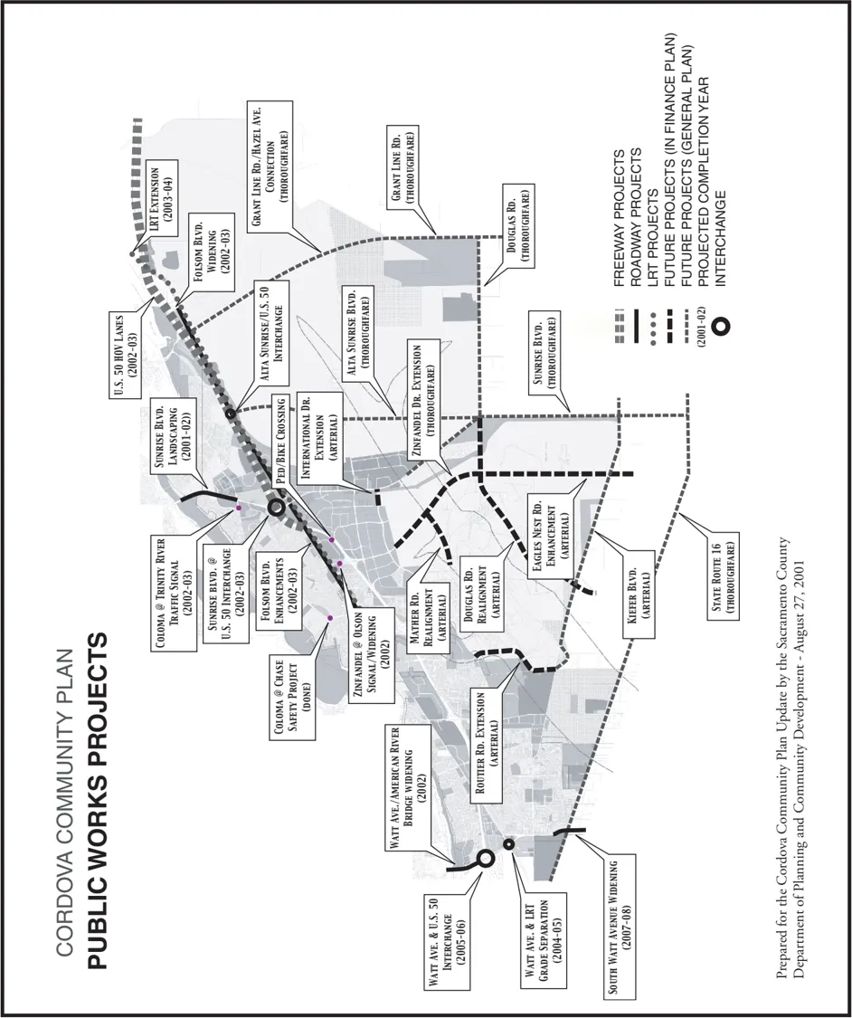
Even with the above roadway improvements, there are expected to be massive failures in the local roadway system within the coming years. The most recent data supporting this conclusion is contained in the traffic analysis for the Sunrise Douglas Community Plan/Sun Ridge Specific Plan. The EIR for that project concludes that the combined specific and community plans will generate a total of 367,900 daily trips, 28,300 AM peak trips, and 38,900 PM peak trips. While these numbers are significant, they merely compound the growing congestion problems on surface streets. The EIR indicates that under cumulative conditions, Highway 50 will operate at a LOS of ‘F’ (93,400 daily traffic volumes west of Zinfandel Drive), as well as many of the interchange ramps within the planning area. Some of the major intersections within the planning area (e.g., Sunrise/White Rock and Sunrise/Folsom), as well as portions of the major thoroughfares and arterials are also expected to operate at a LOS of ‘F’, particularly during the peak hours. Many already operate at a LOS of ‘F’ during the peak traffic hours such as Sunrise Boulevard, between the American River and Folsom Boulevard (58,100-82,600 daily traffic volume); and Folsom Boulevard, between Mather Field Road and Coloma Road (37,600 daily traffic volume). In many cases, there are no solutions as these roadways are developed to their ultimate right-of-way widths.
SACOG is exploring a parkway concept that will include a high-speed, limited-access expressway constructed on the perimeter of the urban area to link Roseville-Rocklin with Folsom, Rancho Cordova and Elk Grove. It is likely that this expressway would cross Highway 50 in the vicinity of Prairie City Road, and cross the eastern portion of the GenCorp property to link up with Grant Line Road (or a parallel facility). A similar concept in the early 1980s known as the ‘Beltway’ was met with strong community opposition. This concept would offer relief to the gridlock that is projected for the Highway 50 Corridor. In addition to community concerns, there are issues pertaining to growth inducement and environmental/open space impacts that would need to be resolved. Nonetheless, this is an opportunity that is supported by this planning process.
6.1.1 Corridor Visioning
Section titled “6.1.1 Corridor Visioning”One of the exercises conducted in conjunction with the community plan update process, was to attempt to define a vision on how each of the major streets within the planning area should function in terms of access, traffic flows, and adjacent land use during the next 10 years. Many times community planning document are often silent on the function of the major streets. The benefit to the Cordova planning area is that it is a mature community where many of these major streets have already been developed to their ultimate right-of-way widths, and the pattern of adjacent development along each of these corridors, for the most part, is established. The value of this exercise is in that it will provide a tool to help evaluate future development proposals along each of these corridors, prioritization of public works improvements (e.g., street widening, beautification and landscaped median projects), establishing traffic speeds, and in the access to and the development of adjacent subdivisions.
The following table represents the vision and recommendations for each of the major streets within the planning area. Some of these corridors exhibiting the greatest potential for improvements include Mayhew Road, Kiefer Boulevard, and Mather Field Road. It is clear that Mayhew Road (south of Highway 50) should function similar to that of a residential collector, particularly since land use along this portion of the corridor is already established. The Board of Supervisors approved a downgrade from 84 feet to 60 feet in the right-of-way for this street. Since there is ample right-of-way available for this street, a separated sidewalk and bike trail appears to be a feasible and a valued addition for adjacent residents. Any improvements to Mayhew Road should also include modifications to the Highway 50 bridge as well in order to provide safe access for pedestrians and bicyclists. There is a tremendous potential for Kiefer Boulevard to serve as the major east-west commute corridor, particularly for residents in the Rancho Murieta area, although there should be methods employed to discourage those commuters from using that portion of the corridor that runs through the Rosemont area. There appears to be ample area to add landscaping to the existing median for that portion of this street located between Watt Avenue and Mayhew Road. At Mather Field Road, on the other hand, there could be many enhancement opportunities; some of which might include a beautification project at the freeway interchange, circulation improvements to the intersection of Mather Field Road and Folsom Boulevard as well as Mather Field Road and International Drive, and the addition of a landscaped median. This street could be designed with a ‘gateway’ theme to Mather, and that there could also be greater pedestrian and bicycle linkages between the Mather Commerce Center and Folsom Boulevard.
Table 6.1.1 Corridor Visioning
Section titled “Table 6.1.1 Corridor Visioning”Watt Ave. (So. of Amer. River):
- Posted Traffic speed: 45 mph.
- Thoroughfare designation.
- 6-lanes, 108’ ROW.
- Limited access needed.
- Teichert development may change character.
- Could be a major north-south BRT route.
- Need consistent sound wall materials.
- Major commute corridor-potential conflict with commercial/retail traffic.
- Dependent on outcome of SWAT study.
- Explore slower traffic speeds for trucks.
- Add safe bicycle lanes.
- Limit driveways for Teichert development.
- Mixed-use should be encouraged near LRT station (Teichert property).
Coloma Rd.:
- Posted traffic speed: 40 mph.
- Arterial designation.
- 4-lanes, 84’ ROW.
- Character-similar to a residential collector (e.g., Mayhew Rd.).
- Limit commercial to smaller neighborhood service uses (e.g., video rental, dry cleaners, and small restaurants).
- Consider a signal at Vehicle Dr.
- Clearly designate bike lanes.
- Median landscaping needed.
- Explore options to slow traffic.
Routier Rd.:
- Posted traffic speed: 40 mph
- Arterial designation.
- 4-lanes, 84’ ROW.
- Explore south-only Hwy. 50 access.
- Character-similar to a residential collector (e.g., Coloma Rd.).
- Limit commercial to smaller neighborhood service uses (e.g., video rental, dry cleaners, and small restaurants).
Mayhew Rd.:
- Posted traffic speed: 40 mph.
- Collector designation.
- Recently downgraded, 2-lanes, 60’ ROW.
- Extra ROW available.
- Separated sidewalk needed.
- Wider (separated) bicycle lanes.
- Widen Hwy. 50 bridge for ped/bike safety.
- Character-similar to a residential collector (e.g., Coloma Rd.).
- Consider linking bike/ped access up to Amer.
- River via Mayhew Drainage Canal.
- Limit commercial to smaller neighborhood service uses (e.g., video rental, dry cleaners, and small restaurants).
- Consider extension to Jackson Road.
Kiefer Blvd.:
- Posted traffic speed: 40 mph.
- Arterial designation.
- 4-lanes, 84’ ROW.
- Median landscaping needed.
- Could be a major east-west commute corridor.
- Extend eastward, and straighten curve below Mather.
- Need consistent sound wall materials.
- Dependent upon mining reclamation.
- Improve transition for bike lanes.
Folsom Blvd.:
- Posted traffic speed: 45 mph.
- Thoroughfare designation.
- 6-lanes, 108’ ROW.
- Mix of commercial/retail traffic.
- Promote landscaped and design themes, preferably centered at LRT stations.
- Central business district at Zinfandel.
- Landscaped median needed.
- Separated sidewalk/bike path needed on south side of Folsom.
- Promote a mixed-use and pedestrian environment around LRT stations.
- Design guidelines needed.
- Explore provisions for a RT trolley similar to downtown area.
- Explore on-street parking for commercial uses (select locations) near LRT stations.
- Explore options to slow traffic at LRT stations.
Bradshaw Rd.:
- Posted traffic speed: 45 mph.
- Thoroughfare designation.
- 6-lanes, 108’ ROW.
- Look into adding access to Business Park Dr.
- Landscaped median south of Hwy. 50 is outstanding.
- Circulation improvements needed.
- Explore potential back-door truck route to Mather.
- Mix of uses-no clearly defined land use patterns.
Zinfandel Dr. (So. of Folsom Blvd.):
- Posted traffic speed: 35 mph.
- Thoroughfare designation.
- 6-lanes, 108’ ROW.
- Explore design options for Folsom/Zinfandel to discourage cut-through traffic.
- Improve Olson/Zinfandel circulation.
- Limited access needed.
- Major commute corridor, particularly for office park employees.
- Consider shuttle bus/BRT south of Hwy 50.
- Fixed land use pattern.
- Signalize intersections within business park.
Mather Field Rd.:
- Posted traffic speed: 45 mph.
- Thoroughfare designation.
- 6-lanes, 108’ ROW.
- Circulation improvements needed.
- Promote as main entrance “Gateway” to Mather.
- Beautification project needed for freeway interchange.
- Consider RR crossing of Hwy. 50 for bike/ped linkage.
- Major commute corridor-potential conflict with commercial/retail traffic.
- Landscaped median needed. Consider connecting Folsom Blvd. to Mather with use of BRT and bike/ped linkages.
- Support double-right turn access to Folsom Blvd. from northbound direction.
- Need consistent sound wall materials.
- Beautify entrances into residential neighborhoods.
Alta Sunrise:
- Posted traffic speed: Unknown
- Thoroughfare designation.
- 6-lanes, 108’ ROW.
- Consider (and reserve ROW) for future LRT station at Folsom/Alta Sunrise.
- Major commute corridor, could act to relieve traffic on Sunrise Blvd.
- Limited access needed.
- Dependent on Aerojet development, may change character.
- Construct a BRT in center landscaped median with connection to new LRT station.
- Consider link with International Dr.
Sunrise Blvd. (No. of Folsom):
- Posted traffic speed: 45 mph.
- Thoroughfare designation.
- 6-lanes, 108’ ROW.
- Major commute corridor-potential conflict with commercial/retail traffic.
- Continued pressure for strip commercial development.
- Discourage the spread of auto repair uses.
- Expand the landscaped median.
- Limit access, provide joint driveways
- Consider eliminating crossing at Albertson’s.
- Posted traffic speed: 45-55 mph.
- Thoroughfare designation.
- 6-lanes, 108’ ROW.
- Major commute corridor-character may change with addition of Alta Sunrise.
- More commercial-service uses may be needed with Sunrise Douglas.
- Better (safer) ped/bike access needed to Folsom So. Canal.
- What to do about wrecking yards? Not sure. Need to reexamine character of this corridor after development of Sunrise Douglas/SunRidge.
White Rock Rd.:
- Posted traffic speed: 45-55 mph.
- Thoroughfare designation.
- 6-lanes, 108’ ROW.
- Construct BRT in center landscaped median with connections to new LRT station.
- Might function similar to Laguna Blvd. with walls, separated sidewalks, and wide landscaped corridors.
- Extend eastward.
- Dependent on Aerojet development, and on mining reclamation; may change character.
- Limited access needed.
Douglas Rd.:
- Posted traffic speed: 55 mph.
- Thoroughfare designation.
- 6-lanes, 108’ ROW.
- Could provide bike/ped access to the Regional Park at Mather.
- Might function similar to Laguna Blvd. with walls, separated sidewalks, and wide landscaped corridors.
- Extend eastward.
- Could be a major east-west commute corridor.
- Limited access needed.
6.1.2 Neighborhood Cut-Through Traffic
Section titled “6.1.2 Neighborhood Cut-Through Traffic”As traffic volumes increase, commuters look for alternative routes that offer the least resistance. Presently, commuters seeking to avoid delays on Sunrise Boulevard use Coloma Road, Zinfandel Drive, Gold Country Boulevard, and various residential collector streets. A similar situation exists at the other end of the community planning area where commuters use La Riviera Drive to avoid delays on Watt Avenue. Traffic calming measures such as traffic circles, constrictions, curb extensions, pavement variations, speed humps could be used to help slow and/or discourage cut-through traffic, particularly on residential streets. Some jurisdictions such as Bellevue, Washington use Web sites to provide a conduit to help identify problem areas, and provide information on possible solutions. Regardless of the traffic calming measures, the County Transportation Department advises conducting a comprehensive study of a larger project area so that the traffic is not merely diverted onto adjacent neighborhood streets.
6.1.3 Recommendations
Section titled “6.1.3 Recommendations”- Explore new roadway connections within the community planning area that may help to improve area-wide circulation, and amend the General Plan Transportation Diagram accordingly.
- Encourage the construction of a high-speed, limited-access expressway (parkway concept) linking Roseville-Rocklin with Folsom, Rancho Cordova and Elk Grove, and offering relief to the traffic congestion on the Highway 50 Corridor.
- Identify a suitable transportation (truck) route from Highway 50 to Mather Airport that does not adversely impact adjacent residential neighborhoods or businesses, and improve the roadway system to accommodate truck traffic.
- Work with neighborhoods and the County Transportation Department to help identify solutions to help slow and/or discourage cut-through traffic in residential neighborhoods, and in a manner so as not to result in the diversion of that traffic to adjacent neighborhoods.
6.2 PUBLIC TRANSIT
Section titled “6.2 PUBLIC TRANSIT”One of the most likely opportunities to reduce the number of vehicle trips within and through this planning area is with the extension of LRT from Rancho Cordova to the City of Folsom. Five new LRT stations will be added within the planning area, and 3 new stations within the City of Folsom. Double tracking will also be added from Downtown to Hazel Avenue, and park-andride facilities will be added at the Sunrise and Hazel LRT stations. While it is not known precisely how many commuters may leave their cars to ride LRT, the numbers could be significant as traffic congestion increases. A recent article in The Grapevine indicates that a daily increase of at least 15,000 riders can be expected to join the system with completion of the City of Folsom link. RT also plans revisions to the bus routes within the planning area as a result of the extension of LRT. At this time, the new bus routes are not known. There are no plans to serve the Sunrise Douglas project until there is suitable residential density in place to justify that service.
Train platform at the Mather Field/Mills LRT Station.
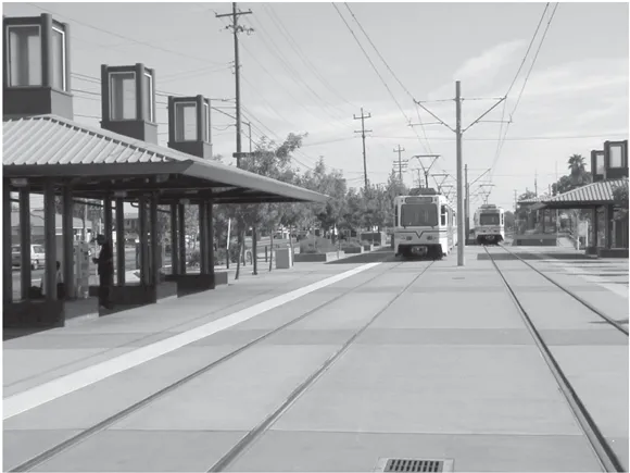
There are also opportunities for transit-supportive land use linkages adjacent to the LRT stations as discussed in Chapter 4. These opportunities are most evident at the existing Mather Field/Mills LRT station, and at the new Hazel LRT station where there is an abundance of vacant or underutilized land. The Cordova Town Center also exhibits a significant potential for intensification or additional development. An SPA has been developed to encourage transit-supportive development around each of these LRT stations. Transit-supportive development is defined as a mixed-use project, or any development that is determined to establish a linkage to public transit in such a manner to result in a reduction in the number of vehicle trips in the larger project area. A local example of a transit-supportive development might be the expansion planned for the Franchise Tax Board (FTB) and its unique relationship to the Butterfield LRT Station. The FTB expansion will add a total of 1 million square feet of office space to the existing complex, and is being designed to provide employees convenient access to adjacent light rail facilities. Support uses such as restaurants, day care and dry cleaning services will also be added to the FTB complex. Incentives are included in the SPA to encourage better design for both business and residential developments. Preferred design measures include such things as building orientation, reduced building setbacks, pedestrian amenities (e.g., outdoor cafe seating), and bicycle/pedestrian linkages.
Improvements to the transit system in terms of new bus routes and/or new vehicles will also help encourage fewer commute trips as well. RT is exploring the possibility of using smaller more energy efficient vehicles. Smaller RT vehicles similar to neighborhood commute vans are already in use in the Arden-Arcade and Carmichael communities. New public transit concepts such as those in use in Lane County, Oregon (e.g., ‘guided busways’, ‘queue jumping’, and ‘express busways’) are also being explored. The GenCorp property presents a unique opportunity to employ some of these new public transit concepts. Ideally, right-of-way dedication should provide opportunities for multi-modal transportation. New streets should be constructed from the outer boundaries (i.e., the future right-of-way line) so as to be wide enough to include a center landscaped median that can be reserved for alternative forms of transportation.
There are approximately 5 private shuttles that are either currently operating or planning to begin operation within the planning area. These services were initiated either voluntarily in an attempt to fill a void created by RT, or required to mitigate and partially off-set an anticipated significant traffic impact associated with some new development. Both the Villages of Zinfandel and Sunrise Douglas/Sun Ridge have agreed to operate their own private shuttle that would provide service to nearby employment centers and to LRT stations. It would be advantageous to coordinate the operation of these various shuttle services; and ideally, they should be operated by the local TMA (i.e., The Highway 50 Corridor TMA), as is the case in many Bay Area jurisdictions.
6.2.1 Recommendations
Section titled “6.2.1 Recommendations”- Implement a Special Planning Area, or similar mechanism, for the Folsom Boulevard Corridor that encourages and provides incentives for transit-supportive development within a 1/4-mile radius of LRT stations; as well as a pedestrian-friendly, mixed-use, multi-modal environment along the boulevard.
- Require adequate right-of-way dedication from new development to provide opportunities for multi-modal transportation, and explore policies that require initial construction of this right-of-way at the outer boundaries (future right-of-way line) so that a center median can be reserved for alternatives forms of transportation, and interim planting with landscaping.
- Encourage RT to consider Bus Rapid Transit on the Sunrise Boulevard and Alta Sunrise corridors, and reserving necessary right-of-way for an additional LRT station at the future intersection of Alta Sunrise and Folsom Boulevard.
6.3 BICYCLE FACILITIES
Section titled “6.3 BICYCLE FACILITIES”The Sacramento region is blessed with a climate that allows for bicycle commuting year round. The American River Parkway offers one of the most scenic and heavily used off-street bikeways in the region, and perhaps the entire state. The Cordova planning area offers many connections to the Parkway bikeway. Projects such as Gold River were developed with a network of pedestrian/ bicycle trails that link up with the Parkway trail at several points. In order to encourage a multi-modal transportation system that includes bicycles as a viable alternative to the use of private vehicles, a ‘complete’ network of bicycle trails must exist. That is, bicyclists must be able to safely access all areas of the community.
Off-street bicycle trail in the Gold River neighborhood.
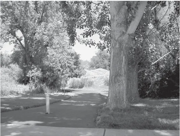
The Bikeway Master Plan is the document included in the County General Plan that identifies the existing and future improvement to that overall bicycle network. This plan shows both on and off street facilities, and is currently being update by the Sacramento County Bicycle Coordinator with the help of several bicycle advocacy groups including the Bicycle Task Force, and the Sacramento Association of Bicycle Advocates (SABA). Surprisingly, recent studies have shown that on-street facilities are actually safer that off-street facilities; particularly those with frequent crossings of public rights-of-way, as these are conflict points where accidents often occur. A list of additional improvements needed to fill in gaps in the overall network has been generated by this planning process, and includes the following improvements:
Exhibit 6.3.1: Bikeway Master Plan
Section titled “Exhibit 6.3.1: Bikeway Master Plan”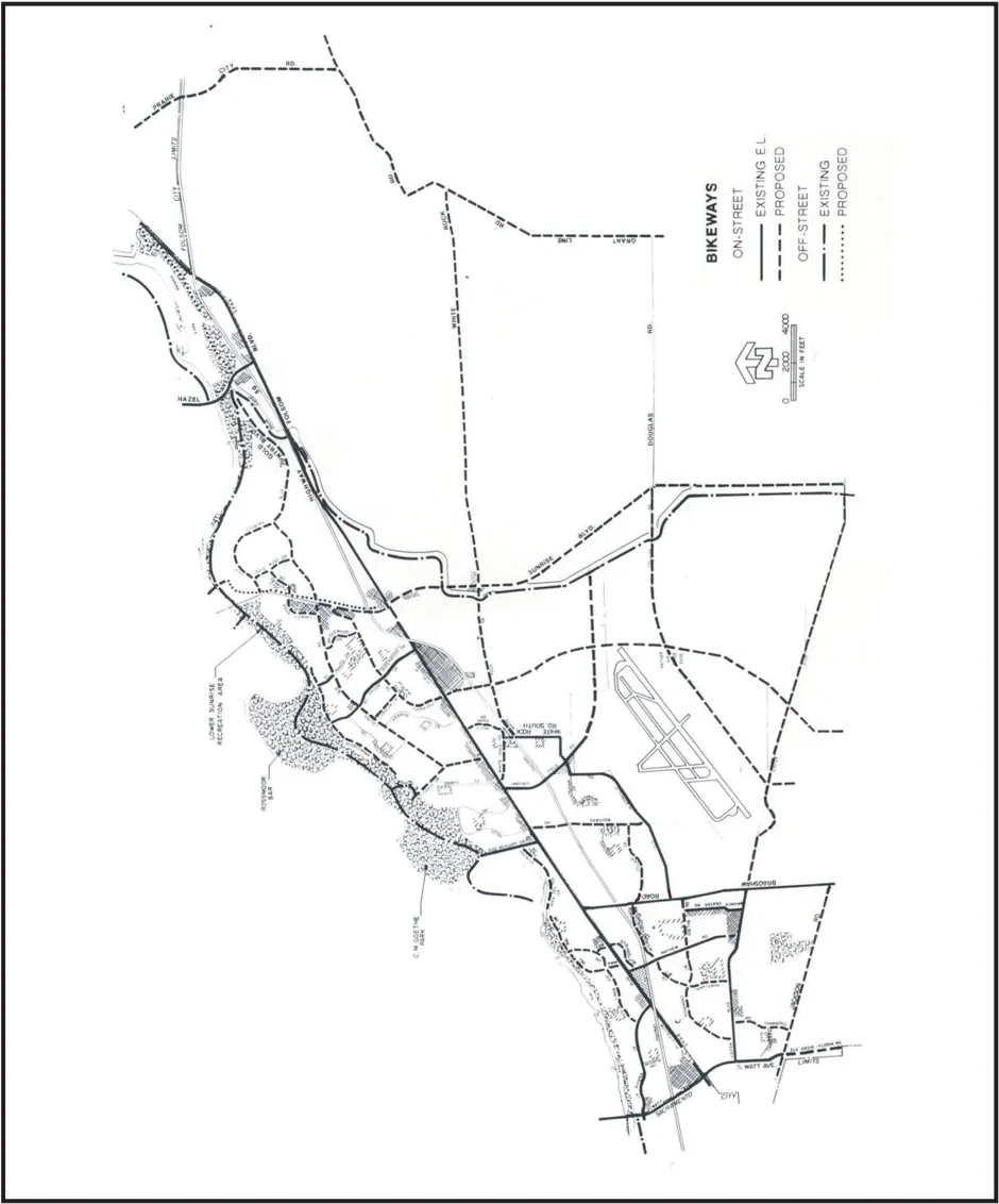
- An off-street bikeway (bike path) along the south side of the American River from Watt Avenue to the Gristmill Area (located within the American River Parkway).
- Additional off-street bikeway (bike path) crossings of the American River; in particular, in the vicinity of the Gristmill Area (located within the American River Parkway).
- An off-street bikeway (bike path) from the east end of Mira Del Rio to Rod Beaudry Drive.
- On-street bikeway along segments of Folsom Boulevard where gaps currently occur.
- An off-street bikeway (bike path) within the LRT corridor along the south side of Folsom Boulevard.
- An off-street bikeway (bike path) over Highway 50 into the Mather Commerce Center via the old railroad bridge/tracks west of Mather Field Road.
- Additional off-street bikeway (bike path) crossings of Highway 50; in particular, a link between Olson Drive and Prospect Park Drive, east of Zinfandel Drive.
- Stripe an on-street bikeway for the Mayhew overcrossing of Highway 50. Explore options to allow for the striping such as a new signal at Mayhew/Micron.
- An off-street bikeway (bike path) linking job centers at the Mather ‘campus’ to nearby housing.
- Allow the existing LRT (fenced) easement on the Sunrise Boulevard Bridge over the American River to be used by pedestrians and bicyclists.
- Provide adequate access (ramps and/or no gates) to the existing off-street bikeway (bike path) along the Folsom South Canal from adjacent public streets. Further, construct appropriate under/overcrossings of Sunrise Boulevard for this off-street bikeway for ‘through-bicyclists’ already on the bikeway.
Possible funding sources that could be used for improvements to bicycle circulation include developer fees through financing plans for both on and off-street facilities, Congestion Mitigation Air Quality (CMAQ) funding from the Transportation Equity Act (TEA) for on-street facilities, and Proposition 12 funding ($7.3 million that is earmarked for the Sacramento County Department of Parks, Recreation and Open Space) might be used to fund additional improvements within the American River Parkway. Implementation programs for needed bicycle improvements being considered include added provisions to the General Plan (e.g., a bicycle component) to promote bikeway improvements and bicycle usage, and the identification of better mechanisms for enforcing the existing bicycle regulations. RT could also assist in efforts to promote intermodal options by providing carry-on options for bicycles on buses and LRT.
Gated entry to the Folsom South Canal bicycle trail at Jackson Road.
Three improvements have been identified that would contribute significantly to the overall bicycle network in the Cordova planning area. The first, and by far, most significant improvement pertains to the Folsom South Canal and the existing trail along that alignment. The Canal and trail are owned by the Bureau of Reclamation. While this trail is noticed on the Bikeway Master Plan, as well as the Bureau’s own Web site as a ‘public’ facility for off-street bicycling, the Bureau does not actively promote public use of the trail. In fact it functions more as a service road with locked gated at each point where it provides a connection with a public street such as Sunrise Boulevard, Douglas Road and Jackson Road. It is not subject to regular maintenance or patrolled by the Sheriff. Nonetheless, numerous bicyclists use the trail by lifting their bikes over the gates. Representatives from the Sacramento County Department of Parks, Recreation and Open Space have indicated that they have been approached by the Bureau regarding the conveyance of long-term use (an easement) and maintenance responsibility. County Parks is a logical choice since the trail provides a connection with the American River Parkway and the future Regional Park at Mather. Unfortunately, County Parks does not at this time have the budget to assume these additional responsibilities.
The Folsom South Canal trail provides a valuable north-south link for this community, particularly with some of the larger developments recently approved/planned along the Sunrise Boulevard corridor. Developments such as Villages of Zinfandel and Sunrise Douglas/Sun Ridge show additional linkages to this trail. It is clear that there are certain improvements that need to be made (e.g., ramps to adjacent public streets, overcrossings for through bicyclists, open access, and regular Sheriff patrols) before this facility can safely function as a ‘public’ facility. A possible solution is developer fees that might be charged in conjunction with an infrastructure finance plan. Future development on the GenCorp property may hold the key to improvements to this bikeway as employees of office developments on the GenCorp property will find the Canal bikeway a convenient commute from those new neighborhoods to the south and southwest adjacent to the Canal.
The second important bike/pedestrian improvement identified is a potential connection following the alignment of the old railroad tracks from Folsom Boulevard to Mather, including a Highway 50 bridge located west of Mather Field Road. According to RT the Joint Powers Authority acquired the easements to these tracks in 1996 with the purchase of the right-of-way along Folsom Boulevard. However, Southern Pacific reserved the right to operate freight service on this line, and still provides an occasional freight delivery to a building materials business located between Folsom Boulevard and Highway 50. Airport Systems also has a long-term lease to these tracks in the event that operations at Mather ever warrant a railroad freight service component. While the feasibility of a bike/pedestrian connection along this alignment may not be realized for several years, it should be included on the list of preferred projects, as it would provide a direct off-street connection from the Mather Field/Mills LRT Station to employment centers and new residential neighborhoods south of Highway 50. It is possible that funding for this improvement will be available through the ‘trails-to-rails’ grant program.
The final important bike/pedestrian improvement was identified through INDEX modeling workshops for the Zinfandel LRT station area. This improvement consists of an overcrossing of Highway 50 that would connect Prospect Park Drive with Olson Drive, just east of Zinfandel Drive. This connection would provide employees of the adjacent business park area with a convenient and safe route not only to the future LRT stations, but also to retail/lunch opportunities in the Zinfandel commercial center. It should be noted that few businesses within the Highway 50 business parks provide support services for their employees; and unfortunately, these business parks were not planned with the thought of necessary commercial support services (i.e., there was never any LC or SC zoning designed for these business parks). A potential funding source for the crossing may be through the SACOG’s new Community Design Element of the Metropolitan Transportation Plan (MTP). By 2004, it is expected that approximately $500 million (phased over a 20-year period) will be available through the MTP to incentivize ‘smart growth’ private/public projects that will help reduce vehicle trip and associated air quality impacts.
6.3.1 Recommendations
Section titled “6.3.1 Recommendations”- Work with the City of Sacramento, City of Folsom, SABA, and the Bicycle Task Force to identify new bicycle improvements within the community planning area, and amend the Bikeway Master Plan accordingly.
- Work with the Department of Parks, Recreation and Open Space to identify possible funding sources (e.g., a Mello Roos or Community Service Area finance district) that would allow for the County to take possession and maintain the trail along the Folsom So. Canal as a public off-street bikeway.
- Encourage and support the design of residential neighborhoods with a network of pedestrian/bicycle trails such as those provided within the Villages of Zinfandel and Gold River.
6.4 PEDESTRIAN CONNECTIVITY
Section titled “6.4 PEDESTRIAN CONNECTIVITY”In addition to the above identified bike/pedestrian improvements, pedestrian connectivity is very important not only to promote a multi-modal transportation system, but also to create a lively and inviting streetscape, an increase in patronage for business along the Folsom Boulevard Corridor, and a health community. It is widely recognized that walking is ‘good’ for improved health. Unfortunately, much of the development that has occurred for many years in the unincorporated area encourages the use of the automobile by creating obstacles to pedestrian access (e.g., perimeter fences, heavily landscaped perimeter planters, and an abundance of parking situated between the buildings and the street). Development patterns consisting of smaller lots, as is the case for Folsom Boulevard, also promote an abundance of driveways (more driveways and fewer sidewalks) and hazards for pedestrians. Guidelines such as those included within the SPA prepared for the Folsom Boulevard Corridor will help to create a more pedestrian-friendly environment along the corridor by allowing reduced building setbacks, common parking facilities, and mixeduses. The use of INDEX modeling as described in Chapter 4 can also help evaluate walk distances between uses and to points of access such as the LRT stations, and will enhance the tools that planners have to promote pedestrian connectivity. However, the design of buildings and the layout of that development is really the influencing factor in promoting an individual’s desire to walk rather than drive.
Master planning efforts for the Streetscape Enhancement Plan that has been commissioned by the County Transportation Department will provide more specific guidelines that will influence pedestrian connectivity. It is anticipated that this planning exercise will address frontage landscaping, street furnishings such as benches, trash receptacles and lampposts. One of the more important concepts is to create a desirable and safe environment in which to walk. In many jurisdictions, it is recognized that sidewalks should be separated from the street by a landscaped buffer in order to provide greater safety for walkers. In the Sacramento region, trees are helpful to provide shade for the sidewalk. The City of Davis has constructed separated sidewalks in addition to an 8-foot wide off-street bikeway along many of its streets. RT has, in fact, already provided separated sidewalks and connections to adjacent land uses at many of the existing LRT stations along the Folsom corridor. RT has indicated that they will continue this tradition as new LRT stations are developed along the corridor.
Separated sidewalk along Folsom Boulevard, just west of the Mather Field/Mills LRT Station.
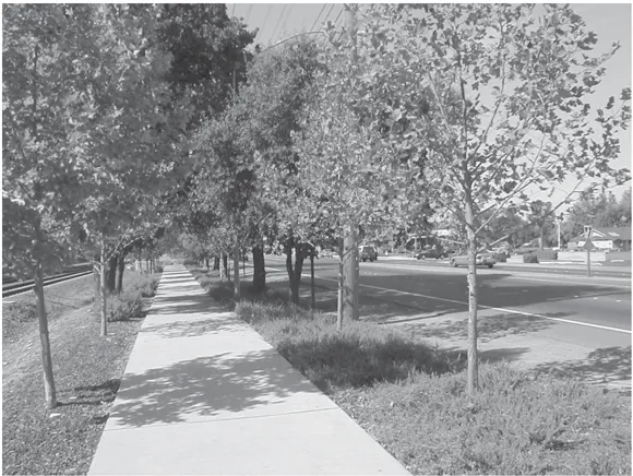
6.4.1 Recommendations
Section titled “6.4.1 Recommendations”- Support a reduction in parking and/or building setbacks to encourage LRT walk-on patronage from adjacent land uses.
- Utilize GIS-based modeling programs such as INDEX in the evaluation of various land use proposals, particularly those adjacent to LRT stations, to improve the quality of pedestrian access to public transit, and within and between land uses.
- Promote joint-use and fewer driveways for smaller parcels in order to provide additional area for sidewalks.
- Work to identify funding for the construction of separated sidewalks on the south side of Folsom Boulevard.
- Promote and encourage the construction of separated sidewalks wherever possible.
- Eliminate barriers to pedestrian/bike access (e.g., utility poles, and fencing).
- Support the installation of signals at major intersections within the Highway 50 business parks to enhance pedestrian safety.
6.5 TRANSPORTATION SYSTEMS MANAGEMENT
Section titled “6.5 TRANSPORTATION SYSTEMS MANAGEMENT”The Sacramento Metropolitan Area is a federal non-attainment area, and one of the top ten worst air quality areas nationally. The federal government has given local jurisdictions until 2005 to meet the ambient air quality standards. As a whole, the air quality within the basin appears to be improving, due primarily to the SMAQMD’s efforts, businesses’ purchases of new fleet vehicles, and improved air emissions techniques used by the auto industry. If we are not able to meet the ambient air quality standards, there is the threat that the government could cut off all federal funding for transportation improvements to this area. In the case of Atlanta, Georgia, the governor had to step in to make decisions on behalf of the local jurisdiction due to sanctions imposed for the lack of air quality conformity.
The 1993 County General Plan contains a policy (AQ-15) that requires a 15% reduction for all new major indirect sources of emissions (e.g., a use that generates a significant amount of employee or customer traffic). In fact, the SMAQMD routinely reviews and approves AQ-15 plans for larger development proposals. Unfortunately, the SMAQMD has no specific land use authority, and they merely assist local jurisdictions in the review of such plans under the authority of CEQA. These AQ-15 plans, however, are just one of the components that the SMAQMD is utilizing in its approach to address the attainment of ambient air quality standards. The 15% reduction in emissions as required by AQ-15 is really a reduction from those levels that would be produced on a base-case project assuming full trip generation; alternatively, an increase of only 85% in project emissions, rather than the full 100% which could be expected at full build-out. Some of the recent AQ-15 plans propose a greater reduction in indirect sources of emissions.
The norm is about a 30% reduction, although some plans for projects in the City of Sacramento propose reductions by as much as 70%.
The County Zoning Code specifies Transportation Systems Management (TSM) requirements for all projects, but the employee threshold that triggers the actual filing of a TSM plan is set at 500 employees and there is no clearly defined goal. In contrast, the City of Sacramento has a TSM goal to achieve a 35% reduction in vehicle commute trips. The City Zoning Code distinguishes projects by minor (fewer than 100 employees) and major (100 or more employees). For major projects, the property owner/developer is required to submit a TSM plan which shall include provisions for an on-site transportation coordinator, distribution of information to all employees on alternative commute modes, and a process for an annual report (outlining the progress toward attaining the alternative commute mode goal) to the City. There is a list of additional provisions that the plan may contain such as parking fees, transit pass subsidies, and shower and locker facilities. There is also a list of ‘credits’ that can be used toward attaining the City’s 35% trip reduction goal (e.g., a 10% credit for a vanpool program and a 2% credit for transit shelters). Unfortunately, both jurisdictions have little or no enforcement component to these TSM requirements.
Currently, there are several TSM plans approved for various projects in the Cordova planning area. While many of these plans reference a goal of a 30% reduction in employee commute trips, there are typically a wide range of TSM options available to developers, and usually not a clearly defined method for attaining the goals. Trip reduction goals often vary from jurisdiction to jurisdiction. Davis, California, for example, has established a goal of 1.5 Average Vehicle Ridership (AVR) for peak period commute trips. Bellevue, Washington, on the other hand, has a goal of a 35% reduction in Single Occupancy Vehicle (SOV) trips, and Pleasanton, California has a goal of a 45% trip reduction. The SMAQMD has indicated that a goal of a 35% reduction in SOV trips for the Cordova planning area would be realistic, but may vary based on location and access to public transit. It should be noted the Franchise Tax Board has been able to achieve a 65% reduction in employee commute trips, and it is likely that they will exceed this reduction after the expansion has been completed. It should also be noted that the SMAQMD is working on a point system (similar to the credit system used by the City) to use in the evaluation of AQ-15 plans. A system of points or credits for trip reduction provisions provided by a developer (e.g., shower and locker facilities and joining a local TMA) is much easier to administer, rather than attempting to prove through scientific research the actual reduction in vehicle emissions or in the number of vehicle trips.
A new financing tool known as a County Service Area (CSA) is being considered for large development within the planning area. Preliminary work has already been started on implementation of a CSA for TDM measures as a result of action by the Board of Supervisors in conjunction with the Villages of Zinfandel Financing Plan. A single CSA can include multiple residential, commercial and industrial properties. Property owners within the boundaries of the CSA are assessed on the basis of either number of dwellings or building square footage. The Board of Supervisors, as the governing board, appoints a third party (presumably the Highway 50 Corridor TMA) to manage the CSA. An overall goal such as a 35% reduction in peak hour travel is established by the governing board, and there are a variety of options identified for use in achieving that goal (e.g., free shuttle service, partnerships with lending institutions to offer Location Efficient Mortgages, and programs with home-builders to offer priority consideration for those employees working in the Highway 50 Business Parks), based on cost effectiveness of the options. TDM programs require a long-term commitment as well as regular monitoring and evaluation to adapt to changing conditions such as turnover in work forces, residential relocations, evolving technologies and transportation opportunities. The benefit of the CSA concept is that it can respond to these concerns by providing long-term and stable funding which has the flexibility to respond to changes that impact travel behavior.
There is significant work that still needs to occur to promote improved air quality in this region. In addition to the work that is being done by the SMAQMD, employers could offer and voluntarily implement Transportation Demand Management (TDM) programs that include, but are not limited to, the use of carpooling, flexible work hours, and telecommuting. The SMAQMD and Planning need to coordinate on how best to implement General Plan air quality strategies (e.g., simplification in the TSM and AQ-15 regulations to require a single all-encompassing implementation plan), and the CSA concept may be the tool of preference. There is also an immediate need for a ‘professional transportation coordinator’ in the employment of Sacramento County to oversee implementation of these land use regulations. Participation in a local TMA (e.g., the Highway 50 Corridor TMA) is also paramount as a means to promote a coordinated approach to multi-modal travel and trip reduction in the Cordova planning area, and such participation should be required for all businesses that meet the minimum employee thresholds set by local land use regulations.
6.5.1 Recommendations
Section titled “6.5.1 Recommendations”- Work with the SMAQMD, the Highway 50 Corridor TMA, RT, and employers to develop Transportation Demand Management (TDM) programs that include, but are not limited to, the use of carpooling, flexible work hours, and telecommuting.
- Amend the County Code to require Transportation Systems Management (TSM) Plans for all employers of 50 or more employees, achievable goals (e.g., a 35 percent reduction in vehicle trips) adequate enforcement mechanisms, and encourage membership in a local TMA (e.g., the Highway 50 Corridor TMA).
- Promote the formation of County Service Areas (CSAs) to help finance Transportation Demand Management programs.
7.0 HOUSING
Section titled “7.0 HOUSING”OVERVIEW
Section titled “OVERVIEW”Housing is a function of land use. In the case of the Cordova planning area, the supply and composition of housing has changed very little over the past decade. No new housing has been constructed for several years, but employment levels have continued to increase as the development of business parks spread along the Highway 50 Corridor. Residents have not had opportunities for ‘move up’ housing, as have other communities. Adequate improvements have not been made to the aging residential housing stock. These problems have contributed to increased traffic as people move further from the job sources in search of suitable housing. This chapter focuses on measures that will help promote an adequate supply of high quality housing to meet the needs of all segments of the community’s population.
7.1 POPULATION/HOUSEHOLD CHARACTERISTICS
Section titled “7.1 POPULATION/HOUSEHOLD CHARACTERISTICS”As of this writing, information on housing, employment and population from the Census 2000 is just starting to be made available. SACOG representatives have indicated that employment data will not be released until 2003, and projections based on the 2000 Census will not be available until 2004. Growth projections based on the 1990 Census are developed through a joint effort between SACOG and local planning departments, and are available on the SACOG Web site. This projection data is available by minor zones (small geographic areas), census tracts, cities or Regional Analysis Districts (RADs). In the case of the Cordova planning area, the ‘Rancho Cordova’ RAD corresponds to the community plan boundaries. The 2000 Census uses a new geographic reference, known as the Census Designated Place (CDP), and identifies separate CDPs for Rancho Cordova, Rosemont, La Riviera and Gold River (see Exhibit 7.1.1).
According to the Census 2000 population profile for the Cordova planning area (see Table 7.1.1), there are a total of 96,260 persons residing within the planning area. The median age of this population is slightly lower than other jurisdictions in this area, which is reflective in the numbers of those under 18 years of age and those 65 years and above. The Census 2000 housing characteristics (see Table 7.1.2) reflect a high number of rental units, particularly in the Rancho Cordova Census Designated Place (CDP); however, as a whole, rental-occupied units within the Cordova planning area is similar to other jurisdictions. A total of 37,931 dwelling units are identified for the planning area. A housing inventory survey is being conducted by the Planning Department for the update to the Housing Element, and the preliminary findings are that of this figure, about 8,600 units or 23% qualify as multifamily units (i.e., projects of 5 units and above). These preliminary findings also lend support that the ratio of housing types is very similar to other jurisdictions. Recent housing forums conducted by SHRA also support this finding. Aside from Arden Arcade, Citrus Heights and the Cordova planning area have a substantially even split in the number of multifamily units.
Exhibit 7.1.1: Census Designated Place Boundaries
Section titled “Exhibit 7.1.1: Census Designated Place Boundaries”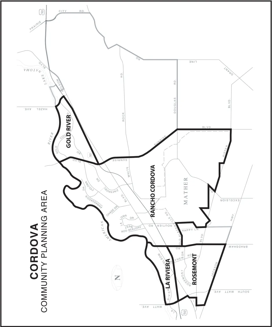
Table 7.1.1 2000 Census Designated Places (CDPs) Population Characteristics
Section titled “Table 7.1.1 2000 Census Designated Places (CDPs) Population Characteristics”| Location | Total Population | Male | Female | Under 18 | 65 and above | Median Age |
|---|---|---|---|---|---|---|
| Rancho Cordova | 55,060 | 26,897 | 28,163 | 15,620 | 5,568 | 31.9 |
| Rosemont | 22,904 | 11,259 | 11,645 | 6,212 | 1,806 | 31.1 |
| La Riviera | 10,273 | 5,119 | 5,154 | 2,038 | 1,005 | 34.1 |
| Gold River | 8,023 | 3,848 | 4,175 | 1,987 | 1,113 | 43.1 |
| Total | 96,260 | 47,123 | 49,137 | 25,857 | 9,492 | Unknown |
Source: US Census 2000.
For Comparison Purposes
| Location | Total Population | Male | Female | Under 18 | 65 and above | Median Age |
|---|---|---|---|---|---|---|
| Arden Arcade | 96,025 | 45,550 | 50,475 | 20,554 | 15,969 | 37.7 |
| Citrus Heights | 85,071 | 41,155 | 43,916 | 21,460 | 11,014 | 34.9 |
| W. Sacramento | 31,615 | 15,612 | 16,003 | 9,430 | 4,007 | 34 |
Source: US Census 2000.
Table 7.1.2 2000 Census Designated Places (CDPs) Household Characteristics
Section titled “Table 7.1.2 2000 Census Designated Places (CDPs) Household Characteristics”| Location | Total Housing | Vacant Units | Owner-Occupied | Renter-Occupied | Average Family Size |
|---|---|---|---|---|---|
| Rancho Cordova | 21,584 | 1,177 | 10,056 | 10,351 | 3.22 |
| Rosemont | 8,584 | 204 | 4,679 | 3,701 | 3.18 |
| La Riviera | 4,488 | 143 | 2,458 | 1,887 | 2.92 |
| Gold River | 3,275 | 95 | 2,834 | 346 | 2.91 |
| Total | 37,931 | 1,619 | 20,027 | 16,285 | Unknown |
Source: US Census 2000.
For Comparison Purposes
| Location | Total Housing | Vacant Units | Owner-Occupied | Renter-Occupied | Average Family Size |
|---|---|---|---|---|---|
| Arden Arcade | 44,818 | 1,831 | 20,247 | 22,740 | 2.88 |
| Citrus Heights | 34,897 | 1,419 | 19,139 | 14,339 | 3.06 |
| W. Sacramento | 12,133 | 729 | 6,218 | 5,186 | 3.39 |
Source: US Census 2000.
Table 7.1.3 Cordova Community Planning Area
Residential Building Construction
Section titled “Table 7.1.3 Cordova Community Planning Area Residential Building Construction”| Timeframe | Total |
|---|---|
| 1960-69 | 8,035 |
| 1970-79 | 13,614 |
| 1980-89 | 6,423 |
| 1990-99 | 1,941 |
Source: Sacramento County Housing Element.
Table 7.1.4 Cordova Community Planning Area
Historic Population Growth
Section titled “Table 7.1.4 Cordova Community Planning Area Historic Population Growth”| Year | Total |
|---|---|
| 1970 Census | 47,941 |
| 1980 Census | 78,968 |
| 1990 Census | 93,967 |
| 2000 Census | 96,260 |
Source: Sacramento County Housing Element.
As indicated above, the supply and composition of housing has changed very little over the past decade within the Cordova planning area. Information contained within the Sacramento County Housing Element (see Table 7.1.3) indicates that the major growth occurred in the 1970s as residential development expanded outward from what was traditionally the downtown core. Typical homebuyers of that period (the ‘Baby-Boom’ generation) were primarily first-time homeowners, and Watt Avenue was perceived as the boundary to the ‘suburbs’. With the advent of faster cars and a more well developed transportation system, these areas are now only a few minutes from Downtown, and the suburbs have been redefined as Folsom, Roseville and El Dorado Hills. Moreover, with the growth of widely spread regional employment centers and the concept of ‘Edge Cities’, it is becoming more difficult to label growth patterns in any one region as a traditional suburb. This is also reflected in the historic population growth for the planning area as well. Once again, information contained within the Sacramento County Housing Element (see Table 7.1.4) indicates that a 65% increase in population occurred during the 1970s. This is a sharp contrast with the minimal increase of only 2% that occurred during the 1990s. Residents have not had opportunities for ‘move up’ housing, as have other communities.
A lack of enforceable infill policies, the abundance of cheap land and willing sellers at the edge of the urban fringe, and development-friendly land use policies by adjacent jurisdictions have all contributed to a pattern of sprawl in the Sacramento region. This development pattern has, in many cases, left older communities static. The Cordova planning area has been one of the victims of this circumstance. Until recently, there have been few builders willing to commit to this community’s housing market.
7.2 NEW HOUSING OPPORTUNITIES
Section titled “7.2 NEW HOUSING OPPORTUNITIES”New residential projects such as Mather at Independence and Villages of Zinfandel are already under construction, and when completed, will add an additional 3,780 dwelling units to the planning area. With the new Rosemont High School under construction at Bradshaw Road and Kiefer Boulevard, the Sacramento City USD determined that they no longer need the old high school site located on Mayhew Road. As of this writing, a tentative subdivision map application is in process to divide this 36-acre site into 197 single-family lots. Sunrise Douglas/SunRidge is a 6,050-acre project with the potential for a total of 22,000 dwelling units, although only a small portion of the project is located within the Cordova planning area.
Within the planning area, the single largest development potential obviously lies in the GenCorp property, a vast expanse of property covering approximately 13,000 acres, located south of Folsom Boulevard, between the Folsom South Canal and Prairie City Road. GenCorp did not participate in the community planning process, but has stated publicly that they are exploring several options for the future use of their property. Perhaps the biggest obstacle will be the groundwater clean-up operation, and how long that process will take (see Chapter 4 for details on the groundwater clean-up efforts).
Another large-scale development proposal is Rio Del Oro, which is 3,850 acres in size, and located on the Aerojet property, south of White Rock Road. This project has a potential to add a total of 15,000 dwelling units to the planning area. A portion of that development proposal (1,100 acres) has since been purchased by Elliott Homes, and as of this writing, there are efforts underway to convert a portion of the application to 2,000 dwellings, and negotiate for the purchase of the remainder of the property subject to the original development proposal. Regardless of the ownership, the Rio Del Oro development is still in the early planning stages, and it may be years before it is approved. The availability of a safe potable water source is the primary issue.
Monument entry to Independence at Mather.
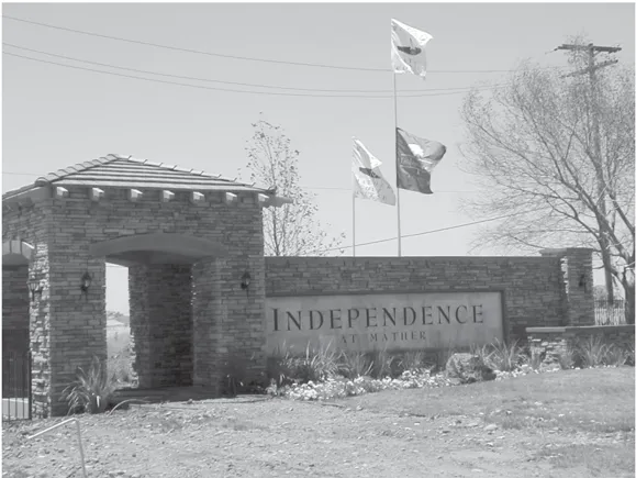
The final growth area consists of several parcels located along the Folsom Boulevard Corridor that are either vacant or exhibit a strong potential for reuse. The SPA developed for the Folsom Boulevard Corridor was initially intended as a companion document to this plan, and as an implementation tool to promote the 3 general themes-Community Identity, Revitalization and Traffic Management. A SPA, or similar mechanism, could be used to stimulate the revitalization/ reuse of existing land uses on the corridor, and promote development that will be supportive of LRT. Incentives could be offered to encourage development that is more closely related to and supportive of LRT, particularly for those areas within a 1/4-mile radius of these stations. Development standards could be crafted to permit mixed-use, and multi-story structures around each of these stations. It is conceivable that there could be hundreds, if not thousands, of additional residential units constructed along the corridor, if that type of transit-supportive development can be realized. For the most part, the larger vacant parcels along the corridor today are close to existing/proposed LRT stations, and could take advantage of the opportunities provided by convenient public transit access. Some of these parcels are surrounded by existing residential development, and have several unfinished streets stubbing their boundaries. Therefore, it will be important to balance the LRT transit-supportive and community revitalization goals, while working to ensure that these future land uses will compliment existing neighborhoods.
The above examples reflect an increasing supply of housing to help balance the tremendous demand that is generated primarily by employment in the Highway 50 Business Parks (see below). Addition housing opportunities are also possible on the GenCorp property as well as at the LRT stations along the Folsom Boulevard Corridor.
7.2.1 Recommendations
Section titled “7.2.1 Recommendations”- Implement a Special Planning Area, or similar mechanism, for the Folsom Boulevard Corridor that encourages and provides incentives for various forms of residential and mixed-use development within a 1/4-mile radius of LRT stations.
- Work with the Sheriff and Fire Prevention District to ensure that appropriate safety and crime and fire prevention measures are incorporated into all new residential developments.
- Establish policies and procedures to encourage the citing of duplexes for all corner lots in single-family subdivisions to promote a greater variation in housing types throughout the community.
- Identify ‘infill’ sites that could accommodate additional residential development, and provide incentives to prioritize development on those sites.
- Encourage the reuse of underutilized commercial property, particularly for mixed-use development.
7.3 HOUSING IMPROVEMENTS
Section titled “7.3 HOUSING IMPROVEMENTS”As indicated by the table above, the majority of the existing housing stock within this community was constructed in the 1960s and 1970s. Much of this housing was constructed as rental housing, particularly in the Rancho Cordova CDP, to cater to the military personnel stationed at Mather. That housing has not held up well over time, and there is considerable concern in this community for more appropriate maintenance and management of these units. Several community-based organizations and governmental agencies have teamed together to improve the housings through various methods. Perhaps the most visible agency is SHRA and the work they do in conjunction with their assisted housing programs. According to SHRA representatives over the last decade, they have rehabilitated 630 units of multifamily housing (cost $4.3 million), provided transitional housing at Mather (cost $12.8 million), and provided rehabilitation loans and grants for 80 single family dwellings (cost $370,000); all within the Rancho Cordova CDP.
One of the more promising new programs initiated to assist troubled neighborhoods is a program in the South White Rock Road neighborhood which consists primarily of renter-occupied duplexes. This program, initiated in 2002, is modeled after a similar program in Fairfield, California. The Sheriff, SHRA and County Code Enforcement have joined forces in an effort to educate and inform property owners in this neighborhood of various options available to them to help with property maintenance and tenant relations. A $300,000 grant for the program was obtained from the California Housing and Community Development (HUD) over a three-year term. Neighborhood workshops have been well attended, and low-interest loans have been offered for general property maintenance and improvement. It is also possible that Code Enforcement and SHRA may establish a temporary office in one of the residential structures, most likely one of those owned and undergoing rehabilitation by SHRA. The Sheriff is also involved in this pilot program, and is working closely with Code Enforcement on residential structure/property inspections. Representatives from SHRA have indicated that funding is available for ‘family housing’ construction and rehabilitation through the fees that are collected from commercial development (Housing Trust Fund). Since most of these areas that are in need of some form of assistance consist almost entirely of rental-occupied households, another funding program that is also being explored would provide financial incentives for owners of rental property to reside on-site or close by so as to have a greater stake in property maintenance/management and pride in the neighborhood.
Duplex neighborhood on South White Rock Road.
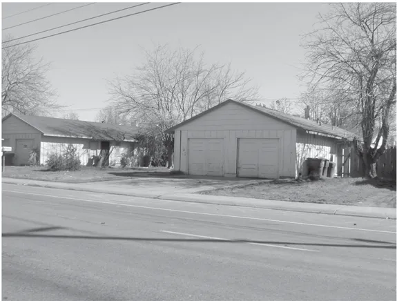
Multifamily projects are often cited as one of the most notorious examples of the lack of maintenance, and contributors to many of the community’s problems; be it increased crime and drug problems or low educational scores. The Sheriff has recently targeted some of those multifamily complexes in this community that have higher than normal crime statistics for additional police presence. Problem Oriented Police (POP) Officers have been assigned to specific complexes to work closely with management on tenant relations and discourage illegal activities by their presence. Community non-profit groups such as the Cordova Community Collaborative and Family Support Services also focus much of their efforts on residents of these multifamily complexes.
Additional assistance is also being provided by the County through a new program known as the Cordova Community Area Service Team (CORCAST). The intent of this new program is to provide a new County communication link with neighborhoods, businesses, and organizations in the Cordova planning area. This team includes representation from a wide number of County agencies. In many cases, the County has the necessary resources to help neighborhoods organize associations, create Web sites, and promote community-wide events. There are also opportunities to establish greater linkages between neighborhoods and nearby business districts (see Chapter 3). Neighborhood improvement programs such as photo contests or a ‘paint your house’ day could be sponsored by local businesses.
7.3.1 Recommendations
Section titled “7.3.1 Recommendations”- Work with SHRA, the Sacramento County Code Enforcement Section and Sheriff to identify programs to improve existing substandard housing, and create partnerships between these agencies to implement those programs.
- Work with financial institutions and state and local housing agencies to reduce the time repossessions and foreclosures are held, and explore market rehab loan programs and first-time buyer assistance programs.
7.4 JOBS-HOUSING BALANCE
Section titled “7.4 JOBS-HOUSING BALANCE”The ratio of a community’s jobs to housing is one of the most important elements to consider in a regional effort to reduce traffic congestion. As indicated by Exhibit 7.4.1, there is a significant imbalance between jobs and housing within the Cordova planning area. This data was taken from SACOG’s projections, and is based on the 1990 Census information. As noted above, SACOG will not have projections based on the 2000 Census until 2004. New housing from projects such as Villages of Zinfandel and Independence at Mather will help to balance the ratio. New projects such as Sunrise Douglas/SunRidge will also help, particularly since there will be a potential for 22,000 dwelling units within that project. Although, it should be noted that the exhibit below does not reflect additional housing from the Sunrise Douglas/SunRidge project as that project is technically not located with SACOG’s ‘Rancho Cordova’ RAD on which this graphical representation was based.
As this area has developed into one of three regional employment centers, the imbalance between jobs and housing has become more apparent. Of the three employment centers (Downtown Sacramento, Rancho Cordova, and Roseville), the Cordova community is the only one where the construction of new housing has not enjoyed the same priority as it has in other communities. As a result, there is a pent-up demand for new housing located close to employment. That pent-up demand is fueled by a growing impatience with the time spent in commute traffic, the young age of many of the professionals, and the difference in lifestyles and perceived values that is inherent to a new generation.
Exhibit 7.4.1 Cordova Community Planning Area Jobs to Housing Growth
Section titled “Exhibit 7.4.1 Cordova Community Planning Area Jobs to Housing Growth”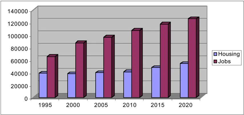
Source: SACOG projections, 1990 Census.
The benefit to some of the new residential projects in this community is that they are located close to the employment center. Villages of Zinfandel has the most direct linkage being immediately adjacent to the Capitol Center, Prospect Park and Mather Commerce Center. New roadways such as the extension of Zinfandel Drive, Mather Road and International Drive will provide direct access to these employment centers. The Villages project together with Independence and Sunrise Douglas/SunRidge all show bicycle connections to these nearby employment centers as well. Future residential development on the GenCorp property and around each of the LRT stations could be integrated with employment generating uses and/or designed to provide these types of direct linkages. Once again, the GenCorp property provides a unique opportunity to integrate development with the new LRT station at Hazel/Aerojet Road, and create a premiere example of a multi-modal transportation environment. Aside from the anticipation that there will be opportunities to work closely with GenCorp in the initial development of land use concepts for their property, it is hoped that this planning exercise will help provide the direction and vision needed to generate those concepts.
Information on the jobs to housing ratio can be somewhat deceptive, unless considered in the context of where people are working. As indicated previously, it is known that there are approximately 42,000 persons employed within the Highway 50 Business Parks, and that this number is projected to increase to 95,000 (226%) by 2020. Obviously, many of those employed within these business parks do not reside within the community. This fact is reflected in traffic/commute patterns that SACOG generates. A recent travel survey that SACOG conducted found that 53% of the population within the Rancho Cordova RAD traveled outside of the community for employment. However, this commute pattern has improved over the 73% that was identified in conjunction with the 1990 Census. This may mean that more and more people within this community are choosing to work closer to where they reside because of frustration over increased commute times, and/or may reflect the rapid rise of employment in these business parks which equates to more local employment opportunities.
The health of a local economy is based on employment diversity. As indicated above, the largest employment center is the business park along the Highway 50 Corridor where office workers constitute over one-half of the total workforce within the community. The Cordova planning area is diversifying, particularly with expansion of large governmental employers like the Franchise Tax Board on Folsom Boulevard, and the County Branch Center Complex on Bradshaw Road. The transformation of Mather will generate new industries that rely on air freight such as manufacturing and distribution businesses. The development of the GenCorp property and revitalization of the Folsom Boulevard Corridor will also help create new employment. These new industries may help balance the jobs-to-housing ratio by creating greater diversification in the workforce.
7.4.1 Recommendations
Section titled “7.4.1 Recommendations”- Work with homebuilders, the SMAQMD, and the Highway 50 Corridor TMA to explore programs whereby homebuilders would offer the opportunity for employees of nearby employment centers, particularly those employees within the Highway 50 Business Parks, advance purchase opportunities for housing in new subdivisions, employer subsidized ‘no points’ financing, and other incentives to encourage employees to relocate closer to their job site.
- Work closely with GenCorp in the initial development of land use concepts for their property to ensure that eventual development will include an adequate mix of commercial, office and housing, with appropriate linkages to nearby and/or new employment centers.
7.5 SPECIAL HOUSING NEEDS
Section titled “7.5 SPECIAL HOUSING NEEDS”Many forms of housing assistance are provided based on physical, social and economic needs. Within the planning area, DHA and SHRA are the main providers of housing assistance. It is not the intent of this planning exercise to distinguish between all of those various forms of assistance, nor to allocate additional land use or resources for that purpose. As in the case of service providers that have their own master plans, it is the intent of this plan to lend support to those efforts where feasible.
As indicated by Table 7.1.1 above, there is a significant number of the population in this planning area under the age of 18. One of the more frequent concerns is the lack of recreational opportunities for youth, particularly in the larger multifamily complexes. In many cases, these multifamily complexes do not have any recreation facilities for youth, and lack the financial wherewithal to provide those facilities. Additional efforts need to be made to help provide those recreational facilities. Alternatively, a youth center such as a Boys and Girls Club would be a benefit to this community. The Cordova Recreation and Park District is exploring several options for additional recreation youth opportunities, including the construction of a skateboard park.
There is also a growing need for senior housing. In fact, very few senior housing facilities exist within this planning area. Most, if not all, of those facilities are designed to provide care and supervision for their residents. As of this writing, there are only two senior nursing homes and a Eskaton assisted-living facility within the planning area. Independent-living facilities for seniors are needed, and that is a need that will become more obvious in the future with an aging population. These facilities should be located in the community in areas within or close to existing neighborhoods so that residents do not feel like they have to abandon their roots and lifelong friendships. The Folsom Boulevard Corridor would be an ideal location for such housing with its relationship to adjoining neighborhoods and convenient access to public transportation and shopping.
7.5.1 Recommendations
Section titled “7.5.1 Recommendations”- Work with various social service providers to identify special housing needs for the planning area.
- Work with the Sacramento Housing and Redevelopment Agency and the Sheriff to identify special needs of residents of existing multifamily complexes, particularly recreational amenities for children (e.g., basketball courts, day care, and computer access), and assist in the financing and citing of those amenities.
- Work with various human service providers and the Cordova Recreation and Park District to cite appropriate youth recreation facilities throughout the planning area.
- Work with various human service providers, the Cordova Recreation and Park District, and developers to cite appropriate senior facilities/housing throughout the planning area.
8.0 RECREATION - OPEN SPACE
Section titled “8.0 RECREATION - OPEN SPACE”OVERVIEW
Section titled “OVERVIEW”The Cordova Recreation and Park District (CRPD) has the primary responsibility for providing recreation facilities and services within the Cordova planning area. They are, in fact, the only park district that operates within the planning area, and their jurisdiction extends south beyond the boundaries of the planning area to Jackson Road and Grant Line Road. The Sacramento County Department of Parks, Recreation and Open Space is responsible for the American River Parkway along the northern boundary of the community planning area, as well as the Regional Park facilities at Mather. Both of these recreation and park providers have their own master plans, and it is the intent of this plan to lend support to those efforts where feasible.
8.1 CORDOVA RECREATION AND PARK DISTRICT
Section titled “8.1 CORDOVA RECREATION AND PARK DISTRICT”As indicated above, the CRPD covers all of the community planning area as well as a portion extending south beyond the boundaries of the planning area to Jackson Road and Grant Line Road (see Exhibit 6.1.1). Within the planning area, the CRPD owns and maintains 18 neighborhood parks, 6 community parks, 4 community swimming pools, the Cordova Community Center at Hagan Community Park on Chase Drive, the Cordova Senior Center on Routier Road, Mather Sports Complex, the Cordova Public Shooting Center on Douglas Road, and the Cordova Golf Course on Jackson Road.
There is currently no undeveloped CRPD parkland within the community planning area. Due to the method of government financing in the State since Proposition 13, maintenance of existing facilities is the biggest problem facing the District today. For over 20 years, user fees and property taxes have been the only source of funding for ongoing maintenance and repair of these facilities. As a mature community, with very little new housing and a low to moderate growth in assessed valuation, the District budget has become somewhat static. The implementation of the Education Relief Act Fund in the early 1990s, and property tax increases in subsequent years reduced the District’s income by as much as 35%. Park development in new subdivisions will be financed with some of the same tools that have been implemented by the State Legislature to provide service providers the ability to keep pace with demands from residents in new growth areas. The District has, in fact, just recently formed a Landscaping and Lighting Assessment District for the Independence at Mather subdivision, and a Community Facilities Finance District for the Villages of Zinfandel subdivision to offset maintenance and operation costs for parkland and open space facilities in these respective developments. The CRPD sponsored sports and education programs have growth, and today provide a significant source of revenue for the maintenance. Another recently approved revenue source is the Proposition 12 Park Bond, which will provide slightly over $1 million to upgrade CRPD facilities, and to replace aging equipment to comply with Consumer Products Safety Commission Guidelines and the Americans With Disabilities Act.
Exhibit 8.1.1: Park District Boundaries
Section titled “Exhibit 8.1.1: Park District Boundaries”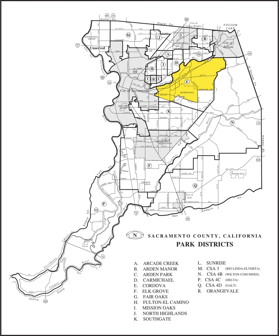
New developments such as Villages of Zinfandel, Sunrise Douglas/SunRidge, and Rio Del Oro will be required to provide either parkland dedication or in-lieu fees to be used by the District to construct an additional 27 parks over the next several years. While the Quimby Act allows for local recreation and park districts to ask for a dedication of parkland up to 5 acres per 1000 projected population, the CRPD has indicated that they have agreed to accept a slightly smaller park site in exchange for an agreement with the developer to dedicate the land and develop a turnkey park facility to the District’s approved specifications. It is also common practice with new developments to form a special assessment district to fund the maintenance and operation costs of the new parks. The CRPD estimates such costs at approximately $7,500 per acre annually, or about $76 per residential unit. The CRPD also has had a long-established policy of siting parks adjacent to schools, and entering into joint-use agreements with the respective school district. The CRPD has indicated that they will continue this practice for all newly developed areas.
As indicated in Chapter 7, the population within the community planning area is aging and becoming more ethnically diverse. There is a need to consider these characteristics in planning for recreational facilities. Some new concepts that might be explored by the CRPD include construction of additional indoor community facilities at park sites, exploring partnerships with other service providers to better manage/maintain assets, supporting the continued development of community pools, and exploring the addition of ‘special use’ gardens (ornamental, community, and arboretum) to the park system. There is also a need for collaboration and co-location of facilities between human service providers, education and recreation providers, and community organizations.
8.1.1 Recommendations
Section titled “8.1.1 Recommendations”- Work with the Cordova Recreation and Park District to identify possible funding sources (e.g., a Mello Roos, Landscaping and Lighting, or Community Service Area finance and assessment district) that would allow for addition maintenance of existing facilities, offset maintenance and operation costs of new facilities, and the installation of restrooms in all parks.
- Explore partnerships or joint-development opportunities between the Cordova Recreation and Park District and other service providers, whereby there could be joint-use of facilities as well as added supervision of park facilities.
- Work with the Cordova Recreation and Park District and various social service providers to identify new immigrant group leaders, the special recreational needs for these groups (e.g., community gardens), and possible funding sources that might be used to help finance these facilities.
- Support the Cordova Recreation and Park District in their construction and maintenance of community pools, and explore the possibility for the District to construct a ‘yearround’ community pool.
- Support the expansion of the Cordova Senior Center at the Lincoln Village Community Park, and/or construction of new senior community facilities to meet an increasing demand for such facilities.
8.2 COUNTY PARKS, RECREATION AND OPEN SPACE
Section titled “8.2 COUNTY PARKS, RECREATION AND OPEN SPACE”The American River Parkway is one of the most valuable recreation/open space assets in the region. It is a unique natural environment managed by Sacramento County Department of Parks, Recreation and Open Space (DPROS). Within the community planning area there are several points of vehicular entry to this recreation area. At the westerly end of the planning area, La Riviera Drive and Mira Del Rio Drive provide access to the SARA Park and Gristmill Dam Recreation Area. Further east, Rod Beaudry Drive provides access to Goethe Park. Rossmoor Drive and El Manto Drive provide access from Coloma Road to the Rossmoor Bar area. Sunrise Boulevard provides access to the Sunrise (upper and lower) Recreation Area. And at the easterly end of the community planning area, Hazel Avenue provides access to the Nimbus Fish Hatchery and Natoma State Recreation Area, which is managed by the State Department of Parks and Recreation as a component of the Folsom Lake State Recreation Area. Many neighborhoods also have pedestrian and bicycle access points to the Parkway; Gold River has several of these entryways.
An update of the American River Parkway Plan is currently underway, and expected to be completed in the next 2-3 years. The DPROS, Sacramento Area Flood Control Agency, and Planning Department are taking the lead on this update. To date, a River Corridor Management Plan (the first phase of the update) has been completed, and endorsed by both the Sacramento County Board of Supervisors and Sacramento City Council. This plan addresses fisheries and instream habitat management, vegetation and wildlife management, flood management, and recreation management. No new access points to the Parkway have been identified, but the plan recommends that several privately-owned parcels located east of Sunrise Boulevard (served by South Bridge Street) and historically used for commercial and quasi-industrial purposes be acquired and converted to some recreational use. Additional signage is also recommended for both Sunrise Boulevard and Hazel Avenue indicating ‘Crossing American River Parkway’. And measures are recommended to rid the Parkway of non-native invasive vegetation such as yellow star thistle.
American River Parkway near the Rossmoor Bar area.
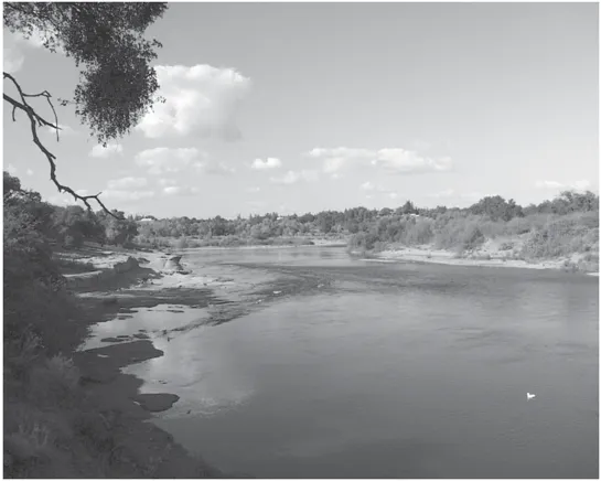
As discussed in Chapter 3, the Parkway can be used to enhance community image, and as a way to help promote a positive identity for the community. Existing recreation events and festivals such as Eppie’s Great Race and the Nimbus Salmon Festival that occur in the Parkway can be a benefit to the community in terms of positive publicity and revenues to area businesses. There could be much more done to promote the presence and access to the parkway. Many people living in this community still do not know how to get into the parkway. Larger entry or ‘gateway’ signs at the points along Folsom Boulevard and Coloma Road may help, as well as directory signs identifying the various vehicle, pedestrian and bicycle access points. And as indicated in Chapter 7, the population within the community planning area is aging and becoming more ethically diverse. There may be a need to consider various access options or recreational uses based on the changing demographic profile. A multi-cultural facility at the Regional Park planned for Mather should be considered.
8.2.1 Recommendations
Section titled “8.2.1 Recommendations”- Work with the Department of Parks, Recreation and Open Space to identify possible funding sources (e.g., a Mello Roos or Community Service Area finance district) that would allow for the County to take possession and maintain the trail along the Folsom So. Canal as a public off-street bikeway.
- Support the update of the American River Parkway Plan, and encourage participation by all segments of the population, particularly youth, seniors and new immigrant group leaders, so that special recreational/open space needs for these groups can be identified and accommodated.
- Work with the various social service providers to identify new immigrant group leaders, the special recreational needs for these groups, and consider the addition of a multicultural facility to the Regional Park planned for Mather.
- Ensure that new development provides appropriate pedestrian and bicycle linkages to existing facilities, particularly to those facilities within the American River Parkway.
- Explore various funding sources to allow Sheriff’s patrols within the American River Parkway.
- Promote the American River Parkway as a community asset, and encourage its use through additional signage, publications, and enhanced access.
9.0 PUBLIC SERVICE PROVIDERS/FACILITIES
Section titled “9.0 PUBLIC SERVICE PROVIDERS/FACILITIES”OVERVIEW
Section titled “OVERVIEW”Public services, as described herein, refer to the physical and social infrastructure that is necessary for a safe and healthy community. As indicated previously, the Cordova community planning area is a mature community, with the notable exception being the GenCorp property. Water, sewer, drainage, and energy facilities are in place to provide an adequate level of service for this existing development. Financing plans have been adopted for newly developing areas such as Villages of Zinfandel and Sunrise Douglas/Sun Ridge to cover the costs of the necessary infrastructure. The eventual development of the GenCorp property will require extensive studies on how to provide additional infrastructure as well. Groundwater clean-up from both past GenCorp operations as well as military operations at Mather are subject to ongoing studies. It is likely that these groundwater clean-up efforts will result in disruptions of traffic flows and the use of groundwater by local water district, primarily the Arden-Cordova Water District. However, the groundwater contamination and clean-up effort is beyond the scope of this document.
This chapter focuses on recent changes to facilities and the services provided by Sheriff (e.g., a new station in the community planning area), the Sacramento Metropolitan Fire District, and the Sacramento County Library. In addition, the County has embarked on a new pilot program, known as the Cordova Community Action Service Team, to interact with neighborhoods in the coordinated provision of municipal services.
9.1 SHERIFF
Section titled “9.1 SHERIFF”The Sacramento County Sheriff’s Department provides law enforcement services and police protection to the unincorporated areas of Sacramento County, including the Cordova community planning area. This includes response to calls and incidents, investigations, surveillance, and routine patrolling. Demand for services currently exceed the supply of Department resources. While Sheriff officers provide timely visits on all residential burglaries and noise disturbances, citizens are encouraged to record vandalism and vehicle burglary complaints that occur within the Cordova planning area with trained volunteers. These volunteers work at service centers located within the Rancho Cordova Neighborhood Center, at McGregor Drive and Coloma Road; and at the Rosemont Shopping Center, at Kiefer Boulevard and South Port Drive.
In an effort to ‘decentralize’ the delivery of police services, the Sheriff has recently completed a new station house on Rockingham Drive, known as the Rockingham Station, for the East Division of South Field Services. The East Division covers all of the Cordova planning area, and extends southward to Jackson Road and Meiss Road; and eastward to El Dorado County (see Exhibit 9.1.1). This new station allows for faster response times, increased crime prevention tools, more efficient service, and thus an enhanced ‘physical presence’ in the community. Volunteers also work at the station providing both walk-in and telephone reports, and vacation house-check services. Computer access to sex offender fingerprint information (Megan’s law), as well as Livescan applicant fingerprint services, a full-time crime analysis specialist, and a community meeting facility for public use is available at the station. In addition, the California Highway Patrol (CHP) has recently consummated an agreement with the Sheriff to use a portion of the station as a permanent base for several of their officers working within the planning area. The CHP provides support for vehicle thefts in addition to their duties relating to speed control on highways and local surface streets.
The Sheriff also has adopted a new policing philosophy, known as ‘community-oriented policing’. The key principles of this new philosophy are partnerships, accountability, empowerment, problem solving, service orientation and risk taking. Partnerships are reflected in joint ventures with the Rancho Cordova Chamber of Commerce such as the ‘We Mean Business’ program where area businesses pay off-duty officers to supplement the level of police service that is provided to commercial business areas. The Sheriff is also assigning specific officers to apartment complexes, neighborhoods, schools, and business districts. This philosophy allows for a closer relationship and interaction between the citizens and officers.
The Sheriff is also undertaking a new program to promote the concept of ‘neighborhood policing’ whereby a community service specialist officer works closely with neighborhoods to foster greater crime prevention awareness and help in the formation of ‘Neighborhood Watch’ programs. It is hoped that this program will also identify new immigrant groups and their safety and crime prevention needs, and establish a dialog for two-way communication.
9.1.1 Recommendations
Section titled “9.1.1 Recommendations”- Work with the Sheriff to ensure that appropriate safety and crime prevention measures are incorporated into all new developments.
- Support business-sponsored Sheriff patrol services such as Business Problem-Oriented Policing (POP) Officers and the ‘We Mean Business’ program.
- Explore various funding sources to allow additional Sheriff patrol officers, a new civilian field position known as a Community Services Specialist II (CSS II), and Sheriff’s patrols for the American River Parkway bike trail and other open space areas within the Parkway.
Exhibit 9.1.1: Sheriff’s Division Boundaries
Section titled “Exhibit 9.1.1: Sheriff’s Division Boundaries”
9.2 FIRE PROTECTION/PREVENTION
Section titled “9.2 FIRE PROTECTION/PREVENTION”The Sacramento Metropolitan Fire District provides fire protection and emergency medical response to the Cordova planning area. This Fire District was formed in 2000 by consolidation of the American River Fire District and the Sacramento County Fire Protection District. The Cordova planning area represents only a portion of the overall service area (see Exhibit 9.2.1), and includes Orangevale, Citrus Heights, Fair Oaks, Arden Arcade, Rio Linda, and South Sacramento. It is the largest fire district in Sacramento County, and currently operates a total of 41 stations (38 engine companies and 10 ambulance companies). The District recently adopted a facilities master plan that recommends the consolidation and relocation of 14 of the existing fire stations to 10 new sites over a 5-year period. Additionally, the recommendation calls for the addition of 2 new fire stations to serve areas that are currently under-served.
For that service area defined by the Cordova planning area, the District operates a total of 7 fire stations located as follows:
| Fire Station No. | Address |
|---|---|
| Station #54 | 8900 Fredrick Avenue |
| Station #61 | 10595 Folsom Boulevard |
| Station #62 | 3646 Bradshaw Road |
| Station #63 | 12397 Folsom Boulevard |
| Station #64 | 9116 Vancouver Avenue |
| Station #65 | 11201 Coloma Road |
| Station #66 | 3180 Kilgore Road |
| Station #67 | Mather Flight Line |
The master plan referenced above recommends the consolidation and closure of Stations 54 and 64, and construction of a new fire station in the vicinity of Manlove Road and Cal Center Drive. This is planned to occur sometime during the 2002/2003 fiscal year. The District has indicated that this consolidation will maintain an acceptable level of response performance, and eliminate unnecessary overlap of resources. In addition, the District proposes to add a new fire station(#68) at the vicinity of Sunrise Boulevard and Douglas Road to accommodate service needs arising from the Sunrise Douglas/Sun Ridge development. This new station is planned for construction sometime during the 2004/2005 fiscal year.
Exhibit 9.2.1: Fire District Boundaries
Section titled “Exhibit 9.2.1: Fire District Boundaries”
The District uses several mapping and modeling tools in its analysis of the distribution and concentration of resources. Under the new plan, there is an aggregate improvement in response performance from 248 to 304 zones wherein the District will provide a response time of 6 minutes or less, greater than 90 percent of the time. The Insurance Services Office (ISO) assigns a fire insurance protection classification rating to fire districts based on water supply, communications, staffing, and equipment levels. ISO ratings are intended to describe a fire district’s ability to defend against a major fire. The most common usage of the ISO rating is for setting fire insurance premiums. These ratings are on a scale of 1 to 10, with Class 1 indicating the highest levels of fire protection. Over the years, these ratings within the Cordova planning area have improved from a Class 4 in 1978, to a Class 2 today.
Financing of fire protection service is almost entirely from property tax revenues. Other sources include special tax/benefit assessments, bond indebtedness, impact/development fees, and grants. New development such as Sunrise Douglas/Sun Ridge is responsible for the full cost of additional facilities and equipment necessary as a result of that development. The revenue is typically generated through development fees established by the infrastructure-financing plan. In this case, the District has evaluated the various funding options, and believes that funding is available for Phase One improvement, ending at the conclusion of the 2003/2004 fiscal year with funds remaining in reserve. Other funding options may need to be explored for the Phase Two improvements, but it appears that the sale of surplus property can be used to make up the difference.
9.2.1 Recommendations
Section titled “9.2.1 Recommendations”- Work with the Sacramento Metropolitan Fire District to ensure that appropriate safety and fire prevention measures are incorporated into all new developments.
- Support the Sacramento Metropolitan Fire District in the citing, remodeling, consolidation, and relocation of fire stations and fire prevention facilities due to their recent reorganization.
9.3 LIBRARIES
Section titled “9.3 LIBRARIES”The Sacramento Public Library provides library services to the Cordova planning area. The only library branch within the planning area, the Rancho Cordova Library, is located at the intersection of Folsom Boulevard and Paseo Rio Way, just east of Bradshaw Road. A new LRT station, planned immediately across from this facility, at the southwest corner of Horn Road and Folsom Boulevard, will improve access for patrons.
Rancho Cordova Branch Library located on Folsom Boulevard.
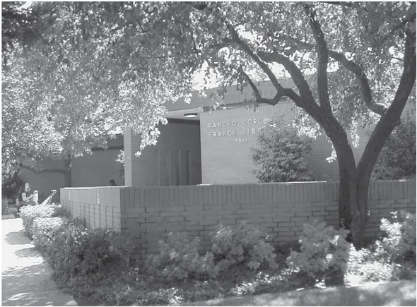
The Library just recently completed a master plan update through the year 2010. No new facilities are planned for the Cordova planning area. Surveys conducted in conjunction with this master plan update may lead to several new services for the planning area (e.g., library partnerships with local schools, Internet access to book/magazine availability, longer hours, and student computer labs). Longer hours is one of the more frequent needs identified by users. A recent ballot measure (Measure P) would have provided additional funding for new facilities and services. This ballet measure needed a 2/3-majority vote to pass, and came quite close with 66.5 percent. A nonprofit group known as Libraries For Our Future (LFOF) is planning to petition the Board of Supervisors for additional funding. Transit Occupancy Tax money may also be used to fill in the gaps. The Board may appoint a special task force to study the issue, and another bond measure is always an option.
The Library has plans to do additional outreach efforts with schools; both students and parents. Traditionally, library services are provided free of charge, but some states charge a user fee for their library services. The only fees that are currently charged by the Rancho Cordova Library are for book fines, copy services, and printing from the Internet.
9.3.1 Recommendations
Section titled “9.3.1 Recommendations”- Explore the potential for ‘satellite library’ facilities, or joint facilities in conjunction with school libraries.
- Support long-range funding and planning efforts for libraries to help identify how these facilities might better serve the community needs as they evolve over time.
9.4 MUNICIPAL SERVICES COORDINATION
Section titled “9.4 MUNICIPAL SERVICES COORDINATION”Municipal services such as animal control, traffic safety, and solid-waste disposal are very important to communities. Often times citizens are not aware of what services are available, or where to obtain access to those services. As indicated previously, the California Highway Patrol just recently stationed several officers at the new Sheriff’s facility on Rockingham Drive, and now provides services for neighborhoods in terms of traffic safety and speed control on local streets. A new program initiated by the County, known as the Cordova Community Area Service Team (CORCAST), is intended to provide a new County communication link with neighborhoods, businesses, and organizations in the Cordova planning area. This team includes representation from a wide number of County agencies. The CORCAST headquarters are located in the Rancho Cordova Neighborhood Center (RCNC), near the intersection of Coloma Road and McGregor Road. This represents the first attempt to ‘decentralize’ certain County services such as Animal Control and Planning. Various County Department/Agency representatives are available for walk-in customers at the RCNC during normal business hours. The CORCAST has also conducted workshops in various neighborhoods within the planning area to learn about important neighborhood concerns, and share information on how best to address those concerns.
This coordinated effort by the County to maximize responsiveness of services and accessibility to those services is just scratching the surface. There is much more that can be done to bridge the gap that exist between the municipal services and communities and for which they are intended to serve. Many neighborhoods hold regular association meetings, and there are various civic organization that hold monthly meetings as well. County government representation or an appointed liaison would help in this pursuit to establish better communication. As indicated above, the Sheriff has employed a community service specialist officer to work closely with neighborhoods to foster greater crime prevention awareness and help in the formation of ‘Neighborhood Watch’ programs. The Internet also provides an excellent method to disseminate information about municipal services. Jurisdictions such as Baltimore, Maryland, Bellevue and Seattle, Washington provide on their official Web sites numerous links to neighborhoods, commercial districts, and their community festivals and special events. The Sacramento City and County governments have a similar program known as Neighborhood Links.
9.4.1 Recommendations
Section titled “9.4.1 Recommendations”- Work closely with neighborhoods to identify their needs for pubic services and infrastructure, and provide assistance through programs such as the Cordova Community Area Service Team to identify and achieve methods to meet these needs.
- Work with the various service providers to identify locations where a coordinated development of a single site by multiple agencies could occur (e.g., in the case of the Rancho Cordova Neighborhood Center); and support and encourage the construction of such projects through rezones, and priority application processing.
- Work with various social service providers to identify special service needs.
10.0 HUMAN SERVICES
Section titled “10.0 HUMAN SERVICES”OVERVIEW
Section titled “OVERVIEW”Human services, previously referred to as ‘social services’, is broadly defined to include all of those community services that provide support and protection for individuals and families. These services include, but are not limited to, financial assistance, food and shelter, education services, employment and training, mental health care, substance abuse, and legal and criminal justice. The basic goal is to enable everyone to be born healthy, develop normally, and function at maximum capacity throughout a high quality life.
The Cordova planning area has many human service providers, both public and private, profit and non-profit. The two major providers are the Sacramento County Department of Human Assistance (DHA) and the Sacramento County Department of Health and Human Services (DHHS). Both of these providers have large facilities within the planning area. Other large service providers such as the Sacramento Employment and Training Agency (SETA), Sacramento County Office of Education, and Folsom Cordova USD also have facilities throughout the planning area. Smaller service providers such as the Cordova Community Collaborative, White Rock Family Center and the Family Support Services Center (previously known as the Mills Family Center) operate on grants and donations, and provide services to promote healthy children at various location throughout the community. Community service organizations such as the Cordova Community Council and Rotary also provide human services largely by donations and volunteer efforts.
In 1978, there were few human service providers, minimal coordination between these providers, and access to services was difficult. Today, there are several facilities throughout the planning area where the community can gain access to such services, and the coordination and means to identify those services is becoming easier with technology and improved public transit service.
10.1 DEPARTMENT OF HUMAN ASSISTANCE
Section titled “10.1 DEPARTMENT OF HUMAN ASSISTANCE”The Department of Human Assistance (DHA) is the largest human service provider in the planning area. The main DHA facility located is located at 10013 Folsom Boulevard, and there are currently plans to expand this facility by approximately 10,000 square feet. DHA has been working with the community and the Rancho Cordova Chamber of Commerce in the design of this expansion. There are approximately 10,000 active cases at this facility, including those associated with General Assistance/Food Stamps, Cal-WORKS, and Medical/Dental Assistance.
The primary goal of DHA is to create and carry out programs and activities that help families and individuals reach their highest potential. DHA targets clients based on zip codes established by the US Postal Service. The number of visits per day to the facility average about 200 per day, and occur between the hours of 1:30-4:00 p.m. Services provided at the Folsom Boulevard facility range from Medi-Cal, General Assistance Food Stamps, and Cal-Works. Other DHA services provided include transitional housing and training facilities at the Mather Community Campus, a Birth and Beyond program, Clinic on Wheels, a Shots for Tots clinic, and an income tax preparation assistance program. According to DHA representatives, there is currently no duplication of human services provided within the planning area.
It is unclear at this time if additional facilities will be needed to serve new growth areas such as Villages of Zinfandel and Sunrise Douglas/Sun Ridge. DHA has indicated that they look at increased demand as the population increases. It is recognized that ‘new’ facilities are difficult to cite, and the preference is to expand existing facilities. This is easier once a ‘track record’ has been established for the existing facility, and close communication is maintained with adjacent neighborhoods. As indicated previously, it is also preferable to collaborate with other agencies so as to create a ‘one-stop shop’ concept to better serve the community.
10.1.1 Recommendations
Section titled “10.1.1 Recommendations”- Work closely with neighborhoods to identify their needs for social services and in decisions to locate or expand such facilities in the vicinity of their neighborhood.
- Support the proposed expansion and remodel of the DHA facility located on Folsom Boulevard.
10.2 DEPARTMENT OF HEALTH AND HUMAN SERVICES
Section titled “10.2 DEPARTMENT OF HEALTH AND HUMAN SERVICES”The Department of Health and Human Services (DHHS) is the second largest human service provider in the planning area. At one time both DHA and DHHS was under one umbrella, but subsequently split in 1992, and now DHHS is divided into five divisions. The primary focus of the DHHS services are in the areas of senior nutrition, probate, Child Protective Services, Healthy Start, Women Infants and Children (WIC), family support clinics, and mental health. Historically, DHHS has had no planning section, but organizes around new ‘funding streams’ such as the recent Tobacco Settlement and the ability to bill Medi-Cal for reimbursement. These two revenue sources have enabled DHHS to fund new programs and services such as two new emergency response positions in the Sheriff’s Community Service Center located at the Rancho Cordova Neighborhood Center (RCNC).
Many of the DHHS services are offered at the RCNC, including, a career center, a computer training classroom, Healthy Start services, Birth and Beyond services, and Women-InfantChildren (WIC) services. DHHS views the Sheriff’s Community Service Center as a ‘partnership’ in that there is coordination with many of the services provided at this location. The fact that the Sheriff is located within the RCNC enhances the overall package of services DHHS offers at this location. DHHS has also identified a need to expand the size of these facilities; however, options are limited. Additional training opportunities as well as a possible health clinic are among the additional services that could be offered at the RCNC to meet community demands. The RCNC is one of the best examples of the ‘one-stop shop’ concept in this community.
10.2.1 Recommendations
Section titled “10.2.1 Recommendations”- Coordinate with the various social service providers to identify locations where a ‘OneStop Shop’ or a coordinated development of a single site by multiple agencies could occur (e.g., in the case of the Rancho Cordova Neighborhood Center); and support and encourage the construction of such projects through rezones and priority application processing.
- Support improved public transit to human service providers.
10.3 OTHER HUMAN SERVICE PROVIDERS
Section titled “10.3 OTHER HUMAN SERVICE PROVIDERS”Many other human service providers exist within this community. The Folsom Cordova USD provides many services related to adult education, employment training, and health care. These services are offered through Family Support Centers at many of the schools (e.g., White Rock Elementary School, Cordova High School, and Mills Middle School). The Sacramento County Office of Education (SCOE) through the Regional Occupational Program (ROP) provide employment services (e.g., training in auto mechanics, heavy equipment operations, and airfreight handling) at various locations throughout the community, including the Mather Community Campus, Teichert Construction, and Cordova High School. The Sacramento Employment and Training Agency (SETA) also provides employment services in the form of Job Club/Job Search training sessions and for CalWORKS clients at various locations including the DHA facility on Folsom Boulevard, Mather Community Campus and the RCNC. Many of these providers share office space so as to promote a ‘one stop’ concept of convenience for their clients.
The Cordova Community Collaborative is a group of local residents, schools, churches, businesses and civic organization working together to improve the health and well being of children and families in the Cordova planning area. This organization is supported primarily by grants from the Sierra Health Foundation. One of its many programs and services is to promote MediCal Healthy Families low-cost insurance, and help qualifying families sign-up for those benefits. The primary strategy is outreach and utilization of a network of community volunteers through a Child Health Advocate Program. A new computer-assisted research guide is also used to locate available human resources. Offices are located at the White Rock Elementary School (White Rock Family Center), Walnutwood School, and the RCNC.
10.3.1 Recommendations
Section titled “10.3.1 Recommendations”- Work with various social service providers to identify new immigrant group leaders, and provide assistance to such groups to identify and achieve methods to meet their needs.
- Support efforts by local businesses to train/retrain employees, sponsorships of educational programs, and internship programs through the local schools.
- Explore options to provide ‘grants’ to community-based, non-profit groups (e.g., the Family Support Services Center) for the purpose of supplementing the funding for ongoing programs.
- Provide for day care needs by implementing programs that involve a combination of volunteers, businesses, and governmental agencies.
- Support joint-use facilities whereby human services are located on campus (e.g., Cordova High School).
10.4 EMERGENCY MEDICAL CARE FACILITIES
Section titled “10.4 EMERGENCY MEDICAL CARE FACILITIES”There are many medical care facilities throughout the community. The UC Davis Medical Group has a clinic located on Olson Drive, Kaiser has a medical clinic on International Drive, Sutter has a medical clinic located on Zinfandel Drive, and there are several family support clinics at various locations. What does not exist, however, is a 24-hour emergency care facility such as that found at many hospitals in the region. The Veterans Hospital located at Mather has an emergency room, but the facility is limited to US Veterans of foreign wars. In the early 1990s, Kaiser had planned to construct a full service hospital at their International Drive location, but chose instead to construct a medical clinic/office complex. They currently own additional (vacant) property at this location, and may in the future decide to proceed with their hospital plans. The closest full-service hospitals available to the general public are Mercy Hospital located in Folsom, Sutter Memorial and Mercy General located in East Sacramento, and Sutter General and the UC Davis Medical Center located Downtown Sacramento.
It will be very difficult to attract a hospital to serve the Cordova planning area as there are so few private entities that provide this type of service, and the market itself is highly competitive. An ideal location for a hospital would be a large campus-like setting that has good access, and is convenient for patrons in terms of its location and public transit service. Many of the large vacant parcels within the planning area are impacted to some extent by aircraft overflight, and thus would preclude a hospital from the list of permitted uses. There do not appear to be any available sites that fit these criteria on Folsom Boulevard, but there are still vacant parcels in the business park south of Highway 50 that may be suitable. In addition, the 3,200-acre ‘carve out’ that Aerojet has expressed their desire to develop may also be suitable for a hospital.
10.4.1 Recommendations
Section titled “10.4.1 Recommendations”- Work with industry representatives to identify sites suitable for a full-service hospital, including 24-hour emergency room. As a general rule, these sites should be located in a campus-like setting, well served by major thoroughfares and public transit, and centrally located for patrons within the Cordova planning area.
11.0 EDUCATION
Section titled “11.0 EDUCATION”OVERVIEW
Section titled “OVERVIEW”Education in a community is widely considered one of the most important local services, and measurements of the future health and well being of its citizens. There are four (4) school districts providing public elementary through high school education that have jurisdiction within the Cordova planning area. District boundaries of the Folsom Cordova USD cover the majority of the planning area. While the boundaries for the Sacramento City USD are less extensive, extending to the Rosemont, Butterfield and Lincoln Village areas on the west side of the planning area, the number of students served within the planning area is similar to that served by the Folsom Cordova USD. Boundaries of the San Juan and Elk Grove USD also extend into the planning area. And as indicated in Chapter 10, other educational services are provided to children and adults alike by the Folsom Cordova USD, DHA and DHHS. All of these educational providers have their own master plans, and it is the intent of this plan to lend support to those efforts where feasible.
11.1 FOLSOM CORDOVA USD
Section titled “11.1 FOLSOM CORDOVA USD”As indicated above, the Folsom Cordova USD jurisdiction is the largest of any of the school districts in terms of acreage within the planning area (see Exhibit 11.1.1). Its district boundaries cover about 2/3 of the planning area. Existing enrollment within the planning area, known as the Cordova High Attendance Area (CHAA), is about 8,166 students; with 3,954 students at the elementary level, 1,783 students at the middle school level, and 2,429 students at the high school level. Facilities include ten elementary schools, two middle schools, one comprehensive high school, and one continuation high school. There is also a former elementary school (Walnutwood) which currently houses independent study, adult education and teen parenting programs; and a former elementary school (Kitty Hawk) which currently houses the Mather Youth Academy and other special programs.
The District has recently completed a comprehensive facilities master plan for the period 20002010. In this master plan, the District analyses the need for additional classrooms based on a redesign of the state school building programs due to the recent passage of the Omnibus school facilities bill (Senate Bill 50); and augmented by the approvals of additional residential development such as Mather at Independence and Villages of Zinfandel. The District projects an average enrollment increase of 186 students per year, and a need for 7 portable classrooms at the middle school level for the next 10 years within the CHAA. Most of this increase (and increase of 1,066 students) will be at the elementary level. These calculations do not include Rio Del Oro which could lead to a much greater increase in enrollment and need for additional facilities. It is anticipated that the new elementary school for Villages of Zinfandel will be complete and operational by the 2003-04 school year. The master plan also examines various funding options. For the most part, new facilities are funded by the State’s Stirling Fee that is based on square footage of new residents, and very little money comes from developer impact fees. Without additional revenue for facilities, such as a local bond measure or an increase in the developer fee assessment, the District is projecting a funding shortfall for the planning term of several million dollars.
Exhibit 11.1.1: School District Boundaries
Section titled “Exhibit 11.1.1: School District Boundaries”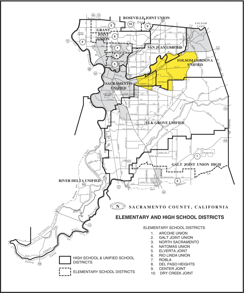
The Cordova planning area is very involved in promoting the education of its students. In 2002, a community campaign was initiated to help motivate students to improve on their SAT test scores. This campaign was known as TEAM 650, and brought together the collective efforts of civic organizations, business interests, and parents to convey to students the significance if these tests; not only for their future, but also in attaining college scholarships, obtaining additional state grants for school improvements, and in contributing to a positive community identity. These efforts resulted in numerous contributions by local businesses and an outpouring of community support, and offer an example of what is possible with a community volunteer campaign.
11.1.1 Recommendations
Section titled “11.1.1 Recommendations”- Work with the Folsom Cordova USD to locate appropriate school sites within newly developing areas.
- Encourage and support efforts by the Folsom Cordova USD and other local school districts to identify sites suitable for joint-use school/human service uses.
- Encourage the Cordova Recreation and Park District and local school districts (Folsom Cordova Unified, San Juan Unified, Sacramento City Unified, and Elk Grove Unified) to continue to enter joint-use agreements to provide for the use of school recreation facilities, including school grounds and classrooms; and support the creation of new agreements where none currently exist.
- Assist the Folsom Cordova USD to provide and cite additional classroom facilities (portables) to accommodate the projected growth within the district over the term of their master plan.
- Explore the potential for ‘satellite library’ facilities, or joint facilities in conjunction with school libraries.
- Promote local programs such as TEAM 650 where community resources, business interests and parents are brought together to help motivate students, business sponsored educational programs (e.g., computer classes), and internships through local businessschool partnerships.
11.2 SACRAMENTO CITY USD AND OTHERS
Section titled “11.2 SACRAMENTO CITY USD AND OTHERS”The Sacramento City USD boundaries cover about 1/3 of the planning area, and include Rosemont, BRECA and the Lincoln Village areas. The District is in the process of preparing a comprehensive facilities master plan for the period 2000-2010. Existing facilities within the planning area include six elementary schools, one middle school, and one high school (Rosemont High School) under construction. According to facilities planners, there is no overcrowding per se in District schools within the planning area, although plans are being made to identify options for portable classrooms. No new schools are planned for the community.
The San Juan USD boundaries cover only Gold River within the planning area. The only school within the District’s jurisdiction is the Gold River Discovery Center, a public elementary school. This school is currently at capacity, and there is no available land on which to locate portables. Any additional students generated within the Gold River development will have to be bused to District schools north of the American River.
The Elk Grove USD boundaries cover only a small portion of the southern boundary of the planning area. No schools are located, nor planned for this area. Several new schools will be constructed to serve the Sunrise Douglas/SunRidge development; however, that project is entirely within the Elk Grove USD jurisdiction.
11.2.1 Recommendations
Section titled “11.2.1 Recommendations”- Use school facilities whenever possible for neighborhood meetings.
- Encourage the Cordova Recreation and Park District and local school districts (Folsom Cordova Unified, San Juan Unified, Sacramento City Unified, and Elk Grove Unified) to continue to enter joint-use agreements to provide for the use of school recreation facilities, including school grounds and classrooms; and support the creation of new agreements where none currently exist.
- Explore the potential for ‘satellite library’ facilities, or joint facilities in conjunction with school libraries.
- Promote new concepts for providing additional classroom facilities (portables) to accommodate growth, and alternatives to bussing students.
11.3 OTHER EDUCATIONAL PROVIDERS
Section titled “11.3 OTHER EDUCATIONAL PROVIDERS”Various educational services are provided for children and adults alike by the Folsom Cordova USD, DHA and DHHS. Retraining opportunities for adults are also available through the Sacramento Employment and Training Agency, Small Business Development Center and Employment Development Department. A Business Information Center (BIC) sponsored by the Rancho Cordova Chamber of Commerce, is located within the RCNC. The BIC provides business services and workshops for employers on topic such as employee interview/screening process, marketing strategies, and cash flow analysis.
11.3.1 Recommendations
Section titled “11.3.1 Recommendations”- Work with various human service providers to identify new immigrant group leaders, and provide educational and language programs to meet their needs.
12.0 IMPLEMENTATION ACTIONS
Section titled “12.0 IMPLEMENTATION ACTIONS”OVERVIEW
Section titled “OVERVIEW”This document is intended to serve as a blueprint to guide growth and development (redevelopment) of this community over the next 10 years. Three general themes capture both the unique characters of the opportunities and challenges presented by factors such as the transformation of Mather, the extension of LRT, and the spirit of the community’s vision. These themes are often interrelated, and a positive change to one can lead to an improvement in the others as well. However, as discussed in previous chapters, additional efforts are necessary to successfully implement this plan, and carry planning efforts forward to greater detail.
This chapter provides additional information on those themes that are critical to this plan, and provides focus and guidance for future and more detailed planning efforts such as those associated with the formation of neighborhood action plans and streetscape master plans for Folsom Boulevard. These efforts should be initiated as soon as possible to capture the momentum of this planning process, and hopefully with the involvement of those same dedicated individuals that have contributed to this planning exercise.
The success of any plan is measured by its improved quality of life, including, but not limited to economic, employment, educational, cultural and environment conditions for residents and employees of this community in relation to surrounding communities, and to the Sacramento region as compared to those conditions that have historically occurred. To this end, an annual review and report to the Cordova Community Planning Advisory Council (CORPAC) is proposed. As more detailed planning efforts are completed, these can be folded into the plan to create a more dynamic document reflective of an ever-changing society.
12.1 COMMUNITY IDENTITY
Section titled “12.1 COMMUNITY IDENTITY”Promoting a positive community identity is much like a public relation campaign. Several organizations in this community (e.g., the Rancho Cordova Chamber of Commerce, and Cordova Community Council) have been very successful in promoting a positive community image. There are many areas that stand-out in this community-the Highway 50 Business Parks, the phenomenal growth of the air-cargo industry at Mather Airport, recreational opportunities associated with the American River Parkway, and new residential developments, to name a few. These form a foundation that help shape community identity. Other factors such as crime, groundwater contamination, blight are negatives that need immediate response, but can also be viewed as opportunities for communication and new friendships, better development, and to create a more desirable place in which to live, work and shop.
Sacramento County can contribute to this campaign in various ways; namely, working closely with neighborhoods, community organizations, and businesses to promote community events, commerce, and neighborhood identification through projects such as joint advertising/participation in community events, government-sponsored facade rebates, Web site development, and homeowners association formation. Many neighborhoods lack the necessary resources and knowledge necessary to organize and work toward solutions to common problems. Programs such as Neighborhood Watch or charity/fund raising drives help promote a greater sense of awareness and interest in property, the neighborhood; and more importantly, to the larger community. The Cordova Community Area Service Team (CORCAST) is just beginning to bridge that gap which exists between neighborhoods and County services. Much more coordination is possible, and with the help of the Sheriff, SHRA, Planning and the County Executives Office, partnerships can be developed that will help promote an identity which the community can be proud of.
12.1.1 Recommendations
Section titled “12.1.1 Recommendations”- Sacramento County shall designate an individual (either through the County Executive’s Office or the Department of Planning and Community Development) to work closely with various community/business organizations and neighborhoods in the promotion of matters pertaining to community identity.
- Work closely with the hospitality industry and various business interests; in particular, the Rancho Cordova Chamber of Commerce, to develop common strategies to promote a positive community identity.
- Provide assistance for neighborhood organizations through programs such as the Cordova Community Area Service Team (CORCAST) in the formation of homeowners associations, to identify solutions to residents concerns, and in the formation of Web sites to share information.
- Work closely with the Sacramento Housing and Redevelopment Agency and Sheriff to resolve matters pertaining to crime, particularly crime that occurs in or around multifamily housing complexes.
- Work with RT and landowners to develop a central plaza at the Mather Field/Mills LRT Station where community events could be staged.
12.2 TRAFFIC CONGESTION MANAGEMENT
Section titled “12.2 TRAFFIC CONGESTION MANAGEMENT”It is widely recognized that traffic is a regional problem that must be addressed on a regional basis. However, there are several measures that can be implemented locally. First and foremost, new planning concepts should be explored. The extension of the LRT line and associated stations provide an excellent opportunity to create transit-land use linkages around each of these stations. A Special Planning Area (SPA) has been developed to encourage and permit intensification of land uses at these locations along the Folsom Boulevard Corridor. Linkages can be created between housing and employment centers, as is the case with the recently approved Villages of Zinfandel project and the adjacent business parks. Mixed-use projects can provide the desired linkages themselves. Linkages can also be created at Mather for businesses such as manufacturing and distribution centers that depend on air freight service. It is hoped that development of the GenCorp property will promote linkages between uses as well. And the use of GIS-modeling programs will help planners and decision-makers effectively evaluate land use proposals.
Not only is location a factor in land use, but the design of that land use contributes to the decision to drive or not to drive. Buildings and uses should be intertwined so that pedestrian can move about with ease. Mixed-uses where commercial businesses occupy the ground floor with residential uses on the upper levels is highly desirable. Pedestrian connectivity is very important in helping create a lively and inviting streetscape, an increase in patronage for business along the commercial corridors, and a healthy community. It is unfortunate that much of the development that occurs today in the unincorporated area encourages the use of the automobile by creating obstacles to pedestrian access (e.g., perimeter fences, heavily landscaped perimeter planters, and an abundance of parking situated between the buildings and the street). Guidelines similar to those included within the SPA prepared for the Folsom Boulevard Corridor will help to create a more pedestrian-friendly environment along the corridor by allowing reduced building setbacks, common parking facilities, and mixed-uses.
Options to travel other than the private vehicle need to be maximized. Some of these options include public transportation, privately-operated shuttle services, pedestrian and bicycle connections, and carpooling. This planning exercise identified several improvements to pedestrian/ bicycle connections that could enhance community-wide circulation. The Folsom South Canal is a prime example of one such connection that could contribute significantly to overall circulation when considering the number of areas within this community that would be accessible from this north-south corridor. More efforts need to be directed to securing funding for the necessary improvements to promote alternative commute modes.
Regulatory enhancements also play a role in these efforts to reduce traffic. More aggressive Transportation Demand Measures (TDM) need to be required so that even small businesses contribute to the traffic reduction. Programs such as flexible work hours, telecommuting or a reduced workweek (i.e., a 9/80-workweek) need to be implemented on a much wider scale. Many times all that is needed is to provide RT and Rideshare materials to employees so that they are aware of the alternatives. The Highway 50 TMA is a wealth of information on alternative commute modes, and works in concert with the SMAQMD in many cases to promote rebates on the purchase of bike lockers, transit passes and the like. Mandatory participation in such a coalition will ensure that all employees are bettered informed of their options.
12.2.1 Recommendations
Section titled “12.2.1 Recommendations”- Work with the SMAQMD, the Highway 50 Corridor TMA, Regional Transit and employers to develop Transportation Demand Management programs that include, but are not limited to, the use of carpooling, flexible work hours, and telecommuting.
- Explore new roadway connections within the community planning area that may help to improve area-wide circulation, and amend the General Plan Transportation Diagram accordingly.
- Work with the City of Sacramento, City of Folsom, SABA, and the Bicycle Task Force to identify new bicycle improvements within the community planning area, and amend the Bikeway Master Plan accordingly.
- Work with the Department of Parks, Recreation and Open Space to identify possible funding sources (e.g., a Mello Roos or Community Service Area finance district) that would allow for the County to take possession and maintain the trail along the Folsom So. Canal as a public off-street bikeway.
- Amend County Code to require Transportation Systems Management (TSM) Plans for all employers of 50 or more employees, adequate enforcement mechanism, and encourage membership in a local TMA (e.g., the Highway 50 Corridor TMA).
- Require adequate right-of-way dedication from new development to provide opportunities for multi-modal transportation, and explore policies that require initial construction of this right-of-way at the outer boundaries (future right-of-way line) so that a center median can be reserved for alternatives forms of transportation, and interim planting with landscaping.
- Support a reduction in parking and/or building setbacks to encourage LRT walk-on patronage from adjacent land uses.
12.3 REVITALIZATION
Section titled “12.3 REVITALIZATION”Revitalization of the Folsom Boulevard Corridor is one of the major concerns in this community. Efforts are currently underway by several groups, and focus on landscaped median improvements, pedestrian safety, and facade improvements along the corridor. A specific master planning effort is expected with the streetscape beautification/enhancement project by the County Transportation Department and City of Rancho Cordova. The extension of LRT and the associ- ated stations will create opportunities for new development. Recently constructed projects such as the Wal-Mart/Safeway, KFC and the Baskin Robbins will encourage similar reuse or redevelopment of existing commercial centers. Many commercial facades have also been completed which has helped the corridor take on a new appearance. It is hoped that a SPA, or similar mechanism, with its primary focus on ‘revitalization’ will lend support to these efforts. Additional efforts could be directed to identifying and promoting ‘infill’ development through various financial sources provided either by the County Economic Development Office or SHRA. The City of Sacramento is currently pursuing land use strategies related to infill development, and it may be possible to adopt a similar program for Folsom Boulevard.
Dixieanne Neighborhood Action Plan, prepared by the City of Sacramento in 1999.
There are also efforts underway to revitalize residential neighborhoods. One such example is the program that SHRA, Code Enforcement and the Sheriff are conducting in the South White Rock Road neighborhood. A new pilot program initiated by the County Executive’s Office known as the Cordova Community Area Service Team (CORCAST) is intended to provide a communication link with neighborhoods, businesses, and organizations in the Cordova planning area. This team includes representation from a wide number of County agencies. It is hoped that this coordinated effort by the County will maximize responsiveness of services and accessibility to those services. Much more can be done to help residential neighborhoods, and the County has the resources and knowledge to provide the necessary assistance. The City of Sacramento has embarked on a new program to develop Neighborhood Action Plans where various representatives of the City government and City agencies sit down with the various neighborhoods and help to identify solutions to their problems (e.g., junk vehicles, speeding cars, and lack of sidewalks or streetlights), and in some cases available funding and a timetable to provide the necessary improvements as in the case for public works projects. Thus far, plans have been created for the Tahoe Park, Colonial Heights, and Dixieanne neighborhoods. This micro level of planning is the very type of assistance that is needed within the Cordova planning area.
12.3.1 Recommendations
Section titled “12.3.1 Recommendations”- Adopt a Special Planning Area (SPA), or similar mechanism, for the Folsom Boulevard Corridor that will provide greater flexibility in uses and development standards; guidelines for architecture, signs, and transit-supportive development; and local design review for all development along the boulevard.
- Work with neighborhoods to coordinate ‘infill’ planning efforts with community development/revitalization goals, and ensure that these future land uses will compliment existing development.
- Support the joint County Transportation Department/City of Rancho Cordova streetscape beautification/enhancement project for Folsom Boulevard, and encourage similar improvements for Coloma Road.
- Work closely with neighborhoods, and provide assistance through the Sheriff, Code Enforcement, SHRA, and programs such as the Cordova Community Area Service Team to identify solutions to residents concerns.
- Develop a program to work with neighborhoods in the identification and to solution of concerns, and in the preparation of Neighborhood Action Plans that outline specific strategies, participating governmental agencies/private organizations, and timing for resolution of the common problems.
12.4 NEXT STEPS
Section titled “12.4 NEXT STEPS”This section details some of the major opportunities that are envisioned over the next 10 years. Obviously, the development opportunities associated with the Aerojet property are too numerous to mention. It will be critical to work closely with GenCorp in the initial development of land use concepts for their property to ensure that that eventual development will be integrated into the community. It is possible that area-wide circulation problems can be addressed given the vastness of this property. There is also a significant opportunity to capitalize on the location of the new LRT station at Aerojet Road and provide a pedestrian-oriented, mixed-use, multi-modal transportation environment surrounding this new station. This is an opportunity that exists nowhere else in the community, nor unincorporated areas, because of the lack of existing development and vastness of this property.
Folsom Boulevard and the new LRT stations present a unique opportunity to create transit-land use linkages, similar to those that are created in an urban core area. These stations are significant in that they constitute the only access points to the region’s huge investment ($millions), they offer major opportunities to create a multi-modal transportation environment, they represent the potential for a community-wide reduction in vehicle trips and air quality improvements, and they create concentrated activity centers with economic and social benefits for adjacent residents. These are opportunities that must not be squandered.
As indicated previously, a SPA was developed for the Folsom Boulevard corridor during the community plan process, and was originally intended as a companion document to the plan. One of the important concepts to the draft SPA for the Folsom Boulevard Corridor is that incentives are critical to encourage land uses along the corridor. Many of the financial incentives outlined in the draft SPA were intended to apply to ‘revitalization’ as well as to ‘Transit-Oriented’ uses; however, many of these incentives have not yet been approved, and may have implications that extend far beyond the Cordova planning area. For example, Sewer Connection Credits could cost jurisdictions millions of dollars in lost revenues, and a strategy that would need to be approved by all of the jurisdictions that participate on the regional board; and for this reason would most likely need to be considered in the context of the General Plan Update. A broad range of incentives is still possible (e.g., reduced Road and Transit fees, and state and federal grants such as CDBG, TEA-21, CMAQ and the HCD Jobs-Housing Balance), if the importance of achieving an urban form that truly is a pedestrian-oriented, mixed-use, multi-modal transportation environment is recognized and supported by decision-makers. Once again, it is likely that this will be a strategy that has to be more regional in nature, and likely established by or in conjunction with the work that SACOG is currently doing to address important regional transportation and land use issues.
The community plan update was undertaken on the basis of the entirety of the planning area, without acknowledgment or anticipation of any new jurisdictional boundaries. On July 1, 2003, when the Rancho Cordova incorporation officially takes effect, there will be areas outside of the new city boundaries such as Gold River and Rosemont that will be regulated by this planning document. It is assumed that there will not be any significant land use changes imposed by a new city. The benefit to the Cordova Community Plan is that both jurisdictions will be able to coordinate on common strategies set forth in the plan, particularly those pertaining to Folsom Boulevard. In the case of Folsom Boulevard, consistency will be paramount as portions of this street will remain in the unincorporated area, much like Stockton Boulevard in South Sacramento, and several new LRT stations are proposed to be located near the city boundaries. In addition, the plan can provide a greater sense of unity for neighborhoods, many of which are already divided by school districts or major arterials.
12.4.1 Recommendations
Section titled “12.4.1 Recommendations”- Develop an package to provide financial incentives that would help encourage infill development, revitalization efforts, and linkages between LRT stations and adjacent land uses, particularly within a 1/4-mile radius of the LRT station; as well as a pedestrianfriendly, mixed-use, multi-modal environment along the boulevard
- Develop urban design and architectural guidelines through master planning efforts for the Folsom Boulevard Corridor that encourage pedestrian-friendly and human-scale development.
- Utilize GIS-based modeling programs such as INDEX in the evaluation of various land use proposals, particularly those adjacent to LRT stations, and alternative courses of action in the project analysis and recommendations.
- Work closely with GenCorp in the initial development of land use concepts for their property to ensure that that eventual development will be integrated into the community, recognize the area-wide circulation problems, and capitalize on the opportunities for a pedestrian-oriented, mixed-use, multi-modal transportation environment presented by the new LRT station at Aerojet Road.
- Encourage Regional Transit to consider Bus Rapid Transit on the Sunrise Boulevard and Alta Sunrise corridors, and reserving necessary right-of-way for an additional LRT station at the future intersection of Alta Sunrise and Folsom Boulevard.
- Report annually to CORPAC on the implementation and effectiveness of the Cordova Community Plan, and any additional planning efforts that might be initiated to supplement the plan.
- The County of Sacramento and City of Rancho Cordova shall work together to implement strategies outlined in the community plan, particularly those pertaining to Folsom Boulevard; the revitalization/beautification of the corridor, and establishing land usetransit linkages at the LRT stations.