West Auburn Blvd SPA
Sacramento County Zoning Code
West Auburn Boulevard Special Planning Area Ordinance and Streetscape Master Plan
Section titled “Sacramento County Zoning Code West Auburn Boulevard Special Planning Area Ordinance and Streetscape Master Plan”Adopted August 13, 2008
Adopted by ZMA #5574 / 2006-CZB-ZOB-0695
Acknowledgements
Section titled “Acknowledgements”This Streetscape Master Plan and Special Planning Area Ordinance results from a dedicated effort by community members, business leaders, key stakeholders and staff from Sacramento County and the Sacramento Housing and Redevelopment Agency who worked with a multi-disciplinary Consultant Team to articulate a vision that will create a distinctive character and guide future development along West Auburn Boulevard.
Sacramento County Board of Supervisors
Susan Peters, Supervisor, District 3
Howard Schmidt, Chief of Staff, District 3
Sacramento Housing & Redevelopment Agency
Donna Melendez, Management Analyst, Community Development
Tim Padden, Redevelopment Planner, Community Development
County of Sacramento
Troy Givans, Senior Planner, Department of Economic Development & Intergovernmental Affairs
West Auburn Boulevard Project Area Committee
Vince Maita, Maita Toyota
Macell Millard, Secretary, Auburn Boulevard PAC
Michael Salazar, Salazar’s Dance Studio
West Auburn Boulevard Stakeholders
Tim Cahill, Fulton Avenue Business Association
Mike Davis, Niello Audi
Randy Graham, Fulton Avenue Association; Braley & Graham Buick
Roy Imai, Fulton-El Camino Park District
Skip Maggiora, Skip’s Music
Jack McKinney, Deseret Industries
Ruben Meeks, Sacramento County Sheriff’s office
Michael Seaman, Fulton-El Camino Park District
Amrik Singh, Hampton Inn
Fred Usher, Clarion Hotel
West Auburn Boulevard Technical Advisory Committee Sacramento County
Christoph Dobson, Municipal Services Agency
Bobbe Dworkis, Neighborhood Services
Catherine Hack, Environmental Review & Assessment
Stephen Moore, Regional Sanitation District 1
Mark Rains, Municipal Services Agency
Jim Schubert, Transportation
Dan Shoeman, Transportation Tricia Stevens, Planning
Stephen White, Transportation
California Department of Transportation, District 3
Alyssa Begley
Barbara Procissi
Consultant Team
The HLA Group, Landscape Architects & Planners
Mark Thomas & Company, Inc., Engineering and Surveying
Fehr & Peers, Traffic Consultants
Wade Associates, Urban Planning & Design
Executive Summary
Section titled “Executive Summary”The West Auburn Boulevard Special Planning Area Ordinance and Streetscape Master Plan are intended to guide land use and development along West Auburn Boulevard in a manner that will strengthen the Boulevard’s market position as a positive business address. The Special Planning Area Ordinance offers specific recommendations to encourage private development. The Streetscape Master Plan portion of this document focuses on the public right-of-way. Together, these documents contain a road map for the revitalization of a major regional commercial district.
The goals of the West Auburn Boulevard Special Planning Area Ordinance (SPAO) and Streetscape Master Plan (SMP) are to
- Create a strong, recognizable community identity;
- Provide a safer and more effective environment for pedestrians, bicyclists, motorists, and business owners;
- Increase visibility to West Auburn Boulevard from passing traffic on the Capital City Freeway (also known as Business Loop 80);
- Promote infill and commercial development by supporting existing businesses with business improvement projects;
- Recommend land uses, policies and improvements that will encourage a variety of business ventures and strengthen the competitiveness of the Plan area;
- Strengthen urban form by providing an enhanced edge to the Arden-Arcade community; and
- Reinvest in retail and service components that service the regional and local communities.
This document sets clear goals for future development that will make West Auburn Boulevard more competitive to receive future funding for proposed improvements.
The initial step in developing the SPAO and SMP was to conduct a site inventory and analysis. Site data from aerial photographs, fi eld observations and measurements were collected, and site photos were compiled. Background research included traffic calming measures and previous studies of other street beautification projects in the County of Sacramento.
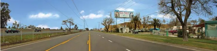
Current Conditions
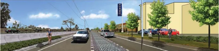
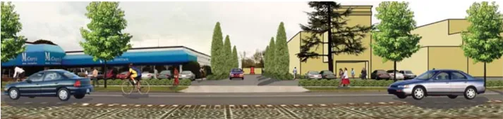
Proposed Improvements
After a number of preliminary design concepts were developed and design review meetings were held, a variety of conceptual plans were presented to community leaders and residents at public workshops and charettes. Community members were invited to ask questions and provide feedback on the concepts. Their responses were then incorporated into a Draft Concept Plan.
The Draft Concept Plan combined feedback obtained through public workshops from the community, stakeholders and the Technical Advisory Committee. The Draft Concept Plan was presented at a second charette, where community members provided additional feedback that was incorporated into the SPAO and SMP detailed in this document.
Primary components of the Special Planning Area Ordinance:
Section titled “Primary components of the Special Planning Area Ordinance:”- Form-based regulations;
- Upgrade of design quality;
- Optimize use of corner parcels and available sites as ‘neighborhood gateways’;
- Establish a theme identity;
- Create safe connections to transit stops;
- Upgrade the connection to Haggin Oaks Golf Course;
- Establish pedestrian connections to adjacent neighborhoods.
Current Conditions
Proposed Improvements
Primary components of the Streetscape Master Plan:
Section titled “Primary components of the Streetscape Master Plan:”- ‘K-rail’ separation between Caltrans and Boulevard rights-of-way;
- Strategically located raised and planted medians;
- Decorative paving;
- Public art;
- Consistent separated sidewalks and upgraded bus stop facilities;
- Bike lanes;
- Landmark and monument signage;
- Utility undergrounding;
- Emphasis on ‘neighborhood gateway’ intersections;
- Consistent right-of-way tree and ground plane plantings;
- Regular maintenance operations.
SECTION ONE: Introduction to the Plan Area
Section titled “SECTION ONE: Introduction to the Plan Area”Section One summarizes the history and existing conditions along West Auburn Boulevard, as well as the pattern of land use and development that has characterized the Plan area. The public input process undertaken to create the West Auburn Special Planning Area Ordinance and Boulevard Streetscape Master Plan is also detailed.
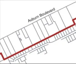
Auburn Boulevard today
A. Plan Area
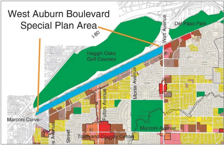
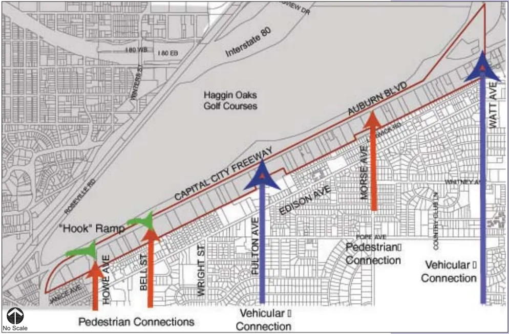
Section titled “A. Plan Area”The West Auburn Plan area comprises 118 acres within both the City and County of Sacramento. The two-mile commercial corridor fronts Interstate Business Loop 80 or Capital City Freeway. The Boulevard extends through Sacramento County from the west edge of the Plan area to Placer County. The Plan area is immediately south of the Capital City Freeway, between the Marconi Curve on the west and Watt Avenue on the east. A Caltrans right-of-way abuts Auburn Boulevard on the north. The Special Planning Area Ordinance (SPAO) and the Streetscape Master Plan (SPA) address the street and properties along the south side of the Boulevard. Due to its length and the potential for other projects elsewhere along Auburn Boulevard, this project is referred to in this document as the West Auburn Boulevard Special Planning Area Ordinance and Streetscape Master Plan.
The Plan area was designated as the Auburn Boulevard Redevelopment Area by the Sacramento Housing and Redevelopment Agency (SHRA) in October 1992. In response to extensive physical, economic and social deterioration, the Agency successfully partnered with other agencies to address health and safety issues affecting the Boulevard. Since the
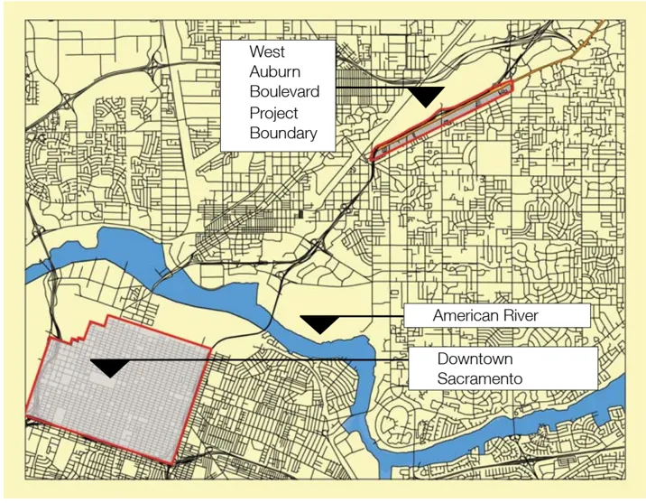
West Auburn Boulevard Context Map
Redevelopment Area was established, crime and other vices have been substantially reduced in the area, infrastructure has been overhauled, and new investment has occurred along the Boulevard.
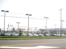
Freeway accessibility and visibility are key assets for West Auburn Boulevard properties. Four freeway ramps provide immediate access to the Boulevard. Lots that front the Boulevard tend to be narrow and deep. Although the depth allows for ancillary uses to the rear of the properties, their narrowness impedes high impact development along the street front, which would benefit from increased visibility. Parcel assemblage is encouraged to provide additional width and greater flexibility for re-use and design.
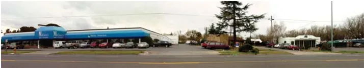
Further challenges for redevelopment include inadequate public improvements such as unsightly freeway barriers, missing or deteriorating sidewalks, insufficient landscaping, and poorly maintained housing. Notwithstanding these challenges, general and light commercial uses such as auto dealerships, furniture stores, auto service centers, and hotels have been successfully attracted to the Boulevard. These land uses contribute to the Plan area’s positive image and bright prospects for future redevelopment.
The Plan area currently is experiencing a period of significant transition. The older, highway service-oriented businesses, such as older lodging facilities, mobile home parks, and a scattering of highway-oriented restaurants will be replaced in time by emerging retail and service businesses that relate to the larger community. These uses will benefit from freeway visibility, but will no longer depend solely on the patronage of long distance travelers. In time, the Boulevard will become a retail and service center serving the regional and local communities.
B. Background Reports and Resources
Section titled “B. Background Reports and Resources”To prepare this Report, the following documents were consulted:
- 2010 Sacramento City/County Bikeway Master Plan (1993)
- Sacramento County Pedestrian Design Guidelines - Draft (2005)
- Sacramento Housing and Redevelopment Agency Auburn Boulevard Community Redevelopment Area Implementation Plan (2005-2009)
- Sacramento County Best Practices for Complete Streets (2005)
- Sacramento County Best Practices for Bicycle Master Planning and Design (2005)
- Auburn Boulevard Redevelopment Area Community Plan Amendment, Rezone, and Use Permit FEIR (1996).
West Auburn Boulevard Special Plan Area
C. Site History and Background
Section titled “C. Site History and Background”The West Auburn Boulevard Corridor forms the north edge of the ArdenArcade Community, which encompasses about 13,000 acres or 21 square miles. The area was part of the Rancho del Paso land grant, which was obtained by James Ben Ali Haggin circa 1860. Haggin bred thoroughbred racehorses on the ranch before selling the property in 1910 to the Sacramento Valley Colonization Company, which intended to subdivide the land. Much of Arden-Arcade began to develop in the 1940’s coincident with the construction of Town and Country Village (the first suburban shopping center in Northern California). Most of the population growth in the area occurred between the 1950’s and 1970’s, when an estimated 75% to 80% of the community was developed with suburban uses. Arden-Arcade is now one of the most intensely developed areas of Sacramento County.
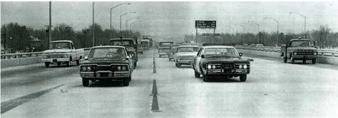
Business 80/Capital City Freeway - Opening Day
Another notable characteristic of the Plan area is the former role of the Boulevard as a link in the first trans-continental highway. Highway 40 also called the Lincoln Highway, stretched from San Francisco to Chicago and provided a key link in the nation’s transportation network. Although replaced by the current State Route 51 (the Capital City Freeway) on the north side of the Boulevard, the Plan area retains many elements of that earlier era, most notably in the older motels and traveler’s rests scattered along the Boulevard. Elements of this historical highway provide a potential theme for the design of features and landscaping along the Boulevard.
An interesting characteristic of the community is that the major streets that cross Auburn Boulevard are named in honor of 19th and early 20th century inventors: Howe, Bell, Fulton, Marconi, Watt, Morse and other notables. These names provide theme and interpretive opportunities for the Plan area and the Arden-Arcade community as a whole.
Historic Auburn Boulevard
In 1999, the County of Sacramento undertook an improvement project along Fulton Avenue in conjunction with the Fulton Avenue Improvement Association. The first three phases of this project have been completed; the fourth and final phase is nearing construction. The impact of this project is significant to West Auburn Boulevard, since Fulton Avenue bisects the Plan area and provides the only link within the Plan area to areas north of the freeway.
D. Role in the Sacramento County General Plan Update
Section titled “D. Role in the Sacramento County General Plan Update”The West Auburn Boulevard corridor is one of several throughout the county identified as centers for significant new growth in the General Plan update. Such older commercial corridors are envisioned as sites for intensified, mixed-use developments that provide a cumulative significant area to absorb new population in coming decades.
Although relatively small in area compared to many of the other corridors, West Auburn Boulevard has substantial opportunities for higher density infill development and access to existing public transit.
E. History of Reinvestment
Section titled “E. History of Reinvestment”Auburn Boulevard is clearly in an economic transition as older travel oriented commercial businesses are replaced with new investments in buildings and improvements. Mostly recently new investment has been primarily in lodging and new auto sales facilities. Many older buildings are used for a variety of small office, service and retail uses. Others are used for construction yards, auto storage yards, storage buildings and small shops. These buildings and the surrounding improvements (i.e. landscaping, sidewalks and parking areas) are often in poor condition. Notable conditions of deteriorated or poor-quality public improvements along the Boulevard include:
- Broken or missing sidewalks within the right-of-way;
- Deteriorating and misdirected drainage improvements;
- Irregular street lighting;
- Broken and sagging fencing along the highway;
- Lack of landscaping along the highway;
- Lack of accessibility to bus stops;
- Lack of enforcement with respect to current codes;
- Lack of general maintenance in both public and private areas;
- Perceived lack of available off-street parking;
- Awkward lot sizes and configurations;
- Varying levels of visibility to and from the freeway;
- Outdated freeway access ramps;
- Excessive traffic speeds along the Boulevard;
- Oversized traffic lane widths and number of lanes; and
- Distracting overhead power lines.
F. Public Process
Section titled “F. Public Process”Throughout the course of drafting the Special Planning Area Ordinance (SPAO) and Streetscape Master Plan (SMP), the County and SHRA felt it was important to forge a partnership among private property owners, Caltrans, SHRA, and various departments within the County and the
City of Sacramento. This outreach and collaboration occurred in several forms and addressed the community’s and business owners’ concerns and goals, and the technical issues that affect the future development of the Boulevard.
A stakeholder group was formed to represent both current and future property owners along the Boulevard. The stakeholder group represented more than 10 properties and the Auburn Boulevard Project Area Committee (PAC), an ad hoc committee of SHRA. The stakeholder group met four times through the planning process, and additional meetings with individual stakeholders were held to inform them of the Plan’s progress.
A Technical Advisory Committee was formed to advise the Consultant Team on various technical issues existing in the Plan area. This committee included representatives from Caltrans, as well as representatives from Sacramento County’s Departments of Transportation, Municipal Services Agency, Planning, Regional Sanitation, Environmental Review and Assessment, Sheriff’s office, and Community Services. The Technical Advisory Committee met a total of six times during the planning process.
Engaging the general public in the planning process is an important aspect in creating a Plan that enjoys public acceptance and support. A comprehensive outreach program was implemented to invite public participation in two design charettes, which were held in February and March 2006. The purpose of these charettes was to solicit ideas from the public for inclusion in the Plan, as well as to document progress as the Streetscape Master Plan developed.
To generate public participation in the planning process, postcards inviting people to attend the design charettes were mailed to more than 1,500 addresses within a 500-foot radius of the Plan area. Advertisements announcing the design charettes were placed in the Sacramento Bee, Inside Arden and Arden-Carmichael News periodicals. Two newsletters summarizing the public input and presenting draft and final design concepts prepared by the Consultant Team were sent to the same mailing list.
Public Workshops
SECTION TWO: Project Vision
Section titled “SECTION TWO: Project Vision”Section Two summarizes the vision, goals and objectives for the Special Planning Area Ordinance and Streetscape Master Plan that were established by the stakeholders and public through two community charettes.
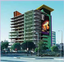
Multi-use, multi-story structures will increase West Auburn Boulevard’s visibility from the Capital City Freeway
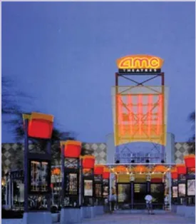
High visibility signage attracts potential customers from the freeway
A. Vision
Section titled “A. Vision”Given its proximity to downtown Sacramento, the success of recent redevelopment initiatives, and the constrained availability of affordable sites for commercial development adjacent to a major freeway, West Auburn Boulevard is poised to become a signature business address and vital commercial destination within the region. Building on the intent of the Auburn Boulevard Community Redevelopment Area Implementation Plan, the West Auburn Boulevard Streetscape Master Plan and Special Planning Area Ordinance create a framework for redevelopment by identifying potential improvements that will attract business investment to the Plan area.
Key to the success of the Plan is the treatment of intersecting corners. The ‘crown jewel’ of the Boulevard is the intersection of Auburn Boulevard and Fulton Avenue as this is the only location that allows full access from the freeway and into the geographical center of the Plan area. The redevelopment of the parcels on both sides of this intersection is vital to the success of this project and should be scrutinized accordingly to ensure that the vision and goals of this project are recognized through site design. The remaining intersections also play a vital role in the economic vitality of the Boulevard. These intersections are envisioned as mixed use opportunities, where housing or office space is situated immediately above retail or service uses. These corners should be treated with significant site design care by creating buildings closer to the street and pedestrian spaces and placing parking behind the buildings.
In addition, the following vision statements apply to the Plan area:
- New buildings and streetscapes including trees, common signage, lighting and landscaping will enhance the overall image of the Boulevard and create an attractive portal to the Arden-Arcade community.
- The West Auburn Boulevard Plan area will develop into a center for auto sales and services, home and garden design, retail, commercial, recreation, leisure activities, and attractive housing opportunities.
- Restaurants, entertainment and recreation centers will serve the existing community residents and new residents along the Boulevard and will attract patrons from throughout the region.
- The Boulevard will expand and grow to become an economic engine for public services and continued economic growth that will extend to the surrounding neighborhoods.
- The Boulevard will provide commercial services and retail that are lacking in the adjacent community.
- The Boulevard will become linked with public amenities such as the Haggin Oaks Golf Course.
- The Boulevard will become a notable landmark area known throughout the region for the high quality streetscape and building architecture. The design quality will be reflected in the Boulevard through:
- Architecture
- Signage
- Streetscape
- Lighting
- The landscaping, signage and signature elements located along the public streets and the architecture of individual buildings will provide a form of public art.
- Commercial uses will not be oriented only to street fronts. Retail and leisure recreation uses (i.e. restaurants) penetrate to the rear of individual parcels and ‘open up the block.’
- The combination of attractive views toward the golf course, proximity to downtown jobs and new neighborhood services will create opportunities for high density housing.
- Creation of more intensive land use, new public services, new shopping destinations and new higher density housing will increase use of public transit.
- The history of the Arden-Arcade Community and surrounding area will be celebrated in the signage and streetscape themes.
B. Goals
Section titled “B. Goals”The redevelopment strategy for West Auburn Boulevard focuses on leveraging the key attributes of the Plan area-location, convenience, and visibility-to provide an attractive framework for future growth. To achieve the goals inherent in the vision for West Auburn Boulevard, this Master Plan, recommends achievable ways to
- Develop a Land Use Plan and Special Planning Area Ordinance that address, encourage and support quality infill commercial development along the corridor;
- Create a strong, positive community identity through the use of high quality signage, enhanced landscaping, common interest marketing, and media awareness of West Auburn Boulevard’s heritage and environment;
- Improve public rights-of-way to enhance the aesthetic appeal of West Auburn Boulevard to businesses and shoppers;
- Make full use of the existing public investment in infrastructure including public transit;
- Eliminate infrastructure deficiencies along with completing the streetscape improvements, to further strengthen the long-term competitiveness of the Plan area;
- Create a dynamic business environment that attracts new investment and helps to realize West Auburn Boulevard’s potential as a commercial destination within the region;
- Maximize new development opportunities, but minimize new demands on natural resources, notably clean air, clean water and energy;
- Develop improved freeway access, and heighten visibility of the Boulevard for people traveling on the freeway;
- Promote quality design through improvement projects that serve as catalysts for attracting additional investment;
- Fulfill the unique retail and marketing opportunities afforded by the traffic and regional location;
- Enhance the adjacent neighborhood and Arden/Arcade community;
- Encourage new auto sales within appropriately sized parcels centered on Fulton Avenue;
- Establish a landmark identity and style to create a district recognized throughout the region;
- Promote infill and commercial development; and
- Support established businesses and provide an employment base for the community.
C. Objectives
Section titled “C. Objectives”The core objectives relate to providing physical improvements and establishing a policy framework and standards for implementing the economic development goals of the Plan. It is inherent in the relationship of economic development and physical improvements that they are mutually beneficial. Economic development provides the funding resources to create additional attractive site improvements and buildings. In turn, these improvements attract additional investments.
- Analyze proposed land uses for West Auburn Boulevard’s commercial corridor;
- Integrate input received at project management team meetings, stakeholder workshops and public charettes;
- Utilize vacant land to promote appropriate infill commercial development that supports well-established businesses and provides an employment base for the community;
- Create a strong identity and develop a vibrant, contemporary commercial corridor that includes:
- Themes to enhance identity;
- Landscaped medians and colored pavers;
- Improved streets, sidewalks, curbs and gutters for better vehicle, pedestrian and bicycle traffic;
- Lighting, including decorative lighting and traffic signals;
- ADA compliance;
- Enhanced freeway frontage, visibility and aesthetic enhancements;
- Intersection and off-ramp enhancements;
- Parking and reciprocal access opportunities and improvements;
- Gateway signage and other identifying enhancements and themes for the commercial corridor;
- Specialty treatments at bus stops, walkways to businesses, driveways, and other points of interest;
- Frontage trees, landscape and hardscape improvements;
- Future traffic congestion issues;
- Establish Design Guidelines that address architecture, landscape, lighting, set-backs, signage and other property amenities and standards;
- Identify non-conforming uses to be phased out and/or prevented as future uses that negatively affect commercial viability;
- Identify current policies (including setback requirements, land uses, etc.) to be re-evaluated and possibly altered;
- Establish distinctive gateways to the Arden-Arcade community;
- Establish a strong and attractive sense of place and identity for the Boulevard;
- Enhance traffic safety along the Boulevard and the adjacent streets.
SECTION THREE: Special Planning Area Ordinance
Section titled “SECTION THREE: Special Planning Area Ordinance”Form-based regulations are prescriptive. That is, they guide development to desired outcomes by example rather than by precluding or prohibiting certain development characteristics.
Section Three details how the Special Planning Area Ordinance creates a single new land use zone classification cation that accommodates all land uses envisioned in this Plan area.
The West Auburn Boulevard Special Planning Area Ordinance (SPAO) will include land uses that are not typically combined in conventional land use zones. The mix of land uses will be regulated with ‘form-based’ zoning that allows different but appropriate land uses based on the site conditions and the relationships between land uses rather than rigid land use categories.
A. The Special Planning Area Zone Ordinance
Section titled “A. The Special Planning Area Zone Ordinance”The authority for Special Planning Areas (SPAs) is established in the Sacramento County Zoning Ordinance. The purpose of the SPA is to regulate properties that have unique environmental, historic, architectural, or other features which require special conditions not provided through the application of standard zone regulations.
As established in the Zoning Ordinance, the Special Planning Area Ordinance shall provide for the following matters:
- A list of permitted uses;
- Performance and development requirements relating to lot area, intensity of development on each lot, parking, landscaping and signs;
- Other design standards appropriate for the specific site and development; and
- Reasons for establishment of an SPAO Land Use Zone on the particular property.
Relationship to the County Zoning Ordinance
Section titled “Relationship to the County Zoning Ordinance”The SPAO is intended to be comprehensive and to replace the current zoning and land use regulations within this Plan area. However, the SPAO does not address certain detailed standards that are best addressed on a County-wide basis, for example, parking requirements. Where the SPAO is silent, the Sacramento County Zoning Ordinance shall apply.
Form-Based Regulations
Section titled “Form-Based Regulations”Form-based codes differ from conventional codes in terms of the substance of the standards they contain, the mechanisms by which they are implemented, and the built form they produce. The land use and design regulations are derived from the urban form rather than simple categorization of the land uses according to the similarity of use. The regulations are affected by such factors as the location on the street, the relation to adjacent land uses, the scale of the buildings, and the type of uses. Although there is only a single zoning standard for the entire
Form-based codes are typically more prescriptive than conventional codes in establishing design requirements for development. That is, they provide more detailed regulations based on a specific vision of the intended built result, and regulate certain features of development beyond those covered by conventional codes.
Plan area, the development regulations define differences from location to location depending on use and other factors that guide land use.
Form-based codes are typically more prescriptive than conventional codes in establishing design requirements for development. That is, they provide more detailed regulations based on a specific vision of the intended built result, and regulate certain features of development beyond those covered by conventional codes. (Adapted from ’Removing Obstacles to Blueprint Implementation: Scoping Services for Model Form-Based Code or Alternative Strategy, ’Sacramento Area Council of Governments, Administrative Draft Report, 5 April 2006).
The purpose of form-based regulations (also referred to as ‘form-based code’) is to allow design creativity within a flexible context and encourage maximum use of the development area. However, the purpose of this SPAO is also to provide certainty and timeliness in the process for review and approval of development applications. Therein lies a challenge for the form based regulation: to provide design flexibility and a certain amount of creativity in the planning process, yet to also limit the discretionary actions to a level that can be addressed in an administrative process.
The approach taken in this SPAO is to first define the objective of the standards and then to define standards that require a level of performance or a condition that can be readily determined at an administrative level. It is expected that there will be many ways to achieve some standards (such as parking area shading requirements) and thereby allow considerable design flexibility. Other standards are inherently more specific (such as side Yard setbacks) that are absolute minimum requirements.
Application Form and Process
Section titled “Application Form and Process”New development and remodels of existing structures that exceed 10,000 square feet in floor area shall make an application for Design Review pursuant to the standards and guidelines set forth in this Plan. The form of application shall be as determined by the County Planning Director and shall include information requirements consistent with the submittal requirements established in the Community Design Guidelines: Commercial and Mixed-Use Development. (See Sacramento County web site for Development Application Forms.)
The non-discretionary development applications that comply with the standards established in this SPAO shall be approved in an administrative review process as outlined in the Appendix of this Plan.
A development application that deviates from this SPAO such that it must be referred to the Arden-Arcade Community Planning Council and/or Board of Supervisors may require only a Mitigated Negative Declaration or supplemental environmental documentation to comply with the California Environmental Quality Act (CEQA).
Organization of the Special Planning Area Ordinance
Section titled “Organization of the Special Planning Area Ordinance”The SPAO describes the existing planning context including opportunities and constraints that suggest the vision for future development. The Plan defines a concept of the economic development opportunities in the Plan area in terms of an appropriate mix of land uses and design principles and strategies. This concept defines a list of appropriate land uses that will be permitted. This SPAO provides operational characteristics regulations to allow certain permitted uses that would otherwise require a conditional use permit.
In addition to the list of permitted uses and the development standards found in a conventional zoning ordinance this SPAO also defines urban form zones and building types. The development standards are tailored to the specific conditions within and vision for this Plan Area. All land uses are permitted at any location within the Plan Area, however, compliance with the form based zones will direct certain uses and building types toward more appropriate locations and away from less appropriate locations.
The building type descriptions and the urban form zones defined in the following sections provide a guide to the intended uses and development patterns. This approach will avoid incompatible uses but allows for creative design solutions that may allow a use or combination of uses to be located where it would otherwise be considered inappropriate.
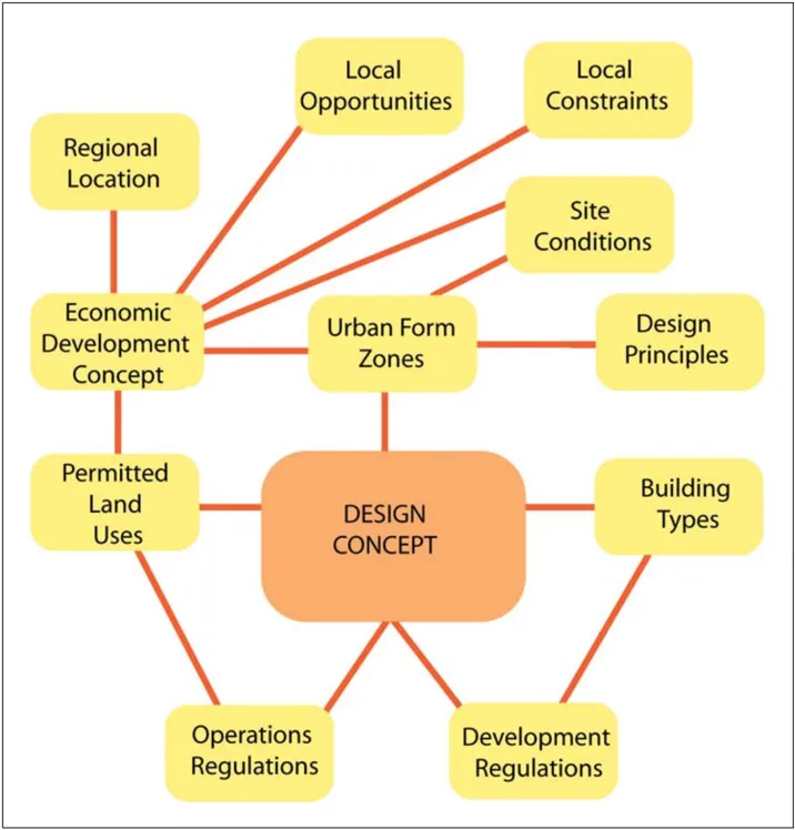
Schematic of the Special Planning Area Ordinance Organization
Within this radius is an established population of more than 400,000.
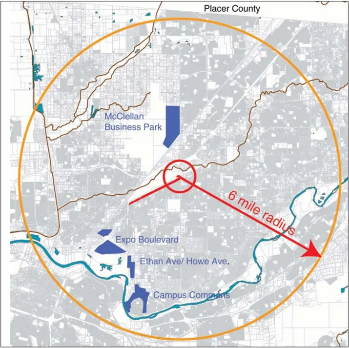
Local Context Map
B. Community Planning Context
Section titled “B. Community Planning Context”The opportunities for new economic growth and development on West Auburn Boulevard reflect the character of the regional market area and the specific character, history and land uses of the surrounding community.
Location in the Region
Section titled “Location in the Region”West Auburn Boulevard is situated near the geographical center of the established population in the northeast quadrant of Sacramento County. Businesses can attract patrons from the immediate neighborhood to the south along major road connections that extend south into the ArdenArcade Community (Howe Avenue, Fulton Avenue and Watt Avenue). The Plan area is also easily accessible from neighborhoods farther to the east along Auburn Boulevard.
The Plan area is within one mile of the Capital City Freeway and the I-80 interchange known as the ‘Madison Split.’ The entire northeast Sacramento region is within a reasonable driving distance of the Plan area. A six mile radius centered on the east end of the Plan area at Watt Avenue would extend from Roseville on the north to Folsom Boulevard on the south, and from Sunrise Boulevard on the east to downtown Sacramento and the South Natomas area on the west. Within this radius is an established population of more than 400,000.
Proximity to Employment Centers
Section titled “Proximity to Employment Centers”Nearby employment can provide significant business support for several of the business activity types envisioned for the Plan area. Employees would patronize restaurants, entertainment, leisure activities, specialty retail shops and personal services during their day and after work.
Currently, the primary employment areas are in the southwest quadrant of the community near Ethan Way and Howe Avenue. Although Watt Avenue to the north of the Capital City Freeway provides commercial land use, there are currently few food services. McClellan Business Park, located approximately two miles north on Watt Avenue, has the potential to provide a patronage base as employment at the business park grows.
Increased employment along the Boulevard and within a reasonable drive time, and expanded restaurant service, could make the Boulevard a more attractive daytime destination.
Arden-Arcade Community
Section titled “Arden-Arcade Community”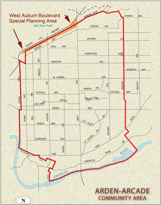
Arden-Arcade Community Area
Today, Arden-Arcade is one of the most heavily developed areas of urban Sacramento.
Existing Parcels
The shape of the parcels is important because it determines to a significant degree the types of businesses that will be viable along the Boulevard as it becomes more developed and land values rise.
The West Auburn Boulevard SPAO is the north edge of the Arden-Arcade community. The community encompasses about 21-square miles and extends south to the American River. The Arden-Arcade community provides a rich history commencing with the early settlement of the Sacramento region.
The community is part of the Del Paso Ranch, nationally renowned as a significant center of racehorse breeding in the late 19th century. The naturally appealing setting of the community along the south side of Arcade Creek lead to early development as a ranching area.
Much of Arden-Arcade began to develop in the 1940’s with the Town and Country Village shopping center (the first suburban shopping center in Northern California). Most of the population growth in Arden-Arcade occurred up through the 1960’s and 1970’s. An estimated 75 percent to 80 percent of the community was developed with urban uses.
Today, Arden-Arcade is one of the most heavily developed areas of urban Sacramento. Despite the intensity of uses, a combination of contemporary neighborhoods, graceful older residential areas, substantial frontage along the American River Parkway, and unique shopping areas have created a distinctive charming character for Arden-Arcade.
C. Planning Design Context
Section titled “C. Planning Design Context”Opportunities for development are strongly influenced by the physical conditions along and around the Boulevard. The following describes the key features of the Plan area that affect future development.
Available Land Area
Section titled “Available Land Area”The Plan area encompasses 71 individual parcels totaling 123.3 net usable acres. Approximately 45 percent of the net usable area, or 55 acres, is currently vacant or under-utilized (refer to the discussion regarding ‘transitional’ land uses).
Shape and Size of Individual Parcels
Section titled “Shape and Size of Individual Parcels”Properties fronting the Boulevard are typically of uniform depth of 450’ from the edge of the right-of-way. The parcel depth is comparable to the length of a single city block in downtown Sacramento. This lot depth (front sidewalk to rear lot line) is too shallow for many contemporary commercial uses, such as conventional supermarket-based centers and ‘big box’ retail stores (such as Home Depot or Wal-Mart), but is appropriate for furniture stores and other uses of similar size envisioned in this SPAO. The Deseret Industries store and complex are examples of larger retail stores.
Conversely, the lot depth is too great for many narrow parcels with building uses that rely on Boulevard frontage. Smaller uses do not need the entire site. Consequently, the rear portions of parcels are currently under-utilized in some instances.
The lot width varies from approximately 50’ to 485’. There is no standard lot width; however, lot widths of approximately 110’ occur more frequently than any other. A lot that is 110’ by 450’ has a depth-to-width ratio of more than 4:1.
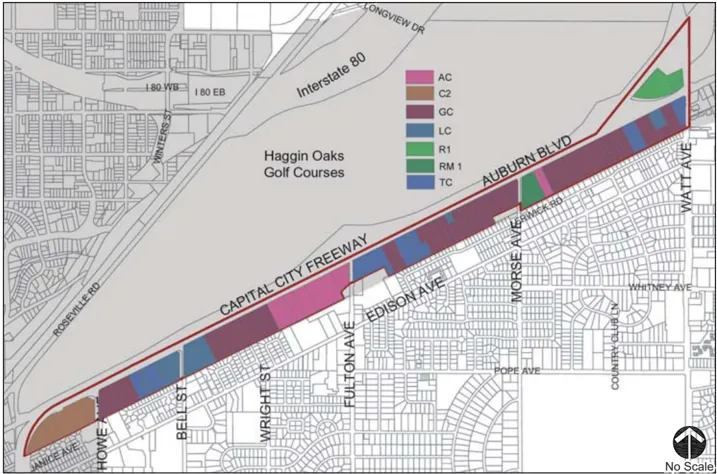
| Existing Zone Classification | Land Use | Parcels | Acres |
|---|---|---|---|
| (AC) | Auto Commercial | 10 | 15.2 |
| (C2) | Commercial (City of Sacramento) | 4 | 9.6 |
| (GC) | General Commercial | 32 | 56.3 |
| (LC) | Limited Commercial | 6 | 10.4 |
| (R1) | Single Family Residential | 2 | 5.3 |
| (RM-1) | Mobile Home Subdivision | 4 | 10.0 |
| (TC) | Highway Travel Commercial | 13 | 16.5 |
| Total | 71 | 123.3 |
Existing Land Uses
Existing Land Use
Section titled “Existing Land Use”Many existing commercial uses reflect the historic role of the Boulevard as a major highway. The area consists of an eclectic mix of hotels, auto dealerships, home retail stores (i.e. furniture, lighting, and imports), a variety of other destination commercial retail, music and dance destinations, small restaurants, residential uses (i.e. senior and mobile home parks), and a substantial number of vacant parcels.
New auto dealerships are an active category of new business development and suggest the continued expansion of these businesses as a significant use.
Small pockets of residential uses are found in older mobile home parks that front onto the Boulevard.
Existing Zoning Classifications
Section titled “Existing Zoning Classifications”Existing zoning in the Plan area includes seven distinct zone districts, including zone (C2) in the City of Sacramento. The zone districts are primarily commercial classifications, but also include two residential zone classifications. The existing zones and the acres allocated to each are summarized in the Existing Zone Classification Table on page 3.5.
The adoption of the West Auburn Special Planning Ordinance would rezone all existing County zone classifications into a single form-based land use zone as described in this SPAO.
Adjacent Land Use
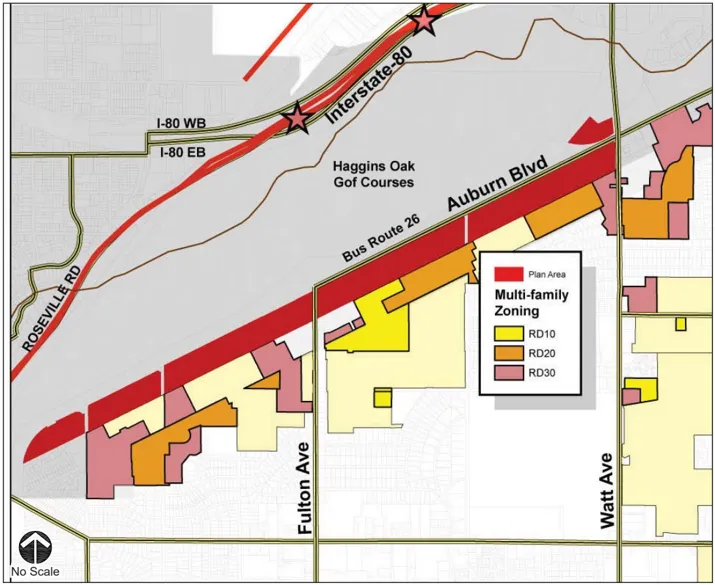
Section titled “Adjacent Land Use”Existing zoning and land use adjacent to the Plan Area includes a high percentage of multi-family residences.
To the south of the Boulevard, commercial uses abut older residential neighborhoods that include suburban style single-family homes and apartments.
Approximately 187 acres adjacent to the Plan area is designated and developed as multi-family residential uses (R10, R20 and R30). If built at the maximum density allowed under the current zoning, this would yield approximately 4,255 dwelling units. The existing apartments appear to be developed at more modest densities of approximately 15 to 20 dwelling units per acre. Nonetheless, this area is substantially more dense than most suburban communities in Sacramento County.
This is an unusual opportunity to supplement the existing residential core with additional residential uses along the Boulevard. The high density residential use and supporting commercial uses along an existing transit corridor would be the foundation for a significant transit-oriented development core.
Adjacent Land Use
Access to Public Transit
Section titled “Access to Public Transit”Regional Transit Bus Route 26 runs through the Plan area from Watt Avenue to Fulton Avenue. The route connects to the Watt Avenue Light Rail Station and south along Fulton Avenue to connect to the University/65th Street Light Rail Station. Bus stops are located along the south side of the Boulevard at a number of locations, but west bound buses stop on the north side of the Boulevard at only one location, opposite the Deseret Industries Thrift Store.
The Watt Avenue Light Rail Station is located approximately one-half mile north of the Boulevard.
Local Street Connectivity to the Adjacent Residential Area
Section titled “Local Street Connectivity to the Adjacent Residential Area”Unlike many other urban and suburban boulevards, Auburn Boulevard has relatively few intersections with local streets that extend into the adjacent neighborhood.
Intersections are limited to the major north-south oriented streets that are spaced at approximately one-half mile intervals. Watt Avenue and Fulton Avenue are major commercial streets with little or no residential uses near the Boulevard. Howe Avenue, Morse Avenue and Bell Street have residential neighborhoods adjacent to the commercial uses, but these neighborhoods have a very weak relationship to the Boulevard due to the lack of neighborhood-serving businesses.
The adjacent neighborhoods appear to have only a limited relationship to the Boulevard in terms of pedestrian activity. This results from the lack of street connectivity, relatively long block length between major streets and the lack of local services on the Boulevard.
Connectivity
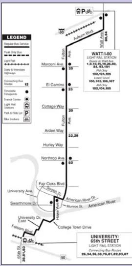
Bus Route #26
Freeway Access
Section titled “Freeway Access”Access from the Capital City Freeway to the Boulevard occurs at Howe Avenue, Bell Street, Fulton Avenue and Watt Avenue. Watt Avenue and Fulton Avenue are full interchanges that offer access and egress in all four directions. However, these are older facilities that are constrained by existing development.
Bell Street and Howe Avenue are short ‘hook’ ramp interchanges that allow only eastbound egress and ingress to the freeway. The hook ramps allow traffic exiting the freeway to cross the path of traffic accelerating onto the freeway.
Adjacent Amenities (Haggin Oaks Golf Courses)
Section titled “Adjacent Amenities (Haggin Oaks Golf Courses)”The Haggin Oaks golf courses to the north of the freeway provide a visual amenity for the Plan area. The courses and ancillary facilities are an attractive green space that contrasts with the urban intensity of the freeway and Boulevard. Although separated from the Boulevard by the freeway and often obscured from view at ground level, the golf courses can be a significant visual asset when viewed from the second or higher floor of buildings on the Boulevard.
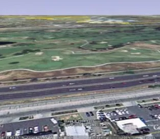
Haggin Oaks Golf Courses
View from the Freeway
Section titled “View from the Freeway”Although adjacent to a major freeway, not all properties fronting on Auburn Boulevard have high visibility. For motorists in the west-bound lanes of the freeway, the center median barrier effectively blocks the view of the first level of all buildings. Only the second floors of buildings, a few communications towers and scattered tree tops, most notably clusters of tall palm trees, are visible from the west-bound lanes. In addition, much of the view is obscured by a high-tension power line on metal poles located along the freeway edge.
The motorist’s view from the east-bound lanes, in some cases, is directly to the building fronts on the Boulevard. However, the east-bound view is also obscured at locations by grade differences (notably near Fulton Avenue), vegetation and the fence located along the edge of the right-of-way.
The freeway sweeps away to the north as it approaches Watt Avenue from the west and the Boulevard frontage is not visible from the freeway. The view at this location is a rental storage facility located between the freeway and the Boulevard.
A direct view of the ground level of buildings occurs at approximately 50 percent of the Boulevard frontage through the Plan area.
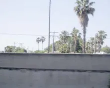
Freeway Views
Freeway noise will be a factor in considering residential development fronting on the Boulevard. Typical sound walls along the freeway will not be practical where it is important to maintain a view toward Boulevard businesses. Buildings that house noise-sensitive uses will need to incorporate internal noise mitigation measures or be located near the Fulton Avenue bridge where the freeway is depressed below grade.
Air Quality
Section titled “Air Quality”Traffic generated air pollution will also be a factor in considering residential development, some employment intensive uses and other sensitive uses along the freeway.
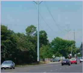
High Tension Power Lines
Section titled “High Tension Power Lines”The view along the Boulevard and the view from any future buildings to the golf courses will be affected by power lines along the sides of the Boulevard. On the south side, 12 kv electric power lines as well as telephone lines can be placed underground in the future streetscape improvements.
The larger high-tension electric lines on steel poles located on the north side of the street cannot be located underground and will remain as a major visual blight. Trees cannot be placed under these power lines.
D. Plan Area Vision: Land Uses and Building Activity Types
Section titled “D. Plan Area Vision: Land Uses and Building Activity Types”The vision for the Plan Area includes two distinct components: retail sales and specialty services, leisure and recreation services that have a regional draw; and retail and businesses that serve the residents and employees in the local market area. Residential uses will be mixed in with other uses or will be stand alone uses. The uses envisioned in the Plan Area are listed in the permitted uses table and are summarized in the following description of different building types.
A variety of land uses can occur at any location on the Boulevard in a variety of building types. The development regulations described in Section Four are intended to accommodate the following building types:
- Office
- Auto Sales and Related Uses
- Specialty Retail
- Furniture and Home Improvement Retail
- Leisure, Entertainment and Recreation Uses
- Neighborhood Retail and Services
- Cluster Development
- Small Front Retail
- Multi-Family and Residential/Mixed Use
The following sections describe the design intent and the appropriate land uses for each building type.
Office
Section titled “Office”The West Auburn Boulevard corridor has yet to establish a presence in the regional office market. Existing office uses include only the medical office at Bell Street and a scattering of older single story buildings. However, a number of factors suggest that the Boulevard can develop a secondary office market. Among these are the proximity to downtown; the proximity to Cal Expo and the lodging facilities and secondary office market in the Arden Way area; the golf courses adjacent to the Plan area; freeway access; and high visibility from the freeway.
The shape and size of the larger parcels could accommodate multistory office buildings in an attractive landscaped setting with surface and/or structured parking.
Office uses would occur in either stand alone buildings or mixed with high density residential, restaurants, other services and incidental retail uses. The Boulevard provides an opportunity for tall buildings to offer attractive views to the golf courses and Arcade Creek to the north.
Lodging
Section titled “Lodging”Lodging will continue to be a viable commercial activity along the Boulevard. New lodging facilities along the Boulevard are modern versions of the traveler and business motels that have been a mainstay of the old Boulevard. The Capital City Freeway is not the primary travel route for long distance travelers, but the location continues to be convenient for travelers and business people in the northeast quadrant of the region.
Auto Sales and Related Uses
Section titled “Auto Sales and Related Uses”On-going investments in new auto sales facilities suggest that auto sales, service, and related businesses could be a key component of the Boulevard’s economic development. The properties provide high visibility along the freeway, and the width and depth of many parcels are well suited to auto sales operations. The SPAO envisions the Boulevard continuing to grow as a regional auto sales center.
Auto-related businesses would include new auto sales, auto parts sales, auto repair services and auto rental services.
In addition, the auto sales and service businesses would create a need for customer service and convenience businesses. Examples include: a hair salon or barber and a coffee shop/cafe where customers could enjoy a meal or a cup of coffee while waiting for service on their vehicle. These businesses would also serve the local community and freeway travelers.
New auto retail is a specialized activity that requires a specialized building type. Unlike most large retail uses, the interior sales floor is an extension of the exterior sales area (the parking lot). The exterior parking is substantially greater in proportion to the interior sales area and thus the building covers a relatively small portion of the site compared to other retail buildings. The auto sales building type also differs in that it often includes ancillary service and sales activities that may be located within the primary building or in separate buildings on the property. Street exposure is a dominant concern for auto sales.
Extraordinary signage, lighting, flags, banners and similar devices to attract attention to the sales area are typical. Building design is likewise used as a means to attract attention and to serve as a signature for the particular brand.
The challenge is to provide a highly visible sales area while maintaining a sense of quality and compatibility with the overall Boulevard design.
Large Box Retail
Section titled “Large Box Retail”The Large Box building type includes any building with a cumulative facade of 150’ or greater oriented to the street. These buildings may include a single large use or have multi-tenants.
Furniture and Home Improvement Retail Activity
Section titled “Furniture and Home Improvement Retail Activity”Furniture and home improvement retail stores are a typical form of large box buildings, but also occur in smaller buildings along the Boulevard.
West Auburn Boulevard has long been the location of several furniture and home decorating businesses that benefit from the freeway visibility and convenient location. The parcels are well suited to accommodate a retail store area and the parking, storage warehouses, truck loading and service areas these businesses require.
With the planned improvements to the Boulevard (i.e. streetscape landscaping, signage, and lighting) there is an opportunity for expansion of home improvement related businesses.
The design standards for the SPAO will support unique building designs that contribute to the desired destination character and landmark stature of the Boulevard.
Leisure, Entertainment and Recreation Uses
Section titled “Leisure, Entertainment and Recreation Uses”West Auburn Boulevard is well located to provide a broad range of leisure and recreation oriented businesses. Examples include: restaurants and meeting facilities, entertainment centers, fitness centers, sporting goods sales and service.
The high traffic volumes along the freeway, the ready access from a large market population within six miles, and proximity to well-established neighborhoods indicate a potential for businesses with a regional draw.
The nearby Haggin Oaks Golf Courses, Del Paso Park and the regional softball complex, and Cal Expo suggest that the Boulevard could accommodate recreation themed businesses, restaurants and meeting facilities that would complement the events and activities at these nearby facilities.
The freeway location makes the Boulevard a convenient place to stop on the way to and from work, perhaps to visit a gymnasium or sports facility.
A few notable entertainment, music, dance, and leisure-oriented shops and services already occupy the Boulevard. The addition of new entertainment facilities, such as restaurants, dinner clubs and comedy clubs could establish the Boulevard as a regional entertainment district.
These land uses could also host special events such as dances, music festivals, art and craft festivals, and other similar gatherings.
Neighborhood Retail and Services
Section titled “Neighborhood Retail and Services”The Arden-Arcade community includes a number of commercial-core areas that serve residents. The West Auburn Boulevard corridor is located at the very north edge of the community and therefore is not central to most of the residents. However, the residential areas immediately to the south of the Plan area are not well served by neighborhood retail and services. Moreover, there are few locations within or near these neighborhoods that can provide space for such services or retail without displacing an existing business.
Appropriate businesses would include: restaurants, small retail stores, and a variety of personal and professional services.
Cluster Development
Section titled “Cluster Development”The Cluster use type can include taller buildings in groups that define common open space, such as plazas.
The SPAO encourages the design of mixed-use blocks in which smaller shops and offices are clustered in the center and toward the front of the parcels.
The properties along the Boulevard are generally not suited to small businesses because the properties are too deep to be fully utilized by small businesses.
Efficient development of these deep and narrow lots requires a strategy to allow for more width in the core of the parcel. Commercial uses naturally tend to maximize their frontage exposure to passing traffic, but many of the parcels are relatively narrow and the full depth of the parcel is not efficiently utilized.
One strategy is to aggregate them into configurations that approximate at least a 2:1 depth to width ratio and preferably closer to a 1:1 ratio. Once aggregated, the lots can be developed in a single large use oriented to the street or may be developed in multiple uses that penetrate the rear of the lot as well as provide street front orientation.
Another strategy is to allow shared parking and shared driveways that cross from one parcel to another near the middle or rear of the parcels.
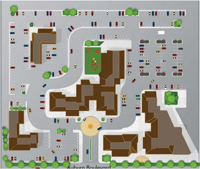
Example of Cluster Development
Building facades along the Boulevard may be opened to provide access to uses in the interior of a parcel. Smaller, pedestrian-scale buildings would be located in the center and rear of the parcel to fully utilize the site and extend to the street to provide a visual and pedestrian connection from the sidewalk along the Boulevard. The cluster building activity type is intended to connect to similar parcels to either side and thereby effectively increase the interior width of the narrow parcels. Interconnecting driveways between parking areas, joint parking areas, and interconnecting pedestrian paths are strongly encouraged.
These ‘pedestrian enclaves’ would provide the smaller scale uses, such as, restaurants, smaller retail stores, services and offices. These could include uses that have a community-wide draw, but are particularly suited to uses that serve the local neighborhood.
Small Front Retail
Section titled “Small Front Retail”The small front building type includes those with less than 150’ of frontage oriented to the street. Small front retail is the most common single-use building type currently located on the Boulevard. Many existing parcels have a street frontage of 110’ or less. Aggregation of these narrower parcels will be dif fi cult due to recent development adjacent to them. The challenge with these buildings is to make the most use of a deep lot that may have more land than is needed.
Where the cluster building type is not practical, the site can be developed as a small front building. In these cases the building would present a conventional frontage to the Boulevard, but would include parking areas and building fronts oriented to the side or rear property boundary.
Example of Small Front Retail
Multi-Family and Mixed-Use Residential
Section titled “Multi-Family and Mixed-Use Residential”Multi-family housing in this Plan area would be attractive to seniors and young professionals who appreciate the proximity to downtown jobs, the urban lifestyle, the access to public transit (including light rail), the view across the freeway to the Haggin Oaks Golf Courses, and the proximity to recreation opportunities. Ultimately, the Boulevard will become known as a lively place to live if the following objectives are fulfilled; high design standards, a mix of entertainment, recreation and leisure activities.
The multi-family residential type would be stand alone apartment buildings or integrated in a mixed use building with office and/or commercial uses. In most cases it is likely that multi-family residential uses would be located adjacent to non-residential uses. Providing private space for recreation and leisure within the building type must be a major design consideration.
The integration of multi-family residential use will require careful design to ensure the peace and privacy of the occupants and for the existing residents to the south. Design of residential uses will require mitigation of freeway noise and screening of views into the adjacent residential areas.
E. Permitted Land Uses
Section titled “E. Permitted Land Uses”The West Auburn Boulevard SPAO shall apply to all land uses envisioned in this Plan.
The table of Permitted Land Uses summarizes the permitted (P) and conditionally permitted (CUP) uses in the SPAO. Uses not included in the table of Permitted Land Uses shall be considered to be prohibited in the Plan area. The Planning Director has discretion as to application of the guidelines relative to allowed versus non-allowed uses.
Specific standards that regulate hours of operations, noise, and light and truck traffic are assigned to certain land uses. Notations in table of Permitted Land Uses indicate the specific considerations or conditions that may apply to certain uses. These are described in footnotes following the table of Permitted Land Uses.
Note: If there is a use in the table that is missing, refer to Section 225-11 in the Sacramento County Zoning Code and refer to the uses that are allowed in the Limited Commercial (LC) Zone for all of the properties within this SPA.
Permitted Land Uses Table
Section titled “Permitted Land Uses Table”This table has been split into multiple tables to comply with accessibility requirements. The following twenty tables shall all be referred to as a part of Permitted Land Uses Table
A. AUTOMOTIVE SALES, SERVICE, REPAIR
Section titled “A. AUTOMOTIVE SALES, SERVICE, REPAIR”| Permitted Land Uses | Footnotes |
|---|---|
| 1. Auto Sales, Auto Broker, New/Used | 1, 2, 3, 4, 5, 6,12 |
| 2. Auto Rental or Lease Agency, Including Limousine Service | N/A |
| 3. Auto, Service - Repair - Replacement (Not a part of Auto Sales, New) | N/A |
| 4. Auto Service Station, Primary | CUP |
| 5. Auto Parts and Accessory Store | N/A |
| 6. Auto Wash, Self-Service or Automatic | 7 |
| 7. Camper Shell - Sales, Repair, Rent | N/A |
| 8. Motorcycle, Sports Cycles, Trail Bikes, Jet Skis, Snowmobile, Ultra-Light, Moped - Sales, Rent, Service, Repair | 8 |
| 9. Gasoline Sales and Service Station | CUP |
B. BUSINESS SERVICES
Section titled “B. BUSINESS SERVICES”| Permitted Land Uses | Footnotes |
|---|---|
| 1. Advertising Business | N/A |
| 2. Blueprinting-Photostatting Service | N/A |
| 3. Computer Programming/Software and System Design | N/A |
| 4. Computer Sales, Rental and Lease | N/A |
| 5. Computer Service and Training | N/A |
| 6. Data Processing Service | N/A |
| 7. Delivery Service | 9 |
| 8. Drafting Service | N/A |
| 9. Furniture Rental Agency | N/A |
| 10. Janitorial Service | 9 |
| 11. Locksmith - Safe Repair Shop | N/A |
| 12. Messenger Service | N/A |
| 13. Office Machines and Equipment Sales and Minor Repair | N/A |
| 14. Photocopy Service | N/A |
| 15. Print Shop | N/A |
| 16. Remote Teller, Freestanding for Pedestrian Use | N/A |
| 17. Stenographic Service | N/A |
| 18. Studio - Radio, Television, Recording | N/A |
| 19. Ticket Agency | N/A |
C. HEALTH SERVICES
Section titled “C. HEALTH SERVICES”| Permitted Land Uses | Footnotes |
|---|---|
| 1. Clinic, Child Family Guidance | N/A |
| 2. Clinic, Counseling | N/A |
| 3. Clinic, Diet Counseling with Incidental Sales of Diet Products | N/A |
| 4. Clinic; Kidney Dialysis | N/A |
| 5. Clinic, Physical Therapy | N/A |
| 6. Eyeglasses, Frames, Contact Lens - Sales and Service | N/A |
| 7. Hearing Aids - Sales and Service | N/A |
| 8. Laboratory - Medical, Dental or Optical | N/A |
| 9. Medical or Dental Office | N/A |
| 10. Orthopedic Appliances Sales/Service | N/A |
D. PERSONAL SERVICES
Section titled “D. PERSONAL SERVICES”| Permitted Land Uses | Footnotes |
|---|---|
| 1. Barber Shop | N/A |
| 2. Beauty Shop and Wig Sales | N/A |
| 3. Child Care Center | N/A |
| 4. Dressmaker / Tailor | N/A |
| 5. Reducing-Body Building/Aerobics Studio | 7 |
| 6. Shoe Shine Parlor | N/A |
| 7. Studio - Dance, Voice, Music, Gymnastics | 7, 10 |
| 8. Social Center | 10 |
E. MISCELLANEOUS SERVICES
Section titled “E. MISCELLANEOUS SERVICES”| Permitted Land Uses | Footnotes |
|---|---|
| 1. Laundromat, Self-Service | 10 |
| 2. Laundry or Cleaning Agency, Retail (On-Site Cleaning Permitted)’ | N/A |
| 3. Parking Lot or Garage as Primary Use | N/A |
| 4. Photography Studio, Including Incidental Processing | N/A |
| 5. Picture Framing Shop | N/A |
| 6. Travel Agency | N/A |
F. REPAIR SERVICES (SEE SECTION A FOR AUTO REPAIR)
Section titled “F. REPAIR SERVICES (SEE SECTION A FOR AUTO REPAIR)”| Permitted Land Uses | Footnotes |
|---|---|
| 1. Appliance Repair Shop | N/A |
| 2. Electronic Equipment Repair | N/A |
| 3. Shoe Repair Shop | N/A |
G. EATING/DRINKING/LODGING
Section titled “G. EATING/DRINKING/LODGING”| Permitted Land Uses | Footnotes |
|---|---|
| 1. Soda Fountain-Ice Cream Parlor | N/A |
| 2. Restaurant-Coffee Shop-Cafeteria | N/A |
| 3. Bakery, Pastry Shop | N/A |
| 4. Bar-Tavern | 10, 11 |
| 5. Brew Pub (No Wholesale or Off-Site Sale of Beer, Wine, or Alcohol) | 10, 11 |
| 6. Catering Service | N/A |
| 7. Delicatessen | N/A |
| 8. Hotel | CUP |
| 9. Motel | CUP |
H. ENTERTAINMENT/RECREATION SERVICES
Section titled “H. ENTERTAINMENT/RECREATION SERVICES”| Permitted Land Uses | Footnotes |
|---|---|
| 1. Arcade - Electronic, Mechanical or Video Games | CUP |
| 2. Art Galley | 10 |
| 3. Art Studio | N/A |
| 4. Dance Hall-Ballroom-Discotheque | 10, 11 |
| 5. Dancing as an Incidental Use in a Bar or Restaurant | 10, 11 |
| 6. Library | N/A |
| 7. Live Dinner Theater | N/A |
| 8. Motion Picture Theater | 10 |
| 9. Museum | N/A |
| 10. Physical Fitness Studio | N/A |
| 11. Recreation Facility, Indoor | N/A |
| 12. Recreation Facility, Outdoor | N/A |
I. FOOD, DRUG, LIQUOR SALES
Section titled “I. FOOD, DRUG, LIQUOR SALES”| Permitted Land Uses | Footnotes |
|---|---|
| 1. Bakery, Pastry Shop | N/A |
| 2. Candy Store | N/A |
| 3. Certified Farmer’s Market | N/A |
| 4. Convenience Store/Neighborhood Market (Less than 6,000 square feet in size) | 7 |
| 5. Nonprescription Drugs and Sundries | N/A |
| 6. Food Market Ancillary to Service Station | CUP |
| 7. Prescription Pharmacy | N/A |
| 8. Supermarket-Food Store | 7 |
J. GENERAL MERCHANDISE SALES
Section titled “J. GENERAL MERCHANDISE SALES”| Permitted Land Uses | Footnotes |
|---|---|
| 1. Excludes prohibited uses listed in footnotes | 13 |
K. HOME ACCESSORIES AND SERVICES
Section titled “K. HOME ACCESSORIES AND SERVICES”| Permitted Land Uses | Footnotes |
|---|---|
| 1. Antique Store | N/A |
| 2. Appliance Store | N/A |
| 3. Floor Covering, Drapery or Upholstery Store | N/A |
| 4. Furniture Cleaning, Refinishing, Re-upholstery Shop | N/A |
| 5. Upholstery Shop (no refinishing) | N/A |
| 6. Furniture Store | N/A |
| 7. Gardening-Landscape Supply Store | N/A |
| 8. Interior Decorators Service Yard and Workshop | N/A |
| 9. Paint and Wallpaper Store | N/A |
| 10. General Glass Sales, Services | N/A |
L. RECREATION EQUIPMENT SALES
Section titled “L. RECREATION EQUIPMENT SALES”| Permitted Land Uses | Footnotes |
|---|---|
| 1. Bicycle Sales, Rent, Service | N/A |
| 2. Golf Cart - Sales, Repair, Rent | N/A |
| 3. Marine Supply and Boat Sales Store | 1, 2, 3, 4, 5, 6 |
| 4. Saddlery Shop | N/A |
| 5. Tackle Shop | N/A |
O. OFFICES
Section titled “O. OFFICES”| Permitted Land Uses | Footnotes |
|---|---|
| 1. Offices | N/A |
P. PUBLIC FACILITIES
Section titled “P. PUBLIC FACILITIES”| Permitted Land Uses | Footnotes |
|---|---|
| 1. Privately-Owned Uses within Public - and Government-Owned Buildings, Facilities and Groups | N/A |
| 2. Building and Facility owned by Federal and State Governments, and located on Federal and State owned property | N/A |
| 3. Public- and Government-Owned Buildings and Facilities Other than Federal and State | N/A |
| 4. Public and Government Uses, Other than Federal and State, within Privately-Owned Buildings, Facilities and Grounds | N/A |
| 5. Public Utility and Public Service Facility | N/A |
R. RESIDENTIAL
Section titled “R. RESIDENTIAL”| Permitted Land Uses | Footnotes |
|---|---|
| 1. Apartment-Multiple Family Dwelling, Condominium | N/A |
| 2 Home Occupation | N/A |
| 3. Residence of a Caretaker, Proprietor or Owner of a Permitted Use | N/A |
| 4. Residential Care Homes for Adults or Children | N/A |
S. SCHOOLS
Section titled “S. SCHOOLS”| Permitted Land Uses | Footnotes |
|---|---|
| 1. Business School | 7 |
| 2. Charm, Culture School | N/A |
| 3. College and University | N/A |
| 4. Driving School | 7 |
| 6. Self-Defense, Judo, Boxing, Gymnastics, Swimming or Similar Activity | N/A |
T. TRANSPORTATION FACILITIES AND SERVICES
Section titled “T. TRANSPORTATION FACILITIES AND SERVICES”| Permitted Land Uses | Footnotes |
|---|---|
| 1. Parking Lot/Garage (Primary Use) | N/A |
Table of Permitted Land Use Special Conditions: Operation Requirements for Permitted Uses
Section titled “Table of Permitted Land Use Special Conditions: Operation Requirements for Permitted Uses”Footnotes: The permitted uses listed in Table 3-2 must comply with the following conditions where noted in the numbered items in the ‘specific Conditions’ column.
- The permitted use shall include a permanent building that conforms to the design regulations in Section Four of this Plan. The permanent building shall include a showroom for display of for-sale merchandize and a business office.
- The permitted use shall have a minimum parcel size of 1.5 acres.
- No outdoor public address or loud speaker shall be permitted.
- Service areas shall not operate between the hours of 10 PM and 7 AM.
- Sales area lighting located within 100 feet of a residential zoned property shall not be operated between the hours of 10 PM and 7 AM.
- Auto and truck access doors to service bays, tire shops, machine shops or other areas where machinery is operated shall not be oriented toward a residential-zoned property unless the noise level at the adjacent residential-zoned property line would not exceed the County noise level standard. Noise levels may be mitigated through various methods including, but not limited to, sound baffles around equipment and sound walls. A sound study shall be required to demonstrate that the proposed mitigation will meet the County noise level standard.
- To ensure compliance with General Plan Noise Element standards of 65 dB Ldn or less for residential/ transient lodging outdoor activity areas and 45 dB Ldn or less for residential/ transient lodging interiors, the following measures shall apply:
- Any/all common outdoor activity areas shall be designed and attenuated such that after all applied shielding or buffering mechanisms noise levels are 65 dB Ldn or less.
- Any/all new residential/transient lodging construction shall be designed and attenuated such that the interior noise lever does not exceed 45 dB Ldn.
- Operation shall not be permitted between the hours of 10 PM and 7 AM.
- Service operations are permitted only in conjunction with a sales operation that is the primary business.
- Delivery and service vehicles must be secured in an enclosed garage or fenced yard during non-business hours.
- Hours of operation shall not be permitted with the hours of 12 AM and 10 AM.
- Private security shall be provided by the operator if regulated by the County Sheriff.
- Auto uses are not allowed in Neighborhood Connectivity Zones.
- Auto uses are prohibited in Neighborhood Transition Zones.
- Any uses not listed in the Table of Permitted Land Uses are prohibited, including, tattoo parlors, adult businesses, cigarette sales, pawn shops and liquor or tobacco stores.
F. Vacant and Under-Utilized Parcels (Transitional Uses)
Section titled “F. Vacant and Under-Utilized Parcels (Transitional Uses)”Properties that are currently vacant, mobile home parks and older motel, office and industrial uses that are in poor condition, occupy a total of approximately 45 percent of the land in the Plan area. These are considered transitional land uses that would be redeveloped into more appropriate, higher valued uses over time.
These transitional uses and vacant sites are scattered along the Boulevard, but there are clusters at the intersection of Fulton Avenue, Howe Avenue and Morse Avenue that suggest opportunities for redevelopment as significant stand alone uses, or as clusters consistent with the urban form zones described in this Plan.
All transitional uses would continue to operate under the current zone classification that applies to the property. However, the new zone designation ‘West Auburn Boulevard SPAO’ would consider these as non-conforming uses. Cessation of the current use of the property or destruction of the property improvements would require that future uses would conform to the SPAO.
Some of the existing transitional uses are now in deteriorating condition and would not attract the reinvestment necessary to participate in the future of the Boulevard. With the lack of reinvestment these uses would continue to decline and ultimately be demolished. The economic value of such uses may continue for some time. It is assumed that many of the older buildings are fully amortized and the cost of continued operation is nominal compared to the available rents. However, over time a combination of rising land value and continuing deterioration of the physical improvements will result in the inevitable conversion to a higher and better use. Consequently, existing uses that do not fit in the future vision of the Boulevard are considered transitional.
In the transitional period it is typically not necessary to initiate a change in land use. It is sufficient to establish the vision and zoning framework for future development and then allow market forces to effect the change. However, it is possible that implementation of a specific development concept would require the acquisition and conversion of a specific site to a future use. In such cases the processes of acquisition and consolidation by the Sacramento Housing and Redevelopment Agency may be appropriate.
G. Design Principles and Strategies
Section titled “G. Design Principles and Strategies”Development standards are guided by design principles and strategies related to the SPAO goals and objectives for economic development, overall quality in design, and creation of a landmark district.
Optimal Use of the Available Land
Section titled “Optimal Use of the Available Land”Developable land along the freeway with visibility, access, market potential and substantial public investments in infrastructure and services is a limited resource. Such resources should be developed to the maximum extent feasible.
High Quality Design and Variety Within a Distinct Design Framework
Section titled “High Quality Design and Variety Within a Distinct Design Framework”The Plan area will be developed over a period of time by different developers. Each will propose a design that suits the individual objectives, tenant requirements, economic conditions and aesthetic sensibilities of the project proponents. Yet, it is highly desirable that the total Plan area reflect common design elements to enhance the sense that this is a ‘special place’ with a distinct identity
High quality design within a common design framework will establish community identity and sense of place without a strict adherence to a particular style. The design framework is established by common building elements and forms, response to the climactic conditions, the linear form of the street, colors and materials, and in the streetscape landscaping, lighting and signage specified in the Streetscape Master Plan.
Identify Potential Landmark Sites
Section titled “Identify Potential Landmark Sites”Certain key properties can be used to establish the identity of the Plan area by developing landmark buildings or other notable features, such as a signature landscape feature, special lighting that highlights the building, memorable signage, a sculpture or a mural visible from the street. These landmark properties will be located at primary intersections and/or where they will be clearly visible from the freeway.
The potential locations of landmark blade signs are identified in the Streetscape Master Plan. The design review of any proposed new development or redevelopment on these properties will consider the landmark potential inherent in the site. Inducements such as modification of parking requirements or modification of the signage requirements may be considered to encourage the design of attractive and notable landmark features.
Sustainable/Energy Conserving Design
Section titled “Sustainable/Energy Conserving Design”Energy conserving design will not only reduce the on-going operating costs of buildings but will also minimize the demand for new energy sources. Moreover, the design of energy conserving buildings will inherently reflect the climatic conditions of this region and thereby help establish a distinctive architectural style. Sustainable design that responds to the local climate will naturally generate architecture with similar forms and articulation.
West Auburn Boulevard dips at a uniform angle of 27 degrees south from an east-west axis. Consequently, the rear of all buildings on the Boulevard have excellent solar exposure to the southeast. However, the face of the buildings will be exposed to late afternoon sun in the summer. Conventional approaches to shading, such as screens or placement of large shade trees would con fl ict with the sales exposure to the freeway desired by many retailers. Use of innovative means of shading the west facing glass could provide a distinctive architectural feature that would help create an identity for the Boulevard. Examples include moveable shades, strategically placed columns, strategically located trees or wing walls that would shade but still allow views to the display windows.
Buildings and site improvements are to be designed with sustainability as a primary consideration. Sustainability requires, first, durability and resource conserving character of materials used in the project and, second, the use of energy conserving design of building and water conserving design of landscaping. The sustainable character and features of the building and site design should be apparent and made part of the presentation for project approval. It is strongly recommended that all buildings be designed to comply with LEED (Leadership in Energy and Environmental Design) certi fi cation standards.
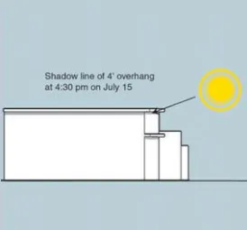
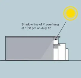
Summer Shade Patterns
Establish Attractive Connection to Haggin Oaks Golf Courses
Section titled “Establish Attractive Connection to Haggin Oaks Golf Courses”The Haggin Oaks golf courses add a special amenity to the Plan area both visually and as complementary uses. Currently, the advantage of the proximity of the courses to the Boulevard is negated by the unattractive and outdated connection on the Fulton Avenue overcrossing.
The Plan area does not include the over crossing or any of the facilities on the north side of the freeway. However, the Plan area should facilitate future improvements to the overcrossing by requiring that the design of any public improvements in the vicinity of the Fulton Avenue intersection be related to the golf courses, perhaps with signage and/or other design elements.
Establish Enhanced and Attractive Pedestrian Connection to the Watt Avenue Light Rail Station
Section titled “Establish Enhanced and Attractive Pedestrian Connection to the Watt Avenue Light Rail Station”The light rail station is located approximately one-half mile north of the Plan area. The current uses in and around the Plan area do not have a strong relationship to the station. Nonetheless, access to the light rail station should be enhanced wherever the opportunity exists. In this Plan area, future redevelopment of the area around the Watt Avenue intersection could provide a nucleus of transit-supported businesses and high density residential uses.
The Plan area should provide an enhanced pedestrian connection on the west side of Watt Avenue and the south side of the Boulevard to improve access to the light rail station.
The design review of any proposed new development within onequarter mile of the Watt Avenue/West Auburn Boulevard intersection should consider high intensity uses. Inducements, such as, reduction of parking requirements or modification of the signage requirements may be considered to encourage the highest intensity of mixed use development that can be accommodated.
Any use of public funds for public improvements or support of redevelopment of these sites will require development to be of suf fi cient density to support public transit.
Establish Pedestrian Connections to Adjacent Neighborhoods
Section titled “Establish Pedestrian Connections to Adjacent Neighborhoods”The minor streets ( Howe Avenue, Bell Street and Morse Avenue) that intersect the Boulevard shall have strong pedestrian connections to the adjacent neighborhood. This shall include adequate sidewalks, shade trees and pedestrian-scale lighting on that portion of the street that connects the Boulevard to the neighborhood.
H. Urban Form Zones
Section titled “H. Urban Form Zones”The West Auburn Boulevard Plan Area includes distinctly different subareas or ‘urban form zones.’ These urban form zones are determined by many factors, most notably the physical setting, the adjacent land use, exposure to the freeway, local traffic, and existing land use.
Although the Special Plan Area Ordinance allows a mix of land uses to occur at any location along the Boulevard, there are some uses better suited to certain zones. These factors suggest that the land use and development standards should be based on different ‘urban form zones’ along the Boulevard.
These zones are described in the following sections and are identifiedin Figure 3-3.
Watt Avenue Zone
Section titled “Watt Avenue Zone”The intersection of Watt Avenue and Auburn Boulevard will remain a major regional transportation hub. Watt Avenue will continue to grow in regional significance as a major north-south corridor linking the Highway 50 corridor to I-80 and ultimately to the Placer Parkway near Roseville.
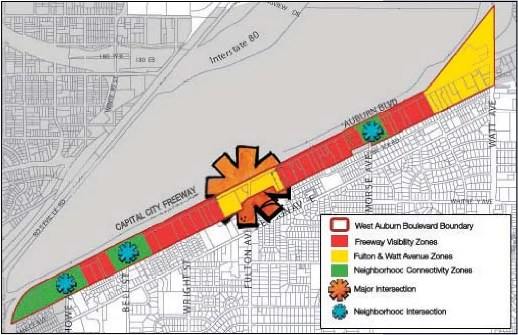

Urban Form Zones
As a major crossroads in the region, and located near the Watt Avenue Light Rail Station, the Watt Avenue/Auburn Boulevard intersection has the potential to develop as a high intensity core area. The Watt Avenue Zone would ultimately develop as a mix of office and high density residential uses. The intersection is also a primary gateway to the Arden-Arcade community and the commercial use core at Watt Avenue and El Camino Avenue. Future uses should take advantage of the transportation opportunities and provide a notable landmark gateway to the community to the south.
The development of this area should include taller mixed-use buildings that provide a landmark anchor for the West Auburn Boulevard corridor. Future development should be notable for its landscaping, signage and architecture.
Fulton Avenue Zone
Section titled “Fulton Avenue Zone”The intersection of Fulton Avenue and Auburn Boulevard offers a unique opportunity to provide a gateway to the Arden-Arcade community and a link to the golf courses to the north. The intersection is the geographical center of the Plan area and should be developed as a ‘center piece’ that links the West Auburn Boulevard Streetscape Master Plan improvements to the Fulton Avenue corridor.
Future development at this intersection should provide a visual connection to the existing design theme along Fulton Avenue to the south. Buildings should be taller than the adjacent uses and should provide landscaping and signage that relates to the overall design theme for the Boulevard.
Freeway Visibility Zones
Section titled “Freeway Visibility Zones”Certain locations along the Boulevard have much more direct exposure to the freeway and are much more suited to uses that benefit from high visibility. Retail uses are most likely, but certain other services and office uses would also select a high visibility location, if offered a choice. Land uses that benefit from high visibility and are less sensitive to freeway noise would be located in areas where the line of sight from the freeway is superior.
The development standards in these areas will favor high profile uses that benefit from freeway exposure. Buildings need not be tall, but will incorporate attractive design features that provide a pleasing impression of the West Auburn Boulevard district from the freeway.
Neighborhood Connectivity Zones
Section titled “Neighborhood Connectivity Zones”The adjacent residential neighborhoods to the south have very little relation to the businesses along the Boulevard due in part to the lack of mid-block connectivity. The existing neighborhood-serving uses tend to be clustered near the major street intersections (Watt Avenue and Fulton Avenue), but these are generally auto-oriented uses that do not favor pedestrians. The only notable exception is the small convenience retail outlet at Morse Avenue and the nearby Deseret Industries store.
One of the goals for this SPAO is to provide more connectivity to the adjacent neighborhood to encourage residents to walk to local retail and services. The development standards encourage development of pedestrian friendly, local service land uses along the Boulevard in the vicinity of Bell Street, Howe Avenue and Morse Avenue.
Higher intensity uses that would support and benefit from public transportation will be clustered within walking distance of existing public transit service. specifically, Regional Transit bus route 26 and the Watt Avenue Light Rail Station. The bus stops would be enhanced with shelters and improved access to the north side of the Boulevard for south-bound buses.
SECTION FOUR: Development Regulations
Section titled “SECTION FOUR: Development Regulations”Section Four details the Development Regulations including architectural standards, building size and proportion, building orientation, pedestrian paths, public transit access, security, driveways, parking, landscaping, lighting, signage and various other considerations.
A. Application of the Development Regulations
Section titled “A. Application of the Development Regulations”Applicants for new development or improvements to existing structures in the Plan area will apply the development standards described in this section. The SPAO is intended to be comprehensive and to replace the current zoning and land use regulations within this Plan area.
Where the SPAO is silent, the County’s Zoning Ordinance will apply.
The standards describe and provide for variations that allow for location differences (the urban form zones) and different building use types. All development standards will apply unless specifically noted as a special case that applies only to a location or a building use type.
B. Architectural Standards
Section titled “B. Architectural Standards”Coordinated Design
Section titled “Coordinated Design”- All exterior facade elements will reflect a coordinated design concept, including expression of building function, structure and scale;
- The use of materials, color and finishes will be coordinated to achieve a sense of continuity and quality in design.
Building Materials
Section titled “Building Materials”These design standards do not specifically limit the form or application of exterior finish materials and creative use of materials is encouraged. The intent is to create a Boulevard district that is notable for quality and contemporary design.
- Exterior materials will convey permanence and substance. Plastic materials meant to represent a natural material, such as stone or wood, are discouraged.
- The appropriate exterior materials include metal, glass, masonry, plaster, stucco, stone and decorative treatments in concrete or asphalt.
- Brick and concrete block used in traditional styles are inconsistent with the vision of a contemporary design district.
Colors
Section titled “Colors”The use of ‘appropriate’ color is highly subjective. The intent is to avoid large panels of primary colors that demand attention.
- Bright colors and primary colors are acceptable as accent colors. Primary colors should only be used to accent elements, such as, door and window frames and architectural details.
- Large areas of intense white color should be avoided.
- The color palette chosen for new structures should be compatible with the color palette established in the Streetscape Master Plan.
- Architectural detailing should be painted to complement the facade and tie in with adjacent features.
Architectural Lighting
Section titled “Architectural Lighting”Architectural lighting that provides drama and interest to buildings is consistent with the SPAO goal to create a landmark district. Consistent use of simple techniques or common elements, such as repetition of the lighting design applied to the landmark signage in the Streetscape Master Plan would establish a distinctive design character for the entire district.
- Consideration of both interior and exterior lighting shall be evident in the design of buildings fronting on the Boulevard.
- External night lighting will be used to enhance and articulate the buildings without glare directed off-site.
- Ground based up-lighting that washes the primary walls or highlights architectural features or detailing will be used on the facade fronting on the Boulevard.
- Lighting fixtures will not project above the fascia or roof line of the building and are to be shielded. The shields will be painted to match the surface to which they are attached. Security lighting fixtures are not to be substituted for parking lot, drive aisle, or walkway lighting fixtures, and are not restricted to lighting only loading and storage locations or other similar service areas.
- Wallpack lighting is discouraged on all facades facing the Boulevard or publicly accessible areas.
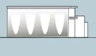
Accent Lighting Lighting washes on a plain wall can create distinctive forms.
Energy Conserving Design
Section titled “Energy Conserving Design”Energy conservation is implemented through building and landscape design, as well as the building orientation compatible with the climatic conditions.
- Passive solar design is encouraged whenever possible. Design of buildings will demonstrate consideration of energy-efficient concepts, such as natural heating and/or cooling, sun and wind exposure and orientation, and other solar energy opportunities.
- Natural lighting is encouraged.
- Life-cycle costs of buildings will be considered in all buildings.
- Use of thermal mass to moderate the heating and cooling of structures and public spaces will be considered in the design of all buildings.
- Application of the Leadership in Energy and Environmental Design (LEED) Green Building Rating System is encouraged.
- Solar collectors, if used, will be oriented away from public view or designed as an integral element of the roof structure.
- Sun shade structures such as building overhangs, verandas, trellises and porticoes will be incorporated in the design of all buildings at the primary entry and pedestrian approaches to all buildings.
Architectural Detailing
Section titled “Architectural Detailing”- Architectural elements that contribute to a building’s character, aid in climate control and enhance pedestrian scale are encouraged. Examples include: canopies, roof overhangs, projections or recessions of stories, balconies, reveals and awnings.
- Building entry ways will be clearly defined and integrated with building and landscape design. The use of distinctive architectural elements and materials to denote prominent entrances is required.
- Doors and windows will be consistent in design and located to present a unified appearance to the elevation except where the variations are an integral and necessary part of the exterior design.
- Simulated or blacked out windows are strongly discouraged.
- Buildings will incorporate detailing where it is discernible by pedestrians and motorists viewing the building from typical locations. Pedestrian scale features such as porticoes, arbors and promenades are particularly important.
- Walls adjacent to a walkway will include windows, trellises, wall articulation, wainscot, arcades, changes in materials or other features to ensure visual diversity and proper scale. Architectural detailing of each wall at ground level will relate to the landscape to ensure an appropriate transition of the building and the ground plane.
- Retail shops and offices fewer than 10,000-square-feet per tenant will include a minimum of 15 percent window front length adjacent to walkways along the ground floor wall. These windows will not be covered inside the building and will allow direct line-of-sight into the building from the nearest parking area or driveway.
- All roof top equipment must be screened from public view using materials of the same nature as the main structure. Mechanical equipment should be located below the highest vertical element of the building.
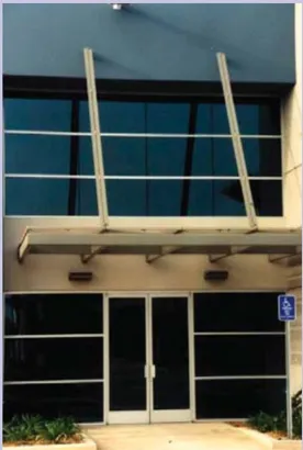
Simple banding and detailing can create visual interest on the simplest building.
C. Street Presence/Mass and Scale
Section titled “C. Street Presence/Mass and Scale”Street presence refers to how the building is perceived from the street. It encompasses the issues of building height, form, massing, detailing and articulation.
Building Height
Section titled “Building Height”The scale of buildings along the Boulevard should be grand rather than intimate. The Boulevard will include a pedestrian corridor along the south to side of the street, but the scale of buildings and landscaping will generally give priority to the view from a vehicle on the street. The perception of building scale differs greatly when one is a pedestrian a few feet from the building or a motorist on the freeway traveling at 50 mph.
- Building height will be regulated by the distance from the rear property line and by the distance from the intersections at Bell Street, Morse, Howe, Watt and Fulton Avenues. Buildings should be taller at the major streets (Watt and Fulton) to signal significant gateway landmarks. Conversely, the buildings should be lower at the intersections with streets that lead into the residential neighborhoods to present a pedestrian scale connection.
- Buildings adjacent to existing residential neighborhoods should that step down toward the rear to provide privacy for the existing residences, and to rise up near the major intersections to provide a landmark feature. Buildings may be up to four stories and 50’ high near the Boulevard, but will step down in height toward the rear so that no portion of a building may be more than two stories high within 50’ of the rear property line.
- Heights of structures should allow maximum natural light and ventilation, protection from prevailing winds, enhance public views and minimize obstruction of view from adjoining structures.
- Height and scale of new development should provide a ‘transition’ from the height of the lowest adjacent development to the maximum height of the proposed structure.
- In each cluster building use type a single building or portion of a building not to exceed 400-square-feet in area may extend up to 50’ in height. The building may be used as a clock tower, bell tower or other similar purpose. The intent is to provide a visual focal point near the common area.
Building Heights Permitted
| Distance from | Distance (feet) | Stories | Height (feet) |
|---|---|---|---|
| Watt Avenue* | 500’ | 6 | 70’ |
| Fulton Avenue* | 500’ | 6 | 70’ |
| Bell Street, Howe and Morse Avenues | 200’ | 2 | 25’ |
| Rear Property Line | 50’ | 1 | 15’ |
| Rear Property Line | 100’ | 2 | 25’ |
| Rear Property Line | 150’ | 3 | 40’ |
| Rear Property Line | 250’ | 4 | 50’ |
*Height allowed relative to Watt Avenue and Fulton Avenue shall supersede height allowed from rear property line.
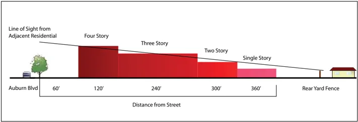
Proposed Permitted Building Height Section

Proposed Permitted Building Heights - Axonometric
Building height would increase from rear toward the front of a typical lot.
Building Mass and Proportions
Section titled “Building Mass and Proportions”- Architectural elevations should employ the ‘Golden Proportion’ in the proportion of major building elements, window and door frames, columns or other vertical elements. Multiple uses of the Golden Proportion in several buildings along the Boulevard will create a subtle sense of continuity despite different building materials and styles.
- Large dominating structures should be broken up by: 1) creating horizontal emphasis through the use of trim; 2) adding awnings, eaves, windows, or architectural ornamentation; 3) use of combinations of complementary colors; and 4) landscape materials.
- Large expanses of walls will be articulated with a combination of small and well defined sections, architectural detailing, color and/or composition of facade elements.
- Wall surfaces in buildings less than 50’ in height will avoid running in one continuous direction greater than 100’ without an articulation feature such as a pilaster, offset, or change of color or material.
- Multi-story buildings should have a window line on the upper floors. Notably, retail stores, such as furniture stores are encouraged to use the upper floor window areas for display of the offered goods.
- The roof line at the top of the structure should incorporate offsets and jogs to reduce the monotony of an uninterrupted roof plane.
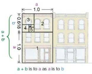
Golden Ratio
D. Relation to the Street (Front Setbacks)
Section titled “D. Relation to the Street (Front Setbacks)”The general intent is to establish a building setback from the street to provide adequate space for a landscape and parking area and/or a display of vehicles for sale. The standard setback would ensure that no building would block the view of the neighboring building or vehicle display area. However, variation in street setback would provide visual interest to the streetscape and allow better use of the site for smaller buildings.
The front setback for all buildings will be established by a vision triangle measured relative to the side property line and the back of side walk. The front setback will be defined by a line located at a 45-degree angle to the side property line beginning at a point 60’ along the side property line measured from the back of the sidewalk. However, a building may be located within the front setback area provided that the front setback line at the edge of the adjacent property is visible at a distance of 200’ from the side yard property line.
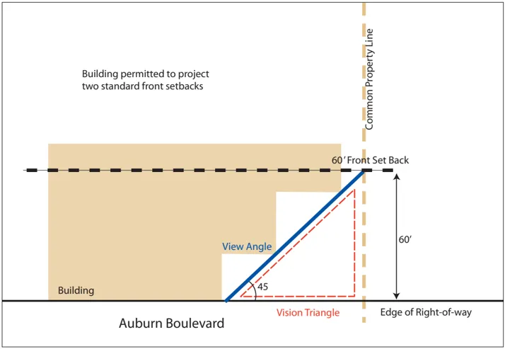
Proposed Front Setbacks (Plan View)
E. Streetscape and On-Site Landscape Interface
Section titled “E. Streetscape and On-Site Landscape Interface”The front setback area may include a public improvement, such as a sign or light standard that is part of the streetscape. The location and dimensions of these improvements is specified in the Streetscape Master Plan. The County will have the right to acquire the land for these improvements and expand the public right-of-way.
Autos for sale may be placed on a raised platform or on a berm that is not more than four feet higher than the adjacent parking area. Such berms or platforms will not occupy more than 20’ of any single dealership frontage and shall be constructed of materials consistent with these regulations and streetscape materials.
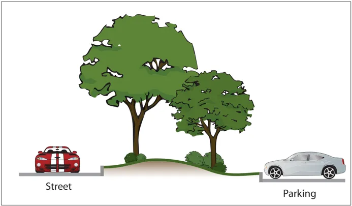
Proposed Landscape Buffer
Relation to Adjacent Use (Rear Yard Setbacks)
Section titled “Relation to Adjacent Use (Rear Yard Setbacks)”The rear property line abuts a residential use in virtually all cases. The rear property line standard is intended to provide privacy for the adjacent residential uses and security for both the residential and non-residential uses.
The existing conditions include buildings located at the rear property line on many of the lots. A utility line runs along the rear property line of most locations. This precludes the use of trees to screen the adjacent use. Therefore, the rear property line of all properties will provide an eight foot high masonry wall. A planting strip not less than eight feet wide will be provided along the base of the wall. The plant materials should include low shrubs and climbing plants to screen the wall. Trees should be planted where possible.
Relation to Adjacent Use (Side Yard Setbacks)
Section titled “Relation to Adjacent Use (Side Yard Setbacks)”All non-residential buildings have no side yard setback requirement. However, each developed parcel will provide a minimum 20’ wide fire access corridor extending from the front property line to within 100’ of the rear property line. The fire access may be a driveway or landscaped area and may be located at any point along the property frontage including the side yard.
Residential uses will provide a minimum 10’ side yard.
F. Site Design and Building Orientation
Section titled “F. Site Design and Building Orientation”- Structures should be sited in a manner that will compliment the adjacent structures. Sites should be developed in a coordinated manner to provide order and diversity to avoid a jumbled, confused development.
- Locate structures and on-site circulation systems to minimize pedestrian/vehicle conflicts. Enhance the sidewalk with textured paving, landscaping and trellises where feasible.
- Locate loading facilities at the rear of the building. Loading docks and doors must be screened from the street.
- Whenever possible, new structures should be clustered to create plazas or pedestrian malls and prevents long ‘barracks-like’ rows of structures. A visual link between separate structures should be established through the use of an arcade system, trellis or other open structure.
- Cluster uses will include a well defined public space, such as a plaza or pedestrian mall. The common public area will provide an area not less than two percent of the total leasable floor area of the site and will be designed to accommodate tables and benches for outdoor dining and casual seating, as well as carts for outdoor vending. Such areas may be allocated to a specific use, such as a restaurant.
- Each retail center will provide a primary walkway linking all stores and shops. The primary walkway will have a minimum width of eight feet adjacent to retail and fi ve feet in parking areas and pedestrian scale lighting to promote evening use.
- A tree canopy should be provided over the parking area, but allow the primary entry to be seen from the street. The County’s Shade Tree Ordinance will be adhered to in all cases.
G. Pedestrian Paths within Parking Areas
Section titled “G. Pedestrian Paths within Parking Areas”- Building entry zones will be clearly defined through the use or combined use of elements such as accent paving, planting, color pots and bollards.
- Multi-family residential uses in a mixed use project will have a building entry separate from the non-residential uses.
- Enhanced paving, striping or other distinguishing design feature should be used selectively on the primary walkway and the common areas to emphasize special areas and to guide pedestrians.
- Separate vehicular and pedestrian circulation systems should be provided. A clearly defined fi ve foot pedestrian way separated from vehicle traffic will be provided through the parking area to a primary building from the sidewalks along the adjacent streets.
- Within parking areas the pedestrian path should be parallel to moving cars to minimize the need for pedestrians to cross parking aisles and landscape areas.
- Bicycle racks or lockers should be located in highly visible and convenient areas, but will not obstruct the pedestrian walkways.
- Site layouts will be designed to provide pedestrian access from the off-site pedestrian circulation systems to residential units and common area facilities that minimize conflicts with vehicles to the greatest extent possible.
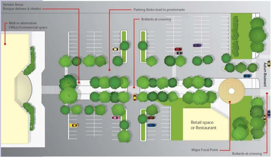
H. Public Transit Access
Section titled “H. Public Transit Access”- Commercial developments adjacent to a public transit route will provide a paved direct sidewalk from the primary facade of the major building to the sidewalk along the Boulevard leading to a transit stop. Where multiple buildings are included in the development each building with a gross floor area over 50,000square-feet will provide a connecting path that permits occupants to easily walk to the nearest transit stop.
I. Security
Section titled “I. Security”- Defensible space design techniques will be incorporated in all areas. Dense landscaping near structures and on the periphery of parking areas will be limited in order to maintain view corridors.
- Locate potential crime risk uses, such as automatic teller machines in highly visible and well-lighted areas.
- Maximize the visibility of parking area entrances from adjacent uses and public streets.
J. Internal Driveway Circulation
Section titled “J. Internal Driveway Circulation”- At the main entry to building entries, short-term parking for delivery and service vehicles will be provided such that they will not block pedestrian and vehicle circulation routes.
- Parking areas will be designed to provide space for unloading delivery trucks and to allow delivery trucks to head rather than back on to the street.
- Loading and unloading delivery vehicles in the street or in the median will not be permitted on the Boulevard.
- Internal driveways that connect between parcels, particularly of deep and narrow shaped parcels, are encouraged to minimize the number of driveways on the Boulevard and provide improved access to the rear of these parcels.
- Where parking areas are connected, direction of travel and parking bays should be similar to reduce conflicts at points of connection.
- On-site circulation should be designed to discourage speeding by avoiding long straight drives where conflicts with pedestrians and parked cars can occur. Speed bumps are strongly discouraged.
- Side or rear loaded delivery bays (and associated service/refuse areas) are preferred to front loaded delivery bays and should be screened from the pedestrian ways by a wall and/or landscaped berm.
Common Access Driveways
Section titled “Common Access Driveways”The number of relatively narrow properties along the Boulevard suggests the need to consolidate driveway entries to minimize the number of turning movements on the street.
- Shared access drives between adjacent parcels are encouraged to minimize curb cuts.
- Shared parking facilities between compatible adjacent uses are encouraged.
- Common driveways which provide vehicular access to more than one site are encouraged. The number of access driveways should be limited to the minimum amount necessary to provide adequate circulation.
- Shared parking between adjacent businesses and/or developments is encouraged whenever practical.
K. Parking Requirements
Section titled “K. Parking Requirements”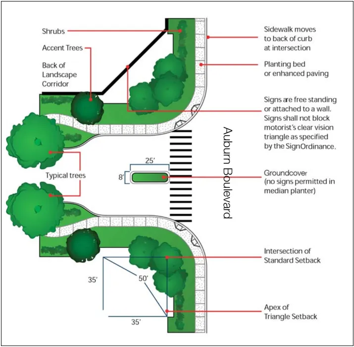
Proposed Typical Entry
On street parking will not be permitted on West Auburn Boulevard.
Parking standards, particularly the number of parking spaces required to accommodate a certain type of activity, are based on the activity rather than the type of building. Therefore, the form-based zone must rely on conventional parking requirements. However, the configuration of parking areas can relate to the form-based zone.
This section addresses the configuration of parking areas, rather than the number of parking spaces required. The majority of uses on the Boulevard will require conventional parking areas and on-site circulation (driveways and loading areas). Off-street parking will conform to ‘Chapter 30: Off-street Parking’ in the County Zoning Ordinance to ensure that off-street parking spaces and loading spaces are suf fi cient in number to accommodate all vehicles which will be congregated on a property.
- Multi-family residential uses in a mixed use project will have a separate parking area from the non-residential use secured in a manner that precludes non-resident vehicles from entering.
- Parking areas will be provided in the front of the building for customers.
- Parking areas will provide suf fi cient space to park and unload transport vehicles. Transport unloading in the street is prohibited.
L. Landscaping and Site Improvements
Section titled “L. Landscaping and Site Improvements”Landscaping
Section titled “Landscaping”The landscape will establish an overall image and visual order, provide shade in the summer; allow solar gain in the winter; buffer particular uses, and guide and direct views. Public walking areas, including plazas and courtyards between buildings typically will be covered with hard surface paving and the landscaping will be in distinct planting areas. Tree placement will be organized to define walkways and public spaces.
These standards are intended to provide a neat and well-maintained appearance in areas not covered by buildings or parking, to enhance the existing site character in order to minimize the adverse visual and environmental impacts of large paved areas and to conserve water.
- In locations away from building facades, the primary walkway will be lined with deciduous canopy trees or comparable shade structures to shade the walkways and gathering areas.
- Landscaping for commercial uses should define entrances to buildings and parking lots, provide transition between neighboring properties (buffering) and provide screening for loading and equipment areas.
- Landscaping should be in scale with adjacent structures and be of appropriate size at maturity to accomplish its intended purpose.
- Landscaping around the entire base of structures is recommended to soften the edge between the parking lot and the structure. This should be accented at entrances to provide focus.
- Deciduous shade trees will be planted to shade sidewalks. These trees will be placed at least 15’ away from the face of any building wall.
- Landscaping should be protected from vehicular and pedestrian encroachment by raised planting surfaces, depressed walks or the use of curbs.
- The use of vines and climbing plants on buildings, trellises and perimeter garden walls is strongly encouraged.
- Plants in boxed, clay or wood containers should be used for enhancement of sidewalk shops, plazas and courtyards.
- At maturity, trees should provide a shade canopy for all parking areas (other than auto sale lots).
- Landscaping should not obstruct visibility at drive aisle intersections.
- Bollards may be placed to control vehicular traffic and pedestrian fl ow adjacent to the parking area.
- Enhanced paving, striping or other distinguishing design feature should be used selectively at building entry areas, on the primary walkway and the common areas to emphasize these areas and to guide pedestrians. Examples of enhanced materials include pavers, stamped concrete, stained or integral colored concrete, scored patterns, and special finishes such as exposed aggregate.
Walls and Fences
Section titled “Walls and Fences”- If not required for a specific screening (i.e. security or separation of incompatible land uses) walls should not be utilized within commercial areas.
- When used, walls should be designed to blend with the site’s architecture. Both sides of all side-yard walls or fences should be architecturally treated. Landscaping should be used in combination with all walls.
- Security fencing and long expanses of fence or wall surfaces should be architecturally designed to prevent monotony.
Site Lighting
Section titled “Site Lighting”Lighting should be used to provide illumination for the security and safety of on-site areas such as parking, loading, shipping, receiving, pathways and working areas.
- Architectural lighting should provide functional lighting for the safety of pedestrian movement.
- The design of light fixtures and their structural support should be architecturally compatible with the main structures on site. Light fixtures should be integrated within the architectural design of the structures.
- All building entrances should be well lighted.
- All lighting fixtures must be shielded to con fi ne light spread within the site boundaries.
- Site lighting will provide a safe pedestrian-friendly environment.
- Lighting in pedestrian areas will use a common light fi xture compatible with the buildings and will not exceed 12’ in height.
- Light standards for parking areas will not exceed 20’ in height.
- Lights in parking lots will not be co-located with trees in planters. The lighting and landscape plan must be fully integrated and coordinated.
Refuse Collection, Utility Service Areas and Outdoor Storage
Section titled “Refuse Collection, Utility Service Areas and Outdoor Storage”The utilitarian elements of the site plan, including outdoor storage, utility service areas, and refuse collection areas are to be screened from the public use areas and streets by a solid wall. The wall will be constructed of the same material and have same finish material and color as the primary building. The height of merchandise, materials, and equipment stored or displayed will not exceed the height of the screening fence or wall.
- Any outdoor equipment whether on a roof, side of a structure or on the ground, must be appropriately screened from view. The method of screening must be architecturally integrated with the adjacent structure in terms of materials, color, shape and size. Where individual equipment is provided a continuous screen is desirable.
- All refuse storage areas will be self-contained to prevent spillage or leaching of liquids or other materials into underlying soils and designed to contain all refuse deposited between collections.
- Planters around trash enclosures are strongly encouraged. The use of shrubs and vines on enclosure walls provides an opportunity for additional green space as well as mitigates for graffition enclosure walls.
- Auxiliary buildings, such as kiosks, maintenance sheds or maintenance buildings visible to customers shall complement and integrate the design characteristics applicable to the larger buildings.
Storm Water Management / Water Quality Enhancements
Section titled “Storm Water Management / Water Quality Enhancements”Water quality features that settle and fi lter run-off from streets and parking lots will be incorporated in project site design.
- The water quality features should be treated as a landscape design feature.
- Grassy swales and other best management practices are encouraged to fi lter storm water.
M. Signs and Graphics
Section titled “M. Signs and Graphics”Outdoor Graphics
Section titled “Outdoor Graphics”Public art in this SPAO can include murals, fountains, and sculpture of various types. The intent is to provide attractive visual elements that relate to the commercial uses in the area and the character of the community.
- Sculpture should be scaled to be clearly visible and notable from the freeway.
- Kinetic sculptures that move in response to wind, thermal changes or other natural forces are highly desirable. However, the motion of sculpture should not be frenetic or otherwise distract drivers.
- Art should not be clearly identifiable with a single manufacturer or product. However, art that relates to the ‘Inventors Row’ design concept is encouraged.
- Public art in the form of murals and/or three dimensional relief sculptures may be attached to a building or screen wall. Art in these forms does not count against the allowable signage for that building or use.
The sign regulations are intended to eliminate excessive and confusing sign displays, preserve and enhance the appearance of the Plan area. The SPAO will include a variety of businesses with different advertising needs and different architectural styles. There is no need to establish a single design standard or theme that applies to all businesses, doing so could possibly con fl ict with the style of the individual buildings. The SPAO encourages distinctive and creative signage that is integrated and harmonious with the buildings and site.
Common Sign Program for the Streetscape
Section titled “Common Sign Program for the Streetscape”The sign program provided in the Streetscape Master Plan is the common signage element that will visually connect all properties and businesses in the SPAO. This Plan includes a signature blade sign that will identify the SPAO as a distinctive district. The signature signs will be located at intervals specified in the Streetscape Master Plan at the edge of the public right-of-way on the south side of the street. The County will have the right to acquire the land for these improvements and expand the public right-of-way.
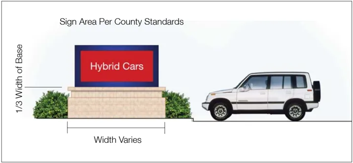
Proposed Typical Sign
Signs within the West Auburn Boulevard SPAO will be regulated by the Sacramento County Zoning Ordinance Chapter 35: Sign Regulations except as specifically provided in this section.
The SPAO is within the Arden-Arcade community Special Sign District and is subject to the provisions of Article 5: Special Sign District except as provided in this SPAO.
The SPAO is also within Interstate-Business Route 80 Special Sign Corridor. However, it is not subject to the provisions of Article 3: Special Sign Corridors. The Special Sign District regulations of Article 5 prevail.
- Each commercial site developed as an Auto, Large Box, Cluster or Residential and Residential/Mixed Use Building type will have a Master Signage Plan to ensure quality and continuity of appearance.
- Monument-type signs are the preferred alternative for business identification.
- Each site should be appropriately signed to give directions to loading and receiving areas, visitor parking and other special areas.
- The wording of signs may describe the products sold provided that the sign is compatible with the character of the sign program and complies with all other standards. No sign makers’ labels or other identification will be permitted. Signs will identify and locate rather than advertise and sell.
- Building signs will be integrated into building architecture and composed of materials compatible with the materials of the building.
- Banners, flags, pennants, shields and other graphic art that is part of a Master Signage Plan will be permitted subject to a design review. (Amends Section 335-09 [l and m], Prohibited Signs).
- Moving or rotating signs that rotate at less than 10 revolutions per minute or repeat a complete movement cycle at less than fi ve repetitions per minute shall be permitted. (Amends Section 33509 [a and b], Prohibited Signs).
- Inflatable or lighter-than-air devices of any kind including: those depicting animals, characters or vehicles when attached or secured from the ground or to any object on the ground or to any tree, building, sign or other built surface are prohibited. (Amended 11/90) (Amends Section 335-09[h], Prohibited Signs).
- Painted window signs and printed signs that obscure more than 20 percent of the window area shall be prohibited.
- Electronic message signs are regulated per County Zoning Code.
SECTION FIVE: Streetscape Master Plan
Section titled “SECTION FIVE: Streetscape Master Plan”Section Five provides specific recommendations for aesthetic and infrastructure improvements to West Auburn Boulevard. These improvements are intended to elevate the image of the Plan area and establish a framework for redevelopment into a signature business address and regional commercial destination.
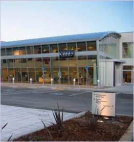
Niello Audi Dealership - 2006
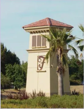
Fulton Avenue Landmark - 2003
A. Scope and Intent of the Project and this Document
Section titled “A. Scope and Intent of the Project and this Document”In conjunction with the Special Planning Area Ordinance, the Streetscape Master Plan recommends specific improvements throughout the Plan area. This Master Plan details streetscape improvements that can be undertaken over time, in a phased approach, allowing for the natural course of economic improvement to guide subsequent implementation phases.
B. Design Approach
Section titled “B. Design Approach”A broad and eclectic group of destination-based businesses either already exist along the Boulevard or are encouraged. The consensus among local business owners, the Technical Advisory Committee, stakeholders, designers and consultants is that the design approach should capitalize on the burgeoning economic growth and integrate the Boulevard’s historic significance with contemporary commercial uses, which are currently dominated by auto dealerships and complementary businesses such as hotels. Highlighting the Boulevard’s historic significance and current commercial uses in an interpretation that is modern, but not trendy, will transform the Boulevard into a viable commercial destination.
The design approach for the West Auburn Boulevard Streetscape Master Plan centers on six key elements:
- Unify the character of the Boulevard;
- Clean up the street right-of-way and adjacent freeway frontage;
- Enhance visibility to and from the freeway;
- Increase pedestrian accessibility and safety;
- Improve vehicular safety;
- Preserve West Auburn Boulevard’s historic and commercial integrity.
Unify the Character of the Boulevard
Section titled “Unify the Character of the Boulevard”The Master Plan focuses on creating a unified street character by incorporating a consistent aesthetic that complements adjacent land uses and architectural character.
New signage will be used to create a unified aesthetic throughout the Plan area. These elements will be created using consistent materials that blend with existing streetscape areas and provide a framework for the hardscape palette.
The existing chain link fence that separates eastbound traffic on the freeway from the Boulevard will be replaced with a ‘K-rail’ capped with decorative fencing. The K-rail and fence may integrate public art, further enhancing the unique character and a consistent edge to the Plan area and enlivening the boundary between the Boulevard and the freeway.
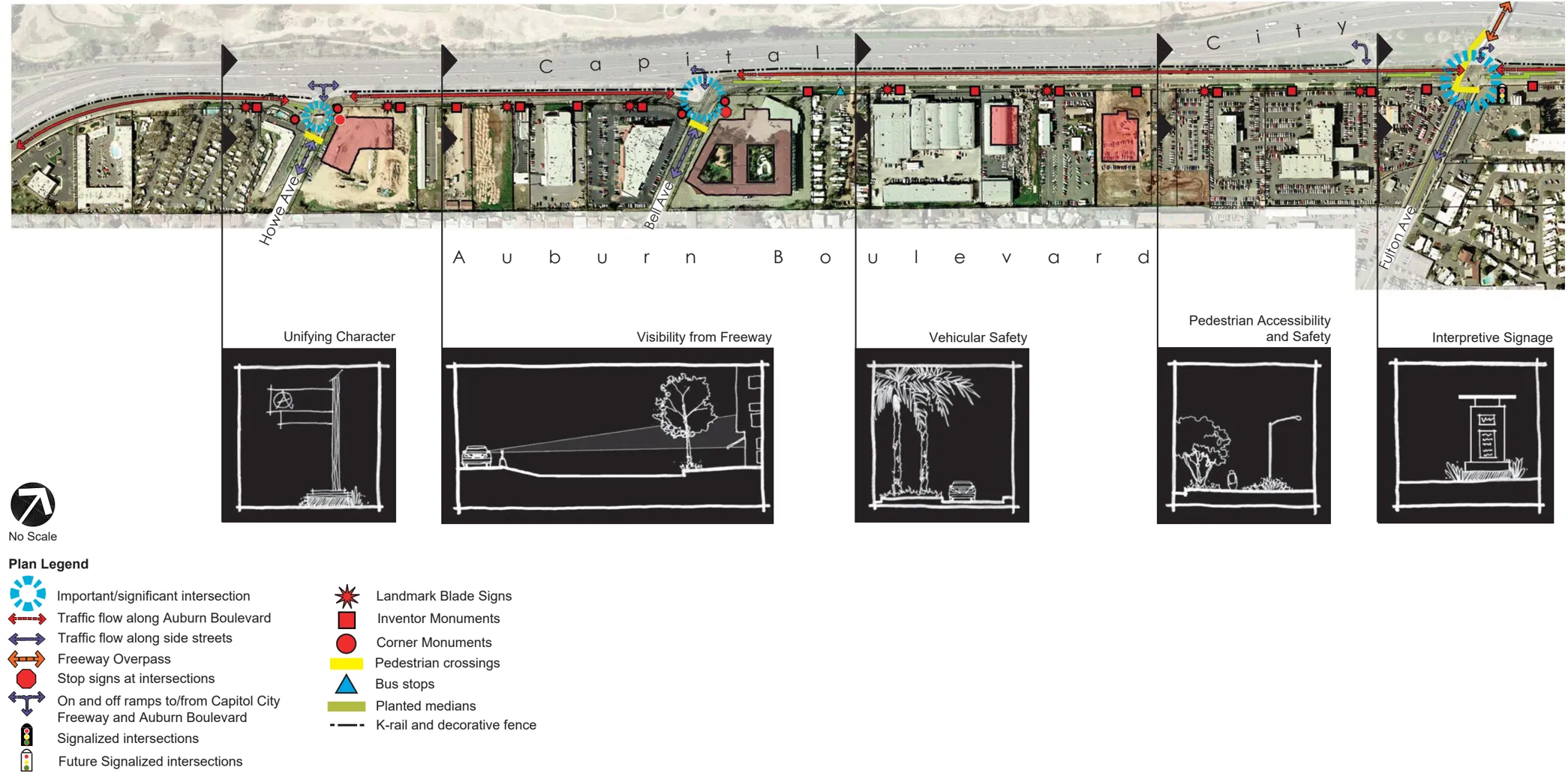
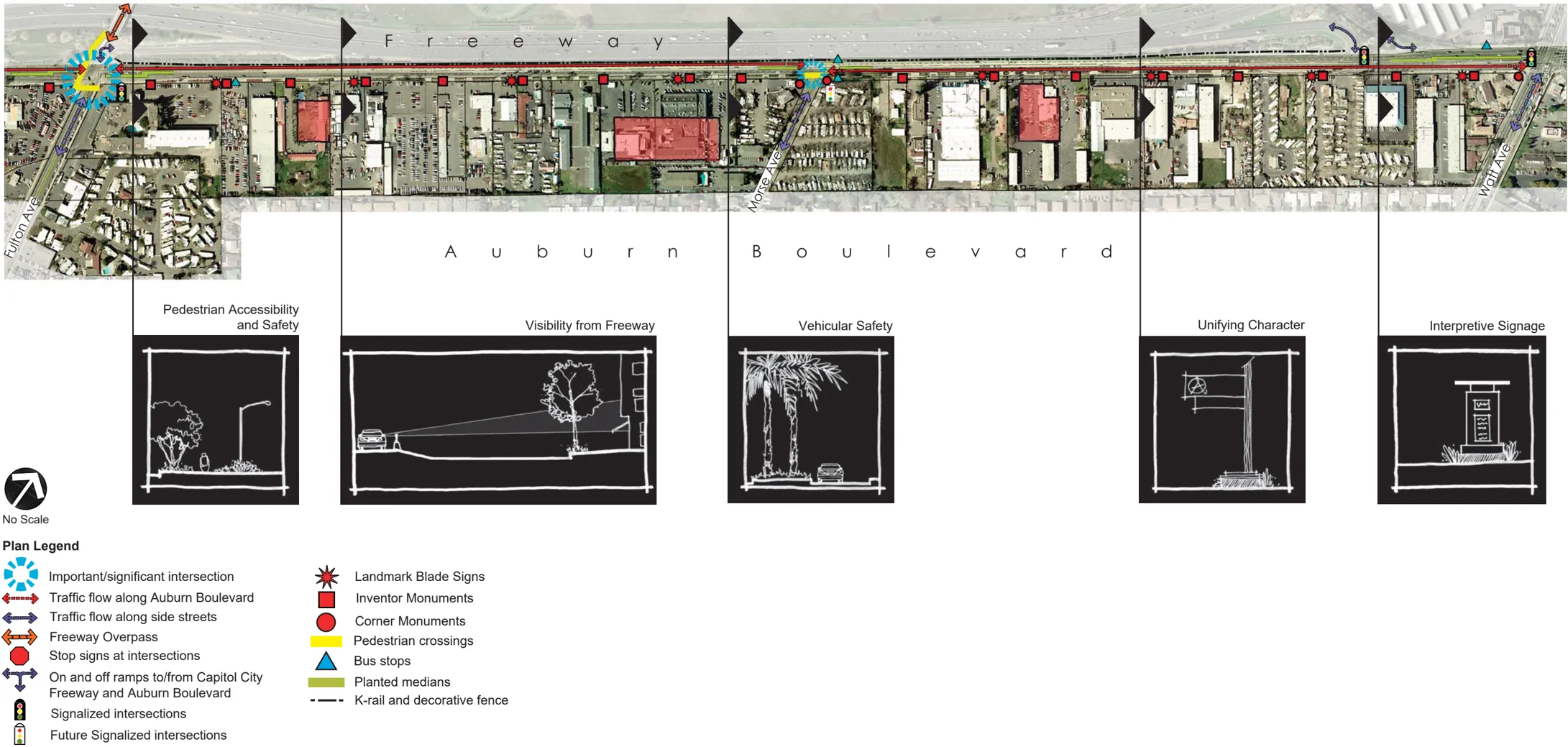
It is recognized that the street could accomodate landscape medians within the current right-of-way. However, property owners have expressed a serious concern with the inclusion of landscape medians within the project areas as it relate to accessibility to parcels and the potential impacts to current and future businesses. Prior to any consideration of the suitability of medians within the West Auburn Boulevard Proect area, the County and SHRA will develop a precess to engage the property owners and the public to consider the issue. Iclusion of landscape medians will only be considered upon full ensuring that each location does not obstruct parcel accessibility or cause undue harm to current or potential businesses.
Since pedestrian walkways run parallel to the street on its south side, the Master Plan recommends that south right-of-way frontages be improved to allow for six foot wide sidewalks, as required by the County of Sacramento’s Pedestrian Design Guidelines. Where required, existing sidewalks should be upgraded to maintain consistency along the entire street. Most of the Boulevard already includes a separated sidewalk condition. This sidewalk alignment is to remain and is encouraged, where viable, elsewhere along the Boulevard.
Key elements of the Boulevard-signage, plantings and plant palette and hardscape materials-should be designed to be modern, but not trendy. This could be construed as a European design aesthetic: clean lines and simple forms, focusing in depth on mass and scale rather than accent pieces or fussy details, but with classic materials and colors such as stainless steel and navy and red. The Niello Dealership constructed in 2006 sets the tone for the desired design aesthetic.
Clean Up the Street and Adjacent Freeway Frontage
Section titled “Clean Up the Street and Adjacent Freeway Frontage”Maintenance within the Plan area is critically important to improve the quality of the street environment and to attract new businesses, as well as customers to existing businesses. West Auburn Boulevard has long suffered from inadequate maintenance, giving it an overlooked, forgotten appearance. A key component to making this Plan viable is to establish regular maintenance practices and code enforcement activities. A maintenance plan must be created with the adoption of the improvement plan to implement on-going maintenance practices.
Public realm improvements recommended in this Plan are geared toward ease of maintenance into the future. For example, the Plan includes installation of curb and gutter along the north side of the street to allow for street sweeping on a regular basis. In addition, the proposed ‘K-rail’ and adjacent decorative paving will be easy to maintain. All recommended improvements must have low life cycle costs.
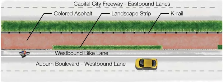
Typical K-Rail placement
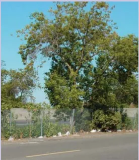
Poor maintenance plagues Auburn Boulevard
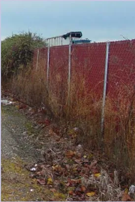
An unsightly Caltrans fence hinders views of the Boulevard from the Capital City Freeway
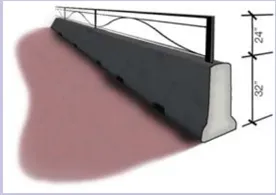
Typical K-rail with decorative fence
Enhance Visibility To and From the Freeway
Section titled “Enhance Visibility To and From the Freeway”Capital City Freeway, the stretch of I-80 adjacent to West Auburn Boulevard, is one of the most heavily traveled commuter corridors in the region. Improving visibility to West Auburn Boulevard from the freeway in a manner that attracts people to leave the freeway and patronize businesses along the commercial corridor is a key strategy supported by the Master Plan.
Stakeholders along the Boulevard have expressed their concern over how their businesses are currently seen from the freeway and how improvements to the streetscape could enhance or detract from this marketing opportunity. Plan area residents and business owners alike have stated their distaste for the unattractive chain link fence and haphazard landscaping that dominates the view of West Auburn Boulevard from the freeway. The Master Plan addresses these issues through a number of recommendations which are further detailed.
- Underground utilities as much as possible to improve the quality of the view to current and future businesses;
- Allow for a variety of alternative tree placements along the street frontage and in medians to maximize visibility for each business;
- Replace the chain link fence along the north side of the street with a K-rail and decorative iron fencing;
- Provide decorative paving combined with limited plantings between the K-rail and the street curb to address maintenance issues;
- Use high quality, enduring materials that contribute to a positive image throughout the Plan area and will improve the quality of the view along West Auburn Boulevard and from the freeway.
Increase Pedestrian Accessibility and Safety
Section titled “Increase Pedestrian Accessibility and Safety”While movement along West Auburn Boulevard consists primarily of vehicular traffic, the ability for pedestrians to travel safely and easily along the Boulevard and across the street is an important issue that was raised by all stakeholders. Pedestrian access from the surrounding neighborhoods to businesses on the Boulevard was recognized as equally important. To facilitate accessibility, walkways have been extended along the entire length of the street and down intersecting cross streets within the Plan area. Access for persons of all abilities will be provided by conforming walkways, ramps and landings to ADA and Title 24 guidelines.
- The County’s Bikeway Master Plan calls for bike lanes in both directions of Auburn Boulevard. County standards require that bike lanes be provided at a minimum width of fi ve feet. This standard shall be implemented on both sides of the Boulevard. This standard shall be implemented on both sides of the Boulevard; however, the bike land width shall be widened to nine feet at bus stop locations.
- Four bus stops currently exist in the Plan area. Three stops are on the south side and one is on the north side of the Boulevard. The stop on the north side is currently located mid-block and has no accessible route of travel to it. This stop, and the reciprocal stop on the south side, will require relocation to the Morse Avenue intersection to ensure accessibility. Shelters should be added to all bus stops.
- Existing traffic signals may require upgrading and the Morse Avenue intersection will require a new traffic signal due to increased pedestrian activity.
- Street lighting currently exists along much of the Boulevard, but there are a number of areas where it does not meet current improvement standards. Existing lights require maintenance, replacement and/ or improvement. This Plan requires that existing streetlights be upgraded to meet current standards and that new streetlights be installed where needed to provide adequate and consistent lighting along the entire street. Streetlights and traffic signals will also be painted to provide a consistent color theme along the Boulevard.
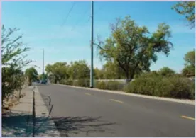
Existing sidewalk locations hinders pedestrian safety
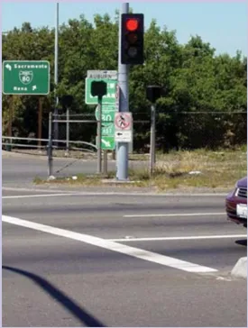
Poor crosswalks configurations limit pedestrian access to and from West Auburn Boulevard
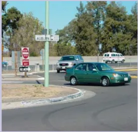
Current off-ramps from the Capital City Freeway disrupt traffic flow along West Auburn Boulevard
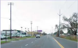
Power lines detract from the Boulevard’s appearance
Improve Vehicular Safety
Section titled “Improve Vehicular Safety”Motorist safety and ease of mobility are paramount when planning for improvements to the West Auburn Boulevard streetscape. Businesses rely on easy access for their customers as well as for employees and vendors. Buses need the room and opportunity to pick up and drop off passengers at convenient locations. Retail businesses require adequate space for large trucks to maneuver and off-load their hauls. To improve vehicular safety and increase access to businesses, this Master Plan proposes to reorganize traffic circulation patterns along the Boulevard.
The current street configuration consists of lanes that are much wider than current standards and projected future uses require. Lanes are generally 15’ to 17’ wide and, depending on the location, two to four lanes with a center turn lane. Curb and gutter exists along much of the south side of the Boulevard. The north side of the Boulevard generally includes a gravel shoulder and a sparsely planted area before being separated from the freeway by a chain link fence.
The Master Plan recommends that the street section be recon fi gured to decrease speeding and accommodate future vehicle needs, as well as the proposed bike lanes, medians and planting areas. Vehicular lanes will be restriped to 12’ in width and accommodate an 11’ middle turn lane/ median. While it will be necessary to maintain multiple lanes along the Boulevard as it nears the Watt Avenue intersection, it is recommended that, where possible, the street be reduced to two vehicular lanes, a center turn lands and two bike lanes. Prior to implementation of new capital projects that would reduce the number of lanes along Auburn Boulevard a traffic study justifying the new lane configuration shall be submitted to the Sacramento County Department of Transportation for review and approval. The traffic study should also address any locations where the ability for U-turns will be impacted.
Business owners voiced concern that suppliers with large vehicles may not have enough room to turn and maneuver if medians are placed in the center of the street and the number of lanes is reduced to one in each direction. The SPAO guidelines encourage the aggregation of smaller parcels along the Boulevard, as well as combining driveways from adjacent businesses into one common driveway. By eventually reducing the number of driveways, medians can be placed more frequently without affecting ingress and egress to businesses. The Streetscape Master Plan currently defines only those areas where medians can be placed immediately. Where these raised medians are shown, the bike lane on the south side of the Boulevard will allow for greater turn movement of large vehicles and passing through vehicles.
Great inventors are honored in the names of streets that intersect Auburn Boulevard
Bell

Edison

Morse
Preserve West Auburn Boulevard’s Historic and Commercial Integrity
Section titled “Preserve West Auburn Boulevard’s Historic and Commercial Integrity”West Auburn Boulevard was part of Highway 40 or the historic Lincoln Highway, the nation’s first transcontinental road. Until the addition of the adjacent I-80 in the early 1960’s, Highway 40 served as the primary connection between San Francisco and Lake Tahoe and was lined with many travel-oriented businesses. Several hotels and a few historic structures built during this period can still be found along the Boulevard.
The purpose of the Boulevard has changed since its inception as a throughway. Over time, the commercial corridor has emerged as a regional destination for lodging, purchasing a vehicle or unique items such as musical instruments and furniture. During the public planning process for this Master Plan, stakeholder groups concluded that this niche destination retail district could serve as the impetus for revitalizing the Boulevard.
Preserving the Boulevard’s historic value and unique features is an important aspect of the recommendations for improvements made in the Streetscape Master Plan and SPAO. The SPAO offers guidelines for improving private property that might contain these unique characteristics. The Master Plan builds on the SPAO by recommending that West Auburn Boulevard continues to be treated as a major transportation corridor and a destination for the region.
A unique feature within the Plan area is that major streets that intersect West Auburn Boulevard are named after prominent inventors. This feature can contribute to establishing a distinctive sense of place by incorporating each inventor’s background and contributions into interpretative signage and monumentation at each intersection.
The existing street character changes dramatically surrounding the intersection with Morse Avenue. In this area, several dilapidated structures exist, one of which is a vestige of West Auburn Boulevard’s past as Historic Highway 40. The community encouraged the redevelopment of this corner to include a mixed-use structure that would be fashioned more closely to the corridor’s historic character by including specific architectural features and site design. For example, a former gas station and wayside stop has been transformed into a convenience store and gas station with an adjacent restaurant and living quarters above. These structures could be rehabilitated in a fashion similar to Mills Station in Rancho Cordova.
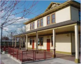
The Mills Station in Rancho Cordova is an example of how an historic structure can be preserved and reused to make a positive contribution to the character of Auburn Boulevard
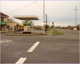
Intersection of Morse Avenue and Auburn Boulevard
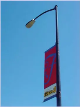
Street lighting will provide a safer atmosphere along Auburn Boulevard and create a unifying element affecting ingress and egress to businesses. The Streetscape Master Plan currently defines only those areas where medians can be placed immediately. Where these raised medians are shown, the bike lane on the south side of the Boulevard will allow for greater turn movement of large vehicles and passing through vehicles.
C. Detailed Improvements / Recommendations
Section titled “C. Detailed Improvements / Recommendations”The Master Plan recommends that enhancements for the entire Boulevard be addressed first, followed by additional improvements to particular sections of the Boulevard.
Specific improvements recommended for West Auburn Boulevard are divided into several categories:
- Infrastructure and utility improvements;
- Vehicular, bicycle, pedestrian circulation and transit improvements;
- Aesthetic improvements.
Infrastructure and Utility Improvements
Section titled “Infrastructure and Utility Improvements”- Underground all overhead utilities running along the south side of West Auburn Boulevard between Janice Street and Watt Avenues and, where applicable, when running perpendicular to the Boulevard along property lines or through the centers of parcels.
- Provide street lighting throughout the Plan area to ensure the County’s minimum standard of service. Painted cobra head streetlights are recommended. The use of painted cobra heads will lead to additional long term maintenance costs for the Sacramento County Department of Transporation. The creation of a Landscape and Lighting District as outlined in Section Six will help ensure future maintenance of the painted lights.
Vehicular, Bicycle, Pedestrian Circulation and Transit Improvements
Section titled “Vehicular, Bicycle, Pedestrian Circulation and Transit Improvements”Freeway Frontage
Section titled “Freeway Frontage”- Replace the existing chain link fence between the Capital City Freeway and eastbound traffic lane of West Auburn Boulevard with a ‘K-rail’ capped with decorative fencing. The K-rail fencing would reach a total height of just under fi ve feet; one foot lower than the current chain link fence. The decorative fence will be designed and maintained to appear relatively transparent, which will enhance the visibility to West Auburn Boulevard from the freeway. K-rail and fence can be used as a public art feature, provided that all Caltrans requirements are met.
- Decorative paving to match the decorative asphalt imprinted in the center turn lanes will be used in the width between curb and K-rail. In areas with greater than six feet in width, shrub planters material will be placed at regular intervals, separated by decorative paving. Additionally, a swath of paving will be provided between planting and K-rail to allow for easy removal of debris. The use of decorative paving the the center turn lane could lead to additional long term maintenance costs. In locations where utility companies need to trench beneath the pavement they are not required to replace decorative pavement in-kind. In future trench repair sections this will eventually result in an unsightly combination of decorative pavement and conventional asphalt concrete. It will be necessary to spend future maintenance monies to prevent this undesirable outcome. The creation of a landscape and lighting district as outlined in Section Five will help ensure the future maintenance of the decorative pavement.
- Provide four foot minimum width planting areas spaced equally, and/or decorative paving between K-rail and West Auburn Boulevard.
Approved decorative fencing and K-rail can enhance the Boulevard and contribute to traffic safety
Median/Center Turn Lane
Section titled “Median/Center Turn Lane”- Provide an 11’ enhanced center turn lane throughout the Plan area through the use of custom decorative imprinted asphalt.
- Where space and driveway access allows, provide a raised and planted median.
- Medians will consist of plant materials surrounded by a colored concrete maintenance border and separated from asphalt by a barrier curb, per Sacramento County improvement standards. All planted medians will require root barrier protection.
- Median noses and areas too narrow for plantings will be paved with concrete pavers.
- Center turn lane delineation markings will be provided by solid fi ll in the border of the decorative imprinted asphalt and reflective dots.
- Potential median locations will be analyzed and ultimately located in subsequent phases of design work (Streetscape Improvement Plans). Property owners along the Boulevard will be consulted in the decisions in where to place raised medians.
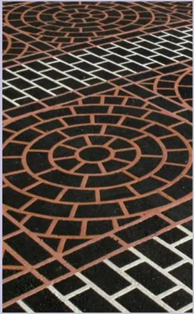
Duratherm decorative pavement will be used as an at-grade median where necessary, further unifying the character of West Auburn Boulevard
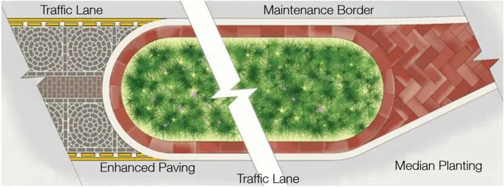
Typical median layout
Surfacing and Striping
Section titled “Surfacing and Striping”- Vehicular lanes will be restriped to 12’ in width and accommodate an 11’ center turn lane or strategically placed raised, planted median. While it will be necessary to retain a multiple lane configuration, it is recommended that, between Bell and Watt Avenue intersections, the street be reduced to two vehicular lanes (where possible), a center turn lane, and two bike lanes. Prior to the implementation of any capital projects that would reduce the number of lanes on Auburn Boulevard, a traffic study justifying the new lane configuration shall be submitted to the Sacramento County Department of Transportation for review and approval. The traffic study should also address any locations wher ethe ability to U-turn will be impacted.
- Resurface street paving with rubberized asphalt throughout the Plan area.
- Reduce vehicle lanes to 12’ width to allow for improvements.
- Provide curb and gutter along the north side of West Auburn Boulevard and in any locations within the Plan area that it does not currently exist.
Path of Travel Improvements
Section titled “Path of Travel Improvements”- All sidewalks along the Boulevard will be a minimum of six feet wide.
- Where space allows, sidewalks will be separated from the roadway by a planter strip of at least eight feet wide.
- Improve sidewalks to ensure uniform accessibility along entire street including curb, gutter, ramps and crosswalks.
- Provide signal improvements as required to ensure pedestrian improvements at all signalized intersections.
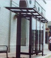
Bus stop shelters are oriented to face adjacent properties instead of the street
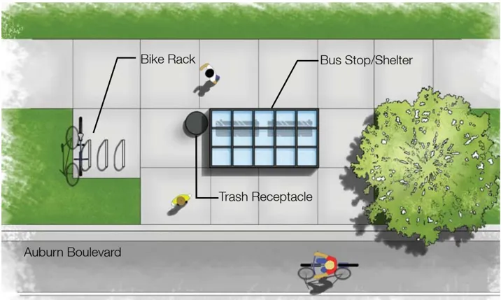
Typical bus stop layout
Bicycle Lanes
Section titled “Bicycle Lanes”- Six-foot wide bike lanes will be the standard implemented on the north side of the Boulevard. However, on the south side, the bike lane will be widened to eight feet where space is available to accommodate right hand turn movements and bus stop locations.
- Add bike lanes in both eastbound and westbound directions. East direction will be eight feet wide; west direction will be six feet wide.
Bus Routes / Stops
Section titled “Bus Routes / Stops”- All existing bus stops along the Boulevard will be enhanced with bus shelters, consistent benches, trash receptacles and bicycle racks.
- Bus stops will be oriented to face toward adjacent properties, with the back of the bus stop facing the Boulevard.
- The bus stops currently located at Deseret Industries will be relocated to the intersection at Morse Avenue to provide required accessibility across West Auburn Boulevard. Bus stop relocation should be concurrent with intersection signalization.
Street Amenities
Section titled “Street Amenities”- Add amenities to streetscape including benches, trash receptacles and bike racks.
- All existing bus stops along the Boulevard will be enhanced with bus shelters, consistent benches, trash receptacles and bicycle racks.
- Bus stops will be oriented to face toward adjacent properties, with the back of the bus stop facing the Boulevard.
- The bus stops currently located at Deseret Industries will be relocated to the intersection at Morse Avenue to provide required accessibility across Auburn Boulevard. Bus stop relocation should be concurrent with intersection signalization.
- Bike racks at a minimum of two locations within each block, equally spaced.
- Where limited tree planting space occurs, particularly in areas without separated sidewalk, provide street trees in tree grates.
Aesthetic Improvements
Section titled “Aesthetic Improvements”Signage / Monumentation
Section titled “Signage / Monumentation”- Fifteen large scale Landmark Blade Signs will be placed along West Auburn Boulevard. Signs are to be placed equidistant between high tension power poles, but at the back of the sidewalk so the impact of the blade signs is not diminished by the power pole. Each sign will be 40’ in overall height. The pole will be fiberglass and house blue tube lighting for dramatic impact at night. The sign will be constructed out of powder-coated sheet metal and mounted to the fi berglass pole in such a way as to mitigate wind and other environmental impacts. The pole will be painted to match stainless steel elements used on other areas of the Plan. The pole base will constructed of four foot wide brick and will also include a planted buffer surrounding three sides. This sign will require structural engineering and right of way acquisition.
- Seven monuments commemorating the inventors after whom the streets intersecting West Auburn Boulevard are named will be provided at appropriate intersections. Howe, Bell, Morse and Watt Avenue intersections shall all receive this monuments. Each monument will be 10’ in height and have a four foot square brick base. The general sign housing will be stucco, the primary street name will be lit and the sign itself created with a banked enamel/ porcelain finish. The top piece will be fabricated from stainless steel. This monument will require structural engineering, final graphic and signage design and right-of-way acquisition.
- Thirty-two pedestrian-level inventor monuments will be placed along West Auburn Boulevard adjacent to and equidistant between the Landmark Blade Signs. These monuments are intended to be placed within the planting strip between the curb and sidewalk (within the right-of-way) where available, but may require right-ofway acquisition where separated sidewalks are not feasible. These monuments will be no more than three feet in height and placed so that visibility from driveways is not impeded. Each monument will contain a portion of the story of the inventors. The monument will be constructed primarily of brick with a baked enamel/porcelain sign. This monument will require final graphic design and potential right-of-way acquisition.
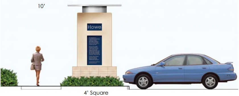
Typical street corner monument
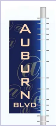
West Auburn Boulevard Proposed Blade Sign
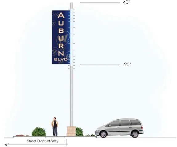
Blade Signs Visibility
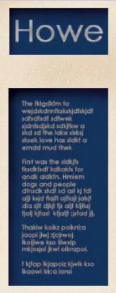
Proposed Interpretive Sign
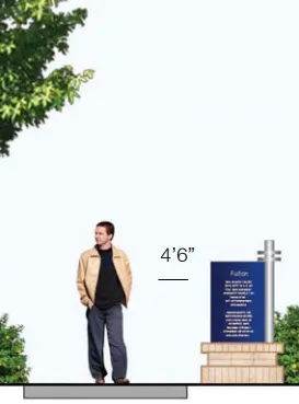
Proposed Inventor Monuments
Public Art
Section titled “Public Art”- Opportunities for public art will be incorporated into the K-rail along the north side of the street. Public art could take the form of interesting fence work above the K-rail and/or paint work or impressions on the K-rail itself. All artwork involving the K-rail or K-rail fence must be approved by Caltrans.
Landscape Treatments
Section titled “Landscape Treatments”- Street trees will be provided along the south side of the street in a separated planter strip, if available. These trees will be chosen from the approved street tree list, as included, and will be placed an average of 30’ on center.
- Accommodations will be made for the wider placement of street trees in front of businesses to allow for visibility, however these trees will not exceed 50’ on center. On properties where this is required, a larger grouping of trees will be mandated at property lines and/or driveways to reach the average spacing noted. Sight visibility in compliance with County standards will be maintained in all applications.
- Street trees in medians will be provided at a maximum spacing of 30’ on center.
- A low growing ground cover will be planted within the parkway strip on the south side of the street.
- All street tree locations will require continuous root barriers along the length of curb and/or sidewalks to deter cracking from tree roots and irrigation water damage.
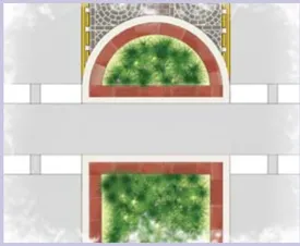
Cross walks at median
D. Street Section Recommendations
Section titled “D. Street Section Recommendations”West Auburn Boulevard - Capital City Freeway to Bell Avenue
Section titled “West Auburn Boulevard - Capital City Freeway to Bell Avenue”- Re-stripe the Boulevard to allow for one 12’ vehicular and one six foot bike lane in each direction.
- Provide a median along West Auburn Boulevard extending west from Howe Avenue to protect the turn pocket.
- Provide a median along Bell Avenue extending south from the intersection of West Auburn Boulevard to within 50’ of the first driveway.
- Provide a pedestrian crossing on the south side of West Auburn Boulevard at Howe and Bell Avenues that provides an at-grade crossing with median ‘safe zones’ for pedestrians.
- Provide a six foot wide attached sidewalk along the south side of West Auburn Boulevard.
- Provide four landmark blade signs, three corner monuments and eight inventor monuments along the south side of the Boulevard as described earlier.
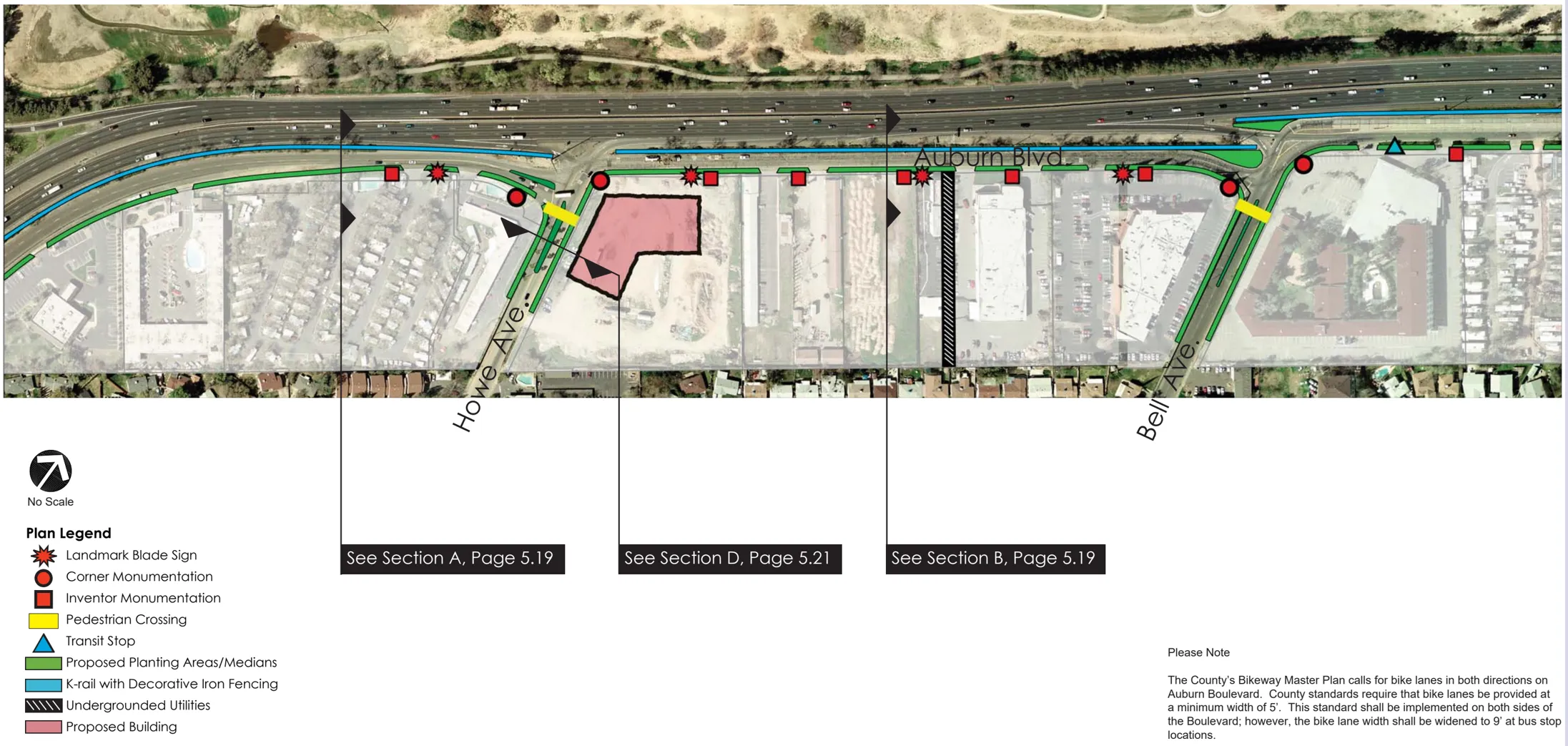
West Auburn Boulevard - Bell Avenue to Fulton Avenue
Section titled “West Auburn Boulevard - Bell Avenue to Fulton Avenue”- Re-stripe the Boulevard to allow for one 12’ vehicular lane in each direction and an 11’ center median/turn lane. Additionally, provide one 8’ bike lane on the south side and one 6’ lane along the north side of the street.
- Add medians where they will not interfere with intersecting traffic from private driveways per County requirements.
- Where medians are not possible, provide a center turn lane denoted with decorative imprinted asphalt.
- Provide a pedestrian crossing for north-south and east-west traffic at intersection of Fulton Avenue, linking the existing freeway overpass to the Boulevard.
- Add a detached sidewalk on the south side of the street, separated from the roadway by a planting area.
- Provide fi ve landmark blade signs, one corner monument and ten inventor monuments along the south side of the Boulevard as described earlier.
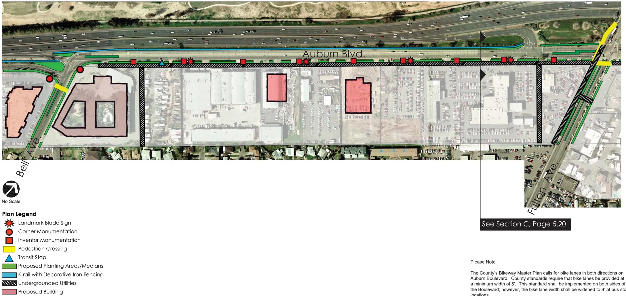
West Auburn Boulevard - Fulton Avenue to Morse Avenue
Section titled “West Auburn Boulevard - Fulton Avenue to Morse Avenue”- Add a traffic signal at the intersection of Morse Avenue and West Auburn Boulevard.
- Re-stripe the Boulevard to allow for one 12’ vehicular lane in each direction and an 11’ center median/turn lane. Additionally, provide one 8’ bike lane on the south side and one 6’ lane along the north side of the street.
- Add medians along the street where they will not interfere with intersecting traffic from private driveways (as shown on plans).
- Where medians are not possible, provide a center turn lane denoted with decorative imprinted asphalt.
- Provide a median on Morse Avenue extending south to within 50’ of the first driveway.
- Add a pedestrian crossing to West Auburn Boulevard at the intersection of Morse Avenue.
- Relocate the westbound and eastbound bus stops near Deseret Industries to just east of the intersection with Morse Avenue.
- Provide two bus shelters at the remaining existing locations.
- Add a detached sidewalk on the south side of the street, separated from the roadway by a planting area.
- Provide four landmark blade signs, one corner monument and nine inventor monuments along the south side of the Boulevard as described earlier.
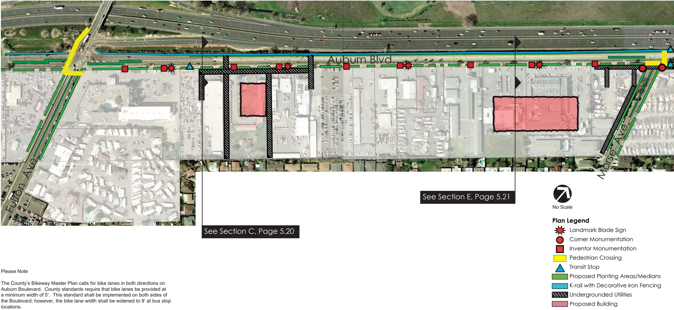
West Auburn Boulevard - Morse Avenue to Watt Avenue
Section titled “West Auburn Boulevard - Morse Avenue to Watt Avenue”- Re-stripe the Boulevard to allow for one 12’ vehicular lane in each direction and an 11’ center median/turn lane. Additionally, provide one 8’ bike lane on the south side and one 6’ lane along the north side of the street.
- As West Auburn Boulevard approaches Watt Avenue, additional through and dedicated turn lanes are required to accommodate existing traffic conditions. The second westbound through lane will be re-striped to become a dedicated on-ramp onto the Capital City Freeway. As such, the number of lanes between Watt Avenue and the western on/off ramps will be unchanged.
- Add medians along the street where they will not interfere with intersecting traffic from private driveways.
- Where medians are not possible, provide a center turn lane denoted with decorative imprinted asphalt.
- In addition to bus stops at the intersection of Morse Avenue, provide a bus shelter at the existing stop location just west of Watt Avenue.
- Add a detached sidewalk on the south side of the street, separated from the roadway by planting area.
- Provide four landmark blade signs, two corner monument and eight inventor monuments along the south side of the Boulevard as described earlier.
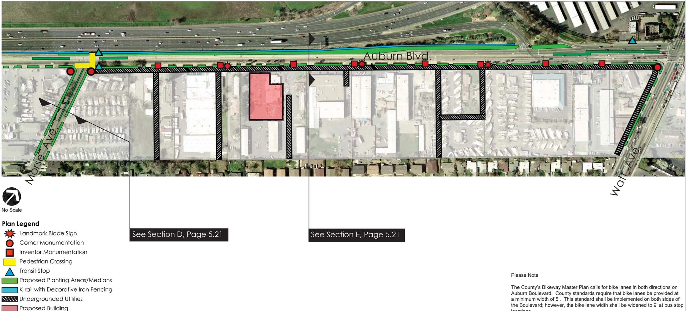
WEST AUBURN BOULEVARD MASTER PLAN SECTION / PLAN A & B
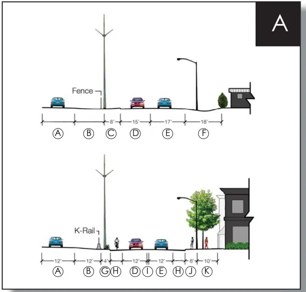
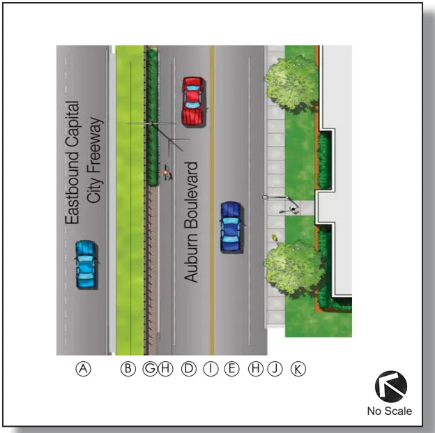
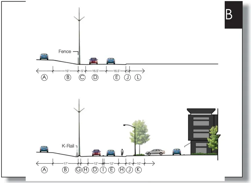
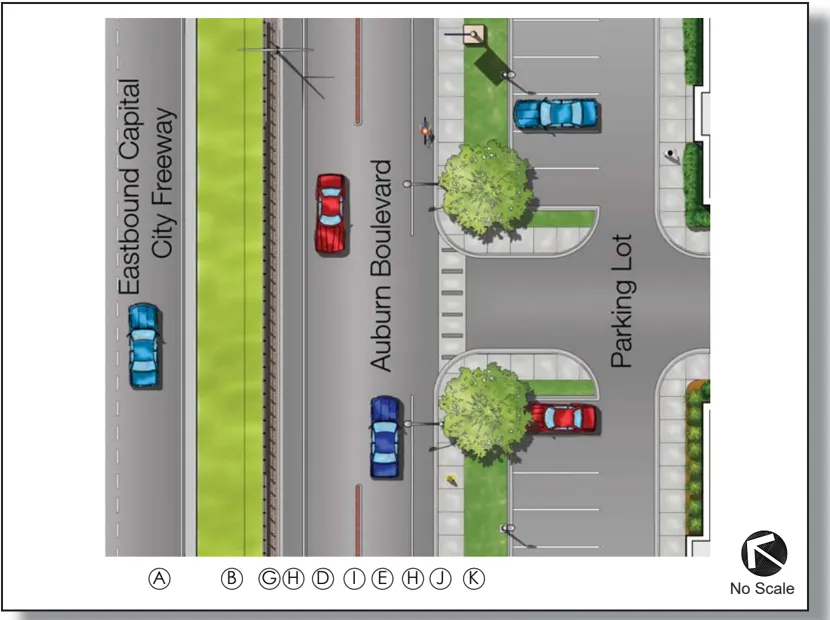
Legend for above graphics
- A Eastbound Capital City Freeway
- B Highway Shoulder
- C Unimproved Roadside Shoulder
- D Westbound Lane
- E Eastbound Lane
- F Unimproved Street & Landscape Setback
- G Curb, Gutter, & Enhanced Paving/ Landscaping
- H 5’ Wide Bike Lane (9’ at Bus Stops)
- I Double Yellow Line Divider
- J Sidewalk
- K Minimum Landscape Setback
- L Vacant Parcel
Please Note The County’s Bikeway Master Plan calls for bike lanes in both directions on Auburn Boulevard. County standards require that bike lanes be provided at a minimum width of 5’. This standard shall be implemented on both sides of the Boulevard; however, the bike lane width shall be widened to 9’ at bus stop locations.
WEST AUBURN BOULEVARD MASTER PLAN SECTION / PLAN C
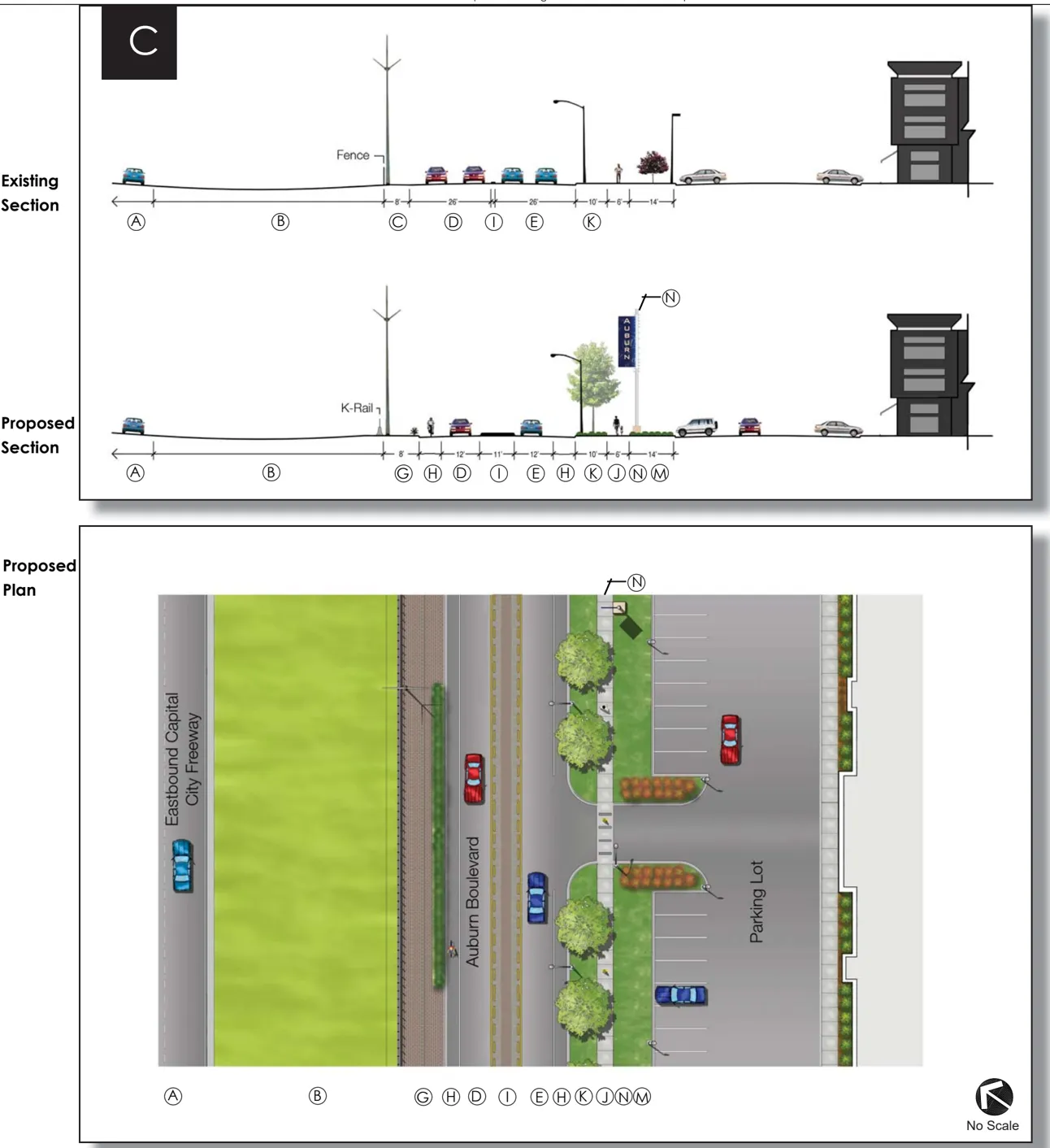
Legend for above graphics
- A Eastbound Capital City Freeway
- B Highway Shoulder
- C Unimproved Roadside Shoulder
- D Westbound Lane
- E Eastbound Lane
- F Unimproved Street & Landscape Setback
- G Curb, Gutter, & Enhanced Paving/ Landscaping
- H 5’ Wide Bike Lane (9’ at Bus Stops)
- I Double Yellow Line Divider
- J Sidewalk
- K Parkway Strip
- L Vacant Parcel
- M Minimum Landscape Setback
- N Pylon Sign in Expanded Right-ofway
Please Note The County’s Bikeway Master Plan calls for bike lanes in both directions on Auburn Boulevard. County standards require that bike lanes be provided at a minimum width of 5’. This standard shall be implemented on both sides of the Boulevard; however, the bike lane width shall be widened to 9’ at bus stop locations.
WEST AUBURN BOULEVARD MASTER PLAN SECTION / PLAN D & E
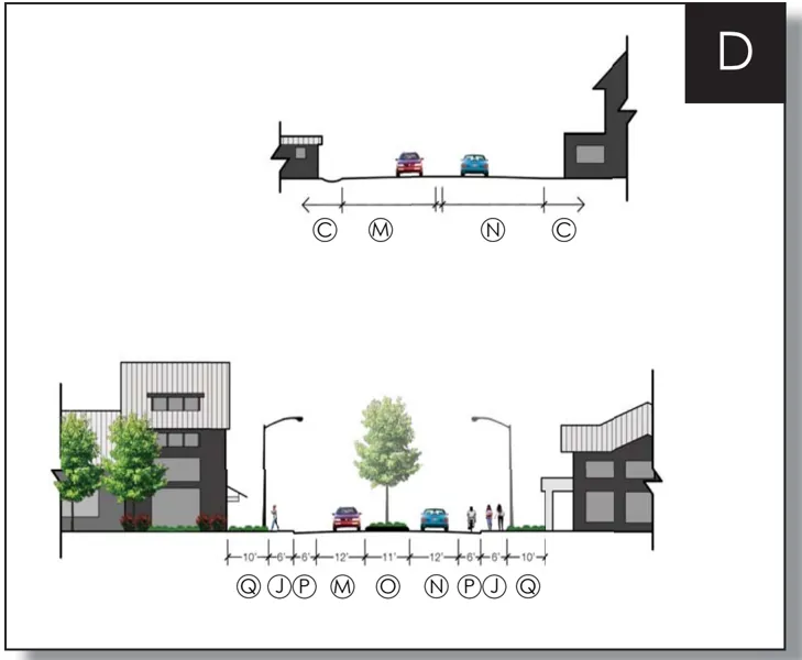
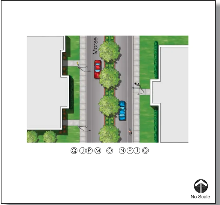
Proposed Plan
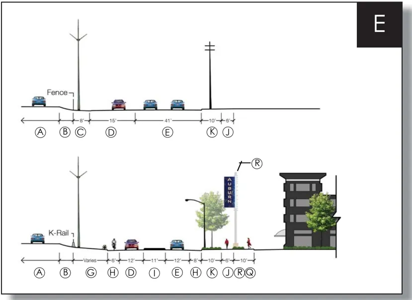
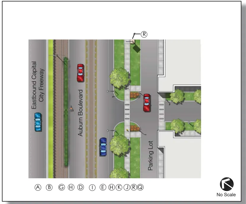
Proposed Plan
Legend for above graphics
- A Eastbound Capital City Freeway
- B Highway Shoulder
- C Unimproved Roadside Shoulder
- D Westbound Lane
- E Eastbound Lane
- F Unimproved Street & Landscape Setback
- G Curb, Gutter, & Enhanced Paving/ Landscaping
- H 5’ Wide Bike Lane (9’ at Bus Stops)
- I Double Yellow Line Divider
- J Sidewalk
- K Parkway Strip
- L Vacant Parcel
- M Northbound Lane
- N Southbound Lane
- O Proposed Median
- P Curb and Gutter
- Q Minimum Landscape Setback
- R Pylon Sign in Expanded Right-ofway
Please Note The County’s Bikeway Master Plan calls for bike lanes in both directions on Auburn Boulevard. County standards require that bike lanes be provided at a minimum width of 5’. This standard shall be implemented on both sides of the Boulevard; however, the bike lane width shall be widened to 9’ at bus stop locations.
E. Materials Palette
Section titled “E. Materials Palette”In keeping with the design approach described earlier, the Master Plan recommends a palette of furnishings and finishes that will complement the look of local businesses and create a uniform streetscape.
Furnishings
Section titled “Furnishings”-
Bench
- Make: Landscape Forms
- Model: Arcata Style, with aluminum slats
- Color: Frame - Silver, Slats - Titanium
- Comments: Embedded Mounting
-
Trash Receptacle
- Make: Landscape Forms
- Model: Chase Park Style with side opening
- Color: Titanium
-
Bike Rack
- Make: Landscape Forms
- Model: Bola Style
- Color: Stainless Steel
- Comments: Embedded Mounting
-
Tree Grate
- Make: South Bay Foundry
- Model: D11 Series
- Color: Un finished Weathered Cast Iron
-
Bus Shelter
- Make: Columbia Equipment
- Model: Ridgeford Park
- Color: To match metal finishes shown below
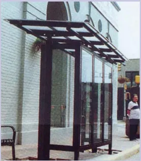
Bus stop shelters are oriented to face adjacent properties
Monumentation
Section titled “Monumentation”-
Landmark Blade Sign:
- Base: Pacific Clay Brick - Summer Glacier
- Pole: Fiberglass
- Blade: Vinyl Coated Aluminum
- Background Color: Sherwin Williams Loyal Blue (SW 6510)
- Commercial ‘At’ Symbol Color: Sherwin Williams Tradewind (SW 6218)
- Lettering Color: Sherwin Williams Welcome White (SW 6658)
-
Corner Monuments
- Signage:
- Manufacturer: Winsor Fireform
- Color: Sherwin Williams Loyal Blue (SW 6510)
- Monumnent
- Base: Pacific Clay Brick - Summer Glacier
- Midsection: Semi Smooth Stucco - Color: Sherwin Williams Welcome White (SW 6658)
- Top: Custom Aluminum
- Signage:
-
Inventor Monuments
- Signage:
- Manufacturer: Winsor Fireform
- Color: Sherwin Williams Loyal Blue (SW 6510)
- Monument:
- Base: Pacific Clay Brick - Summer Glacier
- Signage:

6510

6218

6992

6328

6658

6594

7100

Titanium

Silver

Stucco
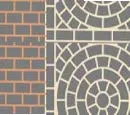
Streetprint

Summer Glacier

Sandstone Blend
Lighting
Section titled “Lighting”- Street Lighting:
- County Standard Cobra Head
- Color: Painted - Sherwin Williams - Loyal Blue (SW 6510)
Finishes
Section titled “Finishes”-
Color Palette
- Sherwin Williams - Loyal Blue (SW 6510)
- Sherwin Williams - Welcome White (SW 6658)
- Sherwin Williams - Tradewind (SW 6218)
- Sherwin Williams - Poinsettia (SW 6594)
- Sherwin Williams - Inkwell (SW 6992)
- Sherwin Williams - Arcade White (SW 7100)
- Sherwin Williams - Fireweed (SW 6328)
-
Metal Finishes
- Landscape Forms ‘Titanium’ (Metal-Polyester Powdercoat)
- Landscape Forms ‘Silver’ (Metal-Polyester Powdercoat)/ Stainless Steel
- Unfinished Weathered Cast Iron
-
Brick, Stucco and Hardscape Finishes
-
Imperfect-Smooth Stucco, Color: Sherwin Williams Welcome White (SW 6658)
-
Pacific Clay Brick: Western Ridge Summer Glacier
-
Concrete Pavers: Pavestone - Holland Stone, Sandstone Blend
-
Decorative Imprinted Asphalt: Duratherm Streetprint
- Brick Border Color: Sherwin Williams Fireweed (SW 6328)
- Customized Wagon Wheel: Sherwin Williams Arcade White (SW 7100)
- Solid Fill: Brick ‘caps’ per Duratherm streetprint in County Standard yellow striping color
-
Colored Concrete: LM Sco fi eld - Barcelona Brown (1017)
Plant Materials
Section titled “Plant Materials”- Trees
- Acer Rubrum- Red Maple
- Washingtonia fi lifera-California Fan Palm
- Shrubs
- Dietes vegeta - Fortnight Lily
- Rhaphiolepis indica- India Hawthorn
- Nassella Tenuissima- Mexican Feather Grass
- Phormium tenax - New Zealand Flax
- Ground Covers
- Juniperus horizontalis - Juniper
- Trachelospernum jasminoides - Star Jasmine
- Vinca minor - Periwinkle
- Other plant material may be accepted for use upon authorization by the County of Sacramento.
Red Maple

California Fan Palm

New Zealand Flax
Fortnight Lily
Juniper
Fortnight Lily
Star Jasmine

Mexican Feather Grass
Periwinkle
SECTION SIX: Implementation Plan
Section titled “SECTION SIX: Implementation Plan”Section Six evaluates the projected costs to implement the recommendations of the Streetscape Master Plan. An analysis of issues affecting these costs includes phasing considerations, regulatory policies, development standards, streetscape improvement policies, funding sources and administration of the Plan area.
A. Action Plan
Section titled “A. Action Plan”In order to fully implement the Plan, several action steps must be followed:
- Certify a Environmental Document
- Adopt the Land Use Plan and Development Standards;
- Adopt the Streetscape Master Plan;
- Implement an Streamlined Review Program;
- Seek funding for public improvements and establish either an LLD or PBID;
- Conduct a full sewer study to address all sanitary issues relating to this project to the standards and specifications of the Sacramento Area Sewer District. Also determine sewer needs for build out;
- Consult with property owners on ultimate raised median locations;
- Prepare Streetscape Improvement Plans;
- Identify opportunity sites for Revitalization.
B. Funding Sources
Section titled “B. Funding Sources”Creation of a long-term mechanism for continued maintenance and security along the Boulevard is critical to the successful implementation of the Streetscape Master Plan. Without proper maintenance, the bene fits provided by the streetscape improvements will be lost over time. Achieving an effective maintenance program can be accomplished either through the establishment of a Landscape and Lighting District and/or a Property-Based Business Improvement District.
Both funding sources are calculated on a linear front footage basis for each parcel. The linear front footage is the length of the property line adjacent to West Auburn Boulevard.
Landscape and Lighting District (LLD)
Section titled “Landscape and Lighting District (LLD)”An LLD is an instrument that provides funds for the regular maintenance and upkeep of landscape areas, funded by an assessment fee assigned to all properties receiving the benefit of the improvements. Funds collected from an LLD are used solely for the maintenance and replacement of items within the district.
Implementation of an LLD depends on a majority of property owners voting to participate in the program. Existing owner-occupied singlefamily residential uses within the Plan area will be exempted from the Landscape and Lighting District (LLD).
Property-Based Business Improvement District (PBID)
Section titled “Property-Based Business Improvement District (PBID)”Throughout the master planning process, a Property-Based Business Improvement District (PBID) was discussed with and encouraged by property owners. This Master Plan recommends the establishment of a PBID to provide consistent maintenance and security along the Boulevard in addition to supporting and identifying initial catalyst projects to further redevelopment along West Auburn Boulevard. Property owners must support and vote on acceptance of a PBID. This type of funding would provide property owners better control over the way their money is spent in that an elected Board of Directors oversees the PBID.
The completed Streetscape Improvement Plans will include details on the number and type of trees, plants, benches, streetlights, trash cans and other streetscape amenities so that an annual maintenance budget can be calculated. The annual maintenance budget will be divided by the total linear feet of West Auburn Boulevard within the Plan area. The resulting number will be the annual assessment per lineal front footage for each business.
C. Phasing Considerations
Section titled “C. Phasing Considerations”Phasing of large-scale projects is a requirement in today’s economy. Phasing of construction projects provides property owners and the County the ability to hand select projects which meet their collective goals. Projects may be realized earlier and therefore be more consistent with the goals of this Master Plan.
Stakeholders were routinely asked what priorities were given to the recommended improvements. Stakeholder priorities identified visibility along West Auburn Boulevard and to the Boulevard from the Capital City Freeway as a component of Phase I streetscape and utility improvement construction. Every effort should be made to include the landmark blade signs in Phase I construction.
A very close second priority is the requirement to clean up the Boulevard. The construction of the ‘K-rail’ separation between the freeway and the Boulevard, as well as the resulting curb, gutter and landscape improvements immediately adjacent to the ‘K-rail,’ would substantially realize this priority.
D. Projected Costs
Section titled “D. Projected Costs”In order to adequately address the phasing, funding and construction needs of a project a budget must be formulated for the proposed work. While this estimate has addressed all the elements outlined in the Streetscape Master Plan, it is impossible to identify all project requirements until engineered Streetscape Improvement Plans are produced.
The following is a budgeted estimate of construction costs based on the elements of the Streetscape Master Plan. This estimate is based on 2006 dollars and should be updated as Streetscape Improvement Plans are produced.
West Auburn Boulevard Streetscape Master Plan Preliminary Budget Estimate
Section titled “West Auburn Boulevard Streetscape Master Plan Preliminary Budget Estimate”September 20,2006
Infrastructure
Section titled “Infrastructure”| Infrastructure | Dollars |
|---|---|
| Right-of-Way Acquisitiion | 300,000 |
| Mobilization | 850,000 |
| Construction Staking | 75,000 |
| SWPPP/Pollution Control | 80,000 |
| Clearing and Grubbing | 50,000 |
| Traffic Control | 100,000 |
| Relocate BusStop | 5,000 |
| Undergrounding Utilities (Roadway) | 2,022,500 |
| Undergrounding Utilities (Site) | 1,280,000 |
| Roadway Excavation | 200,000 |
| Sidewalk/Driveway (Repairs) | 182,500 |
| ADA Ramp | 60,000 |
| Sidewalk/Driveway | 73,500 |
| Vertical Curb & Gutter - North Side of Street | 437,500 |
| Vertical Curb & Gutter - Median | 513,500 |
| Vertical Curb & Gutter - South Side | 153,500 |
| Vertical Curb & Gutter - Side Streets / Repairs | 109,500 |
| Storm Drain Additions | 2,200,000 |
| Signalization | 250,000 |
| Electrical Service | 75,000 |
| Water Service | 150,000 |
| Infrastructure Subtotal | $9,167,500 |
Surfacing & Finishes
Section titled “Surfacing & Finishes”| Surfacing & Finishes | Dollars |
|---|---|
| Enhanced Median Turn Lane | 1,059,500 |
| Median Maintenance Border | 23,000 |
| Enhanced Paving at K-rail | 995,500 |
| Cold Plane AC Pavement | 782,000 |
| AC Overlay | 1,173,000 |
| Striping | 122,000 |
| Crosswalk | 13,000 |
| Surfacing & Finishes Subtotal | $4,168,000 |
Signage & Lighting
Section titled “Signage & Lighting”| Signage & Lighting | Dollars |
|---|---|
| Miscellaneous Signage | 50,000 |
| Painted Street Lights/traffic Signals | 915,500 |
| Landmark Blade Sign with Lighting | 750,000 |
| Corner Monument | 59,500 |
| Inventor Monument | 256,000 |
| Miscellaneous Painting | 50,000 |
| Signage & Lighting Subtotal | $2,081,000 |
Furnishings & Fencing
Section titled “Furnishings & Fencing”| Furnishings & Fencing | Dollars |
|---|---|
| Decorative Fencing | 1,039,500 |
| K-Rail | 2,188,000 |
| Benches | 31,000 |
| Bike Racks | 26,500 |
| Bollards | 35,000 |
| Tree Grates | 60,000 |
| Trash Receptacles | 15,000 |
| Bus Shelter / Stop | 30,000 |
| Furnishings & Fencing Subtotal | $3,425,000 |
Landscaping
Section titled “Landscaping”| Landscaping | Dollars |
|---|---|
| Shrubs & Groundcover | 2,855,500 |
| Trees | 224,500 |
| Pruning of Existing Trees | 25,000 |
| Topsoil Back fi ll | 740,500 |
| Finish Grading | 71,500 |
| Soil Amendments | 28,500 |
| Bark Mulch | 198,500 |
| 48 Station Irrigation Controller | 50,000 |
| Water Meters and Back flow Devices | 30,000 |
| Irrigation | 571,000 |
| Landscape Maintenance Period (120 Days) | 50,000 |
| Landscaping Subtotal | $4,845,000 |
Project Subtotal $23,686,500
| Additional Costs | Dollars |
|---|---|
| Improvement Plans (10%) | 2,368,500 |
| Administration & Project Management (15%) | 3,553,000 |
| Inspection (3%) | 710,500 |
| Permits & Fees (2%) | 473,500 |
| Contingencies (20%) | 4,737,500 |
Project Grand Total $35,529,500
SECTION SEVEN: Future Considerations
Section titled “SECTION SEVEN: Future Considerations”Section Seven identifies several planning issues that require further consideration by the jurisdictions and agencies that regulate West Auburn Boulevard. The ultimate success of the West Auburn Boulevard Streetscape Master Plan and Special Planning Area Ordinance depends on the resolution of these issues.
During the master planning process, several issues emerged which can only be addressed in conceptual terms at this time. However, these issues are critical to the ultimate success of the West Auburn Boulevard Streetscape Master Plan and Special Planning Area Ordinance and should be addressed by the County of Sacramento, the California Department of Transportation (Caltrans) and other involved agencies as quickly as possible.
A. Capital City Freeway Right-of-Way Landscaping
Section titled “A. Capital City Freeway Right-of-Way Landscaping”The California Department of Transportation has developed landscape plans for the Capital City Freeway which immediately abuts West Auburn Boulevard. Implementation of these plans was not funded and therefore will not proceed to construction at this time. The plans include removal of select trees within the Caltrans right-of-way, pruning of existing trees, and shoulder plantings within the right-of-way. As the plans currently stand, the plantings are not consistent with the goals of this Streetscape Master Plan. Any future project with Caltrans should be scrutinized closely to ensure that the plantings are consistent with the Master Plan, visibility to the Plan area and enhancement goals within the Plan area.
The improvements planned by Caltrans are crucial to the success of this Streetscape Master Plan, since the primary perception of West Auburn Boulevard occurs initially with the view from the freeway. Constituents who participated in the creation of this Master Plan remarked consistently that, without an active Caltrans project to improve its right-of-way, little work on the County’s part would be worthwhile.
Caltrans, as part of the Technical Advisory Committee, is aware of these concerns and every effort should be made for the County and Caltrans to work together to seek funding for this project.
B. Howe Avenue/ Bell Street Ramp Closure or Reconstruction
Section titled “B. Howe Avenue/ Bell Street Ramp Closure or Reconstruction”Two ‘hook ramps’ currently exist within the Plan area at Howe Avenue and Bell Street. These ramps place a significant impact on West Auburn Boulevard. Their alignment makes vehicular, pedestrian and bicycle traffic awkward and causes the western half of the Plan area to be under-used. In addition, knowledgeable freeway travelers often use these ramps as a bypass during peak freeway travel times. The County has researched the impacts of these ramps several times over the years and has approached Caltrans with their fi ndings. However, Caltrans has no plans currently to close or improve either the Bell or Howe Avenue on/off ramps. This Plan recommends that the ramps be realigned to improve the connection to West Auburn Boulevard and improve conditions for pedestrians and bicyclists. Should improvements proceed, the alignment of West Auburn Boulevard should be examined to encourage better traffic movement in the Plan area.
C. Fulton Avenue Overpass
Section titled “C. Fulton Avenue Overpass”The County, City of Sacramento and Caltrans recognize that the overpass at Fulton Avenue is presently substandard, although reconstruction of this overpass is not contemplated in the near term. This Master Plan considers the reconstruction of this overpass to current standards to be paramount to the success of the Plan area. The Fulton Avenue overpass is the only connection between the north side of the freeway and Haggin Oaks Golf Course and the Plan area. This link is vital to the economic future of the Boulevard and must be upgraded. Considerations in reconstruction should be addressed as follows:
- Ensure pedestrian safety and access on both sides of the overpass;
- Carefully examine the number of lanes and lane widths (particularly if ramp closures are eminent or have already occurred) with respect to traffic volumes;
- Respect existing landscape features (particularly the Fulton Avenue landmark element) in any redesign of on/off ramp reconstruction.
D. Consider Bike Lane Location Options
Section titled “D. Consider Bike Lane Location Options”During the public workshops, stakeholders advocated against the placement of bike lanes along West Auburn Boulevard due to safety and maneuverability considerations. This requirement, however, is mandated by the County’s Bikeway Master Plan and can be removed only by an act of the Board of Supervisors. This Master Plan recommends that flexibility along the Boulevard be fully recognized and the placement of bike lanes proceed. The bike lanes will allow for greater vehicular maneuverability within the Plan area.
E. Parcel Consolidation, Shared Driveways and Reciprocal Parking
Section titled “E. Parcel Consolidation, Shared Driveways and Reciprocal Parking”The SPAO intends to encourage parcel consolidation, reciprocal parking and/or shared driveways. However, the present condition of the Boulevard and its adjacent parcels does not provide for this improvement, except in rare circumstances. As parcels are consolidated and driveway easements and reciprocal parking agreements are adopted, the County should research the ability to place additional raised and planted medians, consistent with this Master Plan, to further accentuate the value of the Boulevard.
Appendices
Section titled “Appendices”Review the West Auburn Boulevard SPA Appendices. This is an archived PDF document.