Fair Oaks Boulevard Main Street SPA
Sacramento County Zoning Code
Fair Oaks Boulevard Main Street District Special Planning Area Ordinance
Section titled “Sacramento County Zoning Code Fair Oaks Boulevard Main Street District Special Planning Area Ordinance”Adopted October 26, 2011
Amended November 7, 2023 & June 11, 2026
Adopted by ZMA #5624 / PLNP2008-00142
Amended by PLNP2023-00105 & PLNP2024-00194
Sacramento County & Carmichael Community
Prepared by Sacramento County Planning Department
With assistance by RACESTUDIO & A. Plescia Company
Main Street District SPA Development Standards
Section titled “Main Street District SPA Development Standards”The Development Standards for the Main Street District of the Corridor Plan implement popular concepts and principles. The standards are a hybrid approach incorporating “form-based” and traditional zoning features. They provide for greater flexibility in terms of parking and land use. The standards are also more prescriptive in terms of the physical form and siting of buildings.
The following ordinance provides the quantitative criteria for new investment in the Main Street District, as identified by the Fair Oaks Boulevard (FOB) Corridor Plan. It includes a new set of development standards unique to the District.
Introduction
Section titled “Introduction”This Special Planning Area (SPA) ordinance will govern properties located in the Main Street District area. The SPA includes a special set of planning policies and development standards unique to these areas.
The following presents the FOB Corridor Plan’s development standards for land use (i.e., uses, building heights and setbacks) and circulation (e.g., roadway improvements). This section builds upon the concepts, goals, and principles found in the FOB Corridor Plan and provides the detailed quantified standards essential for implementation of the broader vision of the Corridor Plan.
Development Standards
Section titled “Development Standards”The development standards in this ordinance provide quantitative direction for public and private investment in the Main Street District area. They are measurable and are meant to establish maximum and minimum requirements.
- Main Street District Land Use
- Main Street District Development Standards
- Standards for Signs
- Review Process
- Potential for Added Development
- Non-Conforming Uses
- Uses Not Provided for in the Land Use Table
Purpose of Development Standards
Section titled “Purpose of Development Standards”The Plan works in combination with the Zoning Code to specify development standards for the Main Street District of the Fair Oaks Boulevard Corridor.
Main Street District Land Use
Section titled “Main Street District Land Use”The standards described in this Plan are intended to reinforce concepts and principles outlined in the FOB Corridor Plan. They identify land use designations, permitted uses and ground floor land use requirements for the Main Street District.
The FOB Corridor Plan provides a flexible and more generalized approach to land uses than the County’s Zoning Ordinance. It is intended to provide for new buildings that can accommodate a variety of uses as the Corridor evolves. Uses permitted in each of these districts support overall community objectives for the Corridor area.
Permitted Land Use
Section titled “Permitted Land Use”The Main Street District has variations in allowable uses that were identified by the community in the planning process. Table 1 identifies permitted uses and the type of permit process required.
- Permitted Use (P) – Permitted uses are allowed by right without the need for discretionary review by the Planning Director, Planning Commission, or Board of Supervisors. Some of the permitted uses include Use Standards that provide limitations on operations.
- Conditionally Permitted Use (C) – Uses marked with a (C) are conditionally permitted uses that are allowed with a conditional use permit by the Planning Commission or Board of Supervisors, as specified, after a recommendation by the Carmichael - Old Foothill Farms Community Planning Advisory Council (CPAC).
- Not Permitted (–) Uses marked with (–) are not allowed under any conditions.
Required Ground Floor Commercial
Section titled “Required Ground Floor Commercial”In order to support the desired design, economic and social objectives for the Boulevard, the land use standards require ground floor commercial uses along designated street front- ages in the Main Street District area. The following diagrams provide examples of potential development patterns for the locations that require storefront ground floor commercial uses adjacent to the sidewalk. The specific street segments subject to ground floor commercial are identified in the diagram on Page 1 of the Fair Oaks Boulevard Air Quality Mitigation Plan (Appendix 2). The design guidelines in Section Four of the FOB Corridor Plan provide the qualitative requirements for these pedestrian-oriented building edges.
Non-Conforming Uses
Section titled “Non-Conforming Uses”Single-family residential uses:
Section titled “Single-family residential uses:”- Single-family residential uses that were established legally prior to the adoption of the SPA in October 2011 may continue indefinitely and may be maintained, remodeled or expanded so long as they meet the development standards of Zoning Code Section 5.4.2.C.
- Properties developed with a non-conforming single- family residence may add residential accessory structures and/or accessory dwelling units so long as they meet the standards of Zoning Code Section 5.4.5.
- Properties developed with a non-conforming single- family residence are permitted to include accessory uses as provided in Zoning Code Table 3.2 that are applicable to residential RD-5.
All other non-conforming uses and buildings:
Section titled “All other non-conforming uses and buildings:”- Non-conforming uses in an existing building (Use/ business previously permitted by right) requires a conditional use permit or is prohibited in Corridor Plan. The use/business can continue to operate indefinitely, or the same type of use/business may reoccupy the premises, as long as the vacancy period and/or lapse of business license (if required for use) does not exceed 12 months for properties located in the Main Street District. Extensions of the vacancy period may be approved by the Planning Commission.
- Remodel of a Non-conforming building (including major and minor remodels): A building non- conforming as to setbacks, height, and other development and design standards. Note: in most cases, the Corridor Plan provides more flixibility in Development standards and few buildings become non-conforming under the Plan.
Demolition of any non-conforming building:
Section titled “Demolition of any non-conforming building:”- New construction on vacant or demolished sites shall conform to the development and design standards in the Corridor Plan, per the Project Review Process described in this section.
Uses not Provided for in the Land Use Table
Section titled “Uses not Provided for in the Land Use Table”If a use is not listed in Table 1: Allowable Uses as permitted or conditionally permitted, the use is prohibited, unless the Planning Director determines that either:
- The use is substantially similar in characteristics, intensity, and compatibility to a use or uses listed in Table 1; or
- The use would be appropriate in the Main Street District, applicable to the specific property as a permitted or conditional use. The Planning Director shall make findings that the use is consistent with the overall intent of the SPA and any applicable provisions of the FOB Corridor Plan and adopted Mitigation Measures. Typical examples include determinations for allowable accessory uses related to a permitted or conditionally permitted use and/or instances where there may be an inconsistency or lack of specificity within the SPA or related documents.
In those cases where the Planning Director determines that the use meets criteria listed above, the use shall conform to all the regulations in this SPA that are applicable to the similar described use(s). If the use would be appropriate in the Main Street District as a conditional use, a Conditional Use Permit shall be heard by the designated hearing body for the similar use.
Map of Fair Oaks Boulevard Special Planning Area
Section titled “Map of Fair Oaks Boulevard Special Planning Area”
Table 1: Allowable Uses
Section titled “Table 1: Allowable Uses”[AMENDED 06-11-2026]
| Land Use | Type | Main Street District | Use Standards Footnotes |
|---|---|---|---|
| Accessory retail uses | Retail Trade Uses | P | |
| Liquor Store | Retail Trade Uses | C | (14) |
| Artisan shop | Retail Trade Uses | P | |
| Auto sales | Retail Trade Uses | -- | |
| Auto parts sales with no installation services | Retail Trade Uses | -- | |
| Auto Rental | Retail Trade Uses | -- | |
| Building/landscape materials sales | Retail Trade Uses | -- | |
| Construction and heavy equip. sales & rental | Retail Trade Uses | -- | |
| Convenience store | Retail Trade Uses | P | (1) |
| Drive-through retail | Retail Trade Uses | C | (3)(9)(12) |
| Drug store, pharmacy | Retail Trade Uses | P | |
| Firearm sales, gunsmith | Retail Trade Uses | -- | |
| Fuel dealer (propane, etc.) | Retail Trade Uses | -- | |
| Furniture, furnishings and appliance store | Retail Trade Uses | P | |
| General retail less than 50,000 sq feet (including outdoor and nursery space) | Retail Trade Uses | P | |
| General retail more than 50,000 sq feet (including outdoor and nursery space) | Retail Trade Uses | C | |
| Groceries, specialty foods, less than 50,000 sq ft | Retail Trade Uses | P | |
| Groceries, specialty foods, more than 50,000 sq ft | Retail Trade Uses | C | |
| Mobile home, boat, or RV sales | Retail Trade Uses | -- | |
| Motorcycle Sales | Retail Trade Uses | -- | |
| Office-supporting retail | Retail Trade Uses | P | |
| Pawn Shop | Retail Trade Uses | -- | |
| Restaurant, café, coffee shop | Retail Trade Uses | P | |
| Retail complex | Retail Trade Uses | P | |
| Service station | Retail Trade Uses | -- | |
| Vending machines, outdoors | Retail Trade Uses | -- | |
| Antiques Store | Retail Trade Uses | P | |
| Tobacco Store/Smoke Shop | Retail Trade Uses | C | |
| ATM | Services – Business, Financial & Professional | P | |
| Business, financial services | Services – Business, Financial & Professional | P | |
| Business support service | Services – Business, Financial & Professional | P | |
| Check Cashing | Services – Business, Financial & Professional | -- | |
| Hospital and Medical services – MD office, clinic, urgent care | Services – Business, Financial & Professional | P | |
| Medical services – Laboratory | Services – Business, Financial & Professional | C | |
| Office, including Call Centers | Services – Business, Financial & Professional | P | |
| Retail Print Shop | Services – Business, Financial & Professional | P | |
| Billboards | Services – Business, Financial & Professional | -- | |
| Adult day care | Services – General | C | |
| Bakery, incidental gourmet food production | Services – General | P | |
| Catering service | Services – General | P | (2)(12) |
| Car Wash | Services – General | C | (3)(12)(15) |
| Child day care center | Services – General | C | |
| Drive-through service | Services – General | C | (3)(9)(12) |
| Equipment rental | Services – General | -- | |
| Kennel, animal boarding | Services – General | -- | (13) |
| Lodging – Bed & breakfast inn (B&B) | Services – General | P | |
| Lodging – Hotel or motel | Services – General | P | |
| Massage Therapy | Services – General | -- | |
| Mortuary, funeral home/Crematory | Services – General | -- | |
| Personal services | Services – General | P | |
| Public facilities | Services – General | P | (12) |
| Repair service – Equip., large appliances, etc (non-Automobile) | Services – General | -- | |
| Tanning Salons | Services – General | -- | |
| Tattoo Parlors | Services – General | -- | |
| Vehicle services – Major repair/body work | Services – General | -- | |
| Vehicle services – Minor maintenance/repair | Services – General | -- | |
| Veterinary clinic, animal hospital | Services – General | C | (1) |
| Artisan/craft product manufacturing | Industry, Manufacturing, Processing | C | (1) |
| Construction contractor base | Industry, Manufacturing, Processing | -- | |
| Food & beverage product manufacturing | Industry, Manufacturing, Processing | C | |
| Furniture & fixtures manufac., cabinet shop (with showroom) | Industry, Manufacturing, Processing | -- | |
| Industrial research and development | Industry, Manufacturing, Processing | C | (1)(2) |
| Laboratory – Analytical, testing | Industry, Manufacturing, Processing | C | (1)(2) |
| Media production | Industry, Manufacturing, Processing | P | |
| Mini-Storage | Industry, Manufacturing, Processing | -- | |
| Production Commercial Printing | Industry, Manufacturing, Processing | -- | |
| Recycling – Small collection facility | Industry, Manufacturing, Processing | -- | |
| Bar/tavern brew pub | Recreation, Education and Public Assembly Uses | P | (5) |
| Commercial rec. facility – Indoor | Recreation, Education and Public Assembly Uses | P | (5) |
| Commercial rec. facility – Outdoor | Recreation, Education and Public Assembly Uses | -- | |
| Fitness/health facility | Recreation, Education and Public Assembly Uses | P | |
| Library, museum | Recreation, Education and Public Assembly Uses | P | |
| Meeting Hall, Social Center, public or private; Place of Worship | Recreation, Education and Public Assembly Uses | P | (5) |
| Night club | Recreation, Education and Public Assembly Uses | C | (7) |
| Park, playground | Recreation, Education and Public Assembly Uses | P | |
| School – College, university | Recreation, Education and Public Assembly Uses | P | (12) |
| School – Elementary, middle, secondary | Recreation, Education and Public Assembly Uses | P | |
| School – Specialized education/training | Recreation, Education and Public Assembly Uses | C | (1) |
| Studio – Art, dance, music, etc. | Recreation, Education and Public Assembly Uses | P | |
| Theater | Recreation, Education and Public Assembly Uses | P | (5) |
| Broadcasting studio | Transportation, Communications and Infrastructure | C | |
| Parking facility, public or comm., surface | Transportation, Communications and Infrastructure | P | (12) |
| Parking facility, public or comm., structured | Transportation, Communications and Infrastructure | P | (12) |
| Pipeline, utility transmission or distribution line | Transportation, Communications and Infrastructure | P | |
| Wireless Facility | Transportation, Communications and Infrastructure | C | (10) |
| Transit station | Transportation, Communications and Infrastructure | P | (1) |
| Terminal | Transportation, Communications and Infrastructure | C | (2) |
| Public Utility and Public Services Facility | Transportation, Communications and Infrastructure | P | (11) |
| Home occupation | Residential | P | |
| Live/work unit | Residential | P | |
| Residential component of mixed use project | Residential | P | (4)(6)(8) |
| Multi-family housing in a mixed- use structure | Residential | P | (4)(6)(8) |
| Multi-family housing (stand alone) | Residential | P | (4)(6)(8) |
| Congregate Care Facilities | Residential | P | |
| Social Rehabilitation Facilities | Residential | C |
Use Standard Footnotes for Table 1
Section titled “Use Standard Footnotes for Table 1”- Operation shall not be permitted between the hours of 10PM and 7AM. Extended hours may be permitted with a Conditional Use Permit.
- Permitted if the entire operation is conducted within a completely enclosed building or screened from view behind a fence or wall as set forth in Section 5.2.5. of the Zoning Code.
- Permitted subject to issuance of conditional use permit by the Board of Supervisors upon recommendation of the Planning Commission.
- To comply with General Plan Noise Element standards of 65 Db Ldn or less for residential/transient lodging outdoor activity areas and 45 Db Ldn or less for residential/transient lodging interiors. An acoustical analysis, prepared by a qualified acoustical consultant and verified by the Department of Environmental Review and Assessment, substantiating that the Interior noise level does not exceed 45 Db Ldn shall be provided.
- Hours of operation shall not be permitted between the hours of 12AM and 10AM unless extended with a Conditional Use Permit.
- When it is determined that the project does not meet the required Code development standards, the applicant may make application for a Special Development Permit for an alternative design, to be heard by the appropriate authority. It is recognized that there are many design alternatives to the standards contained herein that create a quality and compatible project.
- Permitted subject to issuance of a conditional use permit by the appropriate authority and provided a valid dancing license is obtained.
- Thresholds for the level of review are in Fair Oaks Boulevard SPA Project Review Process.
- Permitted per the requirements of Section 3.9.3.V. of the Zoning Code relating to drive through windows.
- Refer to Section 3.6.7. of the Zoning Code, using Group II standards.
- Permitted subject to the provision of Section 3.6.6. of the Zoning Code.
- Permitted, provided that all outdoor activities are not oriented toward Fair Oaks Boulevard.
- Cat boarding is permitted by right if the facility is located greater than 300 feet from residential zoned property. If the facility is located within 300 feet of residential zoning, a Conditional Use Permit will be required.
- Permitted as an accessory use.
- Permitted per the requirements of Section 3.7.9.I. of the Zoning Code relating to automobile wash facilities
Main Street District Development Standards
Section titled “Main Street District Development Standards”The physical form of the Main Street District is to reflect land use, social, and image criteria established by the Corridor Plan. The setbacks and heights identified in Table 2 include “allowable” and “required” standards. The “allowable standards” specify maximum amounts. For example, office buildings may be allowed to be up to three stories tall and commercial mixed use buildings up to four stories tall. Section Four of the FOB Corridor Plan provides Design Concepts that are intended to supplement the Countywide Design Guidelines. The County’s requirements for water quality, transit accessibility and other technical requirements would still apply.
Allowable Heights
Section titled “Allowable Heights”Allowable building heights for the Main Street District will reflect its economic function and community context. The Main Street District is a primary economic and social center of Carmichael. Therefore, it has a four-story allowable height for mixed-use developments.
Allowable and Required Densities
Section titled “Allowable and Required Densities”The Main Street District of the Corridor Plan includes both minimum and maximum densities for commercial, residential, and mixed-use development. The Main Street District has more intensive densities and mixed-use requirements than other areas within the FOB Corridor Plan to support economic and social objectives identified by the community.
Residential densities assume townhouse and stacked flat (units developed over other units) type projects that support transit and fit in a mixed use setting. Townhouses are developed from 20 to 30 dwelling units per acre and stacked flats in apartments or mixed-use buildings from 30 to 50 dwelling units per acre. To create a more pedestrian- intensive environment, minimum commercial densities are about 20% (Floor-Area-Ratio of 0.30 to 0.40) to 40% higher than typical strip development (0.25 FAR).
Required Setbacks
Section titled “Required Setbacks”Where possible, building setbacks are intended to establish a consistent walking edge along Fair Oaks Boulevard and connecting side streets, especially in the Main Street District. The setbacks are established from the back of curb locations based on street section standards identified in this section.
The sidewalk, planter strip, and building setback will provide a combined dimension of at least 16 feet from the back of curb to a storefront. Residential projects are to be set back farther from the road for sound and privacy reasons.
Transition between new development and existing residential uses requires setbacks and height standards that protect the visual and audio privacy of residents.
Parking Requirements
Section titled “Parking Requirements”The FOB Corridor Plan and SPA provide increased flexibility in meeting parking standards, and in some cases, reduces parking requirements where pedestrian and transit access is of primary importance. It also allows off-site shared parking on adjacent parcels within 300 feet to meet parking requirements. Because the Corridor Plan assumes a long- term planning horizon, the parking standards will mature with the land uses. The standards will require periodic monitoring and adjustments as the Boulevard transforms into a mixed mode corridor.
Examples of Potential Development Patterns
Section titled “Examples of Potential Development Patterns”
Table 2: Development Standards
Section titled “Table 2: Development Standards”| Land Use Designations | Maximum Height | Density | Transition to Single Family Residential |
|---|
| Required Setbacks | Boulevard Frontage | Side Street Frontage | Rear at Residential |
|---|
| Parking Requirements | Total Minimum Required | On-site Minimum | Off-Site / Shared Maximum |
|---|
Signage
Section titled “Signage”Main Street District has signage standards that reflect desired land use and urban design concepts. The Signage Standards identify basic objectives and dimensions for district, site, building and tenant signs. Variables include the size of the building, facade length and the type, and number of tenants. Besides the quantitative development standards in Table 2, the design guidelines in Section Four of the FOB Corridor Plan provides overall qualitative direction for signage in the Main Street District.
Table 3: Sign Standards
Section titled “Table 3: Sign Standards”| Site Signage | Building Signage | Tenant Signage |
|---|---|---|
| Monument signs are permitted at a maximum height of 6 feet and 24 square feet in area. | AREA: 1 SF per 1 LF of building, appear on one side | One window sign 4 SF max. One blade sign 4 SF max. |
Review Process
Section titled “Review Process”Project Review Process
Section titled “Project Review Process”Table 1 of the SPA outlines uses within the Main Street District that are allowable, conditionally allowable, or not allowed. Those uses that are conditionally allowable are subject to discretionary review by the County Planning
Commission or Board of Supervisors, as specified. Projects that are listed as allowable uses in the Land Use Table are subject to staff level (non-discretionary) development plan approval with review by the Design Review Administrator to ensure compliance with the criteria and standards set forth in the SPA, and Section Four of the FOB Corridor Plan, with the following exceptions:
-
When the Design Review Administrator determines that a project does not meet the criteria set forth in the SPA and Section Four of the FOB Corridor Plan, the project proponent shall make an application for a Special Development Permit subject to discretionary review by the County Planning Commission after review by the Carmichael-Old Foothill Farms CPAC.
-
Projects that include the following components shall require an application for Development Plan Review to be heard by the County Planning Commission after review by the Carmichael-Old Foothill Farms CPAC. The intent of this review is to provide for public review of design and site plan features. The intent is not to trigger additional environmental review with the assumption that the use and intensity of the project is covered under the EIR for the SPA.
- Any residential projects over 24 units per acre or 2 stories in height for any of the districts.
- Any High Density Residential Project in any area of the SPA over 45 units per acre is subject to a Conditional Use Permit.
-
Appeals Any person that is dissatisfied with an act or determination of the Planning Commission, Zoning Administrator, Chief Building Inspector, Planning Director, or the Secretary of the Planning Commission, may appeal such act or determination subject to Section 6.1.3. in the Sacramento County Zoning Code.
Example CMU
Section titled “Example CMU”
Development Standards Table
Section titled “Development Standards Table”Signage
Section titled “Signage”
CEQA MITIGATION MEASURES ADOPTED FOR FAIR OAKS BOULEVARD CORRIDOR PLAN
Section titled “CEQA MITIGATION MEASURES ADOPTED FOR FAIR OAKS BOULEVARD CORRIDOR PLAN”LA-1: Development Consistent With LU-34
Section titled “LA-1: Development Consistent With LU-34”The development standards in the Fair Oaks Boulevard Corridor Plan shall be modified to require future development and redevelopment in the project area to be consistent with LU-34 of the Sacramento County General Plan.
LA-2: Carmichael Colony Neighborhood Preservation Area
Section titled “LA-2: Carmichael Colony Neighborhood Preservation Area”The Carmichael Colony NPA guidelines shall be incorporated into the Fair Oaks Boulevard SPA to govern development on the properties which are included in both the NPA and SPA areas in order to avoid potentially significant land use conflicts. Development on these parcels shall be constant with the intent of the Carmichael Colony Neighborhood Preservation Area.
LA-3: Winding Way-Hackberry Lane Special Planning Area
Section titled “LA-3: Winding Way-Hackberry Lane Special Planning Area”The Winding Way- Hackberry Lane SPA guidelines shall be incorporated into the Fair Oaks Boulevard SPA to govern development on the properties which are included in both of the SPA areas in order to avoid potentially significant land use conflicts. Development on these parcels shall be constant with the intent of the Winding Way-Hackberry Lane Special Planning Area.
TC-1: 1-12
Section titled “TC-1: 1-12”Prior to Development Plan Review or issuance of building permits for projects resulting in intensification of use or increased square footage associated with development pursuant to the Fair Oaks Boulevard Special Planning Area Ordinance, the Sacramento County Municipal Services Agency (MSA) shall prepare, or facilitate the preparation of, a phasing plan that identifies thresholds of development for when necessary improvements are required. The phasing plan shall also identify a mechanism to track when thresholds are met so infrastructure improvements are constructed when needed.
If private applicants/developers wish to proceed with development ahead of MSA’s phasing plan, project specific analyses (i.e. sewer study, water study, traffic study) will be required to ensure that the existing infrastructure can accommodate the proposed development. Infrastructure improvements that are needed to accommodate proposed development shall be constructed prior to issuing building permits.
The following improvements shall be installed:
- Widen Cypress Avenue from Garfield Avenue to Manzanita Avenue to from two lanes to four lanes.
- Signalize the intersection of College Oak Drive and Winding Way. The signalization shall include setting the east-west approaches to split phasing, setting the north-south approaches to protected phasing, prohibiting westbound-to-eastbound U-turns, and allowing overlap phasing on the northbound-to-eastbound right-turn movement.
- At the Walnut Avenue and Winding Way Intersection split the westbound combined through/left-turn lane into an exclusive westbound-to southbound left-turn lane and an exclusive westbound through lane and set the east-west approaches to protected phasing.
- At the Manzanita Avenue and Winding Way intersection add an exclusive eastbound-to-northbound left-turn lane.
- At the Manzanita Avenue and Cypress Avenue intersection prohibit northbound-to-southbound U-turns and allow an overlap phasing for the eastbound-to-southbound right-turn movement.
- Signalize the intersection of Fair Oaks Boulevard and Kenneth Avenue Or,
Install a two lane roundabout. - At California Avenue and Fair Oaks Boulevard prohibit westbound-to eastbound U-turns, split the single lane northbound approach into a combined northbound through/left-turn lane and an exclusive northbound to-eastbound right-turn lane, and allow an overlap phasing for the northbound-to-eastbound tight-turn movement.
- At the Manzanita Avenue and Fair oaks Boulevard intersection prohibit southbound-to-northbound U-turns and allow an overlap phasing for the westbound-to-northbound right-turn movement.
- Widen Cypress Avenue from Walnut Avenue to Garfield Avenue from two lanes to four lanes.
- At the intersection of Auburn Boulevard and Winding Way add a northeast bound exclusive through lane. Additionally, the inside of the three northeast bound lanes at the intersection of Auburn Boulevard and Winding Way should become an exclusive northeast bound-to-northwest bound left-turn lane at the intersection of Auburn Boulevard and the I-80 ramps. Or,
Add a second exclusive southwest bound-to-southeast bound left-turn. - At the intersection of Garfield Avenue and Cypress Avenue add eastbound and westbound through lanes.
- At the Manzanita Avenue and Cypress Avenue intersection split the southbound combined through/right-turn lane into an exclusive southbound through lane and an exclusive southbound-to-westbound right-turn lane.
AQ-1: Construction Ozone Precursor Emissions and Diesel Particulates
Section titled “AQ-1: Construction Ozone Precursor Emissions and Diesel Particulates”Development proposals that exceed the SMAQMD NOX screening levels shown in Table AQ-12, or any similar screening standard adopted by SMAQMD at the time of project application, shall be required to prepare construction emission estimates based on projected construction timelines and equipment lists prior to approval of improvement plans. When emissions exceed the SMAQMD construction thresholds of significance (currently of 85 pounds per day of NOX) or the applicable standard in place at the time of application, the following measure shall be implemented (or the current SMAQMD-recommended mitigation in effect at the time of project application):
The project shall ensure that emissions from all off-road diesel powered equipment used on the project site do not exceed 40 percent opacity for more than three minutes in any one hour. Any equipment found to exceed 40 percent opacity (or Ringelmann 2.0) shall be repaired immediately, and SMAQMD shall be notified within 48 hours of identification of non-compliant equipment. A visual survey of all in-operation equipment shall be made at least weekly, and a monthly summary of the visual survey results shall be submitted throughout the duration of the project, except that the monthly summary shall not be required for any 30-day period in which construction activity does not occur. The monthly summary shall include the quantity and type of vehicles surveyed as well as the dates of each survey. The SMAQMD and/or other officials may conduct periodic site inspections to determine compliance;
and,
The contractor shall provide a plan for approval by SMAQMD demonstrating that the heavy-duty (> 50 horsepower) off-road vehicles to be used in the construction project, including owned, leased and subcontractor vehicles, will achieve a project wide fleet-average 20 percent NOX reduction and 45 percent particulate reduction compared to the most recent CARB fleet average at time of construction; and the project sponsor shall submit to SMAQMD a comprehensive inventory of all off-road construction equipment, equal to or greater than 50 horsepower, that will be used an aggregate of 40 or more hours during any portion of the construction project. Acceptable options for reducing emissions may include use of late model engines, low-emission diesel products, alternative fuels, engine retrofit technology, after-treatment products, and/or other options as they become available. The inventory shall include the horsepower rating, engine production year, and projected hours of use or fuel throughput for each piece of equipment. The inventory shall be updated and submitted monthly throughout the duration of the project, except that an inventory shall not be required for any 30-day period in which no construction activity occurs. At least 48 hours prior to the use of subject heavy-duty off-road equipment, the project representative shall provide SMAQMD with the anticipated construction timeline including start date, and name and phone number of the project manager and on-site foreman.
If, after the 20 percent NOX reduction afforded by implementation of the above, the SMAQMD thresholds of significance are still exceeded, then that development shall pay SMAQMD off-site air quality mitigation fees to reduce the project’s net construction NOX emissions below the significance threshold. The off-site mitigation fees shall be paid to SMAQMD prior to the approval of improvement plans or the issuance of grading permits. Developers should contact the SMAQMD for assistance in assessing the fee, based on the current rate of $16,000/ton of NOX or the prevailing rate in effect at the time of construction.
Table AQ-12: SMAQMD Construction Screening Levels
Section titled “Table AQ-12: SMAQMD Construction Screening Levels”| Land Use Development Type | Construction Screening Level |
|---|---|
| Single Family Residential | 180 units |
| Apartments - Low Rise | 980 units |
| Apartments - Mid Rise | 1,895 units |
| Apartments - High Rise | 2,100 units |
| Condo/Townhouse General | 960 units |
| Condo/Townhouse High Rise | 2,100 units |
| Mobile Home Park | 360 units |
| Retirement Community | 305 units |
| Congregate Care Facility | 960 units |
| Day-Care Center, Elementary School, Junior high School, High School | 1,307 k square feet |
| Junior College | 1,307 k square feet |
| 14,205 students | |
| University/College (4 years) | 14,205 students |
| Library | 1,307 k square feet |
| City Park | 60 acres |
| Racquet Club | 1,307 k square feet |
| High Turnover Restaurant | 1,307 k square feet |
| Hotel | 2,614 rooms |
| Regional Shopping Center | 1,307 k square feet |
| Home Improvement Superstore | 1,307 k square feet |
| Strip Mall | 1,307 k square feet |
| Supermarket | 1,307 k square feet |
| Convenience Market with gas pumps | 1,307 k square feet |
| General Office Building, Office Park | 1,307 k square feet |
| Medical Office Building | 1,307 k square feet |
| Hospital | 1,307 k square feet |
| 1,590 beds | |
| Warehouse, Manufacturing, Industrial Park | 625,000 square feet |
| General Light Industry | 625,000 square feet |
| 29 acres | |
| 1,280 employees |
Source: SMAQMD Guide to Air Quality Assessment in Sacramento County, http://www.airquality.org/ceqa/CEQAFAQ.pdf.
Screening level is based on either ROG or NOX threshold of 65 lbs./day, whichever is achieved first.
AQ-2: Operational Emissions
Section titled “AQ-2: Operational Emissions”All development projects within the Fair Oaks Boulevard Corridor SPA shall comply with the SMAQMD endorsed Fair Oaks Boulevard Corridor Operational Air Quality Management Plan (8-06-2009), which requires implementation of reduction measures that will achieve a minimum of 15 percent reduction in operational and area source emissions, consistent with General Plan Policy.
NO-1: Traffic Noise Impact at Residential Receptors
Section titled “NO-1: Traffic Noise Impact at Residential Receptors”To ensure compliance with General Plan Noise Element standards for residential interiors, as indicated in Table I of the Sacramento County General Plan (Table NS-3 of this EIR), the following measure shall apply:
All new residential units constructed within the Plan area to be located at the 70 dB contour or greater shall utilize sound resistant construction materials and methods as determined by a qualified acoustical consultant such that interior noise levels do not exceed the applicable noise level standards per Table NS-3 of this EIR.
Compliance with the above measure must be accompanied by an acoustical analysis, prepared by a qualified acoustical consultant and verified by the Department of Environmental Review and Assessment, substantiating that the General Plan Noise Element standard cited above is met.
NO-2: Traffic Noise Impact at Non-Residential Receptors
Section titled “NO-2: Traffic Noise Impact at Non-Residential Receptors”To ensure compliance with General Plan Noise Element standards for nonresidential interiors, as indicated in Table I of the Sacramento County General Plan (Table NS-3 of this EIR), the following measure shall apply:
All new non-residential construction within the Plan area to be located at the 70 dB contour or greater shall utilize sound resistant construction materials and methods as determined by a qualified acoustical consultant such that interior noise levels do not exceed the applicable noise level standards per Table NS-3 of this EIR.
Compliance with the above measure must be accompanied by an acoustical analysis, prepared by a qualified acoustical consultant and verified by the Department of Environmental Review and Assessment, substantiating that the General Plan Noise Element standard cited above is met.
NO-3: Community Generated Noise
Section titled “NO-3: Community Generated Noise”To ensure compliance with General Plan Noise Element standards for non-transportation sources, the following policy shall be added to the SPA:
No use shall be operated so as to generate recurring noises that are unreasonably loud, cause injury, or create a nuisance to any person of ordinary sensitivities. No nonresidential use shall be operated so as to generate any noise in an adjacent residential area, as detected in that area without instruments, that is louder than the noise which could be generally expected from uses permitted in that area.
HM-1: Contaminated Parcels Within the Plan Area
Section titled “HM-1: Contaminated Parcels Within the Plan Area”Prior to the issuance of any building or grading permits on the parcels included in Table HM-1 of the EIR, the applicant shall consult with the Sacramento County Environmental Management Department (EMD), to obtain a site evaluation and to determine the need for a Phase II Environmental Site Assessment, Soil Management Plan or a Health Risk Assessment. If said analyses are required, all necessary site remediation recommendations, in consultation with EMD, shall be completed by the property owner prior to the issuance of any building or grading permit.
HM-2: Contaminated Parcels Along the Roadway Project
Section titled “HM-2: Contaminated Parcels Along the Roadway Project”Prior to the acquisition of additional right-of-way or construction related to the proposed Roadway Project on the properties included in Table HM-1, the Sacramento County Department of Transportation shall coordinate directly with EMD and property owners to determine the need for a Phase II Environmental Site Assessment, Soil Management Plan or a Health Risk Assessment. All necessary site remediation recommendations, in consultation with EMD, shall be completed prior to right-of-way acquisition or roadway construction by the property owner.
HM-3: Roadway Project Contingency Plan
Section titled “HM-3: Roadway Project Contingency Plan”The Sacramento County Department of Transportation shall develop a contingency plan in the event that construction activities related to the Roadway Project uncover unforeseen contamination that may hinder the progress of the project. This plan should include steps to contain any contamination, consultation with regulatory agencies and a work plan to evaluate and characterize and remediate any contamination. In addition, the Sacramento County Department of Transportation shall consult with the County Counsel’s Office regarding potential liabilities if contamination is encountered during construction activities.
HM-4: Exposure to Aerially Deposited Lead
Section titled “HM-4: Exposure to Aerially Deposited Lead”At the Roadway Project Plans, Specs and Engineering (PS&E) stage, soil lead testing shall be conducted within the limits of work in order to characterize the lateral and vertical extent and concentration of Aerially Deposited Lead (ADL).
- Samples should be collected at various depths to determine the vertical extent of contamination and associated concentrations.
- Analyze for Total Threshold Limit Concentration (TTLC). If it is greater than 1,000 mg/kg, it is hazardous waste.
- If it is less than 1,000 mg/kg, it needs to be analyzed by the Waste Extraction Test (WET), unless it is less than 50 mg/kg (cannot fail WET below this concentration).
- Analyze by WET for Soluble Threshold Limit Concentration (STLC). If it is greater than 5 mg/l, it is considered hazardous waste. If it is less than 5 mg/l it is not considered hazardous waste.
- If the soil is not hazardous waste, but is contaminated at levels above background, implement a lead compliance plan and lead awareness training pursuant to Title 8 of the California Code of Regulations (Section 1532.1).
- During construction soils that are contaminated should be stockpiled for subsequent disposal characterization.
- An acceptable disposal plan shall be implemented if the project will generate excess soils. Excess soil that is considered hazardous waste shall be removed by a hazardous material contractor in accordance with EPA, Cal-OSHA, SMAQD, and Caltrans standards, and shall be properly disposed of at an appropriate offsite disposal facility. Caltrans handling procedures for material with ADL include dust control, spillage prevention, and air quality monitoring during excavation.
- A Lead Awareness Training program shall be provided to the construction workers at the project site.
HM-5: Monitoring Wells
Section titled “HM-5: Monitoring Wells”The Department of Transportation shall coordinate with EMD to identify and relocate any monitoring wells that may be impacted within the Roadway Project boundaries if go a rounds or other well accommodations are found to be infeasible.
BR-1: Roadway Project Oak Tree Removal
Section titled “BR-1: Roadway Project Oak Tree Removal”The removal of oak trees 2, 4, 7, 8, 9, 10 for the Fair Oaks Boulevard Corridor Plan Roadway Project shall be compensated by planting native oak trees (valley oak/Quercus lobata , interior live oak/Quercus wislizenii, and blue oak/Quercus douglasii) equivalent to the dbh inches lost, based on the ratios listed below, at locations that are authorized by the Department of Environmental Review and Assessment. A total of 91 inches of native oak tree loss shall be compensated.
Equivalent compensation based on the following ratio is required:
- one preserved native oak tree & 6 inches dbh on site = 1 inch dbh
- one D-pot seedling (40 cubic inches or larger) = 1 inch dbh
- one 15-gallon tree = 1 inch dbh
- one 24-inch box tree = 2 inches dbh
- one 36-inch box tree = 3 inches dbh
Replacement tree planting shall be completed prior to the issuance of building permits or a bond shall be posted by the applicant in order to provide funding for purchase, planting, irrigation, and 3-year maintenance period, should the applicant default on replacement tree mitigation. The bond shall be in an amount equal to the prevailing rate of the County Tree Preservation Fund.
Prior to the approval of Improvement Plans or building permits, a Replacement Oak Tree Planting Plan shall be prepared by a certified arborist or licensed landscape architect and shall be submitted to the Environmental Coordinator for approval. The Replacement Oak Tree Planting Plan(s) shall include the following minimum elements:
- Species, size and locations of all replacement plantings and & 6-inch dbh trees to be preserved;
- Method of irrigation;
- If planting in soils with a hardpan/ duripan or claypan layer, include the Sacramento County Standard Tree Planting Detail L-1, including the 10foot deep boring hole to provide for adequate drainage;
- Planting, irrigation, and maintenance schedules;
- Identification of the maintenance entity and a written agreement with that entity to provide care and irrigation of the trees for a 3-year establishment period, and to replace any of the replacement oak trees which do not survive during that period.
- Designation of 20 foot root zone radius and landscaping to occur within the radius of oak trees, 6 inches dbh to be preserved on-site.
No replacement tree shall be planted within 15 feet of the driplines of existing oak trees or landmark size trees that are retained on-site, or within 15 feet of a building foundation or swimming pool excavation. The minimum spacing for replacement oak trees shall be 20 feet on-center. Examples of acceptable planting locations are publicly owned lands, common areas, and landscaped frontages (with adequate spacing). Generally unacceptable locations are utility easements (PUE, sewer, storm drains), under overhead utility lines, private yards of single family lots (including front yards), and roadway medians.
Oak trees & 6 inches dbh to be retained on-site shall have at least a 20-foot radius suitable root zone. The suitable root zone shall not have impermeable surfaces, turf/lawn, dense plantings, soil compaction, drainage conditions that create ponding, utility easements, or other overstory tree(s) within 20 feet of the tree to be preserved. Trees to be retained shall be determined to be healthy and structurally sound for future growth, by an ISA Certified Arborist subject to Department of Environmental Review and Assessment approval.
If oak tree replacement plantings are demonstrated to the satisfaction of the Environmental Coordinator to be infeasible for any or all trees removed, then compensation shall be through payment into the County Tree Preservation Fund. Payment shall be made at a rate of $325.00 per dbh inch removed but not otherwise compensated, or at the prevailing rate at the time payment into the fund is made.
BR-2: Roadway Project Oak tree Protection
Section titled “BR-2: Roadway Project Oak tree Protection”With the exception of the oaks noted to be removed and compensated for through Mitigation Measure BR-1, all native oak trees that are 6 inches dbh or larger within 100 feet of the Roadway Project limits of work, which may be impacted by utility installation and/or improvements associated with roadway improvements, shall be preserved and protected as follows:
- A circle with a radius measurement from the trunk of the tree to the tip of its longest limb shall constitute the dripline protection area of the tree. Limbs must not be cut back in order to change the dripline. The area beneath the dripline is a critical portion of the root zone and defines the minimum protected area of the tree. Removing limbs which make up the dripline does not change the protected area.
- Chain link fencing or a similar protective barrier shall be installed one foot outside the driplines of the oak trees prior to initiating project construction, in order to avoid damage to the trees and their root systems. Where minor encroachment is being allowed for pedestrian improvements within the dripline of Oak 3, prior to initiating construction, protective fencing shall be installed a maximum of one foot outside the work areas in order to minimize damage to the tree canopy and root system.
- Any removal of paving or structures (i.e. demolition) that occurs within the dripline of a protected oak tree shall be done under the direct supervision of a certified arborist. To the maximum extent feasible, demolition work within the dripline protection area of the oak tree shall be performed by hand. If the certified arborist determines that it is not feasible to perform some portion(s) of this work by hand, then the smallest/lightest weight equipment that will adequately perform the demolition work shall be used.
- No signs, ropes, cables (except cables which may be installed by a certified arborist to provide limb support) or any other items shall be attached to the oak trees.
- No vehicles, construction equipment, mobile home/office, supplies, materials or facilities shall be driven, parked, stockpiled or located within the dripline of the oak trees.
- Any soil disturbance (scraping, grading, trenching, and excavation) is to be avoided within the dripline of the oak trees except for the minimum necessary to construct the proposed pedestrian improvements within the dripline of Oak 3. Where this is necessary, an ISA Certified Arborist will provide specifications for this work, including methods for root pruning, backfill specifications and irrigation management guidelines.
- Before grading, excavation or trenching within five feet outside the driplines of protected oak trees, root pruning shall be required at the limits of grading or excavation to cut roots cleanly to a depth of the excavation or 36 inches (whichever is less). Roots shall be cut by manually digging a trench and cutting exposed roots with a saw, vibrating knife, rock saw, narrow trencher with sharp blades or other approved root-pruning equipment under the supervision of an ISA Certified Arborist.
- All underground utilities and drain or irrigation lines shall be routed outside the driplines of oak trees. If lines must encroach upon the dripline, they should be tunneled or bored under the tree under the supervision of a certified arborist.
- Any herbicides placed under paving materials must be safe for use around trees and labeled for that use. Any pesticides used on site must be tree-safe and not easily transported by water.
- Drainage patterns on the site shall not be modified so that water collects or stands within, or is diverted across, the dripline of the oak tree.
- No sprinkler or irrigation system shall be installed in such a manner that it sprays water within the dripline of the oak tree.
- Tree pruning required for clearance during construction must be performed by an ISA Certified Arborist or Tree Worker.
Landscaping beneath the oak tree may include non-plant materials such as boulders, decorative rock, wood chips, organic mulch, non-compacted decomposed granite, etc. Landscape materials shall be kept two (2) feet away from the base of the trunk. The only plant species which shall be planted within the dripline of the oak tree are those which are tolerant of the natural semi-arid environs of the trees. Limited drip irrigation approximately twice per summer is recommended for the understory plants.
BR-3: SPA Development and Redevelopment Oak Tree Protection and Compensation
Section titled “BR-3: SPA Development and Redevelopment Oak Tree Protection and Compensation”Prior to execution of redevelopment/ development projects within the SPA area, the project proponent(s) shall submit an arborist report for the project impact areas when appropriate habitat exists. The report shall include the species, diameter, dripline, and health of the trees, and shall be prepared by an ISA certified arborist. The report shall include an exhibit that shows the trees and their driplines in proximity to the project improvements. The report shall identify any tree that will be removed and shall quantify any encroachment from project equipment or facilities within driplines of native oaks.
- With the exception of the oak trees removed and compensated for through Part B below, all healthy native oak trees that are 6 inches dbh or larger on the project site, all portions of adjacent off-site healthy native oak trees that are 6 inches dbh or larger which have driplines that extend onto the project site, and all off-site healthy native oak trees that are 6 inches dbh or larger which may be impacted by utility installation and/or improvements associated with this project, shall be preserved and protected as follows:
- A circle with a radius measurement from the trunk of the tree to the tip of its longest limb shall constitute the dripline protection area of the tree. Limbs must not be cut back in order to change the dripline. The area beneath the dripline is a critical portion of the root zone and defines the minimum protected area of the tree. Removing limbs which make up the dripline does not change the protected area.
- Chain link fencing or a similar protective barrier shall be installed one foot outside the driplines of the oak trees prior to initiating project construction, in order to avoid damage to the trees and their root systems.
- Any removal of paving or structures (i.e. demolition) that occurs within the dripline of a protected oak tree shall be done under the direct supervision of a certified arborist. To the maximum extent feasible, demolition work within the dripline protection area of the oak tree shall be performed by hand. If the certified arborist determines that it is not feasible to perform some portion(s) of this work by hand, then the smallest/lightest weight equipment that will adequately perform the demolition work shall be used.
- No signs, ropes, cables (except cables which may be installed by a certified arborist to provide limb support) or any other items shall be attached to the oak trees.
- No vehicles, construction equipment, mobile home/office, supplies, materials or facilities shall be driven, parked, stockpiled or located within the dripline of the oak trees.
- Any soil disturbance (scraping, grading, trenching, and excavation) is to be avoided within the dripline of the oak trees. Where this is necessary, an ISA Certified Arborist will provide specifications for this work, including methods for root pruning, backfill specifications and irrigation management guidelines.
- Before grading, excavation or trenching within five feet outside the driplines of protected oak trees, root pruning shall be required at the limits of grading or excavation to cut roots cleanly to a depth of the excavation or 36 inches (whichever is less). Roots shall be cut by manually digging a trench and cutting exposed roots with a saw, vibrating knife, rock saw, narrow trencher with sharp blades or other approved root-pruning equipment under the supervision of an ISA Certified Arborist.
- All underground utilities and drain or irrigation lines shall be routed outside the driplines of oak trees. If lines must encroach upon the dripline, they should be tunneled or bored under the tree under the supervision of a certified arborist.
- Any herbicides placed under paving materials must be safe for use around trees and labeled for that use. Any pesticides used on site must be tree-safe and not easily transported by water.
- Drainage patterns on the site shall not be modified so that water collects or stands within, or is diverted across, the dripline of the oak tree.
- No sprinkler or irrigation system shall be installed in such a manner that it sprays water within the dripline of the oak tree.
- Tree pruning required for clearance during construction must be performed by an ISA Certified Arborist or Tree Worker.
- Landscaping beneath the oak tree may include non-plant materials such as boulders, decorative rock, wood chips, organic mulch, non-compacted decomposed granite, etc. Landscape materials shall be kept two (2) feet away from the base of the trunk. The only plant species which shall be planted within the dripline of the oak tree are those which are tolerant of the natural semi-arid environs of the trees. Limited drip irrigation approximately twice per summer is recommended for the understory plants.
- To the maximum extent feasible, all on-site healthy native oak trees shall be protected and preserved. Any substantial (>20%) encroachment and/or removal of native oak trees shall be compensated by planting native trees (valley oak/ Quercus lobata , interior live oak/ Quercus wislizenii , blue oak/ Quercus douglasii ), equivalent to the dbh inches lost, based on the ratios listed below, at locations that are authorized by the Department of Environmental Review and Assessment. On-site preservation of native oak trees that are less than 6 inches (&6 inches) dbh, may also be used to meet this compensation requirement. Encroachment of over 20 percent within the dripline radius of native trees will require compensatory mitigation based on the percentage of encroachment multiplied by the dbh. Encroachment over 50 percent will require compensation for the entire tree.
- one preserved native oak tree & 6 inches dbh on-site = 1 inch dbh
- one D-pot seedling (40 cubic inches or larger) = 1 inch dbh
- one 15-gallon tree = 1 inch dbh
- one 24-inch box tree = 2 inches dbh
- one 36-inch box tree = 3 inches dbh
Equivalent compensation based on the following ratio is required:
Replacement tree planting shall be completed prior to the issuance of building permits or a bond shall be posted by the applicant in order to provide funding for purchase, planting, irrigation, and 3-year maintenance period, should the applicant default on replacement tree mitigation. The bond shall be in an amount equal to the prevailing rate of the County Tree Preservation Fund.
Prior to the approval of Improvement Plans or building permits, a Replacement Oak Tree Planting Plan shall be prepared by a certified arborist or licensed landscape architect and shall be submitted to the Environmental Coordinator for approval. The Replacement Oak Tree Planting Plan(s) shall include the following minimum elements:
- Species, size and locations of all replacement plantings and & 6-inch dbh trees to be preserved;
- Method of irrigation;
- The Sacramento County Standard Tree Planting Detail L-1, including the 10-foot deep boring hole to provide for adequate drainage;
- Planting, irrigation, and maintenance schedules;
- Identification of the maintenance entity and a written agreement with that entity to provide care and irrigation of the trees for a 3-year establishment period, and to replace any of the replacement oak trees which do not survive during that period.
- Designation of 20 foot root zone radius and landscaping to occur within the radius of oak trees & 6-inches dbh to be preserved on-site.
No replacement tree shall be planted within 15 feet of the driplines of existing oak trees or landmark size trees that are retained on-site, or within 15 feet of a building foundation or swimming pool excavation. The minimum spacing for replacement oak trees shall be 20 feet on-center. Examples of acceptable planting locations are publicly owned lands, common areas, and landscaped frontages (with adequate spacing). Generally unacceptable locations are utility easements (PUE, sewer, storm drains), under overhead utility lines, private yards of single family lots (including front yards), and roadway medians.
Oak trees & 6 inches dbh to be retained on-site shall have at least a 20-foot radius suitable root zone. The suitable root zone shall not have impermeable surfaces, turf/lawn, dense plantings, soil compaction, drainage conditions that create ponding, utility easements, or other overstory tree(s) within 20 feet of the tree to be preserved. Trees to be retained shall be determined to be healthy and structurally sound for future growth, by an ISA Certified Arborist subject to Department of Environmental Review and Assessment approval.
If oak tree replacement plantings are demonstrated to the satisfaction of the Environmental Coordinator to be infeasible for any or all trees removed, then compensation shall be through payment into the County Tree Preservation Fund. Payment shall be made at a rate of $325.00 per dbh inch removed but not otherwise compensated, or at the prevailing rate at the time payment into the fund is made.
BR-4: Waters of the U.S.
Section titled “BR-4: Waters of the U.S.”Prior to execution of redevelopment/ development projects within the SPA area, the project proponent(s) shall submit a wetland delineation for the project impact areas when appropriate habitat exists. The wetland delineation shall be prepared by a qualified biologist.
When a construction level project is proposed in the future, and Waters of the U.S. are impacted on the project site, to compensate for their loss one of the following measures shall be implemented:
- Preserve or create wetlands sufficient to result in no net loss of wetland acreage, and protect their required watersheds as is necessary for the continued function of wetlands on the project site. The project design, configuration, and wetland management plan shall provide reasonable assurances that the wetlands will be protected and their long-term ecological health maintained.
- Where a Section 404 Permit has been issued by the Corps of Engineers, or an application has been made to obtain a Section 404 Permit, the Mitigation and Management Plan required by that permit or proposed to satisfy the requirements of the Corps for granting a permit may be submitted for purposes of satisfying Paragraph 1, provided a no net loss of wetlands is achieved.
Pay to the County an amount based on a rate of $35,000 per acre of the unmitigated/uncompensated wetlands, which shall constitute mitigation for purposes of implementing adopted no net loss policies and CEQA required mitigation. The payment shall be collected by the Department of Planning and Community Development at the time of Improvement Plan or Building Permit approval, whichever occurs first, and deposited into the Wetlands Restoration Trust Fund.
BR-5: Riparian Habitat
Section titled “BR-5: Riparian Habitat”Where appropriate riparian habitat exists, the project proponent(s) of redevelopment/ development projects within the SPA area shall submit a biological resources report prepared by a qualified biologist or botanist delineating the extent of on-site riparian habitat and:
- Prior to initiating project construction, install chain link fencing or a similar protective barrier at the limits of any on site riparian zone as dictated by the biological assessment in order to protect and preserve the riparian habitat. No earthwork shall be conducted within the protection area and fencing shall remain in place for the duration of all construction work.
Or, - Where preservation is found to be infeasible, prior to the issuance of building, grading or other improvement permits, also prepare a revegetation plan for any altered riparian habitat, consistent with General Plan Policies that compensates for riparian habitat removals. The revegetation plan shall include an implementation program and quantifiable success criteria.
-
Disturbed riparian herbaceous areas of the project site shall be replanted with a combination of creeping wild rye seed, willow plants, or other suitable native species. Replanting shall compensate the removal of riparian vegetation. All tree stock shall be standard six inch tree pots (6’ x 16’ containers), and shall be chosen from the following native species:
Acer negundo californicum (California box elder)
Alnus rhombifolia (White alder)
Fraxinus latifolia (Oregon ash)
Juglans californica var. hindsii (California black walnut)
Populus fremontii (Fremont cottonwood)
Quercus lobata (Valley oak)
Salix. lasiolepis (arroyo willow)
S. exigua (narrow leaf sandbar willow) -
The tree plantings shall be monitored for three years from the date of planting. The success criteria for tree survival shall be 80 percent throughout the monitoring period. If at anytime during the monitoring period the survival rate falls below the success criteria, in-kind replacement trees shall be planted to achieve the success criteria. Any new trees required shall be monitored for three years after planting. Or,
-
- Any mitigation required by the state or federal permitting agencies that compensates for the loss of riparian vegetation, functions and values and that provides for a native re-vegetation plan consistent with or exceeding the requirements of measure 1 above shall be deemed mitigation sufficient to reduce impacts to a less than significant level and may be utilized in place of items 1 and 2 above.
BR-6: Raptor Nesting Habitat
Section titled “BR-6: Raptor Nesting Habitat”Where appropriate raptor nesting habitat exists, if construction, grading, or project-related improvements are to occur between March 1 and September 15, a focused survey for raptor nests on the site and on nearby trees shall take place within ½ mile of the project site and shall be conducted by a qualified biologist within 14 days prior to the start of construction work (including clearing and grubbing). If active nests are found, the California Department of Fish and Game (CDFG) shall be contacted to determine appropriate protective measures. If no active nests are found during the focused survey, no further mitigation will be required.
CC-1: Residential Energy Sector Emission Reductions
Section titled “CC-1: Residential Energy Sector Emission Reductions”Add a policy to the SPA requiring that future applicants for residential projects reduce residential emissions by 0.26 MT CO2 per capita. Applicants shall submit a plan detailing a set of quantitative and/or qualitative measures that achieve the reduction in CO2 emissions per capita. This mitigation may be modified to conform with current Sacramento County climate change standards, including but not limited to a Green Building Program and Climate Action Plan. Additionally, applicants may choose to submit revised, project-specific, residential energy-use emissions factors; however, the applicant will be required to provide adequate data to support the revised emission factor.
CC-2: Commercial Energy Sector Emission Reductions
Section titled “CC-2: Commercial Energy Sector Emission Reductions”Add a policy to the SPA requiring that future applicants for commercial projects reduce commercial emissions by 1.82 MT CO2 per Kft2. Applicants shall submit a plan detailing a set of quantitative and/or qualitative measures that achieve the reduction in CO2 emissions per Kft2. This mitigation may be modified to conform with current Sacramento County climate change standards, including but not limited to a Green Building Program and Climate Action Plan. Additionally, applicants may choose to submit revised, project-specific, commercial energy use emissions factors; however, the applicant will be required to provide adequate data to support the revised emission factor.
CR-1: Evaluated Historical Architectural Resources
Section titled “CR-1: Evaluated Historical Architectural Resources”Significant historical architectural resources within Fair Oaks Boulevard Corridor Plan shall be preserved in situ with all proposed modifications carried out to The Secretary of Interior’s Standards for the Treatment of Historic Properties with Guidelines for Preserving, Rehabilitating, Restoring and Reconstructing Historic Buildings. In the instance that demolition of a significant historical architectural resource is proposed, the applicant shall have a qualified architectural historian prepare a historical report with archival prints of the structure, including architectural details, for CRHR Criterion 3 eligible properties and/or preparation of public interpretation documents (video, articles, local history) for treatment of CRHR Criterion 1 eligible properties. All documentation shall be archived with the Sacramento Archives and Museum Collection Center (SAMCC) and the County of Sacramento.
CR-2: Unevaluated Historical Architectural Resources
Section titled “CR-2: Unevaluated Historical Architectural Resources”Properties that have not been subject to a previous architectural evaluation and are at least 50 years or older shall have a historic architectural study performed by a qualified, professional architectural historian if potential historic structures present on the project site are subject to demolition or otherwise impacted. The resulting report should include results of a background literature search and field survey, an historic context statement, and analysis of the potential significance of the noted resource, and recommendations for preservation and/or mitigation. If the structure is considered significant and demolition is proposed, mitigation documentation, as detailed in Mitigation Measure CR-1, shall be prepared, reviewed and endorsed by the Planning Department.
CR-3: Prehistoric and Historic Archaeological Resources
Section titled “CR-3: Prehistoric and Historic Archaeological Resources”A cultural resources survey will be required prior to any project development of four properties located within the Corridor Plan Area (An exhibit denoting the parcels is on file with the Department of Environmental Review and Assessment, 827 7 th Street, Room 220, Sacramento, CA 95691) not previously subject to intensive investigation. If ground disturbing activities are planned within or adjacent to the boundaries of any identified archeological site, the following shall be required:
- The site area will be inspected by a qualified, professional archaeologist to assess the condition of the property and determine the current status of the deposit.
- Based on this review and, as appropriate, a subsurface testing program will be developed and implemented to determine if the property meets criteria to be listed on the California Register of Historic Resources or the National Register of Historical Places. The course of the testing program should be clearly delineated in a research design which outlines prehistory of the area; research domains, questions, and data requirements; research methods inclusive of field and laboratory studies; report preparation; and significance criteria.
- Following field investigations, a technical report describing the evaluation program should be prepared. At a minimum this report shall include the elements discussed in the research design, as well as a description of the recovered site assemblage and a significance evaluation. If, based on the results of the testing program, a site is not determined to be an important archaeological resource, than effects to it would have been reduced to less than significant.
- If, based on the results of the field investigations, resources were identified as being significant the following mitigation would apply:
- Total Avoidance: Redesign the proposed project as to preserve and protect all significant cultural resources. This would reduce impacts to less than significant levels. OR, if a redesign is determined infeasible by the Department of Environmental Review and Assessment, then,
- Data Recovery: After all design options have been exhausted that would result in the preservation of significant resources, institute a data recovery program to the satisfaction of the Department of Environmental Review and Assessment.
CR-4: Undiscovered Cultural Resources
Section titled “CR-4: Undiscovered Cultural Resources”Should any cultural resources, such as structural features, unusual amounts of bone or shell, artifacts, human remains, or architectural remains be encountered during any development activities, work shall be suspended and the Department of Environmental Review and Assessment shall be immediately notified at (916) 874-7914.
At that time, the Department of Environmental Review and Assessment will coordinate any necessary investigation of the find with appropriate specialists as needed. The project proponent shall be required to implement any mitigation deemed necessary for the protection of the cultural resources. In addition, pursuant to Section 5097.97 of the State Public Resources Code and Section of the State Health and Safety Code, in the event of the discovery of human remains, all work is to stop and the County Coroner shall be immediately notified. If the remains are determined to be Native American, guidelines of the Native American Heritage Commission shall be adhered to in the treatment and disposition of the remains.

SENT VIA EMAIL ONLY
August 6, 2009
Kevin Messerschmitt
Department of Environmental Review and Assessment
827 7th Street, Room 220 Sacramento, CA 95814
Subject: Fair Oaks Boulevard Corridor Operational Air Quality Mitigation Plan (AQMP)ENDORSEMENT
Control Number: 2008-00147
AQMD Number: SAC200801308
Mr. Messerschmitt:
Thank you for submitting the 8/5/09 version of the Fair Oaks Boulevard Operational Air Quality Mitigation Plan (AQMP) to the Sacramento Metropolitan Air Quality Management District for review. The AQMP now satisfactorily specifies how the Fair Oaks Boulevard Corridor Plan will achieve a 15 percent reduction in operational emissions (in fact it achieves a 15.125 percent reduction). This letter serves as the official endorsement. Attached is the 8/5/09 AQMP on which our endorsement is based.
It has been a pleasure working with you. Please do not hesitate to contact me if you have any questions.

Rachel DuBose, Air Quality Planner/ Analyst
C: Larry Robinson
Sacramento Metropolitan Air Quality Management District
FAIR OAKS BOULEVARD CORRIDOR OPERATIONAL AIR QUALITY MITIGATION PLAN
Section titled “FAIR OAKS BOULEVARD CORRIDOR OPERATIONAL AIR QUALITY MITIGATION PLAN”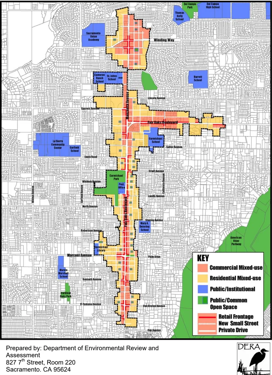
EXECUTIVE SUMMARY
Section titled “EXECUTIVE SUMMARY”The approximately 690-acre Fair Oaks Boulevard Corridor area is located in central Sacramento County, just north of the American River. The proposed project site is located along Fair Oaks Boulevard between Oak and Marshall Avenues and along Manzanita Avenue between Fair Oaks Boulevard and Bourbon Drive. Implementation of the proposed project would result in a mixed-use corridor which is indented to be a community center for the Carmichael area.
This document describes mitigation measures that would be implemented to reduce project-generated operational emissions of the ozone precursors (reactive organic gases [ROG] and oxides of nitrogen [NOX]) by 15% in accordance with policies of the Sacramento County General Plan Air Quality Element (General Plan) requiring ‘a 15 percent reduction in emissions from the level that would be produced by a base-case project assuming full trip generation per the current Institute of Transportation Engineers (ITE) Trip Generation Handbook’(Sacramento County1993) and as recommended by the Sacramento Metropolitan Air Quality Management District (SMAQMD). This plan also meets the requirements of the California Environmental Quality Act (CEQA) that mitigation be implemented to the extent feasible in order to reduce significant adverse environmental impacts. SMAQMD has determined that a 15% reduction in operational emissions of ozone precursors constitutes feasible mitigation.
Mitigation measures found in this document are from the SMAQMD ‘Recommended Guidance for Land Use Emission Reductions’ (SMAQMD 2007). Mitigation measures along with point values being applied to the Fair Oaks Boulevard Corridor Plan can be found in Table AQ-1. Not all measures found in the SMAQMD guidance document are applicable to the project. Only those measures which can be used are discussed in the following sections of the Operational Air Quality Mitigation Plan (AQMP).
Table AQ-1: Proposed Operational Air Quality Mitigation Plan Summary
Section titled “Table AQ-1: Proposed Operational Air Quality Mitigation Plan Summary”| Category/Measure | Description | Point Value |
|---|---|---|
| Bicycle/Pedestrian/Transit Measures 4. Proximity to bike path/ bike lanes | Entire project is located within 1/2 mile of an existing Class I or Class II bike lane and project design includes a comparable network that connects the project uses to the exiting offsite facility. | 0.625 |
| Bicycle/Pedestrian/Transit Measures 5. Pedestrian network | The project provides a pedestrian access network that internally links all uses and connects to all existing or planned external streets and pedestrian facilities contiguous with the project site. | 1 |
| Bicycle/Pedestrian/Transit Measures 6. Pedestrian barriers minimized | Site design and building placement minimize barriers to pedestrian access and interconnectivity. Physical barriers such as walls, berms, landscaping, and non-residential uses that impede bicycle or pedestrian circulation are eliminated. | 1 |
| Bicycle/Pedestrian/Transit Measures 7. Bus shelter for existing transit service | Bus or Streetcar service provides headways of one hour or less for stops within 1/4 mile; project provides safe and convenient bicycle/pedestrian access to transit stop(s) and provides essential transit stop improvements (i.e., shelters, route information, benches, and lighting). | 1 |
| Bicycle/Pedestrian/Transit Measures 9. Traffic calming | Project design includes pedestrian/bicycle safety and traffic calming measures in excess of jurisdiction requirements. Roadways are designed to reduce motor vehicle speeds and encourage pedestrian and bicycle trips by featuring traffic calming features. | 1 |
| Parking Measures 12. Parking reduction beyond code | Provide parking reduction less than code. Special review of parking required. Recommend a Shared Parking strategy. | 6 |
| Parking Measures 13. Pedestrian pathway through parking | Provide a parking lot design that includes clearly marked and shaded pedestrian pathways between transit facilities and building entrances. | 0.5 |
| Site Design Measure 19. Street grid | Multiple and direct street routing (grid style). | 1 |
| Mixed-Use Measure 23. Suburban mixed-use | Have at least three of the following on site and/or offsite within 1/4 mile: Residential Development, Retail Development, Park, Open Space, or Office. | 3 |
Total Credit: 15.125
Emissions Reduction Target: 15.00
Source: SMAQMD 2007. Data compiled by DERA 2009.
The Fair Oaks Boulevard Corridor Plan focuses primarily on the redevelopment of an existing developed, aging area with mixed-use development and other ‘smart growth’ strategies which inherently lend to improved air quality. Smart growth strategies include providing a mix of transportation options including walkable paths, bike lanes and bus turn outs; providing for mixed-use development with multiple uses in one building or a blend of multiple uses throughout a development rather than grouping similar uses; providing for compact community design resulting in high density development including multiple-story and smaller buildings; directing development toward existing communities by building on infill land and urban brown fields; creating a sense of place and creating distinctive and attractive communities while preserving open space.
The ultimate purpose of smart growth is sustainable communities, and is a reaction in part to the recognized health impacts of urban sprawl and vehicle-centric development strategies. Various studies have demonstrated that smart growth development significantly reduces impacts to air quality, water quality, open space/biological resources, and public health. A 2005 Seattle study found that residents of neighborhoods where land uses were mixed and streets are better connected, making non-auto travel easier and more convenient, traveled 26 percent fewer vehicle miles than residents of neighborhoods that were more dispersed and less connected (Lawrence Frank and Company). It has also been demonstrated that the greenhouse gas emission reductions incorporated within California’s Executive Order S-3-05 are unlikely to be achieved just through vehicle efficiency and development of low-carbon fuels - significant vehicle trip reductions will also be required (Yang, et. al.) and can be fostered through smart growth land use policies.
The Fair Oaks Boulevard Corridor Plan includes the smart growth elements noted above and is expected to have an overall benefit to air quality. In addition the measures noted in the table above are intended to reduce air quality impacts by further supporting smart growth principles by increasing pedestrian mobility throughout the plan area and the surrounding communities, decreasing the number of vehicle trips to and within the project area, increasing pedestrian safety and comfort and providing a mix of uses in one area to meet community needs.
INTRODUCTION
Section titled “INTRODUCTION”The Sacramento County Planning and Community Development Department is proposing to adopt the Fair Oaks Boulevard Corridor Plan. Sacramento County and Carmichael community leaders prepared this plan to guide the revitalization and enhancement of Fair Oaks Boulevard, between Oak Avenue and Marshall Avenue, and Manzanita Avenue between the Boulevard and Bourbon Drive. The intent of the plan is to reinvent Carmichael’s Main Street by transforming it into a vibrant mixed-use commercial and residential district. The Corridor Plan will be implemented as a Special Planning Area (SPA).
The purpose of this document is to identify recommended measures to mitigate the operational pollutant (ozone precursors ROG and NOx) emissions associated with the proposed land uses that could occur in the Fair Oaks Boulevard Corridor Plan area by at least 15%. This document has been prepared in accordance with SMAQMD’s recommendations and with Policy AQ-15 of the Sacramento County General Plan Air Quality Element:
- AQ-15: All new major indirect sources of emissions shall be reviewed and modified or conditioned to achieve a reduction in emissions. This indirect source review program will be developed in coordination with SACOG and SMAQMD, and include the following features;
- A 15% reduction in emissions from the level that would be produced by a base-case project assuming full trip generation per the current ITE Trip Generation Handbook.
The following sections of this document detail the proposed project’s existing and planned transportation setting and the proposed Land Use Emission Reduction mitigation measures for the project as directed by the SMAQMD’s Recommended Guidance for Land Use Emission Reductions (SMAQMD 2007). The emission reduction measures are organized into the following categories:
- Bicycle/Pedestrian/Transit Measures;
- Site Design Measures; and
- Parking Measures;
- Mixed-Use Measures
PROJECT DESCRIPTION AND SETTING
Section titled “PROJECT DESCRIPTION AND SETTING”The Fair Oaks Boulevard Corridor Plan area is located in the Carmichael community along Fair Oaks Boulevard and Manzanita Avenue; north, south and east of the intersection of Fair Oaks Boulevard and Manzanita Avenue (refer to Plate AQ-1). The project site is to consist of four districts: Manzanita, East Fair Oaks Boulevard, Main Street, and South Gateway. According to the Draft Corridor Plan (Sacramento County 2009) project area is to contain Commercial Mixed-Use and Residential Mixed-Use designations and the purpose of the proposed plan is to guide the revitalization and enhancement of Fair Oaks Boulevard and its existing adjacent development by creating a string of livable, social and vibrant districts that provide a community center in the Carmichael community area and to reinvent Carmichael’s Main Street consistent with the Carmichael Community Action Plan.
ACCESS CHARACTERISTICS
Section titled “ACCESS CHARACTERISTICS”The Fair Oaks Boulevard Corridor area is located along two major roadways in Sacramento County. Fair Oaks Boulevard and Manzanita Avenue bisect the plan area and provide access to the site from the north, east and south. In addition to these major roadways many other smaller roadways extend into the Plan area from the adjacent communities that surround the site. Listed below are the general location and access routes to the various districts that make up the Plan area.
MANZANITA DISTRICT:
Section titled “MANZANITA DISTRICT:”The Manzanita District can be seen as divided into four quadrants with Manzanita Avenue and Winding Way crossing at its middle and providing the primary access routes into it. In addition Hackberry Lane and Locust Avenue provide access to the southwestern portion of this district.
EAST FAIR OAKS BOULEVARD DISTRICT:
Section titled “EAST FAIR OAKS BOULEVARD DISTRICT:”The East Fair Oaks Boulevard District is generally divided into three sections with Fair Oaks Boulevard and Manzanita Avenue dividing up the district and providing the primary access. Other roadways that provide access to this district are Cypress Avenue to the northwest, Engle Road to the southwest and California and Marshall Avenues to the east.
MAIN STREET DISTRICT:
Section titled “MAIN STREET DISTRICT:”The Main Street District straddles Fair Oaks Boulevard which serves as the primary access roadway to this district. Other roadways providing access to this portion of the plan area include Grant Avenue to the northwest, Landis and Stanley Avenues as well as Palm Dive to the east, and Marconi, Robertson and North Avenues to the west.
Plate AQ-1: Project Location Map
SOUTH GATEWAY DISTRICT:
Section titled “SOUTH GATEWAY DISTRICT:”The South Gateway District also straddles Fair Oaks Boulevard which is the major access route to this district. Kenneth and El Camino Avenues to the west and as well as Oak, Van Alstine and Kenneth Avenues to the east also provide access to this district.
BICYCLE FACILITIES
Section titled “BICYCLE FACILITIES”EXISTING BICYCLE AND PEDESTRIAN SYSTEM
Section titled “EXISTING BICYCLE AND PEDESTRIAN SYSTEM”Existing bicycle facilities and sidewalks are found throughout the project area, although some of bike lanes and sidewalks are discontinuous in nature. Currently Class II bike lanes located within the project area are located along Manzanita Avenue, Cypress Avenue, Stanley Avenue, Marconi Avenue, Van Alstine Avenue and California Avenue. Other Class II bike lanes that are within ½ mile of the project area and have bike lane/route connectivity to the site are on Marshall Avenue, Fair Oaks Boulevard, Jan Drive and Crestview Drive. These bike lanes connect to a number of other bike lanes that run throughout the community. In addition to the Class II bike lanes the project site has connectivity to Garfield Avenue and Sheffield Drive which contain Class III bike routes. The Class III bike route on Sheffield Drive, in turn, has connectivity to the American River Bike Trail; a Class I bike path (refer to Plate AQ-2). It should be noted that, in addition to the aforementioned bike facilities, a number of other roadways in the project area, including large sections of Fair Oaks Boulevard, include Class II bike lane areas; however, according to DOT staff (D. Klinker) some of the bike lanes in the project area are not developed to standards (are lacking signage or proper striping) and cannot be considered viable bike lanes. These areas are not included in this document.
PROPOSED BICYCLE AND PEDESTRIAN SYSTEM
Section titled “PROPOSED BICYCLE AND PEDESTRIAN SYSTEM”As stated in the Fair Oaks Boulevard Corridor Plan, the Road Project incorporated within the Plan will include Class II bike lanes along Fair Oaks Boulevard from Marconi Avenue to Engle Road connecting some of the existing bike lanes in the area (see Attachment A). The Roadway Project also includes sidewalks and streetscaping that will extend from the Boulevard at least 150 feet into the adjacent neighborhoods along existing streets to improve walking connections. In addition, the plan area proposes an interior street system within the project area which is to be developed in a block/grid style to allow for easy pedestrian access into and throughout the project area (refer to Plate AQ-3 and Plate AQ-4).
Plate AQ-2: Existing Bicycle Facilities
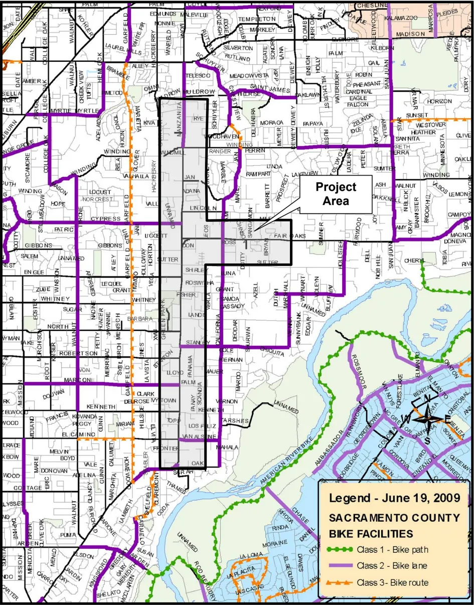
Plate AQ-3: Proposed Northern Interior Street System
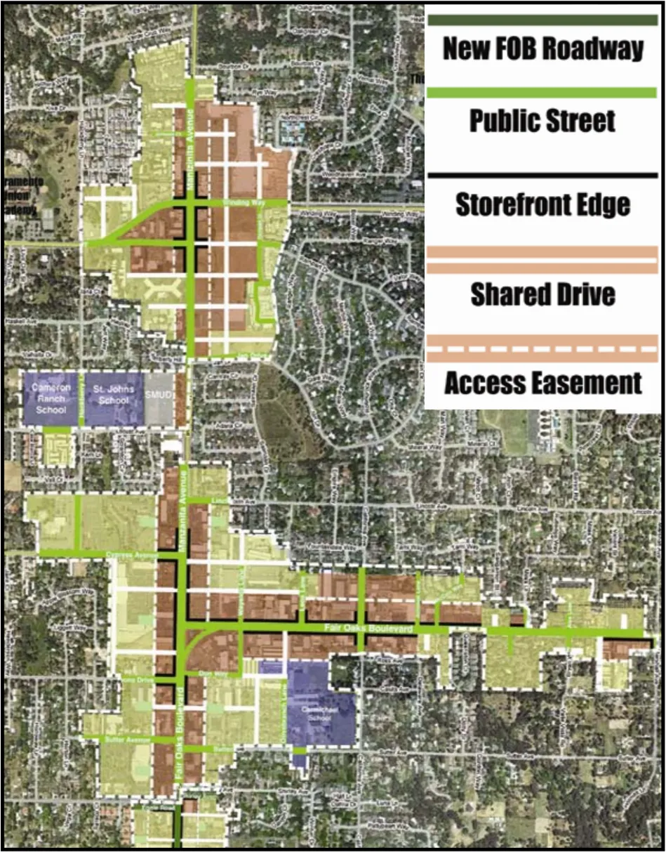
Plate AQ-4: Proposed Southern Interior Street System
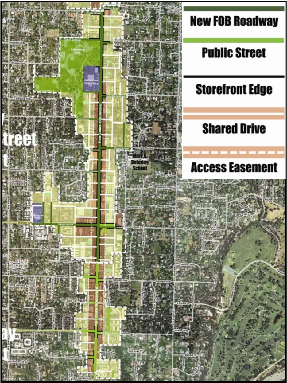
TRANSIT SERVICE FACILITIES
Section titled “TRANSIT SERVICE FACILITIES”EXISTING TRANSIT SERVICE
Section titled “EXISTING TRANSIT SERVICE”The Sacramento Regional Transit District (RT) operates bus service in Sacramento County. Five bus routes serve the project site and include route 22, 23, 25, 10 and 9. These bus routes allow for travel to light rail stations, major destinations points and many locations where bus transfers can be made to facilitate further pedestrian movement (refer to Plate AQ-5: Existing Transit System). The existing transit service in the vicinity of the project site is described below:
Route 22 provides 60-minute service on weekdays and at peak times and in the evenings with 30-minute daytime service on the weekends.
1st bus pulls out at 8:11am and the last run drops off at 8:47pm weekdays.
1st bus pulls out at 8:11am and the last run drops off at 9:47pm Sat.
1st bus pulls out at 9:41am and the last run drops off at 9:47pm Sun and Holidays.
Route 23 provides 15-minute weekday peak service, 30-minute weekday service, 60minute evening service with 30/60-minute service on the weekends.
1st bus pulls out at 5:07am and the last run drops off at 10:40pm weekdays.
1st bus pulls out at 6:27am and the last run drops off at 10:13pm Sat.
1st bus pulls out at 6:39am and the last run drops off at 9:36pm Sun and Holidays.
Route 25 provides 30/60-minute weekday peak service with 60-minute weekday and Sat service. No service on Sun or eves.
1st bus pulls out at 5:56am and the last run drops off at 7:45pm weekdays.
1st bus pulls out at 8:09am and the last run drops off at 7:09pm Sat.
Routes 9 and 10 provide 75-minute peak and weekday service. These routes are “Neighborhood Ride” services and may deviate off route up to 3/4 of a mile to pick up and drop off seniors and disabled passengers which may also affect their times. No Sat, Sun or Holiday service.
Plate AQ-5: Existing Transit System
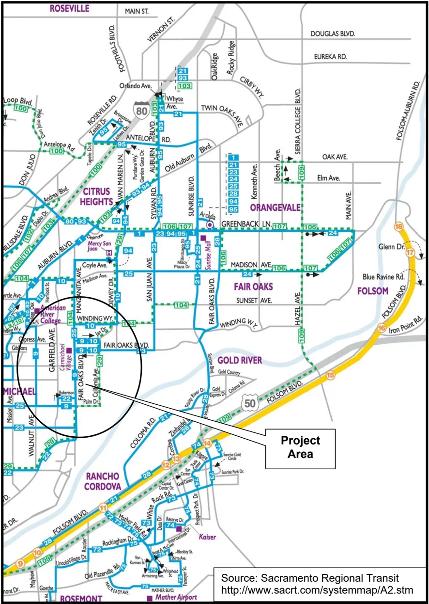
PROPOSED MEASURES
Section titled “PROPOSED MEASURES”The following supporting text and exhibit references detail mitigation measures that would reduce air pollutant emissions from development related land uses. The text describes how measures would be implemented in accordance with the information available at this time. Additional information may be available when redevelopment occurs.
BICYCLE/ PEDESTRIAN/ TRANSIT MEASURES
Section titled “BICYCLE/ PEDESTRIAN/ TRANSIT MEASURES”MEASURE 4: PROXIMITY TO BIKE PATH/ BIKE LANES
Unscaled SMAQMD emissions reduction = 0.625
Scale factor = 1 (entire project)
Scaled mitigation value = 0.625
Department of Transportation (DOT) staff (D. Klinker) has indicated that a number of roadways in the project area currently contain bike paths, bike lanes and bike routes that are developed to current standards (refer to Plate AQ-2). Currently Class II bike lanes located within the project area are located along Manzanita Avenue, Cypress Avenue, Stanley Avenue, Marconi Avenue, Van Alstine Avenue and California Avenue. Other Class II bike lanes that are within ½ mile of the project area and have bike lane connectivity to the site are on Marshall Avenue, Fair Oaks Boulevard, Jan Drive and Crestview Drive.
In addition to the project site having several bike lanes traversing through it and being within one half mile of several others, the roadway project, which is included as part of the Corridor Plan, includes new bike lanes along Fair Oaks Boulevard from Marconi
Avenue to Engle Road to enhance bicycle lane connectivity to the existing bicycle lanes.
The bike lanes are to be class II bike lanes that are 5 feet in width (refer to Attachment A). Also, the Corridor Plan indicates that the project area is built out it will be developed with a block/grid pattern that will allow for pedestrian connectivity throughout the project area as well to the surrounding community and that bike facilities shall be designed for every building site throughout the project area.
Aside from all of the existing facilities and expected improvements related to the Roadway Project and the grid style development pattern, the corridor plan includes the following Circulation Principle that will direct future development within the project area to establish Class II bike lanes along Fair Oaks Boulevard.
The following Circulation Principle of the Corridor Plan pertains to bicycles:
CP 5. Bicycle Access
Establish on-street Class II bicycle lanes along the Boulevard and enhance access from residential streets and the American River Parkway. Every commercial or mixed-use project should include bike racks.
MEASURE 5: PEDESTRIAN NETWORK
Unscaled SMAQMD emissions reduction = 1.00
Scale factor = 1 (entire project)
Scaled mitigation value = 1.00
As stated in the Corridor Plan all of the districts are to be pedestrian oriented and each is to be developed with a block/grid system with internal streets and drives. The block/grid system would allow pedestrian scaled development that creates a walking scale pattern throughout the majority of the plan area and also provides for pedestrian accessibility from the adjacent communities (refer to Plate AQ-3 and Plate AQ-4). The Roadway Project also includes separated sidewalks and streetscaping (refer to Plate AQ-6) that will extend from the Boulevard at least 150 feet into the adjacent neighborhoods along existing streets to improve walking connections (see Attachment A). Building setbacks are intended to establish a consistent walking edge along Fair Oaks Boulevard and connecting side streets. The sidewalk, planter strip, and building setback will provide a combined dimension of at least 16 feet from the back of curb to a storefront.
The following Land Use, Circulation and Community Design Principles of the Corridor Plan pertain to the pedestrian network:
LUP 4. Main Street District: Reinvented Social and Economic Center
Create a mixed-use, transit-oriented Main Street District that provides a variety of commercial services, housing types, pleasant walk able streets, and small gathering places that are connected to Carmichael Park and adjacent residential neighborhoods.
LUP 17. Transit-oriented Investment
New projects shall create comfortable walking environments and improve access to transit.
CP 2. Pedestrian Comfort
Provide wide, well-lit, and well-shaded sidewalks that encourage daytime and nighttime use.
CP 3. Pedestrian/Automobile Buffer
Wherever possible, develop landscaped strips between sidewalks and Fair Oaks Boulevard/Manzanita Avenue to buffer pedestrians from vehicular traffic.
CDP 21. Variety and Quality of Open Space
As part of new development and redevelopment of existing sites, establish an interconnected system that binds the community together through a hierarchy of open spaces, including community parks, plazas, wide pedestrian-oriented sidewalks, and other types of public and private spaces.
Plate AQ-6: Roadway Cross section
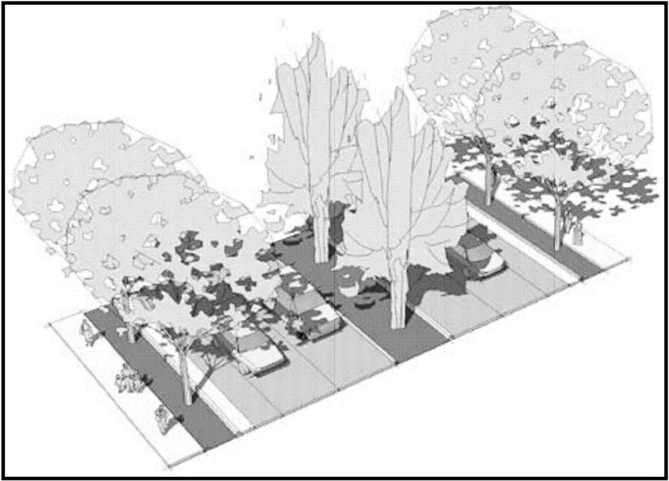
MEASURE 6: PEDESTRIAN BARRIERS MINIMIZED
Unscaled SMAQMD emissions reduction = 1.00
Scale factor = 1 (entire project)
Scaled mitigation value = 1.00
The project does not propose any barriers to pedestrian access, such as sound walls or berms or large roadways. The plan includes a grid system with interior side streets that will connect not only the districts but the neighboring community as well. The plan area will also contain outdoor seating areas, plazas and other open space along connecting side streets as well as storefronts that would connect adjacent parcels. In addition, the plan calls for the provision of four-legged cross walks at four-way signalized intersections and crosswalks on at least two legs at signalized three-way intersections to lessen pedestrian barriers.
The roadway project included in the corridor plan includes eight new crosswalks within the plan area. Four new crosswalks will be located at the intersection of Fair Oaks Boulevard and Landis Avenue, one new crosswalk will be located on the north side of the intersection of Fair Oaks Boulevard and Grant Avenue, one new crosswalk will be located across Fair Oaks Boulevard north of North Avenue, and two new crosswalks will be located at the intersection of Fair Oaks Boulevard and Robertson Avenue.
The following Land Use, Circulation Principles of the Corridor Plan pertain to the pedestrian barriers:
LUP 13. Connected Districts and Neighborhood Centers
Design all new development to provide strong functional land use and circulation links among the Boulevard’s districts and neighborhood centers, to adjacent neighborhoods, and to the community of Carmichael and the region.
CP 1. Pedestrian Priority
Give pedestrian access and comfort priority in site planning and roadway design.
CP 4. Pedestrian Connections to Surrounding Neighborhoods
that draw people from surrounding neighborhoods to the Boulevard’s districts. Create inviting pedestrian connections, through sidewalk improvements, additional landscaping, and street trees, and commercial uses
CP 8. Side and Neighborhood Streets Improvements
Enhance existing local side and neighborhood streets through street repairs, connecting sidewalks, grading, and landscaping.
MEASURE 7: BUS SHELTER FOR EXISTING TRANSIT SERVICE
Unscaled SMAQMD emissions reduction = 0.25-1.00
Scale factor = 1 (entire project)
Scaled mitigation value = 1
Currently RT maintains five bus routes through the project area (refer to ). Fair Oaks Boulevard, Manzanita Avenue, Marconi Avenue, Winding Way, California Avenue and Lincoln Avenue are all provided RT service. A number of bus stops are in the project area including several sheltered bus stops. The Corridor Plan indicates that approximately 26 bus stops are in the plan area with 7 bus turnouts. It is also noted that the plan also seeks to build upon the existing system by providing “enhanced bus stops” which include bus shelter screening, shading and lighting next to bus turnouts within the Main Street District, Manzanita District, East Fair Oaks District and along key cross streets.
The following Circulation and Streetscape Principles of the Corridor Plan pertain to the transit service:
CP 6. Transit Access
Enhance access to transit through street design and related site planning on private property.
CP 7. Enhanced Transit Stop
Install bus turnouts where feasible and install shelters at every bus stop along the thin the planning area. Boulevard wi
SP7. Bus Shelters
Provide well-designed bus shelters throughout the Boulevard’s districts.
MEASURE 9: TRAFFIC CALMING
Unscaled SMAQMD emissions reduction = 0.25- 1.0
Scale factor = 1 (entire project)
Scaled mitigation value = 1
The Corridor Plan calls for the expansion of the Fair Oaks Boulevard right-of-way to allow for wider sidewalks, bike lanes, and planting strips; in certain locations it is planned that the County will acquire 10 to 12 feet of private property to improve th streetscape along Fair Oaks Boulevard. The plan also calls for vegetated medians and planting strips within the plan area (refer to ). A new raised median is proposed as part of the roadway project for Fair Oaks Boulevard from Marconi to Engle. The Corridor Plan also calls for other traffic calming techniques to be employed by future development including changes in paving materials (pavers, stained concrete stone) at crosswalks, drop-offs and lobby zones; reducing the number of curb cuts along roadways; having sidewalks with raised curbs within parking areas; having sidewalks adjacent to store fronts wide enough to accommodate sitting areas and landscaping and having an interconnected private street system that is pedestrian friendly with sidewalks.
The following Circulation and Streetscape Principles of the Corridor Plan pertain to traffic calming and pedestrian safety:
CP 3. Pedestrian/Automobile Buffer
Wherever possible, develop landscaped strips between sidewalks and Fair Oaks Boulevard/Manzanita Avenue to buffer pedestrians from vehicular traffic.
CP 9. Remove Center Turn Lanes
Enhance driver and pedestrian safety by replacing center turn lanes with medians and left turn pockets.
CP 12. Speed Reduction and Traffic Flow
Reduce speeding and improve flow along the Boulevard by coordinating traffic signals.
CP 14. On-street Parking
Include on-street parking as part of connecting side street improvements as shared replacement parking in the roadway project area.
SP2. Street Trees
Use canopy trees, median trees, and secondary street trees that emphasize the symbolic importance, scale, and pedestrian comfort required for each district.
SP5. Paving Materials
Emphasize the presence of pedestrian zones, connections, and crosswalks by highlighting them with distinctive paving patterns, colors and materials.
In addition to the Corridor Plan proposals DOT has indicated that countdown signal timers will be incorporated into the Roadway Project on Fair Oaks Boulevard between Marconi Avenue and Engle Road.
PARKING MEASURES
Section titled “PARKING MEASURES”MEASURE 12: PARKING REDUCTION BEYOND CODE
Unscaled SMAQMD emissions reduction = 0.1-12.0
Scale factor = 1 (entire project)
Scaled mitigation value = 6
Since it is currently unknown what uses will ultimately be developed within the plan area calculating the amount of parking that would be required is not feasible at this time. In turn, calculating the reduced amount of parking expected from development within the plan area is also currently infeasible. However, one of the objectives of the Corridor Plan is to change the relationship between transportation patterns and development standards within the corridor area. The parking standards within the Corridor Plan allow for a greater flexibility in the provision of parking and reduce the negative impacts of excessive parking. The Corridor Plan provides opportunities for shared-use parking agreements between adjacent parcels when cross access easements are used and driveways are closed; allows parking reductions to reflect uses that have complementary demand patterns and allows up to a six percent reduction in parking for uses that provide transit support facilities such as bike lockers and showers.
As shown in the table parking requirements within the plan area will allow for a parking reduction beyond what is currently allowed by code.
The following Circulation Principle of the Corridor Plan pertains to parking reductions:
CP 13. Joint/Shared Parking
Promote jointly used/shared parking facilities among the office, retail, and institutional uses, since such uses tend to have different peak parking demand periods during the day or week.
MEASURE 13: PEDESTRIAN PATHWAY THROUGH PARKING
Unscaled SMAQMD emissions reduction = 0.5
Scale factor = 1 (entire project)
Scaled mitigation value = 0.5
Pedestrian scaled block patterns with storefronts, residential entrees and lobbies, and commercial buildings oriented toward the streets are proposed in order to facilitate pedestrian access from adjacent public transit. In addition, the Corridor Plan will require pedestrian walkways within parking lots plus crosswalks for larger commercial lots to aid pedestrian access. Also, the Plan requires frontage improvements on all public and private streets and notes that pedestrian connections to transit facilities shall be easy to navigate, safe, comfortable and friendly.
The Parking section of the Corridor plan details parking requirements within the plan area. The parking section states the following in regard to pedestrian pathways and parking areas:
Require pedestrian walkways within parking lots (down middle of parking field) plus crosswalks for larger commercial lots
SITE DESIGN MEASURES
Section titled “SITE DESIGN MEASURES”MEASURE 19: STREET GRID
Unscaled SMAQMD emissions reduction = 1.0
Scale factor = 1 (entire project)
Scaled mitigation value = 1.00
The Corridor Plan includes a reconfigured development pattern that results in a grid style block pattern similar to the downtown area. The Plan notes that traditional residential-scaled blocks (between one and two acres in size) shall be used as a reference for the pattern and scale that organizes residential and commercial development in the plan area. The Plan indicates that the block pattern shall result in a pedestrian-scaled neighborhood that is comfortable for pedestrians and increases access options for the project area as well as the surrounding communities. The plan also indicates that renovated and new commercial buildings and centers shall have an interconnected system of roadways, pedestrian walks and sidewalks that connect the plan area to the adjacent neighborhoods.
MIXED-USE MEASURES
Section titled “MIXED-USE MEASURES”MEASURE 23: SUBURBAN MIXED-USE
Unscaled SMAQMD emissions reduction = 3.0
Scale factor = 1 (entire project)
Scaled mitigation value = 3.00
The Corridor Plan proposes mixed-use development for the majority of the plan area with some public/institutional development as well as some public/open common space. The intent of the Plan is to situate commercial mixed-use development along the major roadways within the project area with residential mixed-uses just behind. The designations in the plan area will include Commercial Mixed-Use; Residential MixedUse; Public/Institutional and Public/Common Open Space (refer to Plate AQ-7).
Plate AQ-7: Proposed Land Use
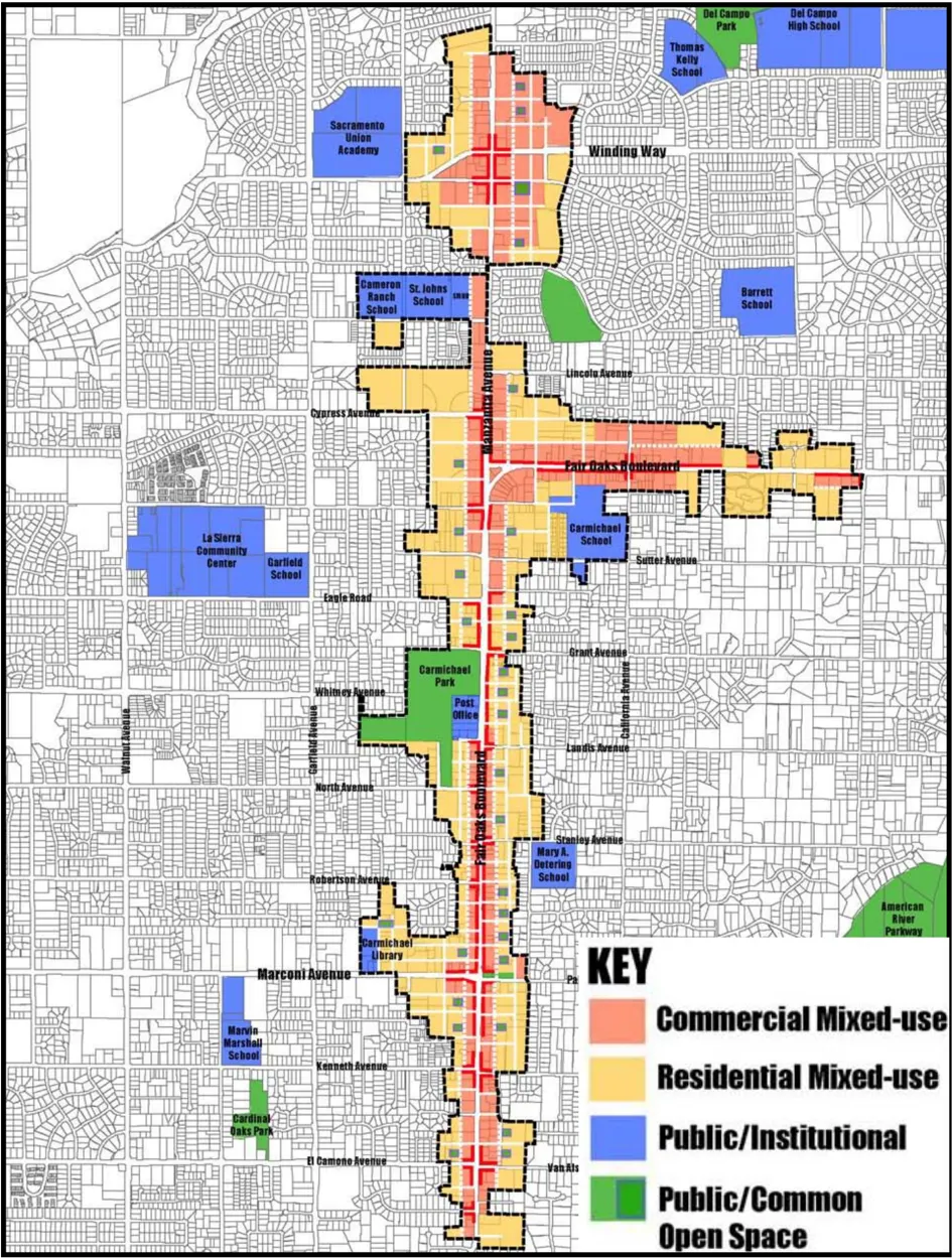
REFERENCES
Section titled “REFERENCES”County of Sacramento, Department of Planning & Community Development. “Fair Oaks Boulevard Corridor Plan” March, 31, 2009 (draft).
County of Sacramento, Department of Planning & Community Development. “Fair Oaks Boulevard Concept Plan” April, 2006.
http://www.sacrt.com/systemmap/A2.stm
Klinker, Dan. “Existing bike lanes in the Carmichael community.” E-mail to Kevin Messerschmitt. 15 June. 2009.
“How Land Use and Transportation Systems Impact Public Health: A Literature Review of the Relationship Between Physical Activity and Built Form” Lawrence D. Frank. PhD and Mr. Peter Engelke. City and Regional Planning Program College of Architecture Georgia Institute of Technology http://www.sacrt.com/systemmap/A2.stm
“Identifying Options for Deep Reductions in Greenhouse Gas Emissions from California Transportation: Meeting an 80% Reduction Goal in 2050 Full Report including Policymaker Summary and Appendix” Christopher Yang, David McCollum, Ryan McCarthy, Wayne Leighty. University of California at Davis, One Shields Avenue. Davis, California.
Pair, Chris. “Fair Oaks Boulevard Corridor Plan Bus Service Frequency.” E-mail to Kevin Messerschmitt. 22 May. 2009.
Sacramento Metropolitan Air Quality Management District, ‘Recommended Guidance for Land Use Emissions Reductions, Version 2.4’ August 15, 2007.