Madison Avenue at Fair Oaks Boulevard PDC
Sacramento County Zoning Code
Madison Avenue at Fair Oaks Boulevard County-Initiated Planned Development Ordinance
Section titled “Sacramento County Zoning Code Madison Avenue at Fair Oaks Boulevard County-Initiated Planned Development Ordinance”Adopted June 23, 1976
Amended October 18, 1979 & August 4, 1983 & January 23, 1991 & May 26, 1999
76-PDC-02
Adopted by ZMA #3501
Amended by 1979-0385 [76-PDC-2A] & 1982-1032 [Known as 76-PDC-2A for 233-0142-005 only] & 1990-0622 [76-PDC-2B] & 1998-0371 [76-PDC-2C]
ORDINANCE REGULATING ENTIRE PDC AREA
Section titled “ORDINANCE REGULATING ENTIRE PDC AREA”SECTION I
Section titled “SECTION I”Section 23.01.179 and 180 of the Zoning Code of Sacramento County, Ordinance No. 1111, which incorporates Comprehensive Zoning Plan, 356/200 and 364/200 are amended to change the property described in Exhibit “A” on said Comprehensive Zoning Plans to the LC (PDC) zone.
SECTION II
Section titled “SECTION II”This section was never filled out on the adopted Ordinance. However, the Ordinance was formally amended into Section 101-401.
Chapter 1, Article __ of the Zoning Code of Sacramento County Ordinance No. 1111 as amended is hereby amended by adding thereto:
Section 23.01.__
SECTION III
Section titled “SECTION III”Exhibit “A” attached to this ordinance is incorporated herein and made part of this ordinance for all purposes. The exhibit is on file in the Office of the Clerk of the Board of Supervisors.
SECTION IV. PERMITTED USES
Section titled “SECTION IV. PERMITTED USES”The uses designated in the LC zone, Sections 23.10.012, 23.10.013 and 23.10.014 of the Zoning Code are permitted or conditionally permitted as specified in those sections for the property described in Exhibit “A”.
SECTION V. PERFORMANCE AND DEVELOPMENT STANDARDS
Section titled “SECTION V. PERFORMANCE AND DEVELOPMENT STANDARDS”[AMENDED 01-23-1991][AMENDED 05-26-1999]
Exhibit “A” and “B” within subsection (D) shall mean Exhibit “A” for 1990-0622 and Exhibit “B” for 1998-0371.
- The standards set forth in Sections 23.10.053 and 23.10.055 of the Zoning Code apply to the development of the property described in Exhibit "A".
- A 25 ft. wide landscaped strip shall be provided adjacent to all street rights-of-way.
- Commercial structures shall not be more than one story in height. Structures used for residential purposes shall not exceed two stories or 35 feet.
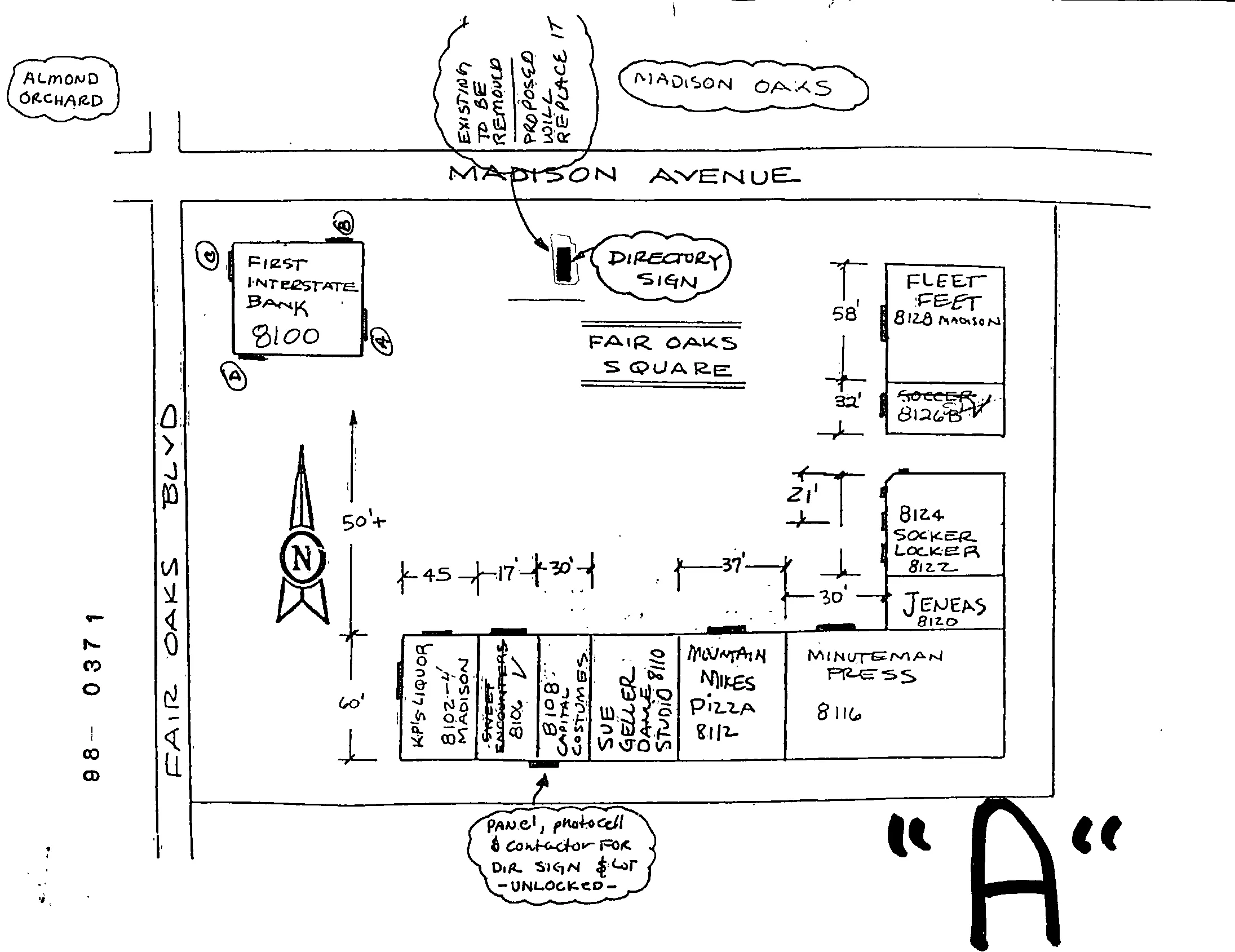
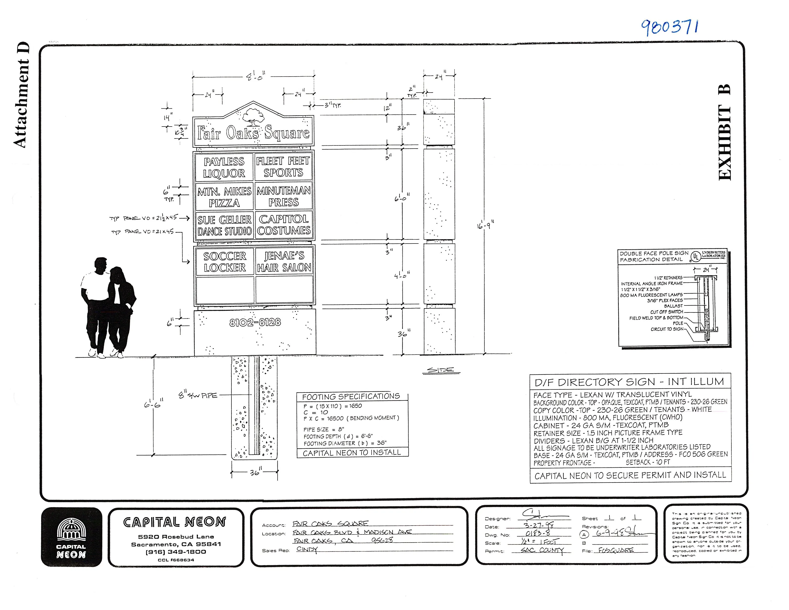
- Signs shall be placed flat against the building and shall not exceed 1 sq. ft. per foot of building frontage facing the street. There shall be no flashing, moving or animated signs. One freestanding directory sign as located per Exhibit "A" and described in Exhibit "B" shall be authorized.
- Final Development Plans including elevations, parking layout, signing and landscaping plans including a species list must be approved by the Project Planning Commission, subject to appeal to the Board of Supervisors as provided in the Zoning Code.
SECTION VI. INTENT OF THE BOARD OF SUPERVISORS
Section titled “SECTION VI. INTENT OF THE BOARD OF SUPERVISORS”The existing uses surrounding these parcels include single family residences, a large park, and a public library. Two major streets, Madison Avenue and Fair Oaks Boulevard, provide access and frontage to the site. The (PDC) zone is considered an appropriate tool to protect the existing residents from development which could create a nuisance in their established residential neighborhood. The review of plans by the Board of Supervisors will insure that development on the site is designed to be aesthetically pleasing and compatible with the residential character of the neighborhood.
EXHIBIT A
Section titled “EXHIBIT A”LC (PDC)
Beginning at the Northeast corner of Lot A, Northridge Hills Unit No. 1, the official plat of which is recorded in the office of the Recorder of Sacramento County in Book 42 of Maps, Map No. ; running thence:
- thence S. 00°14’30“ E. 80.41 feet;
- thence S. 09°09’55“ W. 374.57 feet;
- thence S. 52°04’30“ W. 261.06 feet;
- thence S. 89°35’ E. 178.11 feet more or less to the Westerly Right-of-Way line of Fair Oaks Blvd;
- thence Northerly along said West line of Fair Oaks Blvd. 21 feet more or less to the Northerly Right-of-Way line of Temple Park Road;
- thence S. 88°56’44“ E. along said Northerly Right-of-Way line of Temple Park Road 400 feet;
- thence N. 02°24’56“ W. 582 feet to the Southerly Right-of-Way line of Madison Ave.;
- thence Easterly along said Southerly Right-of-Way line of Madison Ave., 847.79 feet more or less to the point of beginning.
SECTION V EXHIBIT A
Section titled “SECTION V EXHIBIT A”[ADDED 10-18-1979 AS SIGN EXHIBIT][AMENDED 01-23-1991]
Exhibit “A” of 1990-0622
SECTION V EXHIBIT B
Section titled “SECTION V EXHIBIT B”[ADDED 01-23-1991][AMENDED 05-26-1999]
Exhibit “B” of 1998-0371
ORDINANCE REGULATING APN 233-0142-005 ONLY
Section titled “ORDINANCE REGULATING APN 233-0142-005 ONLY”Adopted August 4, 1983
76-PDC-02-A (233-0142-005 ONLY)
Adopted by 1982-RZ-UP-VA-SR-PA-1032 (Northridge Fraternity Association)
Ordinance 72-PD-2A was initially codified on October 18, 1979 for the entire PD. This Ordinance, also known as Ordinance 72-PD-2A, only regulates APN 233-0142-005.
SECTION I
Section titled “SECTION I”Sections 101-144 and 101-145 of the Zoning Code of Sacramento County, Ordinance No. 83-10, which incorporates Comprehensive Zoning Plan, 356/200 and 364/200 are amended to change the Development Standards for that portion of the established LC (PDC) zone as described in Exhibit “B”
SECTION II
Section titled “SECTION II”Section 101-401, Chapter 1, Article 3 of the Zoning Code of Sacramento County Ordinance No. 83-10, as amended, is hereby amended as follows:
County Initiated Planned Development Ordinance 76-PDC-2 and 76-PDC-2A commonly known as the “Madison-Fair Oaks Boulevard PD.”
SECTION III
Section titled “SECTION III”Exhibit “B” attached to this ordinance is incorporated herein and made part of this ordinance for all purposes. The exhibit is on file in the Office of the Clerk of the Board of Supervisors.
SECTION IV. PERMITTED USES
Section titled “SECTION IV. PERMITTED USES”The uses designated in the LC zone, Sections 225-11, 225-12, 225-13 and 225-14 of the Zoning Code are permitted or conditionally permitted as specified in those sections for the property described in Exhibit “B”.
SECTION V. PERFORMANCE AND DEVELOPMENT STANDARDS
Section titled “SECTION V. PERFORMANCE AND DEVELOPMENT STANDARDS”The property described in Exhibit “B” shall be regulated by the following Performance and Development Standards:
- The standards set forth in Sections 225-42 and 315-40 of the Zoning Code apply to the development of the property.
- A 25 ft. wide landscaped strip shall be provided adjacent to all street rights-of-way.
- Commercial structures shall not be more than one story in height unless approved by the Project Planning Commission. In no case shall commercial structures exceed two stories or 35 feet. Structures used for residential purposes shall not exceed two stories or 35 feet.
- Signs shall be placed flat against the building and shall not exceed 1 sq. ft. per foot of building frontage facing the street. There shall be no flashing, moving or animated signs; pole signs and off-site signs are prohibited. A maximum of two (2) monument signs measuring no greater than 2 feet high and 10 feet wide mounted on a base no higher than 3 feet high shall be allowed within the area governed by this ordinance.
- Final Development Plans including elevations, parking layout, signing and landscaping plans including a species list must be approved by the Project Planning Commission, subject to appeal to the Board of Supervisors as provided in the Zoning Code.
SECTION VI. INTENT OF THE BOARD OF SUPERVISORS
Section titled “SECTION VI. INTENT OF THE BOARD OF SUPERVISORS”The existing uses surrounding these parcels include single family residences, a large park, and a public library. Two major streets, Madison Avenue and Fair Oaks Boulevard, provide access and frontage to the site. The (PDC) zone is considered an appropriate tool to protect the existing residents from development which could create a nuisance in their established residential neighborhood. The review of plans by the Board of Supervisors will insure that development on the site is designed to be aesthetically pleasing and compatible with the residential character of the neighborhood.
EXHIBIT B
Section titled “EXHIBIT B”In the State of California, County of Sacramento, and being:
A portion of the North 110 acres of the Southeast 1/4 of Section 1, T. 9 N., R. 6 E., M.D.B. & M., as projected into Rancho San Juan, described as follows:
Beginning at the East one-quarter corner of said Section 1, being also the Southwest corner of the Northeast one-quarter section of Section 6, T. 9 N., R. 7 E., M.D.B. & M., as the same is shown on the Record of Survey “Property of Cleo L. Jones” filed in the office of the County Recorder of Sacramento County, July 28, 1948, in Book 6 of Surveys, Map No. 29, thence from said point beginning South 00°24’56“ East 316 feet along the West line of Fair Oaks Boulevard to a 2“x2” redwood stake stamped L.S. 2217, thence South 88°56’44“ West 400.00 feet to a similar stake; thence North 00°24’56“ West 316.00 feet to a similar stake set in the North line of said North 110 acres of the Southeast one-quarter of Section 1, thence North 88°56’44“ East 400.00 feet along a fence marking said line to the point of beginning.