

Mather Field SPA
Sacramento County Zoning Code
Mather Field Special Planning Area Ordinance
Section titled “Sacramento County Zoning Code Mather Field Special Planning Area Ordinance”Adopted May 20, 1992
Amended September 13, 2016
Adopted by ZMA #4952 / 1992-ZOB-0430 (U.S. Department of Defense)
Amended by PLNP2013-00044 (SZC-2016-0014)
603-10. INTENT.
Section titled “603-10. INTENT.”It is the intent of the Sacramento County Board of Supervisors in adopting this Special Planning Area to:
-
Facilitate the conversion of Mather Field from a military air base to a mixture of public and private uses.
-
Promote the cohesive and comprehensive development of various portions of Mather Field.
-
Provide flexibility in the types of uses that may be permitted at Mather Field through the identification of several mixed-use zones.
-
Provide adequate regulation to ensure quality development through the establishment of development standards and design guidelines and by conducting design review of signs, new construction and certain exterior improvements.
-
Provide a design review process to ensure that the development standards and design guidelines are adhered to in order to ensure the cohesive and high quality development and improvement of the Mather Field Specific Plan area.
-
Address the needs of the Department of Airports in the operation of the Mather Airport, including: the attraction of air cargo businesses, manufacturing and industrial businesses, and as a center for general and corporate aviation through the identification of an airport zoning district and its subareas.
-
Promote a pedestrian-oriented environment within developed sub-areas of the Specific Plan area by, including a mixture of commercial, office and public uses.
-
Provide linkages between Mather Field and the Cordova community, including: visual, pedestrian, roadway, bikeway and transit linkages incorporating Mather Field into the larger Cordova community.
-
Provide opportunities for the private use of property for industrial uses in the Industrial District.
-
Facilitate future development of a new Specific Plan for the portion of the Mather Field area located generally south of Mather Lake and southeast of the Mather Golf Course, east of Zinfandel Drive and north of Kiefer Boulevard which plan shall be in conformance with:
-
A plan inclusive of a variety of housing choices
-
A plan for accommodation of a percentage of low and very low income residential units required by law per the County’s General Plan Housing Element which implements the Regional Housing Needs Allocation (RHNA)
-
An infrastructure Master Plan and Financing Plan
-
An Urban Services Plan
-
A demonstration of consistency with applicable County plans
-
A discussion of the jobs/housing balance in the context of the Mather Field Specific Plan
-
A discussion of the plan’s relationship to regional planning efforts
-
Incorporate the Mather Stakeholder Group’s consensus points, including an environmental education campus, preservation of the critter pool and spadefoot pool and their associated watersheds, creation of a new east/west open space corridor in the Urban Development Area, as well as a new north/south connecting corridor from the east/west corridor to the critter pool area as conceptually shown in Section 603-20.3.6, use of best management practices identified in the Revised Final Environmental Impact Report related to stormwater quality and erosion and sedimentation control, reduction of overall project impacts to wetlands and special status species by identifying additional restoration and avoidance areas onsite, and possible restoration opportunities offsite.
-
603-11. APPLICABILITY.
Section titled “603-11. APPLICABILITY.”The provisions of this Article shall apply to the land area shown in Section 603-20.1. In any case, where this Article does not provide direction or regulation regarding a specific use or development standard, all applicable provisions of the Zoning Code shall apply. To the extent that any of the provisions of this Article conflict with other provisions of the Zoning Code, the provisions of this Article shall prevail. All land that was once County jurisdiction and contemplated in the 1997 Mather Field Specific Plan and Special Planning Area documents, but is now the jurisdiction of the City of Rancho Cordova, has been excised from the revised Specific Plan and SPA documents.
603-12. DEFINITIONS.
Section titled “603-12. DEFINITIONS.”For the purposes of this Article, the following definitions apply:
Mather Field Specific Plan Design Guidelines. Those guidelines that are adopted as part of the Mather Field Specific Plan and included in the Specific Plan text, as may be amended from time to time.
Mather Field Specific Plan Public Facilities Financing Plan: That Public Facilities Financing Plan as defined in the Mather Field Specific Plan that identifies the public facilities that are necessary to serve the proposed land uses in the Mather Field Specific Plan area.
Mather Field Specific Plan: That document which includes a text with goals and policies governing development of Mather Field. The Specific Plan was adopted by Resolution 97-0545 by the Sacramento County Board of Supervisors with major revisions adopted by Resolution #2016-0705 by the Sacramento County Board of Supervisors. See Section 603-20.8 for conditions of approval, mitigation measures, and findings adopted for PLNP2013-00044. The boundaries of the Specific Plan are coterminous with those of the Special Planning Area as depicted in Section 603-20.1 and the land uses are depicted in Section 603-20.2.5.
Mather Regional Park Land Use Plan. That document which was adopted by Resolution 97-0546 by the Sacramento County Board of Supervisors to govern development of the Mather Regional Park, as may be amended from time to time by the Board.
Zoning Code. The Zoning Code of Sacramento County, as adopted and including any amendments or additions.
603-13. AMENDMENTS AND DEVIATIONS.
Section titled “603-13. AMENDMENTS AND DEVIATIONS.”- Amendments to the Mather Field Specific Plan, this Article, or requests for rezones, variances, and conditional use permits shall be reviewed pursuant to adopted County procedures as set forth in Title 21 of the County Code and in the applicable provisions of the Zoning Code unless otherwise specified within this Article.
- Deviations from the Development Standards provided in this Article may be considered through the Design Review process as set forth in Section 603-16. The appropriate authority may grant a deviation from a development standard set forth in this Article to the extent such deviation is expressly authorized by the provisions of this Article.
603-13.1 ENVIRONMENTAL IMPACT MITIGATION MEASURES.
Section titled “603-13.1 ENVIRONMENTAL IMPACT MITIGATION MEASURES.”Pursuant to the Revised Final Environmental Impact Report released on June 9, 2016 for the Mather Field Special Planning Area, the following policies are applicable to redevelopment or future development, as noted below. Refer to the adopted Mitigation Monitoring and Reporting Program for the full text of the mitigation measures referenced below. These policies are based upon the adopted Mitigation Measures, and are not all inclusive of the required Mitigation Measures for development in the Mather Field Special Planning Area, nor do they replace the adopted Mitigation Measures.
- Future applicants for residential projects shall reduce residential GHG emissions to below the significance threshold of 1.33 MT per capita, pursuant to Mitigation Measure CC-1.
- Future applicants for commercial and industrial projects shall reduce commercial emissions to below the significance threshold of 7.87 MT CO2 per Kft2, pursuant to Mitigation Measure CC-2.
- All development and redevelopment projects shall be in compliance with the Federal Aviation Regulation (FAR) Part 77, Objects Affecting Navigable Airspace, pursuant to Mitigation Measure AC-2.
- All development or redevelopment within the Mather Airport Approach/Departure and Overflight Safety Zones shall be consistent with the allowed land uses detailed in the "Land Use Compatibility for Airport Safety" table, pursuant to Mitigation Measure AC-3.
- All future construction projects shall include an ozone precursor analysis, pursuant to Mitigation Measure AQ-1.
603-14. PERMITTED AND CONDITIONALLY PERMITTED USES.
Section titled “603-14. PERMITTED AND CONDITIONALLY PERMITTED USES.”The Mather Field Special Planning Area is divided into various use Districts and Subareas as indicated in Sections 603-20.2 and 603-20.2.5 and described below. The provisions of this subsection describe the permitted and conditionally permitted uses in each District and Subarea. In the event that a use is permitted or conditionally permitted under two or more different zones, the land use zone that permits the use shall apply. If the use is permitted in one zone and requires a use permit in the other, the use shall be permitted. The permitted and conditionally permitted uses for each District and Subarea are:
A. The Main Base District.
Section titled “A. The Main Base District.”The boundaries of the Main Base District, including the Main Base Subarea and Open Space Subarea, are depicted in Sections 603-20.2 and 603-20.2.5. The Main Base Subarea is intended to accommodate a variety of commercial, office and open space uses in a pedestrian- oriented environment. Residential uses may occur only as permitted by adopted zoning code provisions regulating the underlying zones of each subarea. The Open Space Subarea is intended to create a park-like corridor with open space and recreation activities. Note: A majority of the Main Base District and its two subareas is within the jurisdiction of the City of Rancho Cordova. These standards only apply to the areas still under County of Sacramento jurisdiction.
-
The Main Base Subarea. The Main Base Subarea is located generally south of Norden Avenue, east of DeBellevue Street, north of Macready Avenue, and west of Bullard Street with the exception of the Open Space Subarea, as shown in Section 603-20.2.
Permitted uses within the Main Base Subarea are those uses permitted in the Shopping Center (SC) Land Use Zone as listed in Zoning Code Section 225-31, and in the Business and Professional Office (BP) Land Use Zone as listed in Zoning Code Section 225-21 both of which are subject to the special conditions referenced in Section 225-14. Additional permitted uses are those permitted in the Industrial-Office Park (MP) Land Use Zone as listed in Zoning Code Section 230-11, and subject to special conditions referenced in Section 230-13, and the Commercial Use Tables, Zoning Code Section 225-11 and subject to special conditions referenced in Section 225-14.
-
The Open Space Subarea. The Open Space Subarea is located generally south of Norden Avenue, east of Von Karman Street, north of Macready Avenue, and west of Whitehead Street as shown in Section 603-20.2. Permitted uses within the Open Space Subarea are those uses permitted in the Recreation (O) Land Use Zone as listed in Zoning Code Section 220-21 and subject to special conditions referenced in Section 201-04 with two exceptions.
Uses not otherwise provided for in the Recreation Land Use Zone may be permitted upon a determination by the Planning Director pursuant to provisions of Zoning Code Section 100-30.5 and the issuance of a conditional use permit by the Board of Supervisors.
B. The Mather Airport District.
Section titled “B. The Mather Airport District.”The boundaries of the Mather Airport District are identified in Section 603-20.2 and 603-20.2.5. The Mather Airport District is intended to provide for the operation of the Mather Airport, industrial activities related to the Airport, and other non-airport industrial activities as determined appropriate by the Department of Airports.
-
The North Airport Subarea. The boundaries of the North Airport Subarea are identified in Section 603-20.2. Permitted uses within the North Airport Subarea are those uses permitted in the Light Industrial (M-1) Land Use Zone as listed in Zoning Code Section 230-21 and in the Industrial-Office Park (MP) Land Use Zone as listed in the Industrial Use Tables, Zoning Code Section 230-11 and subject to special conditions referenced in Section 230-13 and the Commercial Use Tables, Zoning Code Section 225-11 and subject to special conditions referenced in Section 225-14. In addition, the following uses are permitted: a fuel farm; aircraft engine testing; activities related to the manufacture, maintenance, repair and storage of aircraft; freight depot/sorting facility and truck terminal; circuit board and semiconductor manufacturing; boat building; automotive repair which is part of a quasi-governmental use; and activities related to the operation of the Mather Field Airport.
-
The Airport Runway and Environs Subarea. The boundaries of the Airport Runway and Environs Subarea are identified in Section 603-20.2. The southern boundary of this Subarea is intended to be the ultimate alignment of the extension of Douglas Road. Permitted uses shall be subject to the regulation of the Department of Airports.
C. The Industrial District.
Section titled “C. The Industrial District.”The boundaries of the Industrial District are identified in Sections 603-20.2 and 603-20.2.5. Permitted uses within the Industrial District are those uses permitted in the Light Industrial (M-1) Land Use Zone as listed in Zoning Code Section 230-21 and in the Industrial- Office Park (MP) Land Use Zone as listed in the Industrial Use Tables, Zoning Code Section 230-11 and subject to special conditions referenced in Section 230-13 and the Commercial Use Tables, Zoning Code Section 225-11 and subject to special conditions referenced in Section 225-14. In addition, the following uses are permitted: activities related to the manufacture, maintenance, repair and storage of aircraft; freight depot/sorting facility and truck terminal; and circuit board and semiconductor manufacturing; and activities related to the operation of the Mather Field Airport. The Industrial District area at the southwest corner of the Mather SPA includes a Surface Mining (SM) overlay as shown in Section 603-20.2.5. This overlay allows mining activities through a Conditional Use Permit process as described and regulated by Zoning Code Sections 235-40 through 235-56. Additional environmental review is required if mining activity is proposed. Note: Due to potential incompatibility with the Natural Preserve (Resource Conservation-Protected) Designation to the east, it is intended to restrict minig at this location.
D. Recreation District.
Section titled “D. Recreation District.”The boundaries of the Recreation District are identified in Sections 603-20.2 and 603-20.2.5. The intent of the Recreation District is to allow implementation of the Mather Regional Park Land Use Plan including a variety of active and passive recreation and open space uses with ancillary commercial activities supporting the park. Potential development activities are set forth in the Mather Regional Park Land Use Plan. Permitted uses within the Recreation District are those uses permitted in the Recreation (O) Land Use Zone as listed in Zoning Code Section 220-21 and subject to special conditions referenced in Section 201-04; however, “Other Outdoor Recreation Facilities” are permitted and do not require the issuance of a Conditional Use Permit by the appropriate authority.
E. Single Family Housing And Related Church, School, And Park Facilities District.
Section titled “E. Single Family Housing And Related Church, School, And Park Facilities District.”The boundaries of this district are identified in Section 603-20.3. This district is intended to allow the consideration of conversion of the former military base housing and related church, school, and park facilities to private residences with associated neighborhood church, school, and park facilities.
-
Single Family Residences and Parks Subarea - Conversion of the existing residences and parks/open space, identified as ‘Site D’ in Section 603-20.3 to single family residential units on separate lots with parks and open space is permitted provided a tentative subdivision map is processed to the Board of Supervisors. Lotting and setbacks shall be in accordance with the RD-5 zone, except deviations from lot area, lot depth, lot width, lot street frontage, front yard setback, side street yard setback, rear yard setback, and side yard setback is permitted subject to approval of a Special Development Permit and Land Division Ordinance Exception by the Board of Supervisors, considered in conjunction with the aforementioned tentative subdivision map. The total number of units shall not exceed 1,283. Required fencing standards are reflected in Section 603-20.3.5.
-
Church Subarea - The existing church facility, identified as “Site A” in Section 603-20.3, is intended to remain and may operate without a conditional use permit as an existing legal non-conforming use. Any expansion of the church facility would require compliance with zoning code requirements including obtaining a use permit pursuant to the Residential Land Use Tables, Section 201-02 and special conditions referenced in Section 201-04.
-
Schools Subarea - The Kitty Hawk and Mather Heights Elementary Schools, identified as “Site B” and “Site C” in Section 603-20.3, are permitted uses within the Single Family Housing District. Expansion of these facilities shall be subject to the Institutional Use Development Standards set forth in Zoning Code Title III, Chapter 20.
F. Limited Commercial District
Section titled “F. Limited Commercial District”The boundaries of the Limited Commercial District are identified in Sections 603-20.2 and 603-20.2.5. The intent of the Limited Commercial District is to provide neighborhood serving commercial adjacent to the Single Family Housing District. Permitted uses are those uses permitted in the Limited Commercial (LC) Land Use Zone as listed in Zoning Code Section 225-41 and subject to special conditions referenced in Section 225-14.
G. Natural Preserve District.
Section titled “G. Natural Preserve District.”The boundaries of this District are depicted in Section 603-20.2.5. The Natural Preserve District is intended to create a secure, actively managed habitat preserve. Permitted uses are those limited to active management of the resource as defined by the Wetlands Management Plan that has been approved by the U.S. Fish and Wildlife Service, the U.S. Army Corps of Engineers, the U.S. Environmental Protection Agency, and the California Department of Fish and Wildlife.
H. Urban Development Area District.
Section titled “H. Urban Development Area District.”The boundaries of this District are depicted in Section 603-20.2.5. Contemplated development in this District includes residential, commercial, recreation, and public uses. The Urban Development Area District will require preparation of a Master Plan and associated environmental review prior to accommodation of development on the site. The development shall be consistent with the Mather Stakeholder consensus points, including development of an environmental education campus, preservation of the critter pool and spadefoot pool and their associated watersheds, creation of a new east/west open space corridor in the Urban Development Area, as well as a new north/south connecting corridor from the east/west corridor to the critter pool area as conceptually shown in Section 603-20.3.6, use of best management practices identified in the Revised Final Environmental Impact Report related to stormwater quality and erosion and sedimentation control, reduce overall project impacts to wetlands and special status species by identifying additional restoration and avoidance areas onsite, and possible restoration opportunities offsite.
603-15. DESIGN GUIDELINES.
Section titled “603-15. DESIGN GUIDELINES.”Design Guidelines are established for Mather Field to ensure quality development given the conditions resulting from conversion of a former military air base to a variety of civilian uses. Applicants preparing an application for design review are encouraged to use the guidelines in the preparation of their plans. The design guidelines for Mather Field are contained in Section 603-20.5.
603-16. DESIGN REVIEW.
Section titled “603-16. DESIGN REVIEW.”Design review shall be conducted in order to ensure an orderly development pattern, facilitate good design practices and maintain a harmonious character to the design and appearance of property and structures at Mather Field.
A. Applicability.
Section titled “A. Applicability.”Prior to the issuance of any building permit, all public and private construction, development, redevelopment or improvement projects within the area shown in Section 603-20.4 shall undergo design review, except:
- improvements to existing buildings that do not alter the outward appearance of the building;
- exterior improvements of less than \$1,000, excluding signs;
- public works, utility and maintenance projects, including:
- improvements or modifications to the airport runway, lighting of the airfield, tower operations, security fencing;
- roadway and landscape maintenance, repaving, rehabilitation of irrigation, tree trimming, mowing, weed abatement, sidewalk repair, parking lot striping, placement of parking and roadway placards/signs;
- existing utility improvement and maintenance, undergrounding of utilities, maintenance of utility poles, sewer or water lines, water wells & related facilities, drainage facilities;
- other public works, utility or maintenance projects as determined by the Director of the Community Development Department.
- building demolition and subsequent site regrading, soil remediation projects;
- structural improvements or repairs to existing buildings or property that are required to protect the welfare, health and safety of the general public.
- Development within the Urban Development Area District that is subject to design review under a separate Specific or Master Plan.
B. Applicability to federal and state procedures.
Section titled “B. Applicability to federal and state procedures.”Although state and federal projects are exempt from local requirements, such agencies are encouraged to process their applications through the same process required for all other projects in order to foster a “good neighbor” relationship.
C. Pre-application Conference.
Section titled “C. Pre-application Conference.”Applicants, or their representatives, are encouraged to meet with County staff and review their proposal well in advance of their plans to submit a request for a building permit. A Pre-application Conference is not a requirement of the design review process; however, receiving “early review and comment” may accelerate the timeframe associated with the formal review of an applicant’s proposal.
D. Application Submittal & Fees.
Section titled “D. Application Submittal & Fees.”An application for design review, and six (6) copies, shall be submitted; together with the payment of appropriate fees, to the Sacramento County Department of Community Development, Planning and Environmental Review Division. The application for design review shall include:
- A general description of the proposed project;
- A site plan or drawing (as in the case of a sign) which is presented at a reasonable scale that is appropriate for the size of the project;
- building elevations & roof plans;
- landscape plan and plant palette;
- color and material samples.
Within 30 days after receiving the application for design review, the Planning Director, or designee, shall review the application for completeness. If determined not to be complete, the Planning Director, or designee may request additional information. The application for design review will not be deemed complete until all additional information that is required by the Planning Director has been received.
E. Design Review Levels.
Section titled “E. Design Review Levels.”The sole purpose of design review shall be to review a proposed development project for its consistency with the Performance Standards found in Section 603-19 and the Mather Field Development Standards found in Section 603-20.6. Applicants are encouraged to follow the Mather Field Special Planning Area Design Guidelines found in Section 603-20.5. However, consistency with the Special Planning Area Guidelines shall not constitute a basis of approval or denial of design review. For this purpose, there shall exist two (2) levels of design review.
- Design Review Level I:
- all construction, redevelopment or improvement projects which include structures up to and including 75,000 sq. ft.; and
- Design Review Level II:
- all construction, redevelopment or improvement projects which include structures which exceed 75,000 sq. ft.
F. Design Review Authority & Appeals.
Section titled “F. Design Review Authority & Appeals.”The following provisions define the appropriate authority for conducting design review for each Design Review Level.
- Design Review Level I:
- The Planning Director, or designee, is the appropriate authority to conduct Level I design review. The Director, or designee, may approve or deny a design review application. A formal record regarding the decision of the Director, or designee, shall be prepared and delivered to the applicant via U.S. Mail within seven (7) working days following a decision.
- Decisions of the Director, or designee, may be appealed to the Board of Supervisors pursuant to the provisions of Zoning Code Section 115-31.
- Notwithstanding the provisions of subsection F(i)(a), if applications for Design Review Level I accompanied by any of the requests set forth in Section 603-13(a), shall be processed and reviewed pursuant to the provisions of Section 603-13(a), unless otherwise specified in this Article. Appeals of any action under this subsection may be appealed to the Board of Supervisors pursuant to the provisions of Zoning Code Section 115-31.
- Design Review Level II:
- The Board of Supervisors is the appropriate authority to conduct Level II design review. The Board of Supervisors may approve or deny a design review application. A formal record regarding the decision of the Board shall be prepared and delivered to the applicant via U.S. Mail within seven (7) working days following a decision.
- Notwithstanding the provisions of subsection F(ii)(a), applications for Design Review Level II accompanied by any of the requests set forth in Section 603-13(a), with the exception of use permits and variances, shall be processed and reviewed pursuant to the provisions of Section 603-13(a), unless otherwise specified in this Article. If the application for Design Review Level II is accompanied by a conditional use permit or variance request, the Board of Supervisors shall be the appropriate authority to conduct design review and to hear and decide the use permit or variance request after receipt of a written recommendation from the County Planning Commission. In addition to its written recommendations on the conditional use permit or variance, the Planning Commission may recommend, in writing, that the Board of Supervisors either approve or deny the design review application. A recommendation for denial by the Planning Commission shall not terminate the review process. The notice and hearing procedures set forth in the applicable provisions of the Zoning Code shall apply to the design review procedures set forth in this subsection.
G. Deviations from Development Standards.
Section titled “G. Deviations from Development Standards.”The appropriate authority pursuant to this Article may grant a deviation from the development standards based on the following criteria:
- Height: Towers, roof structures for the purpose of shelter for mechanical equipment, cupolas, water tanks, church steeples, radio television antennas, and similar structures and necessary mechanical appurtenances may be erected on a building, or on the ground, to a height greater than the limit otherwise established within the zone, or of that use, provided that the height of the main structure does not exceed the height requirements set forth in this Article.
- Building Setback and/or Public Street Frontage: The applicant for design review shall submit evidence that because of special circumstances peculiar to the subject property, including: size, shape, topography, locations of surroundings, that strict application of the development standards of this Article cannot be adhered to.
- Parking Reduction: The applicant for design review shall submit whatever evidence and documentation that is necessary to demonstrate that unusual conditions warrant a reduction in the number of parking spaces required by this Article, such as the multiple use of a parking area by uses having peak parking demands which occur at different times; floor plans which indicate that the floor area devoted to customer or employee use is less than typical for the size of building; evidence that the building site is constrained and that the required number of parking spaces cannot be achieved; or that other programs will be implemented by the developer, lessor or tenant which will result in a demand for parking at the site which is less than would otherwise occur, such as the provision of monetary incentives to employees who regularly utilize public transit or participate in a carpool or vanpool.
- On-site Signage: The applicant for design review shall submit evidence that the building, facilities or property are of a size, shape, height, of multiple use, or of such geographical condition or location that the provisions of this Article that regulate on-site signage cannot be adhered to.
- Perimeter Fencing: Other types of perimeter fences may be permitted if the applicant for design review can provide evidence that the type of fence that is proposed is similar with fences in the immediate vicinity and compatible with surrounding uses.
- Landscaping: The applicant for design review shall submit evidence that the building, facilities or property are of a size, shape, height, or of such geographical condition or location that the provision of this Article that regulate landscaping cannot be adhered to.
603-17. DEVELOPMENT STANDARDS.
Section titled “603-17. DEVELOPMENT STANDARDS.”Development Standards are identified for each of the Districts and Subareas of the Mather Field Special Planning Area and are found in Section 603-20.6. These standards address the unique environment that exists at the former military base and clarify the appropriate standards in areas with mixed zoning categories.
603-18. MATHER FIELD ROAD IMPROVEMENT AND MAINTENANCE STANDARDS.
Section titled “603-18. MATHER FIELD ROAD IMPROVEMENT AND MAINTENANCE STANDARDS.”The Mather Field Special Planning Area shall include a three tiered system for roadway maintenance and improvement. The three tiers are: primary streets, secondary streets, and tertiary streets. Different standards for both roadway design and roadway maintenance shall occur depending on the category of street. The standards are included as Section 603-20.7 of this Article.
- Notwithstanding the Mather Field Improvement and Maintenance Standards as defined in Section 603-20.7 of this Article, the Director of the County Department of Transportation may permit a deviation from said standards if it can be demonstrated that because of special circumstances peculiar to the general area, including: geographic conditions and location, that strict application of the standards of this Section cannot be adhered to.
603-19. PERFORMANCE STANDARDS FOR MATHER FIELD EXCEPT THE SINGLE FAMILY RESIDENCES AND PARKS SUBAREAS AS IDENTIFIED IN SECTION 603-20.3 AS “Site D.”
Section titled “603-19. PERFORMANCE STANDARDS FOR MATHER FIELD EXCEPT THE SINGLE FAMILY RESIDENCES AND PARKS SUBAREAS AS IDENTIFIED IN SECTION 603-20.3 AS “Site D.””The following performance standards must be met by all public and private development projects and lease and/or sales of existing buildings, facilities and/or property within the Mather Field SPA area except for the Single Family Residences and Parks Subarea as identified in Section 603-20.3 as “Site D.”
Land Use
Section titled “Land Use”- All future sale or lease agreements for lands and buildings located within the Commercial- Recreation land use district shall specify the following:
The owner/lessee of this property/building acknowledges that the Sacramento Rendering Company plant is in a location predominantly upwind of this site. Owner/lessee also acknowledges that the Sacramento Rendering Company plant produces objectionable odors that will be detectable at this location during certain times of the year depending on wind speed, wind direction, other meteorological conditions, and the operating conditions of Sacramento Rendering Company. Owner/lessee agrees to hold Sacramento Rendering Company harmless from any odors produced by Sacramento Rendering Company that may affect the owner/lessee’s property/building or any occupants of said property/buildings.
A condition shall be imposed on all subsequent entitlements for land and buildings located within the Commercial-Recreation land use district at the southeast portion of the SPA area which shall specify the following:
The owner shall provide notification to all subsequent owners/tenants of the property/building that the Sacramento Rendering Company plant is in a location predominantly upwind of the site and acknowledges that the Sacramento Rendering Company plant produces objectionable odors that will be detectable at this location during certain times of the year depending on wind speed, wind direction, other meteorological conditions, and the operating conditions of Sacramento Rendering Company. Such notification may include, but is not limited to, notification in the Public Report prepared by the California Department of Real Estate disclosing this information to prospective buyers or through individual notice to lessees and occupants of all buildings.
Infrastructure Provision and Financing
Section titled “Infrastructure Provision and Financing”- All development within the Mather Field Special Planning Area (SPA), new and existing, regardless of private or public ownership, shall be subject to the payment of fees, assessments, special taxes, and any other charges in accordance with any subsequent infrastructure financing plan adopted by the Board of Supervisors for the Mather Field SPA, including any authorized adjustments thereto as provided within such infrastructure financing plan, and any other fees adopted by the County in accordance with the requirements of Chapter 5 (commencing with Section 66000) of Division 1 of Title 7 of the Government Code or pursuant to any other enabling law. Such infrastructure financing plan may include, but not by way of limitation, roadway, transit, water supply, sanitary sewer, drainage, fire protection, landscape and lighting facilities, and utilities.
-
An infrastructure financing plan for the Mather Field SPA has been adopted by the Board of Supervisors and the resulting financing mechanism has been implemented; or
-
Prior to issuance of any building permit, an agreement, in a form acceptable to Municipal Services and County Counsel, shall be executed which obligates the owner, lessor or leasee to:
2.1 Contribute a cash amount, determined by the Public Works Agency Administrator, to the Mather Field Public facilities Financing Plan Public facilities Cost Burden, to finance the cost of infrastructure improvements, apportioned to the individual project, in the Mather Field SPA; and
2.2 Contribute annually a cash amount, determined by the Chief Deputy County Executive, to the Mather Field Public Facilities Financing Plan Public Landscape, Lighting and Bike Path Maintenance Cost Burden, to finance the cost of landscape, lighting and bike path maintenance, apportioned to the individual project, in the Mather Field SPA.
- No entitlement (tentative maps, building permits or other entitlements) shall be granted for development which results in a cumulative water demand exceeding existing Mather Field water supply capacity (i.e., an average water use of 5,000 AFA or 4.6 MGD), until the Sacramento County Board of Supervisors adopts a Master Water Plan for the Mather Field site which demonstrates that an adequate and reliable water supply (which includes supplemental surface water) will be available to serve buildout of the Mather Field Specific Plan land use and the surrounding region.
- Prior to annexation of the Mather Field Specific Plan area into Zone 40, new users requiring a new service or upsizing of an existing service shall pay to Zone 40 a fair share contribution equivalent to the applicable Zone 40 development fee (consistent with the current method used to collect Zone 40 fees) in accordance with Ordinance No. 18 of the Sacramento County Water Agency prior to issuance of a connection permit. At such time that the County of Sacramento begins to bill for water service, new water users shall begin payment to Zone 40 a fair share bi-monthly contribution equivalent to the Zone 40 user charge in accordance with Schedule B of Ordinance No. 18 of the Sacramento County Water Agency.
- Prior to the annexation of the Mather Field Specific Plan area into the Sacramento County Water Maintenance District or Sacramento County gaining effective control of the Mather Field Water Supply System (whichever occurs later), each new water user shall pay a fair share contribution equivalent to the applicable Sacramento County Water Maintenance District connection fee paid prior to the issuance of a connection permit. Subsequent to the County of Sacramento gaining effective control of the Mather Field Water Supply System, all water users will begin payment of a fair share contribution equivalent to the Sacramento County Water Maintenance District service charge per Chapter 15 of the Sacramento County Code.
Therefore, consistent with former General Plan Policy LU-8, no subsequent entitlements including but not limited to rezones, tentative subdivision maps, use permits and variances; or building permits shall be approved for the area within the Mather Field SPA unless one of the following has occurred:
Any such agreement shall include adjustments based upon changes in construction cost estimates, maintenance cost estimates, appropriate cost indexes and further refinements of the facilities to be financed. In addition, the agreement shall stipulate that upon adoption of and receipt by the County of the first proceeds from a permanent financing mechanism to finance infrastructure for the Mather Field SPA, the Chief Deputy County Executive shall compare the obligation which would then be applicable to individual projects within the Mather Field SPA with the amount of contribution paid. If the obligation under the permanent financing mechanism is less than that of the contribution paid, the County shall, at such time that the Chief Deputy County Executive determines that there is sufficient proceeds available from the permanent financing mechanism, reimburse the payer of the contribution the difference.
Sewers
Section titled “Sewers”- Sewer easements for the construction and maintenance of the Bradshaw and Mather Interceptor sewers will be shown on any final maps within 100 feet of the interceptor alignments shown on Plate W of the Mather Field Specific Plan SEIR. The easements will be dedicated prior to the issuance of building permits or approval of improvement plans within 100 feet of the interceptor alignments.
- Upon the County of Sacramento gaining effective control of the Mather Field sanitary sewer system and thereafter upon building occupancy or new construction, each new or existing commercial and/or residential use shall pay Sacramento Area Sewer District (SASD) and Sacramento County Regional Sanitation District (SRCSD) facility impact fees. These fees are as directed by SASD ordinance SDI-29 and SRCSD ordinance SRSD-0043 and are typically paid at the time of building permit issuance. All users of sanitary sewer facilities are subject to SASD and SRCSD bi-monthly service charges.
Hydrology
Section titled “Hydrology”- Prior to the approval of tentative maps, the issuance of building permits for new development or the approval of improvement plans, the Sacramento County Municipal Services, Department of Water Resources shall prepare a drainage master plan for the Mather Field Specific Plan area. The master plan shall identify the approximate size and location of new drainage facilities and upgrades to existing drainage facilities necessary to serve proposed Specific Plan development. Areas not affected by the implementation of the drainage master plan can proceed on a case-by-case basis as determined by County Municipal Services, Department of Water Resources. Drainage facilities could include, but would not be limited to:
- The expansion or modification of existing storm drain facilities;
- Establishment of sub regional or regional detention basins; and/or
- The preservation of natural drainage areas.
Individual development proposals within the Specific Plan area shall be required to implement all drainage improvements identified by the detailed drainage master plan as being necessary to accommodate the increased runoff of the development proposal and to provide an adequate level of flood protection to the development proposal, to the satisfaction of the Water Resources Department. Individual development proposals within the Specific Plan area may modify the proposed facilities shown in the master plan so long as the intent of the master plan is upheld, and subject to the approval of the Water Resources Department. - Prior to the approval of tentative maps, the issuance of building permits for new development or the approval of improvement plans, the Sacramento County Municipal Services Agency, Department of Water Resources shall delineate the existing and ultimate 100-year floodplain for the Mather Field Specific Plan area. Areas determined to be outside of the 100-year floodplain may proceed on a case-by-case basis as determined by the Water Resources Department of the County Municipal Services Agency. Limited improvements that would otherwise be permitted within the 100-year floodplain and would not create constraints to future floodplain management could also be permitted on a case-by-case basis as determined by the Water Resources Department of the County Municipal Services Agency. No development shall occur within the delineated ultimate 100-year floodplain, unless it is consistent with the requirements and provisions of the Sacramento County Floodplain Management Ordinance. The existing 100-year floodplain delineation for the entire Mather Field Specific Plan area will be submitted to FEMA for approval of a revision to the Flood Insurance Rate Map for Sacramento County.
- Sacramento County shall ensure that the extent of the area of impact from a failure of Mather Dam is determined. Sacramento County shall also ensure that Mather Dam has been inspected for structural integrity and brought into compliance with all state dam safety regulations. Prior to the dam being brought into compliance with applicable state safety regulations, no projects (tentative maps, building permits, improvement plans or occupancy or use permit) that could be negatively impacted from dam failure, as determined by Municipal Services Agency, may be permitted within the "area of impact from dam failure".
- Comply with the County Land Grading and Erosion Control Ordinance.
- Prior to the approval of improvement plans or the issuance of building permits for individual development proposals within the Specific Plan area, the final design of all proposed storm water quality source and treatment control measures for the development proposal shall be approved by the County Water Resources Department, consistent with The Stormwater Quality Design Manual for the Sacramento & South Placer Regions.
Public Safety
Section titled “Public Safety”- Crime prevention measures recommended by the Sheriff Department's Crime Prevention Unit should be incorporated into the design of future developments within Mather Field to the maximum extent feasible.
Air Quality
Section titled “Air Quality”- The Mather Field Specific Plan area shall be included within a Transportation Management Association, and shall implement a comprehensive Transportation Systems Management (TSM) Program designed to reduce automobile dependence and improve air quality. The County, private property owners, and tenants of either the County or private property owners may meet this requirement by joining the existing Folsom/Cordova/El Dorado Hills Transportation Management Agency (TMA) and/or by implementing an approved Air Quality mitigation plan.
- Individual construction projects shall implement the following dust control measures:
- All exposed soil and on-site construction roads shall be watered as needed to control fugitive dust.
- All stockpiled soils shall be enclosed, covered, or watered as needed to control fugitive dust.
- All inactive portions of the construction site shall either be watered, reseeded, or otherwise stabilized using methods such as AQMD-approved soil binders or jute netting as needed to control fugitive dust.
- Future plans for the realignment of Mather Boulevard (i.e., Douglas Road) around the single family housing area shall either:
- incorporate a minimum 132 foot residential setback (measured from the roadway centerline) from the residential yard areas; or
- provide a noise barrier which achieves a noise level of 65 dB Ldn/CNEL or lower within the residential yard areas.
Biological Resources
Section titled “Biological Resources”- Individual developments within the Specific Plan area shall implement the mitigation strategies of any area-wide mitigation plans prepared by Sacramento County to avoid or reduce impacts upon wetlands and special status species to a less than significant level.
- Prior to preparation of the comprehensive mitigation plan for biological resources, individual development proposals within the Specific Plan area (i.e., tentative maps, improvement plans, building permits) shall not be approved unless such proposals submit the following information:
- A wetland delineation of the proposed development area prepared by a qualified biologist, or written verification from a qualified biologist that the development area does not contain wetlands.
- A special status species survey of the proposed development area prepared by a qualified biologist, or written verification from a qualified biologist that the development area does not contain special status species occurrences/habitat.
- A mitigation plan which describes the measures that will be implemented to avoid or reduce any project development impacts upon wetlands and special status species habitat to a less than significant level.
- Individual development projects within the Specific Plan shall obtain all necessary U.S. Army Corps of Engineers permits pursuant to Section 404 of the Clean Water Act, and all necessary Streambed Alteration Agreements from the California Department of Fish and Wildlife pursuant to Section 1601-1603 of the California Fish and Game Code.
- Existing on-site trees shall be protected and preserved to the maximum extent feasible. Consistent with General Plan policies, the removal of any oak or other native tree (excluding cottonwoods) necessary to accommodate future development of Specific Plan land uses shall be mitigated by planting replacement trees (in-kind species on an inch-for-inch basis) within the Specific Plan area.
- No tree which supports an existing large stick nest and no dead standing tree (snag) with a cavity, shall be removed during the raptor breeding season (March 15 through August 31) unless a qualified biologist has surveyed the tree snag during the breeding season and found no evidence of raptor nesting activity. If the survey identifies an active raptor nest, the tree snag and nest shall be avoided while the nest is occupied with adults and/or young. Avoidance shall include establishment of a 300-foot diameter non-disturbance buffer zone around the nest site.
Cultural Resources
Section titled “Cultural Resources”- Should any cultural resources, such as structural features, unusual amounts of bone or shell, artifacts, human remains, or architectural remains be encountered during any development activities, work shall be suspended and the Department of Community Development, Planning and Environmental Review Division shall be immediately notified at (916) 874-6141. At that time, the Division of Planning and Environmental Review will coordinate any necessary investigation of the find with appropriate specialists as needed. The project applicant shall be required to implement any mitigation deemed necessary for the protection of the cultural resources. In addition, pursuant to Section 5097.97 of the State Public Resources Code and Section 7050.5 of the State Health and Safety Code, in the event of the discovery of human remains, all work is to stop and the County Coroner shall be immediately notified. If the remains are determined to be Native American, guidelines of the Native American Heritage Commission shall be adhered to in the treatment and disposition of the remains.
Hazardous Substances
Section titled “Hazardous Substances”- If the potential for previously unidentified contamination is suspected at proposed development sites, or if unidentified contamination is encountered as an unforeseen condition, sampling shall be conducted by qualified personnel, in accordance with all applicable regulations to determine the constituent levels and the extent of the contamination. If contamination is identified, remediation and disposal procedures shall be undertaken by qualified personnel in accordance with all applicable regulations, and in coordination with all applicable regulatory agencies. If remediation is deemed infeasible, construction shall be conducted by trained personnel utilizing proper personal protective equipment and practices and procedures to mitigate any health hazards.
- If asbestos fibers are suspected or identified in soils, buried asbestos-cement pipe, or existing building materials at proposed development sites, then additional sampling shall be performed prior to any construction activities to identify asbestos-containing materials that may be contained in building materials or obscured behind walls, above ceilings, and beneath floors. Any necessary asbestos abatement procedures or demolition activities affecting asbestos-containing material shall be performed by a licensed asbestos abatement contractor with properly trained personnel in accordance with all federal state and local regulations.
- If lead concentrations above levels at which abatement is recommended are suspected or identified in existing soil or structures at proposed development sites, additional testing shall be performed as necessary to identify lead concentrations. Any necessary lead abatement procedures shall be performed with properly trained personnel in accordance with all applicable federal, state and local regulations.
- For property to be leased, transferred, or conveyed to the County by the Air Force, the County of Sacramento shall require that future development at Mather Field comply with any limitations or restrictions pertaining to hazardous substance remediation identified in any lease, transfer, or conveyance agreement. These agreements are currently under negotiation with the EPA, the California EPA, the U.S. Air Force, and the County.
- Individual site plans for each development within Mather Field shall be coordinated with locations of groundwater extraction wells, air stripping towers, and other groundwater treatment facilities.
- All contractors shall coordinate with the County, the U.S. Air Force, the U.S. EPA, the California EPA, and other involved agencies, as appropriate, to assure that construction activities do not interfere with any adjacent and/or on-site remediation activities or unduly delay either project development or site remediation.
Electrical Facilities*
Section titled “Electrical Facilities*”- All electrical installation and removals will be done in accordance with SMUD's rules and regulations. The applicant or other responsible parties should address and resolve project related electrical facility issues through close coordination with SMUD in project planning and development. Coordination with SMUD should occur and any required agreements should be established prior to issuance of necessary permits or approvals for the project.
603-19.1. PERFORMANCE STANDARDS FOR MATHER FIELD SINGLE FAMILY RESIDENCES AND PARKS AS IDENTIFIED IN SECTION 603-20.3 AS “Site D.”
Section titled “603-19.1. PERFORMANCE STANDARDS FOR MATHER FIELD SINGLE FAMILY RESIDENCES AND PARKS AS IDENTIFIED IN SECTION 603-20.3 AS “Site D.””The following performance standards must be met by all public and private development projects to convert the existing residences and parks in Capehart and Wherry Villages, as identified in Section 603-20.3 as “Site D”, to single family residential lots with park and open space facilities.
Land Use
Section titled “Land Use”- Use is limited to one or two-story single-family detached homes, public or private parks, open space, garage sales, home occupations, and accessory structures.
Infrastructure Provision and Financing
Section titled “Infrastructure Provision and Financing”- No building permit shall be issued unless each of the following has occurred:
- An infrastructure financing plan for the Mather Field SPA has been adopted by the Board of Supervisors and the resulting financing mechanism has been implemented;
- An agreement, in a form acceptable to Municipal Services Agency and County Counsel, is executed which obligates the owner, lessor or lessee to contribute annually an amount, determined by the Chief Deputy County Executive, to the Mather Field Public Facilities Financing Plan Public Landscape, Lighting and Bike Path Maintenance Cost Burden, to finance the cost of landscape, lighting and bike path maintenance apportioned o the individual project, in the Mather Field SPA. Any such agreement shall include adjustments based upon changes in construction cost estimates, maintenance cost estimates, appropriate cost indexes and further refinements of the facilities to be financed; and
- A mechanism is operative which will provide a level of law enforcement and fire protection services within the boundaries of the SPA which has been approved by the Board of Supervisors.
Water Supply
Section titled “Water Supply”-
No building permits beyond the 1,271 units shall be granted for development which results in a cumulative water demand exceeding existing Mather Field water supply capacity (i.e., an average water use of 5,000 AFA or 4.6 MGD), until the Sacramento County Board of Supervisors adopts a Master Water Plan for the Mather Field site which demonstrates that an adequate and reliable water supply (which includes supplemental surface water will be available to serve buildout of the Mather Field Specific Plan land use and the surrounding region.
-
Prior to annexation of the Mather Field Specific Plan area into Zone 40, new users, other than the 1,271 housing units, requiring a new service or upsizing of an existing service shall pay to Zone 40 a fair share contribution equivalent to the applicable Zone 40 development fee (consistent with the current method used to collect Zone 40 fees) in accordance with Ordinance No. 18 of the Sacramento County Water Agency prior to issuance of a connection permit.
Prior to annexation of the Mather Field Specific Plan area into Zone 40, new users with an existing service, other than the 1,271 housing units, shall pay to Zone 40 a fair share contribution equivalent to fifty percent (50%) of the applicable Zone 40 development fee in accordance with Ordinance No. 18 of the Sacramento County Water Agency prior to issuance of a connection permit.
-
At such time that the County of Sacramento begins to bill for water service, the water users shall begin payment to Zone 40 a fair share bi-monthly contribution equivalent to the Zone 40 user charge in accordance with Schedule B of Ordinance No. 18 of the Sacramento County Water Agency.
-
Prior to recordation of a map, project developer/owner shall agree to annex to Water Agency Zone 40 and the Sacramento County Water.
-
Prior to the annexation of the Mather Field Specific Plan area into the Sacramento County Water Agency or Sacramento County gaining effective control of the Mather Field Water Supply System (whichever occurs later), each water user shall pay a fair share contribution equivalent to the applicable Sacramento County Water Agency fee paid prior to the issuance of a building permit. Subsequent to the County of Sacramento gaining effective control of the Mather Field Water Supply System, all water users will begin payment of a fair share contribution equivalent to the Sacramento County Water Agency service charge per Chapter 15 of the Sacramento County Code.
-
Provide for the water supply facilities and improvements as identified in the "Draft Mather Field Public Facilities Finance Plan - Capital Improvement Plan Program for Single Family Housing Area." Developers' overall share of costs associated with this item shall not exceed $537,500.
-
Given the recent perchlorate contamination, the County cannot guarantee that the existing water supply for the Mather Housing area will not become contaminated. However, each of the 1,271 housing units is deemed to be an existing customer of the Sacramento County Water Agency. As such, the County will provide service to each of these units on the same basis that it provides service to any other existing residential water user within the Sacramento County Water Agency service area.
Sewers
Section titled “Sewers”-
Sacramento Area Sewer District (SASD) will accept the existing sewer system upon completion of all work necessary to bring the sewer system into compliance with the minimum County Improvement Standards. The results and recommendations of the West Yost & Associates sewer study dated February of 1997 will be used as a guideline for modifications necessary to meet the minimum County Improvement Standards. Sewer service to the proposed project will require acquisition of easement on behalf of (SASD). Construction of all weather access surfaces to all manholes will be required per satisfaction of (SASD).
-
Upon the County of Sacramento gaining effective control of the Mather Field sanitary sewer system and thereafter upon building occupancy or new construction, each new or existing commercial and/or residential use shall pay Sacramento Area Sewer District (SASD) facility impact fees. These fees are as directed by SASD ordinance SDI-29 and SRCSD ordinance SRSD-0043 and are typically paid at the time of building permit issuance. All users of sanitary sewer facilities are subject to SASD and SRCSD bi monthly service charges.
-
In conjunction with preparation of the Financing Plan for Mather Field Specific Plan, SASD staff shall identify the required new sewer infrastructure improvements and necessary repair of existing improvements to provide sewer service to the Mather Field Specific Plan area. SASD staff will oversee developer repair of the existing sewer system where such repair is required prior to acceptance by SASD. SASD will fund repair of existing infrastructure being conveyed directly from the Air Force which provides service to multiple users. SRCSD and SASD will be responsible for maintenance of the sewer infrastructure once accepted by the districts.
Drainage
Section titled “Drainage”-
Provide for the drainage facilities and improvements identified in the "Draft Mather Field Public Facilities Plan - Capital Improvement Plan Program for Single Family Housing Area." Said facilities and improvements shall be constructed pursuant to the Sacramento County Improvement Standards.
-
Provide drainage easements pursuant to the Sacramento County Floodplain Management Ordinance, Sacramento County Water Agency Code, and Sacramento County Improvement Standards.
-
If any improvements or alterations to the 100-year floodplain are necessary as determined by the Municipal Services – Department of Water Resources, petition FEMA for a Letter of Map Revision pursuant to the Sacramento County Floodplain Management Ordinance, and the Sacramento County Improvement Standards, prior to improvement plan approval.
-
If necessary, obtain applicable State Fish and Wildlife and U.S. Army Corps of Engineers permits prior to grading or building permit issuance.
-
Prior to recordation of final map or Improvement Plan approval, annex to the County of Sacramento Stormwater Utility pursuant to the Sacramento County Water Agency Code, and the Sacramento County Improvement Standards.
-
There will be no net loss of storage for any fill placed within the 100-year floodplain with in-kind replacement.
-
No Improvement Plans shall be approved or Building Permits issued within the Public Works delineated ultimate 100-year floodplain unless it is consistent with the requirements and provisions of the Sacramento County Floodplain Management Ordinance.
-
The existing 100-year floodplain delineation for the entire Mather Field Specific Plan area shall be submitted to FEMA for a revision to the Flood Insurance Rate Map for Sacramento County prior to issuance of building permits.
-
Lots R, 1, 2, 3, 68, 69, 77, 78, 257, 303, 304, 313, 314, 315, 316, 317, and 318 shall not be included on a final map until Mather Dam is brought in compliance with applicable safety regulations as determined by the Municipal Services Agency – Department of Water Resources; or channel and/or culvert improvements are proposed and constructed with improvement plans, and analysis submitted to the Water Resources Department that satisfactorily show referenced lots are no longer subject to dam breach flooding.
Noise (CLUP)
Section titled “Noise (CLUP)”-
Prior to the issuance of any building permits, provide an avigation easement to the County of Sacramento for all residential areas. The avigation easement shall grant the right of flight and unobstructed passage of all aircraft into and out of Mather Airport.
-
Disclose to all prospective buyers of residential lots that the parcel is located within the Mather Airport Policy Area through notification in the Public Report prepared by the California Department of Real Estate.
-
Prior to issuance of any building permits for residential uses, submit to the Sacramento County Department of Community Development, Planning and Environmental Review Division (PER) an acoustical study that clearly identifies the noise insulation measures to be incorporated to provide an interior noise level of 45 dB CNEL with windows closed in any habitable room.
Biological Resources
Section titled “Biological Resources”-
Existing on-site native trees other than oaks shall be protected and preserved to the maximum extent feasible. The removal of any native tree (excluding cottonwoods) shall be mitigated by planting replacement trees (in-kind species on an inch-for-inch basis) within the subarea.
-
No tree which supports an existing large stick nest, and no dead standing tree (snag) with a cavity, shall be removed during the raptor breeding season (March 15 through August 31) unless a qualified biologist has surveyed the tree/snag during the breeding season and found no evidence of raptor nesting activity. If the survey identifies an active raptor nest, the tree/snag and nest shall be avoided while the nest is occupied with the adults and/or young. Avoidance shall include establishment of a 300-foot diameter non-disturbance buffer zone around the nest site.
-
Prior to recordation of the final subdivision map for a particular phase, an arborist report, compiled by a registered certified arborist, shall be submitted to the Sacramento County Department of Community Development, Planning and Environmental Review Division (PER). The arborist report shall outline the health, condition, and size of all on-site oak trees over 4 inches diameter at breast height (dbh) and shall recommend actions to enhance or maintain the existing health of the oak trees. An accurate depiction of the oak tree protection area of each oak tree on the project site or any oak trees that extend onto the project site shall be shown on the final subdivision map for the project.
-
All oak trees that are 4 inches dbh or larger on the project site, all portions of adjacent off-site trees which have driplines that extend onto the project site, and all off-site oak trees which may be impacted by utility installation and/or improvements associated with this project, shall be preserved and protected as follows:
- A circle with a radius measurement from the trunk of the tree to the tip of its longest limb shall constitute the dripline protection area of each tree. Limbs must not be cut back in order to change the dripline. The area beneath the dripline is a critical portion of the root zone and defines the minimum protected area of each tree. Removing limbs which make up the dripline does not change the protected area.
- Chain link fencing or a similar protective barrier shall be installed one foot outside the driplines of the oak trees prior to initiating each phase of project construction, in order to avoid damage to the trees and their root systems. The barrier around those oak tree driplines which will be encroached into by any phase of the project can be moved subsequent to demolition and/or grading. The new barrier location shall be reviewed by the Sacramento County Department of Community Development, Planning and Environmental Review Division (PER).
- Any concrete slabs, residential structures, roadways, and any other impervious surface located within the driplines of oak trees shall be removed under the direct supervision of a certified arborist.
- All oak trees over 4 inches dbh and those portions of off-site oak tree driplines which extend onto the project site shall be deep root fertilized under the direction of a certified arborist prior to either demolition and/or construction within 50 feet of the oak tree protection area.
- No signs, ropes, cables (except cables which may be installed by a certified arborist to provide limb support) or any other items shall be attached to the oak trees.
- No vehicles, construction equipment, mobile home/office, supplies, materials or facilities shall be driven, parked, stockpiled or located within the driplines of oak trees.
- No grading (grade cuts or fills) shall be allowed within the driplines of oak trees with the exception of minor encroachment areas on the proposed Building/Development Plans which shall be subject to review by the Sacramento County Department of Community Development, Planning and Environmental Review Division (PER) to determine MMRP compliance.
- Drainage patterns on the site shall not be modified so that water collects or stands within the dripline of any oak tree.
- A piped aeration system shall be installed at all locations where impervious surfaces will occur within the driplines of oak trees. Plans for the aeration system shall detail the size and placement of the aeration pipers and shall be submitted to the Sacramento County Department of Community Development, Planning and Environmental Review Division (PER) for review. Installation of the aeration system shall be performed under the direct supervision of a certified arborist.
- No trenching shall be allowed within the driplines of oak trees. If it is absolutely necessary to install underground utilities within the dripline of a tree, the utility line shall be bored and jacked under the supervision of a certified arborist.
- No sprinkler or irrigation system shall be installed in such a manner that it sprays water within the driplines of oak trees.
- Landscaping beneath oak trees may include non-plant materials such as boulders, decorative rock, wood chips, organic mulch, non compacted decomposed granite, etc. Landscape materials shall be kept two (2) feet away from the base of the trunk. No turf shall be planted within the dripline protection area of oak trees. The only plant species which shall be planted within the driplines of oak trees are those which are tolerant of the natural semi-arid environs of the trees. Limited drip irrigation approximately twice per summer is recommended for the understory plants.
- Submit to the Sacramento County Department of Community Development, Planning and Environmental Review Division (PER) a copy of the written contract with the public/private agency responsible for maintenance of all front yard landscaping, parks and landscape corridors. The written contract shall contain proper landscaping and maintenance techniques within the dripline protection area of the oak trees and shall be implemented by the public agency during routine maintenance and upkeep.
-
Prior to approval of the Improvement Plans for a particular phase, which phase abuts the Morrison Creek Drainage area, indicated as Lots AA, Y, and Z on tentative map 930457, provide the following:
- A wetland delineation of the proposed development area prepared by a qualified biologist, or written verification from a qualified biologist that the development area does not contain wetlands.
- A special status species survey of the proposed development area prepared by a qualified biologist, or written verification from a qualified biologist that the development area does not contain special status species occurrences/habitat.
- A mitigation plan which describes the measures that will be implemented to avoid or reduce any project development impacts upon wetlands and special status species habitat to a less than significant level.
-
Obtain all necessary U.S. Army Corps of Engineers permits pursuant to Section 404 of the Clean Water Act, and all necessary Streambed Alteration Agreements from the California Department of Fish and Wildlife pursuant to Section 1601-1603 of the California Fish and Game Code.
Cultural Resources
Section titled “Cultural Resources”-
Should any cultural resources, such as structural features, unusual amounts of bone or shell, artifacts, human remains, or architectural remains be encountered during any development activities, work shall be suspended and the Sacramento County Department of Community Development, Planning and Environmental Review Division (PER) shall be immediately notified at (916) 874-6141. At that time, the PER will coordinate any necessary investigation of the site with appropriate specialists as needed. The project proponent shall be required to implement any mitigation deemed necessary for the protection of the cultural resources. At that time a Mitigation Monitoring and Reporting Program will be initiated.
In addition, pursuant to Section 5097.98 of the State Public Resources Code, and Section 7050.5 of the State Health and Safety Code, in the event of the discovery of human remains, all work is to stop and the County Coroner shall be immediately notified. If the remains are determined to be Native American, Guidelines of the Native American Heritage Commission shall be adhered to in the treatment and disposition of the remains.
Hazardous Substances
Section titled “Hazardous Substances”-
If the potential for previously unidentified contamination is suspected, or if unidentified contamination is encountered as an unforeseen condition, sampling shall be conducted by qualified personnel, in accordance with all applicable regulations to determine the constituent levels and the extent of the contamination. If contamination is identified, remediation and disposal procedures shall be undertaken by qualified personnel in accordance with all applicable regulations, and in coordination with all applicable regulatory agencies. If remediation is deemed infeasible, construction shall be conducted by trained personnel utilizing proper personal protective equipment and practices and procedures to mitigate any health hazards.
-
If asbestos fibers are suspected or identified in soils, buried asbestoscement pipe, or existing building materials, then additional sampling shall be performed prior to any construction activities to identify asbestoscontaining materials that may be contained in building materials or obscured behind walls, above ceilings, and beneath floors. Any necessary asbestos abatement procedures or demolition activities affecting asbestos containing material shall be performed by a licensed asbestos abatement contractor with properly trained personnel in accordance with all federal, state and local regulations.
-
If lead concentrations above levels at which abatement is required by HUD standards is suspected or identified in existing soil or structures, additional testing shall be performed, as necessary, by a licensed inspector certified by the State of California to identify lead concentrations. Any necessary lead abatement procedures shall be performed with properly trained personnel in accordance with all applicable federal, state and local regulations.
-
All contractors shall coordinate with the County, the U.S. Air Force, the U.S. EPA, the California EPA, and other involved agencies, as appropriate, to assure that construction activities do not interfere with any adjacent and/or on-site remediation activities or unduly delay either project development or site remediation.
Access/Circulation
Section titled “Access/Circulation”-
All streets shall be public streets.
-
Provide the following improvements designed to make the existing streets qualify as public streets.
- Install ADA ramps at all street corners (i.e. street crossings).
- Upgrade/install street lights consistent with Sacramento County Improvement Standards.
- Dedicate visibility easements meeting Sacramento County standards at all intersections.
- Replace traffic/street signs pursuant to County Improvement Standards.
- Install parking restriction signs on one side or both sides of streets consistent with the table below which represents Public Works onstreet parking guidelines.
- Repair damaged curb, gutter, sidewalk and pavement (pavement repair may include overlays/chip seals as required) to the satisfaction of the Public Works Agency.
Street ROW (Curb to curb width) Allowable On-Street Parking 20 feet ( 18 feet) None 32 feet (27 feet) One Side 38 feet (33 feet) Both sides 48 feet (27 feet) One side 54 feet (33 feet) Both Sides
Parks and Open Space
Section titled “Parks and Open Space”-
Provide 6-foot fencing per Section 603-20.3.5 between rear property lines of residential lots and parks and open space lots/areas. Gates into the adjoining County and local park and school district property are not allowed. The above noted fencing shall be installed in phases in conjunction with home construction phasing and completed prior to the issuance of any occupancy permit for the applicable phase. This section does not preclude the use of temporary chain link security fencing.
-
Subdivider/Developer agrees to cooperate with County in establishing a public financing mechanism for collecting an annual fee payable to the County Department of Recreation and Parks for purposes of maintaining adjoining County Open Space/Park land (i.e. fire breaks, fire control, litter control, etc.).
-
Dedicate to the Cordova Recreation and Park District all local park and landscape corridors.
-
Dedicate Open Space lots associated with local creek floodplains to the Sacramento County Municipal Services Agency – Department of Water Resources.
Security/Crime Prevention
Section titled “Security/Crime Prevention”- Provide the following crime prevention measures:
- Solid core exterior doors
- Dead bolt locks with minimum 1-inch bolt on exterior doors
- Minimum 3-inch screws on dead bolt strike plates
- No louvre windows
- Secondary locks on all sliding glass doors and windows
- Devices in sliding doors and windows to preclude lifting them off of track
- Minimum 4-inch address numbers that have exterior illumination
Miscellaneous
Section titled “Miscellaneous”- Provisions of any final Development Agreement shall be consistent with these performance standards.
603-20. SECTIONS.
Section titled “603-20. SECTIONS.”Section 603-20.1 through 603-20.8 regulate the property described in Section 603-11 and are attached hereto and by this reference incorporated herein to this Article.
| Section | Contents |
|---|---|
| 603-20.1 | Mather Field Special Planning Area |
| 603-20.2 | Land Use Districts and Subareas Prior to September 13, 2016. |
| 603-20.2.5 | Land Use Districts as of September 13, 2016. |
| 603-20.3 | The Single Family Housing District |
| 603-20.3.5 | Housing Area Fence Detail |
| 603-20.3.6 | Mather South Environmental Education Campus Concept Plan |
| 603-20.4 | Mather Field SPA- Design Review Area |
| 603-20.5 | Mather Field SPA - Design Guidelines |
| 603-20.6 | Mather Field SPA - Development Standards |
| 603-20.7 | Mather Field Road Improvement and Maintenance Standards |
| 603-20.8 | Mather Field Conditions of Approval, Mitigation Measures, and Findings for PLNP2013-00044 |
603-20.1 Mather Field Special Planning Area
Section titled “603-20.1 Mather Field Special Planning Area”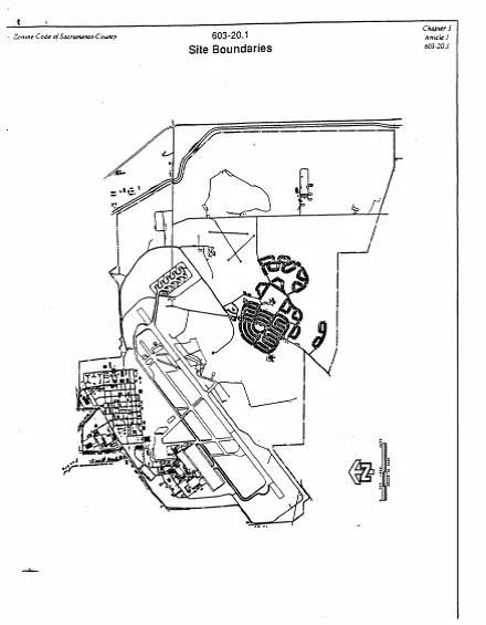
603-20.2 Land Use Districts and Subareas Prior to September 13, 2016.
Section titled “603-20.2 Land Use Districts and Subareas Prior to September 13, 2016.”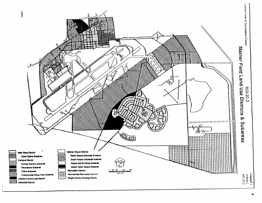
603-20.2.5 Land Use Districts as of September 13, 2016.
Section titled “603-20.2.5 Land Use Districts as of September 13, 2016.”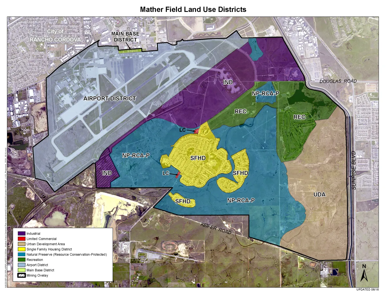
603-20.3 The Single Family Housing District
Section titled “603-20.3 The Single Family Housing District”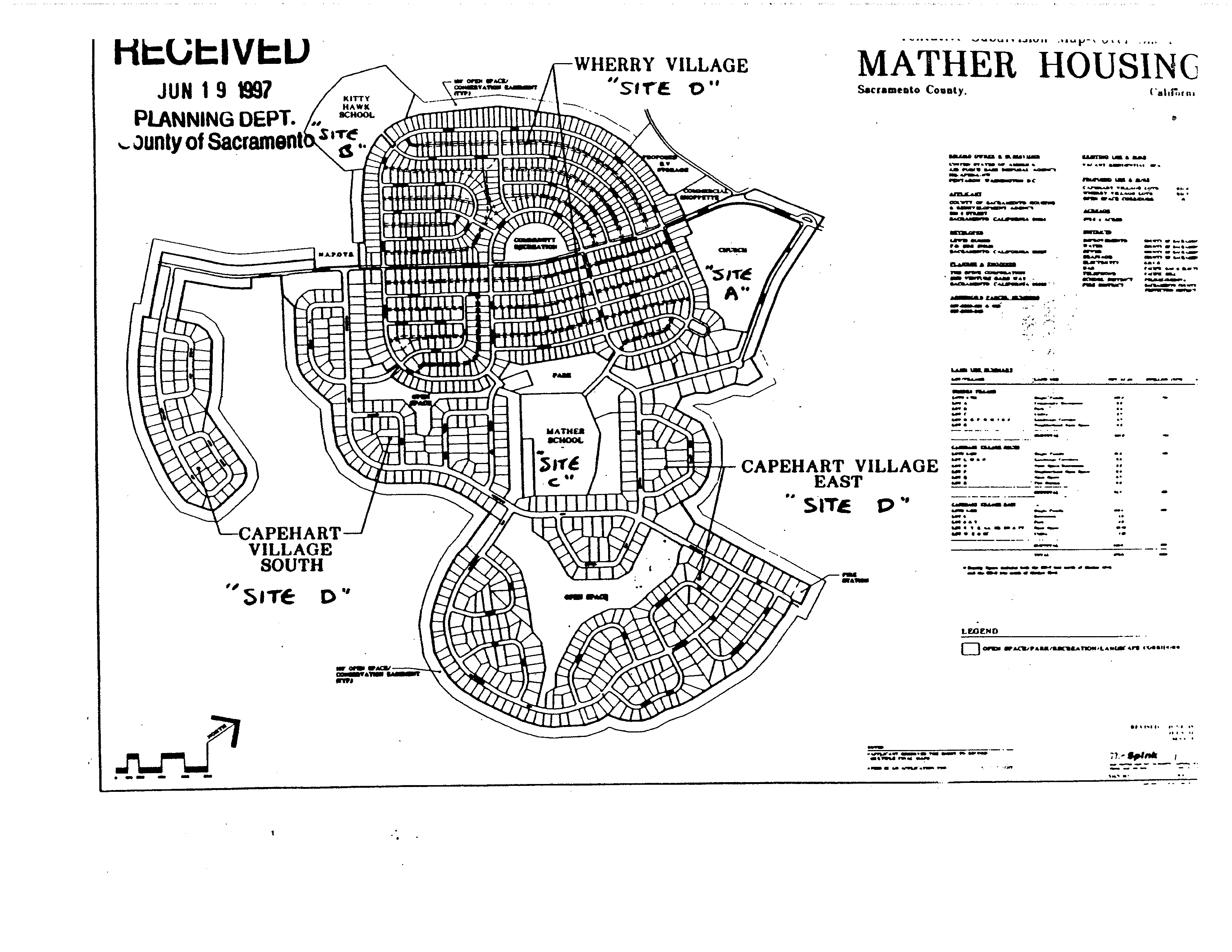
603-20.3.5 Housing Area Fence Detail
Section titled “603-20.3.5 Housing Area Fence Detail”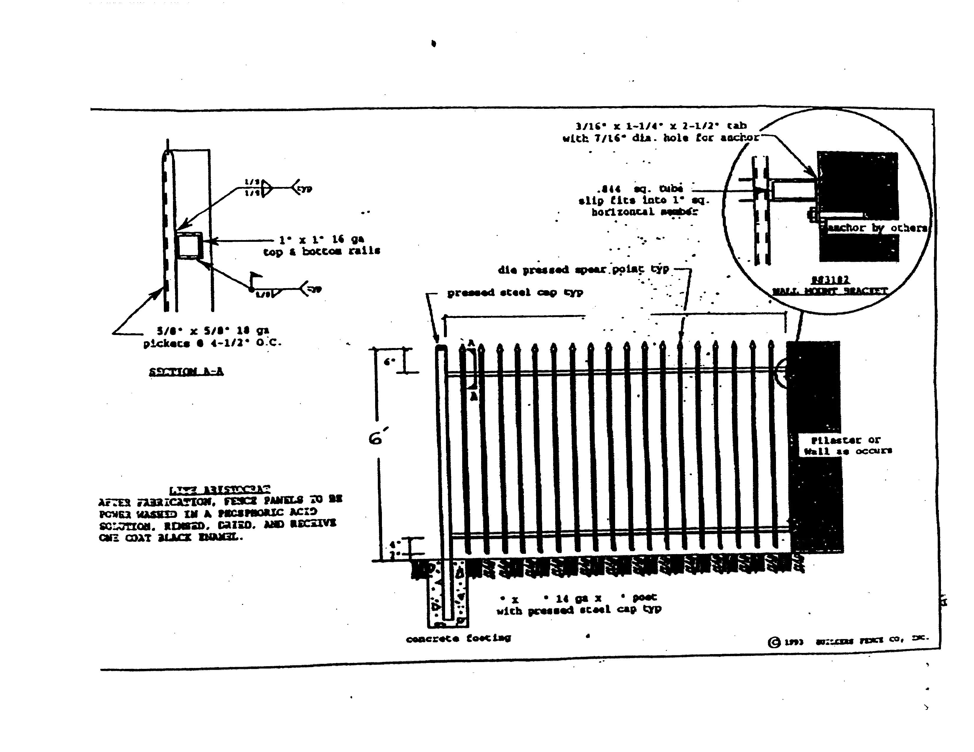
603-20.3.6 Mather South Environmental Education Campus Concept Plan
Section titled “603-20.3.6 Mather South Environmental Education Campus Concept Plan”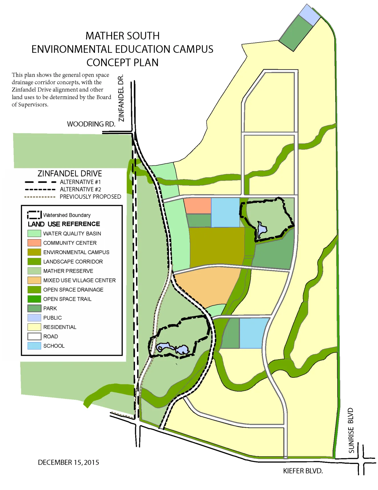
603-20.4 Mather Field SPA - Design Review Area
Section titled “603-20.4 Mather Field SPA - Design Review Area”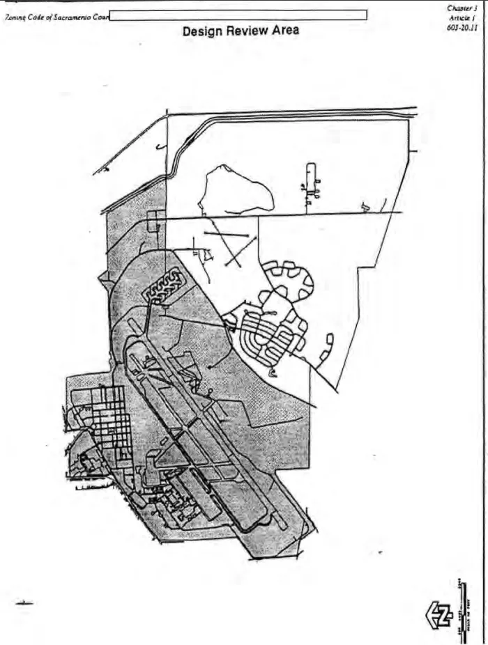
603-20.5 Mather Field SPA - Design Guidelines
Section titled “603-20.5 Mather Field SPA - Design Guidelines”Introduction
Section titled “Introduction”For more than 70 years, the 5,700 acres within Mather Field have been set aside under single federal ownership, operating relatively independently of the surrounding community. As Mather sheds its military trappings, the challenge will be to reintegrate the facility within the community and create a new civilian identity for Mather Field. The purpose of these guidelines is to create a framework for existing and new development that will help to:
-
Create an attractive setting that can assist in marketing new uses and activities.
-
Establish an identity that is clear and coherent but, at the same time, can be adaptable to changes as development occurs over time.
-
Provide a framework for development that is unified and coordinated in appearance, but which allows for a diversity of uses and users, as well as different districts.
-
Strengthen linkages to the surrounding community and the larger landscape, and enhance the sense of place.
Overview
Section titled “Overview”The Mather Field design guidelines are intended to address those elements that most directly affect the character of the place as it transitions from military to civilian use over an extended period of time. In general, the approach that is reflected in these guidelines recognizes the relatively limited role of buildings to shape the environment, considering that some may or may not be reused and many others will be built. Guidelines are set forth for color, materials, and wall and window treatment, recognizing that in some areas, such as the Main Base, buildings will have a more significant impact on the image of Mather. In other areas, however, the approach taken toward buildings does not focus on the design of buildings to carry forth a new image and identity for Mather Field. Rather, the greater emphasis is placed on the landscape to transform and provide structure to the environment. New landscaped roads and open spaces will provide shade and amenity to the environment, create stronger and more attractive entries, weave the developed areas into a broader pattern with the surrounding grasslands, and link the larger Mather Field with the Rancho Cordova community.
Due to the incorporation of the City of Rancho Cordova in 2003, a portion of the area referenced in these Design Guidelines is no longer within the jurisdiction of the County of Sacramento. However, the City of Rancho Cordova has adopted the Mather Field Special Planning Area and Specific Plan as part of its City Ordinances. As such, the guidelines in this section have been left as is for those areas, regardless of current jurisdiction, to provide context for development contemplated within County-controlled areas of the Plan. Removal of subareas and creation of new Districts within the SPA Ordinance are reflected in the Design Guidelines.
More specifically, the general guidelines for Mather Field as a whole are intended to address the following:
Landscape Framework. Landscaping of streets and open space will be used to provide amenity, organize the site, and unify disparate uses and activities. Along streets, trees will be planted along the curb in a parkway strip, with large deciduous trees placed 24 to 40 feet on center. On individual parcels, all areas not covered by structures or used for parking and circulation should be planted with trees, shrubs, turf (in special areas) and/or groundcovers. All landscape areas should be provided with a complete automatic irrigation system to establish new planting and, as a guideline, a minimum 24-inch box size is recommended for all new trees. In areas where mature trees are established, 15-gallon (minimum) trees may be planted.
The landscape focus of the base will be the entry open space in the Main Base Area, which will be designed as a shaded park with active playfields and community buildings. Materials such as stone, ceramic tile or bronze are encouraged to give a human scale within the pedestrian realm. Extensive use of wood composites or thin weather-resistant skin over nondurable backing and other nondurable materials should be avoided. Awnings, belt courses, transom windows and/or moldings are encouraged to provide visual relief and to clearly articulate the building base from the upper level portions of the building. The use of mirrored and/or reflective glass and glass curtain walls is discouraged. Colors should be light and coordinated to achieve continuity of design. Fenestration of all buildings should employ a "punctured" wall treatment with high quality window casings that are recessed from the building face to provide shade and detail. Service and loading areas should be designed as an integral part of the structures, and should not be oriented to any public right-of-way or open space amenity. All exterior garbage and refuse facilities and mechanical equipment should also be screened from public view in a manner that is compatible with the overall building design. Roofmounted mechanical equipment should be concealed from view.
Signage. Like landscaping, signs are an important element contributing to the identity of Mather. All signage should be consistent in character and express a sense of hierarchy. In addition, all signs should be compatible in design, size, proportion, color and materials with the architecture they serve. Signs visible from the exterior of any building may be lighted, although no canned or backlit signs will be permitted, and no signs or any other contrivances may be devised or constructed so as to rotate, gyrate, blink, flash, or move in any fashion. Only one permanent sign should be permitted per parcel front age. Ground signs should not exceed four feet in height above grade nor 56 square feet in area. If signs are placed upon landscaped berms, their maximum height above the road should be no more than six feet. Signs placed on streetside berms should not be located within vehicular sight distance zones for intersections and entry drives. All signs attached to buildings should be surface mounted. Building address numbers should be displayed as close as possible to the main entrance lobby, and numerals should always face the street or pedestrian approach. No general or advertising signs will be allowed.
Fencing, Walls and Hedges. Although it is recognized that fencing will be required for security in some areas (in particular, surrounding the airfield), fencing should be discouraged to the extent feasible between parcels and kept as low as possible, generally no higher than six feet. Walls should also be kept as low as possible, no higher than six feet. Perimeter fencing, where necessary, should be planted with vines or concealed from view by plantings. Where a more open fencing is desired around the airfield, plastic-coated chain link fencing of dark colors should be encouraged. Fencing is discouraged altogether in the Main Base.
Lighting. All exterior lighting should comply with the requirements of the FAA. It should be shielded and confined within site boundaries and no direct rays or glare is permitted to shine onto public streets or adjacent lots. Security lighting should be restricted to service areas and may not be substituted for parking lot or pedestrian circulation lighting. High-pressure sodium vapor lighting should be used for the best representation of natural colors.
Parking Areas. Parking areas should be well landscaped to moderate the effects of the climate. Tree planting should be planned to achieve 50 percent coverage in 15 years. A minimum of three-inch caliper trees should be planted. The use of drought-tolerant and disease-resistant native plant materials is encouraged. Planting areas should be protected from cars by incorporating a six-inch raised curb around the planting area. Driveways should be limited to generally no more than two per parking area, and curb cuts should be minimized in length so as not to interrupt the continuity of street tree landscaping. Pedestrian-scale lighting should be utilized in parking areas. Light standards should be 16 to 18 feet in height.
Design Districts
Section titled “Design Districts”Figure 10 - Design Districts
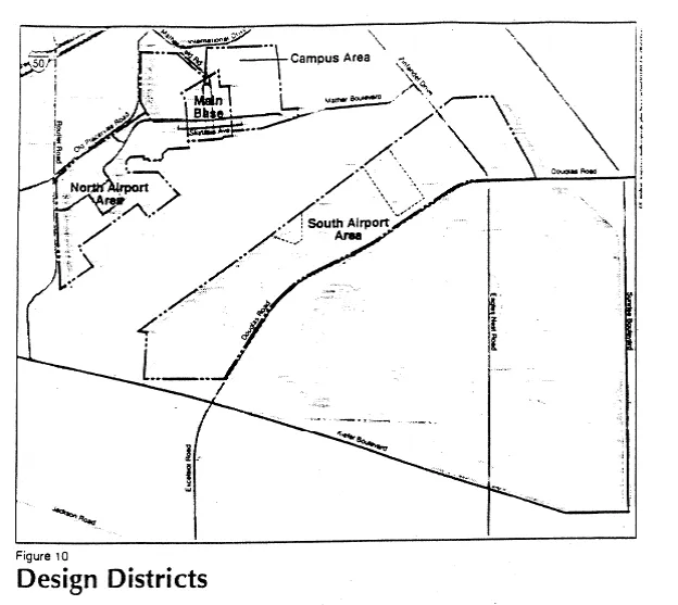
For purposes of developing more specific design guidelines, Mather Field has been divided into four basic districts. As identified in Figure 10, these include:
-
The Main Base Area. which constitutes the urbanized core of Mather Field. The majority of this area is located in the City of Rancho Cordova. It is included for context;
-
The Campus Area, which surrounds the Main Base. This area is located in the City of Rancho Cordova. It is included for context;
-
The North Airport Industrial Area, which includes the cluster of airport-oriented uses served from Routier Road and Old Placerville Road; and
-
The South Airport Area,which encompasses the undeveloped airport-oriented area to the north of Douglas Road.
These areas are defined by similar characteristics: use, location, relationships and access. These guidelines specifically exclude the commercial recreational area, the residential neighborhood, golf course, open spaces, and the airport itself.
The Main Base
Section titled “The Main Base”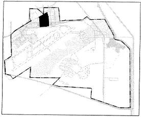
Overall District Role and Character
Section titled “Overall District Role and Character”The Main Base represents the core of the Mather complex. It is situated at the heart of the most developed area and at the gateway to the airfield and adjacent support areas. With direct access from the freeway off Mather Field Road, this portion of the property is more immediately visible and accessible, both within the region and to the adjacent Rancho Cordova community.
The Main Base is the most compact area, and is characterized by a relatively small-scale grid of streets and blocks that creates a village-like environment. It is anticipated that it will be maintained as the major activity center of Mather Field, and will be developed as a center of business, culture, recreation and shopping that will support the planned aviation uses and, at the same time, complement the adjacent community. A number of buildings have been identified as likely to remain or as suitable for interim and future reuse. Currently, the green between Whitehead and Von Karman creates a strong entry feature to Mather Field.
The following topics address design issues and set forth guidelines that are intended to build upon the role of the Main Base as the gateway and activity center of the Mather Field complex:
Entry Open Space
Section titled “Entry Open Space”-
The existing landscaped green between Von Karman and Whitehead Streets should be reinforced and improved as public open space by development along the edge; by landscape improvements at the entry and along the greenp; by recreational improvements and pedestrian amenities within; and by the placement of the airport terminal at the southerly end (see Figure 11). The gateway open space is envisioned as a landscaped amenity and feature that helps to organize and orient the surrounding Main Base uses, and it can be used as a public gathering space for the development. It should also create opportunities for recreation, social gathering and civic/cultural activities.
-
The entry circle should be planted in a manner that reinforces the circular form, incorporating a landmark or vertical element to provide a sense of focus and arrival and a welcoming feature at the primary gateway into Mather Field. The current vehicular access to the Administration Building should be closed and pedestrian access from the street emphasized. An evergreen frame of shade trees should be considered, along with more vertical deciduous trees within the center of the circle for both contrast and diversity.
-
Continuous street tree planting should be provided on both sides of the entry streets (Von Karman and Whitehead) within a parkway strip, with trees planted on average 24 to 40 feet on center, and of a consistent species in a memorable pattern for both shade and color. Recommended species are noted in Figure 12.
-
Landscape material, including grasses, should be drought tolerant. Turf is allowed under special circumstances, namely within the central green and parkway strips.
-
Corner radii should be limited to the extent feasible, to encourage pedestrian movement and to reduce the perceived scale of streets. Curb radii should match to create a well-balanced intersection.
-
The military gates should be removed and the entry island landscaped with special plantings that mark the entry to Mather Field. Signage for orientation and direction should be located within the island to provide an overview of facilities and their general location within the development.
-
Buildings within the landscaped linear green will be limited, and they should have a strong civic presence and public orientation. Entries should be oriented to the green, and the green should be designed to receive “spillover" activities from the buildings that take advantage of the open space setting and the opportunity for special events and festivities. No new buildings will be allowed within the green.
-
Each of the blocks should include a continuity of landscape materials and elements, but individuality within each block should also be encouraged.
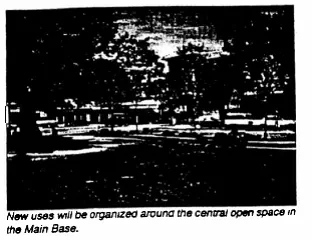
-
Within the Main Base and specifically along Von Karman and Whitehead Streets, buildings should orient to the open space. Curb cuts to adjacent parcels should be limited to the minimum necessary in order to provide for a continuity of landscape and pedestrian treatment. Although the open space will be crossed by streets, the cross sections of these streets should be minimized, and their treatment should be park-like in character.
-
Visual continuity from the north to the south should be emphasized, and views and visual access should be enhanced to the industrial park, the airport, and the planned airport terminal building.
-
The airport terminal building should be of the highest design quality, and should be designed to become the landmark signaling the edge of the airport and the end of the entry access corridor and landscaped green.
Figure 11- Design Framework- Main Base
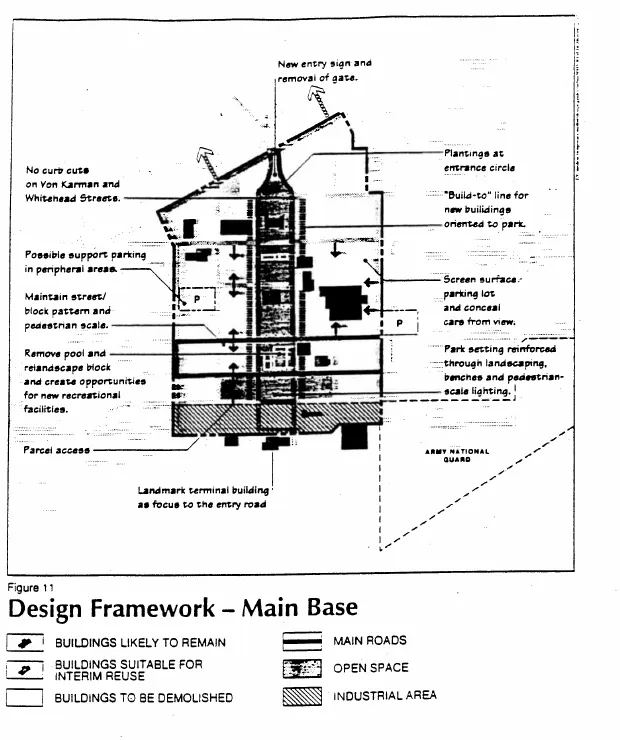
Parcelization and Parking
Section titled “Parcelization and Parking”-
The fine-grained fabric of the Main Base is one of its most appealing qualities, and should be maintained through parcelization patterns that enhance the sense of a pedestrian-oriented village. More specifically, the existing block dimensions should be retained; aggregation of parcels into superblocks beyond the existing block pattern should be discouraged.
-
Parking within the Main Base should be provided in such a fashion that it does not visually dominate the parcels and the blocks and thus diminish the pedestrian orientation and village character of the area.
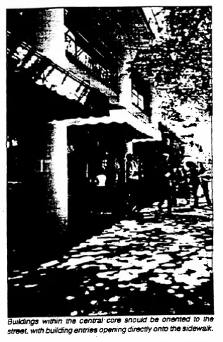
-
Parking standards should generally comply with the County of Sacramento Zoning Code; however, the full off-street parking requirement need not be accommodated onsite. A portion of the required parking for the central core could be located within a remote parking lot(s) located on the periphery of the Main Base core (see the Main Base Design Framework Map).Opportunities for shared parking between parcels and uses should be encouraged.
-
No new surface parking should be permitted within the central green, and existing parking areas should be relandscaped so they do not visually dominate what should become a park-like setting.
-
Surface parking should be oriented away from streets and pedestrian areas, and screened from predominant view by buildings, landscaping and low walls. Parking areas should be distributed throughout the area rather than concentrated into large lots, if feasible. Parking areas should avoid fronting on Von Karman and Whitehead Streets, and access should be limited, to the extent possible, along Mather Boulevard and Norden Avenue.
-
Parking areas should be shared between uses and located so as to minimize curb cuts. In general, curb cuts and driveways should meet County standards. Driveways should be a minimum of 50 feet from the nearest intersection. No more than 150 parking spaces should be served from a single driveway or parking access point. Parking areas should have no more than two access points, and entryways should be minimized in width.
-
On-street parking should be permitted where allowed by existing street rights-of-way.
Building Orientation
Section titled “Building Orientation”-
Buildings within the central core should be oriented to the main streets--that is, Whitehead and Von Karman. Along these streets, buildings should be built to the property line, so that building entries open directly onto the sidewalk; curb cuts should be prohibited (if allowed by parcelization) to provide for a continuity of landscaping along these streets.
-
Uninterrupted and untreated blank walls and surface parking areas should be discouraged along the open space frontage (Von Karman and Whitehead Streets). If a large user (e.g., office or large retailer) is established along this frontage, the building siting should orient storefronts and entries along Von Karman and Whitehead Streets. Frequent pedestrian entries should be encouraged along these streets. To the extent practical, such entries should be located within 50 feet of one another to avoid long expanses of inactive frontage.
Building Height, Bulk and Configuration
Section titled “Building Height, Bulk and Configuration”-
Dramatic contrasts in building height and bulk should be avoided, and buildings should be kept relatively low in scale (no more than 40 feet in height).
-
Buildings over two stories should incorporate setbacks to address building mass and bulk. Buildings should have a maximum streetwall height of 40 feet. Buildings above this height should be stepped back by approximately five feet for a minimum of 50 percent of the frontage and be accompanied by architectural expression (e.g., loggia, balcony, cornice, sloping roof, etc.).
Signage, Fencing, Walls and Hedges
Section titled “Signage, Fencing, Walls and Hedges”-
The Main Base Area should emphasize an open character, with a close relationship between buildings and the street. Fencing should be strongly discouraged between parcels. Rather, landscaped berms and short walls (no greater than 24 inches) should be encouraged to screen parking areas from the street
-
In the Main Base Area, signage should be oriented to the pedestrian in terms of size, location, lettering and lighting. Awnings and window signs are encouraged to provide variety along the street. Retail signs shall not be located above the ground floor building eave or first story plate line. All signs should meet the standards described on page 38 in the Design Guidelines section of this SPA.
-
Freestanding signs should be limited to retail users.
-
A system of directional and orientation signs should be established to provide direction to the FBO Terminal and other significant base destinations (i.e., cargo handling area, maintenance area, etc.). Directory signage should not use company names, such as “Federal Express," but rather “air cargo area". Specific business names and signage should be placed on buildings.
Streets
Section titled “Streets”-
Streets within the Main Base should be developed as gracious tree-lined corridors.
-
To encourage bicycle movement, bike lanes are provided for throughout Mather Field on designated streets (see Circulation chapter). The typical street sections for Whitehead and Von Karman and Stratotanker and Skytrain Avenues are illustrated in Figure 12.
-
Shade trees should be consistently planted throughout the Main Base streets at 24 to 40 feet on center within a minimum six-foot planting strip on the curb side of the sidewalk. A double row of trees should be planted along the central green.
-
Large shade trees (e.g., native sycamore, London Plane trees, maples, hackberry) should be used to provide amenity and protection from the elements.
-
Curb cuts should be limited to one per frontage for standard blocks, and two per frontage for larger blocks.
-
Light standards that are pedestrian scale (no greater than 16 to 18 feet in height) and compatible in design with the character of the area are encouraged. New light standards will be included as part of the street and landscape improvements implemented as part of the EDA grant on the Main Base couplets. New light standards on the remaining streets should also use these standards for consistency within the district.
-
Suitable longitudinal root barriers should be installed in conjunction with new tree planting adjacent to curbs and sidewalks.
Figure 12- Cross Sections- Main Base Couplets
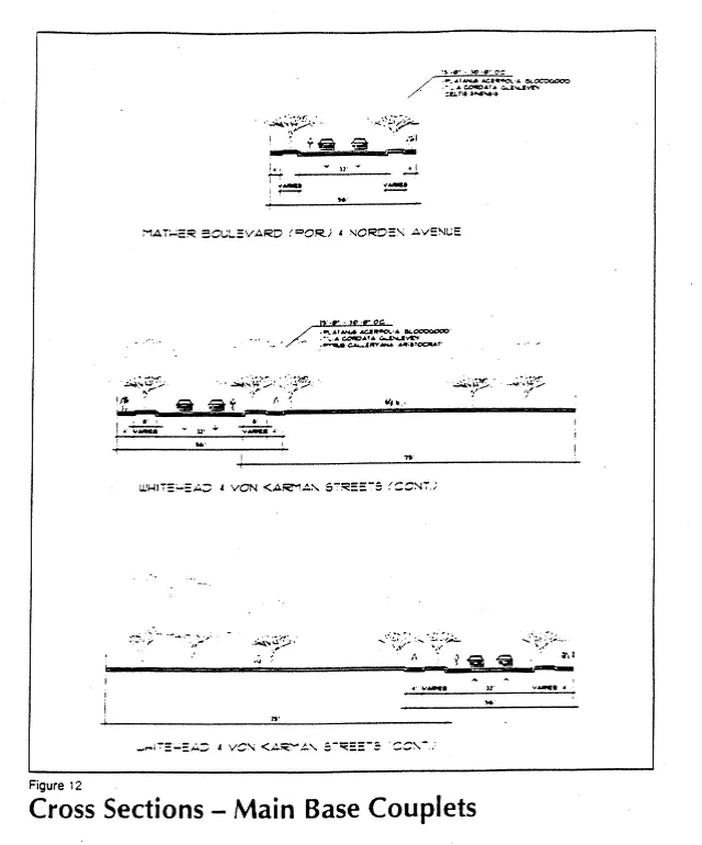
Campus Area
Section titled “Campus Area”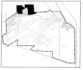
Overall District Role and Character
Section titled “Overall District Role and Character”The Campus Area surrounds the central core of the Main Base, and is planned for a wide range of educational, recreational, commercial and institutional uses. This area will be developed as a campus that utilizes large open space areas to unify the various entities. The Campus Area will be home to large users and a major community park, and will be composed of existing as well as new buildings. A number of design guidelines have been developed to create a high quality landscaped image that can unify and create a cohesive development (see Figure 13):
Figure 13- Design Framework- Campus Area
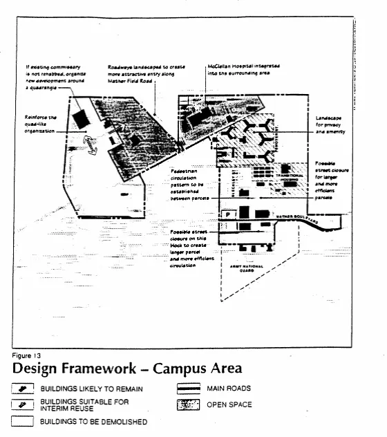
Entry Road
Section titled “Entry Road”- Mather Field Road should be well landscaped, with trees planted 25 feet on center on both sides of the street to mark the arrival at the facility, create a positive and attractive appearance, and extend the entry sequence into the base.
Landscape Setbacks
Section titled “Landscape Setbacks”-
New development should incorporate generous landscaped setback areas between the street and parking areas. As a guideline, a 25-foot minimum landscaped setback should be provided adjacent to all streets.
-
Landscaping within the setback area could incorporate berms (no higher than three feet) and/or walls (no greater than 24 inches) that screen parking areas from view. The setback areas should include at least two rows of shade trees as well as groundcover and shrubbery, as appropriate. Pedestrian pathways should also be included, to connect parcels with one another.
Parcelization and Parking
Section titled “Parcelization and Parking”-
The Campus Area should be composed of larger parcels that can accommodate large institutional and R&D users. Buildings should be encouraged to create open spaces that are related to one another. Minor roads within the area, (i.e., south of the McKinney housing area) should be eliminated, where possible, to create larger, more efficient parcels and to create opportunities for more innovative site planning and campus design.
-
To the extent possible, parking areas should be concentrated away from building complexes, so as to create a more park-like and pedestrian character within the parcel.
-
An “orchard" planting consisting of trees in tight rows, or as part of a larger open space pattern, is encouraged in surface parking areas.
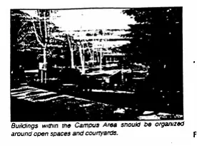
Building Orientation and Organization
Section titled “Building Orientation and Organization”-
Buildings should be organized within clusters around open spaces linked by walks and pathways. Major entryways and public functions should be oriented to the open space and interconnected with pathways that link from parcel to parcel and weave the entire district together. Buildings should express the entryways through windows, primary doorways and landscape treatment.
-
To the extent feasible, people-oriented activities such as administrative offices should be located toward the internal open space. Loading and storage areas should be located toward the interior of the site and screened from view by buildings, if possible.
-
Buildings and clusters of buildings should be organized around open spaces and linked to one another. Pathways and pedestrian easements should provide access between parcels and should be tied to the system and organizational structure provided by streets and open spaces.
-
New and existing groups of buildings should be configured to reinforce or create quadrangle and courtyard areas between buildings. Within the open space areas, special plantings, fountains, benches, and other amenities should be encouraged in order to create usable places to sit, socialize and gather.
Fencing, Walls and Hedges
Section titled “Fencing, Walls and Hedges”- Fencing should be discouraged between parcels and buildings to the extent feasible (except around the transitional housing), to maximize the amenity of the campus open space areas.
Landscaping
Section titled “Landscaping”-
A landscape master plan should be prepared for each of the parcels within the Campus Area, and should be an intrinsic part of the overall site planning for each parcel. The master plan should address not only onsite issues, but also establish pedestrian pathways between buildings within the Campus and the park, between the Campus and the Main Base Area and internal connections between Campus buildings. Landscape plans should be reviewed as part of the design review process (described in the Implementation chapter).
-
The master plan should also specify a planting palette, specifying trees, shrubs and groundcover to be used in the area, and planting specifications.
Figure 14-Cross Section - Femoyer Street
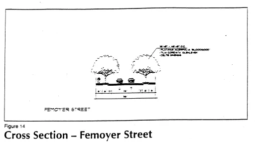
- Several parcels on the east side of the base are being used for McKinney Act housing. These areas should be well landscaped for privacy and amenity.
Employee Eating Areas
Section titled “Employee Eating Areas”- Outdoor eating areas for employees should be encouraged for all new institutional and office buildings containing more than 5,000 square feet and located more than 1,000 feet from the park. As a guideline, a minimum of 300 square feet of outdoor space shall be provided for every 5,000 square feet of building area.
Streets
Section titled “Streets”-
Streets within the Campus Area should provide a continuation of the surrounding landscape and use large shade trees planted in a regular configuration to accent movement corridors.
-
Bicycles should be accommodated within the street system, as diagrammed in the circulation plan. The typical street section for Femoyer Street is diagrammed in Figure 14.
-
Light standards which are pedestrian in scale (no greater than 16 to 18 feet in height) and compatible in design with the character of the area are encouraged. New light standards will be included as part of the street and landscape improvements implemented as part of the EDA grant on the Main Base couplets. New light standards on the remaining streets should also use these standards for consistency within the district.
-
Large shade trees should be consistently planted along roads at 40 feet on center within a minimum6-foot planting strip on the curb side of the sidewalk.
-
Large shade trees (e.g., native sycamores, oaks, elms) should be used to provide amenity and protection from the elements.
North Airport Industrial Area
Section titled “North Airport Industrial Area”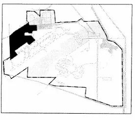
Overall District Role and Character
Section titled “Overall District Role and Character”The North Airport Industrial Area contains many of the hangars, maintenance and support buildings that are associated with the airfield. Air cargo operations will be concentrated in this area and it will continue to have a strong orientation to aviation and related activities, and will utilize many of the existing buildings and facilities. The intent in this area is to emphasize the functional industrial nature of the place through honesty in building types, completion of a logical service road system, organization of uses within the district, and institution of property maintenance requirements. As many buildings will be reused and rehabilitated, emphasis will be placed on providing facade improvements to ameliorate the appearance of the area. Since Macready Avenue will be the principal truck entry for air cargo uses, landscaping should be used to create a strong entry as well as to screen existing fuel farm activities (see Figure 15).
Figure 15- Design Framework- North Airport Area
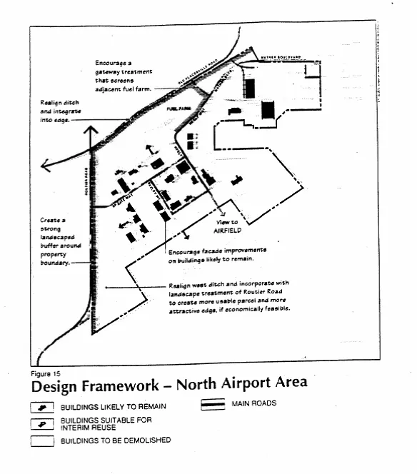
Landscape and Facade Improvements
Section titled “Landscape and Facade Improvements”-
Improvements to building frontages should be provided as buildings are reused. At a minimum, new paint, awnings and/or building entrance improvements should be encouraged, as well as landscaping where possible.
-
Landscaping on private parcels should include trees as well as shrubbery and groundcover that has function in providing shade and protecting against erosion.
-
If economically feasible, the west drainage ditch should be realigned to the edge of the parcels and incorporated into a landscaped treatment along Old Placerville and Routier Roads to encourage more efficient use of the property as well as to establish a more attractive edge.
Industrial Character and the Visibility of Activities
Section titled “Industrial Character and the Visibility of Activities”-
For new development, architectural treatment should be expressive of service and industrial activities and provide visual interest to users and visitors to the area, to the extent possible. Consideration should be given to the introduction of significant window openings that reveal indoor activities and machinery within buildings. Similarly, architectural expression of major functional or structural elements should be considered to create a more interesting building silhouette and elevation. Portions of buildings adjacent to streets should be treated with particular care to ensure visual interest and a compatible scale and streetscape relationship.
-
View corridors directly into the airfield should be maintained.
-
Buildings should employ durable, high quality materials appropriate to the functions and requirements of the planned activities. Innovative use of standard materials (e.g., corrugated metal, steel and masonry) and large metal sash window openings is encouraged.
Streets
Section titled “Streets”-
Macready Avenue at Old Placerville Road will serve as the primary entry street to the North Airport area. This street (planned for improvement as part of the EDA grant roadway project) is considered a two-lane collector. The existing pavement width, at Old Placerville is wider than assumed in the typical Mather standard, shown in Figure 24 of the Specific Plan Circulation Section. This entrance should incorporate not only sidewalks, as shown in the cross section, but also an on-street bikeway linking bikeways on Mather Boulevard and Neely Way with Old Placerville Road.
-
Sidewalks should be provided adjacent to streets throughout the North Airport [I]
industrial area.
South Airport Area
Section titled “South Airport Area”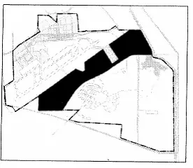
Figure 16- Design Framework - South Airport Area
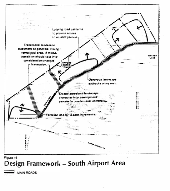
Overall District Role and Character
Section titled “Overall District Role and Character”The area south of the airport contains both large areas for new airport-related development and areas for open space preservation and managed extraction of mineral resources. In this area, the design objectives include extending the surrounding California grassland landscape into the development parcels to avoid an abrupt transition between manicured and natural landscape elements. The area with the highest concentration of vernal pools may be maintained in open space, and landscape buffers and transitions between the new development and this parcel will be provided as appropriate. Douglas Road, which will provide a boundary between the South Airport commercial and industrial development and the open space and residential area, should be developed as a boulevard which incorporates a native plant palette emphasizing stately trees, such as oaks and native sycamores, to create a high quality image for the area (see Figure 16).
Parcelization
Section titled “Parcelization”-
Parcels in the South Airport Area are planned to be large, to allow flexibility for potential users. It is anticipated that these will be subdivided into smaller 10 to12-acre parcels. As this occurs, roadways should be extended to connect parcels and to provide access.
-
Roadways throughout the area should be encouraged to serve larger areas in order to help create a more cohesive district, and to help reduce local traffic congestion.
Landscape Character
Section titled “Landscape Character”-
The landscape character of the South Airport Area should draw from the open and expansive qualities of the surrounding grasslands, with a predominant planting of grasses with oaks and other native trees.
-
Buffers should be maintained, with a minimum average width of 40 feet adjacent to natural areas and a transitional planting palette established, so that sharp boundaries between developed and undeveloped areas are not reinforced through landscape treatments.
-
Porous pavement treatments and storm water basins should be incorporated into the planting plan for the area, utilizing meaningful approaches to ecological design and creating opportunities for diversity and interest.
-
Irrigation should be installed to establish landscaping, but not to support a water-consumptive planting scheme.
Figure 17- Cross Section- Douglas Road
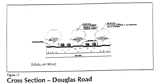
Streets
Section titled “Streets”-
Douglas Road will be developed as an important connecting boulevard that will provide a transition between uses as well as landscape amenity and the image for the area. The design concepts for the street are diagrammed in Figure 1 7. Douglas Road will be a four-lane street with a strong landscape character derived from a planted median and curbside landscape strip. Stately native trees that reference the surrounding landscape, such as oaks and native sycamores are recommended.
-
Large trees should be planted within the median and in planting strips in a regular configuration at 40 feet on center. Native and/or drought-tolerant species such as oak, madrone, sycamore and alder should be encouraged, as well as groundcover composed of native grasses and wildflowers.
603-20.6 Mather Field SPA - Development Standards
Section titled “603-20.6 Mather Field SPA - Development Standards”TABLE 1 - SPA ZONING CATEGORIES (MAIN BASE, OPEN SPACE, LIMITED COMMERCIAL)
Section titled “TABLE 1 - SPA ZONING CATEGORIES (MAIN BASE, OPEN SPACE, LIMITED COMMERCIAL)”| Standard | Main Base District | Open Space Subarea | Limited Commercial District |
|---|---|---|---|
| Underlying zone | Shopping Center (SC), Business and Professional Office (BP), Industrial Office Park (MP) | Open Space (O) zone | Limited Commercial (LC) zone |
| Permitted uses | Commercial, office, and residential uses. | Open space and passive recreational uses, and existing buildings. | Those uses permitted in the LC zone as listed in Section 225-41. |
| Appeals or exceptions | All deviations to the Development Standards shall be subject to the Mather Design Review Process. Use permits and variances shall be processed according to adopted zoning code standards. | All deviations to the Development Standards shall be subject to the Mather Design Review Process. Use permits and variances shall be processed according to adopted zoning code standards. | All deviations to the Development Standards shall be subject to the Mather Design Review Process. Use permits and variances shall be processed according to adopted zoning code standards. |
| Existing structures | All existing structures shall be considered legal nonconforming. | All existing structures shall be considered legal nonconforming. | All existing structures shall be considered legal nonconforming. |
| Height | General height standards, Section 301-20 through 301-25 and the Commercial Development Standards, Section 315-44 except Section 315-44(c) shall have a maximum height limit of 65 feet. Deviations related to height standards and restrictions shall be made in accordance with the Mather Design Review process. …if contiguous to a residential parcel, structures or buildings may not exceed 24 feet in height. All other parcels may have structures and buildings erected to a height not to exceed 65 feet …exceptions may be allowed to a 150-foot maximum, however, cannot exceed 2.5 FAR as provided in Section 301-22. |
General height standards, Section 301-20 through 301-25 and the Commercial Development Standards, Section 315-44. Deviations related to height standards and restrictions shall be made in accordance with the Mather Design Review process. … if contiguous to a residential parcel, structures or buildings may not exceed 24 feet in height. All other parcels … may have structures and buildings erected to a height not to exceed 40 feet … exceptions may be allowed to a 150-foot maximum, however, cannot exceed 2.5 FAR as provided in Section 301-22. |
General height standards, Section 301-20 through 301-25 and the Commercial Development Standards, Section 315-44. Deviations related to height standards and restrictions shall be made in accordance with the Mather Design Review process. …if contiguous to a residential parcel, structures or buildings may not exceed 24 feet in height. All other parcels … may have structures and buildings erected to a height not to exceed 40 feet …exceptions may be allowed to a 150-foot maximum, however, cannot exceed 2.5 FAR as provided in Section 301-22. |
| Lot size | No minimum w/ water & sewer per commercial standards. | No minimum w/ water & sewer per commercial standards. | No minimum w/ water & sewer per commercial standards. |
| Lot frontage, width & depth | Each lot shall have at least 50 feet of public or private street frontage and lot width and adequate building area to serve the intended use. (New standard written to encourage frontage on streets in the main base subarea.) | No minimums required. | LC Standards, Section 225-42 Individual lot frontage on a public street is not required; however, lots shall have sufficient width & depth to maintain yard areas & adequate building area to serve the intended uses. |
| Setbacks: Front & side street yards | Along all streets in the main base subarea, setbacks may vary between 13 feet and 25 feet. A minimum side street yard setback of 13 feet is required; however, no maximum side street yard setback is required. Setbacks are measured from the back of the public street right-of-way. New off-street parking areas must be set back a minimum of 50 feet from Whitehead and Ecknes Streets, unless lot depth is less than 50 feet. (Parking requirement is proposed to encourage frontage of buildings along Whitehead and Eknes as no other use is allowed.) |
Commercial Standards, Section 315-42(b). There shall be a front and side street yard of at least 50 feet between any structure or use … and the public street right-of-way. Such yard may be reduced to a minimum of 25 feet provided that for each square foot of additional buildable area created …, an equivalent area of planter or landscaped area is provided in the corresponding front or side street yard. Such planter or landscaped areas shall be in addition to the planter and landscaped areas required in Section 315-45 of this Article and shall be subject to all the provisions of this Section. |
Commercial Standards, Section 315-42(b) There shall be a front and side street yard of at least 50 feet between any structure or use … and the public street right-of-way. Such yard may be reduced to a minimum of 25 feet provided that for each square foot of additional buildable area created …, an equivalent area of planter or landscaped area is provided in the corresponding front or side street yard. Such planter or landscaped areas shall be in addition to the planter and landscaped areas required in Section 315-45 of this Article and shall be subject to all the provisions of this Section. |
| Setbacks: Rear yard & interior side yard | Commercial Standards, Section 315-43(b, c, d, e, & f) There shall be a rear yard and an interior side yard of at least 25 feet between any structure … and the boundary line of any adjacent residential, … recreation, agricultural, or agricultural-residential … zone; otherwise a rear or interior side yard is not required. Exceptions allowed including for mechanical equipment. |
Commercial Standards, Section 315-43(b, c, d, e, & f) There shall be a rear yard and an interior side yard of at least 25 feet between any structure … and the boundary line of any adjacent residential, … recreation, agricultural, or agricultural-residential … zone; otherwise a rear or interior side yard is not required. Exceptions allowed including for mechanical equipment. |
Commercial Standards, Section 315-43(b, c, d, e, & f) There shall be a rear yard and an interior side yard of at least 25 feet between any structure … and the boundary line of any adjacent residential, … recreation, agricultural, or agricultural-residential … zone; otherwise a rear or interior side yard is not required. Exceptions allowed including for mechanical equipment. |
| Landscaping | Commercial Standards, Section 315-45 all other commercial zones The 5-foot wide planter or landscaped area may be within the street right-of-way between the edge of the street and the sidewalk. Landscaping shall be installed in the street right-of-way from the back of curb, excluding the sidewalk. Trees must be planted no further apart than 25 feet on center. Delete requirement to increase planter size to 8 feet for at least 7 feet of every 50 feet of frontage along street rights-of-way. No curbing is required to bound the planter. A planter or landscaped area is required 5 feet wide adjacent to all street rights-of-way, excluding approved driveway entrances. Any area within the street right-of-way between the edge of the sidewalk and outer edge of the right-of-way shall be developed as a planter or landscaped area in conjunction with the 5 feet area above. Trees shall be planted no further apart than 50 feet on center, at least 5 feet but no further than 10 feet from the back of the sidewalk. The planter shall be bounded by a curb at least 6 inches high, & shall include shrubs, hedges, and other natural growth, or other features such as berms designed to form a partial visual screen at least 3 feet in height. Landscaping near street & driveway intersections shall not exceed 2.5 feet in height. |
Institutional Standards, Section 320-05 The 25-foot landscape area shall be measured from the edge of the street pavement. Sidewalks may be included within the setback area. Landscaping shall be installed in the street right-of-way from the back of curb, excluding the sidewalk. If approved by the Community Development Director, or his designee, a portion of the required 25-foot landscape corridor may be within the public street right-of-way. The requirement for landscaping forming a visual screen shall not apply. A planter or landscaped area at least 25 feet wide adjacent to all public street rights-of-way, excluding approved driveway entrances. Any area within the street right-of-way between the edge of the sidewalk and the outer edge of the right-of-way shall be developed as a planter or landscaped area in conjunction with the 25 feet area above, unless waived by the Community Development Director. A planter or landscaped area is required at least 6 feet wide adjacent to the interior boundary lines of all adjoining residential, recreation, agricultural-residential, or agricultural zones or uses. |
Commercial Standards, Section 315-45 A planter or landscaped area is required 5 feet wide adjacent to all street rights-of-way, excluding approved driveway entrances. Any area within the street right-of-way between the edge of the sidewalk and outer edge of the right-of-way shall be developed as a planter or landscaped area in conjunction with the 5 feet area above, unless this requirement is waived by the Community Development Director or his designee. The planter width shall be increased to at least 8 feet for at least 7 feet of every 50 feet of frontage along street rights-of-way. Trees shall be planted no further apart than 50 feet on center, at least 5 feet but no further than 10 feet from the back of the sidewalk. The planter shall be bounded by a curb at least 6 inches high & shall include shrubs, hedges, and other natural growth, or other features such as berms designed to form a partial visual screen at least 3 feet in height. Landscaping near street & driveway intersections shall not exceed 2.5 in height. For landscaped areas:
|
| Parking | Sections 330-01-through 330-150 with the following exceptions: Section 330-20. Retail Stores & Shopping Centers. On-site parking shall be provided at a minimum ration of at least 3.0 spaces and a maximum ratio of not more than 5 spaces for every 1,000 square feet of gross floor area. Any on–street parking spaces immediately adjacent to the commercial use may be counted in the total parking requirements. Section 330-22. Offices. On-site parking shall be provided at a minimum ration of 3.0 spaces and a maximum ratio of 5 spaces for every 1,000 square feet of gross floor area. See setback section for setback requirements for new parking areas. Any additional parking may be located off-site in a County designated parking area. However, the County retains the right to develop these off-site parking lots for future development and to ultimately eliminate these parking spaces. For all other uses, up to 25% of the on-site parking requirements may be met if off-site County designated parking areas are available; however, the County retains the right to develop these off-site parking areas for future development and to ultimately eliminate these parking spaces. Joint use parking is allowed pursuant to Section 33-92.5. A request for a parking reduction may be processed and approved in conjunction with approval through the adopted Mather Field Specific Plan design review process. |
Newly constructed parking lots and spaces are not permitted; however, parking lots and spaces associated with existing uses and structures are permitted and may be upgraded. The standards of the zoning code shall apply unless an exception is granted through the adopted Mather Field Specific Plan design review process. | Parking Standards, Sections 330-01 through 330-150. Addressed by use in the zoning code Sections 330-20 to 330-69. For example, retail stores require 4.5 spaces for every 1,000 sq. ft. of gross floor area. See Sections 330-90 through 330-100 for development standards. |
| Signs: Off-site sign provisions | Any off-site directional signs must be a part of a Mather Field-wide coordinated sign program developed by Sacramento County unless a conditional use permit is approved by the Planning Commission. The findings listed in Section 335-33(b) shall apply. Any off-site sign must be a monument type sign; each sign may not exceed 56 square feet in area and 6 feet in height. Any existing off-site directional signs in existence at the time of adoption of the Mather Field Specific Plan will be considered a non-conforming use and must be removed within 60 days of written request from the Sacramento County Department of Military Base Conversion. |
Any off-site directional signs must be a part of a Mather Field-wide coordinated sign program developed by Sacramento County unless a conditional use permit is approved by the Planning Commission. The findings listed in Section 335-33(b) shall apply. Any off-site sign must be a monument type sign; each sign may not exceed 56 square feet in area and 6 feet in height. Any existing off-site directional signs in existence at the time of adoption of the Mather Field Specific Plan will be considered a non-conforming use and must be removed within 60 days of written request from the Sacramento County Department of Military Base Conversion. |
Any off-site directional signs must be a part of a Mather Field-wide coordinated sign program developed by Sacramento County unless a conditional use permit is approved by the Planning Commission. The findings listed in Section 335-33(b) shall apply. Any off-site sign must be a monument type sign; each sign may not exceed 56 square feet in area and 6 feet in height. Any existing off-site directional signs in existence at the time of adoption of the Mather Field Specific Plan will be considered a non-conforming use and must be removed within 60 days of written request from the Sacramento County Department of Military Base Conversion. |
| Signs: On-site sign provisions | Special Sign District Standards, Section 335-60 through 66 with the stated modifications. The maximum sign area of the monument sign shall be 56 square feet. The maximum height shall be 5 feet. No minimum setbacks are required as long as minimum landscaping requirements are met pursuant to Section 335-63(e) and the sign is in proportion to the scale of the building and the setback. Section 335-20(a) for Commercial and Industrial Standards for signs attached to buildings. In summary, monument signs are allowed; off-site directional signs are not permitted and signs attached to buildings are allowed. See the text of the sign standards for a more complete description of requirements. |
Special Sign District Standards, Section 335-60 through 66 with the stated modifications. The maximum sign area of the monument sign shall be 56 square feet. The maximum height shall be 5 feet. No minimum setbacks are required as long as minimum landscaping requirements are met pursuant to Section 335-63(e) and the sign is in proportion to the scale of the building and the setback. Section 335-20(a) for Commercial and Industrial Standards for signs attached to buildings. In summary, monument signs are allowed; off-site directional signs are not permitted and signs attached to buildings are allowed. See the text of the sign standards for a more complete description of requirements. |
Commercial and Industrial Standards, Section 335-20 and 21. The maximum square footage of any individual sign shall not exceed 56 square feet. In addition, the maximum square footage of all signs combined shall not exceed 56 square feet. See zoning code text for complete description. The following is a very brief summary only. In general, for signs attached to buildings, the total area of all signs attached to a building with a 50-foot or greater setback from the street right-of-way line, shall not exceed 3 square feet per foot of building frontage. No sign shall project above the roof of a building with some exceptions allowed. In general, directory signs shall not exceed 56 square feet. Directory pole/monument signs shall be set back not less than 10 feet from existing public street improvements or right-of-way line… The maximum height shall be 25 feet. In general, non-directory signs shall be allowed an area of 1 square foot per foot of the public street frontage with a maximum of 56 square feet. Nondirectory pole signs shall be set back not less than 10 feet from existing public street improvements of right-of-way line. The maximum height with a 10-foot setback from the street right-of-way line shall be 10 feet. The height of the sign may be increased one foot for each foot the setback of the sign is increased, provided, however, the maximum height of the sign shall not exceed 25 feet in any case. See zoning code for spacing, illumination and off-site sign requirements. Illuminated signs are allowed as specified. |
| Perimeter fencing | Only open ornamental fencing is permitted. Any deviations from this standard shall be subject to the Mather Design Review process. | Only open ornamental fencing is permitted. Any deviations from this standard shall be subject to the Mather Design Review Committee. | Section 301-60 through 66. Open security fences are permitted such as wrought iron or chain link; however, adjacent to streets shall be wrought iron only. Fences or walls are (generally) not permitted within the setback areas of the front and side streets. Screened fences are required for outside storage of materials and equipment. See zoning code for complete description. |
| Trash & recycling containers, enclosures | Section 315-50 and 51. For the purposes of interpreting this section, residential uses are equivalent to residentially zoned property. Trash & recycling containers shall be within an enclosed masonry area, with a surrounding wall of at least 6 feet but no higher than 8 feet. The enclosure shall be consistent with the architecture of the area in which it is located. The enclosure shall be located at least 25 feet from any public street and 15 feet from the edge of pavement of a private street and 25 feet from any residentially zoned property. |
Section 315-50 and 51. For the purposes of interpreting this section, residential uses are equivalent to residentially zoned property. Trash & recycling containers shall be within an enclosed masonry area, with a surrounding wall of at least 6 feet but no higher than 8 feet. The enclosure shall be consistent with the architecture of the area in which it is located. The enclosure shall be located at least 25 feet from any public street and 15 feet from the edge of pavement of a private street and 25 feet from any residentially zoned property. |
Section 315-50 and 51. For the purposes of interpreting this section, residential uses are equivalent to residentially zoned property. Trash & recycling containers shall be within an enclosed masonry area, with a surrounding wall of at least 6 feet but no higher than 8 feet. The enclosure shall be consistent with the architecture of the area in which it is located. The enclosure shall be located at least 25 feet from any public street and 15 feet from the edge of pavement of a private street and 25 feet from any residentially zoned property. |
TABLE 2 - SPA ZONING CATEGORIES (INDUSTRIAL AND MATHER AIRPORT DISTRICTS)
Section titled “TABLE 2 - SPA ZONING CATEGORIES (INDUSTRIAL AND MATHER AIRPORT DISTRICTS)”| Standard | Industrial District | Mather Airport District North Airport Industrial Subarea |
Mather Airport District Airport Runway and Environs |
|---|---|---|---|
| Underlying zone | Industrial Office Park (MP), Light Industrial (M-1) | Industrial Office Park (MP), Light Industrial (M-1). See also the Mather Field Airport Master Plan. | See the SPA text and the Mather Field Airport Master Plan. |
| Permitted uses | Those uses permitted in the M-P and M-1 zones as listed in Section 230-11. | Those uses permitted in the M-P and M-1 zones as listed in Section 230-11 and other airport related activities. | Airport related activities. |
| Existing structures | All existing structures shall be considered legal non-conforming. | All existing structures shall be considered legal non-conforming. | All existing structures shall be considered legal non-conforming. |
| Appeals or exceptions | All deviations to the Development Standards shall be subject to the Mather Design Review Process. Use permits and variances shall be processed according to adopted zoning code standards. | All deviations to the Development Standards shall be subject to the Mather Design Review Process. Use permits and variances shall be processed according to adopted zoning code standards. | All deviations to the Development Standards shall be subject to the Mather Design Review Process. Use permits and variances shall be processed according to adopted zoning code standards. |
| Height | General height standards, Section 301-20 through 301-25 and the Industrial Development Standards, Section 325-04. No building or structure … shall have a height greater than 100 feet. …(if) contiguous to a … (residential parcel), said structure or building may not exceed 24 feet in height … or a use permit is required. See zoning code for complete text. |
General height standards, Section 301-20 through 301-25 and the Industrial Development Standards, Section 325-04. No building or structure … shall have a height greater than 100 feet. …(if) contiguous to a … (residential parcel), said structure or building may not exceed 24 feet in height … or a use permit is required. See zoning code for complete text. Section 325-04(b). If no other site or development plan review process is required, the height exceptions may be permitted pursuant to Section 301-22. If an equivalent design or development plan review process is required, height exceptions up to 150 feet may be permitted through that review process. |
Pursuant to the review and approval of the Department of Airports. |
| Lot size | M-1 Land Use Zone Standards, Section 2302-24. No minimum w/water & sewer per industrial standards. |
No minimums required. Not applicable under sublease situations. | No minimums required. Not applicable under sublease situations. |
| Lot frontage, width & depth | M-1 and M-2 Industrial Standards, Sections 230-25 & 34. Adequate depth to provide the setbacks and yards as required & reasonable buildable area to serve the intended use. |
No minimums required. Not applicable under sublease situations. | No minimums required. Not applicable under sublease situations. |
| Setbacks: Front & side street yards | There shall be a front and side street yard of at least 25 feet between any structure or use and the public street right-of-way. | There shall be a front and side street yard of at least 25 feet between any structure or use and the public street right-of-way. Where landscaping is not otherwise required, the remaining portions of either the front or side street yard may be used for off-street parking. | There shall be a front and side street yard of at least 25 feet between any structure or use and the public street right-of-way. Where landscaping is not otherwise required, the remaining portions of either the front or side street yard may be used for off-street parking. |
| Setbacks: Rear yard & interior side yard | Industrial Standards, Section 325-02 (b & c) These setback requirements shall not apply to the adjacent Specific Plan Airport District but shall be interpreted to apply to the adjacent Recreation District. Rear Yard: A rear yard shall not be required except where the rear of a lot in the M-1 or M-2 zone abuts a lot in any residential zone …, O, C-O, AR-1, AR-2, or BP zone, in which case there shall be a rear yard of not less than 15 feet. Side Yard: A side yard shall not be required except where the side of a lot in the M-1 or M-2 zone abuts a lot in any residential zone …, O, C-O, AR-1, AR-2, or BP zone, in which case there shall be a side yard of not less than 10 feet. |
Industrial Standards, Section 325-02 (b & c) These setback requirements shall be interpreted to apply to the adjacent Main Base District. Rear Yard: A rear yard shall not be required except where the rear of a lot in the M-1 or M-2 zone abuts a lot in any residential zone …, O, C-O, AR-1, AR-2, or BP zone, in which case there shall be a rear yard of not less than 15 feet. Side Yard: A side yard shall not be required except where the side of a lot in the M-1 or M-2 zone abuts a lot in any residential zone …, O, C-O, AR-1, AR-2, or BP zone, in which case there shall be a side yard of not less than 10 feet. |
Industrial Standards, Section 325-02 (b & c) These setback requirements shall be interpreted to apply to the adjacent Main Base District, Office Subarea and Recreation District. Rear Yard: A rear yard shall not be required except where the rear of a lot in the M-1 or M-2 zone abuts a lot in any residential zone …, O, C-O, AR-1, AR-2, or BP zone, in which case there shall be a rear yard of not less than 15 feet. Side Yard: A side yard shall not be required except where the side of a lot in the M-1 or M-2 zone abuts a lot in any residential zone …, O, C-O, AR-1, AR-2, or BP zone, in which case there shall be a side yard of not less than 10 feet. |
| Landscaping | A planter or landscaped area is required at least 25 feet wide, measured on a horizontal plane and excluding curbing, adjacent to all street rights-of-way, excluding approved driveway entrances. Any area within the street right-of-way between the edge of the sidewalk and outer edge of the right-of-way shall be developed as a planter or landscaped area in conjunction with the required 25-foot area above, unless this requirement is waived by the Director of Community Development or his designee. Trees shall be planted no further apart than 50 feet on center either between the curb and sidewalk or within the landscaped area adjacent to the edge of the roadway right-of-way subject to the approval of the Mather Design Review process. The planter shall include native landscape plantings as described in the Mather Field Specific Plan Design Guidelines. Landscaping near street and driveway intersections shall not exceed 2.5 feet in height. The requirements of Section 315-45 (c, d, e, f, and g) shall apply. Requirements include:
|
A planter or landscaped area is required at least 5 feet wide, measured on a horizontal plane and excluding curbing, adjacent to all street rights-of-way, excluding approved driveway entrances. Any area within the street right-of-way between the edge of the sidewalk and outer edge of the right-of-way shall be developed as a planter or landscaped area in conjunction with the required 5-foot area above, unless this requirement is waived by the Director of Community Development or his designee. Trees shall be planted no further apart than 50 feet on center, at least 5 feet but no further than 10 feet from the back of the sidewalk or, if no sidewalk, edge of right-of-way. The planter shall include landscape plantings as described in the Mather Field Specific Plan Design Guidelines. Landscaping near street and driveway intersections shall not exceed 2.5 feet in height. The requirements of Section 315-45 (c, d, e, f, and g) shall apply. Requirements include:
|
A planter or landscaped area is required at least 5 feet wide, measured on a horizontal plane and excluding curbing, adjacent to all street rights-of-way, excluding approved driveway entrances. Any area within the street right-of-way between the edge of the sidewalk and outer edge of the right-of-way shall be developed as a planter or landscaped area in conjunction with the required 5-foot area above, unless this requirement is waived by the Director of Community Development or his designee. The planter shall include landscape plantings as described in the Mather Field Specific Plan Design Guidelines. Landscaping near street and driveway intersections shall not exceed 2.5 feet in height. The requirements of Section 315-45 (c, d, e, f, and g) shall apply. Requirements include:
|
| Parking | Parking Standards, Sections 330-01 through 330-150. A request for a parking reduction may be processed and approved in conjunction with approval through the adopted Mather Field Specific Plan design review process. Addressed by use in the zoning code Sections 330-20 to 330-69. For example: Section 330-56, manufacturing plants, requires the greater of either 1 space for each employee and each company operated vehicle or 1 space for every five hundred square feet of gross floor area and each company operated vehicle; Section 330-58, warehouses, warehouses and storage buildings shall provide 1 space for each employee plus 1 space for each company operated vehicle or 1 space for every 2,000 square feet of gross floor area, whichever is greater; or Section 330-60(c), other industrial uses, requires the number of parking spaces determined to be necessary by the Director of Community Development or his designee based upon the anticipated maximum occupant load. See Sections 330-90 through 330-100 for development standards. |
Parking Standards, Sections 330-01 through 330-150. A request for a parking reduction may be processed and approved in conjunction with approval through the adopted Mather Field Specific Plan design review process. Addressed by use in the zoning code Sections 330-20 to 330-69. For example: Section 330-56, manufacturing plants, requires the greater of either 1 space for each employee and each company operated vehicle or 1 space for every five hundred square feet of gross floor area and each company operated vehicle; Section 330-58, warehouses, warehouses and storage buildings shall provide 1 space for each employee plus 1 space for each company operated vehicle or 1 space for every 2,000 square feet of gross floor area, whichever is greater; or Section 330-60(c), other industrial uses, requires the number of parking spaces determined to be necessary by the Director of Community Development or his designee based upon the anticipated maximum occupant load. See Sections 330-90 through 330-100 for development standards. |
Pursuant to regulation by the Department of Airports. |
| Signs: Off-site sign provisions | Any off-site directional signs must be a part of a Mather Field-wide coordinated sign program developed by Sacramento County unless a conditional use permit is approved by the Planning Commission. The findings listed in Section 335-33(b) shall apply. Any off-site sign must be a monument type sign; each sign may not exceed 56 square feet in area and 6 feet in height. Any existing off-site directional signs in existence at the time of adoption of the Mather Field Specific Plan will be considered a non-conforming use and must be removed within 60 days of written request from the Sacramento County Department of Military Base Conversion. |
Any off-site directional signs must be a part of a Mather Field-wide coordinated sign program developed by Sacramento County unless a conditional use permit is approved by the Planning Commission. The findings listed in Section 335-33(b) shall apply. Any off-site sign must be a monument type sign; each sign may not exceed 56 square feet in area and 6 feet in height. Any existing off-site directional signs in existence at the time of adoption of the Mather Field Specific Plan will be considered a non-conforming use and must be removed within 60 days of written request from the Sacramento County Department of Military Base Conversion. |
Any off-site directional signs must be a part of a Mather Field-wide coordinated sign program developed by Sacramento County unless a conditional use permit is approved by the Planning Commission. The findings listed in Section 335-33(b) shall apply. Any off-site sign must be a monument type sign; each sign may not exceed 56 square feet in area and 6 feet in height. Any existing off-site directional signs in existence at the time of adoption of the Mather Field Specific Plan will be considered a non-conforming use and must be removed within 60 days of written request from the Sacramento County Department of Military Base Conversion. |
| Signs: On-site sign provisions | Commercial and Industrial Standards, Sections 335-20 and 21. Unless otherwise specified in these Specific Plan Standards, all other provisions of the zoning code applicable to M-1 zoning shall apply. See zoning code text for complete description. The following is a very brief summary only. In general, for signs attached to buildings, the total area of all signs attached to a building … with a 50-foot or greater setback from the street right-of-way line, … shall not exceed 3 square feet per foot of building frontage … No sign shall project above the roof of a building … with some exceptions allowed. In general, directory signs shall not exceed 200 square feet. Directory pole/monument signs … shall be set back not less than 10 feet from existing public street improvements or right-of-way line… The maximum height … shall be 25 feet. In general, non-directory signs shall be allowed an area of 1 square foot per foot of the public street frontage with a maximum of 200 square feet. Nondirectory pole signs … shall be set back not less than 10 feet from existing public street improvements of right-of-way line … The maximum height … with a 10-foot setback from the street right-of-way line shall be 10 feet. The height of the sign may be increased one foot for each foot the setback of the sign is increased, provided, however, the maximum height of the sign shall not exceed 25 feet in any case. See zoning code for spacing, illumination and off-site sign requirements. Illuminated signs are allowed as specified. |
Commercial and Industrial Standards, Sections 335-20 and 21. Unless otherwise specified in these Specific Plan Standards, all other provisions of the zoning code applicable to M-1 zoning shall apply. See zoning code text for complete description. The following is a very brief summary only. In general, for signs attached to buildings, the total area of all signs attached to a building … with a 50-foot or greater setback from the street right-of-way line, … shall not exceed 3 square feet per foot of building frontage … No sign shall project above the roof of a building … with some exceptions allowed. In general, directory signs shall not exceed 200 square feet. Directory pole/monument signs … shall be set back not less than 10 feet from existing public street improvements or right-of-way line… The maximum height … shall be 25 feet. In general, non-directory signs shall be allowed an area of 1 square foot per foot of the public street frontage with a maximum of 200 square feet. Nondirectory pole signs … shall be set back not less than 10 feet from existing public street improvements of right-of-way line … The maximum height … with a 10-foot setback from the street right-of-way line shall be 10 feet. The height of the sign may be increased one foot for each foot the setback of the sign is increased, provided, however, the maximum height of the sign shall not exceed 25 feet in any case. See zoning code for spacing, illumination and off-site sign requirements. Illuminated signs are allowed as specified. |
Pursuant to regulation by the Department of Airports. |
| Perimeter fencing | Section 301-60 through 66. Open security fences are permitted such as wrought iron or chain link; however, adjacent to streets shall be wrought iron only. Fences or walls are (generally) not permitted within the setback areas of the front and side streets. Screened fences are required for outside storage of materials and equipment. See zoning code for complete description. |
Section 301-60 through 66. Open security fences are permitted such as wrought iron or chain link; however, adjacent to streets shall be wrought iron only. Fences or walls are (generally) not permitted within the setback areas of the front and side streets. Screened fences are required for outside storage of materials and equipment. See zoning code for complete description. |
Pursuant to regulation by the Department of Airports. |
| Trash & recycling containers, enclosures | Section 315-50 and 51. For the purposes of interpreting this section, residential uses are equivalent to residentially zoned property. Trash & recycling containers shall be within an enclosed masonry area, with a surrounding wall of at least 6 feet but no higher than 8 feet. The enclosure shall be consistent with the architecture of the area in which it is located. The enclosure shall be located at least 25 feet from any public street and 15 feet from the edge of pavement of a private street and 25 feet from any residentially zoned property. |
Section 315-50 and 51. For the purposes of interpreting this section, residential uses are equivalent to residentially zoned property. Trash & recycling containers shall be within an enclosed masonry area, with a surrounding wall of at least 6 feet but no higher than 8 feet. The enclosure shall be consistent with the architecture of the area in which it is located. The enclosure shall be located at least 25 feet from any public street and 15 feet from the edge of pavement of a private street and 25 feet from any residentially zoned property. |
Section 315-50 and 51. For the purposes of interpreting this section, residential uses are equivalent to residentially zoned property. Trash & recycling containers shall be within an enclosed masonry area, with a surrounding wall of at least 6 feet but no higher than 8 feet. The enclosure shall be consistent with the architecture of the area in which it is located. The enclosure shall be located at least 25 feet from any public street and 15 feet from the edge of pavement of a private street and 25 feet from any residentially zoned property. |
TABLE 3 - SPA ZONING CATEGORIES (RECREATION AND SFH DISTRICTS)
Section titled “TABLE 3 - SPA ZONING CATEGORIES (RECREATION AND SFH DISTRICTS)”| Standard | The Recreation District (The Mather Regional Park) |
The Single Family Housing District |
|---|---|---|
| Underlying zone | See the SPA text and the Mather Regional Park Land Use Plan. | See the SPA text. |
| Permitted uses | Passive and active recreation uses and commercial and office uses related to recreational activities as identified in the Mather Regional Park Land Use Plan. | Residential uses. |
| Existing structures | All existing structures shall be considered legal non-conforming. | Per private application. |
| Appeals or exceptions | All deviations to the Development Standards shall be subject to the Mather Design Review Process. Use permits and variances shall be processed according to adopted zoning code standards. | Per private application and existing zoning code standards. |
| Height | Commercial Development Standards, Section 315-44. These standards shall apply to structures within 100 feet of a residential parcel. In the active recreation areas, structures up to 150 feet may be approved without an exception if approved as part of the Mather Design Review process. If contiguous to a residential parcel, 24-foot maximum or a use permit is required. Otherwise, 40-foot maximum, exceptions allowed to a 150-foot maximum, however, cannot exceed 2.5 FAR. |
Per private application. |
| Lot frontage, width & depth | Not applicable. | Per private application. |
| Setbacks: Front & side street yards | Commercial Standards, Section 315-42(b) At least 50 feet between any structure & the public street right-of-way. Can be reduced to 25 feet if for each square foot of additional buildable area created, an equivalent square foot of additional planter or landscaped area is provided in the corresponding front or side street yard. |
Per private application. |
| Setbacks: Rear yard & interior side yard | Pursuant to the requirements of the Mather Regional Park Land Use Plan except where adjacent to a residential use, a 25-foot setback is required for all structures, active use areas, parking areas or similar or related uses. | Per private application. |
| Lot Size | Not applicable. | Per private application. |
| Landscaping | Pursuant to the Mather Regional Park Land Use Plan | Per private application. |
| Parking | Parking Standards, Sections 330-01 through 330-150. A request for a parking reduction may be processed and approved in conjunction with approval through the adopted Mather Field Specific Plan design review process. Addressed by use in the zoning code Sections 330-20 to 330-69. See Sections 330-90 through 330-100 for development standards. |
Per private application. |
| Signs: Off-site sign provisions | Any off-site directional signs must be a part of a Mather Field-wide coordinated sign program developed by Sacramento County unless a conditional use permit is approved by the Planning Commission. The findings listed in Section 335-33(b) shall apply. Any off-site sign must be a monument type sign; each sign may not exceed 56 square feet in area and 6 feet in height. Any existing off-site directional signs in existence at the time of adoption of the Mather Field Specific Plan will be considered a non-conforming use and must be removed within 60 days of written request from the Sacramento County Department of Military Base Conversion. | Per private application. |
| Signs: On-site sign provisions | The number of signs shall be determined by Sacramento County consistent with provisions of the Mather Regional Park Land Use Plan. Each individual sign (free-standing or signs attached to buildings) shall not exceed 60 square feet (computation of area pursuant to zoning code section 130-160). The maximum height of any sign shall be 6 feet. All signs shall be setback a minimum of 10 feet from the public street right-of-way. Setbacks from non-public streets shall be determined by the Sacramento County Park and Recreation District. | Per private application. |
| Fencing | Section 301-60 through 64. Open security fences are permitted such as wrought iron or chain link. Fences or walls are not permitted within the setback areas of the front and side streets. Screened fences are required for outside storage of materials and equipment. See zoning code for complete description. |
Per private application. |
| Trash & recycling containers, enclosures | Sections 315-50 through 51. For the purpsoes of interpreting this section, residential uses are equivalent to residentially zoned property. Trash & recycling containers shall be within an enclosed masonry area, with a surrounding wall of at least 6 feet but no higher than 8 feet. The enclosure shall be consistent with the architecture of the area in which it is located. The enclosure shall be located at least 25 feet from any public street and 15 feet from the edge of pavement of a private street and 25 feet from any residentially zoned property. |
Per private application. |
603-20.7 Mather Field Road Improvement and Maintenance Standards
Section titled “603-20.7 Mather Field Road Improvement and Maintenance Standards”Road Maintenance Standards
Section titled “Road Maintenance Standards”Tertiary Roadways
Section titled “Tertiary Roadways”Signs and Markings. Perform periodic inventory for adequacy of existing traffic control devices; recommend warning and regulatory signs as necessary. Replace signs that have lost their reflective quality. Replace striping that is seriously below standard. Demarcate fixed objects. Repair or replace damaged signs with the standard response level.
Street Lights and Traffic Signals. Many street lights have low wattage and obtain their service from buildings. These lights may be considered as non-county lights. Perform an inventory of those lights that may have systems. Maintain the function of those systems that fall wholly within the right-of-way with the standard response level.
Pavement. Response priority for pavement repair can be considered low and will concentrate on maintaining the pavement in a sage, passable condition. A programmed resurfacing or rehabilitation treatment shall not be applied unless there are economic advantages as determined by the Department of Transportation.
Sweeping. For significant spills only.
Curb, Gutter and Sidewalk. Do not include in replacement inventory. Make temporary repairs with asphalt concrete.
Trees. Trim as necessary for passage of vehicles. Remove limbs in roadway. Low response priority.
Culverts and Bridges. Remove debris as specific flooding is identified. Low response priority.
Roadside Ditches. Mow or spray for visibility and when vegetation prevents storm water from leaving the roadway only. Clean ditches as specific flooding is identified. Low response priority.
Litter Removal. Remove debris in roadway. No roadside pickup. Low response priority.
Drain Inlets and Laterals. Respond to inlet blockage as specific flooding is identified. Low response.
Fencing and Walls. Remove damaged structures for pedestrian safety concerns only.
Toxic Spills. Same response as normal County roads.
Graffiti Removal. None.
Landscaping. Maintain the function of those irrigation systems that fall wholly within the right-of-way worth the standard response level. Perform periodic mowing or spraying to keep growth to a 6-inch maximum height. No applications of fertilizers, weed controls. aeration or edging.
Secondary Roadways
Section titled “Secondary Roadways”Signs and Markings. Perform periodic inventory for adequacy of existing traffic control devices; recommend warning and regulatory signs as necessary. Replace signs that have lost their reflective quality. Replace striping on a periodic cycle. Demarcate fixed objects. Repair or replace damaged signs with the standard response level. This is to County standards.
Street Lights and Traffic Signals. Maintain the function of those lighting systems that fall wholly within the right-of- way with the standard response level. A programmed rehabilitation schedule shall not be applied unless there are economic advantages to do so. Install safety lighting as necessary.
Pavement. Response priority for pavement repair can be considered moderate and will concentrate on maintaining the pavement in a sage, passable condition. A programmed resurfacing or rehabilitation treatment shall not be applied unless there are economic advantages as determined by the Department of Transportation.
Sweeping. For significant spills and periodic sweeping on designated bike routes only.
Curb, Gutter and Sidewalk. Do not include in replacement inventory. Make temporary repairs with asphalt concrete.
Trees. Trim as necessary for passage of vehicles, and trim limbs and roots that create potential hazards. Remove limbs in roadway. Low response priority.
Culverts and Bridges. Perform periodic safety inspections. Replace culverts as prioritized with other locations within the county. Remove debris as specific flooding is identified. Moderate response priority for flooding.
Roadside Ditches. Mow or spray for visibility and when vegetation prevents storm water from leaving the roadway only. Clean ditches as specific flooding is identified. Moderate response priority.
Litter Removal. Remove debris in roadway and from roadside. Moderate response priority.
Drain Inlets & Laterals. Respond to inlet blockage as specific flooding is identified. Moderate response priority.
Fencing and Walls. Remove damaged structures tor pedestrian safety concerns only.
Toxic Spills. Same response as normal County roads.
Graffiti Removal. Remove graffiti on County-owned facilities.
Landscaping. Maintain the function of existing irrigation systems with the standard response level. A programmed rehabilitation treatment of the existing irrigation system shall not be applied unless there are economic advantages as determined by the Department of Transportation. Perform periodic mowing or spraying to keep growth to a four-inch maximum height. No applications of fertilizers, weed controls, aeration, or edging.
Primary Roadways
Section titled “Primary Roadways”It is assumed that the EDA roadway improvement project will upgrade those facilities within the project limits to the current County standards, maintained to the standard level. On those primary roadways not included in the EDA project, the following standards shall apply:
Signs and Markings. Same response as normal County roads.
Street Lights and Traffic Signals. Maintain the function of those lighting systems that fall wholly within the right-of way with the standard response level. A programmed rehabilitation schedule shall build upon the "backbone" system that will be installed by the EDA project and prioritized with other locations within the County.
Pavement. Same response as normal County roads. A programmed resurfacing schedule shall be prioritized with other locations within the County.
Sweeping. Same response as normal County roads.
Curb, Gutter and Sidewalk. lnclude damaged sections in replacement inventory and prioritized with other locations within the County.
Trees. Same response as normal County standards.
Culverts and Bridges. Perform periodic safety inspections. Replace culverts as necessary. Remove debris as specific flooding is identified. Same response as normal County roads.
Roadside Ditches. Same response as normal County roads, including upgrades to enhance drainage.
Litter Removal. Same response as normal County roads.
Drain Inlets and Laterals. Same response as normal County roads.
Fencing and Walls. Same response as normal County roads, including replacement.
Toxic Spills. Same response as normal County roads, including graffiti that is visible from the street.
Landscaping. Maintain the function of existing irrigation systems with the standard response level. A programmed rehabilitation schedule shall build upon the "backbone" system that will be installed by the EDA project and prioritized with other locations within the County. Perform increased mowing cycles and the applications of fertilizers, weed controls, aeration or edging.
Road Improvement Standards
Section titled “Road Improvement Standards”Primary Roadways
Section titled “Primary Roadways”In general, the County Improvement Standards will apply as modified by the road configuration and landscaping shown in the Specific Plan. These improvements could be deferred for a short time when existing buildings are occupied; however, an in-lieu fee would be taken for construction of the improvements with a larger future project, where the whole block can be addressed.
Street Lights. The installation of decorative streetlights that are consistent with the EDA roadways should be encouraged in the Main Base Area. On the remainder of the streets, standard streetlights would be installed.
Frontage Improvements. Install road widening to the ultimate width identified in the Specific Plan and construct standard curb and gutter with appropriate longitudinal profile to establish road drainage and provide a variable overlay to transition the new lip of curb to the existing road grade. Install or augment existing sidewalks and ramps to comply with Americans with Disabilities Act standards. Improve corner radii so that bus turning movements can be accommodated. Small radii should be installed on intersections with one-way streets to discourage wrong-way turns and shorten the crosswalk length.
Landscape Improvements. A landscape master plan should be prepared for each design district, and the plantings and irrigation should be installed per that plan.
Water Distribution, Sanitary Sewer and Stormwater Drainage. Assessment of the existing facilities for condition and capacity will be made, and the adequacy of the existing facilities shall be made by the various County departments.
Secondary Roadways
Section titled “Secondary Roadways”Street Lights. The installation of decorative streetlights that are consistent with the EDA roadways should be encouraged in the Main Base Area. On the remainder of the streets, standard streetlights would be installed
Frontage Improvements. Install or augment existing sidewalks and ramps to comply with ADA standards.
Water Distribution, Sanitary Sewer and Stormwater Drainage. Assessment of the existing facilities for condition and capacity will be made, and the adequacy of the existing facilities shall be made by the various County departments.
Tertiary Roadways
Section titled “Tertiary Roadways”Water Distribution, Sanitary Sewer and Stormwater Drainage. Assessment of the existing facilities for condition and capacity will be made and the adequacy of the existing facilities shall be made by the various County Departments.
603-20.8 Conditions of Approval and Findings (Control Number: PLNP2013-00044)
Section titled “603-20.8 Conditions of Approval and Findings (Control Number: PLNP2013-00044)”Sacramento County Department of Planning and Environmental Review
Section titled “Sacramento County Department of Planning and Environmental Review”-
This action does not relieve the applicant of the obligation to comply with all ordinances, statutes, regulations, and procedures. Any required subsequent procedural actions shall take place within 36 months of the date on which the permit became effective or this action shall automatically be null and void.
Applicability / Entitlement: GPB-SFB-ZOB
-
The final development plans shall be in substantial compliance with Exhibit “1” (General Plan Amendment Exhibit), “2” (General Plan Transportation Diagram Amendment Exhibit), “3” (Specific Plan Amendment Exhibit), “4” (Special Planning Area [SPA] Land Use Districts Amendment Exhibit).
Timing/Implementation: Upon adition of entitlements
Applicability / Entitlement: GPB-SFB-ZOB
Mitigation Measures
Section titled “Mitigation Measures”-
Mitigation Measure AC-1: Airport Noise: Proposed uses within the Mather Field Special Planning Area shall be in compliance with the uses and standards included in Table 4: Land Use Compatibility for Airport Noise found within the Noise Element of the Sacramento County General Plan.
Timing/Implementation: Upon adoption of entitlements
Applicability / Entitlement: ZOB -
Mitigation Measure AC-2: Navigable Airspace: The following language shall be added to the Mather Field SPA Development Standards: All development and redevelopment projects within the Mather Field SPA shall be in compliance with the Federal Aviation Regulation (FAR) Part 77, Objects Affecting Navigable Airspace.
Timing/Implementation: Upon adoption of entitlements
Applicability / Entitlement: ZOB -
Mitigation Measure AC-3: Mather Airport Safety Zones: The following language shall be added to the Mather Field SPA Development Standards: All development or redevelopment within the Mather Airport Approach/Departure and Overflight Safety Zones shall be consistent with the allowed land uses detailed in the “Land Use Compatibility for Airport Safety” table.
Timing/Implementation: Upon adoption of entitlements
Applicability / Entitlement: ZOB -
Mitigation Measure AC-4: Future Development Applications: Future development applications within the Mather Airport safety zones shall be reviewed by the Airport Land Use Commission in order to ensure that proposed projects are compatible with the safety zones.
Timing/Implementation: Upon adoption of entitlements
Applicability / Entitlement: GPB-SFB-ZOB -
Mitigation Measure AQ-1: Programmatic Level Construction Emissions: All future construction projects in the Mather Field SPA shall include an ozone precursor analysis. If the analysis results indicate that the project will generate ozone precursors that exceed the current Sacramento Metropolitan Air Quality Management District thresholds, this mitigation shall apply. This mitigation may be modified if guidance from the Sacramento Metropolitan Air Quality Management District changes in the future.
- The project applicant shall provide a plan for approval by the lead agency and the District, demonstrating that the heavy-duty (50 horsepower [hp] or more) off-road vehicles to be used in the construction project, including owned, leased, and subcontractor vehicles, will achieve a project-wide fleet average of 20 percent NOX reduction and 45 percent particulate reduction compared to the most recent California Air Resources Board (ARB) fleet average. Acceptable options for reducing emissions may include use of late model engines, low-emission diesel products, alternative fuels, engine retrofit technology, after-treatment products, and/or other options as they become available. The District’s Construction Mitigation Calculator can be used to identify an equipment fleet that achieves this reduction.
- The project representative shall submit to the lead agency and District a comprehensive inventory of all off-road construction equipment, equal to or greater than 50 horsepower, that will be used an aggregate of 40 or more hours during any portion of the construction project. The inventory shall include the horsepower rating, engine model year, and projected hours of use for each piece of equipment. The inventory shall be updated and submitted monthly throughout the duration of the project, except that an inventory shall not be required for any 30-day period in which no construction activity occurs. At least 48 hours prior to the use of subject heavy-duty off-road equipment, the project representative shall provide the District with the anticipated construction timeline including start date, and name and phone number of the project manager and on-site foreman. The District’s Model Equipment List can be used to submit this information.
- The project shall ensure that emissions from all off-road diesel-powered equipment used on the project site do not exceed 40 percent opacity for more than three minutes in any one hour. Any equipment found to exceed 40 percent opacity (or Ringelmann 2.0) shall be repaired immediately. Non-compliant equipment will be documented and a summary provided to the lead agency and District monthly. A visual survey of all in-operation equipment shall be made at least weekly, and a monthly summary of the visual survey results shall be submitted throughout the duration of the project, except that the monthly summary shall not be required for any 30-day period in which no construction activity occurs. The monthly summary shall include the quantity and type of vehicles surveyed as well as the dates of each survey. The District and/or other officials may conduct periodic site inspections to determine compliance. Nothing in this section shall supersede other District, state or federal rules or regulations.
- If at the time of construction, the District has adopted a regulation applicable to construction emissions, compliance with the regulation may completely or partially replace this mitigation. Consultation with the District prior to construction will be necessary to make this determination.
- To mitigate any additional emissions that cannot be offset through implementation of measures above, the following shall apply: Prior to the approval of improvement plans or the issuance of grading permits, the proponent will submit proof that the off-site air quality mitigation fee has been paid to SMAQMD, consistent with the version of the Sacramento Metropolitan Air Quality Management District Guide to Air Quality Assessment in effect at the time of plan submittal.
Timing/Implementation: Upon adoption of entitlements
Applicability / Entitlement: GPB-SFB-ZOB -
Mitigation Measure AQ-2: Programmatic Level Operational Emissions: In order to reduce operational emissions related to development associated with the proposed project the following language shall be added into the Mather Field SPA:
- Prior to the issuance of building or use permits or the approval of improvement plans or tenant improvements or the execution of lease agreements associated with development, redevelopment or reuse within the Mather Field Special Planning Area, property owners, developers or tenants shall be active participants in and financially support the 50 Corridor TMA or other similar transportation management association endorsed by SMAQMD.
- Prior to the issuance of building or use permits or the approval of improvement plans or tenant improvements or the execution of lease agreements associated with development, redevelopment or reuse within the Mather Field Special Planning Area, property owners, developers or tenants shall demonstrate that proposed projects are consistent with the Mather Field Transportation Systems Management Plan to the satisfaction of SMAQMD.
- Prior to the issuance of building or use permits or the approval of improvement plans or tenant improvements or the execution of lease agreements associated with development, redevelopment or reuse within the Mather Field Special Planning Area, property owners, developers or tenants shall demonstrate that proposed projects are in compliance with the Mather Field Air Quality Plan to the satisfaction of SMAQMD or other Air Quality Management Plan deemed adequate by SMAQMD.
- All new tenant lease agreements or agreements for sale of on-site buildings or land within the Mather Field Special Planning Area shall state that tenants/operators are required to adhere to the Mather Field Transportation Systems Management Plan to the satisfaction of SMAQMD and the Mather Field Air Quality Plan or other Air Quality Management Pan deemed adequate by SMAQMD.
- An annual report shall be submitted to the Environmental Coordinator and to SMAQMD detailing the actions taken that year to comply with the Mather Field Transportation Systems Management Plan and appropriate Air Quality Management Plan. The report shall be due by October 1 each year, and shall cover the prior fiscal year. The requirement to submit a report to the Environmental Coordinator may be terminated by the Environmental Coordinator once the mitigation is completed, or after three concurrent reporting years demonstrate full compliance, to the satisfaction of the Environmental Coordinator. The requirement to submit an annual report to SMAQMD shall continue in perpetuity.
Timing/Implementation: Upon adoption of entitlements
Applicability / Entitlement: ZOB -
Mitigation Measure AQ-3: Project Level Construction Emissions
- The project applicant shall provide a plan for approval by the lead agency and the District, demonstrating that the heavy-duty (50 horsepower [hp] or more) off-road vehicles to be used in the construction project, including owned, leased, and subcontractor vehicles, will achieve a project-wide fleet average of 20 percent NOX reduction and 45 percent particulate reduction compared to the most recent California Air Resources Board (ARB) fleet average. Acceptable options for reducing emissions may include use of late model engines, low-emission diesel products, alternative fuels, engine retrofit technology, after-treatment products, and/or other options as they become available. The District’s Construction Mitigation Calculator can be used to identify an equipment fleet that achieves this reduction.
- The project representative shall submit to the lead agency and District a comprehensive inventory of all off-road construction equipment, equal to or greater than 50 horsepower, that will be used an aggregate of 40 or more hours during any portion of the construction project. The inventory shall include the horsepower rating, engine model year, and projected hours of use for each piece of equipment. The inventory shall be updated and submitted monthly throughout the duration of the project, except that an inventory shall not be required for any 30-day period in which no construction activity occurs. At least 48 hours prior to the use of subject heavy-duty off-road equipment, the project representative shall provide the District with the anticipated construction timeline including start date, and name and phone number of the project manager and on-site foreman. The District’s Model Equipment List can be used to submit this information.
- The project shall ensure that emissions from all off-road diesel-powered equipment used on the project site do not exceed 40 percent opacity for more than three minutes in any one hour. Any equipment found to exceed 40 percent opacity (or Ringelmann 2.0) shall be repaired immediately. Non-compliant equipment will be documented and a summary provided to the lead agency and District monthly. A visual survey of all in-operation equipment shall be made at least weekly, and a monthly summary of the visual survey results shall be submitted throughout the duration of the project, except that the monthly summary shall not be required for any 30-day period in which no construction activity occurs. The monthly summary shall include the quantity and type of vehicles surveyed as well as the dates of each survey. The District and/or other officials may conduct periodic site inspections to determine compliance. Nothing in this section shall supersede other District, state or federal rules or regulations.
- If at the time of construction, the District has adopted a regulation applicable to construction emissions, compliance with the regulation may completely or partially replace this mitigation. Consultation with the District prior to construction will be necessary to make this determination.
- To mitigate any additional emissions that cannot be offset through implementation of measures above, the following shall apply: Prior to the approval of improvement plans or the issuance of grading permits, the proponent will submit proof that the off-site air quality mitigation fee has been paid to SMAQMD, consistent with the version of the Sacramento Metropolitan Air Quality Management District Guide to Air Quality Assessment in effect at the time of plan submittal.
Timing/Implementation: Upon adoption of entitlements
Applicability / Entitlement: GPB-SFB-ZOB -
Mitigation Measure BR-1: Programmatic/ Project Level Impacts to Wetlands and Other Waters: To compensate for the permanent loss of wetlands and waters, the applicant shall perform one or a combination of the following prior to issuance of building permits, and shall also obtain all applicable permits from the Army Corps of Engineers, the U.S. Fish and Wildlife Service, the Central Valley Regional Water Quality Control Board, and the California Department of Fish and Wildlife:
- Where a Section 404 Permit has been issued by the Army Corps of Engineers, or an application has been made to obtain a Section 404 Permit, the Mitigation and Management Plan required by that permit or proposed to satisfy the requirements of the Corps for granting a permit may be submitted for purposes of achieving a no net-loss of wetlands. The required Plan shall be submitted to the Sacramento County Environmental Coordinator, U.S. Army Corps of Engineers, and U.S. Fish and Wildlife Service for approval prior to its implementation.
- If regulatory permitting processes result in less than a 1:1 compensation ratio for loss of wetlands, the Project applicant shall demonstrate that the wetlands which went unmitigated/ uncompensated as a result of permitting have been mitigated through other means. Acceptable methods include payment into a mitigation bank or protection of off-site wetlands through the establishment of a permanent conservation easement, subject to the approval of the Environmental Coordinator.
- Prior to the issuance of building permits, grading permits or approval of improvement plans, all areas within the Mather Field SPA designated as Natural Preserve or Riparian buffer shall be placed within a permanent conservation easement, which shall be reviewed and approved by the Environmental Coordinator. At a minimum, the permanent conservation easements must cover all areas which are required to be preserved as part of the Section 404 and 401 wetland permits.
Timing/Implementation: Prior to development that would impact wetlands and/or other waters
Applicability / Entitlement: GPB-SFB-ZOB -
Mitigation Measure BR-2: Programmatic/ Project Level Natural Preserve and Riparian Buffer Conservation Easements: Prior to issuance of building permits, the Natural Preserve and Riparian Buffer shall be placed within a permanent conservation easement, which shall be reviewed and approved by the Environmental Coordinator. At a minimum, the permanent conservation easements must include at least 1,284.79 acres (including 12.79 acres for the proposed Riparian Buffer) and cover all areas which are required to be preserved as part of the Section 404 and Section 401 wetland permits.
Timing/Implementation: Prior to issuance of building permits
Applicability / Entitlement: GPB-SFB-ZOB -
Mitigation Measure BR-3: Programmatic/Project Level Native Tree Protection and Compensation: Prior to execution of redevelopment/development projects within Mather Field (including the Zinfandel Drive/ trunk sewer improvements); the project proponent(s) shall submit an arborist report for the project impact areas when appropriate habitat exists. The report shall include the species, diameter, dripline, and health of all trees 6 inches in diameter at breast height or larger, and shall be prepared by an ISA certified arborist. The report shall include an exhibit that shows the trees and their driplines in proximity to the project improvements. The report shall identify any tree proposed for removal and shall quantify any encroachment from project equipment or facilities within driplines of native trees.
- With the exception of the native trees removed and compensated for through Part B below, all healthy native trees that are six inches dbh or larger on the project site, all portions of adjacent off-site healthy native trees that are six inches dbh or larger which have driplines that extend onto the project site, and all off-site healthy native trees that are six inches dbh or larger which may be impacted by utility installation and/or improvements associated with this project, shall be preserved and protected as follows:
- A circle with a radius measurement from the trunk of the tree to the tip of its longest limb shall constitute the dripline protection area of the tree. Limbs must not be cut back in order to change the dripline. The area beneath the dripline is a critical portion of the root zone and defines the minimum protected area of the tree. Removing limbs which make up the dripline does not change the protected area.
- Chain link fencing or a similar protective barrier shall be installed one foot outside the driplines of the native trees prior to initiating project construction, in order to avoid damage to the trees and their root systems.
- Any removal of paving or structures (i.e. demolition) that occurs within the dripline of a protected native tree shall be done under the direct supervision of a certified arborist. To the maximum extent feasible, demolition work within the dripline protection area of the native tree shall be performed by hand. If the certified arborist determines that it is not feasible to perform some portion(s) of this work by hand, then the smallest/lightest weight equipment that will adequately perform the demolition work shall be used.
- No signs, ropes, cables (except cables which may be installed by a certified arborist to provide limb support) or any other items shall be attached to the native trees.
- No vehicles, construction equipment, mobile home/office, supplies, materials or facilities shall be driven, parked, stockpiled or located within the dripline of the native trees.
- Any soil disturbance (scraping, grading, trenching, and excavation) is to be avoided within the dripline of the native trees. Where this is necessary, an ISA Certified Arborist will provide specifications for this work, including methods for root pruning, backfill specifications and irrigation management guidelines.
- Before grading, excavation or trenching within five feet outside the driplines of protected native trees, root pruning shall be required at the limits of grading or excavation to cut roots cleanly to a depth of the excavation or 36 inches (whichever is less). Roots shall be cut by manually digging a trench and cutting exposed roots with a saw, vibrating knife, rock saw, narrow trencher with sharp blades or other approved root-pruning equipment under the supervision of an ISA Certified Arborist.
- All underground utilities and drain or irrigation lines shall be routed outside the driplines of native trees. If lines must encroach upon the dripline, they should be tunneled or bored under the tree under the supervision of a certified arborist.
- Any herbicides placed under paving materials must be safe for use around trees and labeled for that use. Any pesticides used on site must be tree-safe and not easily transported by water.
- Drainage patterns on the site shall not be modified so that water collects or stands within, or is diverted across, the dripline of the native tree.
- No sprinkler or irrigation system shall be installed in such a manner that it sprays water within the dripline of the native tree.
- Tree pruning required for clearance during construction must be performed by an ISA Certified Arborist or Tree Worker.
- Landscaping beneath the native tree may include non-plant materials such as boulders, decorative rock, wood chips, organic mulch, non-compacted decomposed granite, etc. Landscape materials shall be kept two feet away from the base of the trunk. The only plant species which shall be planted within the dripline of the native tree are those which are tolerant of the natural semi-arid environs of the trees. Limited drip irrigation approximately twice per summer is recommended for the understory plants.
- To the maximum extent feasible, all on-site healthy native trees shall be protected and preserved. Any substantial (>20 percent) encroachment and/or removal of native trees shall be compensated by planting native trees equivalent to the dbh inches lost, based on the ratios listed below, at locations that are authorized by the Environmental Coordinator. On-site preservation of native trees that are less than six inches (<\6 inches) dbh, may also be used to meet this compensation requirement. Encroachment of over 20 percent within the dripline radius of native trees will require compensatory mitigation based on the percentage of encroachment multiplied by the dbh. Encroachment over 50 percent will require compensation for the entire tree.
Equivalent compensation based on the following ratio is required:
- one preserved native tree < 6 inches dbh on-site = 1 inch dbh (subject to the approval of the Environmental Coordinator)
- one D-pot seedling (40 cubic inches or larger) = 1 inch dbh
- one 15-gallon tree = 1 inch dbh
- one 24-inch box tree = 2 inches dbh
- one 36-inch box tree = 3 inches dbh
Replacement tree planting shall be completed prior to the issuance of building permits or a bond shall be posted by the applicant in order to provide funding for purchase, planting, irrigation, and three-year maintenance period, should the applicant default on replacement tree mitigation. The bond shall be in an amount equal to the prevailing rate of the County Tree Preservation Fund. Prior to the approval of Improvement Plans or building permits, a Replacement Native Tree Planting Plan shall be prepared by a certified arborist or licensed landscape architect and shall be submitted to the Environmental Coordinator for approval. The Replacement Native Tree Planting Plan(s) shall include the following minimum elements:
- Species, size and locations of all replacement plantings and < 6-inch dbh trees to be preserved;
- Method of irrigation;
- The Sacramento County Standard Tree Planting Detail L-1, including the 10-foot deep boring hole to provide for adequate drainage;
- Planting, irrigation, and maintenance schedules;
- Identification of the maintenance entity and a written agreement with that entity to provide care and irrigation of the trees for a three-year establishment period, and to replace any of the replacement oak trees which do not survive during that period.
- Designation of 20-foot root zone radius and landscaping to occur within the radius of oak trees < 6 inches dbh to be preserved on-site.
No replacement tree shall be planted within 15 feet of the driplines of existing native trees or landmark size trees that are retained on-site, or within 15 feet of a building foundation or swimming pool excavation. The minimum spacing for replacement native trees shall be 20 feet on-center. Examples of acceptable planting locations are publicly owned lands, common areas, and landscaped frontages (with adequate spacing). Generally unacceptable locations are utility easements (PUE, sewer, storm drains), under overhead utility lines, private yards of single-family lots (including front yards), and roadway medians.
Native trees < 6 inches dbh to be retained on-site shall have at least a 20-foot radius suitable root zone. The suitable root zone shall not have impermeable surfaces, turf/lawn, dense plantings, soil compaction, drainage conditions that create ponding, utility easements, or other overstory tree(s) within 20 feet of the tree to be preserved. Trees to be retained shall be determined to be healthy and structurally sound for future growth, by an ISA Certified Arborist subject to the approval of the Environmental Coordinator.
If native tree replacement plantings are demonstrated to the satisfaction of the Environmental Coordinator to be infeasible for any or all trees removed, then compensation shall be through payment into the County Tree Preservation Fund. Payment shall be made at a rate of $325.00 per dbh inch removed but not otherwise compensated, or at the prevailing rate at the time payment into the fund is made.
Timing/Implementation: Prior to execution of redevelopment/ development projects
Applicability / Entitlement: GPB-SFB-ZOB - With the exception of the native trees removed and compensated for through Part B below, all healthy native trees that are six inches dbh or larger on the project site, all portions of adjacent off-site healthy native trees that are six inches dbh or larger which have driplines that extend onto the project site, and all off-site healthy native trees that are six inches dbh or larger which may be impacted by utility installation and/or improvements associated with this project, shall be preserved and protected as follows:
-
Mitigation Measure BR-4: Programmatic/ Project Level Non-Native Tree Canopy: Prior to execution of redevelopment/development projects within Mather Field (including the Zinfandel Drive/ trunk sewer improvements), the project proponent(s) shall submit an arborist report for the project impact areas when appropriate habitat exists. The report shall identify all non-native tree canopy in and adjacent to work areas that may be affected by project related construction activities and identify non-native tree canopy that will be removed as a result of the project.
The removal of non-native tree canopy shall be mitigated for with the creation of new tree canopy equivalent to the acreage of non-native tree canopy removed. New tree canopy acreage shall be calculated using the Sacramento County Department of Transportation 15-year shade cover values for tree species. Preference is given to on-site mitigation, but if this is infeasible, then funding shall be contributed to the Sacramento Tree Foundation’s Greenprint program in an amount proportional to the tree canopy lost (as determined by the 15-year shade cover calculations for the tree species to be planted through the funding, with the cost to be determined by the Sacramento County Tree Foundation).
Timing/Implementation: Prior to execution of redevelopment/development projects
Applicability / Entitlement: GPB-SFB-ZOB -
Mitigation Measure BR-5: Project Level Riparian Habitat
To mitigate for 0.608 acres of riparian habitat removal, an equivalent amount of existing habitat removed shall be placed into a permanent conservation easement, or an equivalent amount of habitat within an existing protected area shall be revegetated/restored. Revegetation/restoration shall consist of locally native riparian plant and tree species. To ensure species diversity, a single species shall not comprise more than 50 percent of the total number of trees planted. Restoration activities shall commence prior to or concurrent with removal of riparian habitat in the construction area and shall be monitored for three years from the date of planting. The success criteria for plant survival shall be 80 percent throughout the monitoring period. If the survival rate falls below the success criteria during the monitoring period, in-kind replacement plantings are required. Any new plantings shall be monitored for a further three years. Prior to commencement of restoration activities, a planting plan shall be submitted to and approved by the Environmental Coordinator. The planting plan shall include plant species, planting locations, spacing, maintenance provisions, monitoring requirements, success criteria and plant replacement provisions should a plant die within the monitoring period. Where appropriate riparian habitat exists, the project proponent shall submit a biological resources report to the Environmental Coordinator prepared by a qualified biologist or botanist delineating the extent of on-site riparian habitat.
- Prior to initiating project construction, install chain link fencing or a similar protective barrier that maximizes preservation of any on site riparian zone as dictated by the biological report in order to protect and preserve the riparian habitat to the maximum extent feasible. No earthwork shall be conducted within the protection area and fencing shall remain in place for the duration of all construction work.
Or, - Where earthwork is necessary to construct the Zinfandel Drive/ trunk sewer improvements and riparian habitat preservation is not possible, prior to the issuance of grading or other improvement permits, also prepare a re-vegetation plan for any altered riparian habitat, consistent with General Plan Policies that compensates for riparian habitat removals. The re-vegetation plan shall include an implementation program and quantifiable success criteria.
Disturbed riparian herbaceous areas of the project site shall be re-planted with a combination of creeping wild rye seed, willow plants, or other suitable native species. Replanting shall compensate the removal of riparian vegetation. All tree stock shall be standard six-inch tree pots (6-inch x 16-inch containers), and shall be chosen from the following native species:
Acer negundo californicum (California box elder)
Alnus rhombifolia (White alder)
Fraxinus latifolia (Oregon ash)
Juglans californica var. hindsii (California black walnut)
Populus fremontii (Fremont cottonwood)
Quercus lobata (Valley oak)
Salix. lasiolepis (arroyo willow)
S. exigua (narrow leaf sandbar willow)
The tree plantings shall be monitored for three years from the date of planting. The success criteria for tree survival shall be 80 percent throughout the monitoring period. If at any time during the monitoring period the survival rate falls below the success criteria, in-kind replacement trees shall be planted to achieve the success criteria. Any new trees required shall be monitored for three years after planting.
Or, - Any mitigation required by the state or federal permitting agencies that compensates for the loss of riparian vegetation, functions and values and that provides for a native re-vegetation plan consistent with or exceeding the requirements of measure “a” above shall be deemed mitigation sufficient to reduce impacts to a less than significant level and may be utilized in place of items “a” and “b” above.
Timing/Implementation: Prior to construction that would affect riparian habitat
Applicability / Entitlement: GPB-SFB-ZOB - Prior to initiating project construction, install chain link fencing or a similar protective barrier that maximizes preservation of any on site riparian zone as dictated by the biological report in order to protect and preserve the riparian habitat to the maximum extent feasible. No earthwork shall be conducted within the protection area and fencing shall remain in place for the duration of all construction work.
-
Mitigation Measure BR-6: Programmatic Level Impacts to Vernal Pool Habitat: To compensate for the direct impacts to 36.48 acres of suitable vernal pool habitat and indirect impacts to 3.5 acres of suitable vernal pool habitat the following measures shall apply:
Comprehensive Drainage Plan.
In order to ensure that the proposed development would not result in detrimental increases in stormwater flow or flooding on site or downstream the project proponent would prepare and adhere to a Comprehensive Drainage Plan. The comprehensive drainage plan would include engineered facilities, such as retention basins, flood control channels, storm drainage facilities, and other features needed to ensure no net increase in stormwater discharge under a minimum 20-year, 24-hour storm event, as a result of the development. Development related increases in stormwater flows would be assessed based on proposed changes in impervious surface coverage on site, as well as proposed grading and related changes in site topography.
Compensate for the Loss of Habitat for Vernal Pool Species.
The project proponent proposes on-site habitat preservation in perpetuity, purchase of habitat creation credits at an USACE and USFWS approved mitigation bank, and/or restoration/enhancement of habitat within the designated Preserve areas upon USFWS approval to fully compensate for direct and indirect effects to habitat for federally listed vernal pool species.Ratios. Final ratios will be determined by the Corps using their mitigation ratio checklist process. Ratios will also be coordinated with USFWS. In the interim, the project proponent has used standard vernal pool mitigation ratios developed by USFWS for planning purposes. Using these preliminary ratios as a minimum, compensation would be as follows:
- A minimum ratio of two acres of vernal pool preservation for each acre of direct impact to habitat for federally listed vernal pool species;
- A minimum ratio of one acre of vernal pool creation/restoration/ rehabilitation for each acre of direct impact to habitat for federally listed vernal pool species; and
- A minimum ratio of two acres of vernal pool preservation for each acre of indirect impact on habitat for vernal pool species.
Compensation for Direct Impacts. To meet the partial preservation requirements of direct fill resulting from the proposed project, an easement (acceptable to USACE and USFWS) shall be recorded over the Mather Preserve and proposed Riparian Corridor. On site preservation of habitat capable of supporting vernal pool species within the Preserve and Riparian Corridor shall total no less than 68.88 acres.
An additional 4.08 acres of preservation shall occur at an offsite location (acceptable to the USACE and USFWS) in order to satisfy the remaining preservation requirements of the project through one or a combination of the following:
- Purchase preservation credits for habitat for federally listed vernal pool species at an approved wetland mitigation bank;
- Record a conservation easement over lands designated for preservation in perpetuity, which include preserved habitat for federally listed vernal pool species; and/or
- Apply acres of restored/created/rehabilitated habitat for federally listed vernal pool species resulting from the functional increase of habitat of vernal pool species within the Mather preserve.
The acreage of functional lift will be applied to either preservation for indirect impacts component of the mitigation or to the creation/restoration/ rehabilitation component of the mitigation, but not to both.
In addition to the preservation requirements noted above, the creation requirements of the project, totaling no less than 36.48 acres, shall be accomplished by one or a combination of the following methods:
- Purchase credits for created/restored/rehabilitated habitat for federally listed vernal pool species at an approved wetland mitigation bank;
- Record a conservation easement over lands which include created/restored/rehabilitated habitat for federally listed vernal pool species, including the implementation of a final preserve management plan and designation of a preserve manager;
- Increase the area of the Mather Preserve to accomplish additional preservation of habitat for federally listed vernal pool species; and/or
Compensation for Indirect Impacts.
To meet the preservation requirements of indirect impacts resulting from the proposed project totaling no less than seven acres shall occur through one or a combination of the following methods:
- Purchase preservation credits for habitat for federally listed vernal pool species at an approved wetland mitigation bank;
- Record a conservation easement over lands designated for preservation in perpetuity, which include preserved habitat for federally listed vernal pool species; and/or
Additional Limits Upon Compensation.
- Any purchase of created/restored/rehabilitated vernal pool species habitat must occur at an USACE and USFWS approved mitigation bank. Any purchase of preserved vernal pool species habitat must occur at a USFWS approved mitigation bank.
- Within the Mather Preserve the restoration goal shall be to restore and enhance habitat for vernal pool species such that their ultimate functions and services are equal to or greater than the wetland features directly or indirectly affected as the case may be. This effort could include restoring vernal pools and/or other suitable aquatic features that have been damaged by prior activities. The accomplishment of restoration shall be based upon the Preserve Management approved by the USACE/USFWS with establishment of the Preserve. The plan will include monitoring requirements to ensure the long term success of restored and enhanced habitats.
Use Best Management Practices (BMPs) to Provide Effective Erosion and Sediment Control.
Use of BMPs for stormwater control is expected to reduce the potential for protected and avoided habitat for vernal pool species to be indirectly affected by sediment-laden discharges from construction sites. The performance and effectiveness of these BMPs would be determined either by visual means, where applicable (i.e., observation of above-normal sediment release), or by actual water sampling in cases where the verification of containment reduction or elimination is required to determine the adequacy of the measures. BMPs to be implemented would include, but are not limited to, the following:
- All disturbed surfaces or stockpile areas would be protected with erosion control measures in place during the period of October 1 through April 30, or as appropriate based on weather conditions.
- BMPs for temporary erosion control (such as silt fences, staked straw bales/wattles, silt/sediment basins and traps, check dams, geofabric, sandbag dikes, and temporary revegetation or other ground cover) would be employed per the product specifications for disturbed areas, stockpiled soil, and along culverts and drainage ditches on active construction sites and in downstream areas that may be affected by construction activities. Requirements for the placement and monitoring of the BMPs would be part of the contractor’s project specifications. Performance and adequacy of the measures would be determined visually by site construction management and verified by the County Department of Water Resources and Central Valley Regional Water Quality Control Board as appropriate.
- Dirt and debris would be swept from paved areas in construction zones on a daily basis as necessary to remove excessive accumulations of silt, mud or other debris. Sweeping and dust removal would be implemented by the contractor and oversight of these operations the responsibility of the construction site superintendent.
- All exposed/disturbed areas, left barren of vegetation due to project related activities, would be seeded, mulched and fertilized with a blend of native and/or naturalized grass and forb species. Locally obtained native wildflower seeds may be included in the seed mix. Planted areas must achieve an 80 percent acreage coverage rate to be considered successful. All exposed areas where seeding is considered unsuccessful after 90 days, would receive appropriate soil preparation and a second application of seed/mulch/fertilizer. Quarterly monitoring would be conducted for a period of one year or until the target goal is met. The application, schedule, and maintenance of the vegetative cover would be the responsibility of the contractor and requirements to establish a vegetative cover would be included in the construction contractor’s project specifications.
- If discharges of sediment or hazardous substances to drainage ways are observed, construction would be halted until the source of contamination is identified and remediated. Visual indications of such contamination include an oily sheen or coating on water, and noticeable turbidity (lack of clarity) in the water.
Conduct Worker Environmental Awareness Training (WEAP).
A Worker Environmental Awareness Program (WEAP) training for construction crews and construction forepersons shall be conducted before any construction activities begin. The WEAP training would be conducted by a qualified wildlife biologist. The training would include a brief review of the special status species and other sensitive resources that could occur in the project area and their legal status and protection. The program would also cover all relevant mitigation measures, permit conditions and BMP plans, such as the Stormwater Pollution Prevention Plan (SWPPP) and/or erosion control and sediment plan. During WEAP training, construction personnel would be informed of the importance of avoiding ground-disturbing activities outside of the designated work area. A designated environmental inspector would be responsible for ensuring that construction personnel adhere to the guidelines and restrictions and that all persons working on site have attended a WEAP training session. WEAP training sessions would be conducted as needed for new personnel brought onto the job throughout the duration of construction.
Limit Project Access Routes/Staging Areas.
The total number of access routes, number and size of staging areas, and the total area of construction activity would be limited to those areas identified in the approved construction drawings and/or plans or as otherwise approved per permit conditions. Access routes and project boundaries would be clearly marked at all times. Access routes for heavy equipment to and from the project site would be restricted to established roadways to minimize habitat disturbance. The storing of construction equipment, vehicles, and supplies would be restricted to the designated construction staging areas outside of Preserve(s), designated avoided and riparian buffer areas. All fueling, cleaning and maintenance activities of vehicles and other equipment would be performed only in designated areas and at least 250 feet away from avoided/protected habitats. As part of WEAP training, all workers would be informed of the importance of preventing spills and appropriate measures to take in the event of a spill. All spills would be cleaned up immediately.
Protect Habitat in Conservation Areas and Avoided Habitats.
Avoided and protected habitat, including habitat within the Preserve and Riparian Buffer areas, would be protected at all times from construction activities. Habitat protection measures would include the following:
- A USFWS-approved biologist (monitor) would inspect all construction-related activities at the project site to ensure that no unauthorized take of listed species or destruction of their habitat occurs. The biologist would have the authority to stop any activities that may result in such take or destruction until appropriate corrective measures have been completed. The biologist also would be required to report immediately any unauthorized impacts to the USFWS and the CDFW.
- Adequate fencing would be placed and maintained around all avoided and protected habitat for vernal pool species to prevent direct impacts from construction.
Or,
In the event that the proposed protection and compensation methodology is approved, to mitigate for direct impacts to 36.48 aces of vernal pool habitat and indirect impacts to 3.50 acres of vernal pool habitat, suitable habitat at Mather Field shall be protected and managed consistent with the following measures.
Comprehensive Drainage Plan.
In order to ensure that the proposed development would not result in detrimental increases in stormwater flow or flooding on site or downstream, the project proponent shall prepare and adhere to a Comprehensive Drainage Plan. The Comprehensive Drainage Plan shall include engineered facilities, such as retention basins, flood control channels, storm drainage facilities, and other features needed to ensure no net increase in stormwater discharge under a minimum 20-year, 24-hour storm event, as a result of the development. Development related increases in stormwater flows shall be assessed based on proposed changes in impervious surface coverage on site, as well as proposed grading and related changes in site topography.
Compensate for the Loss of Habitat for Vernal Pool Species.
Conditioned Conveyance
As part of the base conveyance process for the 5,716-acre former Mather Air Force Base, a 1,272-acre portion has been identified as having significant natural resource values (waters of the United States, and federally threatened and endangered species and their designated critical habitat). This 1,272-acre area will be set aside as a preserve (“Mather Preserve”) and will be held in trust by the County of Sacramento for the people of the United States of America (US). The conveyance process provided for preparation of a plan for active management of the 1,272-acre Mather Preserve for the benefit of waters of the US and/or for species listed as threatened and/or endangered under the Endangered Species Act.
Two Step Adaptive Management Plan
In furtherance of the proposal to minimize adverse effects to listed species resulting from loss of habitat, the County proposes to fund the development and implementation of a comprehensive adaptive management program for the 1,272-acre Mather Preserve in perpetuity. The adaptive management program will be for the purposes of maintaining and improving wetland function and habitats for listed crustaceans and plants. The plan will be implemented in two steps. The first step is an Interim Wetlands Management Plan (IWMP). The second step is a Long Term Management Plan (LTMP) which will proceed from the conclusions of the first step.
First Step Management Plan
The County has developed, and the Agencies have approved, the first step, the IWMP (2013/2014). Funding for this first step will be provided by the County of Sacramento as described in Chapter 12 and Appendix J of the IWMP.
Long Term Management Plan
Funding for completion and perpetual implementation of the LTMP will be an endowment or an alternative mechanism subject to approval from the U.S. Fish and Wildlife Service and acceptable to the County of Sacramento. The County will place a USFWS approved conservation easement on the 1,272-acre Mather Preserve and will select a non-profit land trust accredited by the Land Trust Accreditation Commission to hold the conservation easement. The conservation easement will be recorded within 90 days from the recordation date of the last federal property transfer to the County at Mather Field.
Above and Beyond
It is recognized by all stakeholders that implementation of this two-step active management plan, will be of significant benefit to the values and functions of these natural resources. As a result, we propose these actions as measures that are “above and beyond” what was required in the conveyance process. Implementation of the active management effort will begin with the IWMP and will be considered measures that minimize the adverse effects to species listed under the FESA which may occur as a consequence of development/fill activities occurring within the remaining 4,444 acres of the Mather conveyance.
The implementation of the IWMP, the LTMP, the recordation of the conservation easement, and the funding of perpetual management, will ensure the Mather Field Specific Plan Project (as defined previously on pages nine and ten of this BA) will conserve listed vernal pool invertebrate species and is proposed in-lieu of preservation of vernal pool wetlands offsite.
Use Best Management Practices (BMPs) to Provide Effective Erosion and Sediment Control.
Use of BMPs for stormwater control is expected to reduce the potential for protected and avoided habitat for vernal pool species to be indirectly affected by sediment-laden discharges from construction sites. The performance and effectiveness of these BMPs would be determined either by visual means, where applicable (i.e., observation of above-normal sediment release), or by actual water sampling in cases where the verification of containment reduction or elimination is required to determine the adequacy of the measures. BMPs to be implemented would include, but are not limited to, the following:
-
All disturbed surfaces or stockpile areas would be protected with erosion control measures in place during the period of October 1 through April 30, or as appropriate based on weather conditions.
-
BMPs for temporary erosion control (such as silt fences, staked straw bales/wattles, silt/sediment basins and traps, check dams, geofabric, sandbag dikes, and temporary revegetation or other ground cover) would be employed per the product specifications for disturbed areas, stockpiled soil, and along culverts and drainage ditches on active construction sites and in downstream areas that may be affected by construction activities. Requirements for the placement and monitoring of the BMPs would be part of the contractor’s project specifications. Performance and adequacy of the measures would be determined visually by site construction management and verified by the County Department of Water Resources and Central Valley Regional Water Quality Control Board as appropriate.
-
Dirt and debris would be swept from paved areas in construction zones on a daily basis as necessary to remove excessive accumulations of silt, mud or other debris. Sweeping and dust removal would be implemented by the contractor and oversight of these operations the responsibility of the construction site superintendent.
-
All exposed/disturbed areas, left barren of vegetation due to project related activities, would be seeded, mulched and fertilized with a blend of native and/or naturalized grass and forb species. Locally obtained native wildflower seeds may be included in the seed mix. Planted areas must achieve an 80 percent acreage coverage rate to be considered successful. All exposed areas where seeding is considered unsuccessful after 90 days, would receive appropriate soil preparation and a second application of seed/mulch/fertilizer. Quarterly monitoring would be conducted for a period of one year or until the target goal is met. The application, schedule, and maintenance of the vegetative cover would be the responsibility of the contractor and requirements to establish a vegetative cover would be included in the construction contractor’s project specifications.
- If discharges of sediment or hazardous substances to drainage ways are observed, construction would be halted until the source of contamination is identified and remediated. Visual indications of such contamination include an oily sheen or coating on water, and noticeable turbidity (lack of clarity) in the water.
Conduct Worker Environmental Awareness Training (WEAP).
A Worker Environmental Awareness Program (WEAP) training for construction crews and construction forepersons would be conducted before any construction activities begin. The WEAP training would be conducted by a qualified wildlife biologist. The training would include a brief review of the special status species and other sensitive resources that could occur in the project area and their legal status and protection. The program would also cover all relevant mitigation measures, permit conditions and BMP plans, such as the Stormwater Pollution Prevention Plan (SWPPP) and/or erosion control and sediment plan. During WEAP training, construction personnel would be informed of the importance of avoiding ground-disturbing activities outside of the designated work area. A designated environmental inspector would be responsible for ensuring that construction personnel adhere to the guidelines and restrictions and that all persons working on site have attended a WEAP training session. WEAP training sessions would be conducted as needed for new personnel brought onto the job throughout the duration of construction.
Limit Project Access Routes/Staging Areas.
The total number of access routes, number and size of staging areas, and the total area of construction activity would be limited to those areas identified in the approved construction drawings and/or plans or as otherwise approved per permit conditions. Access routes and project boundaries would be clearly marked at all times. Access routes for heavy equipment to and from the project site would be restricted to established roadways to minimize habitat disturbance. The storing of construction equipment, vehicles, and supplies would be restricted to the designated construction staging areas outside of Preserve(s), designated avoided and riparian buffer areas. All fueling, cleaning and maintenance activities of vehicles and other equipment would be performed only in designated areas and at least 250 feet away from avoided/protected habitats. As part of WEAP training, all workers would be informed of the importance of preventing spills and appropriate measures to take in the event of a spill. All spills would be cleaned up immediately.
Protect Habitat in Conservation Areas and Avoided Habitats.
Avoided and protected habitat, including habitat within the Preserve and Riparian Buffer areas, would be protected at all times from construction activities. Habitat protection measures would include the following:
-
A USFWS-approved biologist (monitor) would inspect all construction-related activities at the project site to ensure that no unauthorized take of listed species or destruction of their habitat occurs. The biologist would have the authority to stop any activities that may result in such take or destruction until appropriate corrective measures have been completed. The biologist also would be required to report immediately any unauthorized impacts to the USFWS and the CDFW.
-
Adequate fencing would be placed and maintained around all avoided and protected habitat for vernal pool species to prevent direct impacts from construction.
Timing/Implementation: Upon adoption of entitlements
Applicability / Entitlement: GPB-SFB-ZOB -
Mitigation Measure BR-7: Project Level Impacts to Vernal Pool Habitat
To compensate for direct and indirect impacts to suitable vernal pool habitat the following measures shall apply:
Comprehensive Drainage Plan.
In order to ensure that the proposed development would not result in detrimental increases in storm water flow or flooding on site or downstream the project proponent would prepare and adhere to a Comprehensive Drainage Plan. The comprehensive drainage plan would include engineered facilities, such as retention basins, flood control channels, storm drainage facilities, and other features needed to ensure no net increase in storm water discharge under a minimum 20-year, 24-hour storm event, as a result of the development. Development related increases in storm water flows would be assessed based on proposed changes in impervious surface coverage on site, as well as proposed grading and related changes in site topography.
Compensate for the Loss of Habitat for Vernal Pool Species.
The project proponent proposes on-site habitat preservation in perpetuity, purchase of habitat creation credits at an USACE and USFWS approved mitigation bank, and/or restoration/enhancement of habitat within the designated Preserve areas upon USFWS approval to fully compensate for direct and indirect effects to habitat for federally listed vernal pool species.
Ratios. Final ratios will be determined by the Corps using their mitigation ratio checklist process. Ratios will also be coordinated with USFWS. In the interim, the project proponent has used standard vernal pool mitigation ratios developed by USFWS for planning purposes. Using these preliminary ratios as a minimum, compensation would be as follows:
- A minimum ratio of two acres of vernal pool preservation for each acre of direct impact to habitat for federally listed vernal pool species;
- A minimum ratio of one acre of vernal pool creation/restoration/ rehabilitation for each acre of direct impact to habitat for federally listed vernal pool species; and
- A minimum ratio of two acres of vernal pool preservation for each acre of indirect impact on habitat for vernal pool species.
Compensation for Direct Impacts
To meet the preservation requirements of direct fill resulting from the Zinfandel Drive and trunk sewer extension, an easement (acceptable to USACE and USFWS) shall be recorded over the proposed Natural Preserve and proposed Riparian Corridor. On site preservation of habitat capable of supporting vernal pool species within the Natural Preserve and Riparian Corridor shall total no less than 4.02 acres.
In addition to the preservation requirements noted above, the creation requirements of the Zinfandel Drive/ trunk sewer extension, totaling no less than 2.31 acres, shall be accomplished by one or a combination of the following methods:
- Purchase credits for created/restored/rehabilitated habitat for federally listed vernal pool species at an approved wetland mitigation bank;
- Record a conservation easement over lands which include created/restored/rehabilitated habitat for federally listed vernal pool species, including the implementation of a final preserve management plan and designation of a preserve manager;
- Increase the area of the Mather Preserve to accomplish additional preservation of habitat for federally listed vernal pool species; and/or
Compensation for Indirect Impacts
To meet the preservation requirements of indirect impacts resulting from the Zinfandel Drive/ trunk sewer extension totaling no less than 2.90 acres shall occur through one or a combination of the following methods:
- Purchase preservation credits for habitat for federally listed vernal pool species at an approved wetland mitigation bank;
- Record a conservation easement over lands designated for preservation in perpetuity, which include preserved habitat for federally listed vernal pool species; and/or
Additional Limits Upon Compensation
- Any purchase of created/restored/rehabilitated vernal pool species habitat must occur at an USACE and USFWS approved mitigation bank. Any purchase of preserved vernal pool species habitat must occur at a USFWS approved mitigation bank.
- Within the Mather Preserve the restoration goal shall be to restore and enhance habitat for vernal pool species such that their ultimate functions and services are equal to or greater than the wetland features directly or indirectly affected as the case may be. This effort could include restoring vernal pools and/or other suitable aquatic features that have been damaged by prior activities. The accomplishment of restoration shall be based upon the Preserve Management approved by the USACE/USFWS with establishment of the Preserve. The plan will include monitoring requirements to ensure the long term success of restored and enhanced habitats.
Use Best Management Practices (BMPs) to Provide Effective Erosion and Sediment Control.
Use of BMPs for storm water control is expected to reduce the potential for protected and avoided habitat for vernal pool species to be indirectly affected by sediment-laden discharges from construction sites. The performance and effectiveness of these BMPs would be determined either by visual means, where applicable (i.e., observation of above-normal sediment release), or by actual water sampling in cases where the verification of containment reduction or elimination is required to determine the adequacy of the measures. BMPs to be implemented would include, but are not limited to, the following:
- All disturbed surfaces or stockpile areas would be protected with erosion control measures in place during the period of October 1 through April 30, or as appropriate based on weather conditions.
- BMPs for temporary erosion control (such as silt fences, staked straw bales/wattles, silt/sediment basins and traps, check dams, geofabric, sandbag dikes, and temporary revegetation or other ground cover) would be employed per the product specifications for disturbed areas, stockpiled soil, and along culverts and drainage ditches on active construction sites and in downstream areas that may be affected by construction activities. Requirements for the placement and monitoring of the BMPs would be part of the contractor’s project specifications. Performance and adequacy of the measures would be determined visually by site construction management and verified by the County Department of Water Resources and Central Valley Regional Water Quality Control Board as appropriate.
- Dirt and debris would be swept from paved areas in construction zones on a daily basis as necessary to remove excessive accumulations of silt, mud or other debris. Sweeping and dust removal would be implemented by the contractor and oversight of these operations the responsibility of the construction site superintendent.
- All exposed/disturbed areas, left barren of vegetation due to project related activities, would be seeded, mulched and fertilized with a blend of native and/or naturalized grass and forb species. Locally obtained native wildflower seeds may be included in the seed mix. Planted areas must achieve an 80 percent acreage coverage rate to be considered successful. All exposed areas where seeding is considered unsuccessful after 90 days, would receive appropriate soil preparation and a second application of seed/mulch/fertilizer. Quarterly monitoring would be conducted for a period of one year or until the target goal is met. The application, schedule, and maintenance of the vegetative cover would be the responsibility of the contractor and requirements to establish a vegetative cover would be included in the construction contractor’s project specifications.
- If discharges of sediment or hazardous substances to drainage ways are observed, construction would be halted until the source of contamination is identified and remediated. Visual indications of such contamination include an oily sheen or coating on water, and noticeable turbidity (lack of clarity) in the water.
PREPARE A HARDPAN RESTORATION PLAN
Prior to the start of construction activity for the sewer trunk line, a hardpan restoration plan shall be developed by a qualified hydrogeologist and geotechnical expert and implemented for sewer trunk line construction adjacent to the proposed preserve. The detailed plan shall include identification and documentation of the hardpan depths during excavation of the sewer trench, and appropriate backfill material to restore the hardpan functionality. The detailed hardpan restoration plan shall be included in the construction specifications for the proposed sewer trunk line.
Conduct Worker Environmental Awareness Training (WEAP).
A Worker Environmental Awareness Program (WEAP) training for construction crews and construction forepersons shall be conducted before any construction activities begin. The WEAP training would be conducted by a qualified wildlife biologist. The training would include a brief review of the special status species and other sensitive resources that could occur in the project area and their legal status and protection. The program would also cover all relevant mitigation measures, permit conditions and BMP plans, such as the Stormwater Pollution Prevention Plan (SWPPP) and/or erosion control and sediment plan. During WEAP training, construction personnel would be informed of the importance of avoiding ground-disturbing activities outside of the designated work area. A designated environmental inspector would be responsible for ensuring that construction personnel adhere to the guidelines and restrictions and that all persons working on site have attended a WEAP training session. WEAP training sessions would be conducted as needed for new personnel brought onto the job throughout the duration of construction.
Limit Project Access Routes/Staging Areas.
The total number of access routes, number and size of staging areas, and the total area of construction activity would be limited to those areas identified in the approved construction drawings and/or plans or as otherwise approved per permit conditions. Access routes and project boundaries would be clearly marked at all times. Access routes for heavy equipment to and from the project site would be restricted to established roadways to minimize habitat disturbance. The storing of construction equipment, vehicles, and supplies would be restricted to the designated construction staging areas outside of Preserve(s), designated avoided and riparian buffer areas. All fueling, cleaning and maintenance activities of vehicles and other equipment would be performed only in designated areas and at least 250 feet away from avoided/protected habitats. As part of WEAP training, all workers would be informed of the importance of preventing spills and appropriate measures to take in the event of a spill. All spills would be cleaned up immediately.
Protect Habitat in Conservation Areas and Avoided Habitats.
Avoided and protected habitat, including habitat within the Preserve and Riparian Buffer areas, would be protected at all times from construction activities. Habitat protection measures would include the following:
-
A USFWS-approved biologist (monitor) would inspect all construction-related activities at the project site to ensure that no unauthorized take of listed species or destruction of their habitat occurs. The biologist would have the authority to stop any activities that may result in such take or destruction until appropriate corrective measures have been completed. The biologist also would be required to report immediately any unauthorized impacts to the USFWS and the CDFW.
-
Adequate fencing would be placed and maintained around all avoided and protected habitat for vernal pool species to prevent direct impacts from construction.
Or,
In the event that the proposed protection and compensation methodology is approved, to mitigate for direct and indirect impacts to vernal pool habitat, suitable habitat at Mather Field shall be protected and managed consistent the following measures.
Comprehensive Drainage Plan.
In order to ensure that the proposed development would not result in detrimental increases in storm water flow or flooding on site or downstream, the project proponent shall prepare and adhere to a Comprehensive Drainage Plan. The Comprehensive Drainage Plan shall include engineered facilities, such as retention basins, flood control channels, storm drainage facilities, and other features needed to ensure no net increase in storm water discharge under a minimum 20-year, 24-hour storm event, as a result of the development. Development related increases in storm water flows shall be assessed based on proposed changes in impervious surface coverage on site, as well as proposed grading and related changes in site topography.
Compensate for the Loss of Habitat for Vernal Pool Species.
Conditioned Conveyance
As part of the base conveyance process for the 5,716-acre former Mather Air Force Base, a 1,272-acre portion has been identified as having significant natural resource values (waters of the United States, and federally threatened and endangered species and their designated critical habitat). This 1,272-acre area will be set aside as a preserve (“Mather Preserve”) and will be held in trust by the County of Sacramento for the people of the United States of America (US). The conveyance process provided for preparation of a plan for active management of the 1,272-acre Mather Preserve for the benefit of waters of the US and/or for species listed as threatened and/or endangered under the Endangered Species Act.
Two Step Adaptive Management Plan
In furtherance of the proposal to minimize adverse effects to listed species resulting from loss of habitat, the County proposes to fund the development and implementation of a comprehensive adaptive management program for the 1,272-acre Mather Preserve in perpetuity. The adaptive management program will be for the purposes of maintaining and improving wetland function and habitats for listed crustaceans and plants. The plan will be implemented in two steps. The first step is an Interim Wetlands Management Plan (IWMP). The second step is a Long Term Management Plan (LTMP) which will proceed from the conclusions of the first step.
First Step Management Plan
The County has developed, and the Agencies have approved, the first step, the IWMP (2013/2014). Funding for this first step will be provided by the County of Sacramento as described in Chapter 12 and Appendix J of the IWMP.
Long Term Management Plan
Funding for completion and perpetual implementation of the LTMP will be an endowment or an alternative mechanism subject to approval from the U.S. Fish and Wildlife Service and acceptable to the County of Sacramento. The County will place a USFWS approved conservation easement on the 1,272-acre Mather Preserve and will select a non-profit land trust accredited by the Land Trust Accreditation Commission to hold the conservation easement. The conservation easement will be recorded within 90 days from the recordation date of the last federal property transfer to the County at Mather Field.
Above and Beyond
It is recognized by all stakeholders that implementation of this two-step active management plan, will be of significant benefit to the values and functions of these natural resources. As a result, we propose these actions as measures that are “above and beyond” what was required in the conveyance process. Implementation of the active management effort will begin with the IWMP and will be considered measures that minimize the adverse effects to species listed under the FESA which may occur as a consequence of development/fill activities occurring within the remaining 4,444 acres of the Mather conveyance.
The implementation of the IWMP, the LTMP, the recordation of the conservation easement, and the funding of perpetual management, will ensure the Mather Field Specific Plan Project (as defined previously on pages nine and ten of this BA) will conserve listed vernal pool invertebrate species and is proposed in-lieu of preservation of vernal pool wetlands offsite.
Use Best Management Practices (BMPs) to Provide Effective Erosion and Sediment Control.
Use of BMPs for storm water control is expected to reduce the potential for protected and avoided habitat for vernal pool species to be indirectly affected by sediment-laden discharges from construction sites. The performance and effectiveness of these BMPs would be determined either by visual means, where applicable (i.e., observation of above-normal sediment release), or by actual water sampling in cases where the verification of containment reduction or elimination is required to determine the adequacy of the measures. BMPs to be implemented would include, but are not limited to, the following:
-
All disturbed surfaces or stockpile areas would be protected with erosion control measures in place during the period of October 1 through April 30, or as appropriate based on weather conditions.
-
BMPs for temporary erosion control (such as silt fences, staked straw bales/wattles, silt/sediment basins and traps, check dams, geofabric, sandbag dikes, and temporary revegetation or other ground cover) would be employed per the product specifications for disturbed areas, stockpiled soil, and along culverts and drainage ditches on active construction sites and in downstream areas that may be affected by construction activities. Requirements for the placement and monitoring of the BMPs would be part of the contractor’s project specifications. Performance and adequacy of the measures would be determined visually by site construction management and verified by the County Department of Water Resources and Central Valley Regional Water Quality Control Board as appropriate.
-
Dirt and debris would be swept from paved areas in construction zones on a daily basis as necessary to remove excessive accumulations of silt, mud or other debris. Sweeping and dust removal would be implemented by the contractor and oversight of these operations the responsibility of the construction site superintendent.
-
All exposed/disturbed areas, left barren of vegetation due to project related activities, would be seeded, mulched and fertilized with a blend of native and/or naturalized grass and forb species. Locally obtained native wildflower seeds may be included in the seed mix. Planted areas must achieve an 80 percent acreage coverage rate to be considered successful. All exposed areas where seeding is considered unsuccessful after 90 days, would receive appropriate soil preparation and a second application of seed/mulch/fertilizer. Quarterly monitoring would be conducted for a period of one year or until the target goal is met. The application, schedule, and maintenance of the vegetative cover would be the responsibility of the contractor and requirements to establish a vegetative cover would be included in the construction contractor’s project specifications.
-
If discharges of sediment or hazardous substances to drainage ways are observed, construction would be halted until the source of contamination is identified and remediated. Visual indications of such contamination include an oily sheen or coating on water, and noticeable turbidity (lack of clarity) in the water.
PREPARE A HARDPAN RESTORATION PLAN
Prior to the start of construction activity for the sewer trunk line, a hardpan restoration plan shall be developed by a qualified hydrogeologist and geotechnical expert and implemented for sewer trunk line construction adjacent to the proposed preserve. The detailed plan shall include identification and documentation of the hardpan depths during excavation of the sewer trench, and appropriate backfill material to restore the hardpan functionality. The detailed hardpan restoration plan shall be included in the construction specifications for the proposed sewer trunk line.
Conduct Worker Environmental Awareness Training (WEAP).
A Worker Environmental Awareness Program (WEAP) training for construction crews and construction forepersons would be conducted before any construction activities begin. The WEAP training would be conducted by a qualified wildlife biologist. The training would include a brief review of the special status species and other sensitive resources that could occur in the project area and their legal status and protection. The program would also cover all relevant mitigation measures, permit conditions and BMP plans, such as the Stormwater Pollution Prevention Plan (SWPPP) and/or erosion control and sediment plan. During WEAP training, construction personnel would be informed of the importance of avoiding ground-disturbing activities outside of the designated work area. A designated environmental inspector would be responsible for ensuring that construction personnel adhere to the guidelines and restrictions and that all persons working on site have attended a WEAP training session. WEAP training sessions would be conducted as needed for new personnel brought onto the job throughout the duration of construction.
Limit Project Access Routes/Staging Areas.
The total number of access routes, number and size of staging areas, and the total area of construction activity would be limited to those areas identified in the approved construction drawings and/or plans or as otherwise approved per permit conditions. Access routes and project boundaries would be clearly marked at all times. Access routes for heavy equipment to and from the project site would be restricted to established roadways to minimize habitat disturbance. The storing of construction equipment, vehicles, and supplies would be restricted to the designated construction staging areas outside of Preserve(s), designated avoided and riparian buffer areas. All fueling, cleaning and maintenance activities of vehicles and other equipment would be performed only in designated areas and at least 250 feet away from avoided/protected habitats. As part of WEAP training, all workers would be informed of the importance of preventing spills and appropriate measures to take in the event of a spill. All spills would be cleaned up immediately.
Protect Habitat in Conservation Areas and Avoided Habitats.
Avoided and protected habitat, including habitat within the Preserve and Riparian Buffer areas, would be protected at all times from construction activities. Habitat protection measures would include the following:
- A USFWS-approved biologist (monitor) would inspect all construction-related activities at the project site to ensure that no unauthorized take of listed species or destruction of their habitat occurs. The biologist would have the authority to stop any activities that may result in such take or destruction until appropriate corrective measures have been completed. The biologist also would be required to report immediately any unauthorized impacts to the USFWS and the CDFW.
Adequate fencing would be placed and maintained around all avoided and protected habitat for vernal pool species to prevent direct impacts from construction.
Timing/Implementation: Upon adoption of entitlements, during construction of Zinfandel Drive extension and trunk sewer line extension
Applicability / Entitlement: GPB-SFB-ZOB, Zinfandel Drive extension, trunk sewer line extension -
Mitigation Measure BR-8: Programmatic Level Impacts to Valley Elderberry Longhorn Beetle: Prior to construction within Mather Field where elderberry shrubs may be located, the project site shall be surveyed for the presence of the beetle and its elderberry host plant by a qualified biologist in accordance with USFWS protocols. If elderberry plants with one or more stems measuring 1.0 inch or greater in diameter at ground surface level occur on or adjacent to the construction site, or are otherwise located where they may be directly or indirectly affected by the Project, minimization and compensation measures, which include transplanting existing shrubs and planting replacement habitat (conservation plantings), would be undertaken (see below). Elderberry plants with no stems measuring 1.0 inch or greater in diameter at ground level are unlikely to provide habitat for the beetle because of their small size and/or immaturity. Therefore, no minimization measures are required for removal of elderberry plants with all stems measuring 1.0 inch or less in diameter at ground level.
For shrubs with stems measuring 1.0 inch or greater, the project proponent shall ensure that elderberry shrubs within 100 feet of proposed construction be protected and/or compensated for in accordance with the U.S. Fish and Wildlife Services’ (USFWS) Conservation Guidelines for the Valley Elderberry Longhorn Beetle (USFWS, 1999) and the Programmatic Formal Consultation Permitting Projects with Relatively Small Effects on the Valley Elderberry Longhorn Beetle Within the Jurisdiction of the Sacramento Field Office (USFWS, 1996b).
Avoid and Protect Habitat Whenever Possible: If suitable habitat for the beetle occurs on the project site or within close proximity where beetles will be affected by the project, these areas must be designated as avoidance areas and must be protected from disturbance during the construction and operation of the project. When possible, projects should be designed such that avoidance areas are connected with adjacent habitat to prevent fragmentation and isolation of beetle populations. Any beetle habitat that cannot be avoided as described below should be considered impacted and appropriate minimization measures should be proposed as described below.
Avoidance: Establishment and Maintenance of a Buffer Zone: Complete avoidance (i.e., no adverse effects) may be assumed when a 100-foot (or wider) buffer is established and maintained around elderberry plants containing stems measuring 1.0 inch or greater in diameter at ground level. Firebreaks may not be included in the buffer zone. In buffer areas, construction-related disturbance should be minimized, and any damaged area should be promptly restored following construction. The USFWS must be consulted before any disturbances within the buffer area are considered. In addition, the USFWS must be provided with a map identifying the avoidance area and written details describing avoidance measures.
Protective Measures
- Fence and flag all areas to be avoided during construction activities. In areas where encroachment on the 100-foot buffer has been approved by USFWS, provide a minimum setback of at least 20 feet from the drip line of each elderberry plant.
- Brief contractors on the need to avoid damaging the elderberry plants and the possible penalties for not complying with these requirements.
- Erect signs every 50 feet along the edge of the avoidance area with the following information: “This area is habitat of the valley elderberry longhorn beetle, a threatened species, and must not be disturbed. This species is protected by the Endangered Species Act of 1973, as amended. Violators are subject to prosecution, fines, and imprisonment.” The signs should be clearly readable from a distance of 20 feet, and must be maintained for the duration of construction.
- Instruct work crews about the status of the beetle and the need to protect its elderberry host plant.
Restoration and Maintenance: Restore any damage done to the buffer area (area within 100 feet of elderberry plants) during construction. Provide erosion control and re-vegetate with appropriate native plants.
Buffer areas must continue to be protected after construction from adverse effects of the project. Measures such as fencing, signs, weeding, and trash removal are usually appropriate.
No insecticides, herbicides, fertilizers, or other chemicals that might harm the beetle or its host plant should be used in the buffer areas, or within 100 feet of any elderberry plant with one or more stems measuring 1.0 inch or greater in diameter at ground level.
The applicant must provide a written description of how the buffer areas are to be restored, protected, and maintained after construction is completed.
Mowing of grasses/ground cover may occur from July through April to reduce fire hazard. No mowing should occur within five feet of elderberry plant stems. Mowing must be done in a manner that avoids damaging plants (e.g., stripping away bark through careless use of mowing/trimming equipment).
Transplant Elderberry Plants That Cannot Be Avoided: Elderberry plants must be transplanted if they cannot be avoided by the proposed project. All elderberry plants with one or more stems measuring 1.0 inch or greater in diameter at ground level must be transplanted to a conservation area. At the discretion of the USFWS, a plant that is unlikely to survive transplantation because of poor condition or location, or a plant that would be extremely difficult to move because of access problems, may be exempted from transplantation. In cases where transplantation is not possible, the minimization ratios may be increased to offset the additional habitat loss.
Trimming of elderberry plants (e.g., pruning along roadways, bike paths, or trails) with one or more stems 1.0 inch or greater in diameter at ground level, may result in take of beetles. Therefore, trimming is subject to appropriate minimization measures.
- Monitor. A qualified biologist (monitor) must be on-site for the duration of the transplanting of the elderberry plants to insure that no unauthorized take of the valley elderberry longhorn beetle occurs. If unauthorized take occurs, the monitor must have the authority to stop work until corrective measures have been completed. The monitor must immediately report any unauthorized take of the beetle or its habitat to the USFWS.
- Timing. Transplant elderberry plants when the plants are dormant, approximately November through the first two weeks in February, after they have lost their leaves. Transplanting during the non-growing season will reduce shock to the plant and increase transplantation success.
- Transplanting Procedure.
- Cut the plant back three to six feet from the ground or to 50 percent of its height (whichever is taller) by removing branches and stems above this height. The trunk and all stems measuring 1.0 inch or greater in diameter at ground level should be replanted. Any leaves remaining on the plant should be removed.
- Excavate a hole of adequate size to receive the transplant.
- Excavate the plant using a Vermeer spade, backhoe, front end loader, or other suitable equipment, taking as much of the root ball as possible, and replant immediately at the conservation area. Move the plant only by the root ball. If the plant is to be moved and transplanted off site, secure the root ball with wire and wrap it with burlap. Dampen the burlap with water, as necessary, to keep the root ball wet. Do not let the roots dry out. Care should be taken to ensure that the soil is not dislodged from around the roots of the transplant. If the site receiving the transplant does not have adequate soil moisture, pre-wet the soil a day or two before transplantation.
- The planting area must be at least 1,800 square feet for each elderberry transplant. The root ball should be planted so that its top is level with the existing ground. Compact the soil sufficiently so that settlement does not occur. As many as five additional elderberry plantings (cuttings or seedlings) and up to five associated native species plantings may also be planted within the 1,800-square-foot area with the transplant. The transplant and each new planting should have its own watering basin measuring at least three feet in diameter. Watering basins should have a continuous berm measuring approximately eight inches wide at the base and six inches high.
- Saturate the soil with water. Do not use fertilizers or other supplements or paint the tips of stems with pruning substances, as the effects of these compounds on the beetle are unknown.
- Monitor to ascertain if additional watering is necessary. If the soil is sandy and well-drained, plants may need to be watered weekly or twice monthly. If the soil is clayey and poorly-drained, it may not be necessary to water after the initial saturation. However, most transplants require watering through the first summer. A drip watering system and timer is ideal. However, in situations where this is not possible, a water truck or other apparatus may be used.
Plant Associated Native Species: Studies have found that the beetle is more abundant in dense native plant communities with a mature overstory and a mixed understory. Therefore, a mix of native plants associated with the elderberry plants at the project site or similar sites will be planted at ratios ranging from 1:1 to 2:1 (native tree/plant species to each elderberry seedling or cutting). These native plantings must be monitored with the same survival criteria used for the elderberry seedlings. Stock of saplings, cuttings, and seedlings should be obtained from local sources. If the parent stock is obtained from a distance greater than one mile from the conservation area, approval by the USFWS of the native plant donor sites must be obtained prior to initiation of the revegetation work. Planting or seeding the conservation area with native herbaceous species is encouraged. Establishing native grasses and forbs may discourage unwanted non-native species from becoming established or persisting at the conservation area. Only stock from local sources should be used.
Timing/Implementation: Upon adoption of entitlements, prior to construction
Applicability / Entitlement: GPB-SFB-ZOB -
Mitigation Measure BR-9: Project Level Impacts to Valley Elderberry Longhorn Beetle: In order to reduce project impacts to the VELB habitat to a less than significant level the following mitigation measures, consistent with USFWS guidelines, will be required:
- For construction prior to obtaining the applicable permits allowing removal of the elderberry plants, protective measures shall apply. Prior to initiating construction, the following measures shall be completed:
- Temporary construction fencing and flagging shall be installed at least 100 feet outside the edge of the driplines of the elderberry plants. In areas where encroachment on the 100-foot buffer has been approved by USFWS, provide a minimum setback of at least 20 feet from the dripline of each elderberry plant and provide documentation of USFWS approval of the reduced setback.
- Brief contractors on the need to avoid damaging the elderberry plants and the possible penalties for not complying with these requirements.
- Erect signs every 50 feet along the edge of the avoidance area with the following information: “This area is habitat of the valley elderberry longhorn beetle, a threatened species, and must not be disturbed. This species is protected by the Endangered Species Act of 1973, as amended. Violators are subject to prosecution, fines and imprisonment.” The signs should be clearly readable from a distance of 20 feet, and must be maintained for the duration of construction.
- Instruct work crews about the status of the beetle and the need to protect its elderberry host plant.
- Prior to construction within the 100-foot buffer area (or lesser buffer, as approved by USFWS) established around the elderberry plants implement one of the following methods (or a combination of the following two methods) to reduce impacts to the Valley Elderberry Longhorn Beetle to a less than significant level:
Either- Elderberry plants with one or more stems measuring 1.0 inch or greater in diameter at ground level shall be transplanted to a conservation area approved by the U.S. Fish and Wildlife Service (USFWS). The project applicant shall consult with the USFWS on all transplantation activities and obtain all applicable permits.
And/Or: - The project applicant shall compensate for the loss of elderberry plants on the site to the satisfaction of the USFWS and shall obtain any/all applicable permit(s) from the U.S. Army Corps of Engineers (Army Corps) and the USFWS.
- Elderberry plants with one or more stems measuring 1.0 inch or greater in diameter at ground level shall be transplanted to a conservation area approved by the U.S. Fish and Wildlife Service (USFWS). The project applicant shall consult with the USFWS on all transplantation activities and obtain all applicable permits.
Timing/Implementation: Upon adoption of entitlements, prior to construction
Applicability / Entitlement: GPB-SFB-ZOB, Zinfandel Drive extension, trunk sewer line extension - For construction prior to obtaining the applicable permits allowing removal of the elderberry plants, protective measures shall apply. Prior to initiating construction, the following measures shall be completed:
-
Mitigation Measure BR-10: Programmatic/ Project Level Impacts to Western Spadefoot Toad: Prior to construction within or adjacent to wetlands or vernal pools, including construction activities related to the Zinfandel Drive/ trunk sewer extension, a qualified biologist shall conduct a survey for western spadefoot. The survey shall include transecting all suitable habitat that may be affected by proposed activities and identifying suitable burrows that may be used for aestivation. Suitable burrows shall be excavated using hand tools. If a spadefoot is found in a construction area, the biologist shall move the spadefoot from the area to suitable habitat within the proposed Natural Preserve.
Timing/Implementation: Upon adoption of entitlements, prior to construction
Applicability / Entitlement: GPB-SFB-ZOB, Zinfandel Drive extension, trunk sewer line extension -
Mitigation Measure BR-11: Programmatic/Project Level Impacts to Western Pond Turtle: Prior to the commencement of ground-disturbing activity within 1,650 feet of aquatic habitat, including construction activities related to the Zinfandel Drive/ trunk sewer extension, the project proponent shall consult with CDFW to establish appropriate avoidance procedures, and to establish procedures which would apply in the event that a turtle is found within the construction area. The developer shall submit written evidence of the consultation and its conclusions to the Environmental Coordinator. If CDFW recommends obtaining a permit, the applicant shall obtain the permit prior to the commencement of ground-disturbing activities. Unless California Fish and Wildlife recommends other mitigation, the following shall also apply:
- Twenty-four hours prior to the commencement of ground-disturbing activity (i.e. clearing, grubbing, or grading) within 1,650 feet of aquatic habitat, a qualified biologist shall perform a survey for western pond turtle. The survey shall include all suitable upland and aquatic habitat which is within 1,650 feet of all proposed construction areas. The biologist shall supply a brief written report (including date, time of survey, survey method, name of surveyor and survey results) to the Environmental Coordinator prior to ground disturbing activity.
- If western pond turtles are found during the survey, activities shall not commence until the animal has moved out of the construction area on its own. If the animal is injured or trapped, a qualified biologist shall move the animal out of the construction area and into a suitable habitat area.
- If a western pond turtle is encountered during active construction, all construction shall cease until the animal has moved out of the construction area on its own. If the animal is injured or trapped, a qualified biologist shall move the animal out of the construction area and into a suitable habitat area. California Fish and Wildlife and the Environmental Coordinator shall be notified within 24 hours that a turtle was encountered.
Timing/Implementation: Upon adoption of entitlements, prior to construction
Applicability / Entitlement: GPB-SFB-ZOB, Zinfandel Drive extension, trunk sewer line extension -
Mitigation Measure BR-12: Programmatic Level/Project Level Swainson’s Hawk Nesting habitat: If construction, grading, or project-related improvements, including those related to the Zinfandel Drive/ trunk sewer extension, are to commence between March 1 and September 15, a focused survey for Swainson’s hawk nests on the site and within ½ of the site shall be conducted by a qualified biologist no later than 30 days prior to the start of construction work (including clearing and grubbing). If active nests are found, the California Fish and Wildlife shall be contacted to determine appropriate protective measures, and these measures shall be implemented prior to the start of any ground-disturbing activities. If no active nests are found during the focused survey, no further mitigation will be required.
Timing/Implementation: Upon adoption of entitlements, prior to construction
Applicability / Entitlement: GPB-SFB-ZOB, Zinfandel Drive extension, trunk sewer line extension -
Mitigation Measure BR-13: Programmatic/Project Level Impacts Nesting Habitat: If construction, grading, or other project-related improvements, including those related to the Zinfandel Drive/ trunk sewer extension, are to occur between March 1 and September 15, a focused survey for tree or ground nesting raptors within 500 feet of the construction site shall be conducted by a qualified biologist within 14 days prior to the start of construction work. If active nests are found, California Fish and Wildlife shall be contacted to determine appropriate protective measures. If no active nests are found during the focused survey, no further mitigation will be required.
Timing/Implementation: Upon adoption of entitlements
Applicability / Entitlement: GPB-SFB-ZOB, Zinfandel Drive extension, trunk sewer line extension -
Mitigation Measure BR-14: Programmatic Level/Project Level Impacts to Tricolored Blackbird: If construction activities, including those related to the Zinfandel Drive/ trunk sewer extension (which includes clearing, grubbing, or grading) are to commence within 300 feet of suitable nesting habitat between March 1 and July 31, a survey for nesting tricolored blackbirds shall be conducted by a qualified biologist. The survey shall cover all potential nesting habitat on-site and off-site up to a distance of 300 feet from the project boundary. The survey shall occur within 30 days of the date that construction will encroach within 300 feet of suitable habitat. The biologist shall supply a brief written report (including date, time of survey, survey method, name of surveyor and survey results) to the Environmental Coordinator prior to ground disturbing activity. If no tricolored blackbird were found during the pre-construction survey, no further mitigation would be required. If an active tricolored blackbird colony is found on-site or within 300 feet of the project site the project proponent shall do the following:
- Consult with the California Fish and Wildlife to determine if project activity will impact the tricolored blackbird colony(s). Provide the Environmental Coordinator with written evidence of the consultation or a contact name and number from California Fish and Wildlife. Implement all protective measures recommended by California Fish and Wildlife.
- With California Fish and Wildlife permission, the applicant may avoid impacts to tricolored blackbird by establishing a 300-foot temporary setback, with fencing that prevents any project activity within 300 feet of the colony. A qualified biologist shall verify that setbacks and fencing are adequate and will determine when the colonies are no longer dependent on the nesting habitat (i.e. nestling have fledged and are no longer using habitat). The breeding season typically ends in July.
- If tricolored blackbird habitat is permanently destroyed follow California Fish and Wildlife procedure to mitigate for habitat loss, and submit documentation of the mitigation to the Environmental Coordinator.
Timing/Implementation: Upon adoption of entitlements, prior to construction
Applicability / Entitlement: GPB-SFB-ZOB, Zinfandel Drive extension, trunk sewer line extension -
Mitigation Measure BR-15: Programmatic/Project level Impacts to Short Eared Owls: If construction activities, including those related to the Zinfandel Drive/ trunk sewer extension (which includes clearing, grubbing, or grading) are to commence within 500 feet of suitable nesting habitat between March 1 and July 31, a survey for nesting short eared owls shall be conducted by a qualified biologist.
- A survey for nests and owls should be conducted by walking through suitable habitat over the entire project site and in areas within 150 meters (~500 feet) of the project impact zone.
- Pedestrian survey transects should be spaced to allow 100 percent visual coverage of the ground surface. The distance between transect center lines should be no more than 30 meters (~100 feet), and should be reduced to account for differences in terrain, vegetation density, and ground surface visibility. To efficiently survey projects larger than 100 acres, it is recommended that two or more surveyors conduct concurrent surveys. Surveyors should maintain a minimum distance of 50 meters (~160 feet) from any owls or occupied burrows. It is important to minimize disturbance near occupied burrows during all seasons.
- If no occupied burrows or burrowing owls are found in the survey area, a letter report documenting survey methods and findings shall be submitted to the Environmental Coordinator and no further mitigation is necessary.
- If occupied nests or short eared owls are found the project proponent shall contact the Environmental Coordinator and consult with California Fish and Wildlife prior to construction, and will be required to submit a Mitigation Plan (subject to the approval of the Environmental Coordinator and in consultation with California Fish and Wildlife). This plan must document all proposed measures, including avoidance, minimization, exclusion, relocation, or other measures, and include a plan to monitor mitigation success.
Timing/Implementation: Upon adoption of entitlements, prior to construction
Applicability / Entitlement: GPB-SFB-ZOB, Zinfandel Drive extension, trunk sewer line extension -
Mitigation Measure BR-16: Programmatic/Project Level Impacts to Burrowing Owls: Prior to the commencement of construction activities (which includes clearing, grubbing, or grading) within 500 feet of suitable burrow habitat, a survey for burrowing owl shall be conducted by a qualified biologist. The survey shall occur within 30 days of the date that construction will encroach within 500 feet of suitable habitat. Surveys shall be conducted in accordance with the following:
- A survey for-burrows and owls should be conducted by walking through suitable habitat over the entire project site and in areas within 150 meters (~500 feet) of the project impact zone.
- Pedestrian survey transects should be spaced to allow 100 percent visual coverage of the ground surface. The distance between transect center lines should be no more than 30 meters (~100 feet), and should be reduced to account for differences in terrain, vegetation density, and ground surface visibility. To efficiently survey projects larger than 100 acres, it is recommended that two or more surveyors conduct concurrent surveys. Surveyors should maintain a minimum distance of 50 meters (~160 feet) from any owls or occupied burrows. It is important to minimize disturbance near occupied burrows during all seasons.
- If no occupied burrows or burrowing owls are found in the survey area, a letter report documenting survey methods and findings shall be submitted to the Environmental Coordinator and no further mitigation is necessary.
- If occupied burrows or burrowing owls are found, then a complete burrowing owl survey is required. This consists of a minimum of four site visits conducted on four separate days, which must also be consistent with the Survey Method, Weather Conditions, and Time of Day sections of Appendix D of the California Fish and Wildlife “Staff Report on Burrowing Owl Mitigation” (March 2012). Submit a survey report to the Environmental Coordinator which is consistent with the Survey Report section of Appendix D of the California Fish and Wildlife “Staff Report on Burrowing Owl Mitigation” (March 2012).
- If occupied burrows or burrowing owls are found the applicant shall contact the Environmental Coordinator and consult with California Fish and Wildlife prior to construction, and will be required to submit a Burrowing Owl Mitigation Plan (subject to the approval of the Environmental Coordinator and in consultation with California Fish and Wildlife). This plan must document all proposed measures, including avoidance, minimization, exclusion, relocation, or other measures, and include a plan to monitor mitigation success. The California Fish and Wildlife “Staff Report on Burrowing Owl Mitigation” (March 2012) should be used in the development of the mitigation plan.
Timing/Implementation: Upon adoption of entitlements, prior to construction
Applicability / Entitlement: GPB-SFB-ZOB, Zinfandel Drive extension, trunk sewer line extension -
Mitigation Measure BR-17: Programmatic/Project Level Impacts to American Badger: Prior to the commencement of construction activities (which includes clearing, grubbing, or grading) within 500 feet of suitable habitat for American badger den sites, a survey for American badger shall be conducted by a qualified biologist. The survey shall occur within 30 days of the date that construction will encroach within 500 feet of suitable habitat. If badgers are detected, the biologist shall passively relocate badgers out of the work area prior to construction if feasible. Badgers shall be relocated to suitable areas within the proposed Natural Preserve. If an active den is located within an identified work area, the project proponent shall avoid the den, if feasible, until the qualified biologist determines the den is no longer active. Dens that are determined to be inactive by the qualified biologist shall be collapsed by hand to prevent occupation of the den between the time of the survey and the completion of construction activities.
Timing/Implementation: Upon adoption of entitlements, prior to construction
Applicability / Entitlement: GPB-SFB-ZOB, Zinfandel Drive extension, trunk sewer line extension -
Mitigation Measure BR-18: Programmatic/ Project Level Impacts to Special Status Plants: Prior to construction, vegetated portions of the project site including wetland habitats shall be surveyed by a qualified botanist for special-status plants following established CDFW Protocols for Surveying and Evaluating Impacts to Special-Status Native Plant Populations and Natural Communities which calls for protocol-level surveys during the appropriate flowering/identification period for each potentially affected species. Known populations of Bogg’s Lake hedge-hyssop, Ahart’s dwarf rush, and legenere shall be protected within the Natural Preserve. The project would also directly affect two known populations of legenere, and may affect additional, undocumented populations of special-status plants. Measures to compensate for the loss of special status species include:
- Prepare a Mitigation and Monitoring Plan to relocate plants and/or seed banks or reintroduce new populations in suitable habitat and soil types within the on-site Preserve or at a CDFW or USFWS-approved off-site location;
- Restore or enhance suitable habitat within the Natural Preserve.
Timing/Implementation: Upon adoption of entitlements, prior to construction
Applicability / Entitlement: GPB-SFB-ZOB, Zinfandel Drive extension, trunk sewer line extension -
Mitigation Measure BR-19: Programmatic/ Project Impacts to Sanford’s Arrowhead: Surveys shall be performed by a qualified botanist during the species non-dormant, flowering period (June – October) prior to work within suitable habitat. If the species is not found during the survey, no further mitigation would be required. If plant(s) are found the botanist shall establish distribution of the colony(s) and estimate the number of individuals in the population. Unless deemed infeasible by the Environmental Coordinator, all plants or tuber/rhizomes shall be removed from the area of impact and transplanted to a new or existing preserve or, if the impact is temporary, replanted in the same location after the disturbance. Surveys shall be performed annually at the transplant location for a period of three years, to ensure success. If survival is not meeting a minimum 60 percent survivorship, transplantation will be deemed failed. In cases where transplanting is deemed infeasible, or where transplanting has failed, compensatory mitigation shall be provided. Compensatory mitigation shall consist of placement of a conservation easement over a known, unprotected population of the species.
Timing/Implementation: Upon adoption of entitlements, prior to construction
Applicability / Entitlement: GPB-SFB-ZOB, Zinfandel Drive extension, trunk sewer line extension -
Mitigation Measure BR-20: Programmatic Level Impacts to Suitable Habitat Within Designated Critical Habitat and Mather Core Recovery Areas: To mitigate for direct impacts to 4.98 aces of critical habitat for vernal pool species and indirect impacts to critical habitat totaling 2.89 acres, suitable habitat shall compensated for consistent with Mitigation Measure BR-6 above. However, all impacts to critical habitat shall be compensated for within the designated critical habitat area and Mather Core Recovery Area.
Timing/Implementation: Upon adoption of entitlements, prior to construction
Applicability / Entitlement: GPB-SFB-ZOB -
Mitigation Measure BR-21: Project Level Impacts to Suitable Habitat Within Critical Designated Critical Habitat and Mather Core Recovery Areas: To mitigate for direct impacts to 0.66 aces of critical habitat for vernal pool species and indirect impacts to critical habitat totaling 1.28 acres, suitable habitat shall compensated for consistent with Mitigation Measure BR-7 above. However, all impacts to critical habitat shall be compensated for within the designated critical habitat area and Mather Core Recovery Area.
Timing/Implementation: Upon adoption of entitlements, prior to construction
Applicability / Entitlement: GPB-SFB-ZOB Zinfandel Drive extension, trunk sewer line extension -
Mitigation Measure BR-22: Programmatic/Project Impacts to Nesting Migratory Birds: To avoid impacts to nesting migratory birds the following shall apply:
- If construction activity (including clearing, grubbing, or grading) is to commence within 50 feet of nesting habitat between February 1 and August 31, a survey for active migratory bird nests shall be conducted by a qualified biologist.
- Trees slated for removal shall be removed during the period of September through January, in order to avoid the nesting season. Any trees that are to be removed during the nesting season shall be surveyed by a qualified biologist and will only be removed if no nesting migratory birds are found.
Timing/Implementation: Upon adoption of entitlements, prior to construction
Applicability / Entitlement: GPB-SFB-ZOB, Zinfandel Drive extension, trunk sewer line extension -
Mitigation Measure CR-1: Unanticipated Discoveries of Cultural Resources: If subsurface deposits believed to be cultural or human in origin are discovered during construction activities, including those activities related to and consistent with a wetlands management plan within the proposed Preserve area, then all work must halt within a 200-foot radius of the discovery. A qualified professional archaeologist, meeting the Secretary of the Interior’s Professional Qualification Standards for prehistoric and historic archaeology, shall be retained at the Applicant’s expense to evaluate the significance of the find. If it is determined due to the types of deposits discovered that a Native American monitor is required, the Guidelines for Monitors/Consultants of Native American Cultural, Religious, and Burial Sites as established by the Native American Heritage Commission shall be followed, and the monitor shall be retained at the Applicant’s expense.
Work cannot continue within the 200-foot radius of the discovery site until the archaeologist conducts sufficient research and data collection to make a determination that the resource is either 1) not cultural in origin; or 2) not potentially eligible for listing on the National Register of Historic Places or California Register of Historical Resources.
If a potentially-eligible resource is encountered, then the archaeologist and project proponent shall arrange for either 1) total avoidance of the resource, if possible; or 2) test excavations or total data recovery as mitigation. The determination shall be formally documented in writing and submitted to the North Central Information Center (NCIC) as verification that the provisions of CEQA for managing unanticipated discoveries have been met.
In addition, pursuant to Section 5097.97 of the State Public Resources Code and Section 7050.5 of the State Health and Safety Code, in the event of the discovery of human remains, all work is to stop and the County Coroner shall be immediately notified. If the remains are determined to be Native American, guidelines of the Native American Heritage Commission shall be adhered to in the treatment and disposition of the remains.
Timing/Implementation: Upon adoption of entitlements
Applicability / Entitlement: GPB-SFB-ZOB, Zinfandel Drive extension, trunk sewer line extension -
Mitigation Measure HM-1: Hazardous Materials Contingency Plan: All public and private development proposals within Mather Field shall include a detailed Hazardous Materials Contingency plan to address contaminants or other hazardous materials that may be encountered during construction activities and in the event that construction activities (including redevelopment proposals) uncover unforeseen contamination or hazardous materials including radioactive waste at Site RW-016, munitions within the 3,000 foot safety zone of Site XU-403, unexploded ordinance at Site OT-69/XE-404 and contaminants related to landfills. The plan should include steps to contain any contamination, consultation with regulatory agencies and a work plan to evaluate and characterize and remediate any contamination. In addition, all performance standards included in the Mather Field Special Planning Area Ordinance related to hazardous materials shall be incorporated into the Hazardous Materials Plan.
Timing/Implementation: Upon adoption of entitlements
Applicability / Entitlement: GPB-SFB-ZOB, Zinfandel Drive extension, trunk sewer line extension -
Mitigation Measure HM-2: Remediation Systems: Prior to any public or private development or ground disturbing activities within Mather Field, project proponents shall coordinate with the U.S. Air Force, the U.S. EPA, the California EPA, and other involved agencies, as appropriate, to assure that construction activities do not disturb the remedial system components in place including groundwater monitoring, extraction, and injection wells, and soil vapor extraction and bioventing facilities.
Timing/Implementation: Upon adoption of entitlements, prior to construction
Applicability / Entitlement: GPB-SFB-ZOB, Zinfandel Drive extension, trunk sewer line extension -
Mitigation Measure PS-1: Programmatic Level Impacts to Sewer Service: Prior to development within Mather Field project proponents shall coordinate with SASD in order to determine appropriate sewer planning and infrastructure needs to ensure that existing and/or proposed conveyance facilities have adequate capacity.
Timing/Implementation: Upon adoption of entitlements
Applicability / Entitlement: GPB-SFB-ZOB -
Mitigation Measure CC-1: Residential Energy Sector Emission Reductions: Add a policy to the Mather Field SPA requiring that future applicants for residential projects reduce residential GHG emissions to below the significance threshold of 1.33 MT per capita. In consultation with the Planning and Environmental Review Division and Sacramento Metropolitan Air Quality Management District, applicants shall submit a plan detailing a set of quantitative and/or qualitative measures that achieve the reduction in CO2 emissions per capita, prior to the issuance of building permits or prior to obtaining any discretionary entitlements. This mitigation may be modified to conform with current Sacramento County climate change standards, including but not limited to a Green Building Program and Climate Action Plan. Additionally, applicants may choose to submit revised, project-specific, residential energy-use emissions factors; however, the applicant will be required to provide adequate data to support the revised emission factor.
Timing/Implementation: Upon adoption of entitlements
Applicability / Entitlement: ZOB -
Mitigation Measure CC-2: Commercial Energy Sector Emission Reductions: Add a policy to the Mather Field SPA requiring that future applicants for commercial and industrial projects reduce commercial emissions to below the significance threshold of 7.87 MT CO2 per Kft2. In consultation with the Planning and Environmental Review Division and Sacramento Metropolitan Air Quality Management District, applicants shall submit a plan detailing a set of quantitative and/or qualitative measures that achieve the reduction in CO2 emissions per Kft2, prior to the issuance of building permits or prior to obtaining any discretionary entitlements. This mitigation may be modified to conform with current Sacramento County climate change standards, including but not limited to a Green Building Program and Climate Action Plan.Additionally, applicants may choose to submit revised, project-specific, commercial energy-use emissions factors; however, the applicant will be required to provide adequate data to support the revised emission factor.
Timing/Implementation: Upon adoption of entitlements
Applicability / Entitlement: ZOB
Sacramento County Department of Transportation
Section titled “Sacramento County Department of Transportation”-
Grant the County right-of-way for Zinfandel Drive based on a standard 74-foot arterial including an adjacent pedestrian/landscape/public utility easement pursuant to the Mather Field Specific Plan, the Sacramento County Improvement Standards, and to the satisfaction of the Department of Transportation. Note: The County cannot dedicate right-of-way to itself; therefore, title needs to be transferred to a property owner other than the County for instrument to be legally viable.
Timing/Implementation: Prior to approval of Improvement Plans
Applicability / Entitlement: GPB-SFB-ZOB -
Grant the County right-of-way for Douglas Road based on a standard 74-foot arterial including an adjacent pedestrian/landscape/public utility easement pursuant to the Mather Field Specific Plan, the Sacramento County Improvement Standards, and to the satisfaction of the Department of Transportation. Note: The County cannot dedicate right-of-way to itself; therefore, title needs to be transferred to a property owner other than the County for instrument to be legally viable.
Timing/Implementation: Prior to approval of Improvement Plans
Applicability / Entitlement: GPB-SFB-ZOB -
Grant the County right-of-way for Kiefer Boulevard based on a standard 74-foot arterial including an adjacent pedestrian/landscape/public utility easement pursuant to the Mather Field Specific Plan, the Sacramento County Improvement Standards, and to the satisfaction of the Department of Transportation. Note: The County cannot dedicate right-of-way to itself; therefore, title needs to be transferred to a property owner other than the County for instrument to be legally viable.
Timing/Implementation: Prior to approval of Improvement Plans
Applicability / Entitlement: GPB-SFB-ZOB -
Grant the County additional right-of-way for Kiefer Boulevard and Zinfandel Drive for intersection widening pursuant to the Mather Field Specific Plan, the Sacramento County Improvement Standards, and to the satisfaction of the Department of Transportation. Note: The County cannot dedicate right-of-way to itself; therefore, title needs to be transferred to a property owner other than the County for instrument to be legally viable. Note: Consideration should be given to possible signal installation and bus turnouts.
Timing/Implementation: Prior to approval of Improvement Plans
Applicability / Entitlement: GPB-SFB-ZOB -
Grant the County additional right-of-way for Zinfandel Drive and Woodring Drive for intersection widening pursuant to the Mather Field Specific Plan, the Sacramento County Improvement Standards, and to the satisfaction of the Department of Transportation. Note: The County cannot dedicate right-of-way to itself; therefore, title needs to be transferred to a property owner other than the County for instrument to be legally viable. Note: Consideration should be given to possible signal installation and bus turnouts.
Timing/Implementation: Prior to approval of Improvement Plans
Applicability / Entitlement: GPB-SFB-ZOB
Sacramento County Department of Water Resources
Section titled “Sacramento County Department of Water Resources”-
Coincident with the approval of the improvement plans, provide drainage easements as needed and pay any fee required by the Sacramento County Water Agency Code. Install facilities pursuant to the Sacramento County Floodplain Management Ordinance, Sacramento County Water Agency Code, and Sacramento County Improvement Standards. An approved drainage master plan shall be required prior to rezone.
Timing/Implementation: Prior to approval of Improvement Plans
Applicability / Entitlement: GPB-SFB-ZOB -
Surveyed as-builts for basin and channel improvements, and an operation and maintenance manual for the detention basin(s) pursuant to County of Sacramento requirements, shall be required prior to plan approval.
Timing/Implementation: Prior to approval of Improvement Plans
Applicability / Entitlement: GPB-SFB-ZOB -
Floodplain (or ditch or flowage) easement – Coincident with the approval of the improvement plans, provide a floodplain (or ditch or flowage) easement pursuant to the Sacramento County Floodplain Management Ordinance, Sacramento County Water Agency Code, and Sacramento County Improvement Standards.
Timing/Implementation: Prior to approval of Improvement Plans
Applicability / Entitlement: GPB-SFB-ZOB -
Coincident with the approval of the improvement plans, provide off-site drainage easements as needed and pay any fee required by the Sacramento County Water Agency Code. Install off-site facilities pursuant to the Sacramento County Floodplain Management Ordinance, Sacramento County Water Agency Code, and Sacramento County Improvement Standards.
Timing/Implementation: Prior to approval of Improvement Plans
Applicability / Entitlement: GPB-SFB-ZOB -
If the roadside ditch extends beyond the dedicated right-of-way, the right-of-way shall be extended over the entire width of the ditch.
Timing/Implementation: Prior to approval of Improvement Plans
Applicability / Entitlement: GPB-SFB-ZOB -
Minimum pad/floor elevations shall be required pursuant to the Sacramento County Floodplain Management Ordinance.
Timing/Implementation: Prior to approval of Improvement Plans
Applicability / Entitlement: GPB-SFB-ZOB -
A Conditional Letter of Map Revision, pursuant to the Sacramento County Floodplain Management Ordinance, and the Sacramento County Improvement Standards, must be approved by FEMA prior to final map recordation, approval of improvement plans, or grading plans, whichever comes first. Submit to FEMA for a Letter of Map Revision, prior to final map recordation.
Timing/Implementation: Prior to approval of Improvement Plans
Applicability / Entitlement: GPB-SFB-ZOB -
Prior to lot recordation, annex to the County of Sacramento Storm Water Utility and Countywide Community Facilities District (CFD) pursuant to the Sacramento County Water Agency Code, and the Sacramento County Improvement Standards.
Timing/Implementation: Prior to approval of Improvement Plans
Applicability / Entitlement: GPB-SFB-ZOB -
There shall be no net loss of storage for any fill placed within the 100-year floodplain without in-kind excavation.
Timing/Implementation: Prior to approval of Improvement Plans
Applicability / Entitlement: GPB-SFB-ZOB -
Fencing in the floodplain shall be open style allowing the passage of water. Fencing in the floodway shall be limited to three-board or three-wire style.
Timing/Implementation: Prior to approval of Improvement Plans
Applicability / Entitlement: GPB-SFB-ZOB -
Design the basins and drainage channels to be aesthetically pleasant and safe to accessing public.
Timing/Implementation: Prior to approval of Improvement Plans
Applicability / Entitlement: GPB-SFB-ZOB -
Incorporate into the site improvement plans storm water quality measures in conformance with applicable County ordinances & standards, and state and federal law. The project may implement low impact development design pursuant to and consistent with The Stormwater Quality Design Manual for the Sacramento & South Placer Regions. Such implementation may be able to reduce the storm water quality treatment requirement.
Timing/Implementation: Prior to approval of Improvement Plans
Applicability / Entitlement: GPB-SFB-ZOB -
Provide a permanent concrete stamp, or other permanently applied message to the satisfaction of DWR not including paint, which reads “No Dumping-Flows to Creek” or other approved message at each storm drain inlet in the site improvement plans.
Timing/Implementation: Prior to approval of Improvement Plans
Applicability / Entitlement: GPB-SFB-ZOB -
Provide hydromodification mitigation in accordance with applicable County ordinance & standards, and state and federal law.
Timing/Implementation: Prior to approval of Improvement Plans
Applicability / Entitlement: GPB-SFB-ZOB -
Land credits
- The Water Agency may only compensate developers for the acquisition of land that is constructed into a regionally beneficial off-line peak flow detention basins pursuant to a Department of Water Resources approved Drainage Master Plan and the Zone 11 Drainage Impact Fee Plan. The Water Agency may only pay up to fair market value, hereby reserved pursuant to the California Subdivision Map Act, appraised at the date of the filing of the tentative parcel or subdivision map or use permit plus associated carrying costs. The Agency may terminate the reservation due to revised drainage master plan or disagreement of price. In no case will the compensation exceed the per acre value used in the Zone 11 Drainage Impact Fee Plan worksheet ($100,000 per acre plus ENR inflator since 8/16/04). Land may only be acquired by credit agreement and only upon field acceptance of the constructed detention basin facility.
- At the discretion of the Director, the credit amount shall be adjusted by an appropriate percentage pursuant to Section 2.55.020 of the Sacramento County Water Agency Code to account for inefficiencies of the system.
- No payment shall be made for land acquisition for basins which only serve the needs of a single developer; such as but not limited to, a detention basin for storm water pump plant, a basin that mitigates for flood reclamation, or a basin that only mitigates the impacts of an in-fill development.
- No compensation shall be allowed for interim facilities.
- No credit is allowed for basin land associated with in-fill projects where peak flow attenuation is required, in order to accommodate the limitations of the downstream conveyance, pursuant to Section 9-1 of the County Improvement Standards.
- All basin and channel alignments shown on land use and master planning documents are to be deemed conceptual and subject to alternative analysis. Any SCWA funding is contingent upon a need by SCWA, pursuant to Title 2 of the SCWA Code. All drainage studies are subject to alternative analyses.
Timing/Implementation: Prior to approval of Improvement Plans
Applicability / Entitlement: GPB-SFB-ZOB
Sacramento Area Sewer District
Section titled “Sacramento Area Sewer District”-
SASD infrastructure serves partial project site (Independence at Mather and McCuen Business Park). Connection to the SASD sewer system for the remaining areas shall be required to the satisfaction of SASD. SASD Design Standards apply to any on-site and off-site sewer construction.
Timing/Implementation: Prior to approval of Improvement Plans
Applicability / Entitlement: GPB-SFB-ZOB -
Each parcel with a sewage source shall have a separate connection to the SASD public sewer system. If there is more than one building in any single parcel and the parcel is not proposed for split, then each building on that parcel shall have a separate connection to a private on-site sewer line or SASD public sewer line.
Timing/Implementation: Prior to approval of Improvement Plans
Applicability / Entitlement: GPB-SFB-ZOB -
In order to obtain sewer service for this project, construction of onsite and offsite sewer infrastructure will be required. Sewer infrastructure shall be constructed as per the approved sewer study.
Timing/Implementation: Prior to approval of Improvement Plans
Applicability / Entitlement: GPB-SFB-ZOB -
SASD will require an amendment to approved “Master Sewer Study South Mather Development” prior to submittal of improvement plans for plan check to SASD for trunk line within the right of way of Zinfandel Drive extending from the Rancho Cordova city limits to Kiefer Boulevard, whichever comes first. The sewer study shall demonstrate the quantity of discharge and any “flow through sewage” along with appropriate pipe sizes and related appurtenances from this subject and other upstream areas and shall be done in accordance with the SASD’s most recent “Minimum Sewer Study Requirements”. The study shall be done on a no “Shed-Shift” basis unless approved by SASD in advance and in compliance with the SASD Design Standards.
Timing/Implementation: Prior to approval of Improvement Plans
Applicability / Entitlement: GPB-SFB-ZOB -
Developing these properties will require payment of sewer impact fees to both SASD and SRCSD, in accordance with each District’s Ordinances. Applicant should contact Permit Services Unit at (916) 876-6100 for sewer impact fee information.
Timing/Implementation: Prior to approval of Improvement Plans
Project Findings and Applicability/Enforcement
Section titled “Project Findings and Applicability/Enforcement”| Project Findings | Applicability/ Entitlement |
|---|---|
| The request is consistent with the County General Plan Map Proposed Extensive Industrial-Aggregate Resources, Intensive Industrial, Low Density Residential, Natural Preserve-Resource Conservation-Protected, Public Quasi-Public, Recreation, Commercial and Office and Urban Development Area Designations and Text in that no policy conflicts have been identified. | GPB-SFB-ZOB, Zinfandel Drive extension, trunk sewer line extension |
| The request is consistent with the Cordova Community Plan Map and Text. | GPB-SFB-ZOB, Zinfandel Drive extension, trunk sewer line extension |
| The proposed development will conform to applicable regulations of the Mather Field Special Planning Area (SPA) Ordinance. | GPB-SFB-ZOB, Zinfandel Drive extension, trunk sewer line extension |
| Identified environmental effects and suggested mitigation measures have been taken into consideration in the recommended actions and conditions of approval. | GPB-SFB-ZOB, Zinfandel Drive extension, trunk sewer line extension |
| Staff has identified no effects from the proposal which would result in a significant detrimental impact on adjoining or neighboring properties if the conditions, as recommended by staff, are adopted. | GPB-SFB-ZOB, Zinfandel Drive extension, trunk sewer line extension |
Acronyms and Abbreviations
Section titled “Acronyms and Abbreviations”| Acronym/Abbreviation | Permit/Hearing Body |
|---|---|
| BRB | BOARD REVIEW –BS |
| CPB | COMMUNITY PLAN AMENDMENT-BS |
| CZB | COMMUNITY PLAN AMEND & REZONE-BS |
| DAB | DEVELOPMENT AGREEMENT AMENDMENT-BS |
| DGB | DEVELOPMENT AGREEMENT-BS |
| DRB | DEVELOPMENT AGREEMENT ANNUAL REVIEW-BS |
| DRS | DESIGN REVIEW |
| DSP | STREET DEDICATION-BS |
| GPB | GENERAL PLAN AMENDMENT-BS |
| GPB AtoU | Agricultural to Urban-BS |
| GPB RtoC | Residential to Commercial / Industrial-BS |
| PAC- | DESIGN REVIEW |
| PCN | PUBLIC CONVENIENCE AND NECESSITY-BS |
| PMR | PARCEL MAP –SRC |
| PSS | DEVELOPMENT PLAN REVIEW |
| PWP | PARCEL MAP WAIVER - CONDO – COPC |
| REB | RECLAMATION PLAN-BS |
| RPR | PARCEL MAP RESUBMISSION-SRC |
| RSP | SUBDIVISION RESUBMISSION – COPC |
| RVB | RESUBMISSION OF VESTING MAP-BS |
| RZB | REZONE-BS |
| SDP | SUBDIVISION TENTATIVE MAP – COPC |
| SFB | SPECIFIC PLAN INITIATION-BS |
| SPP | SPECIAL DEVELOPMENT PERMIT - COPC |
| SPZ | SPECIAL DEVELOPMENT PERMIT - ZA |
| SVB | SUBDIVISION VESTING MAP-BS |
| TAS | SUBDIVISION MAP PLAN ANNUAL REPORT |
| TMB | TRANSPORTATION SYSTEM PLAN - BS |
| TMP | TRANSPORTATION SYSTEM PLAN - COPC |
| TMS | TRANSPORTATION SYSTEM PLAN - |
| TMZ | TEMPORARY MOBILE HOME-ZA |
| TRS | TRANSPORTATION SYSTEM PLAN / RES PLAN |
| TUZ | TEMPORARY USE PERMIT -ZA |
| UPB | USE PERMIIT - BS |
| UPM | USE PERMIT - MINOR |
| UPP | USE PERMIT - COPC |
| UPZ | USE PERMIT - ZA |
| UVB | USE PERMIT - CONDO CONVERSION - BS |
| UVP | USE PERMIT - CONDO CONVERSION - COPC |
| VAB | VARIANCE-BS |
| XPR | PARCEL MAP EXTENSION OF TIME - SRC |
| XSP | SUBDIVISION EXTENSION OF TIME - COPC |
| XVB | VESTING MAP EXTENSION OF TIME - BS |
| ZGB | ZONING AGREEMENT AMENDMENT-BS |
| ZOB | ZONING ORDINANCE AMENDMENT-BS |
| BS | BOARD OF SUPERVISORS |
| COPC | PLANNING COMMISSION |
| ZA | ZONING ADMINISTRATOR |
| SRC | SUBDIVISION REVIEW COMMITTEE |