Woodbridge Ranch PD
Sacramento County Zoning Code
Woodbridge Ranch Planned Development Ordinance
Section titled “Sacramento County Zoning Code Woodbridge Ranch Planned Development Ordinance”Adopted October 12, 1977
Amended July 24, 2001
77-PD-6
Amended by 2000-ZOB-0872
SECTION 1. PROPERTY REZONED
Section titled “SECTION 1. PROPERTY REZONED”Section 101-153 of the Zoning Code of Sacramento County, which incorporates Comprehensive Zoning Plan Unit No. 380/212, is amended to change the real property described in Exhibit “1” on said Comprehensive Zoning Plan to A-2 (PD) Agricultural (Planned Development) Zone, and A-2 (PD)(F) Agricultural (Planned Development)(Flood) Zone for that portion of the property described in Exhibit “1” and shown on Exhibit “B” as floodplain areas of Linda Creek and the tributary thereto.
SECTION 2. INCORPORATION WITHIN ZONING CODE
Section titled “SECTION 2. INCORPORATION WITHIN ZONING CODE”Chapter 1, Article 4, of the Zoning Code of Sacramento County is hereby amended by adding thereto Section 101-256, which shall read as follows:
Section 101-256 – Planned Unit Development Ordinance 77-PD-6, Commonly known as WOODBRIDGE RANCH P.D.
SECTION 3. EXHIBITS INCORPORATED
Section titled “SECTION 3. EXHIBITS INCORPORATED”Exhibits “A” through “D” inclusive, described generally in this section and attached to this ordinance, are incorporated herein and made a part of this ordinance to regulate the property described in Exhibit “1”. The exhibits are on file in the office of the Clerk of the Board of Supervisors and are a part of this ordinance as if fully set forth herein.
Exhibits:
- A. Site Development Plan
- A-1. Building Envelope Plan
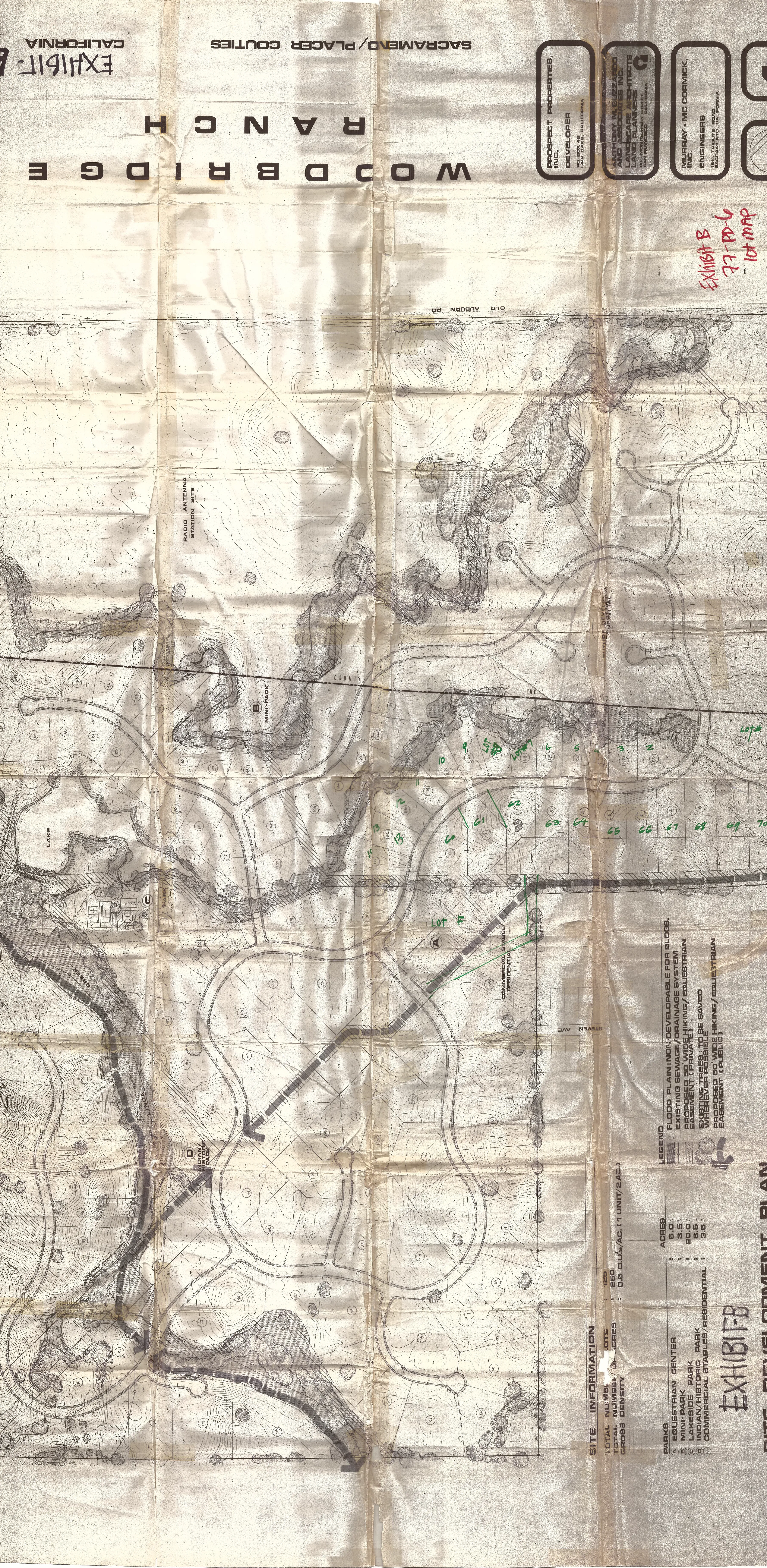
- B. Lot Map
- C. Park Development Plan (Lakeside Park)
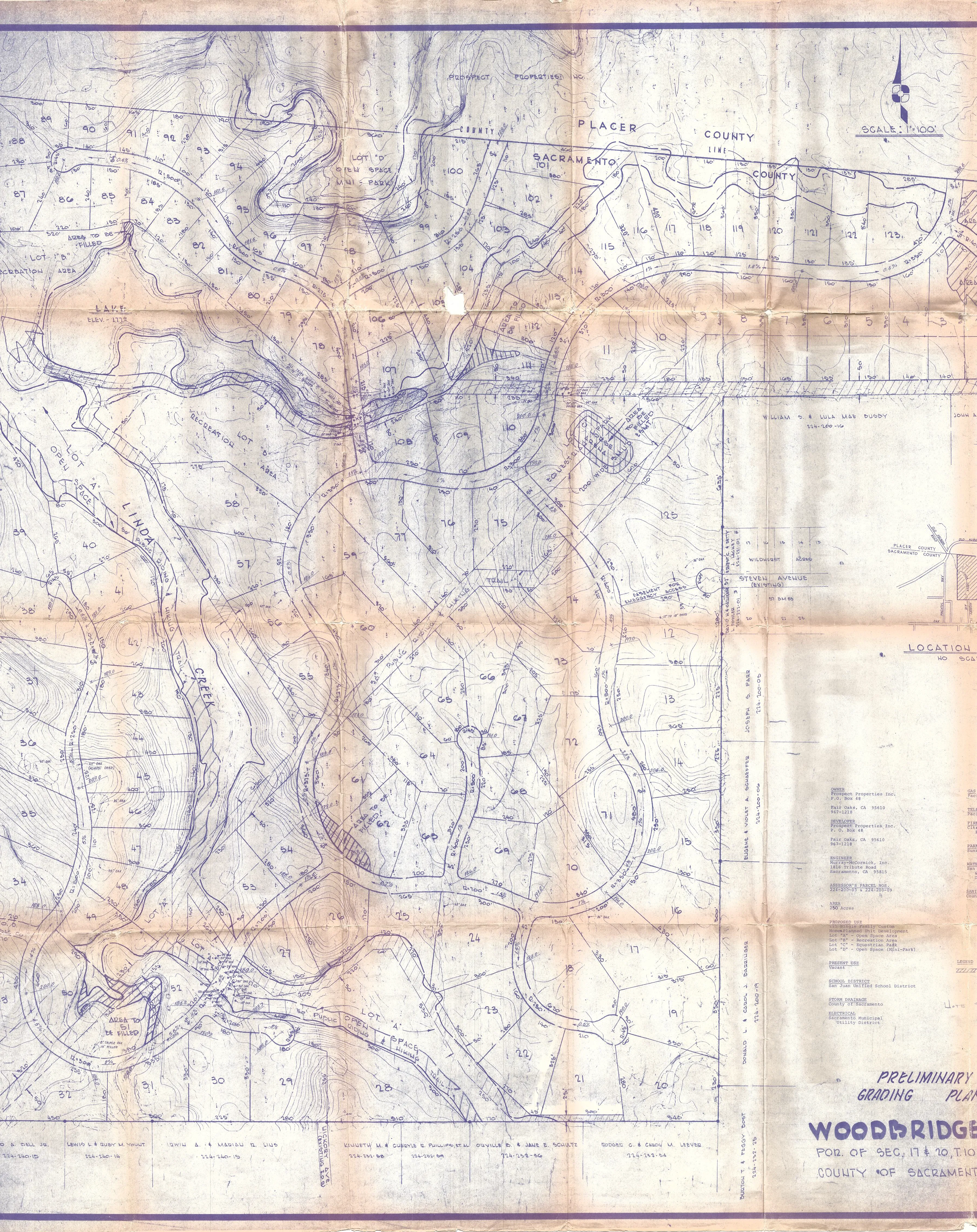
- D. Grading Plan
SECTION 4. PERMITTED USES
Section titled “SECTION 4. PERMITTED USES”On each lot, Lot 1 through 124, as shown on Exhibit “B”, the following uses shall be permitted:
- One single family detached dwelling.
- Incidental Agricultural Uses.
- Customarily Incidental Accessory Uses and Buildings.
On Parcel “C” as shown on Exhibit “A”, those uses shown on Exhibit “C” shall be permitted.
Parcel “B” as shown on Exhibit “A” shall be used for a park, playground, or other outdoor sport or recreational use.
On Parcel “A” as shown on Exhibit “A”, a riding stable, barn, shelter, paddock, riding ring, exercise yard, and similar equestrian uses, shall be permitted.
Parcel “D” as shown on Exhibit “A” shall be used as an undeveloped Indian-historical park, except for the installation of the riding and hiking trail as shown on Exhibit “A”. Prior to the installation of the riding and hiking trail, the owner or developer shall obtain an archaeological survey or investigation which records any significant archaeological site or artifact with the Sacramento County Environmental Impact Report Section.
On Lot 125 as shown on Exhibit “B”, either a commercial riding stable shall be permitted, or any use specified above for Lots 1 through 124 shall be permitted.
SECTION 5. CONFIGURATION OF LOTS AND DESIGN OF PROJECT
Section titled “SECTION 5. CONFIGURATION OF LOTS AND DESIGN OF PROJECT”The location, configuration, and arrangement of the lots within the area described in Exhibit “1” shall be as shown on Exhibit “B”. Buildings shall comply with the development standards set forth in Title III of the Zoning Code of Sacramento County; provided, however, that no buildings shall be permitted within the flood plain of Linda Creek as delineated on Exhibit “D”, nor shall any buildings be constructed on Lots 41, 56, 57, and 58 as shown on Exhibit “B” until an archaeological investigation by the County is completed. The cost of such investigation shall be paid by the developer, but shall not exceed the sum of $500.00. Construction of residences on said Lots 41, 56, 57, and 58 shall be within the building envelopes shown on Exhibit “A-1”. No development of the park sites shown as Parcels A, B, C, and D on Exhibit “A”, nor of Lot 37 as shown on Exhibit “B”, shall be permitted until a development plan has been submitted to the Planning Department for approval. The Planning Department should limit its review to the following:
- Location of the trees to be removed and to be retained
- Lot grading
- Location of improvements on the lot taking into consideration the size and configuration of the lot
The review provided by this section shall not render said lots undevelopable to the uses and densities established herein. No road or trail crossing Linda Creek or the lake tributary thereto shall be constructed without first obtaining the approval of the Project Planning Commission. The Project Planning Commission shall limit its review of the plans of such crossings to whether any trees which may feasibly be preserved are preserved, and whether the design of such crossings is architecturally compatible with the design of the proposed project.
SECTION 6. PUBLIC STREETS
Section titled “SECTION 6. PUBLIC STREETS”The original adopted document cites “Stevenson Avenue,” which is a street in South Sacramento. It is presumed that the planners meant “Steven Avenue,” which is a street that abuts Woodbridge Ranch.
The location, configuration, and arrangement of streets shall be as shown on Exhibit “B”. The interior streets of the development shall be offered for dedication as public streets with the rights-of-way shown on Exhibit “B”. Said public streets shall be constructed in conformance with County Standards for Class “B” or Class “C” Streets. An emergency fire access shall be provided at Stevenson Avenue. The design of such access and any temporary barriers shall be approved by the Public Works Department of the County prior to the construction thereof.
SECTION 7. GRADING
Section titled “SECTION 7. GRADING”No grading shall be permitted on the property described in Exhibit “B” without first obtaining a grading permit pursuant to the provisions of Chapter 16.44 of the Sacramento County Department of Public Works, except for such grading as is necessary to provide adequate drainage, or for those purposes provided in Section 16.44.090 of the Sacramento County Code, or to the placing of fill in those areas indicated on Exhibit “D”.
SECTION 8. TREES
Section titled “SECTION 8. TREES”The design, layout, and configuration of the improvements shall be accomplished so as to minimize the removal of trees. No trees having a diameter of nine inches or more, measured four and one-half feet above the ground, shall be damaged or removed unless:
- The trees are located within the right-of-way of an approved street or approved building envelope.
- The trees are specifically approved for removal by the Planning Commission or Planning Department as part of the site plan approval.
- Such removal is necessary for elimination of diseased growth, for fire prevention and control, erosion and flood control, or as may be required for pedestrian, bicycle, or equestrian paths and trails.
SECTION 9. SIGNS
Section titled “SECTION 9. SIGNS”No signs shall be constructed upon the property except those signs authorized in Chapter 35, Article 1 of the Zoning Code of Sacramento County, and monument signs at the location, and with the size and design shown on Exhibit “E”.
SECTION 10. SUSPECTED FAULT RESULTS
Section titled “SECTION 10. SUSPECTED FAULT RESULTS”Whenever during the course of excavation or trenching such excavation or trenching reveals any evidence relative to the identification of any earthquake fault, no further excavation shall take place until the site is examined by a qualified geologist to determine the extent of such fault and its effect upon proposed construction in the vicinity. The geological report should be reviewed by the Project Planning Commission to determine whether an amendment to this ordinance is required.
SECTION 11. RIDING AND HIKING TRAILS
Section titled “SECTION 11. RIDING AND HIKING TRAILS”The developer shall construct riding and hiking trails at the location shown on Exhibit “A”.
Such trails shall be maintained by the developer or by a homeowners association, until such time as such easements are accepted for dedication by the County.
SECTION 12. HOMEOWNERS ASSOCIATION
Section titled “SECTION 12. HOMEOWNERS ASSOCIATION”The Articles of Incorporation and Bylaws of the Homeowners’ Association, the prospective owner of the common area, and the Declaration of Covenants, Conditions, and Restrictions shall be approved by the County Counsel prior to the issuance of the building permit for any dwelling unit. The Declaration of Covenants, Conditions, and Restrictions, the Articles of Incorporation, and the Bylaws shall provide that the same may not be amended without the concurring approval of Sacramento County. The documents shall also provide that the County of Sacramento shall be able to enforce the provisions of the documents which relate to the maintenance of the common open space.
SECTION 13. FINDINGS
Section titled “SECTION 13. FINDINGS”During the public hearings on this ordinance the Planning Commission and the Board of Supervisors determined that:
- The proposed development will carry out the intent of the General Plan.
- The proposed development is of sufficient size and is designed so as to provide a desirable environment within its own boundaries.
- The proposed development is compatible with existing and proposed land uses in the surrounding area.
- Exceptions to the standard requirements of the Sacramento County Zoning Code, Ordinance No. 1111, are justified by the design and development.
- The arrangements of dwellings and mixing of dwelling types is justified by larger and more usable open spaces.
- There is adequate assurance that all public improvements will be installed at the scheduled times as required by the Public Works Department.
- There is adequate assurance that the development schedule will be met.
- The existing or proposed utility services are adequate for the uses and population densities proposed.
SECTION 14. VARIANCES
Section titled “SECTION 14. VARIANCES”The variance provision of Article 1, Chapter 18, of the Sacramento County Zoning Code, Ordinance No. 1111, as amended, shall not apply to this ordinance.
SECTION 15. VIOLATIONS
Section titled “SECTION 15. VIOLATIONS”Violation of the provisions of this ordinance or exhibits made part of this ordinance shall be deemed a violation of Sacramento County Zoning Code, Ordinance No. 1111, as amended.
EXHIBIT A. Site Development Plan
Section titled “EXHIBIT A. Site Development Plan”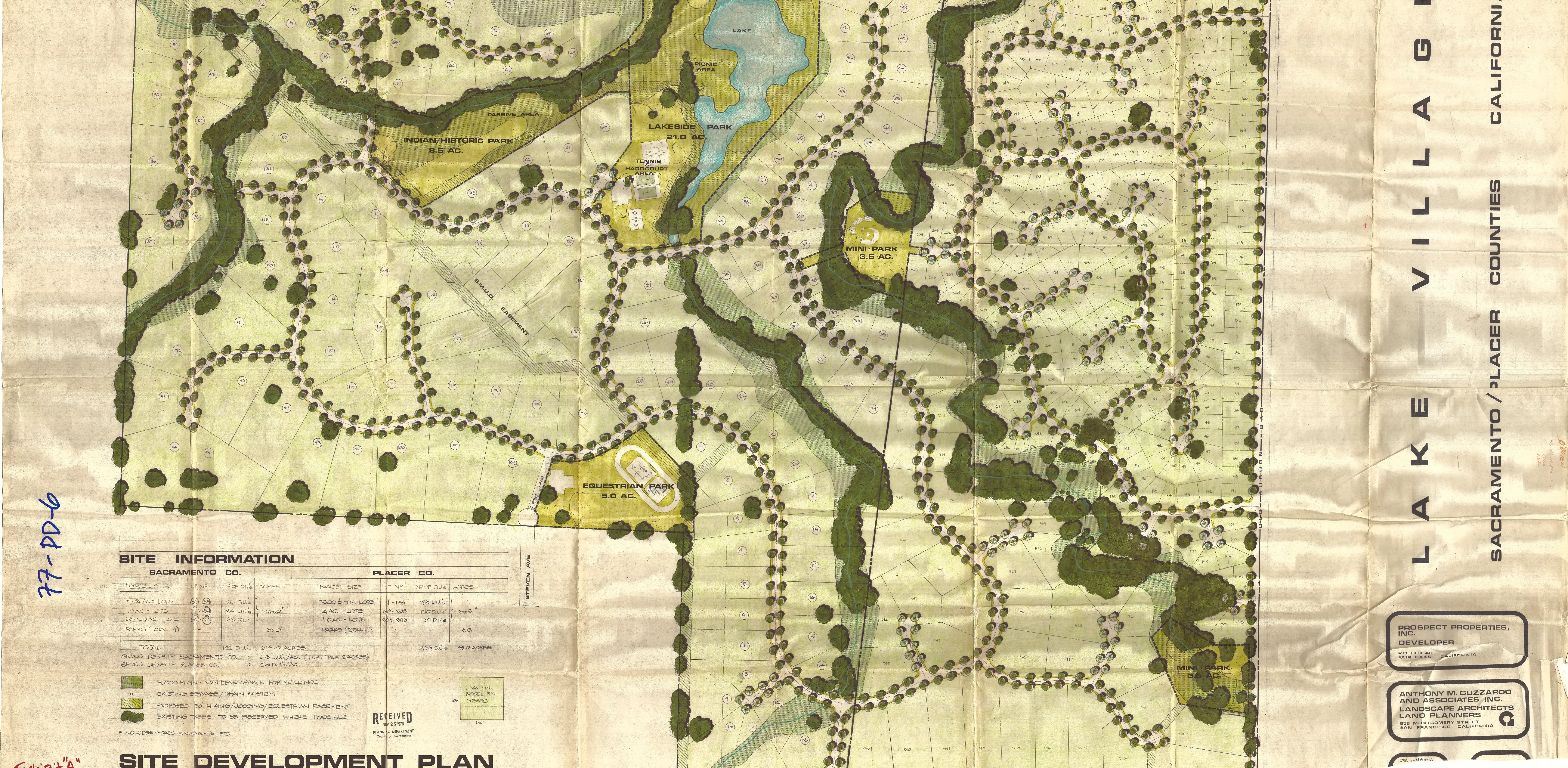
EXHIBIT A-1. Building Envelope Plan
Section titled “EXHIBIT A-1. Building Envelope Plan”This exhibit is not available online pursuant to CA GOV § 6254.10. This exhibit affects 8044 Indian Creek Drive; 8465, 8663, 8679, and 8693 Country Creek Drive.
EXHIBIT B. Lot Map
Section titled “EXHIBIT B. Lot Map”Amended July 24, 2001
An Amendment to the Original Subdivision Map relating to Lots 55 through 58 (recorded map Unit 1, Lots 18-21)’s lot configuration was accepted. This exhibit is not available online pursuant to CA GOV § 6254.10. This exhibit affects 8044 Indian Creek Drive; 8465, 8663, 8679, and 8693 Country Creek Drive.
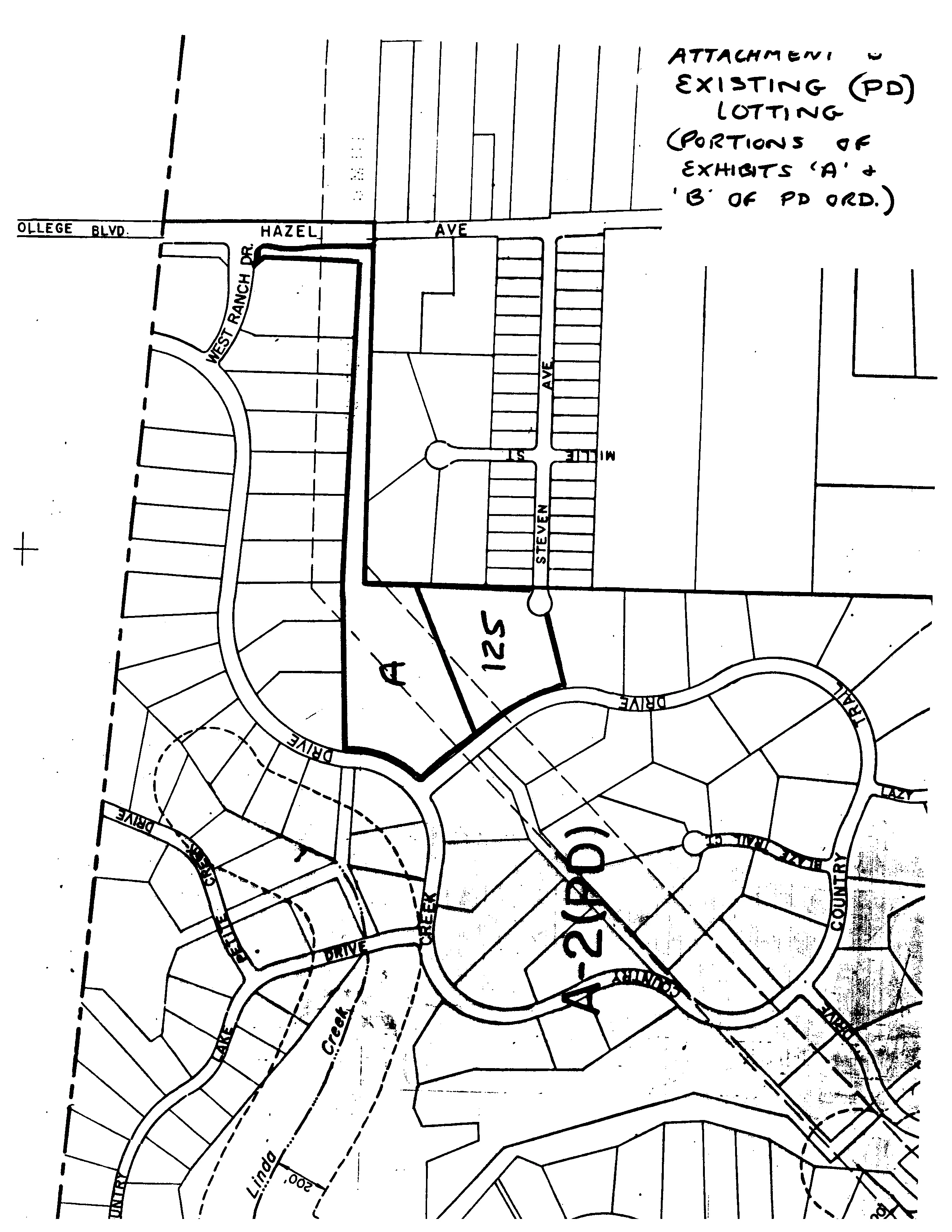
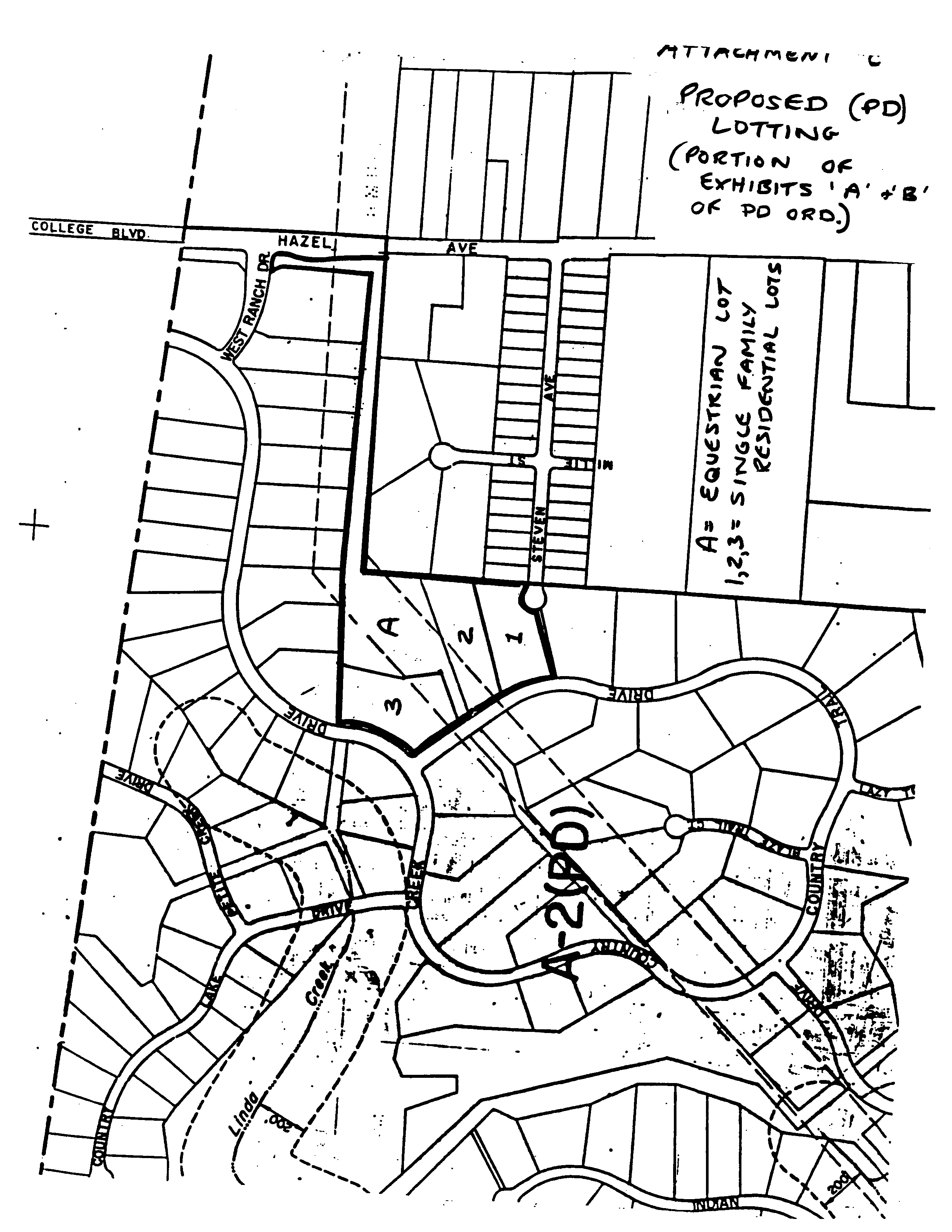
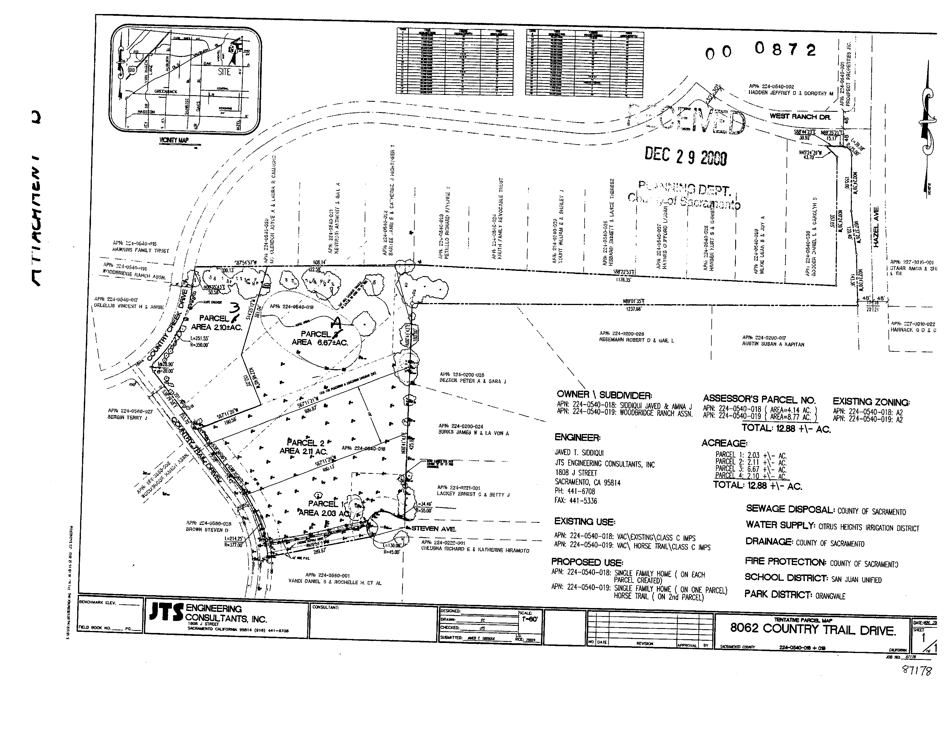
EXHIBIT C. Park Development Plan (Lakeside Park)
Section titled “EXHIBIT C. Park Development Plan (Lakeside Park)”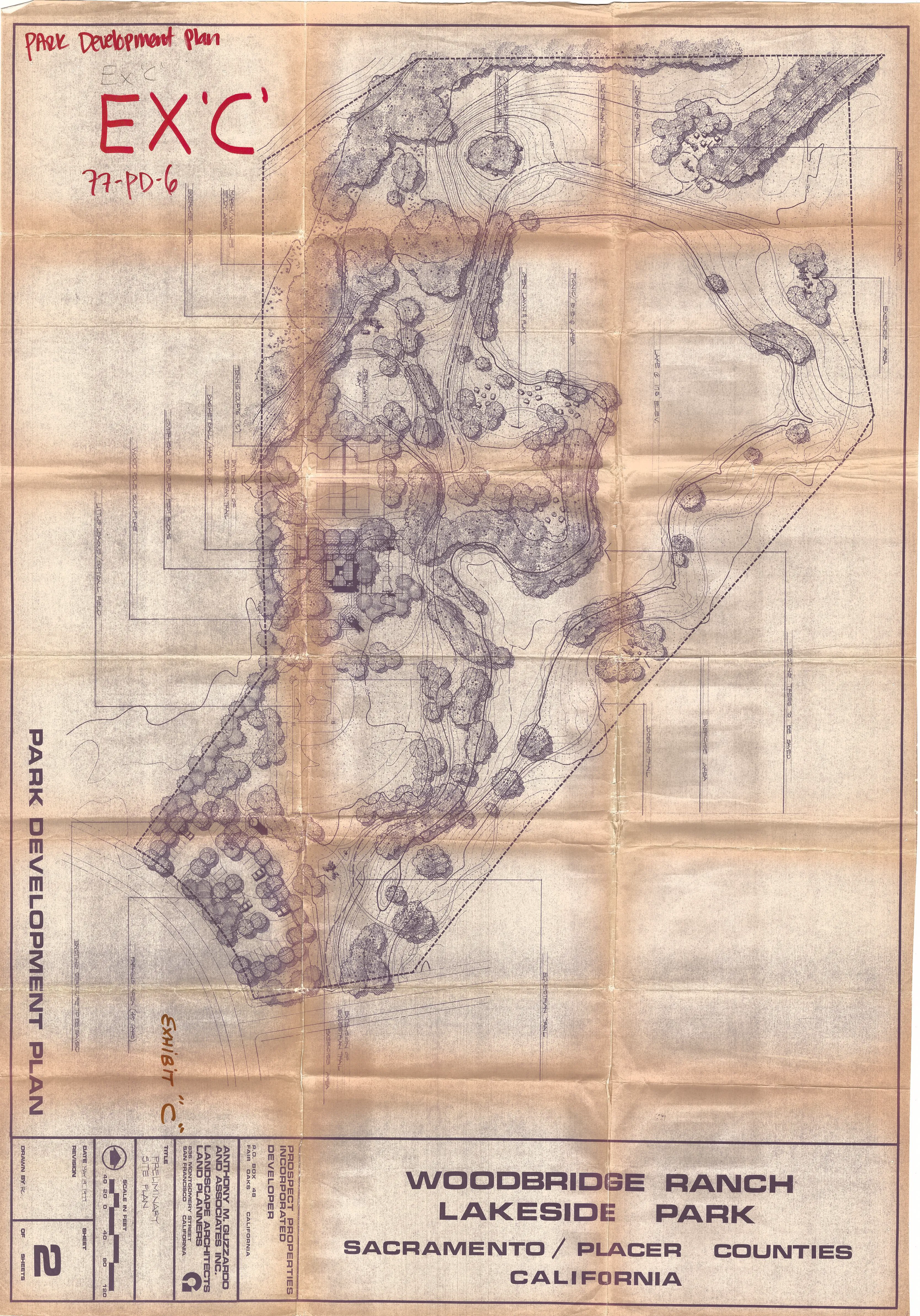
EXHIBIT D. Grading Plan
Section titled “EXHIBIT D. Grading Plan”