

Old Florin Town SPA
Sacramento County Zoning Code
Old Florin Town Special Planning Area Ordinance
Section titled “Sacramento County Zoning Code Old Florin Town Special Planning Area Ordinance”Adopted July 20, 2011
Amended October 22, 2022 & October 20, 2024 & June 11, 2026
Adopted by SZC-2011-0019 / PLNP2007-00075
Amended by PLNP2020-00233 (Sacramento County Active Transportation Plan) & PLNP2020-00042 (6th Cycle Housing Element Rezone Program) & June 11, 2026 (2024-2025 State Legislative Update)

BACKGROUND
Section titled “BACKGROUND”610-100 HISTORY OF FLORIN
Section titled “610-100 HISTORY OF FLORIN”The town of Florin has occupied a notable position in the history of California, both as an agricultural force in its strawberry and Tokay grape production and for the unique events that centered on the Japanese American population, which contributed so strongly to the community’s early success. Very few historic resources remain that reflect Florin’s earlier prosperity and its significant role in the development of the region and history of the state.
The colonial history of Florin began with an English born settler named James Rutter, who arrived in California in 1852. Rutter was working in Sacramento as a carpenter when the great fire of that year swept the city. Despite the loss of his tools in the fire, Rutter worked for $10 a day to help rebuild the city, which was a very high wage in those days.
Grapes and Strawberries
In 1858, Rutter moved south, becoming the first to settle in the area, near present day Florin Road and Power Inn roads, which later became known as Florin. Spanish cattle were grazing on the untilled land when he first arrived. Rutter obtained cuttings of Tokay grapes from Senator George Rich, who had imported them from Europe, and established the first commercial planting of Tokays in the state. Early in his farming career, Rutter survived a drought which spurred him to introduce irrigation into the area. He became a dedicated horticulturist as he cultivated both Muscat and Flaming Tokay grapes. His grapes won him many awards in the east and Midwest as well as California, thus bringing national recognition to the Florin area. It was cuttings taken from Rutter’s vineyards that were introduced to Lodi where they also flourished and brought fame to that area as well.
in 18 Buddhist Church 1942
According to common belief, the name of Florin was given to the locality about 1864 by Judge E.B. Crocker who noted the profusion of wildflowers in the area and commented that it should be called Florin, after the Spanish word flor, meaning flower. A post office was established in 1869, the same year the Southern Pacific Railroad (then the Central Pacific Railroad) completed its line through the area. However, the town was not officially established and its name accepted until 1875. That same year, L.L. Goddard and his brother in-law, Sugden established a general store. Within a short time, the town boasted a blacksmith shop, saloon, box factory and hotel. A schoolhouse was built by 1877 and a Methodist Church by 1885.
With the completion of the railroad, Chinese laborers began to arrive seeking agricultural work. The “stoop labor” encouraged local farmers to plant strawberries between the rows of grape vines, and the crop became extremely successful. The soil of the area is particularly suited to this combination of crops. The water table was within eight feet of the surface, making irrigation relatively simple. To reach the water, farmers created a proliferation of wells, each with its own windmill. Travelers through the area likened it to Holland.
While the Chinese had been free to immigrate to the United States in the 1850s, the Japanese had not. By 1885, a centuries-old ban on the emigration of Japanese from their country began to ease, and the first Japanese came to this country. In 1898, four Japanese families settled in Florin, leased some land, and began to grow strawberries. The successful cultivation of strawberries, first assisted by the availability of Chinese labor, grew in volume. By 1902, three shipping companies had been established in Florin, and strawberries were being shipped by train to locations as far away as Chicago and the Mississippi Valley. This success attracted more Japanese who were anxious to find employment and would work for low wages.
Florin windmills
The Japanese began to lease and work land for a share of the crops. To make their lease arrangement more profitable, they would plant grape vines between the strawberry rows, and by the time the life of the berry plants was finished, the grape vines had matured. Their diligence and hard work was rewarded with success, and they began to buy the land they farmed. Because of their willingness to work hard, their employment grew in the fields and in local industries, such as the box factories, and the ownership and operation of local stores and businesses. The rapidity and extent of their success and expansion in a very short span of years may have intimidated and threatened Caucasian farmers and settlers of Florin and other areas as well. The extent of Japanese ownership in Florin became so dramatic that this small community attained national notoriety and became the focus of political prejudice
Packing sheds
Although the immigrants viewed themselves as simple farmers, they were worried about the power struggle that was taking place for control of the Pacific Rim, where both the United States and Japan were aggressively seeking territory. A potential clash between the two Pacific powers seemed by many to be inevitable. The ethnic gap widened in Florin between the Japanese and Americans in the early teens. The Japanese population in Florin greatly increased and by 1912 appeared to equal or even outnumber Caucasians. On May 1, 1913, the editors of the Sacramento Bee complained that the Japanese controlled and owned the town of Florin with “…only one white man in business in a country town once a sflourishing community of sturdy American farmers…less than onefourth of its population of 500 are white. The school, built for the children of white men, is now almost half Japanese. In one room there are twenty white children and twenty-two Japanese.”
7 Mile House
In 1913, the Anti-Alien Land Bill excluding Japanese from land book ownership was passed. By 1916, the construction of a school for the education of Florin’s children became important to the community. However, prejudice and fear of the Japanese population continued to grow. In 1919 Valentine S. McClatchy resigned as publisher of the Sacramento Bee to actively participate in the anti-Japanese campaign. McClatchy worked in conjunction with the Japanese Exclusion League of California and the California Joint Immigration Committee.
The rural communities of Florin, Walnut Grove, Isleton and Courtland in Sacramento County adopted the legislative amendment and established separate schools for Asian students. Florin East School housed the Japanese children after Florin West was built in 1923 to house the Caucasian children.
The Florin Grammar School became segregated with the construction of another for Caucasian children across the railroad tracks to the west. This segregation apparently reflected community life in Florin as well. There were no Japanese members in either of the two major fraternal organizations, nor the Grange. A separate Mission administered the Japanese Methodist Church, and a Japanese Buddhist congregation became the largest religious entity. Many, if not most, local businesses were Japanese owned and operated.
Old Florin Depot
In 1924 the struggle came to its height when the U.S. Congress adopted a new immigration bill. The Japanese were given a quota of 250 per year. Eventually, in 1939, the policy of segregated schools in Florin was reversed, a short-lived gesture toward a mutual understanding. In 1941, with the onset of World War II and the Japanese attack on Pearl Harbor, fear gripped the west coast. With much of the Pacific fleet destroyed or damaged, the west coast was vulnerable to invasion. As a result, Japanese Americans all over the state were ordered to internment camps. The Japanese Americans in Florin were gathered and put on trains to internment camps for the duration of the war. Their removal from Florin essentially caused its demise, because 80 percent of the population at that time was Japanese American.
Main Street Florin 1943
After the Japanese Americans had been sent to internment camps, many homes and businesses were boarded up and vacant. Old wooden buildings vacant and not properly maintained are quite susceptible to fire. A newspaper article in the Sacramento Bee, July 21, 1944, chronicled a devastating burn: “Nine buildings, including seven residences and a commercial garage which was being outfitted as an insulation plant, were destroyed by fire which swept the former Japanese section of Florin.”
One of the buildings that burned was a warehouse containing the furniture and personal effects of a number of Florin Japanese American residents. The Bee article mentioned the loss of pianos, washing machines, refrigerators, and bedding. The area devastated was on the north side of Florin Road, running from Tokay, east to the Southern Pacific right-of-way. It included the concrete building now know as Florin Tractor Parts, which lost its roof and interior. At that time it was known as Grays Garage and it was being refitted to house the insulation plant.
When the war was over and the Japanese Americans returned to Florin, there was little of what they had left. The agricultural lands and residences that remained had suffered from a lack of care and maintenance. The markets had changed and could not support the same type of pre-war agricultural activity. A number of former Japanese American residents left the area and turned to other vocations. Changing markets and the loss of so many of its former residents started the town of Florin on a path of decline.
On August 26, 1964, fire again visited Florin and destroyed the 1890 Old Fellows Hall, which was located on the south side Florin at Frasinetti Road. The two-story wood frame building at one time housed on the ground floor the Florin Food Market and, at the time of the fire, the Florin Mart. The meeting rooms for the lodges (Odd Fellows and Rebekahs) were on the second floor.
Today what remains of the Florin agricultural community is vacant land which was once productive and verdant, but is now surrounded by an encroaching city. Florin has lost some of its identity, and a number of its old structures have been destroyed. However, there is still an identifiable core of residences, churches and commercial buildings that can evoke a sense of the time and place when old Florin Town was the center of a thriving agricultural community.
Aging building in Florin
SPA OVERVIEW, DISTRICT DESCRIPTIONS AND COMMUNITY STANDARDS
Section titled “SPA OVERVIEW, DISTRICT DESCRIPTIONS AND COMMUNITY STANDARDS”610-111 INTRODUCTION AND INTENT
Section titled “610-111 INTRODUCTION AND INTENT”The town of Florin is located about 10 miles from downtown Sacramento in the unincorporated portion of Sacramento County. The thousands of acres that comprise the Florin area used to be farms and ranches. Many of the families who have called Florin home for generations still live in Florin, although most of the businesses have now closed.
In recent years, local residents and business owners have expressed concern about the increased levels of traffic and congestion, and their collective impact on public safety and quality of life. Large underutilized and vacant land in the area (see image on page 6), coupled with growing development pressure to the east, continue to feed the fears of community members that the charm and history of Old Florin Town will be forever lost.
The Sacramento County Board of Supervisors, in an effort to preserve this fragile historic community, voted to “downgrade” the long range transportation plan for this section of the Florin Road corridor from six to four lanes (Sacramento County’s 1993 General Plan called for six lanes of traffic - three in each direction). That decision was central to the corridor streetscape design and was critical to the preservation of many historic structures.
OFT Aerial Exhibit
Section titled “OFT Aerial Exhibit”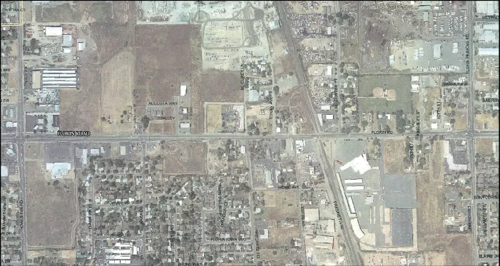
This SPA will address relevant land use planning issues taking into consideration the design elements of the Streetscape Master Plan, a direct outcome of the board’s decision. Finally, it should be noted, where the OFT SPA is silent the Sacramento County Zoning Code will apply.
610-112 CORRIDOR IDENTIFIERS AND DISTRICT THEMES
Section titled “610-112 CORRIDOR IDENTIFIERS AND DISTRICT THEMES”Over a two-year period, community members assisted in the development of a Vision for Old Florin Town (OFT), as well as the Streetscape Master Plan for the corridor. Many of the design details in the Streetscape Master Plan complement other planning efforts on the corridor. Although a majority of those improvements will take place outside the boundaries of this SPA, a number of general themes and concepts will be included in this ordinance.
Early insignia design
Insignia
Section titled “Insignia”The OFT insignia was developed during the OFT visioning process and is an interpretation of a flowering Strawberry plant. As previous outlined, the role of the Strawberry in Florin’s history is well chronicled as were the abundance of flowers in the community. This insignia shall be incorporated into the Streetscape Master Plan and should be a part of any public landscaping, park, community improvement or historic project. The insignia may also be incorporated into privately funded projects in and around the public right-of-way (bus stops, street furniture, etc.).

Monumentation
Section titled “Monumentation”Windmills and water towers have been fixtures in the community for more than 100 years, and both farming structures have become central to the gateway monument concept. Although monumentation is most likely to occur in the Gateway Areas, there may be additional applications in the Historic Village Center (e.g. depot area). Samples of historic windmills, water towers and conceptual monuments are shown below.
Windmill (left) and Water Tower (center) – combined to become Monument Concept (right)
610-113 SPA ORGANIZATIONAL OVERVIEW
Section titled “610-113 SPA ORGANIZATIONAL OVERVIEW”Except as provided herein, the definitions in Article 1, Chapter 25 of Title I of the Sacramento County Zoning Code shall apply. The OFT SPA ordinance is organized as follows:
- Intent (Section 610-111) – speaks to the interests of the community and Sacramento County as reflected directly, or referred to indirectly, in the SPA ordinance.
- SPA Sub-Areas – (Section 610-114) refers to the land uses plan for the Old Florin Town SPA, supported by the community and outlined on Exhibit A.
- Community Standards and Historic Structures - Introduction (Section 610-115) – refers to the intent language and a description of the properties that best represent the character of the community with respect to design and planning.
- Process (Section 610-116) – refers to the Standard Project Review Process as outlined in Section 610-118. It has been structured to accommodate community input during the planning and design phases of all projects, while at the same time providing flexibility for property and business owners seeking approval on projects.
- Development and Design Standards (Section 610-125) – these are standards for development in all areas of the SPA (additional standards for residential, historic, industrial and commercial projects).
- Design Guidelines (Summary in Section 610-130) – These Design Guidelines provide project applicants with a series of design standards for all projects in the SPA. Additional design guidelines are outlined in greater detail for the Historic Village Center (properties listed in Exhibit B).
- Streetscape Master Plan (Appendix) – refers to the Streetscape Master Plan adopted by the Board of Supervisors in 2007. Applicable components and themes of the plan are incorporated into this ordinance and outlined in this section. A complete copy of the Streetscape Master Plan is not included in this document, but is available in the Sacramento County Planning or Transportation departments.
- Parcel Maps and Subdivisions (Section 610-133) – refers to land to be developed and/or subdivided in the SPA.
- Findings(Section 610-135) – refers to the approval or denial of a project application.
- Exhibits - Exhibits include a SPA Project Area and Boundary Map and a Historic Village Center Overview and Structures List.
- Resource Directory – a directory of rehabilitation and restoration resources is included as an attachment to the ordinance for the use of property owners, project applicants, and area residents.
610-114 SPA SUB-AREA DESCRIPTIONS
Section titled “610-114 SPA SUB-AREA DESCRIPTIONS”In its entirety, the OFT SPA is centered around the Florin Road csorridor from Power Inn Road (including the commercial properties on the NW and SW corners of the intersection) on the west and Florin-Perkins Road on the east.
As an outcome of the community visioning exercises undertaken in 2004/05, the SPA has been divided into sub-areas to provide specific standards and guidelines for development. The SPA boundary and land use plan is depicted below. Existing buildings, structures and uses permitted with the OFT SPA as of the effective date of this ordinance shall continue to be permitted and exempt from the requirements herein.
OFT SPA Land Use Plan
Section titled “OFT SPA Land Use Plan”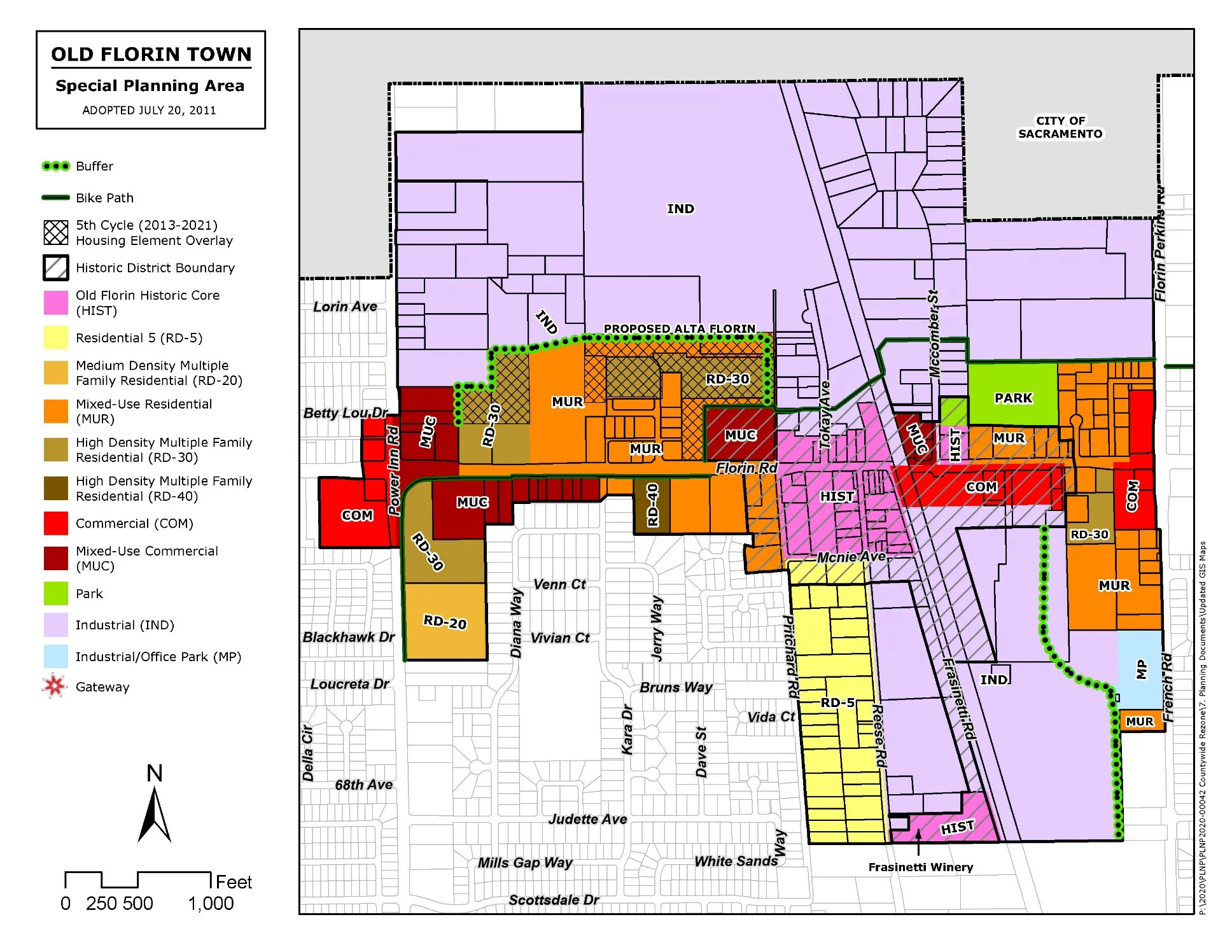
Historic Village Center
Section titled “Historic Village Center”The town of Florin played an important role in the state agricultural history, particularly during the first two decades of the twentieth century. A large number of social halls reflected local interest in community interaction, and churches demonstrated the community’s interest in religion. The town reflected its diverse composition with both groups maintaining their own churches and opening stores selling a variety of goods, filling local needs at that time and later converting to different uses as the community changed.
Residential structures within the Historic Village Center show variety in style and era, and service buildings reflect the work or products they provided. World War II saw the town change dramatically with the relocation of its many Japanese and Japanese American residents. A number of the buildings left behind became vacant and unused, and several fell victim to fire over time. Those that remain are important reminders of the town.
Historic Core Concept
There is a small group of historically significant buildings remaining from the original town of Florin, which extends along Florin Road from about Kingsley Court on the east to McCurdy Lane on the west. These buildings are almost all that remains of the original community of Florin.
While a number of the original Florin buildings have been demolished, altered or burned over time, this small historic core remains. This group of buildings still reflects the original character of the settlement and conveys a sense of a time and place belonging to its era. The buildings demonstrate the size, scale and materials of the original settlement structures. The cumulative visual character of the individual buildings constitutes the Historic Village Center.
An OFT Historic Village Center has been identified in the SPA, on both the north and south side of Florin Road, just west and east of the railroad tracks. The Historic Village Center is comprised of two areas: a) the Historic Core Area, and b) the Historic Buffer Area. It consists of approximately 18 percent of the entire SPA, and is highlighted in pink on the land use plan. The period of significance dates from 1870 to 1947.
The OFT Historic Core (highlighted in red in the diagram above) is comprised of 19 buildings, on 33 parcels. Its principal buildings reflect the character of the original town.
The area highlighted in red is now highlighted in grey.
Historic Core – The Depot Area
Section titled “Historic Core – The Depot Area”A series of improvements to the depot portion of the Historic Core have been recommended as part of the Streetscape Master Plan &and OFT Vision Plan, focusing on the great potential to revitalize the area with historic uses. Such improvements include pavers a&t the intersection of the railroad tracks and Florin Road; re-creations of historic structures such as packing sheds or train depots; and incorporation of monuments.
The Historic Depot area is defined as Florin Road to the north, the UPRR tracks to the east, Reese Road to the west and McNie Road to the south.
Historic Village Center – Buffer Area
Section titled “Historic Village Center – Buffer Area”The purpose of the Historic Buffer Area is an overlay to the underlying land use designations to provide for protective measures for the Core Area. The Design Guidelines in Section 610-128 apply to this area.
Gateway Areas
Section titled “Gateway Areas”The Florin Road Streetscape Master Plan includes the concept of Old Florin Town “gateways.” These gateways are small areas at the entrances to the community, and include area specific signage and monumentation. These gateways areas are the corners east of Florin and Power Inn roads, and west of Florin and Florin-Perkins roads.
Gateway concept - 2005
Each of these community Gateways Areas are primarily defined as street frontage within 100’ of the intersections. Windmills or water towers shall be key components of the monument design and district signage shall be incorporated (using the insignia shown in Section 610-112).
Residential Areas
Section titled “Residential Areas”There are a number of Residential Areas in the SPA, ranging from low density (RD 5 – five units per acre) to high density (RD 30 and RD 40 and greater). Although most of the existing residential development in the immediate area is lower density, with only pockets of higher density residential projects, there is tremendous opportunity in the area for additional higher density residential units.
Mixed Use Residential (MUR) – The SPA encourages smart growth development with the creation of this Mixed Use Residential (MUR) zoning designation. The MUR zone accounts for 80 percent of all residential zoning in the SPA. These MUR areas are located primarily on properties contiguous to the Florin Road corridor. These key parcels are well positioned to take advantage of public transit (future) and improved access to local goods and services. This area is intending to allow up to 20 units per acre with a target of an average of15 du/acre to provide for a mix of housing types with commercial as the secondary, supportive use. Note – the CPAC recommends an average of10 du/acre.
Low density residential areas (Single Family – RD 5) are highlighted in yellow on land use plan, Mixed Use Residential (Single or Multiple Family) is highlighted in orange, medium density multi-family residential (Multifamily RD 20) is the area highlighted in brown, high density multi-family residential – RD 30 is highlighted in dark green, and high density multi-family residential – RD 40 is highlight in dark blue on the land use plan (See land use key on black and white versions of the SPA map for corresponding codes). Senior housing is encouraged within these residential areas.
The Land Use Plan identifies a Housing Element overlay for 22.5 acres of land located north of Florin Road in the vicinity of Bacchini Street. The overlay designation is applied to several parcels that were recently rezoned to RD-20 in an attempt to comply with the 2013-2021 Housing Element Cycle requirement for the preservation of adequate multi-family zoned sites. These parcels have an underlying Mixed Use Residential designation and are recommended for an average minimum density of 15 dwelling units per acre.
The high density multi-family residential subareas (Multifamily RD 30/RD 40) were created to satisfy the 2021-2029 Housing Element Cycle Regional Housing Needs Assessment (RHNA) for lower-income households. The purpose of these residential areas is to preserve and promote opportunities for housing variety in the SPA, specifically affordable housing. These parcels will defer to the underlying zoning for permitted uses, with the exception that single-family homes are prohibited, unless developed at the minimum density applicable to the zone.
Commercial Areas
Section titled “Commercial Areas”Commercial areas outside the Historic Village Center are located primarily at the major intersections with retail being the dominant use.
Mixed Use Commercial (MUC) - The Commercial Areas are further defined in Section 610-121 (permitted uses) of this SPA and include areas of Mixed Use Commercial (MUC), which accounts for nearly 70 percent of the total commercial area. Similar to the MUR zone, the MUC parcels are positioned on the corridor to take advantage of the location, maximize densities and provide property owners with flexibility. Commercial uses dominate in this sub-area, although residential use is encouraged at the same average densities outlined under the MUR zone.
Mixed Use Commercial parcels are shown in brown and Commercial Areas in the SPA are highlighted in red on the land use plan.
Industrial Areas
Section titled “Industrial Areas”Industrial zoned properties account for the largest percentage (41 percent) of the total acreage in the SPA. These industrial areas can further be identified as the North and South Industrial Area. They are both highlighted in light purple on land use plan.
Concentrated in the northerly portions of the planning area and along the rail in the central and southern portion of the SPA, this zoning designation is only restricted in two ways: types of use and area specific development standards.
The Industrial Area immediately south of the Historic Core, west of Reese Road and north of the Frasinetti Winery, is designated for only light industrial uses (this is primarily for uses that include indoor activities). The North Industrial District allows all uses set forth in Title II, Chapter 1, Article 1, Section 201-02 under the Industrial Zone
The Industrial/Office Park designated site, located directly west of Florin Perkins Road and south of Florin Road, permits all uses allowed in the M-1 and MP zone, as set forth in the County Zoning Code.
Tsusaki Garage - 1943
Park Area
Section titled “Park Area”Although there is only one established park in the planning area, additional parkland will be identified as development moves forward, pursuant to County Land Development Ordinance. The existing Park Area is highlighted in green on the land use plan. It is important to note that the preliminary Historic Core Concepts include park-like public areas.
Enhanced Drainage Ways
Section titled “Enhanced Drainage Ways”In conjunction with the Parks and Open Space in the planning area, the Florin Creek Drainage Way represents an opportunity to provide additional recreation and open space in the community. As a part of the OFT Vision the planning team outlined a concept to provide pedestrian and bikeways in the area (along the drainage way) for area residents.
For additional drainage way standards see Section 610-125(b).
Enhanced Drainage Way
Circulation
Section titled “Circulation”The circulation plan for the Old Florin Town SPA consists of the following key components:
-
Ultimate build-out of Florin Road from Power Inn Road to Florin Perkins Road as a 4-lane facility
-
The construction of a new Alta-Florin Road as a four lane facility
-
A new grade separation at Alta Florin Road
-
Regional Rail designation for the Union Pacific Railroad Corridor
OFT SPA Circulation Plan
Section titled “OFT SPA Circulation Plan”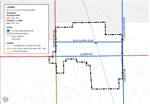
610-115 COMMUNITY STANDARDS AND HISTORIC STRUCTURES
Section titled “610-115 COMMUNITY STANDARDS AND HISTORIC STRUCTURES”Old Florin Town has a mix of architectural styles and motifs, attributable to a broad period of time (1870 to 1947). Community members and historic preservation consultants have indicated that these structures, listed on Exhibit B, represent the quality and type of design that is desired in future rehabilitation and new construction projects in the SPA. These structures have helped establish a community standard for development.
Through research and on-site review and analysis, this project has identified significant historic architectural resources located along Florin Road between Stockton Boulevard and Florin-Perkins Road. Structures older than fifty years of age were identified, researched and evaluated with respect to their significance, using National Register of Historic Places and California Register of Historical Resources criteria, in the Special Planning Area.
In addition, a list of historic structures is provided on Exhibit B. It is important to note that there were no officially designated structures at time of the SPA adoption in 2006. Further, historic structures on Exhibit B are also subject to the demolition requirements outlined in section 610-124 and 610-130 and specific provisions in the Residential and Commercial Design Standards (sections 610-126 and 610-127).
Redman’s Hall (2004)
PROJECT REVIEW PROCESS
Section titled “PROJECT REVIEW PROCESS”610-116 INTRODUCTION
Section titled “610-116 INTRODUCTION”The following section covers the project review process, including: definitions, a project process overview (for all projects), and list of permitted and prohibited uses in the SPA.
610-117 GENERAL REVIEW PROCESS DEFINITIONS
Section titled “610-117 GENERAL REVIEW PROCESS DEFINITIONS”Except as provided herein, the definitions in Article 1, Chapter 25 of Title I of the Sacramento County Zoning Code shall apply.
- SSCPAC means South Sacramento Community Planning Advisory Council.
- SHRA means Sacramento Housing and Redevelopment Agency, its agents and commission.
- FHS means Florin Historical Society.
- DERA means Sacramento County Department of Environmental Review and Assessment.
- CEQA means California Environmental Quality Act.
- New Construction. New buildings or structures not existing on-site on the date of adoption of this ordinance.
- Residential Dwelling Units. Units developed for residential purposes including and limited to apartments, rooming or boarding houses, townhouses, condominiums, half-plexes, duplexes and single-family dwellings.
- Exterior Remodeling. Any exterior modification that requires a building permit from the Sacramento County Building Inspection Division of Public Works.
- Interior Remodeling. Any work on the interior of the buildings such as new walls, and upgrading of the electrical and plumbing that requires a building permit.
- Existing Development. Refers to the existing, habitable (commercial, industrial or residential) structures in the area identified by Exhibit A.
- New Development. Refers to development in the areas of town where no development exists at the time of the adoption of this ordinance (undeveloped land/property).
- Dangerous Building(s). For the purposes of this Code, a dangerous building shall be as defined in Chapter 16.22 of the Sacramento County Code.
- Community and Civic Uses. Refers to projects and/or uses that are for the community’s benefit, and may include public meeting facilities, libraries, museums, and other community supportive facilities.
610-118 STANDARD PROJECT REVIEW PROCESS (all projects)
Section titled “610-118 STANDARD PROJECT REVIEW PROCESS (all projects)”The expansion of, addition to, or modification of an existing building, structure, or use in any of the districts may be permitted subject to staff plan review and the approval of the Planning Director to ensure that the proposed expansion is consistent with the policies and standard of this article.
Church of Christ on Florin
The following section outlines the project review process for all applications subject to review.
- Design Review - Building Permit Review Process (for all areas outside of the Historic Village Center). Design Review for all new construction shall occur pursuant to adopted design review procedures for nondiscretionary building permits. Design Review is conducted prior to and in conjunction with review of building permit applications. All building permits for construction projects, as set forth in Section 610-121, which are subject to this process are reviewed for compliance with the Zoning Code, this SPA, and the Commercial and Mixed Use Design Guidelines (if applicable). Design review is not applicable to minor permits where a determination is made that such construction is not visible from the public street. No further review, beyond a building permit, is required when all standards and use requirements of the Zoning Code, this SPA and the Commercial and Mixed Use Design Guidelines are met.
- Design Review – Building Permit Review Process (for construction in the Historic Village Center). In addition to the design review procedures outlined in (a) above, construction projects in the Historic Village Center shall be referred to SHRA and the Florin Historical Society for comment.
- Use Permits. Use permits shall be required for those uses as indicated in the Use Tables in the Zoning Code, or as specified in the SPA. The Use Permit process shall be in accordance with Title I, Chapter 10, Article 3 of the Zoning Code. In addition to the Zoning Code requirements, the distribution and elements of review shall include design review and conformance with the development standards and design guidelines in this SPA. Application review distribution shall include FHS, SHRA and the SSCPAC, and the intent of this SPA shall be considered.
- Rezones. Land use categories may be changed by rezone as provided for in Title I, Chapter 15, Article 2 of the Zoning Code. In addition to the requirements of the Zoning Code, the application review distribution shall include FHS, SHRA and the SSCPAC, and the intent of this SPA shall be considered.
- Special Development Permits. Projects within the SPA that are designed to achieve the purposes set forth in this SPA but do not conform to the development standards may be considered through the Special Development Permit process, as provided for in Title I, Chapter 10, Article 6. In addition to the requirements of the Zoning Code, the distribution and elements of review shall include design review and conformance with the intent of the design objectives in this SPA. Application review distribution shall include FHS, SHRA and the SSCPAC, and the intent of this SPA shall be considered.
- Uses Not Otherwise Provided For. Uses not provided for in this SPA may be considered by the Planning Director as set forth in Title I, Chapter 10, Article 3, Section 110-30.5.
MUR Example
610-119 EXISTING USES AND STRUCTURES
Section titled “610-119 EXISTING USES AND STRUCTURES”Each use and principle building in existence on the effective date of the original ordinance is deemed to be a conforming use and a conforming building. If a use existing as of July 20, 2011 is a permitted use as identified in Section 610-121, and if that use terminates after said date, it may be reestablished without conformance to building code standards or Title III Zoning Code standards, regardless of the length of time between reestablishment, provided such reestablishment does not represent a threat to public health and safety.
If a use existing as of July 20, 2011 is a prohibited use as identified in Section 610-120, or is otherwise not a permitted use as identified in Section 610-121, it may be reestablished within one calendar year from the date the use ceases, provided it is consistent with zoning and building code standards. If more than one year has elapsed, the use may be considered for re-establishment through a request for a use permit to be heard by the Project Planning Commission after a review and recommendation from the SSCPAC. Uses not listed in the Zoning Code or this SPA shall be subject to the process set forth in Title I, Chapter 10, Article 3, Section 110‑30.5.
Existing lots as of the date of this ordinance are deemed to be conforming in lot size and shape and shall retain building rights for any use permitted by the SPA.
Medium Density Residential
610-120 PROHIBITED USES (all areas of the SPA)
Section titled “610-120 PROHIBITED USES (all areas of the SPA)”[AMENDED 06-11-2026]
The following uses will not be permitted in the SPA:
- Psychiatric Facility
- Sanitarium
- Social Rehabilitation Center
- Massage Parlor
- Restaurants w/drive-throughs
- Tattoo Shop
- Live or Motion Picture Adult Theaters
- Bookstore - Adult
- Used Vehicles Sales
- Liquor Store (free standing)
- Check cashing stores
- Rehabilitation Facilities
- Gun Shops
- Pawn Shops
- Pool Halls
- Used Appliance Sales
- Bars (without restaurants)
- Tobacco Shops
610-121 PERMITTED USES
Section titled “610-121 PERMITTED USES”Unless prohibited in Section 610-120 above, uses within the general Land Use Categories shown on Exhibit A shall be determined by using the Land Use Tables in Title II of the Zoning Code as follows:
- Low Density Single Family Residential (RD 5). Limited areas in the SPA, adjacent to existing RD 5 development. Allows all uses set forth in Title II, Chapter 1, Article 1, Section 201-02 under the RD-5 Zone. All new development shall be consistent in lot area, lot width and density of Sections 215-50 and 215-52.
- Mixed Use Residential (MUR). Allows for multiple residential product types, but promotes and encourages higher density development (up to 20 units per acre) and allows for a maximum of 20% commercial (based on total project square footage). A mix of uses is encouraged in the project, although sole residential development is allowed. Permitted commercial uses in the MUR areas are office and retail. Community and/or Civic Uses are also permitted. Intent is to allow up to 20 units per acre with a target of an average of 10-15 du/acre to provide for a mix of housing types. (See map page 9, “Residential SubArea MUR.”).
- Medium Density Multiple Family Residential. Targets average densities of 15 units per acre. Allows all uses set forth in Title II, Chapter 1, Article 1, Section 201-02 under the RD-20 Zone. All new development shall be consistent in lot area, lot width and density of Sections 215-70 and 215-71.
- High Density Multiple Family Residential – RD 30. Targets densities of 22.5-30 units per acre. Allows uses set forth in Section 3.2.5. Table 3.1. of the Sacramento County Zoning Code under the RD-30 Zone. All new residential development shall comply with the objective development and design standards for multifamily development in Section 5.4. of the Sacramento County Zoning Code and the Countwide Design Guidelines. All other development shall comply with the development standards and design guidelines of the SPA.
- High Density Multiple Family Residential – RD 40. Targets densities of 30-40 units per acre. Allows uses set forth in Section 3.2.5. Table 3.1. of the Sacramento County Zoning Code under the RD-40 Zone. All new residential development shall comply with the objective development and design standards for development in Section 5.4. of the Sacramento County Zoning Code and the Countywide Design Guidelines. All other development shall comply with the development standards and design guidelines of the SPA.
- Commercial. Allows all uses set forth in Title II, Chapter 25, Article 1, Section 225-11 under the GC, General Commercial Zone, except those uses prohibited in Section 610-120. Mixed use is permitted in the Commercial District, provided that the ground floor is a commercial use. Housing is allowed on the second floor only and is not permitted on the ground floor in the Commercial Areas. Community and/or Civic Uses are permitted in the Commercial Areas and Mixed Use Commercial (MUC) areas. Refer to Zoning Code Section 225-42 for minimum lot size requirements.
- Mixed Use Commercial (MUC). The primary use in the MUC zone is commercial. Residential use, at a density of 10 units per acre, is permitted. Office and retail are the primary commercial uses in the MUC areas. Horizontal mixed use is permitted.
- Industrial. Allows all uses set forth in Title II, Chapter 1, Article 1, Section 201-02 under the Industrial Zone (M-1 and M-2 use zones). Industrial Areas to the south of Florin Road, and west of the Union Pacific Railroad shall be designated for light industrial uses (M-1 uses) only and shall have minimal impact on surrounding uses. See Section 610-129 for additional standards.
- Historic Village Center – Historic Core. Allows for Mixed Use Residential, Commercial, Mixed Use Commercial, Community/Civic, and Park uses as outlined in Section 610-121. Industrial uses are not permitted. All uses, projects and/or plans are subject to review of the FHS, SHRA and SSCPAC prior to approval. Historic uses are not required in structures in the Historic Village Center and in some cases may not be permitted. Design and treatments of the buildings are the primary concerns. All “re-uses” (even if is not a current or recent use, but is a historic use) are subject to approval as outlined in the Project Review Process in Section 610-118.
HVC Mixed Use
Permitted and prohibited uses in the Historic Village Center may vary from other areas in the SPA. Community and Civic uses in the Historic Village Center are encouraged, although, all projects are subject to review and approval as provided in Section 610-118. Projects may be denied because of negative impacts on surrounding projects, an over-saturation of Community and Civic uses in the Historic Village Center, or the project is incompatible or inconsistent with the stated vision of the community
Exhibit B highlights the properties in the Historic Village Center area, which includes a Historic Core.
Two-lane Florin Road
610-122 REVIEW PROCEDURES FOR PERMITTED USES
Section titled “610-122 REVIEW PROCEDURES FOR PERMITTED USES”Unless otherwise specified, all construction projects indicated as permitted uses, not requiring a use permit, in Section 610-121 shall be reviewed in accordance with the Design Review Advisory Committee process and as follows:
- Interior Remodeling is permitted with a Building Permit Review in all areas.
- Exterior Remodeling and Additions is permitted in all areas with review as described in Section 610-116.
- New Construction not otherwise requiring an entitlement under the requirements of this code is permitted in all areas with review as described in section 610-116 and 610-131 (where applicable).
610-123 DEMOLITION OF HISTORIC BUILDINGS
Section titled “610-123 DEMOLITION OF HISTORIC BUILDINGS”Significant historical architectural resources within OFT SPA shall be preserved in situ with all proposed modifications carried out to The Secretary of Interior’s Standards for the Treatment of Historic Properties with Guidelines for Preserving, Rehabilitating, Restoring and Reconstructing Historic Buildings. In the instance that demolition of a significant historical architectural resource is proposed, an Alternatives Analysis shall be submitted by the applicant to the Planning Department for review and endorsement. The Alternatives Analysis shall present alternatives to demolition that are site specific, such as relocation or adaptive reuse of the structure. If the Planning Department, in conjunction with the established review procedures in the SPA, determines that the only feasible alternative is demolition, than the applicant shall have an architectural historian prepare a historical report with archival prints of the structure, including architectural details, to be archived with the Sacramento Archives and Museum Collection Center (SAMCC) and the County of Sacramento.
Demolition Permits for structures, proposed to be completely removed from a site, shall be subject to review of the FHS, SHRA, SSCPAC and the Sacramento Design Review Advisory Committee and approval by the Planning Director. The Planning Director shall refer such proposals to FHS, SHRA, SSCPAC and Building Inspection for a coordinated review and recommendations.
The Planning Director’s determination is final unless appealed to the Board of Zoning Appeals pursuant to Title I, Chapter 15, Article 3 of the Zoning Code. Such appeals are subject to environmental review, in compliance with CEQA.
If the building is demolished, an application for development plan review by the Planning Director will be required when a new structure is proposed. The new structure shall be compatible with the architectural style, and materials of the buildings common to the area and will be subject to the Project Review Process as outlined in Section 505-608 of the SPA ordinance.
Dangerous buildings (as deemed by Planning Director and Chief Building Official) may be removed immediately in accordance with the procedures set forth in Chapter 16.22 of the County Code.
DEVELOPMENT STANDARDS & DESIGN GUIDELINES
Section titled “DEVELOPMENT STANDARDS & DESIGN GUIDELINES”610-124 INTRODUCTION
Section titled “610-124 INTRODUCTION”The general development standards section of this ordinance was developed by community members and is intended to provide flexibility for applicants during the design and development process, while at the same time creating some assurances that future projects will reflect the historic character of the community. The focus of this next section is on the project site and general appearance. If this ordinance is silent on any particular issue, the Sacramento Zoning Code shall apply.
610-125 GENERAL DEVELOPMENT STANDARDS (all projects)
Section titled “610-125 GENERAL DEVELOPMENT STANDARDS (all projects)”The section below outlines general standards for all projects in the Old Florin Town SPA. Specific standards, by sub-area, are outlined in Section 610-126 through 610-129.
General Standards for Building Structures
Section titled “General Standards for Building Structures”- Structure Height and Size. Variation in building heights is encouraged, as long as the project(s) does/will not negatively impact adjacent properties. Multi-story structures shall be designed to minimize impact on adjacent properties. Structures contiguous to Florin Road may not exceed 50 feet in height and any structure adjacent to the Historic Core may not exceed 35 feet in height. Building elevations should be designed to fit into the surrounding character of the neighborhood.
- Setbacks. Setbacks in the community do vary depending on location and the zoning (use) of the property. In general, new structures and/or additions in the Low Density Residential and Mixed Use Residential Areas should be compatible, as to not create negative impacts, with the existing street, side yard and rear yard setbacks of the structures in these areas. Reduced setbacks may be considered and supported upon review of the FHS, SHRA and SSCPAC and approval of the zoning administrator (or other approval bodies as outlined in previous sections). Additional setback standards, by area and use, are provided in 610-129 and 610-130.
In areas where no existing height has been established, the standards in the Zoning Code for the proposed use shall apply. Greater height may be considered through a Use Permit and is subject to review as outlined in Section 610-118(d).
Structures in the residential areas are subject to county footprint standards.
All projects and parcels contiguous to the Drainage Way, identified on Exhibit A, shall generally provide a 20 to 50 feet setback and easement to allow for the future development, and possible expansion, of Florin Creek (Enhanced Drainage Ways). The exact location and width of the easement, including appropriate setbacks, shall be determined during the review of development proposals seeking a planning related entitlement (i.e., rezone, use permit, development plan review and etc.). Projects seeking a building permit will not be subject to this easement or setback. The width of the easement and setback distance shall be reduced to account for site constraints and location of existing buildings and utilities. Furthermore, the new easement and setback distance can be waived on a case by case basis, if trail facilities and adequate setbacks can be achieved without requiring new easements. The easement and setback can also be waived if a suitable alternative trail location (i.e., along existing or planned roadways, including Alta-Florin) can be identified during the case-by case review of individual development proposals. Permitted uses and existing access points used by the parcel owners shall be maintained during project and trail design. As part of this review process, staff will also coordinate with the Southgate Park and Recreation to determine the exact location and width of the trail facility.
Additional setback provisions outlined overview provided in sections 610-121 through 610-131.
Lot screened w/fencing
General Standards for Site Improvements
Section titled “General Standards for Site Improvements”
Landscaped screens
- Fencing. Fencing is permitted in the Residential and Industrial Areas of the SPA with conditions outlined in the following sections. Although fencing is allowed without permit in Sacramento County, all project fencing is subject to review as outlined in Section 610-118 of the Project Review Process. Cyclone fencing is not permitted within the SPA boundaries, except in the Industrial and Drainage Way sub-areas as outlined in sections 610-130 and 610-132.
- Parking. Off-street parking shall be provided for uses in all areas, using standards of the Zoning Code as a basic guide for each use; however, lesser standards may be applied if deemed necessary by the Planning Department to be adequate for the proposed use considering the existing uses (and the parking demand of the proposed use), the availability of vacant land for on-site and off-site parking, parking agreements and any other solutions the applicant may propose. Minimum requirements are given in following chart.
It is the goal that community parking areas shall be developed to accommodate 50% of all parking generated by new development or redevelopment.
Access to parking lots should be from side streets and alleyways rather than from Florin Road. This will make them easily accessible and also keep them from detracting from the central streetscape.
For projects adjacent to alleyways, owners will be required to improve, where applicable, the appearance of the alleyways (per current Public Works standards). This may include repairing or replacing the existing flatwork, re-striping and resealing asphalt, providing additional lighting for added security, and providing addition of landscaping are all encouraged.
Applicant shall develop a comprehensive sign program for existing parking areas and will be strongly encouraged to establish collective parking areas. The sign program should be compatible with the imagery and character of the areas in which signage occurs.
New parking areas or garages should be located to the rear of buildings with access at the rear or side. Curb cuts on Florin Road are discouraged.
“Pocket lots” of 30 or less spaces shall be interspersed with landscaping (and buildings) and visually screened from the street. New screening shrubs should be 30”-48” high.
Additional parking considerations are listed in sections 610-127 and 610-128.
Parking pockets
| Parking Requirements | Total Min. Required | On-Site Minimum | Off-site/Shared |
|---|---|---|---|
| Commercial Retail | 1 per 300 SF | NA | 1 Per 300 SF |
| Office | 1 per 300 SF | NA | 1 per 300 SF |
| Commercial Mixed-use | Blended Requirement | NA | 1 per 300 SF for commercial |
| Residential Mixed-use | Blended Requirement | Blended Requirement | 1 per 300 SF for commercial |
| Residential Apartments | 1.25 per DU | 1 per DU | 0.25 per DU |
| Residential Townhouses | 2 per DU for 2+ BR 1 per DU for 1BR/S |
2 per DU for 2+BR 1per DU for 1BR/S |
NA |
| Live-work | 2 per DU | 1 per DU | 1 per DU |
| Other Uses | Per County Zoning Standards | Per County Zoning Standards | Per County Zoning Standards |
- Signage. Specific signage requirements, to be determined by use and project location, are included in sections 610-127 through 610-131. In general, three additional signage types should be accommodated in all cases, they include: historic district monuments (to be located at the gateways and major street intersections), walking tour signs for historic structures within OFT and any signage promoting civic uses or outdoor recreational facilities (i.e. enhancement drainage way, bike paths, etc.). Requirements of the applicant to install and/or incorporate said signage shall be determined by the Planning Director during the project review process, as outlined in Section 610-118. A-Frame signs are not permitted in the SPA.
- Lighting. Lighting in the SPA shall be consistent with area standards, with particular attention to lighting plans outlined in the Florin Road Streetscape Master Plan.
Prohibited A-Frame Sign
General Standards for Landscaping Improvements
Section titled “General Standards for Landscaping Improvements”- Landscape Plans. Specific landscaping requirements are not described in this section; however, the review authorities may require landscaping in areas where on-site and off-site parking is provided and where buildings are set back from the sidewalk. This landscaping requirement may be accomplished by provision of street trees, window boxes, hanging baskets, sidewalk planters, planter strips, shrubs or a combination of the items listed. Areas that may be required to be landscaped include side yards, back yards, or other open areas.
- Plant Species. All plant species in areas contiguous to Florin Road, or within 100 feet of the corridor, shall be consistent with identified species in the Florin Road Streetscape Master Plan. In general, all species should be indigenous to the area and drought tolerant.
- Street Improvements. Any street oriented improvements, such as furniture, landscaping, lighting, sidewalks, and other items around or near the public right-of-way shall be consistent with design and layout themes in the Streetscape Master Plan. See Florin Road Streetscape Master Plan for additional background details.
Conditions of Development Plan Review or Use Permit may require planting of these areas to retard erosion or to provide further visual amenities. If street trees are provided by the project applicant, they may be planted directly into the ground or in appropriate tubs. In all cases, landscaping required shall be designed to enhance the overall appearance of the area and should be consistent with the plant and tree species in the area.
General Standards for air quality, noise and climate change mitigation
Section titled “General Standards for air quality, noise and climate change mitigation”Development proposals that exceed the SMAQMD NOX screening levels shown in Table AQ-2 (Chapter 8: Air Quality, p.15-16), or any similar screening standard adopted by SMAQMD at the time of project application, shall be required to prepare construction emission estimates based on projected construction timelines and equipment lists prior to approval of improvement plans. When emissions exceed the SMAQMD construction thresholds of significance of 85 pounds per day of NOX, or the applicable standard in place at the time of application, the following measure shall be implemented:
The project shall ensure that emissions from all off-road diesel powered equipment used on the project site do not exceed 40 percent opacity for more than three minutes in any one hour. Any equipment found to exceed 40 percent opacity (or Ringelmann 2.0) shall be repaired immediately, and SMAQMD shall be notified within 48 hours of identification of non-compliant equipment. A visual survey of all in-operation equipment shall be made at least weekly, and a monthly summary of the visual survey results shall be submitted throughout the duration of the project, except that the monthly summary shall not be required for any 30-day period in which construction activity does not occur. The monthly summary shall include the quantity and type of vehicles surveyed as well as the dates of each survey. The SMAQMD and/or other officials may conduct periodic site inspections to determine compliance;
and,
The contractor shall provide a plan for approval by SMAQMD demonstrating that the heavy-duty (> 50 horsepower) off-road vehicles to be used in the construction project, including owned, leased and subcontractor vehicles, will achieve a project wide fleet-average 20 percent NOX reduction and 45 percent particulate reduction compared to the most recent CARB fleet average at time of construction; and the project sponsor shall submit to SMAQMD a comprehensive inventory of all off-road construction equipment, equal to or greater than 50 horsepower, that will be used an aggregate of 40 or more hours during any portion of the construction project. Acceptable options for reducing emissions may include use of late model engines, low-emission diesel products, alternative fuels, engine retrofit technology, after-treatment products, and/or other options as they become available. The inventory shall include the horsepower rating, engine production year, and projected hours of use or fuel throughput for each piece of equipment.
The inventory shall be updated and submitted monthly throughout the duration of the project, except that an inventory shall not be required for any 30-day period in which no construction activity occurs. At least 48 hours prior to the use of subject heavy-duty off-road equipment, the project representative shall provide SMAQMD with the anticipated construction timeline including start date, and name and phone number of the project manager and on-site foreman.
If, after the 20 percent NOX reduction afforded by implementation of the above, the SMAQMD thresholds of significance are still exceeded, then that development shall pay SMAQMD off-site air quality mitigation fees to reduce the project’s net construction NOX emissions below the significance threshold. The off-site mitigation fees shall be paid to SMAQMD prior to the approval of improvement plans or the issuance of grading permits. Developers should contact the SMAQMD for assistance in assessing the fee, based on the current rate of $16,000/ton of NOX or the prevailing rate in effect at the time of construction.
All development projects within the OFT SPA shall comply with the SMAQMD endorsed Old Florin Town SPA Operational Air Quality Mitigation Plan (09/28/2009), which requires implementation of reduction measures that will achieve a minimum of 15 percent reduction in operational and area source emissions, consistent with General Plan Policy. The AQMP shall be incorporated into the Old Florin Town SPA.
Future applicants of projects that have sensitive land uses, within 500 feet of the UP rail line, shall develop a mitigation plan to reduce impacts associated with toxic air contaminants, in consultation with SMAQMD. The mitigation plan may include measures such as vegetative plantings, the installation of electrostatic filters, and/or site redesign.
To ensure compliance with General Plan Noise Element standards of 45 dB Ldn or less for residential interiors, the following measure shall apply:
Any/all new residential construction shall be located at or beyond the 70 dB noise contour, as indicated in Tables NS-6 through NS-12 of the EIR.
Any departure or deviation from the above measure must be accompanied by an acoustical analysis, prepared by a qualified acoustical consultant and verified by the Department of Environmental Review and Assessment, substantiating that the General Plan Noise Element standard cited above is met.
To ensure compliance with General Plan Noise Element standards for non-residential interiors, as indicated in Table I of the Sacramento County General Plan (Table NS-3 of this EIR), the following measure shall apply:
Any/all new non-residential construction shall remain outside the 60 to 75 dB contour, as applicable, assuming a 25 dB standard construction reduction, unless sound resistant construction materials are utilized such that interior noise levels do not exceed the applicable noise level standards per Table NS-3 of this EIR.
Any departure or deviation from the above measure must be accompanied by an acoustical analysis, prepared by a qualified acoustical consultant and verified by the Department of Environmental Review and Assessment, substantiating that the General Plan Noise Element standard cited above is met.
To ensure compliance with General Plan Noise Element standards for interior noise levels at sensitive residential receptors subjected to railroad noise, the following policy shall be added to the SPA:
No use shall be operated or constructed that would result in interior noise levels at sensitive residential receptors that exceed the General Plan Noise Element noise standards. Proponents applying for sensitive uses in close proximity to the Union Pacific Rail Road shall submit a noise analysis substantiating compliance with interior noise standards of the General Plan Noise Element noise standards.
To ensure compliance with General Plan Noise Element standards for non-transportation sources, the following policy shall be added to the SPA:
No use shall be operated so as to generate recurring noises that are unreasonably loud or create a nuisance to any person of ordinary sensitivities. No nonresidential use shall be operated so as to generate any noise in an adjacent residential area, as detected in that area without instruments, that is louder than the noise which could be generally expected from uses permitted in that area.
If a loading dock is located within 100 feet of a residential use, an acoustical analysis shall be completed by a qualified acoustical consultant which recommends measures to minimize loading dock noise impacts, if necessary, on the residential uses and those measures shall be included in the project design.
Add a policy to the SPA requiring that future applicants for residential projects reduce residential emissions by 0.53 MT CO2 per capita, based on 2.7 people per residential unit. In consultation with the Department of Environmental Review and Assessment and Sacramento Metropolitan Air Quality Management District, applicants shall submit a plan detailing a set of quantitative and/or qualitative measures that achieve the reduction in CO2 emissions per capita, prior to the issuance of building permits or prior to obtaining any discretionary entitlements. This mitigation may be modified to conform with current Sacramento County climate change standards, including but not limited to a Green Building Program and Climate Action Plan. Additionally, applicants may choose to submit revised, project-specific, residential energy-use emissions factors; however, the applicant will be required to provide adequate data to support the revised emission factor.
Add a policy to the SPA requiring that future applicants for commercial projects reduce commercial emissions by 1.83 MT CO2 per Kft2. In consultation with the Department of Environmental Review and Assessment and Sacramento Metropolitan Air Quality Management District, applicants shall submit a plan detailing a set of quantitative and/or qualitative measures that achieve the reduction in CO2 emissions per Kft2, prior to the issuance of building permits or prior to obtaining any discretionary entitlements. This mitigation may be modified to conform with current Sacramento County climate change standards, including but not limited to a Green Building Program and Climate Action Plan. Additionally, applicants may choose to submit revised, project-specific, commercial energy-use emissions factors; however, the applicant will be required to provide adequate data to support the revised emission factor.
Add a policy to the SPA requiring that future applicants for industrial projects meet the applicable emission factors as follows:
8.08 MT per Kft2 of building, for energy usage
OR
2.42 MT per Kft2 of actively operated land area, for energy usage
AND (if appropriate)
0.05 MT per 100 vehicle miles traveled, for transportation
In consultation with the Department of Environmental Review and Assessment and Sacramento Metropolitan Air Quality Management District, applicants shall submit a plan detailing a set of quantitative and/or qualitative measures that achieve the reduction in CO2 emissions per the above factors, prior to the issuance of building permits or prior to obtaining any discretionary entitlements. This mitigation may be modified to conform with current Sacramento County climate change standards, including but not limited to a Green Building Program and Climate Action Plan. Additionally, applicants may choose to submit revised, project-specific, industrial energy-use emissions factors; however, the applicant will be required to provide adequate data to support the revised emission factor.
Inappropriate wall/fence
610-126 ADDITIONAL STANDARDS FOR RESIDENTIAL PROJECTS
Section titled “610-126 ADDITIONAL STANDARDS FOR RESIDENTIAL PROJECTS”This section outlines standards for all residential projects, including projects in the Mixed Use Residential areas.
Example of appropriate sign
- Parking. On-site parking shall be provided for all new residential development projects and shall be subject to review during the Project Review Process, as outlined in Section 610-118. Mixed Use Residential projects may share parking with other uses in project. In such cases appropriate shared parking ratios are not predetermined in this SPA and may fluctuate depending on project need, location, access to transit and the types of uses existing or proposed on the subject site. Parking pads, on low density residential projects, shall not cover more than 50 percent of the total front yard (square footage). Use of concrete within the front residential setback, for purposes other than parking vehicles or providing a border for landscaping, shall not be permitted.
- Fencing. Fencing within the front street setback of residential structures is not permitted, except for corner lots, or points of entry, into larger residential developments that intersect the Florin Road. In such a case, fencing must “step down” to a three foot level and meet all county standards. If project fronts Florin Road, three (3) foot high picket fencing is permitted. Sound walls are not permitted.
- Construction. In addition to the requirement of the highest quality materials, residential projects shall be “stick-framed” construction (with or without trusses) and not be constructed as modular or mobile units.
- Height. No residential project shall exceed fifty (50) feet in height. If project applicant(s) can demonstrate the need, or historic relevance, for a residential height in excess of the county maximum allowable height, the project may be considered for approval. Maximum allowable height in the Historic Village Center is thirty-five (35) feet, see Section 610-128 for additional standards in the Historic Village Center.
Tallest building in OFT
610-127 ADDITIONAL STANDARDS FOR COMMERCIAL PROJECTS
Section titled “610-127 ADDITIONAL STANDARDS FOR COMMERCIAL PROJECTS”This section outlines standards for all commercial projects, including retail, office and other permitted commercial uses in the Commercial Areas. Note: commercial uses in the Historic Village Center and Historic Core are subject to additional standards and design guidelines outlined in sections 610-128 and 610-132.
- Parking. Parking plans shall be addressed by the project applicant and shall be subject to review during the Project Review Process, as outlined in Section 610-118. County standards and requirements may be reduced if project applicant can demonstrate need, and/or the project will re-establish a historic use.
- Signs. Signs shall be in keeping with the character of OFT and shall reflect the historical character of the area through the design, color, material, and lighting used. Materials may be wood, metal, stone, or other historically appropriate combinations of materials.
- Locations. Signs shall be placed flat against the building, or projected at right angles from the building and shall not project above the roofline of the building.
- Illuminations. Signs shall not be backlit or have flashing, moving, or animated illumination. Lighting of signs shall be arranged so as to not produce a glare on other properties in the vicinity, and the source of light shall not be visible from adjacent property, or a public street.
- Content. A business name or logo and address number may be permanently applied or lettered directly onto window glass or glass in doors or may be a sign placed in the window. Sign materials and lettering style must be appropriate to the historic context. Painted lettering or wooden signs are acceptable.
- Size. The aggregate of all window signage is limited to a maximum coverage of 10% of the total storefront window display area. This signage is in addition to the maximum allowed per building. Signs on all buildings within the commercial area shall be limited to two (2) square feet per foot of building frontage. Only one side of the sign is considered in determining the maximum allowable sign area. Buildings that have frontage on two streets, other than corner buildings, may use the allowable sign area on both streets.
- Review. Signs meeting the above standards shall be reviewed through the Plan Check Review process. Signs that do not meet the above standards, monument signs, directory signs and off site signs may be considered through a Use Permit request, reviewed by the FHS, SSCPAC, SHRA, and heard by the Zoning Administrator.
- Existing Signs. Existing signs on and before the effective date of this ordinance shall be considered conforming and may be repaired, but can only be replaced after a review through the Plan Check Review process.
- Fencing. Fencing within the front street setback of commercial structures shall not be permitted. Fencing in the Commercial Areas may be provided for trash receptacles or commercial loading areas. Special considerations may be made, but only if the project is being reviewed for other considerations as part of a Use Permit request, reviewed by the FHS, SSCPAC, SHRA, and heard by the Zoning Administrator.
610-128 ADDITIONAL STANDARDS FOR PROJECTS WITHIN THE HISTORIC VILLAGE CENTER
Section titled “610-128 ADDITIONAL STANDARDS FOR PROJECTS WITHIN THE HISTORIC VILLAGE CENTER”The Old Florin Historic Village Center includes properties on both the north and south sides of Florin Road, and properties east and west of the railroad tracks (see Land Use Plan). In the heart of the Historic Village Center area is the Historic Core area with bordering parcels. The following development standards are for all parcels in the Historic Village Center Buffer Area, with the subsequent Design Guidelines focusing on the Historic Core of the SPA. Historic Village Center and Historic Core properties are listed in Exhibit B.
This section outlines development standards for projects in the Historic Village Center – Buffer Area:
- Parking. A parking plan shall be provided for development projects in the Historic Village Center and shall be subject to review during the Project Review Process, as outlined in Section 610-118. See Development Standards, General Project Standards Section 610-126 additional requirements.
- Signs. Signage in the Historic Village Center should be consistent with the provisions outlined in section 610-125 through 610-129 and may be subject to additional standards previously outlined in Section 610-127. Conditions and restrictions include the following:
- “Franchise architecture” or corporate prototype designs are strongly discouraged, and if incorporated into the project shall be sensitive to the historic nature and designs in the Historic Core.
- The wording of signs should be limited to the occupant's name(s) and/or company logo. The sign should not include advertising slogans, or services rendered. Words describing the type of commercial use (i.e., meat market, barber shop, plumbing and electrical supplies, etc.) are permitted.
- Window signs of any type are prohibited, except those identifying a business and when it is the only sign on the property. Open/closed signs and addresses are allowed. Signs shall not exceed 10% of the total glazed surface area.
- Awning and canopy signs should be 12" max. overall height for letters and identification emblems, insignias, logos, graphics or similar features and shall not exceed 25 percent of the surface area. Back-lit awnings are strongly discouraged.
- Each occupant can place upon each entrance to its premise, not more than 144 square inches lettering or decal application, indicating hours of business, emergency telephone number, and proprietorship.
- All sign colors should be harmonious with the building. A color scheme should be identified on the sign permit application.
- Lighting should meet requirements pursuant to the Sacramento County Sign Ordinance. Letters may be internally illuminated to create a halo effect or non-illuminated. Internally illuminated letters should be lighted with white neon tubing and thirty (30) milliamperes transformers. Internally lit plastic signs are not allowed.
- Externally lit signs are allowed with appropriate light fixtures that complement the sign style and design and shield pedestrians from the light source.
- Traditional symbolic three dimensional signs (i.e. barber poles) are encouraged. A business name, logo or symbol may be used as a projecting sign. When designing new signs or, restoring existing projecting signs, lettering styles, colors and materials must be consistent with historic prototypes. A business name or logo and address number applied to an awning valance or canopy fascia is allowed.
- Lettering style should be appropriate to the building design and era of construction. Novelty type (style) signs are inappropriate. Letters may be painted or applied to the fabric awnings. Backlit vinyl awnings are inappropriate and discouraged.
- A business name or logo may be applied to a small pedestrian scale sign attached to the underside of a canopy or awning over the sidewalk space. The sign shall not exceed three (3) square feet in size with a minimum of eight (8) foot clearance from the sidewalk, in addition to any permitted wall or window sign.
- Each business whose entry door is located in the building frontage is permitted one wall or window sign. A business whose entry is located within an internal corridor may utilize a nameplate incorporated in a wall sign for the entire building. The length of a wall sign may not exceed 75 percent of the shop’s frontage.
- Small freestanding signs located in landscape areas or wall mounted signs are acceptable for directional signage, but must be included for review as part of the site plan and/or sign permit. The sign shall not obscure sight lines for safe automobile circulation.
- Setbacks. Setbacks of existing buildings within, or adjacent to, the Historic Village Center should be retained even though they may different than current regulations, unless proposed road upgrades require that the buildings be moved. New construction within the Historic Village Center should match setbacks of existing adjacent buildings. All setback provisions in this SPA will be considered when reviewing project applications in the Historic Village Center and Historic Core.
- Fencing. Three (3) foot high picket fences are permitted within the front setback in the Historic Village Center for residential projects only.
- Setbacks. Building setbacks in the Historic Village Center are somewhat inconsistent, with some residences, commercial and community buildings, found close to the right of way, and other buildings sited further back from the street.
- Height. Heights of new building construction within the Historic Village Center should be limited to two floors/stories, and 35 feet. New construction immediately adjacent to the following properties should be limited to one and one half stories, or twenty feet: Florin East School, 8419 Florin, 8448 Florin and 8460 Florin Road.
- Demolition (in Historic Village Center). Any Demolition Permits for structures listed on Exhibit B (Historic Structures List), proposed to be completely removed from a site, shall be subject to review of the FHS, SHRA, SSCPAC, Sacramento County Design Review Advisory Committee and approval by the Planning Director. The Planning Director shall refer such proposals to FHS, SHRA, SSCPAC and Building Inspection for a coordinated review and recommendations. The Planning Director in consultation with the Chief Building Inspector, SSCPAC, FHS, and SHRA, will determine if feasible alternatives to demolition are available. Feasible alternatives may include but are not limited to: rehabilitating, securing, stabilizing, supporting or otherwise preventing the building from collapsing. A detail photographic record shall be created, prior to demolition, and given to the Florin Historical Society and the California State Office of Historic Preservation.
The review authorities may recommend and the zoning administrator and/or review authority may reduce parking requirements, established for the county, or provided otherwise herein, for projects in the Historic Village Center, if the project applicant submits an acceptable parking plan with parking alternatives off-site. It is understood that successful development of the Historic Core in the SPA will require some flexibility when considering parking for future establishments and/or uses. In addition, approved off-site parking in the Historic Core (to address parking requirements) should be shared parking for the use, existing and future, of other Historic Core properties. Approved parking lots in the Historic Village Center shall be screened from sight with low level landscaping, not fencing, approximately three (3) feet in height (see Section 610-125).
Projects in the Historic Core shall be “four-sided” if possible, and includes designing and developing the rear of buildings as an attractive and utilized area for pedestrians and customers. Such areas shall have access to the main street(s).
Massing Example in the HVC
The Planning Director’s determination is final unless appealed to the Board of Zoning Appeals pursuant to Title I, Chapter 15, Article 3 of the Zoning Code. Such appeals are subject to environmental review, in compliance with CEQA.
If the building is demolished, an application for development plan review by the Planning Director will be required when a new structure is proposed. The new structure shall be compatible with the architectural style, and materials of the buildings common to the area and will be subject to the Project Review Process as outlined in Section 610-116 of the SPA ordinance. Projects in the Historic Village Center and Historic Core shall comply with the Design Guidelines outlined in Section 610-130.
DANGEROUS BUILDINGS (as deemed by Design Review Advisory Committee, Planning Director and Chief Building Official) may be removed after feasible alternatives have been explored, in accordance with the procedures set forth in Chapter 16.22 of the County Code.
Significant historical architectural resources within OFT SPA shall be preserved in situ with all proposed modifications carried out to The Secretary of Interior’s Standards for the Treatment of Historic Properties with Guidelines for Preserving, Rehabilitating, Restoring and Reconstructing Historic Buildings. In the instance that demolition of a significant historical architectural resource is proposed, an Alternatives Analysis shall be submitted by the applicant to the Planning Department for review and endorsement. The Alternatives Analysis shall present alternatives to demolition that are site specific, such as relocation or adaptive reuse of the structure. If the Planning Department, in conjunction with the established review procedures in the SPA, determines that the only feasible alternative is demolition, than the applicant shall have an architectural historian prepare a historical report with archival prints of the structure, including architectural details, to be archived with the Sacramento Archives and Museum Collection Center (SAMCC) and the County of Sacramento
610-129 ADDITIONAL STANDARDS FOR INDUSTRIAL PROJECTS
Section titled “610-129 ADDITIONAL STANDARDS FOR INDUSTRIAL PROJECTS”The greater Florin area has a number of large industrial sites in close proximity to many of the historic properties. This section attempts to balance protecting these historic resources and providing for a successful industrial business climate.
All industrial project applicants are encouraged to review and adopt the enhanced landscaping concepts outlined in the Streetscape Master Plan wherever applicable.
- Fencing. Cyclone fencing on the perimeter of industrial zoned parcels is permitted with the following conditions:
- no cyclone fencing on property boundaries is permitted within 100 feet of a residential dwelling unit (single or multiple family). Acceptable fencing materials include: brick, wood, stone and wrought iron. Projects (applicants) are also encouraged to provide additional landscape buffers, on either side of the fence, for additional shielding next to the residential use.
- no cyclone fencing on property boundaries is permitted within 200’ of the Historic Village Center. Acceptable fencing materials are outlined in (a)(1). In addition, all fencing facing the Historic Core, within 500’ shall include a landscape buffer. The buffer should be approximately six (6) feet in width, irrigated, and contain planting materials that will hide the fencing. Design of the buffer area shall be included in any permit or plan for consideration under Section 505-608 of this SPA.
- no cyclone fencing on property boundaries contiguous to, front on, any street in the SPA, in particular Florin Road. Further, projects must comply with (1) and (2) above. Additional landscaping requirements listed in (c) below.
- Signs. Signs should be in keeping with the character of OFT and should reflect the historical character of the area to the extent possible through the design, color, material, and lighting used. Materials may be wood, metal, stone, or other appropriate combinations of materials. Signs meeting the above standards shall be reviewed through the Plan Check Review process.
Signs that do not meet the above standards, monument signs, directional signs and off-site signs may be considered through a Use Permit request, reviewed by the FHS, SSCPAC, SHRA, and heard by the Zoning Administrator/Planning Director.
Existing signs on and before the effective date of this ordinance shall be considered conforming and may be repaired, but can only be replaced after a review through the Plan Check Review process.
- Landscaping. All Industrial zoned property boundaries adjacent to a road or street (street frontage) in the SPA shall maintain an irrigated, landscaped, planted area at least six (6) feet wide, between the public right-of-way and the sidewalk.
- Sidewalks. All industrial projects in the SPA with property boundaries contiguous to a road or street shall provide sidewalks (per Sacramento County street standards) in addition to the previously outlined landscaping requirements.
Breaking up the mass
Typical historic facade
BUILDING DESIGN GUIDELINES
Section titled “BUILDING DESIGN GUIDELINES”610-131 GENERAL DESIGN GUIDELINES (all projects)
Section titled “610-131 GENERAL DESIGN GUIDELINES (all projects)”This section does not prescribe a specific style or scheme for building designs in the OFT SPA. Rather, it attempts to encourage accurate and appropriate rehabilitation activities that will preserve and enhance cultural/historic nature of the area.
Many of these design guidelines are intended to apply specifically to new residential and commercial projects; however, it is important to note that any new development or redevelopment project in ANY area (outlined in Exhibit A) should be sensitive to the historic architectural style of the area. All development within the SPA will be reviewed based on the design guidelines and shall be compatible with the overall character of the area to the extent practical.
There are a number of important design elements that will help maintain the existing character of design in the area, while at the same time help re-establish the historic atmosphere of an area. These augmentative features listed below will be considered during each review of development and building plans by the FHS, SHRA, SSCPAC, Design Review Advisory Board, Planning Department, Project/Policy Planning Commissions, and Board of Supervisors, and may be a factor in the approval or denial of a project.
Historic Redmans
- Architectural Motif and Style. Building height, bulk, mass, shape and proportion of structures; and various architectural sub-elements such as roof pitches, porches, windows and doors should be consistent with those of adjacent structures and those in the immediate vicinity of the project. Such sub-elements should generally reflect the architectural characteristics of a late 19th/early 20th century town.
- New Construction. New residential units should be oriented toward the street and front porches are encouraged. Residential design should minimize the visual impact of the garage on the streetscape.
- Materials. Construction materials should be of high quality and consistent with the architectural style of the building. This includes, but is not limited to roofing materials, siding materials, windows, doors, fixtures (including porches and overhangs) and other exterior materials. Brick, solid wood shiplap or similar style siding, and wood shingle siding are encouraged. Stucco exterior walls should be combined with other siding materials to provide variation in façade materials and to reflect the design of many existing structures in the community. T-111 and other 4 x 8 foot wood or composite paneling shall not be allowed as finish (exposed) materials.
7228 Simon Road
610-132 DESIGN GUIDELINES – HISTORIC VILLAGE CENTER
Section titled “610-132 DESIGN GUIDELINES – HISTORIC VILLAGE CENTER”The following text summarizes the unique qualities that define the character of the existing historic architectural resources within the Special Planning Area. The period of architectural significance dates from 1870 to 1947. These design qualities and features should be studied in new construction, reconstruction or renovation within the Historic Village Center to reproduce the existing scale and massing.
Infill construction should be appropriate to adjacent contributing buildings in the Historic Village Center and adjacent to significant buildings terms of scale, massing, materials, height and stylistic themes.
Work activities regarding rehabilitation of buildings that contribute to the Historic Village Center/Historic Core, and to individually designated significant buildings in the vicinity, should be consistent with The Secretary of the Interior’s Standards for the Treatment of Historic Properties with Guidelines for Preserving, Rehabilitating, Restoring and Reconstructing Historic Buildings.
Historic entry example
Appropriate awning
- Architectural and Design Features
The following section focuses on key elements of design and is intended to address building and design features that have historical significance in Old Florin Town. Many of the buildings within the Historic Core/District and within the historic area are vernacular buildings, designed without an architect or a specific architectural style. The buildings are generally modest, functional, and reflect their function-related activities such as industrial, community or commercial.
While new construction should not necessarily copy specific details reflecting a past style, appropriate contemporary ornament may be used to achieve a similar sense of scale and texture. Existing buildings possess character-defining ornament in moldings, eave bracketing, columns, battered posts, louvered vents, windows with leaded glass, and windows with decoratively shaped panes.
- Styles of Buildings
Most buildings within the Historic Village Center combine elements that reflect mixtures of architectural styles. Craftsman styles are represented by structures at 8286, 8419 and 8460 Florin Road. Gothic Revival style is represented by 8301 Florin Road. Finally, Period Revival styles are represented by 8448 Florin Road and 7228 Simon Road.
- Massing and Scale
The massing is more prominent in groups of adjacent buildings with consistent façade setbacks. The Redman’s Hall is the single most massive building in the area. Building heights are primarily one and two stories.
- Ornamentation
Some buildings within the Historic Village Center utilize design elements and details reflective of a particular architectural style. These details create a texture for the building that helps provide a sense of scale as well as decoration.
- Building Facades
Street front buildings should include pedestrian oriented details to provide shade, comfort, and interest at the ground level. Entry articulation and window glazing within the Historic Village Center should comply with the Design Guidelines. Detailed fenestration components are outlined in Section 610-132(f).
- Entrances. Entries should be well defined, face directly to the main public street, and be well illuminated. Dark or very deep entry spaces are discouraged. Corner projects have the opportunity for dual entries and should have common elements that visually relate to the secondary entry as well as the primary entry. Elements that can be used to articulate an entry include, but are not limited to, recesses, additional detailing, overhangs, awnings, lighting, graphics, etc. The scale of the entry should relate to the buildings historical design and overall width and height.
- Coverings. Awnings, colonnades, arcades, and canopies of durable quality are encouraged. These elements provide shadow and relief to flat facades, further enhance recessed entries, and provide protection from the weather.
Canopies were often utilized in the original town of Florin and should be compatible with the Design Guidelines. Coverings and arcades within the Historic Village Center that are incompatible with the original character of the town should be discouraged. Canopies or other types of walkway coverings shall be retained or shall be replaced with new materials consistent with the original design of the building and should well designed and constructed of high quality, durable materials.Exterior pull down, sliding or fixed security grills and bars are not permitted. Any special security device must be located within the interior of the building.
Appropriate placement, size and construction of windows, storefronts, and doors are important. The original proportions of wall openings should be retained. Blocking of existing openings for any reason that is in conflict with historic consistency is not acceptable.
- Lighting. All lighting on the exterior of the building, including freestanding light standards, should be designed to prevent glare or reflect onto adjacent properties or public right-of-ways. Decorative lighting elements are encouraged as a component of the overall design and should be of high quality design and construction.
- Fenestration
Windows of residential buildings vary in size and shape as do industrial, commercial and community buildings. Some windows utilize wood sash, while others are framed with metal sash in varied formats. The intent is to ensure that the street level windows in new construction provide a large but appropriately articulated glazed surface allowing for display which will draw interest of the passerby.
- Size. Many windows in historic buildings are not large plate glass windows and the windows have smaller pane divisions. Window size, shape, and style should be responsive to the building design. Traditional storefronts may have smaller windows with intermediate mullions. Small window panes to facilitate replacement are acceptable.
Maximizing glazing at the ground level of existing buildings, being remodeled, is encouraged. Provide visual access to interior’s primary activity and orient it to the consumer.
- Type. Clear glass, no dark tinted or reflected glass shall be allowed. To the extent possible, dual pane windows should be utilized for energy efficiency. However, historic authenticity takes precedence over energy efficiency in restoration of significant structures.
- Shape. Irregular, polygonal, circular shaped windows are not appropriate unless historically documented.
- Location and Materials. The historic prototype storefront provides a decorative base panel in the wall below the storefront window. Appropriate materials are durable commercial grade such as ceramic tile, brick, and wood paneling with moldings. The height should be 20-36 inches above the level of the adjacent sidewalk.
- Coverings. Sun control may be desirable to control heat and sunlight. Sun control devices may be installed on the interior rather than the exterior. For additional covering requirements see Façade Coverings in Section 610-132(e)(2).
- Size. Many windows in historic buildings are not large plate glass windows and the windows have smaller pane divisions. Window size, shape, and style should be responsive to the building design. Traditional storefronts may have smaller windows with intermediate mullions. Small window panes to facilitate replacement are acceptable.
- Building Materials
Wood is the primary exterior material with some structures faced with brick, stucco and metal. Some architectural stylistic themes represented in the Historic Village Center and individually designated buildings utilize design elements characteristic of a style, which are reflected in particular design details or features. These details create a texture for the building that helps provide a sense of scale as well as decoration.
Wood is the primary exterior material with some structures faced with brick, stucco and metal. Some architectural stylistic themes represented in the Historic Village Center and individually designated buildings utilize design elements characteristic of a style, which are reflected in particular design details or features. These details create a texture for the building that helps provide a sense of scale as well as decoration. Additional requirements:
- An integrated color palate for the entire project should be submitted with the design. The colors should be selected to achieve specific goals within the project such as harmony, contrast, or articulation.
- Texture should be considered in the selection of materials and in context with the design concept. Building materials should reflect a texture natural to that material. It is encouraged that buildings display a minimum of two textures at street front elevations. Large uninterrupted and unarticulated monochromatic expanses are discouraged.
- Materials should be of a permanent nature, durable, and low maintenance. Brick, tile and other masonry-type materials are encouraged. When using these materials as a veneer, attention should be paid to the corner treatment and similar details so that the materials do not appear to be too thin. Corrugated metal siding, reflective glass, plywood siding and synthetic siding materials (plastics) are not permitted unless they can be demonstrated to have historical significance at that location, although the review bodies may still determine that the materials are not appropriate for the project. Stucco covered foam is acceptable if properly detailed and applied. Special attention to durability is required at lower levels accessible to the pedestrian.
- Roofs
Buildings should have varied and interesting roof shapes and parapet lines that respond to the local traditional vernacular. The intent is to maintain the existing scale and pattern of street and to prevent disharmony caused by a marked differences in floor-to-floor heights between buildings and proposed new construction. Further, these provisions will ensure that new construction maintains the continuity of existing rows of buildings or helps to establish such continuity.
Roof shapes within the Historic Village Center should reflect nearby or adjacent building roofs, or historically accurate design. General requirements include:
- All flat commercial roofs should be surrounded by parapets. The parapets should be detailed to enhance the overall building design. Roof parapets, although less common than gable and hipped roofs in the Historic Core, vary in shape with both stepped and horizontal lines and a rounded arch in the Village Core.
- Roof designs should conceal and screen rooftop equipment (i.e. vents, access doors, etc.) from the pedestrian perspective.
- Design of the roof shall be consistent with the building use, style and location. It is an integral component of the exterior building form.
- Landmark design elements should not exceed 35 feet in height. This may include enhanced roof forms, clock towers, signs, flags, banners, windmills, or other advertising elements.
- Roof materials exposed to street frontages in residential neighborhoods should complement the adjacent residential buildings.
- Additional Exterior Treatments and Fixtures
All exterior improvements within public view, or in the “public space,” shall be considered in the context of the Florin Road Streetscape Master Plan, if applicable. Additional considerations:
- Outdoor furniture and fixtures should be compatible with the project architecture and should be carefully considered as integral elements of the landscape.
- Exterior vending machines or product storage units (i.e. ice boxes) are not permitted.
- Outdoor furniture should be welcoming, well positioned and of sturdy construction to withstand daily abuse. It should be located so it will not conflict with the circulation patterns of the site.
- No signs are allowed on, or as a part of, any outdoor furniture.
- Vacant Lots
There are vacant lots (land) within the Historic Village Center and in the vicinity along Florin Road. They create voids in the visual fabric of the corridor and interrupt the development of a rhythm or identity. These lots should be considered for infill development that reinforces the existing historic character and historic concepts outlined in this SPA and the Old Florin Town Vision Plan.
- Building Rehabilitation and Remodeling
Preservation of building designs in the Historic Village Center is critical to the success of the OFT SPA and Streetscape Master Plan. The appearance of the building should not be altered and elements should be restored and preserved.
As much original material and detail should be retained in the restoration as possible. Rehabilitation shall not destroy the distinguishing qualities or character of the structure and its environment. Permanent removal or alteration of any historic material or architectural feature shall not be allowed on significant structures. Removal or alterations of any historic material or architectural features should be kept to a minimum on less significant structures. Deteriorated architectural features shall be repaired rather than replaced wherever possible.
- New Construction
The design evaluation of any new construction in the Historic Village Center, will strongly consider the buildings along the street, adjacent to the property being developed or the predominant style for the sub-area.
New construction details and materials should follow the pattern and principles of the historic architectural design, as well as the intent of this SPA. All architectural elements shall be designed with respect to the entire facade and shall relate to the adjacent buildings. The proportions of elements shall work together to relate the facade at a human scale.
Appropriate window style
Simple parapet (not ornate)
610-133 PARCEL MAPS AND SUBDIVISIONS
Section titled “610-133 PARCEL MAPS AND SUBDIVISIONS”Parcels created on undeveloped land or lots in the SPA are subject to all the standards of the SPA and the relevant standards of the Zoning Code and the requirements of Title 22 of the County Code, unless otherwise authorized by a Special Development Permit.
610-134 INFRASTRUCTURE PHASING PLAN
Section titled “610-134 INFRASTRUCTURE PHASING PLAN”The Final Environmental Impact Report for OFT SPA includes Mitigation Measure TC-1 which requires the preparation of phasing plan, including thresholds of development for when necessary improvements are required. The FEIR further indicates that the Phasing Plan is required prior to development plan review or issuance of building permits for projects resulting in intensification of use or increased square footage associated with development of the OFT SPA. Staff from the Department of Transportation has recently identified “triggers” to determine the timing for the construction of roadways improvements. As a result, the OFT SPA identifies the following programs to define the implementation of Mitigation Measure TC-1. This new text sets forth the detailed infrastructure phasing requirement associated with the development of planned land use within the OFT SPA area. The Land Division and Site Improvement Review (LDSIR) section in the County Department of Building and Code Enforcement will maintain an inventory of the permits issued for new residential and commercial development, including total units and commercial square footage. The implementation program includes the following:
- At the Florin Road/Power Inn Road intersection, a second eastbound left turn lanes shall be constructed prior to the issuance of building permits resulting in a cumulative total of 2,200 new dwelling unit equivalents. The project’s fair share responsibility is 100% of the estimated improvement cost.
- At the Florin Road/Florin Perkins Road intersection, a second eastbound left turn lane shall be constructed prior to the issuance of building permits resulting in a cumulative total of 2,400 new dwelling unit equivalents. The project’s fair share responsibility is 100% of the estimated improvement cost.
- At the Florin Road/Power Inn Road intersection, install two left turn lanes, three through lanes and exclusive right turn lane of the westbound approach. The project’s fair share responsibility is 2% of the estimated improvement cost. Payment into the Development Fee program will satisfy this requirement.
- For sewer and water facilities, project specific analyses will be required to ensure that the existing infrastructure can accommodate the proposed development. Such infrastructure improvements that are needed to accommodate proposed development shall be constructed prior to issuance of building permits.
610-135 FINDINGS
Section titled “610-135 FINDINGS”For a granting authority to approve a project subject to any of the PROJECT REVIEW PROCESSES set forth herein, the following findings shall be made.
- The intent of the SPA has been met;
- The design of the project is compatible with the surrounding character, cultural, and historical aspects; and
- The standards of development required by this SPA have been met.
If these findings cannot be made, the project shall be denied. The hearing authority on the appeal of such a denial shall list the special and extenuating circumstances that make it difficult to conform to the above findings before granting an appeal.
610-136 EXHIBITS
Section titled “610-136 EXHIBITS”- Land Use Plan
- Historic Buildings
APPENDICES
Section titled “APPENDICES”- Streetscape Master Plan
- Air Quality Mitigation Plan and Climate Action Plan
- CEQA Mitigation Measures
610-136 EXHIBIT A – Land Use Plan
Section titled “610-136 EXHIBIT A – Land Use Plan”
610-136 EXHIBIT B – Historic Buildings
Section titled “610-136 EXHIBIT B – Historic Buildings”Previously Recorded Resources
Section titled “Previously Recorded Resources”As part of the Florin Road Downgrade project, numerous resources were recorded within the project area, including the “Florin Historic District”. The table below lists the previously recorded resources within the project area that were recorded during the Florin Road Downgrade project, their eligibility determinations and whether or not the resource is included as a contributor of the Florin Historic District.
Previously Recorded Resources in the OFT SPA for the Downgrade Project
| Address of Historic Resource | Individually Eligible for Listing on the CRHR | Contributor to “Florin Historic District” |
|---|---|---|
| 8201 Florin Road | No | No |
| 8280 Florin Road | No | Yes |
| 8286 Florin Road | No | Yes |
| 8294 Florin Road | Yes | Yes |
| 8294 Florin Road | No | Yes |
| 8300 Florin Road | Yes | Yes |
| 8301 Florin Road | No | Yes |
| 8301 Florin Road | No | Yes |
| 8314 Florin Road | No | Yes |
| 8320 Florin Road | Yes | Yes |
| 8325 Florin Road | No | Yes |
| 8330 Florin Road | Yes | Yes |
| 8333 Florin Road | No | Yes |
| 8344 Florin Road | No | Yes |
| 8345 Florin Road | No | Yes |
| 8352 Florin Road | No | Yes |
| 8355 Florin Road | No | Yes |
| 8356 Florin Road | No | Yes |
| 8360 Florin Road | No | No |
| 8381 Florin Road | No | No |
| 8383 Florin Road | Yes | No |
| 8401 -03 Florin Road | No | No |
| 8419 Florin Road | Yes | No |
| 8439 Florin Road | No | No |
| 8448 Florin Road | No | No |
| 8449 Florin Road | No | No |
| 8453 Florin Road | No | No |
| 8457 Florin Road | No | No |
| 8460 Florin Road | Yes | No |
| 8464 Florin Road | No | No |
| 8474 Florin Road | No | No |
| 8481 Florin Road | No | No |
| 7170 Tokay Avenue | No | Yes |
CRHR – California Register of Historic Resources
APPENDIX: Streetscape Master Plan
Section titled “APPENDIX: Streetscape Master Plan”5.0 STREETSCAPE MASTER PLAN
5.1 Design Guidelines
Section titled “5.1 Design Guidelines”5.1.1 Vehicular Traffic Calming Measures and Signalization
Section titled “5.1.1 Vehicular Traffic Calming Measures and Signalization”Raised medians should be utilized throughout the study area to improve safety from oncoming and cross-traffic. Medians should be planted where allowed by existing regulations to reduce night-time glare, improve shading of pavement and enhance aesthetics. Left-turn only lanes should be utilized to reduce cross-traffic where signal lights are not installed or planned to be installed. Traffic signals should be installed at major unsignalized intersections. Where possible, the street cross-section should conform to the proposed 100-foot right-of-way. This width may be narrowed to reduce conflict with historic structures.
Raised and/or textured crosswalks should be utilized at street intersections. Such crosswalks should consist of unit pavers bordered and held in place by 12 inch concrete strips on either side of the crosswalk.
5.1.2 Monuments and Signs
Section titled “5.1.2 Monuments and Signs”Monuments, including signage, should be included on either end of the Old Florin Town District, at the Power Inn Road and the Florin Perkins intersections. Windmills or water towers should be incorporated into the Monument design. Signage should be incorporated into the monument design and include the strawberry flower crest shown in Figure 5-3. Two additional types of signage should be included in the streetscape: 1) historic district monuments to be located at major street intersections, 2) walking tour signs for historic structures within Old Florin Town. The latter signs should identify significant buildings such as Redman’s Hall or the Florin East School.
5.1.3 Structure Design, Renovation and Restoration
Section titled “5.1.3 Structure Design, Renovation and Restoration”Since historic buildings are all that remain as a reminder of Old Florin Town’s history, existing historic building should be retained or restored where feasible. New structures should be designed using some of the elements that characterize the historic buildings. Guidelines directed toward the retention of character-defining features of historic structures should be developed and followed during the rehabilitation or restoration of the buildings, and in the construction of new buildings within the existing district and adjacent to the individually significant buildings. Prepared by the Federal Government for application to significant historic properties, The Secretary of the Interior’s Standards for the Treatment of Historic Properties with Guidelines for Preserving, Rehabilitating, Restoring and Reconstructing Historic Buildings are intended to provide guidance regarding the treatment of historic buildings. By following approaches to work treatments and techniques consistent with the Standards and Guidelines noted as “Recommended”’ and avoiding those which are inconsistent and noted as “Not Recommended”, the existing character-defining features and images of the buildings and district will be retained.
The Rehabilitation Standards acknowledge the need to alter or add to a historic building to meet continuing or new uses while retaining the building’s historic character. Restoration standards allow for the depiction of a building at a particular time by preserving materials from that era and removing materials from other periods. Reconstruction Standards establish a framework for recreating a non-surviving building with new materials, primarily for interpretive purposes. Preservation requires the retention of the building’s historic fabric, form, features and detailing as they have evolved over time.
Specific issues regarding rehabilitation activities are determined by the individual building or district’s character-defining features.
5.1.4 Pedestrian Ways and Amenities
Section titled “5.1.4 Pedestrian Ways and Amenities”Sidewalks should be a minimum of six feet in width and potentially wider in the Old Florin Town section. They should be divided from the curb with a raised planting bed between the sidewalk and the street where feasible. Sidewalks should be shaded where possible.
Class II bike paths along both sides of the street should be striped and marked. A minimum eight foot wide Class I asphalt or concrete bike path should be installed along Florin Creek above the high-water mark.
5.1.5 Street Furniture and Fixtures
Section titled “5.1.5 Street Furniture and Fixtures”Benches, trash receptacles, bus stops, and street lights should be provided at regular intervals on both north and south sides of Florin throughout the study area. While some cobra-head type light fixtures are currently installed west of Power Inn and east of Florin-Perkins, no street lighting exists in the historic district. Street furniture and fixtures should emphasize the historic nature of the district. Lights should be human-scale and be located every 120 feet throughout the Old Town area. Benches and trash receptacles should be placed approximately every 500 feet. All elements should be selected from a common design theme and be compatible with each other. Bus stops should be located every 1/2 mile within the historic district.
5.1.6 Hardscape, Fences, and Barriers
Section titled “5.1.6 Hardscape, Fences, and Barriers”Current fencing along Florin Road does not have a consistent design. Fence material ranges from wood to concrete block and or other materials. Standard design guidelines for new fencing and renovation of existing fencing would help to unify the streetscape.
Paving enhancements should be as noted in the design guidelines for Vehicular Traffic Calming Measures and Signalization. Typically, textured roadway pavement should be utilized at cross walks to both slow traffic and create a more aesthetic environment. Textured pavement should be unit pavers set in concrete and separated from the asphalt by concrete header strips to prevent shifting. Textured asphaltic pavement imprint systems are not recommended due to the possibility that they may shift over time, particularly in hot weather.
5.1.7 Street Trees and Landscape Planting
Section titled “5.1.7 Street Trees and Landscape Planting”The plant palettes in section 5.2 have been created for the study area to enhance the historic character of the streetscape and should be used in medians and planting beds between the sidewalk and street. Distinctive palettes should be used for the Old Florin Town area and the area outside Old Florin Town. The latter should blend with the existing median plantings west of Chandler and form a transition between that landscaping and the Old Florin Town streetscape. A key element of the Old Florin Town plantings should be the use of small flowering trees similar to ornamental cherries, which are favored in historic Japanese landscaping. Median plantings must be suitable for the harsh conditions often found in medians.
A separate planting list has been developed for use on private land adjacent to the streetscape to provide consistency between private property and the public right-of-way. These trees are recommended for front yards, side yards, parking lots and other private property that is open to the road: Camphor tree (Cinnamomum camphora), Raywood ash (Fraxinus oxycarpa *Raywood’), Chinese flame tree (Koelreuteria bipinatta), Crape myrtle (Lagerstroemia indica), Round-lobed sweet gum (Liquidambar styraciflua “Rotundiloba’), Tulip tree (Liriodendron tilipifera), Sour gum (Nyssa sylvatica), and Purple leaf plum (Prunus ceracifera).
5.2 Conceptual Streetscape Enhancement Plan
Section titled “5.2 Conceptual Streetscape Enhancement Plan”The conceptual streetscape plan is shown in Figure 5-1 and Figure 5-2. The plan includes recommendations for raised medians with dedicated left-turn lanes, planting improvements such as trees, shrubs and groundcover in medians and street frontages, sidewalks, historic district lighting, furnishings such as benches and trash receptacles, windmill monuments at either end of the Old-Town section, bus stops, historic district signage including a walking tour, and pavement enhancements such as patterned crosswalks. Planting design follows a palette chosen to be consistent with plantings in medians to the east, consistent with Sacramento County’s furnishings were selected that had a historic, rather than a modern, design. Windmills were chosen as a basis for monumentation because of their historic use in the area to pump water for strawberries and other agricultural crops. The logo on the District signs was designed from the flower of the strawberry.
The following sections discuss specific improvements in each of the major sections of the streetscape:
5.2.1 Stockton Boulevard to Power Inn Road
Section titled “5.2.1 Stockton Boulevard to Power Inn Road”5.2.1.1 Vehicular Traffic Calming Measures and Signalization
Section titled “5.2.1.1 Vehicular Traffic Calming Measures and Signalization”No changes are anticipated to intersections or traffic control in this section. Minor improvements to roadways may help in calming traffic, including improvement to medians, landscaping and sidewalks. No new signal lights are anticipated for this section.
5.2.1.2 Monuments and Signs
Section titled “5.2.1.2 Monuments and Signs”No specific monuments or signs are planned for this section, except for the eastern end at Power Inn Road, as discussed in the next section on Old Florin Town.
5.2.1.3 Pedestrian Ways and Amenities
Section titled “5.2.1.3 Pedestrian Ways and Amenities”This section currently has intermittent sidewalks. Some improved properties have installed four to six feet wide walks, but many areas have not. As discussed in the section on Existing Conditions, sidewalks currently exist from Stockton to Chandler, just east of Chandler, west of Strand, intermittently east of Strand, west of Celia, between Chris and Briggs on the north side of the street, and also on the north side west of Power Inn Road. Sidewalks should be installed on an 8-foot planter, where sufficient space exists, as indicated in Figure 5-1. In general, walks should be 6 feet wide; however, where existing walks do not conform, proposed walks should be built to this standard and flared to match existing walks until such time as existing walks can be upgraded.
5.2.1.4 Hardscape, Fences, and Barriers
Section titled “5.2.1.4 Hardscape, Fences, and Barriers”Fences adjacent to the streetscape should be upgraded to meet a common design style. Where residential lots have a side or backyard fronting on Florin road, fences should be designed as soundwalls to reduce noise pollution on adjacent residential properties. Since it is unfeasible to expect residences to provide upgrades to existing fences, design guidelines should be adopted for new construction, and the County should provide incentives for individual property owners to upgrade their existing fencing. In many instances, particularly in low income areas, this will involve some level of County financing for improvements.
5.2.1.5 Street Furniture and Fixtures
Section titled “5.2.1.5 Street Furniture and Fixtures”Street lights should be installed to match the existing cobra-head design where they are absent. Street furniture such as benches and trash receptacles should be included in new development projects and renovations. Additional benches and trash receptacles should be installed at the following locations: Florin Creek on both the north and south sides of Florin Road, within the proposed Railroad Plaza area, at the Florin-Perkins Road gateway monument area.
5.2.1.6 Street Trees and Landscape Planting
Section titled “5.2.1.6 Street Trees and Landscape Planting”Recent improvements to median landscaping has been performed from Stockton Boulevard to Chandler Drive. East of Chandler, medians are little more than asphalt with rectangular holes for trees. The medians from Chandler to Power Inn Road require significant improvement. Asphalt should be removed and the existing trees evaluated for health and integration with proposed plantings. Existing trees in good health should be retained. Existing trees in poor health should be replaced with species in the planting list in Table 5-1. Following asphalt removal, soils should be amended, and medians should be planted between and around existing trees with trees, shrubs and groundcover compatible with median landscaping west of Chandler. Plants in Table 5-1 have been selected for their suitability for these medians.
Table 5-1 — Plant Palette for Streetscape Outside Historic District
Section titled “Table 5-1 — Plant Palette for Streetscape Outside Historic District”Trees
| Common Name | Latin Name |
|---|---|
| Calocedrus decurrens | Incense dedar |
| Cercis occidentalis | Western redbud |
| Chitalpa x tashkentensis | Chitalpa |
| Gleditsia triacanthosinermis | Honey locust |
| Koelreuteria bipinnata | Chinese rain tree |
| Pinus canariensis | Canary Island pine |
| Quercus douglasii | Blue oak |
| Quercus lobata | Valley oak |
| Zelkova serrata | Sawleaf zelkova |
| Ulmus parvifolia | Chinese elm |
Shrubs
| Common Name | Latin Name |
|---|---|
| Artemisia “Powis Castle’ | Powis Castle wormwood |
| Berberis thunbergii ′Atropurpurea’ | Red-leaf Japanese barberry |
| Calamagrostis x acutiflora ‘Karl Foerster’ | Feather reed grass |
| Dietes iridioides | Fortnight lily |
| Festuca Californica | California fescue |
| Galvezia speciosa | Island bush snapdragon |
| Kniphofia uvaria | Red-hot poker |
| Lavandula stoechas ‘Otto Quast’ | Spanish lavender |
| Prunus caroliniana ‘Bright ‘n Tight’ | Carolina laurel cherry |
| Rosa meidiland, spp | Meidiland rose |
Groundcover
| Common Name | Latin Name |
|---|---|
| Arctostaphylos‘Emerald Carpet’ | Emerald carpet manzanita |
| Coprosma repens “Marble Queen’ | Mirror plant |
| Ficus pumila | Creeping fig |
| Hypericum calycinum | Creeping St. Johnswort |
| Macfadyena unguis-cati | Cat’s claw vine |
| Myoporum parvifolia | Myoporum |
| Tulbaghia violacea | Society garlic |
Medians should be planted wherever possible in conformance with County Standards on sightlines and traffic visibility. Currently regulations prohibit planting trees within 500 feet of an unsignalized intersection. Shrub plantings must be less than 30 inches in height for mature plants. While there is no specific regulation concerning the minimum width of a median for planting, it is preferred to plant in medians wider than 5 feet. Plantings in medians with a width of less than 5 feet would be subjected to extreme heat conditions from the roadway. In these areas, colored patterned concrete should be used instead of plant materials. Additionally, all medians should include an 18” wide stamped concrete strip inside the planting areas doweled into the curbs on either side for maintenance access. Brick patterns stamped into the concrete should match those used in the crosswalks in the historic district.
The County should work with individual property owners adjacent to Florin Road to plant trees compatible with the streetscape landscaping. Ideally, trees should be placed every thirty to forty feet along the street and would be selected from the list in Table 5-1. In reality, it will be dependent upon property owner’s willingness to improve the aesthetics of the street frontage. Emphasizing the mitigating effects of foliage on summertime temperatures may be one way to encourage planting of trees adjacent to the streets.
5.2.2 Old Florin Town - Power Inn Road to Florin-Perkins Road
Section titled “5.2.2 Old Florin Town - Power Inn Road to Florin-Perkins Road”The section of the project from Power Inn Road to Florin-Perkins Road is known as Old Florin Town. It is the historic core of the community, and improvements are needed to enhance the identity of this streetscape to reflect its historic nature. Improvements to this section will help in revitalizing the commercial core of Old Florin Town by potentially bringing in new businesses and creating a destination for residents and visitors.
5.2.2.1 Vehicular Traffic Calming Measures and Signalization
Section titled “5.2.2.1 Vehicular Traffic Calming Measures and Signalization”New traffic lights should be installed at McCurdy Lane/Prichard Road and at a new intersection proposed approximately 200-feet west of Kingsley Street. This new intersection will accommodate a proposed north-south connection designed to facilitate movement north to the proposed Alta-Florin and south to industrial and residential neighborhoods between the railroad tracks and Florin-Perkins Road, and it will tie into Florin-Perkins Road approximately 1500 feet south of Florin Road. This new route will require negotiation of easements with local landowners.
The light at Prichard would provide signalized control to traffic bound for Fransinetti winery. The Fransinetti Winery access road adjacent to the Union Pacific Railroad (UPRR) tracks would be closed as part of these street improvements, with a new access route being constructed off of Prichard Road. This would improve traffic flow and safety in the vicinity of the railroad tracks.
An on-demand traffic light should be installed at the creek crossing in combination with installation of a bicycle trail along the creek, discussed later in this section. On-demand lights should also be considered on either side of the railroad tracks to facilitate pedestrian crossing of the street in the historic core.
Use of the raised-pattern sidewalks already discussed will help in slowing traffic through this section. Additionally, improved medians and left-turn control will increase safety. An important recommendation of this plan for reducing accidents and improving safety is the closing of Reese and McComber to left-turn traffic through the use of continuous medians in these areas. These two intersections have had higher than average accident rates due to the uncontrolled nature of these intersections and the reduced visibility caused by the railroad tracks. While eliminating left-turn traffic in these two areas will make ingress and egress to Florin Road slightly less convenient for some , this is more than compensated by the increased public safety.
5.2.2.2 Monuments and Signs
Section titled “5.2.2.2 Monuments and Signs”Gateway signage should be incorporated into the east corners of the Power Inn Road intersection and the northwest corner of the Florin-Perkins Road intersection to indicate that travelers are passing into or leaving a historic area. Additionally, gateway monuments should be included at these locations. These monuments should convey a design symbolic of the Old Florin Town history, incorporating windmills or water towers which were used to irrigate crops. Conceptual designs for the entry signs and monuments are shown in Figure 5-3.
5.2.2.3 Structure Design, Renovation and Restoration
Section titled “5.2.2.3 Structure Design, Renovation and Restoration”The Union Pacific Railroad played an important part in Florin Town’s history, shipping produce from the Florin area to markets and catalyzing a boom in Old Florin Town following construction of the railroad. The railroad crossing should be highlighted through the use of unit pavers; recreations of historic structures such as railroad cars, packing sheds or depots; and monumentation. These structures should be located at the four corners of the crossing and could provide functions to visitors and the community such as a visitor’s center, historical museum and/or community center. One of the structures should be a monument in the same style as those used to denote either end of the historic district.
Several historic structures will be impacted by the recommended improvements to Florin Road. These impacts are unavoidable if the street is going to be widened to meet County standards and accommodate sidewalks and bike lanes. Impacted structures are as follows:
- Redman’s Lodge: Clearance from street centerline to facade is 20 feet. Minimum required for sidewalk, bike lane and two travel lanes is 36 feet.1
- Garage/Body Shop/Feed Store at 8344 Florin Road: Building is impacted by radius of sidewalk and curb curve at Reese Road to meet standards.
- Auto Body Shop at both 8352 and 8356 Florin Road: Clearance between facade and street centerline is 22 feet. Minimum required for sidewalk, bike lane and two travel lanes is 36 feet.
- Church of Christ at Florin & McCurdy: 27 foot clearance street centerline to facade. Minimum required for sidewalk, bike lane, two travel lanes and left turn lane is 16 feet.
The impacted structures should be evaluated for the best method to save them. Options include moving the structures or recreating the facades further from the street. Moving the structure is preferable, if the building is sufficiently sound to do this, otherwise the building may have to be remodeled to recreate the facade outside of the new right-of-way. These issues will require dialog between the County and the individual property owners to determine the best solutions that accomodate the improvments while meeting the needs of the landowners.
5.2.2.4 Pedestrian Ways and Amenities
Section titled “5.2.2.4 Pedestrian Ways and Amenities”Sidewalks should be constructed along both sides of the entire frontage through this section. Where existing sidewalks conform to the design shown in Figure 5-2, they can remain. Where space is available, sidewalks are separated from the curb by an 8 foot planting bed. These planting strips are located in the following areas:
- South side of Florin:
- Power Inn Road to Kara Drive
- Kara Drive to Florin Creek
- Reese Road to the west side of the UPRR track easement
- East side of the UPRR track easement to the proposed lighted intersection west of Kingsley
- North side of Florin:
- Approximately 400 feet east of Kara Drive
- Kara Drive to Bacchini Avenue
- Pritchard/McCurdy to Tokay Avenue
- 250 feet east of Tokay to the west side of the UPRR track easement
- The east side of the UPRR track easement to McComber Street
Creeks have historically been a neglected resource in urbanized environments, often having been manipulated to best carry floodwaters through channelization or straightening. This often creates problems of bank erosion, which leads to armoring of the streambed and banks. Because the result is often aesthetically unappealing, urban creeks are relegated to spaces between backyard fences or behind commercial buildings. Trends in the nineteen nineties and in the 21st century have been away from the single-purpose creek planning for flood control and towards multiobjective planning, which recognizes the value that creeks can play in a community. As a result, creeks have been daylighted, unchannelized, and designated as greenways containing habitat and recreation corridors.
While a more thorough study is needed before a “greenway” plan can be created for Florin Creek, this Streetscape Master Plan recommends that a bike path be located adjacent to the creek and some level of restoration planting be conducted in the open space around the creek. Restoration plants could include valley oaks, interior live oaks, blue oaks, sycamore, and Oregon ash, black walnut and box elder. Understory plants could include wild rose, California blackberry, button bush and wild grape. Bioengineering techniques should be evaluated for possible replacement of the concreted channel to the north. Interpretive signage on both sides of the road adjacent to the trail can help to educate trail users on the benefits of multi-objective creek planning. An on-demand signalized crossing should be installed so that users of the trail can safely cross Florin Road.
Unit pavers should be utilized for cross-walks at all major road intersections, as follows:
- Power Inn Road, all four crossings
- Kara Drive
- Bacchini Avenue
- Prichard Road, all four crossings
- Union Pacific Railroad, both east and west of the tracks
- Tokay Avenue
- Reese Road
- McComber Street
- Kingsley Street
- Florin-Perkins Road, all four crossings
A historic walking tour is proposed for the Old Florin Town section of the streetscape as shown in Figure 5-2. This tour begins at Prichard/McCurdy and extends on both sides of Florin Road eastward to Florin-Perkins Road. The Tour highlights some of the history of Old Florin Town and historic structures such as Redman’s Lodge and the Florin East School. Signage should be installed at the following key locations and should focus on historic structures and points of interest:
- South side of street:
- First Tongan Weslevan Church
- Redmans’s Lodge
- Railroad Depot/Visitor Center (proposed)
- Historic residence at XXXX
- North side of street:
- Church of Christ
- Historic building east of RR tracks
- Florin East School
- Historic residence east of Florin East School
5.2.2.5 Hardscape, Fences, and Barriers
Section titled “5.2.2.5 Hardscape, Fences, and Barriers”Sidewalks should be located as indicated in the section on Pedestrian Ways and Amenities. A barrier should be located on the outside of the sidewalk as it crosses Florin Creek on both the north and south sides of Florin Road to protect pedestrians crossing the creek. An attractive 6 to 8 foot tall wrought iron fence would provide a pleasing appearance while ensuring pedestrian safety.
5.2.2.6 Street Furniture and Fixtures
Section titled “5.2.2.6 Street Furniture and Fixtures”Signage, furnishings and structures should reinforce the feeling of traveling through a historic town. Lighting, benches and trash receptacles should have classical, period styles as shown in Figure 5-4. Benches and trash receptacles should be located periodically, approximately every 500 feet.
5.2.2.7 Street Trees and Landscape Planting
Section titled “5.2.2.7 Street Trees and Landscape Planting”The plant palette designed for the streetscape through Old Florin Town is shown in Table 5-2. This palette was selected from plants that do well in medians and other harsh environments, require low amounts of water, are suitable to the Northern California climate, and reflect the historic character of the region. In general, this palette should be used in medians and planting strips between sidewalks and the street as indicated in Figure 5-2.
Table 5-2 — Planting Palette for Old Florin Town Historic District
Section titled “Table 5-2 — Planting Palette for Old Florin Town Historic District”Trees
| Common Name | Latin Name |
|---|---|
| Chitalpa x tashkentensis “Pink Dawn’ | Pink dawn chitalpa |
| Nyssa sylvatica | Sour gum |
| Prunus x yedoensis‘Akebono’ | Flowering cherry |
| Pyrus calleryana ‘Chanticleer’ | Flowering pear |
| Quercus lobata | Valley oak |
| Quercus suber | Cork oak |
| Zelkova serrata | Sawleaf zelkova |
Shrubs
| Common Name | Latin Name |
|---|---|
| Arctostaphylos ‘Pacific Mist’ | Pacific mist manzanita |
| Calycanthus occidentalis | Spice bush |
| Carex buchananii | Leather leaf sedge |
| Carpenteria Californica | California bush anemone |
| Ceanothus‘Yankee Point’ | Yankee point ceanothus |
| Cistus‘Sunset’ | Rockrose |
| Dodonaea viscosa ‘Purpurea’ | Purple hop bush |
| Festuca Californica | California fescue |
| FestucaIdahoensis | Idaho fescue |
| Muhlenbergia capillaris | Pink muhly |
| Groundcover | |
| Duchesnia indica | Indian mock strawberry |
| Erigeron karvinskianus | Santa Barbara daisy |
| Hardenbergia violacea | Lilac vine |
| Lonicera periclymenum | woodbine |
| Mahonia repens | Creeping mahonia |
| Santolina chamaecyparissus | Lavender cotton |
| Trachelospermum jasminoides | Star jasmine |
Planting improvements will likely require two separate efforts: 1) landscaping of medians and planting strips in conjunction with road improvements, 2) planting adjacent to sidewalks on side away from the street where sidewalks are not bifurcated. The latter effort will require negotiations with the property owners to secure landscape easements or encourage planting of street trees. As discussed in the previous section, owners should be encouraged to plant trees compatible with the streetscape. Incentive programs such as free trees could be implemented to facilitate appropriate landscaping.
5.2.3 Florin-Perkins Road to Elk Grove Florin Road
Section titled “5.2.3 Florin-Perkins Road to Elk Grove Florin Road”5.2.3.1 Vehicular Traffic Calming Measures and Signalization
Section titled “5.2.3.1 Vehicular Traffic Calming Measures and Signalization”There are some changes anticipated in both intersections and traffic in this section. There are only two short sections of raised medians. One median is at the Florin-Perkins intersection and the other is at the South Watt intersection. Both raised medians are at the left turn lanes only. The Florin-Perkins median is asphalt filled and contains no plantings. The South Watt median is concrete filled and also contains no plantings. Raised medians with plantings should be installed along the length of Florin Road in this section, with unsignalized left turn lanes at Fletcher Road. No unsignalized left turn lanes are recommended for Gardener Avenue. No new signal lights are anticipated for this section.
5.2.3.2 Monuments and Signs
Section titled “5.2.3.2 Monuments and Signs”No specific monuments or signs are planned for this section, except for the western end at Florin-Perkins Road as discussed in the previous section on Old Florin Town.
5.2.3.3 Pedestrian Ways and Amenities
Section titled “5.2.3.3 Pedestrian Ways and Amenities”This section currently has intermittent sidewalks. Some improved properties have installed four to six feet wide walks, but many areas have not. As discussed in the section on Existing Conditions, sidewalks currently exist between Florin-Perkins Road and Fletcher Farm on the south side of Florin and west of Gardener in front of the mobile home park on the north side of Florin Road. There are no sidewalks east of Gardener Avenue. Sidewalks should be installed on both sides of the road where they do not exist. Walks should be separated from the roadway by an 8-foot planter, where sufficient space exists, as indicated in Figure 5-1. In general, walks should be 6 feet wide; however, where existing walks do not conform, proposed walks should be built to this standard and flared to match existing walks until such time as existing walks can be upgraded.
5.2.3.4 Hardscape, Fences, and Barriers
Section titled “5.2.3.4 Hardscape, Fences, and Barriers”Fences adjacent to the streetscape should be upgraded to meet a common design style. Where residential lots have a side or backyard fronting on Florin road, fences should be designed as soundwalls to reduce noise pollution on adjacent residential properties. Soundwalls should share design style with the soundwalls located west of Old Florin Town. Since it is unfeasible to expect residences to provide upgrades to existing fences, design guidelines should be adopted for new construction, and the County should provide incentives for individual property owners to upgrade their existing fencing. In many instances, particularly in low income areas, this will involve some level of County financing for improvements.
5.2.3.5 Street Furniture and Fixtures
Section titled “5.2.3.5 Street Furniture and Fixtures”Street lights should be installed to match the existing cobra-head design where they are absent. Street furiture such as benches and trash receptacles should be included in new development projects and renovations.
5.2.3.6 Street Trees and Landscape Planting
Section titled “5.2.3.6 Street Trees and Landscape Planting”Street trees in this section are sporadic and exist where a residence faces the roadway or at a public or commercial site. There are no median plantings in this section. Medians should be planted with trees, shrubs and groundcover. Plants in Table 5-1 have been selected for their suitability for these medians.
Medians should be planted wherever possible in conformance with County Standards on sightlines and traffic visibility. Currently regulations prohibit planting trees within 500 feet of an unsignalized intersection. Shrub plantings must be less than 30’ in height for mature plants. While there is no specific regulation concerning the minimum width of a median for planting, it is preferred to plant in medians wider than 5 feet. Plantings in medians with a width of less than 5 feet would be subjected to extreme heat conditions from the roadway. In these areas colored, patterned concrete should be used instead of plant materials. Additionally, all medians should include an 18” wide stamped concrete strip inside the planting areas doweled into the curbs on either side for maintenance access. Brick patterns stamped into the concrete should match those used in the crosswalks in the historic district.
The County should work with individual property owners adjacent to Florin Road to plant trees compatible with the streetscape landscaping. Ideally, trees should be placed every thirty to forty feet along the street and would be selected from the list in Table 5-1. In reality, it will be dependent upon property owner’s willingness to improve the aesthetics of the street frontage. Emphasizing the mitigating effects of foliage on summertime temperatures may be one way to encourage planting of trees adjacent to the streets.
Figure 5-1
Section titled “Figure 5-1”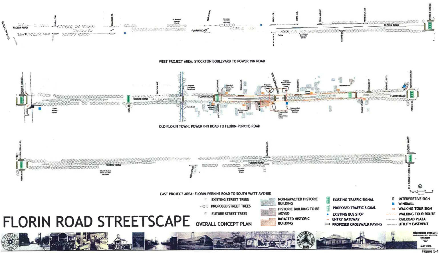
Figure 5-2
Section titled “Figure 5-2”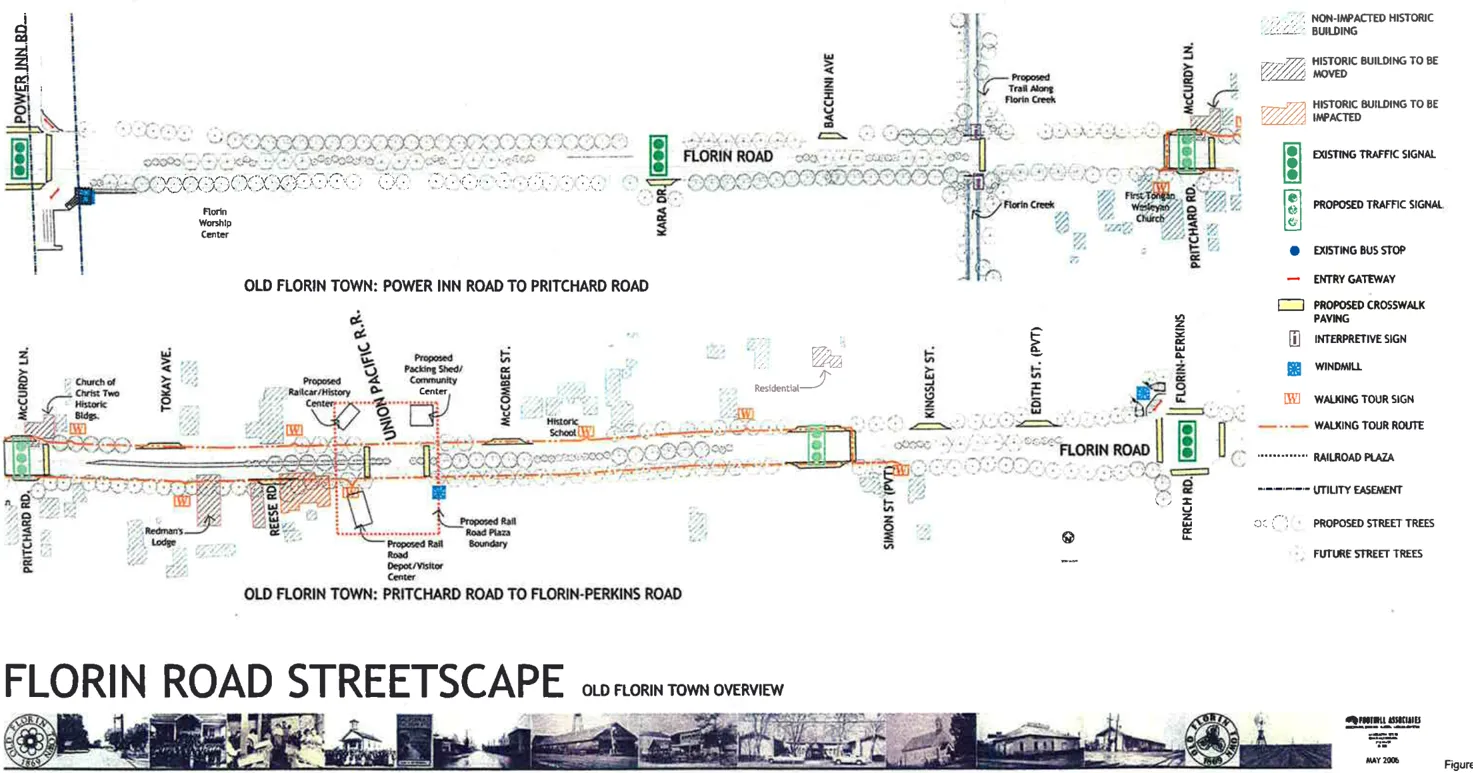
Figure 5-3
Section titled “Figure 5-3”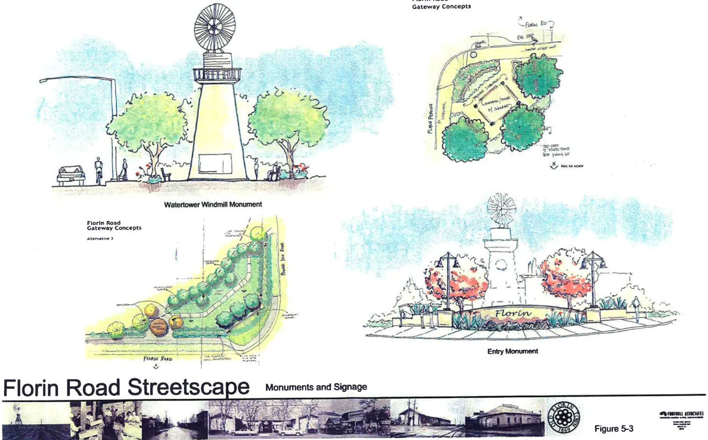
Figure 5-4
Section titled “Figure 5-4”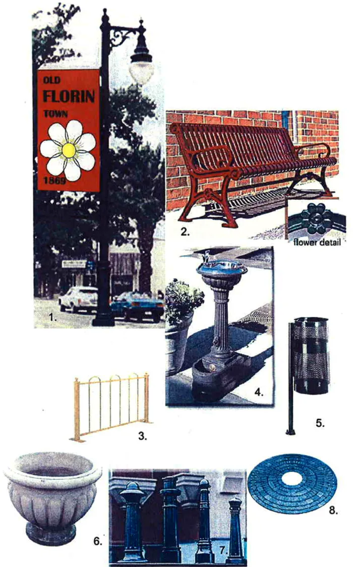
Key:
1. Lighting: Stermberg Lighting, Decatur Pole, banner arm and 1910 Acorn lamp.
2. Bench: Victor Stanley Classic Series bench, Model CR-196.
3. Bicycle Parking: Madrax Gramercy Model CLR5.
4. Drinking Fountain: Olympic 6600 Series, Model 6622.
5. Trash Receptacle: Parking Zone, Pole Trash Receptacle, model SKU: UR*H9N.
6. Planter: Fluted Concrete Planter.
7. Bollard: Olympic Cast Bollard, Model CB-C.
8. Treegrate: Urban Accessories, Cobblestone.
5.3 Phasing of Improvements and Preliminary Cost Estimate
Section titled “5.3 Phasing of Improvements and Preliminary Cost Estimate”The implementation of the Streetscape Master Plan will likely happen in three main phases:
- Improvements to Old Florin Town,
- Improvements to section from Stockton Boulevard to Power Inn Road, and
- Improvements from Florin-Perkins Road to Elk Grove Florin Road.
Due to the need to revitalize the historic district and improve safety along this stretch of the roadway, improvements to Old Florin Town are the highest priority. Street improvements must necessarily be accomplished prior to installing landscaping and improvements, but before street improvements can be made, impacts to historic structures must be resolved by either moving the structures or renovating them to accommodate the widened right-of-way. Once the needed changes are made to the impacted structures, roadway improvements can proceed, including installation of medians, dedicated left-turn lanes, textured cross-walks, additional traffic and bike lanes and sidewalks. It is important to install irrigation sleeves to all medians during roadway construction to avoid having to tear up the roadway when landscape improvements are installed. Once roadway modifications have been completed, planting and furnishings, including street lights, benches and trash receptacles, can be installed.
The next highest priority for improvement is the section from Stockton Boulevard to Power Inn Road. The medians in the westernmost part of this section have been recently landscaped, and continuing these plantings eastward by removing the asphalt in the existing medians, amending soil and replanting would be a relatively low-cost improvement that would significantly improve the aesthetics of this section. Joining the existing section of sidewalk with new walkway and creating planting strips between the sidewalks and roadways could follow median improvements, in addition to installation of streetlights and benches in select locations. Planting of the areas outside of the sidewalks can happen separately from the rest of the streetscape as the County and community encourage individual property owners to plant trees along the right-of-way.
Finally, the section of the streetscape east of Florin-Perkins Road should be constructed. This area is still relatively rural, and streetscape improvements could likely be accomplished as the adjacent land is developed for residential and commercial uses.
Table 5-3 contains an estimate of the costs to implement the Streetscape Master Plan. Because of the variability of the cost to resolve the conflicts with existing structures, these costs are not included in the estimate. The costs shown in the table are in 2006 dollars.
Table 5-3 Cost Estimate for Old Florin Town
Section titled “Table 5-3 Cost Estimate for Old Florin Town”| Item | Quantity | Units | Unit Cost | Cost |
|---|---|---|---|---|
| Site preparation | TBD | SF | TBD | TBD |
| Vehicular Traffic Calming Measures and Signalization | ||||
| Roadway asphalt | TBD | SF | TBD | TBD |
| Curbs | TBD | LF | TBD | TBD |
| Traffic Lights | TBD | EA | TBD | TBD |
| Monuments and Signs | ||||
| Monuments | TBD | EA | TBD | TBD |
| Gateway signs | TBD | EA | TBD | TBD |
| Walking Tour signs | TBD | EA | TBD | TBD |
| Pedestrian Ways and Amenities | ||||
| Sidewalk improvements | TBD | SF | TBD | TBD |
| Raised, Patterned Crosswalks | TBD | SF | TBD | TBD |
| Hardscape, Fences, and Barriers | ||||
| Fencing | TBD | LF | TBD | TBD |
| Street Furniture and Fixtures | ||||
| Cobrahead lights | TBD | EA | TBD | TBD |
| Historic District Lights | TBD | EA | TBD | TBD |
| Benches | TBD | EA | TBD | TBD |
| Trash Receptacles | TBD | EA | TBD | TBD |
| Street Trees and Landscape Planting | ||||
| Irrigation | TBD | SF | TBD | TBD |
| Trees | TBD | EA | TBD | TBD |
| Shrubs | TBD | EA | TBD | TBD |
| Groundcover | TBD | EA | TBD | TBD |
Table 5-4 - Cost Estimate for Stockton Boulevard to Power Inn Road
Section titled “Table 5-4 - Cost Estimate for Stockton Boulevard to Power Inn Road”| Item | Quantity | Units | Unit Cost | Cost |
|---|---|---|---|---|
| Site preparation | TBD | SF | TBD | TBD |
| Vehicular Traffic Calming Measures and Signalization | ||||
| Roadway asphalt | ||||
| Curbs | ||||
| Traffic Lights | ||||
| Monuments and Signs | ||||
| Monuments | ||||
| Gateway signs | ||||
| Walking Tour signs | ||||
| Pedestrian Ways and Amenities | ||||
| Sidewalk improvements | ||||
| Raised, Patterned Crosswalks | ||||
| Hardscape, Fences, and Barriers | ||||
| Fencing | ||||
| Street Furniture and Fixtures | ||||
| Cobrahead lights | ||||
| Historic District Lights | ||||
| Benches | ||||
| Trash Receptacles | ||||
| Street Trees and Landscape Planting | ||||
| Irrigation | ||||
| Trees | ||||
| Shrubs | ||||
| Groundcover |
Table 5-5 – Cost Estimate for Florin-Perkins to Elk Grove Florin
Section titled “Table 5-5 – Cost Estimate for Florin-Perkins to Elk Grove Florin”| Item | Quantity | Units | Unit Cost | Cost |
|---|---|---|---|---|
| Site preparation | TBD | SF | TBD | TBD |
| Vehicular Traffic Calming Measures and Signalization | ||||
| Roadway asphalt | ||||
| Curbs | ||||
| Traffic Lights | ||||
| Monuments and Signs | ||||
| Monuments | ||||
| Gateway signs | ||||
| WalkingToursigns | ||||
| Pedestrian Ways and Amenities | ||||
| Sidewalk improvements | ||||
| Raised, Patterned Crosswalks | ||||
| Hardscape, Fences, and Barriers | ||||
| Fencing | ||||
| Street Furniture and Fixtures | ||||
| Cobrahead lights | ||||
| Historic District Lights | ||||
| Benches | ||||
| Trash Receptacles | ||||
| StreetTrees and Landscape Planting | ||||
| Irrigation | ||||
| Trees | ||||
| Shrubs | ||||
| Groundcover |
APPENDIX: Air Quality Mitigation Plan and Climate Action Plan
Section titled “APPENDIX: Air Quality Mitigation Plan and Climate Action Plan”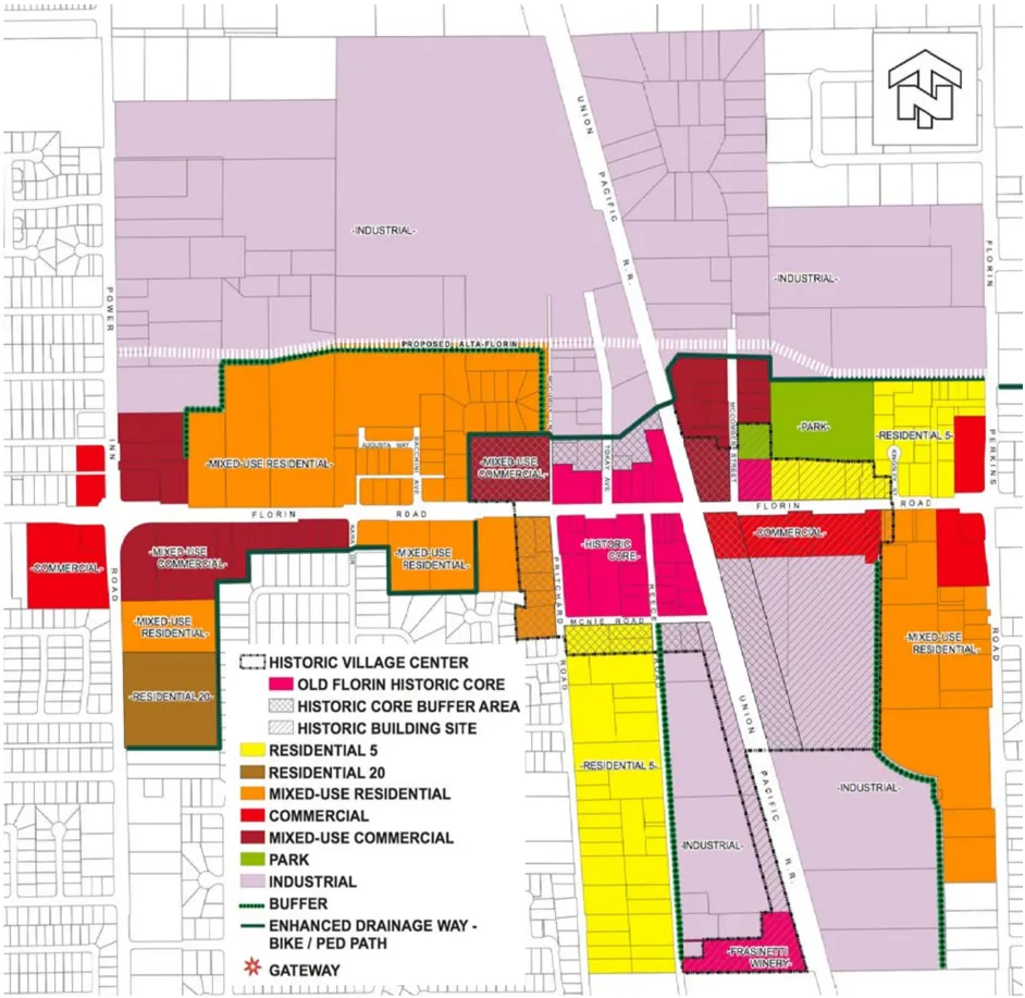
Prepared by: Department of Environmental Review and Assessment 827 7th Street, Room 220 Sacramento, CA 95624

EXECUTIVE SUMMARY
Section titled “EXECUTIVE SUMMARY”The approximately 440 acre Old Florin Town project area is located in central Sacramento County, just south of the city of Sacramento and east of Highway 99. The proposed project site is located along Florin Road between Power Inn Road and Florin Perkins/French Road. Implementation of the proposed project would result in a Special Planning Area (SPA) that would guide the redevelopment of the project site with predominately industrial as well as residential and commercial mixed-uses which is indented both revitalize and preserve the Old Florin Town area.
This document describes mitigation measures that would be implemented to reduce project-generated operational emissions of the ozone precursors (reactive organic gases [ROG] and oxides of nitrogen [NOX]) by 15% in accordance with policies of the Sacramento County General Plan Air Quality Element (General Plan) requiring “a 15 percent reduction in emissions from the level that would be produced by a base-case project assuming full trip generation per the current Institute of Transportation Engineers (ITE) Trip Generation Handbook”(Sacramento County1993) and as recommended by the Sacramento Metropolitan Air Quality Management District (SMAQMD). This plan also meets the requirements of the California Environmental Quality Act (CEQA) that mitigation be implemented to the extent feasible in order to reduce significant adverse environmental impacts. SMAQMD has determined that a 15% reduction in operational emissions of ozone precursors constitutes feasible mitigation.
Mitigation measures found in this document are from the SMAQMD “Recommended Guidance for Land Use Emission Reductions” (SMAQMD 2007). Mitigation measures along with point values being applied to the Old Florin Town SPA can be found in Table AQ-1. Not all measures found in the SMAQMD guidance document are applicable to the project. Only those measures which are to be used are discussed in the following sections of the Operational Air Quality Mitigation Plan (AQMP).
Table AQ-1: Proposed Operational Air Quality Mitigation Plan Summary
Section titled “Table AQ-1: Proposed Operational Air Quality Mitigation Plan Summary”| Bicycle/Pedestrian/Transit Measures | Description | Point Value |
|---|---|---|
| 1. Bicycle parking | Non-residential projects provide plentiful short-term and long-term bicycle parking facilities to meet peak season maximum demand | 0.58 |
| 5. Pedestrian network | The project provides a pedestrian access network that internally links all uses and connects to all existing or planned external streets and pedestrian facilities contiguous with the project site | 1 |
| 9. Traffic calming | Project design includes pedestrian/bicycle safety and traffic calming measures in excess of jurisdiction requirements. Roadways are designed to reduce motor vehicle speeds and encourage pedestrian and bicycle trips by featuring traffic calming features. | 1 |
| Mixed-use Measures | Description | Point Value |
|---|---|---|
| 23. Suburban mixed-use | Have at least three of the following on site and/or offsite within ¼ mile: Residential Development, Retail Development, Park, Open Space, or Office | 3 |
| 31. Non-roof surfaces | Provide shade (within 5 years) and/or use light- colored/high-albedo materials (reflectance of at least 0.3) and/or open grid pavement for at least 30% of the site’s non-roof impervious surfaces, including parking lots, walkways, plazas, etc.; OR place a minimum of 50% of parking spaces underground or covered by structured parking; OR use an open-grid pavement system (less than 50% impervious) for a minimum of 50% of the parking lot area. Unshaded parking lot areas, driveways, fire lanes, and other paved areas have a minimum albedo of .3 or greater | 1 |
| Other Measures | Description | Point Value |
|---|---|---|
| 99A. Parking reduction requirement | The parking standards of the Old Florin Town SPA shall allow for greater flexibility in the provision of parking and reduce the negative impacts of excessive parking | 3 |
| 99B. Community parking lots | Project proposes community parking areas to the rear of buildings strategically interspersed throughout the project site. These ‘Pocket Lots’ will be shaded and have pedestrian connectivity to structures in the vicinity and be apart of the pedestrian network proposed for the project. | 4 |
| 99C. Excluding high VOC emitting trees | All new development or redevelopment shall exclude the highest VOC emitting trees (goldenrain trees and California live oak trees) from all landscape and mitigation tree planting plans within the project area. | 0.5 |
| 99D. Strategic planting of trees | Project proposes landscaping that maximizes shade in the summer and maximizes sol ar access to walls and windows in the winter. | 1 |
| Totals and Target | Point Value |
|---|---|
| Total Credit | 15.08 |
| Emissions Reduction Target | 15.00 |
Source: SMAQMD 2007. Data Complied by DERA 2009.
The Old Florin Town SPA focuses primarily on the redevelopment of an existing developed, aging area with mixed-use commercial and industrial development. The project includes several smart growth strategies which include providing a mix of transportation options including walkable paths and bike lanes; providing for mixed-use development with multiple uses in one building or a blend of multiple uses throughout a development rather than grouping similar uses; directing development towards existing communities by building on infill land and urban brown fields; creating a sense of place and creating a distinctive and attractive community while preserving open space. These and other smart growth strategies inherently lend to improved air quality.
The ultimate purpose of smart growth is sustainable communities, and is a reaction in part to the recognized health impacts of urban sprawl and vehicle-centric development strategies. Various studies have demonstrated that smart growth development significantly reduces impacts to air quality, water quality, open space/biological resources, and public health. A 2005 Seattle study found that residents of neighborhoods where land uses were mixed and streets are better connected, making non-auto travel easier and more convenient, traveled 26 percent fewer vehicle mile than residents of neighborhoods that were more dispersed and less connected (Lawrence Frank and Company). It has also been demonstrated that the greenhouse gas emission reductions incorporated within California’s Executive Order S-3-05 are unlikely to be achieved just through vehicle efficiency and development of low-carbon fuels – significant vehicle trip reductions will also be required (Yang, et. al.) and can be fostered through smart growth land use policies.
The Old Florin Town SPA includes the smart growth elements noted above and is expected to have an overall benefit to air quality. In addition, the measures noted in the table above are intended to reduce air quality impacts by further supporting smart growth principles by increasing pedestrian mobility throughout the plan area and the surrounding communities, decreasing the number of vehicle trips to and within the project area, increasing pedestrian safety and comfort and providing a mix of uses in one area to meet community needs.
INTRODUCTION
Section titled “INTRODUCTION”The Sacramento County Planning and Community Development Department is proposing to adopt the Old Florin Town SPA. Sacramento County prepared this SPA to help protect and preserve the charm and history of the Old Florin Town area along Florin Road between Power Inn Road and Florin Perkins Road. The SPA is intended to accomplish this by focusing on the preservation of the Historic Village Center, re-designating land for housing opportunities and creating a theme for the area with specific development standards and design guidelines.
The purpose of this document is to identify recommended measures to mitigate the operational pollutant (ozone precursors ROG and NOx) emissions associated with the proposed land uses that could occur in the Old Florin Town Plan area by at least 15%. This document has been prepared in accordance with SMAQMD’s recommendations and with Policy AQ-15 of the Sacramento County General Plan Air Quality Element.
- AQ-15: All new major indirect sources of emissions shall be reviewed and modified or conditioned to achieve a reduction in emissions. This indirect source review program will be developed in coordination with SACOG and SMAQMD, and include the following features;
- A 15% reduction in emissions from the level that would be produced by a base-case project assuming full trip generation per the current ITE Trip Generation Handbook.
The following sections of this document detail the proposed project’s existing and planned transportation setting and the proposed Land Use Emission Reduction mitigation measures for the project as directed by the SMAQMD’s Recommended Guidance for Land Use Emission Reductions (SMAQMD 2007). The emission reduction measures are organized into the following categories:
- Bicycle/Pedestrian/Transit Measures;
- Mixed Use Measures;
- Other Measures
PROJECT DESCRIPTION AND SETTING
Section titled “PROJECT DESCRIPTION AND SETTING”The Old Florin Town SPA site is located in the South Sacramento community along Florin Road generally between Power Inn and Florin Perkins/ French Roads (refer to Plate AQ-1). The purpose of the proposed plan is to guide the revitalization and enhancement of the Old Florin Town area by preserving the historic nature of the site and providing flexibility for applicants during the development process while simultaneously providing specific guidelines and standards for future development that will result in new development that reflects the historic character of the community (refer to Table AQ-2for land use summaries).
Table AQ-2: Land Use Summary and Scale Factors
Section titled “Table AQ-2: Land Use Summary and Scale Factors”| General Land Use Categories | Acres | Residential | Commercial | Industrial | Open Space/ Park | Mixed-Use |
|---|---|---|---|---|---|---|
| Low Density Residential | 23.0 | 100% | 0% | 0% | 0% | 0% |
| Mixed Use Residential | 87.3 | 80% | 20% | 0% | 0% | 100% |
| Mixed Use Commercial | 62.3 | 40% | 60% | 0% | 0% | 100% |
| Intensive Industrial | 260.2 | 0% | 0% | 100% | 0% | 0% |
| Recreation | 7.30 | 0% | 0% | 0% | 100% | 0% |
| Total Acreage | 440.1 | 117.76 | 54.84 | 260.20 | 7.30 | 149.60 |
| %of project (total) | 26.72% | 12.46% | 59.12% | 1.65% | 33.99% | |
| %of Project (Developed for Urban Purposes) | 432.80 | 27.20% | 12.67% | 60.12% | 0% | 100 (Sub % urban) |
| Total non-residential only a nd non- recreation uses | 409.7 (93.09%) |
Notes: The Recommended Guidance for Land Use Reductions document explains as a footnote on the bottom of page 8 that the total net area of a project site should exclude land designated for undeveloped open space. The Scale Factor utilized in determining mitigation measure values were computed assuming that only 432.80 acres are developed for urban purposes (netting out the recreation portion of the project, which would have minimum associated trip generation and operational emissions). Source: SMAQMD 2007
Plate AQ-1: Project Location Map
Section titled “Plate AQ-1: Project Location Map”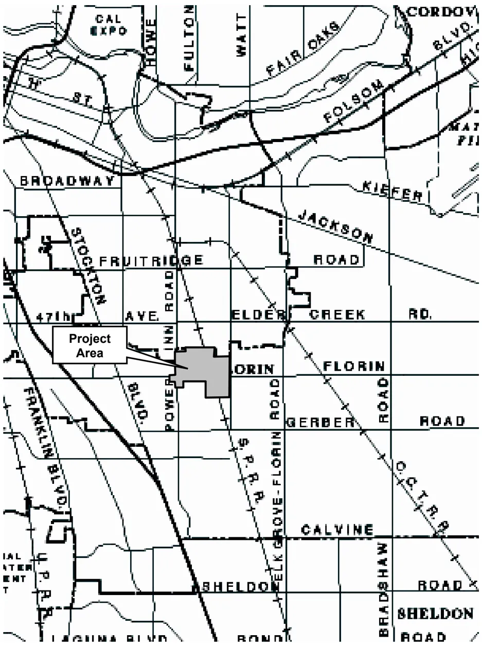
ACCESS CHARACTERISTICS
Section titled “ACCESS CHARACTERISTICS”The Old Florin Town area is located along Florin Road which is a major roadway in Sacramento County. Florin Road bisects the plan area and provides access to the site from the east and west. In addition to this roadway Power Inn Road and Florin Perkins/ French Road provide access to the site from the north and south. Power Inn Road is located adjacent to the west side of the project area and provides access directly to Florin Road as well as a number of other smaller roadways in the project area. Florin Perkins/ French Road is adjacent to the east side of the project area, provides direct access to Florin Road and also provides access to a number of smaller roadways in the project area. In addition to these more major roadways, many other smaller roadways extend into the plan area or near the plan area from the adjacent communities that surround the site. Most notably, Kara Drive, Prichard Road, Reese Road and Danridge Drive extend into the site or near the site boundaries from the surrounding development.
BICYCLE FACILITIES
Section titled “BICYCLE FACILITIES”EXISTING BICYCLE SYSTEM/ PEDESTRIAN NETWORK
Section titled “EXISTING BICYCLE SYSTEM/ PEDESTRIAN NETWORK”The Old Florin Town SPA area is located directly between two Class II bike lanes which extend into the existing communities to the south. Currently Class II bike lanes are located south of Florin Road along Power Inn Road along the west side of the project site and along French Road to the east. These bike lanes have direct contact with the SPA area and allow for pedestrian connectivity to Gerber Road. In addition to these lanes that have direct connectivity to the project area, several additional bicycle lanes are within one half mile of the project site. Class II bike lanes are located along Power Inn Road just northwest of the project site which extend to within the City of Sacramento. Class II bike lanes are also located along Briggs Drive which extend from Florin Road to 53 rd Street. Lastly, the Florin Creek Bike Trail, which contains a Class I bike path, is located just west of the project site beginning at Palmer House Drive. The bike trail, as it heads west, connects with Stockton Boulevard, which has Class II bike lanes running along its length, and ends at Sheldon Park near Highway 99 (refer to Plate AQ-2).
Plate AQ-2: Existing Bicycle F acilities
Section titled “Plate AQ-2: Existing Bicycle F acilities”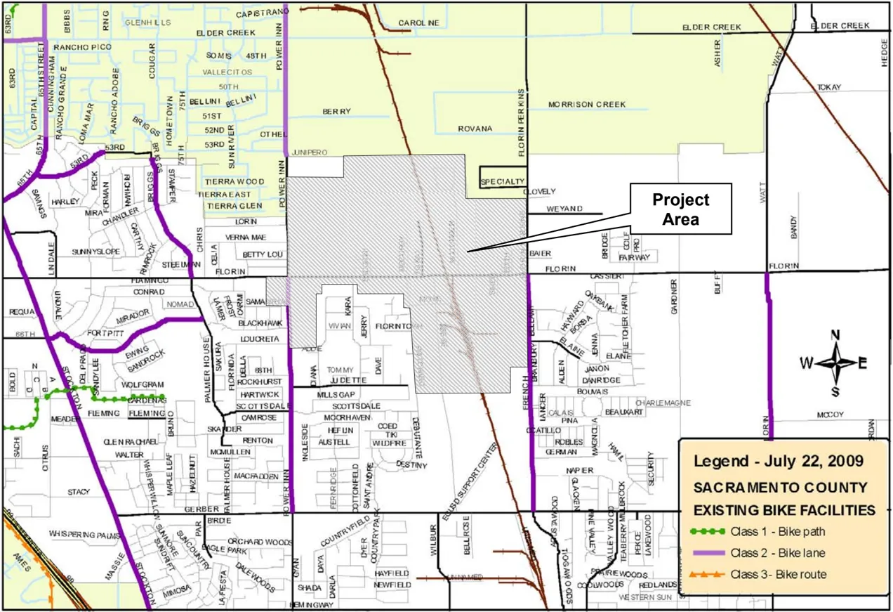
PROPOSED BICYCLE AND PEDESTRIAN NETWORK
Section titled “PROPOSED BICYCLE AND PEDESTRIAN NETWORK”As stated in the Old Florin Town SPA Plan, pedestrian facilities within the plan area are expected to be developed as the site builds out. The plan states, in Section 505-619d, that all industrial projects in the SPA with property boundaries contiguous to a road or street shall provide sidewalks in accordance to Sacramento County standards.
In addition to the site being located immediately adjacent to two bike lanes and being within one half mile of several others, the Plan includes an enhanced drainage way which is to be located along Florin Creek. The enhanced drainage way is planned to extend through the project site from Power Inn Road to the west to Florin Perkins/French Road to the east and will cross Florin Road just west of Prichard Road and provide pedestrian access through the site. The parcels along the drainage way are required to provide a 20 foot wide setback and easement to allow for a pedestrian and bicycle pathway that will be located within the drainage way. Approximately 50 parcels within the plan area are located adjacent to this proposed drainage way and the drainage way connects with the primary roadways in the SPA area and crosses a number of others (Refer to Plate AQ-3).
Aside form pedestrian improvements related to the OFT SPA, the Florin area adjacent to and within the project site is planned to contain other pedestrian amenities that are to be developed through other projects. One of these endeavors is the Old Florin Town Streetscape Master Plan.
The purpose of this Streetscape Master Plan is to provide a basis for decisions and actions that will lead to improved aesthetics and pedestrian safety along Florin Road between Stockton Boulevard to Elk Grove-Florin Road. The primary intent of this Maser Plan is to provide guidelines in the areas of landscape improvements to medians and frontages, sidewalks, pavement (including crosswalks), decorative street lighting, bikeways, and other accessibility enhancements to aid in the revitalization and renovation of existing residences and business as well as new development along Florin Road. The Master Plan emphasizes pedestrian friendly development along Florin Road, including the portion of Florin Road within the project area, and includes strategies to install six foot wide separated sidewalks, develop Class II bike lanes, utilize traffic calming measures and require street trees and landscape plantings among others.
Plate AQ-3: Enhanced Drainage Way
Section titled “Plate AQ-3: Enhanced Drainage Way”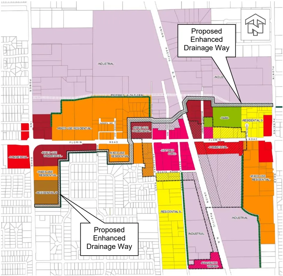
PROPOSED MEASURES
Section titled “PROPOSED MEASURES”The following supporting text and exhibit references detail mitigation measures that would reduce air pollutant emissions from development related land uses. The text describes how measures would be implemented in accordance with the information available at this time. Additional information may be available when redevelopment occurs.
BICYCLE/ PEDESTRIAN/ TRANSIT MEASURES
Section titled “BICYCLE/ PEDESTRIAN/ TRANSIT MEASURES”MEASURE 1: BIKE PARKING
Section titled “MEASURE 1: BIKE PARKING”Unscaled SMAQMD emissions reduction = 0.625
Scale factor = .93 (commercial and mixed-use)
Scaled mitigation value = 0.58
All new and redeveloped commercial, industrial and mixed use projects in the plan area shall provide secure, easily accessible, bicycle racks or lockers adjacent to facility entryways. Short term bicycle parking facilities shall be provided at a minimum ratio of one bicycle space per 20 vehicle spaces. Long term facilities shall be provided at a minimum ratio of one long term bicycle space per 20 employee parking spaces.
MEASURE 5: PEDESTRIAN NETWORK
Section titled “MEASURE 5: PEDESTRIAN NETWORK”Unscaled SMAQMD emissions reduction = 1.00
Scale factor = 1 (entire project)
Scaled mitigation value = 1.00
The project proposes an enhanced drainage way that extends through the project site from Power Inn Road to Florin Perkins/French Road and crosses Florin Road just west of Prichard Road (refer to Plate AQ-3). The parcels along the drainage way are required to provide a 20 foot wide setback and easement to allow for a pedestrian and bicycle pathway throughout the site. The pedestrian pathway will have connectivity with Power Inn Road where an existing Class II bikeway is located and is located within ½ mile of a number of other Class II bike lanes in the area (refer to Plate AQ-2). In addition the proposed pathway will connect with Florin Perkins Road which is planned to have Class II bike lanes according to the 2010 bikeway master plan.
All new development or redevelopment in the plan area shall include shaded and lighted pedestrian access routes connecting from the development to either Florin Road, Power Inn Road, Florin Perkins/French Road, the proposed enhanced drainage way or other existing pedestrian access route that already connects to the above mentioned routes, creating a network of interconnected pedestrian paths throughout the plan area.
MEASURE 9: TRAFFIC CALMING
Section titled “MEASURE 9: TRAFFIC CALMING”Unscaled SMAQMD emissions reduction = 0.25- 1.0
Scale factor = 1 (entire project)
Scaled mitigation value = 1
All sidewalks internal and adjacent to the project site shall be a minimum of five feet wide and have vertical curbs and all intersections shall meet at right angles. All intersections internal and adjacent to the project site shall include at least one of the following features: marked crosswalks, count-down signal timers, speed tables, raise crosswalks or raised intersections. d
MIXED-USE MEASURES
Section titled “MIXED-USE MEASURES”USE MEASURE 23: SUBURBAN MIXED
Section titled “USE MEASURE 23: SUBURBAN MIXED”Unscaled SMAQMD emissions reduction = 3.0
Scale factor = 1 (entire project)
Scaled mitigation value = 3.00
The Plan proposes mixed use residential, mixed use commercial as well as park, commercial and residential uses all within the plan area. One of the primary focuses of the SPA is re-designating land to provide for additional housing opportunities.
The Plan calls for the development of greater densities in the plan area over what is currently allowed effectively situating more residences alongside mixed use, commercial ill allow for approximately 740 new residences the opportunity for people to be living near and industrial uses. Overall, the Plan w within the plan area which can provide employment opportunities.
MEASURE 31: NON-ROOF SURFACE
Section titled “MEASURE 31: NON-ROOF SURFACE”Unscaled SMAQMD emissions reduction = 1.0
Scale factor = 1 (entire project)
Scaled mitigation value = 1.00
In order to reduce the heat island effect that can be produced from developed areas, all new development or redevelopment shall provide one or any combination of the following strategies: Provide shade for 50% of the site hardscape within 15 years. Utilize paving materials with a solar reflective index of at least 29 for 50% of site hardscape. Utilize an open grid pavement system of 50% of site hard scape.
OTHER MEASURES
Section titled “OTHER MEASURES”MEASURE 99A: PARKING REDUCTION REQUIREMENT
Section titled “MEASURE 99A: PARKING REDUCTION REQUIREMENT”Unscaled SMAQMD emissions reduction = 3.0
Scale factor = 1 (entire project)
Scaled mitigation value = 3.0
The project plan indicates that individual projects will be allowed to provide parking to a currently allowed by the zoning code. lesser standard than what is the allow for 50% of all parking generated by new development or redevelopment to be accommodated through a shared parking strategy. The parking standards of the Old Florin Town SPA shall allow for greater flexibility in provision of parking and reduce the negative impacts of excessive parking. The plan shall limit parking for all new development and redevelopment to no more than the minimum required by code as calculated at the time development projects are proposed. In addition, the plan shall
MEASURE 99B: COMMUNITY PARKING LOTS
Section titled “MEASURE 99B: COMMUNITY PARKING LOTS”Unscaled SMAQMD emissions reduction = 4.0
Scale factor = 1 (entire project)
Scaled mitigation value = 4.0
In addition to requiring that parking be provided at reduced levels, the plan also calls for g elp create a pedestrian friendly environment and to aid pedestrian access throughout the k the creation of ‘Pocket Lots’ which are small (30 spaces or less) community parkin areas that are to be strategically interspersed throughout the plan area. The Pocket Lots shall be developed with perimeter sidewalks and shade trees in order to h plan area. The perimeter sidewalks shall be apart of the plan area pedestrian network to facilitate pedestrian mobility throughout the site.
The small community parking areas, which will be no larger than 30 spaces each, shall be developed throughout the plan area to accommodate the spaces needed for the shared parking strategy noted above. In all, the community parking areas shall be developed to accommodate 50% all parking generated by new development or redevelopment.
MEASURE 99C: EXCLUDING HIGH VOC EMITTING TREES
Section titled “MEASURE 99C: EXCLUDING HIGH VOC EMITTING TREES”Unscaled SMAQMD emissions reduction = 0.5
Scale factor = 1 (entire project)
Scaled mitigation value = .05
All new development or redevelopment shall exclude the highest VOC emitting trees (goldenrain trees and California live oak trees) from all landscape and mitigation tree planting plans within the project area.
MEASURE 99D: STRATEGIC PLANTING OF TREES
Section titled “MEASURE 99D: STRATEGIC PLANTING OF TREES”Unscaled SMAQMD emissions reduction = 1.0
Scale factor = 1 (entire project)
Scaled mitigation value = 1.00
Landscaping for newly developed or redeveloped properties shall include plantings of trees or other landscaping features which are sited in such a way as to maximize shade in the summer and maximize solar access to walls and windows in the winter.
REFERENCES
Section titled “REFERENCES”County of Sacramento, Department of Planning & Community Development. ‘Old Florin Town Special Planning Area’ May, 22, 2007 (draft).
‘How Land Use and Transportation Systems Impact Public Health: A Literature Review of the Relationship Between Physical Activity and Built Form’ Lawrence D. Frank. PhD and Mr. Peter Engelke. City and Regional Planning Program College of Architecture Georgia Institute of Technology
‘Identifying Options for Deep Reductions in Greenhouse Gas Emissions from California Transportation: Meeting an 80% Reduction Goal in 2050 Full Report including Policymaker Summary and Appendix’ Christopher Yang, David McCollum, Ryan McCarthy, Wayne Leighty. University of California at Davis, One Shields Avenue · Davis, California.
Klinker, Dan. ‘Old Florin Town Existing Bikeways.’ E-mail to Kevin Messerschmitt. 22 July. 2009.
Sacramento Metropolitan Air Quality Management District, ‘Recommended Guidance for Land Use Emissions Reductions, Version 2.4’ August 15, 2007.
APPENDIX: Mitigation, Monitoring, and Reporting Program Measures
Section titled “APPENDIX: Mitigation, Monitoring, and Reporting Program Measures”PS-1: Public Service Infrastructure
Section titled “PS-1: Public Service Infrastructure”Prior to Development Plan Review or issuance of building permits for projects resulting in intensification of use or increased square footage associated with development pursuant to the Old Florin Town Special Planning Area Ordinance, the Sacramento County Municipal Services Agency (MSA) shall prepare, or facilitate the preparation of, a phasing plan that identifies thresholds of development for when necessary improvements are required. The phasing plan shall also identify a mechanism to track when thresholds are met so infrastructure improvements are constructed when needed.
If private applicants/developers wish to proceed with development ahead of MSA’s phasing plan, project specific analyses (i.e. sewer study, water study, traffic study) will be required to ensure that the existing infrastructure can accommodate the proposed development. Infrastructure improvements that are needed to accommodate proposed development shall be constructed prior to issuing building permits.
TC-1: Traffic and Circulation
Section titled “TC-1: Traffic and Circulation”Prior to Development Plan Review or issuance of building permits for projects resulting in intensification of use or increased square footage associated with development pursuant to the Old Florin Town Special Planning Area Ordinance, the Sacramento County Municipal Services Agency (MSA) shall prepare, or facilitate the preparation of, a phasing plan that identifies thresholds of development for when necessary improvements are required. The phasing plan shall also identify a mechanism to track when thresholds are met so infrastructure improvements are constructed when needed.
If private applicants/developers wish to proceed with development ahead of MSA’s phasing plan, project specific analyses (i.e. sewer study, water study, traffic study) will be required to ensure that the existing infrastructure can accommodate the proposed development. Infrastructure improvements that are needed to accommodate proposed development shall be constructed prior to issuing building permits.
The following improvements shall be installed:
- At the Florin Road/Power Inn Road intersection, add a second eastbound left turn lane. The project’s fair share responsibility is 100% of the estimated improvement cost.
- At the Florin Road/Florin Perkins Road intersection, add a second eastbound left turn lane. The project’s fair share responsibility is 100% of the estimated improvement cost.
- Widen Power Inn Road from Elder Creek Road to the City of Sacramento Limit to 4 lanes. The project’s fair share responsibility is 100% of the estimated improvement cost.
- At the Florin Road/Power Inn Road intersection, install two left turn lanes, three through lanes and exclusive right turn lane of the westbound approach. The project’s fair share responsibility is 2% of the estimated improvement cost.
AQ-1: Construction Ozone Precursor Emissions and Diesel Particulates
Section titled “AQ-1: Construction Ozone Precursor Emissions and Diesel Particulates”Development proposals that exceed the SMAQMD NOX screening levels shown in Table AQ-2, or any similar screening standard adopted by SMAQMD at the time of project application, shall be required to prepare construction emission estimates based on projected construction timelines and equipment lists prior to approval of improvement plans. When emissions exceed the SMAQMD construction thresholds of significance of 85 pounds per day of NOX, or the applicable standard in place at the time of application, the following measure shall be implemented:
The project shall ensure that emissions from all off-road diesel powered equipment used on the project site do not exceed 40 percent opacity for more than three minutes in any one hour. Any equipment found to exceed 40 percent opacity (or Ringelmann 2.0) shall be repaired immediately, and SMAQMD shall be notified within 48 hours of identification of non-compliant equipment. A visual survey of all in-operation equipment shall be made at least weekly, and a monthly summary of the visual survey results shall be submitted throughout the duration of the project, except that the monthly summary shall not be required for any 30-day period in which construction activity does not occur. The monthly summary shall include the quantity and type of vehicles surveyed as well as the dates of each survey. The SMAQMD and/or other officials may conduct periodic site inspections to determine compliance;
and,
The contractor shall provide a plan for approval by SMAQMD demonstrating that the heavy-duty (> 50 horsepower) off-road vehicles to be used in the construction project, including owned, leased and subcontractor vehicles, will achieve a project wide fleetaverage 20 percent NOX reduction and 45 percent particulate reduction compared to the most recent CARB fleet average at time of construction; and the project sponsor shall submit to SMAQMD a comprehensive inventory of all off-road construction equipment, equal to or greater than 50 horsepower, that will be used an aggregate of 40 or more hours during any portion of the construction project. Acceptable options for reducing emissions may include use of late model engines, low-emission diesel products, alternative fuels, engine retrofit technology, after-treatment products, and/or other options as they become available. The inventory shall include the horsepower rating, engine production year, and projected hours of use or fuel throughput for each piece of equipment. The inventory shall be updated and submitted monthly throughout the duration of the project, except that an inventory shall not be required for any 30-day period in which no construction activity occurs. At least 48 hours prior to the use of subject heavy-duty off-road equipment, the project representative shall provide SMAQMD with the anticipated construction timeline including start date, and name and phone number of the project manager and on-site foreman.
If, after the 20 percent NOX reduction afforded by implementation of the above, the SMAQMD thresholds of significance are still exceeded, then that development shall pay SMAQMD off-site air quality mitigation fees to reduce the project’s net construction NOX emissions below the significance threshold. The off-site mitigation fees shall be paid to SMAQMD prior to the approval of improvement plans or the issuance of grading permits. Developers should contact the SMAQMD for assistance in assessing the fee, based on the current rate of $16,000/ton of NOX or the prevailing rate in effect at the time of construction.
Table AQ-2: SMAQMD Construction Screening Levels
Section titled “Table AQ-2: SMAQMD Construction Screening Levels”| Land Use Development Type | Construction Screening Level |
|---|---|
| Single Family Residential | 180 units |
| Apartments - Low Rise | 980 units |
| Apartments - Mid Rise | 1,895 units |
| Apartments - High Rise | 2,100 units |
| Condo/Townhouse General | 960 units |
| Condo/Townhouse High Rise | 2,100 units |
| Mobile Home Park | 360 units |
| Retirement Community | 305 units |
| Congregate Care Facility | 960 units |
| Day-Care Center, Elementary School, Junior high School, High School | 1,307 k square feet |
| Junior College | 1,307 k square feet |
| 14,205 students | |
| University/College (4 years) | 14,205 students |
| Library | 1,307 k square feet |
| City Park | 60 acres |
| Racquet Club | 1,307 k square feet |
| High Turnover Restaurant | 1,307 k square feet |
| Hotel | 2,614 rooms |
| Regional Shopping Center | 1,307 k square feet |
| Home Improvement Superstore | 1,307 k square feet |
| Strip Mall | 1,307 k square feet |
| Supermarket | 1,307 k square feet |
| Convenience Market with gas pumps | 1,307 k square feet |
| General Office Building, Office Park | 1,307 k square feet |
| Medical Office Building | 1,307 k square feet |
| Hospital | 1,307 k square feet |
| 1,590 beds | |
| Warehouse, Manufacturing, Industrial Park | 625,000 square feet |
| General Light Industry | 625,000 square feet |
| 29 acres | |
| 1,280 employees |
Source: SMAQMD Guide to Air Quality Assessment in Sacramento County, http://www.airquality.org/ceqa/CEQAFAQ.pdf Screening level is based on either ROG or NO X threshold of 65 lbs./day, whichever is achieved first.
AQ-2: Operational Emissions
Section titled “AQ-2: Operational Emissions”All development projects within the OFT SPA shall comply with the SMAQMD endorsed Old Florin Town SPA Operational Air Quality Mitigation Plan (09/28/2009), which requires implementation of reduction measures that will achieve a minimum of 15 percent reduction in operational and area source emissions, consistent with General Plan Policy. The AQMP shall be incorporated into the Old Florin Town SPA.
AQ-3: Sensitive Land Uses Adjacent to Union Pacific Rail Line
Section titled “AQ-3: Sensitive Land Uses Adjacent to Union Pacific Rail Line”Future applicants of projects that have sensitive land uses, within 500 feet of the UP rail line, shall develop a mitigation plan to reduce impacts associated with toxic air contaminants, in consultation with SMAQMD. The mitigation plan may include measures such as vegetative plantings, the installation of electrostatic filters, and/or site redesign.
NO-1: Traffic Noise Impacts to Residential Uses: Interior
Section titled “NO-1: Traffic Noise Impacts to Residential Uses: Interior”To ensure compliance with General Plan Noise Element standards of 45 dB Ldn or less for residential interiors, the following measure shall apply:
- Any/all new residential construction shall be located at or beyond the 70 dB noise contour, as indicated in Tables NS-6 through NS-12 of the EIR.
Any departure or deviation from the above measure must be accompanied by an acoustical analysis, prepared by a qualified acoustical consultant and verified by the Department of Environmental Review and Assessment, substantiating that the General Plan Noise Element standard cited above is met.
Table NS-6: Power Inn Road: Elder Creek to Florin Road Noise Contours
Section titled “Table NS-6: Power Inn Road: Elder Creek to Florin Road Noise Contours”| Lan Contour, dB | Distance from Centerline, (ft) |
|---|---|
| 75 | 44 |
| 70 | 94 |
| 65 | 203 |
| 60 | 437 |
Table NS-7: Power Inn Road: Florin Road to Gerber Road Noise Contours
Section titled “Table NS-7: Power Inn Road: Florin Road to Gerber Road Noise Contours”| Lan Contour, dB | Distance from Centerline, (ft) |
|---|---|
| 75 | 40 |
| 70 | 86 |
| 65 | 184 |
| 60 | 397 |
Table NS-8: Florin Road:Power Inn Road toKara Drive Noise Contours
Section titled “Table NS-8: Florin Road:Power Inn Road toKara Drive Noise Contours”| Lan Contour, dB | Distance from Centerline, (ft) |
|---|---|
| 75 | 39 |
| 70 | 85 |
| 65 | 183 |
| 60 | 394 |
Table NS-9: Florin Road: Kara Drive to Florin-Perkins Road Noise Contours
Section titled “Table NS-9: Florin Road: Kara Drive to Florin-Perkins Road Noise Contours”| Lan Contour, dB | Distance from Centerline, (ft) |
|---|---|
| 75 | 38 |
| 70 | 82 |
| 65 | 176 |
| 60 | 380 |
Table NS-10: Alta Florin Road: Power Inn Road to Florin Perkins Road Noise Contours
Section titled “Table NS-10: Alta Florin Road: Power Inn Road to Florin Perkins Road Noise Contours”| Lan Contour, dB | Distance from Centerline, (ft) |
|---|---|
| 75 | 40 |
| 70 | 85 |
| 65 | 184 |
| 60 | 397 |
Table NS-11: Florin-Perkins Road: Elder Creek Road to Florin Road Noise Contours
Section titled “Table NS-11: Florin-Perkins Road: Elder Creek Road to Florin Road Noise Contours”| Lan Contour, dB | Distance from Centerline, (ft) |
|---|---|
| 75 | 40 |
| 70 | 87 |
| 65 | 188 |
| 60 | 404 |
Table NS-12: French Road: Florin Road to Gerber Road Noise Contours
Section titled “Table NS-12: French Road: Florin Road to Gerber Road Noise Contours”| Lgn Contour, dB | Distance from Centerline, (ft) |
|---|---|
| 75 | 28 |
| 70 | 60 |
| 65 | 130 |
| 60 | 279 |
Table NS-13: Estimated Daily Operations and Distances to Railroad Contours
Section titled “Table NS-13: Estimated Daily Operations and Distances to Railroad Contours”| Daily Operations | Without Horn | With Horn |
|---|---|---|
| 20 | 217 | 467 |
| 25 | 252 | 542 |
| 30 | 284 | 612 |
| 35 | 315 | 679 |
| 40 | 344 | 742 |
Distance to be 65 dB Ldn (feet)
NO-2: Traffic Noise Impacts to Non-Residential Uses: Interior
Section titled “NO-2: Traffic Noise Impacts to Non-Residential Uses: Interior”To ensure compliance with General Plan Noise Element standards for nonresidential interiors, as indicated in Table I of the Sacramento County General Plan (Table NS-3 of this EIR), the following measure shall apply:
- Any/all new non-residential construction shall remain outside the 60 to 75 dB contour, as applicable, assuming a 25 dB standard construction reduction, unless sound resistant construction materials are utilized such that interior noise levels do not exceed the applicable noise level standards per Table NS-3 of this EIR.
Any departure or deviation from the above measure must be accompanied by an acoustical analysis, prepared by a qualified acoustical consultant and verified by the Department of Environmental Review and Assessment, substantiating that the General Plan Noise Element standard cited above is met.
Table NS-3: Noise Standards for New Uses Affected by Traffic and Railroad Noise (Table 1 from the Sacramento County General Plan, Noise Element)
Section titled “Table NS-3: Noise Standards for New Uses Affected by Traffic and Railroad Noise (Table 1 from the Sacramento County General Plan, Noise Element)”| New Land Use | Sensitive [1] Outdoor Area - Ldn | Sensitive [2] Interior Area - Ldn | Notes |
|---|---|---|---|
| All Residential | 65 | 45 | 5 |
| Transient Lodging | 65 | 45 | 3,5 |
| Hospitals & Nursing Homes | 65 | 45 | 3,4,5 |
| Theaters & Auditoriums | - | 35 | 3 |
| Churches, Meeting Halls | 65 | 40 | 3 |
| Schools, Libraries, etc. | 65 | 40 | 3 |
| Office Buildings | 65 | 45 | 3 |
| Commercial Buildings | - | 50 | 3 |
| Playgrounds, Parks, etc. | 70 | - | - |
| Industry | 65 | 50 | 3 |
Notes:
1. Sensitive areas are defined in acoustic terminology section.
2. Interior noise level standards are applied within noise-sensitive areas of the various land uses, with windows and doors in the closed positions.
3. Where there are no sensitive exterior spaces proposed for these uses, only the interior noise level standard shall apply.
4. Hospitals are often noise-generating uses. The exterior noise level standards for relaxation by either hospital staff or patients.
5. If this use is affected by railroad noise, a maximum (Lmax) noise level standard of 70 dB shall be applied to all sleeping rooms to reduce the potential for sleep disturbance during nighttime train passages.
NO-3: Railroad Noise-Residential Receptor: Interior Noise Levels
Section titled “NO-3: Railroad Noise-Residential Receptor: Interior Noise Levels”To ensure compliance with General Plan Noise Element standards for interior noise levels at sensitive residential receptors subjected to railroad noise, the following policy shall be added to the SPA:
- No use shall be operated or constructed that would result in interior noise levels at sensitive residential receptors that exceed the General Plan Noise Element noise standards. Proponents applying for sensitive uses in close proximity to the Union Pacific Rail Road shall submit a noise analysis substantiating compliance with interior noise standards of the General Plan Noise Element noise standards.
NO-4: Community Generated Noise
Section titled “NO-4: Community Generated Noise”To ensure compliance with General Plan Noise Element standards for nontransportation sources, the following policy shall be added to the SPA:
- No use shall be operated so as to generate recurring noises that are unreasonably loud or create a nuisance to any person of ordinary sensitivities. No nonresidential use shall be operated so as to generate any noise in an adjacent residential area, as detected in that area without instruments, that is louder than the noise which could be generally expected from uses permitted in that area.
NO-5: Loading Dock Noise
Section titled “NO-5: Loading Dock Noise”If a loading dock is located within 100 feet of a residential use, an acoustical analysis shall be completed by a qualified acoustical consultant which recommends measures to minimize loading dock noise impacts, if necessary, on the residential uses and those measures shall be included in the project design.
HM-1: Contamination Sites
Section titled “HM-1: Contamination Sites”Prior to the issuance of any building or grading permits on active or closed toxic sites (listed in Chapter 11, p. 6-7), the project applicant shall consult with the Sacramento County Environmental Management Department (EMD), to obtain a site evaluation and to determine the need for a Soil Management Plan or a Health Risk Assessment. If said analyses are required, all site clean-up recommendations, in consultation with EMD, shall be completed prior to the issuance of any building or grading permit, unless EMD approves clearance due to extenuating circumstances.
List of Toxic Sites:
Section titled “List of Toxic Sites:”- APN 064-0040-023: 7080 Florin Perkins Road - Cased closed 05/14/1997
- APN 064-0062-030: 8481 Florin Road - Case Closed 03/19/1996
- APN 064-0062-011: 8467 Florin Road - Case Closed 12/02/1988
- APN 043-0070-027: 8121 Florin Road - Case Closed 11/17/2006
- APN 043-0062-024: 8061 Florin Road - Case Closed 03/26/1999
- APN 065-0020-043: 8498 Florin Road - Case Closed 12/06/1999
- APN 065-0020-057: 8440 Florin Road - Cases Closed 12/10/1986 and 10/16/2008
- APN 051-0041-026: 8196 Florin Road - Case Closed 10/24/2002
- APN 051-0063-003, -006: 7268 Frasinetti Road - Case Closed 08/03/1995
- APN 064-0100-014: 6853 McComber Street - Case Closed (no date)
- APN 043-0070-019: 7011 Power Inn Road - Case Closed 12/05/1994
- APN 051-0112-001: 7325 Reese Road - Case Closed 03/03/1988
- APN 043-0102-009: 7117 Tokay Avenue - Case Closed 09/28/1994
List of Toxic Sites:
Section titled “List of Toxic Sites:”- APN 051-0071-005: 8344 Florin Road Active in 2007
- APN 051-0020-011: 8062 Florin Road Active in 2007
- APN 043-0070-020, -012: 7037 Power Inn Road Active in 2007
BR-1: Oak Tree Protection
Section titled “BR-1: Oak Tree Protection”Prior to execution of redevelopment/ development projects within the SPA area, the project proponent(s) shall submit an arborist report for the project impact areas if appropriate habitat exists. The report shall include the species, diameter, dripline, and health of the trees, and shall be prepared by an ISA certified arborist. The report shall include an exhibit that shows the trees and their dripline in proximity to the project improvements. The report shall identify any tree that will be removed and quantify the dripline encroachment from project equipment or facilities.
- With the exception of the trees removed and compensated for through Part B below, all healthy native trees that are 6 inches dbh or larger on the project site, all portions of adjacent off-site healthy native oak trees that are 6 inches dbh or larger which have driplines that extend onto the project site, and all off-site healthy native oak trees that are 6 inches dbh or larger which may be impacted by utility installation and/or improvements associated with this project, shall be preserved and protected as follows:
- A circle with a radius measurement from the trunk of the tree to the tip of its longest limb shall constitute the dripline protection area of each tree. Limbs must not be cut back in order to change the dripline. The area beneath the dripline is a critical portion of the root zone and defines the minimum protected area of each tree. Removing limbs that make up the dripline does not change the protected area.
- Any protected trees on the site that require pruning shall be pruned by a certified arborist prior to the start of construction work. All pruning shall be in accordance with the American National Standards Institute (ANSI) A300 pruning standards and the International Society of Arboriculture (ISA) 'Tree Pruning Guidelines.'
- Prior to initiating construction, temporary protective fencing shall be installed at least one foot outside the driplines of the protected trees within 100-feet of construction related activities, in order to avoid damage to the tree canopies and root systems. Where encroachment occurs, temporary high visibility protective fencing shall be installed a maximum of one foot outside the work areas in order to minimize damage to the tree canopies and root systems.
- Any removal of paving or structures (i.e. demolition) that occurs within the dripline of a protected oak tree shall be done under the direct supervision of a certified arborist. To the maximum extent feasible, demolition work within the dripline protection area of the oak tree shall be performed by hand. If the certified arborist determines that it is not feasible to perform some portion(s) of this work by hand, then the smallest/lightest weight equipment that will adequately perform the demolition work shall be used.
- No signs, ropes, cables (except those which may be installed by a certified arborist to provide limb support) or any other items shall be attached to the protected trees. Small metallic numbering tags for the purpose of preparing tree reports and inventories shall be allowed.
- No vehicles, construction equipment, mobile home/office, supplies, materials or facilities shall be driven, parked, stockpiled or located within the driplines of protected trees.
- No grading (grade cuts or fills) shall be allowed within the driplines of protected trees, except for the minimum required for construction and streetscape improvements.
- Drainage patterns on the site shall not be modified so that water collects or stands within, or is diverted across, the dripline of any protected tree.
- No trenching shall be allowed within the driplines of protected trees. If it is absolutely necessary to install underground utilities within the dripline of a protected tree, the utility line shall be bored and jacked under the supervision of a certified arborist.
- The construction of impervious surfaces within the driplines of protected trees shall be stringently minimized. When it is absolutely necessary, a piped aeration system per County standard detail shall be installed under the supervision of a certified arborist.
- All portions of any masonry wall that will encroach into the dripline protection area of any protected tree shall be constructed using grade beam wall panels and posts set no closer than 10 feet on center. Any wrought iron fencing shall be similarly installed, with posts set no closer than 10 feet on center. Posts shall be spaced in such a manner as to maximize the separation between the tree trunks and the posts in order to reduce impacts to the trees.
- Trunk protection measures, per Sacramento County standards, shall be used for all protected trees where development/construction activity, including installation of any masonry wall and wrought iron fence, occurs within 10 feet of the trunk of a tree.
- No sprinkler or irrigation system shall be installed in such a manner that sprays water or requires trenching within the driplines of protected trees. An above ground drip irrigation system is recommended.
- Landscaping beneath oak trees may include non-plant materials such as bark mulch, wood chips, boulders, etc. The only plant species which shall be planted within the driplines of oak trees are those which are tolerant of the natural semi-arid environs of the trees. A list of such drought-tolerant plant species is available at the Department of Environmental Review and Assessment. Limited drip irrigation approximately twice per summer is recommended for the understory plants.
- To the maximum extent feasible, all on-site healthy native oak trees shall be protected and preserved. Any substantial (>20%) encroachment and/or removal of native oak trees shall be compensated by planting native trees (valley oak/ Quercus lobata , interior live oak/ Quercus wislizenii , blue oak/ Quercus douglasii , and California black walnut), equivalent to the dbh inches lost, based on the ratios listed below, at locations that are authorized by the Department of Environmental Review and Assessment. On-site preservation of native oak trees that are less than 6 inches (6 inches) dbh, may also be used to meet this compensation requirement. Encroachment of over 20 percent within the dripline radius of native trees will require compensatory mitigation based on the percentage of encroachment multiplied by the dbh. Encroachment over 50 percent will require compensation for the entire tree.
Equivalent compensation based on the following ratio is required:
- one preserved native oak tree <6 inches dbh on-site = 1 inch dbh
- one deepot seedling (40 cubic inches or larger) = 1 inch dbh
- one 15-gallon tree = 1 inch dbh
- one 24-inch box tree = 2 inches dbh
- one 36-inch box tree = 3 inches dbh
Replacement tree planting shall be completed prior to the issuance of building permits or a bond shall be posted by the applicant in order to provide funding for purchase, planting, irrigation, and 3-year maintenance period, should the applicant default on replacement tree mitigation. The bond shall be in an amount equal to the prevailing rate of the County Tree Preservation Fund.
Prior to the approval of Improvement Plans or building permits, a Replacement Oak Tree Planting Plan shall be prepared by a certified arborist or licensed landscape architect and shall be submitted to the Environmental Coordinator for approval. The Replacement Oak Tree Planting Plan(s) shall include the following minimum elements:
- Species, size and locations of all replacement plantings and <6 inch dbh trees to be preserved;
- Method of irrigation;
- The Sacramento County Standard Tree Planting Detail L-1, including the 10-foot deep boring hole to provide for adequate drainage;
- Planting, irrigation, and maintenance schedules;
- Identification of the maintenance entity and a written agreement with that entity to provide care and irrigation of the trees for a 3-year establishment period, and to replace any of the replacement oak trees which do not survive during that period.
- Designation of 20 foot root zone radius and landscaping to occur within the radius of oak trees <6-inches dbh to be preserved on-site.
No replacement tree shall be planted within 15 feet of the driplines of existing oak trees or landmark size trees that are retained on-site, or within 15 feet of a building foundation or swimming pool excavation. The minimum spacing for replacement oak trees shall be 20 feet on-center. Examples of acceptable planting locations are publicly owned lands, common areas, and landscaped frontages (with adequate spacing). Generally unacceptable locations are utility easements (PUE, sewer, storm drains), under overhead utility lines, private yards of single family lots (including front yards), and roadway medians.
Oak trees <6 inches dbh to be retained on-site shall have at least a 20foot radius suitable root zone. The suitable root zone shall not have impermeable surfaces, turf/lawn, dense plantings, soil compaction, drainage conditions that create ponding, utility easements, or other overstory tree(s) within 20 feet of the tree to be preserved. Trees to be retained shall be determined to be healthy and structurally sound for future growth, by an ISA Certified Arborist subject to Department of Environmental Review and Assessment approval.
If oak tree replacement plantings are demonstrated to the satisfaction of the Environmental Coordinator to be infeasible for any or all trees removed, then compensation shall be through payment into the County Tree Preservation Fund. Payment shall be made at a rate of $325.00 per dbh inch removed but not otherwise compensated, or at the prevailing rate at the time payment into the fund is made.
BR-2: Streams, Wetlands and Other Surface Waters
Section titled “BR-2: Streams, Wetlands and Other Surface Waters”Prior to execution of redevelopment/ development projects within the SPA area, the project proponent(s) shall submit a wetland delineation for the project impact areas if appropriate habitat exists. The wetland delineation shall be prepared by a qualified biologist.
When a construction level project is proposed in the future, and appropriate habitat exists on the project site, to compensate for the loss of wetlands and Waters of the U.S., one of the following measures shall be implemented:
- Preserve or create wetlands sufficient to result in no net loss of wetland acreage, and protect their required watersheds as is necessary for the continued function of wetlands on the project site. The project design, configuration, and wetland management plan shall provide reasonable assurances that the wetlands will be protected and their long-term ecological health maintained.
- Where a Section 404 Permit has been issued by the Corps of Engineers, or an application has been made to obtain a Section 404 Permit, the Mitigation and Management Plan required by that permit or proposed to satisfy the requirements of the Corps for granting a permit may be submitted for purposes of satisfying Paragraph 1, provided a no net loss of wetlands is achieved.
- Pay to the County an amount based on a rate of $35,000 per acre of the unmitigated/uncompensated wetlands, which shall constitute mitigation for purposes of implementing adopted no net loss policies and CEQA required mitigation. The payment shall be collected by the Department of Planning and Community Development at the time of Improvement Plan or Building Permit approval, whichever occurs first, and deposited into the Wetlands Restoration Trust Fund.
BR-3: Special Status Species
Section titled “BR-3: Special Status Species”Where vernal pools habitat exists, the project proponent(s) of redevelopment/ development projects within the SPA area shall compensate for impacts to vernal pool species through consultation with the U.S. Fish and Wildlife Service as outlined in Section 7 of the Endangered Species Act. The project applicant shall implement all measures included in the Biological Opinion issued as a result of this consultation.
CR-1: Prehistoric and Historic Archaeological Resources
Section titled “CR-1: Prehistoric and Historic Archaeological Resources”Cultural resources surveys will be required in areas not previously subject to intensive investigation. If ground disturbing activities are planned within or adjacent to the boundaries of any identified archeological site, the following shall be required:
- The site area will be inspected by a qualified, professional archaeologist to assess the condition of the property and determine the current status of the deposit.
- Based on this review and, as appropriate, a subsurface testing program will be developed and implemented to determine if the property meets criteria to be listed on the California Register of Historic Resources or the National Register of Historical Places. The course of the testing program should be clearly delineated in a research design which outlines prehistory of the area; research domains, questions, and data requirements; research methods inclusive of field and laboratory studies; report preparation; and significance criteria.
- Following field investigations, a technical report describing the evaluation program should be prepared. At a minimum this report shall include the elements discussed in the research design, as well as a description of the recovered site assemblage and a significance evaluation. If, based on the results of the testing program, a site is not determined to be an important archaeological resource, than effects to it would have been reduced to less than significant.
- If, based on the results of the field investigations, resources were identified as being significant the following mitigation would apply:
- Total Avoidance: Redesign the proposed project as to preserve and protect all significant cultural resources. This would reduce impacts to less than significant levels.
OR, if a redesign is determined infeasible by the Department of Environmental Review and Assessment, then, - Data Recovery: After all design options have been exhausted that would result in the preservation of significant resources, institute a data recovery program to the satisfaction of the Department of Environmental Review and Assessment.
CR-2: Unanticipated Discoveries of Cultural Resources
Section titled “CR-2: Unanticipated Discoveries of Cultural Resources”Should any cultural resources, such as structural features, unusual amounts of bone or shell, artifacts, human remains, or architectural remains be encountered during any development activities, work shall be suspended and the Department of Environmental Review and Assessment shall be immediately notified at (916) 874-7914.
At that time, the Department of Environmental Review and Assessment will coordinate any necessary investigation of the find with appropriate specialists as needed. The project proponent shall be required to implement any mitigation deemed necessary for the protection of the cultural resources. In addition, pursuant to Section 5097.97 of the State Public Resources Code and Section 7050.5 of the State Health and Safety Code, in the event of the discovery of human remains, all work is to stop and the County Coroner shall be immediately notified. If the remains are determined to be Native American, guidelines of the Native American Heritage Commission shall be adhered to in the treatment and disposition of the remains.
CR-3: Evaluated Historical Architectural Resources
Section titled “CR-3: Evaluated Historical Architectural Resources”Significant historical architectural resources within OFT SPA shall be preserved in situ with all proposed modifications carried out to The Secretary of Interior’s Standards for the Treatment of Historic Properties with Guidelines for Preserving, Rehabilitating, Restoring and Reconstructing Historic Buildings . In the instance that demolition of a significant historical architectural resource is proposed, an Alternatives Analysis shall be submitted by the applicant to the Planning Department for review and endorsement. The Alternatives Analysis shall present alternatives to demolition that are site specific, such as relocation or adaptive reuse of the structure. If the Planning Department, in conjunction with the established review procedures in the SPA, determines that the only feasible alternative is demolition, than the applicant shall have an architectural historian prepare a historical report with archival prints of the structure, including architectural details, to be archived with the Sacramento Archives and Museum Collection Center (SAMCC) and the County of Sacramento.
CR-4: Unevaluated Historical Architectural Resources
Section titled “CR-4: Unevaluated Historical Architectural Resources”Properties that have not been subject to a previous architectural evaluation and are at least 50 years or older shall have a historic architectural study performed by a qualified, professional architectural historian if potential historic structures present on the project site are subject to possible demolition. The resulting report should include results of a background literature search and field survey, an historic context statement, and analysis of the potential significance of the noted resource, and recommendations for preservation and/or mitigation. If the structure is considered significant and demolition is proposed, an Alternatives Analysis, detailed in Mitigation Measure CR-3, shall be prepared, reviewed and endorsed by the Planning Department.
CC-1: Residential Emission Reductions
Section titled “CC-1: Residential Emission Reductions”Add a policy to the SPA requiring that future applicants for residential projects reduce residential emissions by 0.53 MT CO2 per capita, based on 2.7 people per residential unit. In consultation with the Department of Environmental Review and Assessment and Sacramento Metropolitan Air Quality Management District, applicants shall submit a plan detailing a set of quantitative and/or qualitative measures that achieve the reduction in CO2 emissions per capita, prior to the issuance of building permits or prior to obtaining any discretionary entitlements. This mitigation may be modified to conform with current Sacramento County climate change standards, including but not limited to a Green Building Program and Climate Action Plan. Additionally, applicants may choose to submit revised, project-specific, residential energy-use emissions factors; however, the applicant will be required to provide adequate data to support the revised emission factor.
CC-2: Commercial Emission Reductions
Section titled “CC-2: Commercial Emission Reductions”Add a policy to the SPA requiring that future applicants for commercial projects reduce commercial emissions by 1.83 MT CO2 per Kft2. In consultation with the Department of Environmental Review and Assessment and Sacramento Metropolitan Air Quality Management District, applicants shall submit a plan detailing a set of quantitative and/or qualitative measures that achieve the reduction in CO2 emissions per Kft2, prior to the issuance of building permits or prior to obtaining any discretionary entitlements. This mitigation may be modified to conform with current Sacramento County climate change standards, including but not limited to a Green Building Program and Climate Action Plan. Additionally, applicants may choose to submit revised, project-specific, commercial energy-use emissions factors; however, the applicant will be required to provide adequate data to support the revised emission factor.
CC-3: Industrial Emission Reductions
Section titled “CC-3: Industrial Emission Reductions”Add a policy to the SPA requiring that future applicants for industrial projects meet the applicable emission factors as follows:
8.08 MT per Kft2 of building, for energy usage
OR
2.42 MT per Kft2 of actively operated land area, for energy usage
AND (if appropriate)
0.05 MT per 100 vehicle miles traveled, for transportation
In consultation with the Department of Environmental Review and Assessment and Sacramento Metropolitan Air Quality Management District, applicants shall submit a plan detailing a set of quantitative and/or qualitative measures that achieve the reduction in CO2 emissions per the above factors, prior to the issuance of building permits or prior to obtaining any discretionary entitlements. This mitigation may be modified to conform with current Sacramento County climate change standards, including but not limited to a Green Building Program and Climate Action Plan. Additionally, applicants may choose to submit revised, project-specific, industrial energy-use emissions factors; however, the applicant will be required to provide adequate data to support the revised emission factor.
Footnotes
Section titled “Footnotes”-
Based upon 6’ sidewalk, 6’ bike lane, and 12’ travel lanes. ↩