Greentree PD
Sacramento County Zoning Code
Greentree Planned Development Ordinance
Section titled “Sacramento County Zoning Code Greentree Planned Development Ordinance”Adopted November 18, 1970
70-PD-8
Adopted by ZMA #2699
SECTION 1.
Section titled “SECTION 1.”Section 2 of Ordinance No. 534, as amended, is hereby amended to change the zoning classification of the real property described in Exhibit “A” to R-2-A (PD) Multiple Family Residential Zone (Planned Development).
SECTION 2.
Section titled “SECTION 2.”Exhibits “A” through “F”, as herein generally defined, are made part of this ordinance and shall regulate the property described in Exhibit “A”. The exhibits are on file in the office of the Clerk of the Board of Supervisors and are part of this ordinance as if fully set forth herein:
Exhibits:
Section titled “Exhibits:”“A” - The property description.
“B” - Site Plan.
“C” - Site Plan for Phase No. 1 of the total project.
“D” - Elevation drawings and floor plans for typical dwelling units.
“E” - Elevation drawings and floor plans for typical dwelling units.
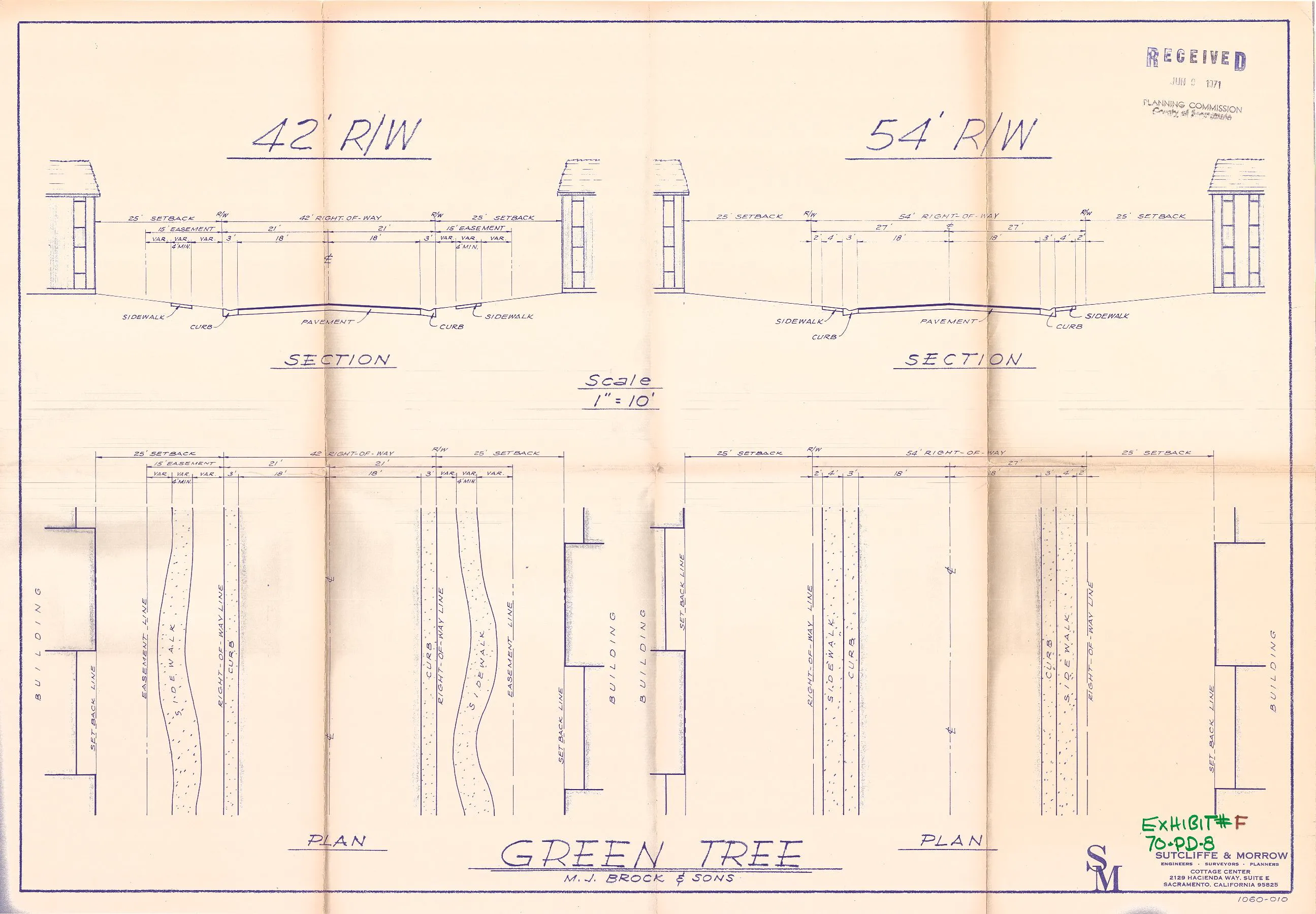
“F” - Right of way sections for 42 feet and 54 feet rights of way.
SECTION 3.
Section titled “SECTION 3.”The word “unstable” in subdivision (E) seems to be a typographical error present in the original adopted ordinance. It is likely the intent was the word “usable.”
During the public hearings on this ordinance the Planning Commission and the Board of Supervisors determined that:
- The proposed development will carry out the intent of the General Plan.
- The proposed development is of sufficient size and is designed so as to provide a desirable environment within its own boundaries.
- The proposed development is compatible with existing and proposed land uses in the surrounding area.
- Exceptions to the Standard requirements of the Basic Zoning Ordinance are justified by the design of the development.
- The arrangement of dwellings is justified by larger and more unstable open spaces.
- There is adequate assurance that all public improvements will be installed at the scheduled times as required by the Public Works Department.
- There is adequate assurance that the development schedule will be met.
- The existing and proposed utility services are adequate for the uses and population densities proposed.
SECTION 4.
Section titled “SECTION 4.”The schedule for development of the property described in Exhibit “A” and as shown on Exhibit “B” shall be as follows:
- Construction of Phase No. 1 as shown on Exhibit "C" shall commence not later than twelve (12) months of the final approval of the Board of Supervisors of this ordinance.
- The schedule for construction of subsequent units shall be approved by the Planning Department. Construction for subsequent units shall not commence until the construction schedule for the subsequent units has been approved.
- Construction of the common area of each phase shall be contemporaneous with the construction of the dwelling units and other improvements in each phase. It is the intent of the Board of Supervisors that the residents of each phase shall have available to them the common area facilities in phase as soon as the dwelling units are occupied.
- Construction as used herein shall include landscaping.
SECTION 5.
Section titled “SECTION 5.”Except as provided in Section 6, the location, arrangement, and setback of dwelling units, recreational facilities, private streets, parking areas, carports, and walkways shall be set forth in Exhibit “B”.
SECTION 6.
Section titled “SECTION 6.”For dwelling units which have the narrow end of the unit adjacent to a public street, the minimum setback for said dwelling unit shall be twenty-five (25) feet. The minimum setback for all other buildings shall be twenty (20) feet.
SECTION 7.
Section titled “SECTION 7.”Travel trailers, campers, boats, boat trailers, utility trailers and similar vehicles may be stored on the property described in Exhibit “A” provided such vehicles shall of of a size that will fit within a garage or carport.
SECTION 8.
Section titled “SECTION 8.”It is the intent of the Board of Supervisors in adopting this ordinance to permit flexibility in the arrangement of the building types within the building groups described in Exhibit “B”. For the purpose of this ordinance and to carry out this intent the developer may construct any of the building types described in any of the exhibits herein provided that (a) the number of building groups remains the same as shown on Exhibit “B”, (b) the number of buildings within a building group does not exceed the number of buildings within the building groups as shown on Exhibit “B”.
SECTION 9.
Section titled “SECTION 9.”Parking stalls designated on Exhibit “B” shall comply with the parking stall requirements as specified in Section 19 of the Basic Zoning Ordinance of Sacramento County, Ordinance No. 534, as amended.
SECTION 10.
Section titled “SECTION 10.”The Articles of Incorporation, By-laws of the Homeowners’ Association and Declaration of Covenants, Conditions and Restrictions shall be approved by the County Counsel prior to the issuance of any building permits for the property described in Exhibit “A”.
SECTION 11.
Section titled “SECTION 11.”Each dwelling unit shall be used as a residence for a single family and for no other purpose. No business of any kind shall be conducted in the residences with the exception of the business of the developer in completing the construction of the residences and disposing of same by sale, lease or otherwise. The developer shall also be permitted the use of model dwellings, which if altered for display purposes, shall be restored as dwelling houses upon the completion of the sales program.
SECTION 12.
Section titled “SECTION 12.”All signs used by the developer in advertising the sales program or by individual dwelling unit owners for the advertisement of the property or dwelling unit for sale shall comply with the Basic Zoning Ordinance of Sacramento County, Ordinance No. 534, as amended.
SECTION 13.
Section titled “SECTION 13.”Violation of the provisions of this ordinance, or exhibits made part of this ordinance, shall be deemed a violation of the Basic Zoning Ordinance of Sacramento County, Ordinance No. 534, as amended.
SECTION 14.
Section titled “SECTION 14.”Minor deviations in location of dwelling units, carports, and outdoor parking shall be permitted if approved by the Zoning Administrator. The Board of Supervisors hereby authorizes the Zoning Administrator to make such minor changes and in so authorizing has determined that such minor changes do not constitute an amendment to the Basic Zoning Ordinance, as amended. The developer shall not remove any of the existing trees identified on Exhibit “B” without approval of the Zoning Administrator.
EXHIBIT “A” - DESCRIPTION
Section titled “EXHIBIT “A” - DESCRIPTION”PARCEL NO. 1:
Section titled “PARCEL NO. 1:”All that portion of Lot 55, as shown and so designated on the “Plat of Haggin Park”, recorded May 24, 1913 in Book 14 of Maps, Map No. 26, records of said County, described as follows:
Beginning at a point on the west line of said Lot 55, said point being on the centerline of Hackberry Lane, from which the northwest corner of said Lot 55 bears North 01º 46’ 30“ West 172.66 feet; thence from said point of beginning South 89º 38’ 00“ East 402.99 feet; thence North 00º 37’ 00“ West 181.97 feet to a point on the North line of said Lot 55; thence along the North line of said Lot 55, North 89º 02’ 30“ East 265.07 feet; thence parallel to the East line of said Lot 55, South 00º 46’ 30“ East 659.94 feet to a point on the South line of said Lot 55, thence South 89º 02’ 30“ West 660.71 feet to the southwest corner of said Lot 55, thence along the West line of said Lot 55 and the center line of said Hackberry Lane North 01º 46’ 30“ West 487.34 feet to the point of beginning.
PARCEL NO. 2:
Section titled “PARCEL NO. 2:”Lots 56 and 57 as shown on the “Plat of Haggin Park”, recorded May 24, 1913 in Book 14 of Maps, Map No. 26, records of said County.
EXCEPTING THEREFROM that portion of said Lot 56 described as follows:
Beginning at a point on the Westerly boundary of said Lot 56, said point being on the center line of Hackberry Lane, formerly known as Redwood Avenue, from which point of beginning the Northwest corner of said Lot 56 bears North 19º 46’ East 258.74 feet; thence from said point of beginning parallel to the North line of said Lot 56, North 89º 02’ 30“ East 509.00 feet; thence South 00º 46’ 30“ East 275.00 feet; thence South 89º 02’ 30“ West 458.33 feet to a point on the Westerly boundary of said Lot 56; thence along said Westerly boundary the following two courses, and distances; North 18º 47’ 30“ West 230.81 feet and thence North 19º 46’ East 59.09 feet to the point of beginning.
EXHIBIT “B” - Site Plan.
Section titled “EXHIBIT “B” - Site Plan.”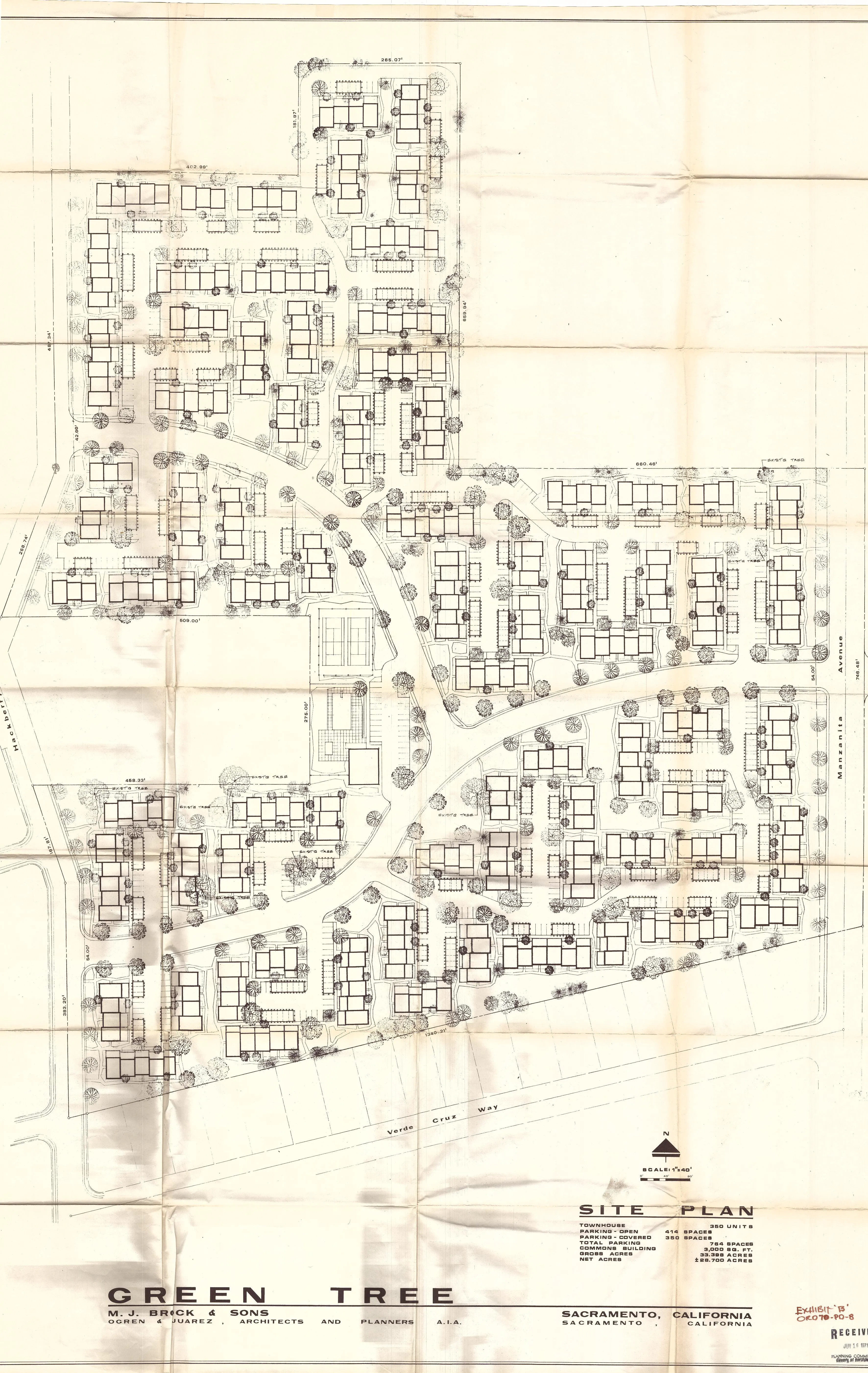
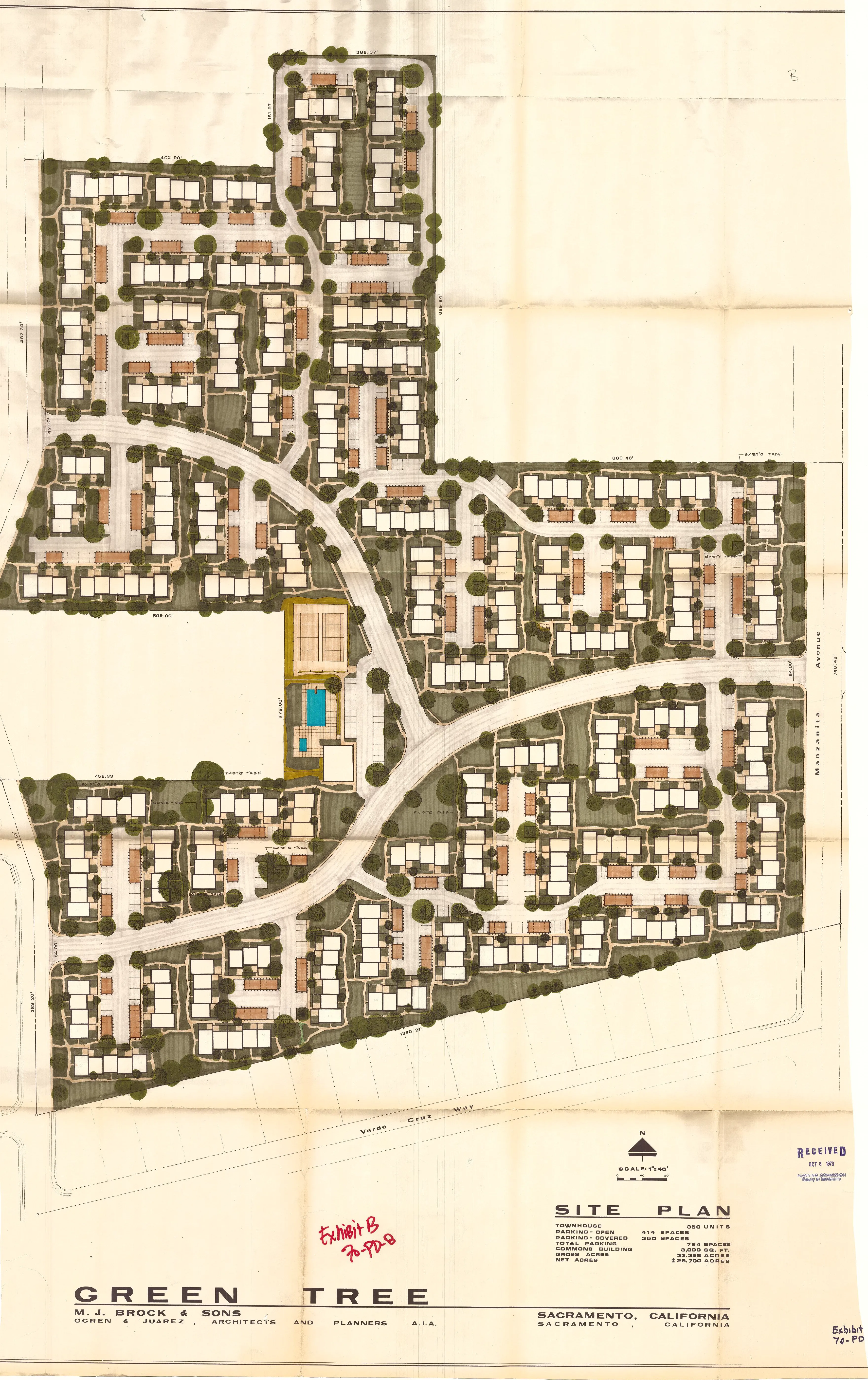
EXHIBIT “C” - Site Plan for Phase No. 1 of the total project.
Section titled “EXHIBIT “C” - Site Plan for Phase No. 1 of the total project.”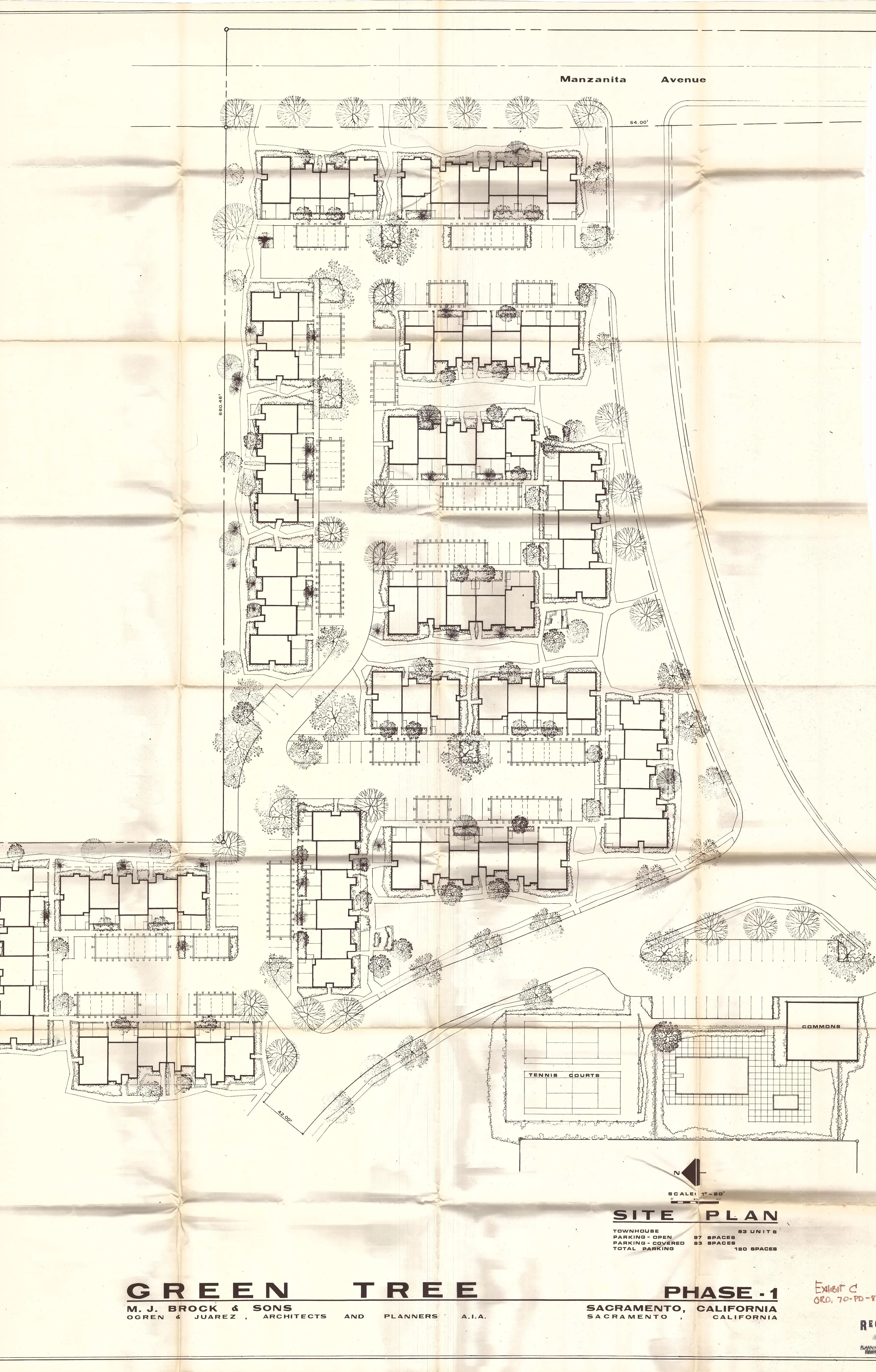
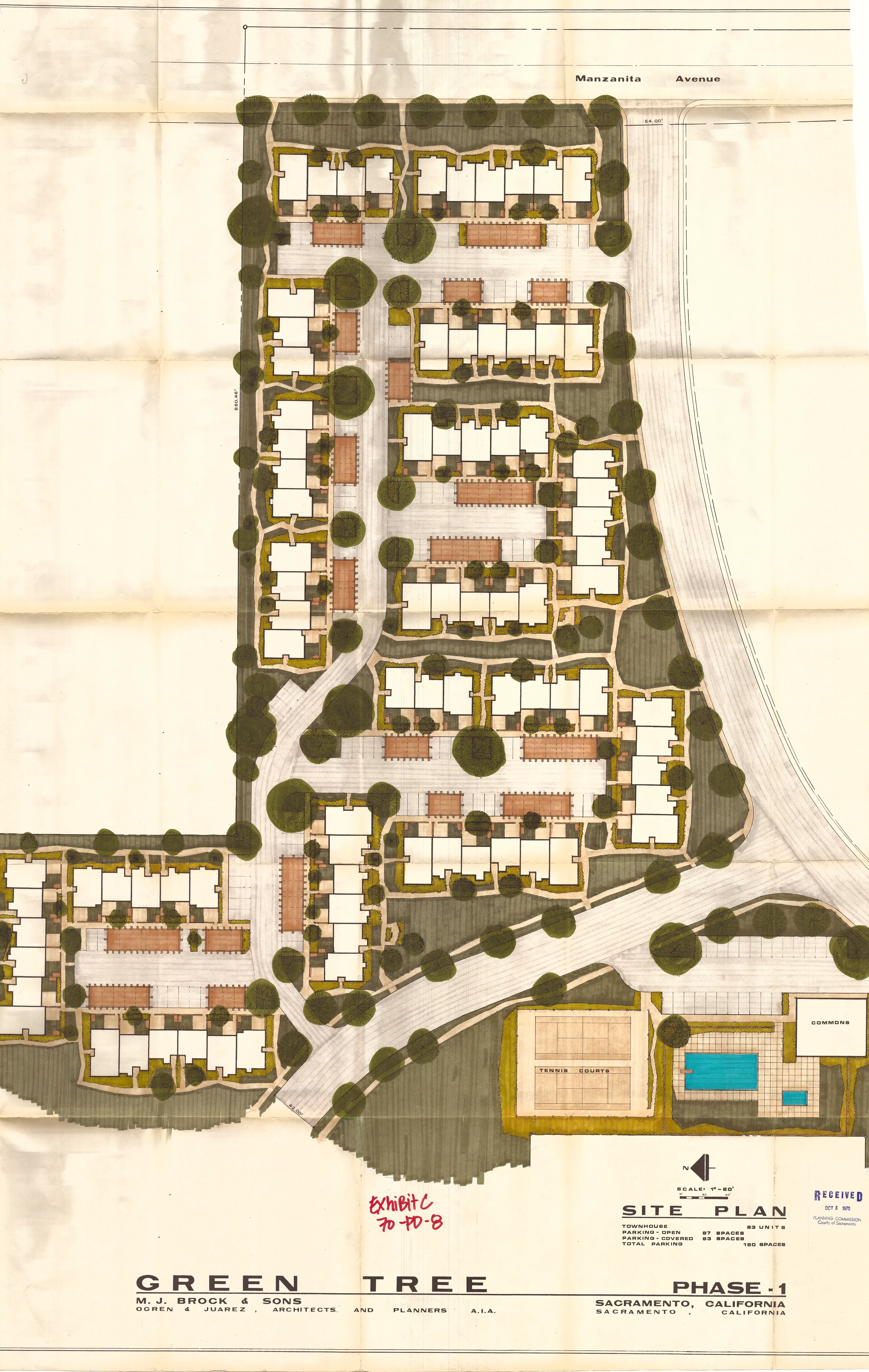
EXHIBIT “D” - Elevation drawings and floor plans for typical dwelling units.
Section titled “EXHIBIT “D” - Elevation drawings and floor plans for typical dwelling units.”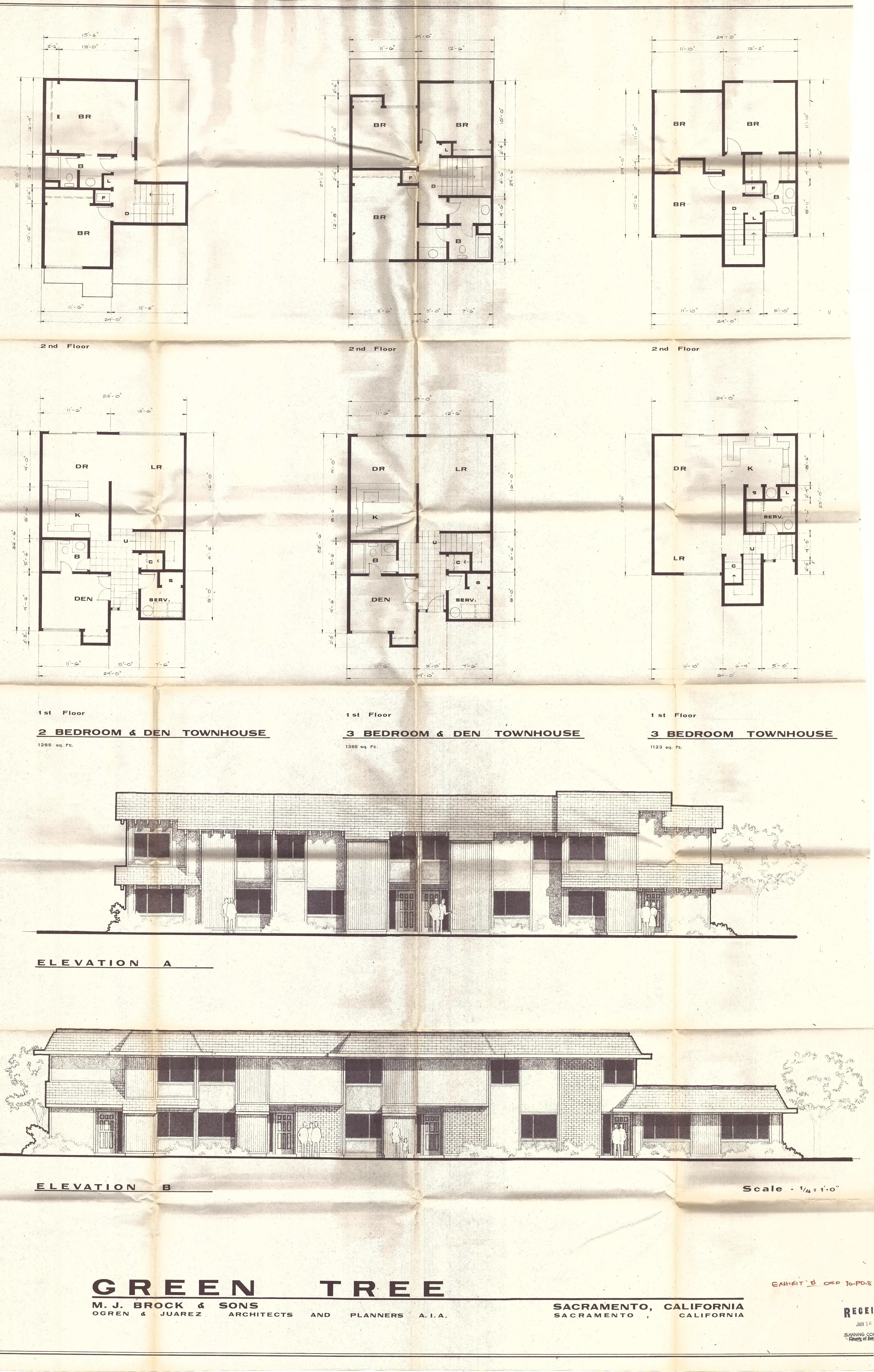
EXHIBIT “E” - Elevation drawings and floor plans for typical dwelling units.
Section titled “EXHIBIT “E” - Elevation drawings and floor plans for typical dwelling units.”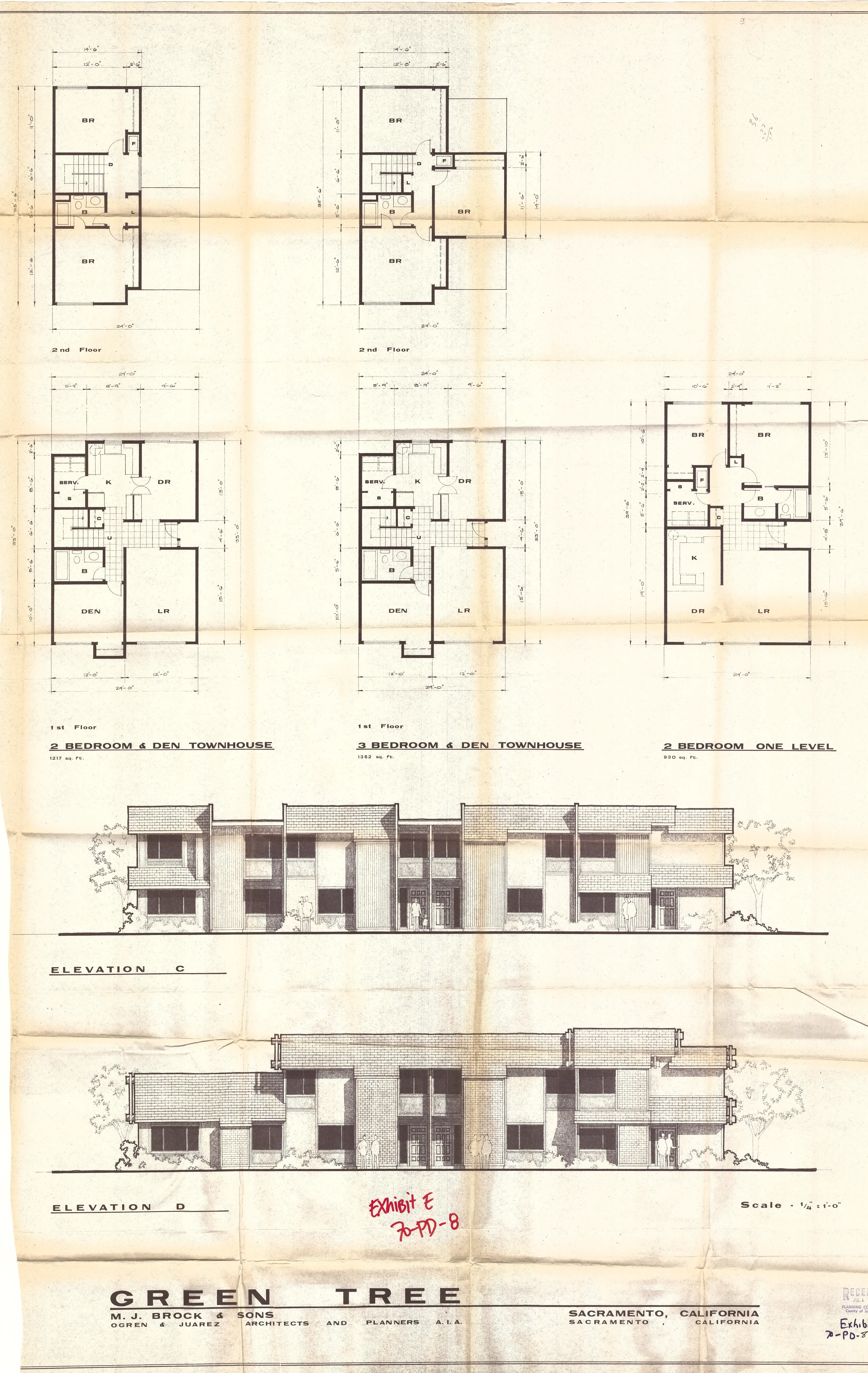
EXHIBIT “F” - Right of way sections for 42 feet and 54 feet rights of way.
Section titled “EXHIBIT “F” - Right of way sections for 42 feet and 54 feet rights of way.”