Metro Air Park SPA
Sacramento County Zoning Code
Metro Air Park Special Planning Area Ordinance
Section titled “Sacramento County Zoning Code Metro Air Park Special Planning Area Ordinance”Adopted May 12, 1993 as the Metropolitan Airport/Vicinity Special Planning Area Ordinance
Amended February 25, 1998 & August 5, 1998 & August 5, 2008 & July 8, 2016 & December 1, 2016 & October 16, 2018 & November 19, 2019 & August 23, 2022
83-SPA-3
Adopted by 1989-GPB-ZOB-0781
Amended by 1996-ZOB-SDP-BLS-PAP-ABE-0447 (Metro Air Park) & 1998-ZOB-XXB-0131 & PLNP2007-00447 & PLNP2016-00125 & PLNP2016-00351 & PLNP2018-00075 & PLNP2019-00038 & PLNP2021-00114
505-30. INTENT.
Section titled “505-30. INTENT.”It is the intent of the Board of Supervisors in adopting this Special Planning Area (SPA) Ordinance to allow development of Metro Air Park as a high quality, multi-use, commercial and industrial business park.
Land uses in the Metro Air Park include airport related uses, light manufacturing, high tech research and development, professional offices, retail and recreation. This balanced mix of uses will ensure economic viability while providing an economic business environment, which is complementary to the airport.
Metro Air Park will have a distinctive identity reflecting its relationship to the airport, its orientation around an open space/recreation spine that will also accommodate drainage and wildlife needs and its incorporation of landscape and site design considerations as set forth in the Metro Air Park Landscape and Design Guidelines (Exhibit 100-116).
505-31. EXHIBITS.
Section titled “505-31. EXHIBITS.”Exhibits 100-111, 100-112, 100-114, 100-115, and 100-116 described in this section and adopted by ordinance, are intended to regulate property described by this ordinance. Exhibit 100-116 is on file in the office of the Clerk of the Board of Supervisors, and a part of this ordinance as if fully set forth herein. Exhibits 100-111, 100-112, 100-114 and 100-115 are attached.
- Exhibit 100-111 - Land Use Distribution by Zoning District
- Exhibit 100-112 - Metro Air Park Special Planning Area Boundaries
- Exhibit 100-113 - Deleted
- Exhibit 100-114 - Metro Air Park, Land Use Districts
- Exhibit 100-115 - Metro Air Park, Circulation Plan, as amended 9-23-2022
- Exhibit 100-116 - Metro Air Park, Landscape and Design Guidelines, as amended 9-23-2022
505-32. DEFINITIONS.
Section titled “505-32. DEFINITIONS.”For the purposes of this ordinance, the following definitions are applicable:
-
CLUP Compliance. Any use proposed within the Metro SPA which is not consistent with the terms of the Metropolitan Airport Comprehensive Land Use Plan (Metro CLUP) shall only be permitted upon approval by the Board of Supervisors and after making the necessary findings as required by the Sacramento County General Plan and the Metro CLUP.
-
Floor Area Ratio (FAR). Determined by dividing the gross floor area of all buildings on a lot by the gross area of that lot. Intended primarily to help achieve a lower traffic generation level for the overall business park (i.e., the property described by this ordinance).
-
High Tech/R & D Uses. A building or group of buildings in which are located facilities for scientific research, investigation, testing, for experimentation with limited manufacturing and assembly of products pertaining to the following fields, including similar and like fields:
- Medical, dental or optical
- Medical electronics and equipment
- Computers, parts and chips, integrated circuits
- Automotive design
- Aircraft design
- Physics
- Chemistry
- Biology
-
Lot Coverage. The maximum allowable percentage of a parcel of land covered by a building.
-
Net Acreage. Net Acreage is the total developable area exclusive of major roads, collector and local access streets
505-33. DESIGN REVIEW.
Section titled “505-33. DESIGN REVIEW.”A Design Review shall be conducted to ensure an orderly development pattern, facilitate good design practices and maintain a harmonious character to the design and appearance of property and structures at Metro Air Park. The required Design Review will be bundled with any applicable planning entitlement, as provided for in the Sacramento County Zoning Code.
-
FAA Review. Prior to with Design Review approval, the architect or applicant shall complete and electronically submit the Federal Aviation Administration (FAA) Form 7460-1 to the FAA’s Obstruction Evaluation Group (OEG). Upon FAA review and approval, applicant shall submit a copy of the determination letter stating that the FAA does not object to the proposed plans to the Sacramento County Planning and Environmental Review Division.
-
Applicability. Prior to the issuance of any building permit, all public and private construction, development, redevelopment or improvement projects within the area shown in Exhibit 100-114 shall undergo a Design Review as stated in Section 6.3.2. of the Sacramento County Zoning Code, except:
- Improvements to existing buildings that do not alter the outward appearance of the building exterior;
- Improvements of less than $10,000, excluding signs;
- Public works, utility and maintenance projects, including:
- Roadway and landscape maintenance, repaving, rehabilitation of irrigation, tree trimming, mowing, weed abatement, sidewalk repair, parking lot striping, placement of parking and roadway placards/signs;
- Existing utility improvement and maintenance, undergrounding of utilities, maintenance of utility poles, sewer or water lines, water wells & related facilities, drainage facilities;
- Other public works, utility or maintenance projects as determined by the Director of Planning and Environmental Review.
-
Regulating Documents. The Design Review shall be based on guidelines as described in Exhibit 100-116: Metro Air Park Landscape and Design Guidelines. For uses not addressed in Exhibit 100-116, refer to the Sacramento County Countywide Design Guidelines as the appropriate underlying document.
-
Metro Air Park Property Owners Association (MAPPOA). Concurrent with application submittal to County staff for any Planning application process with Sacramento County, applicants, or their representatives, must submit their proposal to MAPPOA and obtain an written acknowledgement of the project site plan, architecture, and landscape architecture. Written acknowledgement from MAPPOA must be received by the Planning and Environmental Review Division prior to issuance of a Design Review determination.
-
Pre-application Meeting. Applicants, or their representatives, are encouraged to meet with the County staff and review their proposal well in advance of their plans to submit a request for a building permit. A pre-application meeting is not a requirement of the Design Review process; however, receiving “early review and comment” may accelerate the timeframe associated with the formal review of an applicant’s proposal.
-
Application Submittal & Fees. Applicants should refer to the Design Review Program application checklist for submittal requirements and shall submit the package together with the appropriate fees, to the Sacramento County Planning and Environmental Review Division. Within 30 days after receiving the application for Design Review, the Design Review Administrator (DRA), or designee, shall review the application for completeness. If determined not to be complete, the DRA, or designee may request additional information. The application for Design Review will not be deemed complete until all additional information that is required by the DRA has been received. Development of individual sites will require a Design Review determination. Development may not take place on any property within the Metro Air Park SPA until a Design Review determination is obtained from the DRA or as otherwise provided herein. Design Review requests submitted for DRA determination shall demonstrate, by appropriate maps and written explanation, the project’s consistency with Exhibit 100-116 Metro Air Park Landscape and Design Guidelines.
-
Authority & Appeals. The following provisions define the appropriate authority for conducting design review:
- The Design Review Administrator (DRA) is the appropriate authority to conduct Design Review as set forth in the Sacramento County Zoning Code 6.3.2.E.1. The DRA, may make a determination of consistency or inconsistency with the Metro Air Park Landscape and Design Guidelines (Exhibit 100-116).
- Decisions of the DRA may be appealed to the Board of Zoning Appeals pursuant to the provisions of Sacramento County Zoning Code Section 6.1.3.
- Submission Requirements and Review Procedures. Development of individual sites will require a determination of consistency with the Metro Air Park Landscape and Design Guidelines (Exhibit 100-116). Development may not take place on any property within the Metro Air Park SPA until the Design Review determination is obtained from the DRA, or as otherwise provided herein. Design Review requests shall demonstrate, by appropriate maps and written explanation, the project's consistency with Exhibit 100-116 Metro Air Park Landscape and Design Guidelines.
-
Design Review Required Findings. In making the Design Review determination, the DRA must find that the request complies with the intent and follows criteria of this ordinance, and that the design is consistent with the Development Standards of this ordinance.
505-34. SPECIAL DEVELOPMENT PERMITS.
Section titled “505-34. SPECIAL DEVELOPMENT PERMITS.”A proposed project within the Metro Air Park Special Planning Area may request deviations from the Floor Area Ratios (FAR) of Section 505-37 or the Development Standards of Section 505-38 through a Special Development Permit.
-
Purpose. The purpose of a Special Development Permit is to encourage a creative and more efficient approach to the use of land; to maximize the choice in the type of environment available; and to provide a means of greater creativity and flexibility in design than is provided under the strict application of the zoning district development standards while at the same time providing adequate protection of the environment and of the health, safety and comfort of the users of the development.
-
Decision Authority & Appeals.
- The Planning Commission may issue a Special Development Permit to allow deviations from the required Floor Area Ratios or any development standard listed in this document.
- Decisions of the Planning Commission may be appealed to the Board of Supervisors pursuant to the provisions of Sacramento County Zoning Code Section 6.1.3.
-
Effect of Permit. Upon the issuance of the Special Development Permit, the property may be developed either pursuant to the development standards set forth in this document or in the alternative, pursuant to the development standards set forth in the Special Development Permit and the requirements set forth in this document; provided, however, that upon the issuance of any building permit for the construction of streets, utilities, and other facilities pursuant to the development standards set forth in the Special Development Permit, the Special Development Permit shall regulate the property, and shall remain in full force and effect until revoked.
-
General Findings for All Special Development Permits. The hearing body shall not issue the Special Development Permit unless the following general findings can be made:
- That the proposed development will carry out the intent of the SPA;
- That the proposed development is of sufficient size and is designed so as to provide a desirable environment within its own boundaries;
- That the development is compatible with existing and proposed land uses in the surrounding area;
- The proposed development is justified by the project design or by the substantial energy savings proposed;
- That there is adequate assurance that all necessary infrastructure will be installed at the scheduled times;
- That the existing or proposed utility services are adequate for the uses proposed; and
- That the proposed development will not be materially detrimental to the environment or to the health, safety, or general welfare of the people utilizing the development and residents of the County.
-
Issuance of Permit. The Special Development Permit, when approved by the hearing body, shall incorporate the approved plans and detailed regulations setting forth the requirements for development on the site. The permit may, in addition, specify the authority to review and approve details of the development plan, provided that standards for such review are set forth in the Permit. The hearing body may also designate conditions of approval for a Special Development Permit to satisfy the requirements of this document. Such conditions may include, but are not limited to, right-of-way dedication and regulations on building height, landscaping and fencing, and shall be related to the nature of the Special Development Permit.
505-35. PERMITTED AND CONDITIONALLY PERMITTED USES.
Section titled “505-35. PERMITTED AND CONDITIONALLY PERMITTED USES.”Metro Air Park is composed of districts as indicated by Exhibit 100-114 and described below. Uses permitted, conditionally permitted, and prohibited in each district are set forth in Table 1. Additional permitted or conditionally permitted uses are listed in Table 3.1 in Section 3.2.5 of the Sacramento County Zoning Code under the corresponding underlying zoning designation for each district. Temporary and Accessory uses may be authorized as provided for in Sections 3.1.2.C and D of the Sacramento County Zoning Code.
1. District 1: Light Manufacturing and Distribution District
Section titled “1. District 1: Light Manufacturing and Distribution District”Purpose: This district is intended to provide for permitted light industrial uses which include fabrication, manufacturing, assembly, distribution, processing or storage of materials that, for the most part, are already in processed form and which do not in their maintenance, assembly, manufacture, or plant operation create smoke, gas, odor, dust, sound, or other objectionable influences which might be obnoxious to persons conducting business in this or any other zone. The corresponding underlying zone as referenced in the Sacramento County Zoning Code is M-1 (Light Industrial).
2. District 2: Airport Manufacturing and Distribution District
Section titled “2. District 2: Airport Manufacturing and Distribution District”Purpose: This district is intended to provide for most of the uses permitted in Districts 1, plus the permitted light industrial uses which are directly related to airport functions. This includes both those uses which do and do not require physical adjacency to the airport. The corresponding underlying zone as referenced in the Sacramento County Zoning Code is M-1 (Light Industrial).
3. District 3A: Office - Retail/High Tech/R & D District Core
Section titled “3. District 3A: Office - Retail/High Tech/R & D District Core”Purpose: This district is intended to provide for well-designed and controlled high-tech office space and limited commercial services supporting the surrounding uses. The corresponding underlying zone as referenced in the Sacramento County Zoning Code is MP (Industrial/Office Park).
4. District 3B: Office - High Tech/R&D District Periphery
Section titled “4. District 3B: Office - High Tech/R&D District Periphery”Purpose: This district is intended to support the High Tech/R & D District Core by providing the space needed for larger high-tech/research and development uses. Limited manufacturing and assembly of products will be permitted. A mix of industrial, manufacturing, research and office uses is expected to develop. The corresponding underlying zone as referenced in the Sacramento County Zoning Code is M-1 (Light Industrial).
5. District 4: Office/Hotel/Retail Services District - East/West:
Section titled “5. District 4: Office/Hotel/Retail Services District - East/West:”Purpose: This district is intended to provide office space as well as commercial services which are in support of the airport and the Metro Air Park users. The corresponding underlying zone as referenced in the Sacramento County Zoning Code is GC (General Commercial).
6. District 5A: Office/Hotel/Retail Services District - Core
Section titled “6. District 5A: Office/Hotel/Retail Services District - Core”Purpose: This district is intended to serve as the focus of business activity in Metro Air Park by providing for small office uses and retail uses for visitors and employees. It is envisioned as a pedestrian oriented, campus-like environment with direct connections to the surrounding districts, open space system and future light rail transit system. The corresponding underlying zone as referenced in the Sacramento County Zoning Code is GC (General Commercial).
7. District 5B: Office/Hotel/Professional Services District - North
Section titled “7. District 5B: Office/Hotel/Professional Services District - North”Purpose: This district is intended to provide for a variety of general and professional office uses and supplemental services. The corresponding underlying zone as referenced in the Sacramento County Zoning Code is GC (General Commercial).
8. District 5C: Office/Hotel/Retail/Services District - Central
Section titled “8. District 5C: Office/Hotel/Retail/Services District - Central”Purpose: This district is intended to provide office space as well as commercial services which are in support of the airport and the Metro Air Park users. With its visually prominent location at the main gateway off Interstate 5, strong environmental and architectural controls are necessary. The corresponding underlying zone as referenced in the Sacramento County Zoning Code is GC (General Commercial).
9. District 6: Recreation and Open Space District
Section titled “9. District 6: Recreation and Open Space District”Purpose: This district is intended to meet on-site drainage requirements while providing for aesthetic, recreation and land use buffering purposes. The corresponding underlying zone as referenced in the Sacramento County Zoning Code is O (Recreational).
505-36. USE TABLE
Section titled “505-36. USE TABLE”Purpose: The purpose of the Use Table is to designate the permitted, conditionally permitted, and prohibited uses within the buildable area of the districts described above.
Permitted Uses: A “P” in the column opposite a use listed indicates that it is permitted in the district represented by the district number at the top of the column.
Conditionally Permitted Uses: A number in the column opposite a use indicates the use is permitted up to a maximum acreage within the SPA, or permitted with the issuance of a Use Permit and Design Review in the district represented by the district number at the top of the column. The number within the column references the corresponding footnote below the Use Table.
Prohibited Uses: A blank space in the column opposite a use indicates the use is prohibited in the district represented by the district number at the top of the column.
Uses Not Listed: If a use is not listed in the Use Table, refer to the District’s corresponding underlying zone in the Sacramento County Zoning Code to determine whether that use is allowed.
Similar and Like Uses: If a use is not listed in the Use Table or Sacramento County Zoning Code and is similar or like to other permitted uses; the appropriate authority may grant a use permit for such use as provided for in Section 3.2.4.B of the Sacramento County Zoning Code.
TABLE 1: USE TABLE
Section titled “TABLE 1: USE TABLE”| Use Code | Use Classification | Dist 1 | Dist 2 | Dist 3A | Dist 3B | Dist 4 | Dist 5A | Dist 5B | Dist 5C | Dist 6 |
|---|---|---|---|---|---|---|---|---|---|---|
| A. | AIRPORT AND RELATED USES | |||||||||
| A.1 | Aircraft sales, lease, rent, storage, repair charter service | P | ||||||||
| A.2 | Airport-related manufacturing, repair, assembly, sales distribution | P | ||||||||
| A.3 | Hangars, shops and warehousing of merchandise and equipment for aircraft and aircraft ground support equipment | P | ||||||||
| A.4 | Aviation schools | P | P | |||||||
| A.5 | Package delivery/baggage transfer service | P | P | |||||||
| A.6 | Flight kitchens/caterers | P | ||||||||
| A.7 | Offices, when incidental to a permitted use | P | P | |||||||
| A.8 | Food services not occupying more than 15% of the total floor area | P | P | |||||||
| B. | INDUSTRIAL AND MANUFACTURING USES | |||||||||
| B.1 | Machinery shop uses | P | P | P | [5] | [5] | [5] | |||
| B.2 | Sign manufacturing | P | P | P | [5] | |||||
| B.3 | Manufacturing, compounding, processing, assembly, and fabrication | P | P | P | [5] | [5] | [5] | |||
| B.4 | Printing shops, lithography, publish | P | P | P | P | P | P | P | P | |
| B.5 | Assembly of small electrical and electronic equipment | P | P | P | P | [5] | [5] | [5] | ||
| B.6 | Warehousing and wholesale distribution | P | P | P | [5] | [5] | [5] | |||
| B.7 | Moving and storage | P | P | P | P | [5] | [5] | [5] | ||
| B.8 | Mini Storage | P | P | [5] | [5] | [5] | ||||
| B.9 | Offices, when incidental to a permitted use | P | P | P | P | |||||
| B.10 | Food services not occupying more than 15% of the total floor area | P | P | P | P | P | P | P | P | |
| B.11 | Concrete Batch Plant | |||||||||
| B.12 | Animal Slaughter, Tannery, and Rendering | |||||||||
| B.13 | Hazardous Waste Storage/Disposal Facility | |||||||||
| B.14 | Junk Tire Handling | |||||||||
| B.15 | Junkyard, Wrecking Yard, Scrap Yard | |||||||||
| B.16 | Wastewater Disposal | |||||||||
| B.17 | Minor Recycling Facilities | P | P | |||||||
| B.18 | Accessory Use: Storage of Flammable, Explosive or Highly Corrosive Materials | P | P | P | P | |||||
| C. | VEHICLE RELATED USES | |||||||||
| C.1 | Auto rental, wholesale, or lease agency, including limousine service | P | P | P | P | P | P | P | ||
| C.2 | Automobile vehicle storage and service/preparation including wash and preparation facilities | [1] | [1] | [1] | [1] | [1] | ||||
| C.3 | Recreational vehicle and boat sales and rentals | [1] | [1] | [1] | [1] | [1] | ||||
| C.4 | Auto/Truck fueling station with or without convenience store and liquor sales | [1], [6] | [1], [6] | [1], [6] | [1], [6] | [1], [6] | [1], [6] | [1], [6] | [1], [6] | |
| C.5 | Automobile/Truck wash | [1] | [1] | [1] | [1] | [1] | [1] | [1] | [1] | |
| C.6 | Auto commercial parking lot/garage | P | P | P | P | P | P | P | ||
| C.7 | Storage of Towed or Damaged Vehicles and Boats | |||||||||
| D. | RETAIL SALES AND SERVICE USES | |||||||||
| D.1 | Personal services | P | P | P | P | P | P | P | P | |
| D.2 | Restaurants, Eating/Drinking/Lodging: | |||||||||
| D.2.a | Bar/tavern | [2] | [2] | [2] | [2] | |||||
| D.2.b | Brew Pub | [2] | [2] | [2] | [2] | |||||
| D.2.c | Catering service | P | P | P | P | P | P | |||
| D.2.d | Restaurant, Carry-out/Drive-through/Sit-down | [2] | [2] | [2] | [2] | [2] | ||||
| D.2.e | Hotels/Motels | [3] | [3] | [3] | [3] | [3] | ||||
| D.2.f | Hotel with Convention/Conference Facility | [3] | [3] | [3] | [3] | [3] | ||||
| D.2.g | Event Center/Convention Facilities | [2] | [2] | [2] | ||||||
| D.2.h | Restaurant/Coffee Shop/Cafeteria | [2] | [2] | [2] | [2] | [2] | [2] | |||
| D.2.i | Retail use less than 1,500 S.F., auxiliary to hotel use | P | P | P | P | P | ||||
| D.3 | Entertainment/Recreation Services: | |||||||||
| D.3.a | Art gallery/studio | P | P | P | P | |||||
| D.3.b | Public parks and ancillary uses | P | P | P | P | P | P | P | ||
| D.3.c | Museum | P | P | P | P | P | P | |||
| D.3.d | Gyms/Fitness studio | [2] | [2] | [2] | [2] | [2] | [2] | [2] | [2] | |
| D.3.e | Public recreation golf course and ancillary uses including clubhouse, parking | P | ||||||||
| D.3.f | Live/Motion Picture Theater and Performing Arts Center | [2] | [2] | [2] | [2] | |||||
| D.4 | Food, Drug, Liquor Sales: | |||||||||
| D.4.a | Bakery, pastry shop, candy shop | [2] | [2] | [2] | [2] | |||||
| D.4.b | Liquor store/off-sale of alcoholic beverages | [2] | [2] | [2] | [2] | |||||
| D.4.c | Prescription/non-prescription pharmacy | [2] | [2] | [2] | [2] | |||||
| D.4.d | Neighborhood convenience store, food markets | [2] | [2] | [2] | [2] | |||||
| D.5 | General Retail Merchandise Sales | [2] | [2] | [2] | [2] | [2] | ||||
| D.6 | Adult Business Uses | |||||||||
| D.7 | Public Auction, Flea Market | |||||||||
| E. | OFFICE AND PROFESSIONAL USES | |||||||||
| E.1 | General Office | [4] | [4] | [4] | [4] | |||||
| E.2 | Financial offices/Banks | [4] | [4] | [4] | [4] | |||||
| E.3 | Corporate Office | [4] | [4] | [4] | [4] | |||||
| E.4 | Medical or dental office | [4] | [4] | [4] | [4] | |||||
| E.5 | Real estate office | [4] | [4] | [4] | [4] | |||||
| E.6 | Building trades contractors office | [4] | [4] | [4] | [4] | [4] | [4] | |||
| E.7 | Federal and State buildings, facilities, and grounds | P | P | P | P | P | P | P | P | |
| E.8 | Aviation-related offices | [4] | [4] | [4] | [4] | [4] | [4] | [4] | ||
| E.9 | Food services not occupying more than 15% of the total floor area | P | P | P | P | P | P | P | P | |
| F. | HIGH TECH RESEARCH & DEVELOPMENT USES | |||||||||
| F.1 | Research and development facilities | P | P | |||||||
| F.2 | Laboratory, medical, dental, research, or optical | P | P | |||||||
| F.3 | Aircraft related research and development | P | P | P | P | |||||
| F.4 | Offices, when incidental to a permitted use | P | P | P | P | |||||
| F.5 | Food services as one tenant in a building and not occupying more than 15% of the total floor area | P | P | P | P | P | P | P | P | |
| G. | PARKING FACILITIES | |||||||||
| G.1 | Ground-level and/or underground parking facilities. | P | P | P | P | P | P | P | P | |
| H. | RESIDENTIAL USES | |||||||||
| H.1 | All Residential Uses | |||||||||
| H.2 | Recreational Vehicle Park, Travel Trailer Park | |||||||||
| I. | PUBLIC, CIVIC, AND INSTITUTIONAL USES | |||||||||
| I.1 | Cemetery |
Table Footnotes
Section titled “Table Footnotes”-
Permitted use in this district, however, a maximum of 40 acres of these Vehicle-Related Uses are allowed in the Metro Air Park SPA subject to the approval of a design review as required by this ordinance.
-
Permitted use in this district, however, a maximum of 65 acres of these Retail Sales and Service Uses are allowed in the Metro Air Park SPA subject to the approval of a design review as required by this ordinance. An event center or reception hall with capacity exceeding 300 persons (per Fire Department occupancy load calculations) shall be subject to a Conditional Use Permit by the Zoning Administrator. Event centers or reception halls that are accessory to hotels or motels are exempt from the Use Permit requirement.
-
Permitted use in this district; however, a maximum of 40 acres of hotels and motels are allowed in the Metro Air Park SPA subject to the approval of a design review as required by this ordinance.
-
Permitted use in this district, however, a maximum of 420 acres of these office uses are allowed in the Metro Air Park SPA subject to the approval of a design review as required by this ordinance.
-
Permitted use in this district; however, a maximum of 300 net acres of these Industrial and Manufacturing Uses shall be permitted in Districts 4, 5B, and 5C.
-
Permitted with the issuance of a Conditional Use Permit from the Board of Supervisors.
505-37. MAXIMUM FLOOR AREA RATIOS (FAR).
Section titled “505-37. MAXIMUM FLOOR AREA RATIOS (FAR).”The following maximum floor area ratios shall be maintained in the development and the division of any lot within the industrial business park for the primary purpose of realizing no more than 142,535 external daily trips from the overall project, after accounting for TSM measures. Maximum FAR for use categories in the Use Tables of this ordinance are as follows:
-
Manufacturing - .30
-
Distribution - .48
-
High Tech/R & D - .30
-
Airport Related - .30
-
Office - .48
-
Retail Commercial - .26
-
Automotive Related - .26
-
Hotels and Motels - 60 rooms per acre
505-38. DEVELOPMENT STANDARDS.
Section titled “505-38. DEVELOPMENT STANDARDS.”The following sections set forth development standards for each district within the Metro Air Park SPA. Appropriate sections of the Sacramento County Zoning Code are referenced wherever existing regulations apply; otherwise, new standards have been developed for the SPA. In all cases, these new standards exceed the existing minimum standards.
1. Minimum Lot Area.
Section titled “1. Minimum Lot Area.”The minimum lot area shall be 10,000 square feet.
2. Minimum Lot Width.
Section titled “2. Minimum Lot Width.”The minimum permitted lot width shall be 100 feet.
3. Setbacks.
Section titled “3. Setbacks.”The minimum setback from the public street right-of-way shall be 25 feet. The minimum side and rear yard setbacks from the property line shall not be less than 5 feet, and the minimum rear yard shall not be less than 5 feet. The minimum building setback from the snake wall shall be 25 feet. This setback requirement will not apply if Lone Tree Road is located along the snake wall property line.
4. Maximum Building Height:
Section titled “4. Maximum Building Height:”- Districts 1, 2: The maximum permitted building height shall be between 106 and 173 feet above mean sea level, which is the maximum allowed by Federal Aviation Regulations (Part 77). Changes to FAA regulations may reduce this maximum height standard, but any such changes shall not increase the maximum height standards to more than between 106 and 173 feet above mean sea level. Final building height shall be determined prior to the issuance of a building permit.
- Districts 3A, 3B, 4, 5A, 5B, 5C: The maximum permitted building height shall be 173 feet above mean sea level, which is the maximum allowed by Federal Aviation Regulations (Part 77). Changes to FAA regulations may reduce this maximum height standard, but any such changes shall not increase the maximum height standards to more than 173 feet above mean sea level.
5. District-Specific Development Standards:
Section titled “5. District-Specific Development Standards:”a. District 2: Airport Interface.
Section titled “a. District 2: Airport Interface.”No use within this District shall be entitled to directly access Sacramento International Airport property, runways, taxiways or airport facilities, except upon approval of such access by the Department of Airports and Board of Supervisors.
b. District 6: Recreation and Open Space District.
Section titled “b. District 6: Recreation and Open Space District.”The Recreation and Open Space District is intended to:
- Enhance the environmental quality of the developed areas and provide recreational opportunities for the psychological and physical benefit of the employees and visitors;
- Integrate a drainage "channel" from one end of the SPA to the other;
- Accommodate existing endangered, threatened and other wildlife species;
- Buffer different land use areas, and;
- Help lower the overall employee density and trip generation levels while contributing to the overall economic value of the SPA.
The Recreation and Open Space District shall contain a mix of native and ornamental plants, many of which should be suitable to a wetland-type environment. The drainage system shall be developed as a natural-appearing amenity and may be incorporated into a golf course. Open space corridors with walkways shall also be used to separate different land uses and to connect buildings. Landscaped plazas with site furnishings, shade trees, fountains and arcades shall be developed in the Commercial and High Tech/Research and Development cores and link to the larger open space system.
Guidelines for this district are set forth in the Metro Air Park Landscape and Design Guidelines, Exhibit 100-116 of this ordinance.
6. On-Street Parking.
Section titled “6. On-Street Parking.”No on-street parking shall be permitted within Metro Air Park. Parking prohibition signs shall be installed to the satisfaction of the Department of Transportation (DOT). Enforcement of the no-parking provision shall be the responsibility of the County.
7. Bus Turnouts.
Section titled “7. Bus Turnouts.”Bus turnouts shall be provided along major streets to the satisfaction of the DOT and Regional Transit.
8. Street Lighting.
Section titled “8. Street Lighting.”Street lighting shall be provided as required by Sacramento County. Street lighting shall conform to all County improvement standards, and necessary easements shall be granted to accommodate those standards.
9. Metro Air Park Entrances.
Section titled “9. Metro Air Park Entrances.”The primary entrances into the SPA shall require special landscape treatment and a unified theme including similar monument design. A planting island or different street paving material or both shall be installed at these entrances. Entrance designs must be substantially compliant with examples set forth in the Metro Air Park Landscape and Design Guidelines, Exhibit 100-116 of this ordinance.
10. Off-Street Parking Areas.
Section titled “10. Off-Street Parking Areas.”All off-street parking areas shall be in conformance with the provisions for Off-Street Parking, Section 5.9 the Sacramento County Zoning Code, unless otherwise noted below:
- Screening. Parking located adjacent to any collector street may be screened from view by buildings or landscaped berms, or a combination of berms, walls or fences and solid evergreen shrubbery in such a manner as to reduce visibility from any public street.
- Striping. All parking spaces should be clearly outlined on the surface of the parking facility with painted white lines or stone, brick, textured or smooth concrete banding.
- Parking. The Planning Commission may approve a reduction in off-street parking as part of the TSM measures intended to achieve a peak period commute rate of 1.5 persons per vehicle set forth in an adopted TSM Plan as required by this ordinance.
11. Safety.
Section titled “11. Safety.”Access arrangements and fire hydrants shall be provided to the satisfaction of the fire district prior to any combustible construction.
12. Outside Storage and Service Areas.
Section titled “12. Outside Storage and Service Areas.”- No outside storage of materials, merchandise, products, parts or equipment, other than company vehicles, shall be permitted unless screened from view from any public street, in conformance with the Metro Air Park Landscape and Design Guidelines, Exhibit 100-116 of this ordinance.
- All permitted storage structures, exterior trash structures and service areas shall be screened from view from public roadways with a wall, fence, berm, or landscaping.
- No storage areas shall be allowed within any landscape or open space easement or front and rear-yard setback areas.
13. Loading Areas.
Section titled “13. Loading Areas.”All loading activity, including turnaround and maneuvering, shall be made on the site. Loading areas shall be located and/or screened in such a manner as to reduce visibility from any public street.
14. Fencing and Walls
Section titled “14. Fencing and Walls”- All fencing and walls shall be in conformance with Metro Air Park Landscape and Design Guidelines, Exhibit 100-116 of this ordinance. If Exhibit 100-116 is silent, standards of the Sacramento County Zoning Code Section 5.2.5 for the proposed use shall apply.
- Fencing and walls adjacent to streets shall be located outside of any Public Utility Easements (PUE) or Public Utility and Public Facility Easements (PUPFE).
- Fences deviating from standards are permitted with a Special Development Permit from the Planning Commission. Fence standards may be modified by a condition of approval by the appropriate authority as part of a separate entitlement.
15. Site Lighting.
Section titled “15. Site Lighting.”Site lighting shall be in conformance with all applicable standards of the Sacramento County Code Section 5.9.4.G, Metro Air Park Landscape and Design Guidelines Exhibit 100-116 of this ordinance, and the following additional provisions:
- Building and driveway entries, pedestrian walkways, plazas and other activity points shall be illuminated.
- Site lighting shall be coordinated architecturally with buildings and other structural streetscape features and have similar materials and style.
- Pedestrian-scale light standards shall be used adjacent to buildings and within parking areas.
16. Signs.
Section titled “16. Signs.”he Master Sign Program and signage design guidelines are set forth in the Metro Air Park Landscape and Design Guidelines (Exhibit 100-116 of this ordinance). Freestanding signs consistent with the Master Sign Program are subject to Incidental Design Review as set forth in the Sacramento County Design Review Program.
A. Development Standards
Section titled “A. Development Standards”- Freeway Monument Signs. Up to two freeway monument signs will identify Metro Air Park from I-5 near the east and west property boundaries and adjacent to I-5. Freeway Monument signage is subject to the following development standards and administrative process:
- Freeway monument signage shall be substantially compliant with the Freeway Monument Sign example (overall design and development criteria) as described in the Master Sign Program in Section 11.0 of the Metro Air Park Landscape and Design Guidelines and the applicable development standards contained therein.
- The height of the signage wall shall not exceed 70 feet.
- Gateway Signs (Primary Monument Signs). Gateway signs will identify Metro Air Park at its primary entrances or at the freeway interchange. Gateway signage is subject to the following development standards and administrative process:
- Gateway signage shall be consistent with the Primary Monument Sign example (overall design and development criteria) as described in the Master Sign Program in Section 11.0 of the Metro Air Park Landscape and Design Guidelines and the applicable development standards contained therein.
- Secondary Monument Signs. Secondary Monument Signs will identify Metro Air Park at its secondary entrances.
- Secondary Monument signage shall be substantially compliant with the Secondary Monument Sign example (overall design and development criteria) as described in the Master Sign Program in Section 11.0 of the Metro Air Park Landscape and Design Guidelines and the applicable development standards contained herein.
- Tenant Monument Signs. Tenant Monuments Signs will provide street addressing and tenant identification for building at major street driveway entries.
- Tenant Monument Signs shall be substantially compliant with the Tenant Monument Sign examples (overall design and development criteria) as described in the Master Sign Program in Section 11.0 of the Metro Air Park Landscape and Design Guidelines and the applicable development standards contained therein.
- Onsite Directional Signs. On-site directional signage shall be used to provide directional wayfinding information.
- Tenant Wall Signs. Tenant Wall Signs will be attached to the building to be used to identify tenants in both single-tenant and multi-tenant buildings. Tenant Wall signage is subject to the following administrative process:
- Tenant Wall Signs that are substantially compliant with the Tenant Wall Sign applicable examples (overall design and development criteria) as described in the Master Sign Program are exempt from MAPPOA pre-application review and approval and the Sacramento County Design Review program.
- Deviations from the Master Sign Program.
- Minor Deviations. A Minor Deviation from the Master Sign Program consists of: minor color variations and color palette options, minor sign dimension modifications, logo updates and changes, and minor font changes. A Minor Deviation shall be reviewed and approved by MAPPOA and be subject to the Sacramento County Design Review Program.
- Major Deviation. Deviations not deemed to be Minor, as described above, subject to a Special Development Permit, pursuant to the process outline in Section 505-34.
B. Installation Operation and Maintenance.
Section titled “B. Installation Operation and Maintenance.”- Installation, operation and maintenance of primary and secondary monument signs shown in Figure 4 of the Metro Air Park Landscape and Design Guidelines are the responsibility of MAPPOA or their designee.
- When projects and facilities outlined in the MAP PFFP are triggered for any reason (i.e. due to absorption rates or a specific project), any signage associated with those projects or facilities, shall be constructed and installed by MAPPOA or their designee prior to the acceptance and reimbursement of the required facilities.
17. Noise Attenuation.
Section titled “17. Noise Attenuation.”Interior noise levels of structures shall be in conformance with the County Noise Ordinance.
18. Minimum Floor Elevations.
Section titled “18. Minimum Floor Elevations.”Comply with the Sacramento County Water Agency Drainage Ordinance No. 1, as amended.
505-39. LANDSCAPE STANDARDS
Section titled “505-39. LANDSCAPE STANDARDS”Landscape standards of the Sacramento County Zoning Code, Section 5.2.4, for the proposed use, as amended from time to time, shall apply to all new development, buildings, or structures that may be erected or enlarged, and/or the maintenance of existing landscaping for all districts in the SPA, unless a differing provision is listed in this Section. Landscaping shall also follow the applicable Site Development Guidelines of the Metro Air Park Landscape & Design Guidelines, Exhibit 100-116.
1. Landscaping of Setback and Frontage Areas.
Section titled “1. Landscaping of Setback and Frontage Areas.”All areas between the edge of the street right-of-way and the building or parking lot, and visible from the public street, except for driveways and screen areas, shall be landscaped. See Sacramento County Zoning Code Section 5.2.4.F for parking lot landscaping requirements.
A. Frontage Landscaping Adjacent to Parking Lots and Driveways.
Section titled “A. Frontage Landscaping Adjacent to Parking Lots and Driveways.”- A minimum twelve (12) foot wide planter excluding curbing, shall be provided between the edge of parking areas and: 1) sidewalks, where sidewalks are detached from curb and gutter, and 2) street right-of-way where sidewalks are attached. In addition, where the right-of-way is located behind a public sidewalk or curb, any area within the street right-of-way shall be developed as a planter or landscaped area. The planter shall be designed to comply with parking lot shading and street tree requirements.
- Within this planter, trees approved by the Planning Director shall be planted no further than 30 feet on center and at least four (4) feet but not further than 10 feet from the back of the sidewalk. The planter shall also include shrubs, ground covers, and other natural growth, or stormwater quality features and drainage treatments. Nothing in this Section shall preclude the installation of additional landscaping and the planting of additional trees so long as it is consistent with visibility regulations
- Bus shelters may be located within this planter if approved by the Director of the Department of Transportation, or designee, and the regional transit agency, but shall not be placed so as to reduce the number of trees which are otherwise required by this Section.
B. Frontage Landscaping Adjacent to Buildings.
Section titled “B. Frontage Landscaping Adjacent to Buildings.”Within the area between the right-of-way and buildings, trees shall be planted no further than thirty (30) feet on center and at least four (4) feet but not further than ten (10) feet from the back of the sidewalk. The planter shall also include shrubs, ground covers, and other natural growth, or stormwater quality features and drainage treatments. Nothing in this Section shall preclude the installation of additional landscaping and the planting of additional trees so long as it is consistent with visibility regulations.
C. Landscaped Parkways.
Section titled “C. Landscaped Parkways.”When required by the County’s Improvement Standards, a minimum eight (8) foot landscaped parkway shall be provided between the curb (i.e., edge of the street right-of-way) and detached sidewalk.
- Landscape parkways may include earth berms, hedges, fences, or walls in combination with trees and plantings, and may be used for stormwater purposes.
- Alternative landscaping methods and landscape parkway requirements may be considered as part of the Design Review process.
- Street Trees. Approved trees for planting in rights-of-way and public easements shall be subject to the County’s Improvement Standards. Trees not listed in the Improvement Standards, may be planted with the approval of Planning and Environmental Review for tree selections that can provide the greatest benefits (i.e., benefits to shading, health, air quality, water and energy conservation).
D. Clustering and Alternative Design.
Section titled “D. Clustering and Alternative Design.”Alternative design approaches, such as clustering of trees, may also be approved during Design Review.
E. Pedestrian Walks and Connections.
Section titled “E. Pedestrian Walks and Connections.”Required landscape areas should include pedestrian walks and well-marked paths of travel and connections, steps, and similar hard surface areas, provided that such hard surface areas do not cover more than 25 percent of the required landscape areas. A barrier free, four (4) foot wide paved walk may be provided through the required planter at street and driveway intersections to provide unencumbered access for people with disabilities from the sidewalk to the parking lot. Such walk shall be located so as to facilitate the most direct movement of persons using sidewalk curb ramps, if such are provided.
2. Landscape Screening from Public Rights-of-Way.
Section titled “2. Landscape Screening from Public Rights-of-Way.”For industrial uses visible from a public right-of-way, not otherwise screened by required landscaping, a twelve (12) foot wide landscaped area shall be provided adjacent to the right-of-way. Landscaping shall include a combination of trees and shrubs at sufficient intervals to achieve the desired screening. Trees shall be planted at least 30 feet on center. The right-of- way elevation, relative to elevations in the adjoining property, shall be a consideration in selecting landscape plants which can accomplish appropriate visual screening.
3. Parking Lot Landscaping.
Section titled “3. Parking Lot Landscaping.”- No planter shall be less than eight (8) feet wide or have an area less than 40 square feet, excluding curbing. Smaller planter sizes may be considered through the Design Review process.
- Each planter shall include an irrigation system, unless otherwise permitted in Section 5.2.4.B.9 of the Sacramento County Zoning Code.
- Not more than 25 percent of the parking landscaped area may be covered with hard surfaces such as gravel, landscaping rock, concrete, or other impervious materials. Pervious pavement and permeable pavers may be considered a substitute for impermeable hard surface areas as described in Section 5.2.4.B.5.b of the Sacramento County Zoning Code.
- All landscaping shall be within planters bound by a curb at least six (6) inches high. Curbs separating stormwater management landscaping or other landscaped area intended to filter runoff, from parking areas, shall provide curb cuts to allow stormwater run-off to pass through them.
505-40. PERFORMANCE STANDARDS.
Section titled “505-40. PERFORMANCE STANDARDS.”The following performance standards must be met for the property described by this ordinance; the time for compliance is set forth in each standard. If no time for compliance is indicated, then the subject performance standard must be met prior to issuance of any building permit.
Notwithstanding the foregoing, the golf course in District 6 and the Exception Property may be developed prior to implementation of certain performance standards, specifically Performance Standard Nos. 1, 2e, 2f, 2g and any other performance standards deemed inapplicable or deferrable by the County. Refer to the list of conditions of approval for the Metro Air Park Golf Course (Control No. 96-ZOB-SDP-PAP-ABE-0447) for applicable performance standards for the golf course. Refer to the list of conditions of approval for the Exception Property (Control No. 98-ZOB-PAP-XXB-0142) for applicable performance standards for the industrial use.
1. SMUD Facilities.
Section titled “1. SMUD Facilities.”SMUD has identified the need for three future substations to serve the Metro Air Park Special Plan Area (MAP SPA). SMUD has a substation site secured on Meister Way, west of Lone Tree Road. Substation sites shall be dedicated on future tentative maps and final maps to SMUD’s satisfaction. The substation sites will be an approximate size of 250 feet by 250 feet of net useable area (approximately 62,500-square-feet of net usable area) and shall be unencumbered by jurisdictional wetlands, sensitive species, cultural resources, or hazardous wastes or materials. To provide power to the three substation sites within MAP, SMUD will need to secure 69kV easements. The easements widths are 20’ for single circuit 69kV lines and 25’ for double circuit 69kV lines. The MAP landowners shall work with SMUD to secure easements for future 69kV routes in a timely manner to ensure SMUD can construct the facilities ahead of proposed development. The anticipated SMUD 69kV routes will require the following SMUD easement locations:
- Entering Metro Air Park from the southwest corner of Greenbriar Master Plan located in the City of Sacramento and continuing north and west to the Meister Way substation (located on Lot 35).
- Leaving the Meister Way substation and continuing west to Power Line Road. Then north along Power Line Road to Elverta Road and the future Power Line Road substation.
- The south side of Elverta Road from Power Line Road to Lone Tree Road and the eastern boundaries of Metro Air Park.
- Leaving the Meister Way substation heading north to Elkhorn Boulevard and then continuing east along Elkhorn Boulevard to Lone Tree Road.
- Turning north from Elkhorn Boulevard at Lone Tree Road and continuing north along Lone Tree Road to Allbaugh Drive.
- Turning west at Allbaugh Drive to the Lone Tree Road/Allbaugh Drive substation.
- Leaving the Lone Tree Road/Allbaugh Drive substation heading east and then turning north along Lone Tree Road to Elverta Road.
Final 69kV alignments are subject to adjustments based on development needs and SMUD’s approval.
2. Master Drainage Study.
Section titled “2. Master Drainage Study.”The following conditions shall apply to future projects within the Metro Air Park Special Planning Area:
- All proposed development shall be consistent with the latest approved update to the Metro Air Park Master Drainage Study (MDS). The drainage study shall be revised to address issues with non-conforming hydrology used in the modeling and update the overland release analysis. Until such time as the revised MDS is approved, individual projects shall demonstrate to the satisfaction of the Sacramento County Department of Water Resources (Water Resources) that on-site improvements adhere to the onsite detention storage that was assumed in the original modeling, and that the proposed development provides for adequate on-site and off-site overland release.
- Construction of onsite and offsite drainage improvements may be phased, subject to the approval of Water Resources, so long as hydrologic/hydraulic analyses are provided that demonstrate the phased improvements are substantially consistent with the latest approved update to the MDS. Proposed deviations from the latest approved update to the MDS may, to the discretion of Water Resources, necessitate a revision to the MDS. Revisions to the MDS, if required, shall include identification of mitigation measures as needed to demonstrate proposed and existing drainage facilities, including overland release in the roads, will function pursuant to current Improvement Standards and to the satisfaction of Water Resources.
- Proposed tentative maps and/or development projects that deviate from the roadway layout shown on the latest approved update to the MDS, may be required to revise the MDS to the discretion of Water Resources. Roadway layout deviations include, but are not limited to, road realignments and new roads not considered in the MDS.
3. Signage Installation Operation and Maintenance.
Section titled “3. Signage Installation Operation and Maintenance.”- Installation, operation and maintenance of primary and secondary monument signs shown in Figure 4 of the Metro Air Park Landscape and Design Guidelines are the responsibility of MAPPOA or their designee.
- When projects and facilities outlined in the MAP PFFP are triggered for any reason (i.e. due to absorption rates or a specific project), any signage associated with those projects or facilities, shall be constructed and installed by MAPPOA or their designee prior to the acceptance and reimbursement of the required facilities.
- During off-site infrastructure plan review for projects that have frontage which will hold future MAP primary or secondary signs, Planning and Environmental Review will review the off-site infrastructure plans for adequate underground infrastructure (e.g., electrical conduit for future power, irrigation piping for future landscaping, etc.) to support the future MAP primary or secondary sign installation.
4. Public Facilities Financing and Phasing Plan (PFF/PP).
Section titled “4. Public Facilities Financing and Phasing Plan (PFF/PP).”No development shall occur until a comprehensive public facilities financing plan and phasing plan for the area is approved by the Board of Supervisors and the resulting financing mechanism(s) have been implemented. This comprehensive public facilities financing plan shall include major roadways, transit, sanitary sewer, storm drainage, water supply, fire protection, and any other public facilities as determined by the Board of Supervisors. The property owner(s) shall be fully responsible for and advance all costs associated with the preparation of the financing and phasing plan subject to possible reimbursement from the proceeds of the financing mechanism if and when it is formed. This plan shall provide for the requirements in Condition A through H, inclusive (below) and other related improvements required by the Public Works Agency such that all property in the SPA is well served and the SPA area is linked to surrounding major roadways. Development within the MAP SPA shall participate in the financing mechanisms including payment of any development impact fees and participation in Mello-Roos community financing districts formed pursuant to the PFF/PP.
- The following roadway improvements shall be addressed in the PFF/PP and shall be the sole responsibility or fair shared responsibility of the property owners as approved by the Board of Supervisors. All required and proposed roadway improvements shall comply with street section details listed in the accompanying Landscape and Design Guidelines or as modified and approved by County Department of Transportation (DOT). All Right-of-Way dedications will include adjacent 14-foot minimum Public Utilities and Public Facilities Easements (PUPFE) where required. Additional PUPFE may be required when necessary easements for appurtenances are required by utility companies.
- Widen Elkhorn Boulevard to a maximum of 4 lanes from Power Line road to Road B (Bear Paw Drive), widen to a maximum of 4 lanes from Road B (Bear Paw Drive) to Metro Air Parkway, and widen to a maximum of 6 lanes from Metro Air Parkway to Lone Tree Road, including any necessary improvements and signalization at the State Route 99 interchange to accommodate project traffic.
- Power Line Road - Widen to a 2-lane arterial standard from Elverta Road to I-5.
- Metro Air Parkway - Provide 5-lane facility from South Bayou Way to north boundary of the Caltrans right-of-way and a 6-lane facility from the north boundary of the Caltrans right-of-way to New Road (Allbaugh Drive) and a 4-lane facility (96 foot right-of- way) from New Road (Allbaugh Drive) to Elverta Road.
- Lone Tree Road - Construct to 2-lane arterial standard from Meister Way to Elverta Road and from Meister Way to Road F/ Road K if needed.
- New Road (Allbaugh Drive) - Construct to 2-lane arterial standard from Lone Tree Road to Power Line Road.
- Elverta Road - Widen to 4 lanes from Metro Air Parkway to State Route 99 and to a 2-lane arterial standard from Metro Air Parkway to Power Line Road.
- Metro Air Parkway Interchange - Construct partial interchange with I-5 to the satisfaction of Caltrans.
- Widen I-5 to 6 lanes from Metro Air Parkway to State Route 99 to the satisfaction of Caltrans.
- Provide up to 14 new traffic signals as required by Sacramento County Transportation Division including:
- Power Line Road and Elverta Road
- Lone Tree Road and Elverta Road
- Metro Air Parkway and Elverta Road
- Metro Air Parkway and New Road
- Lone Tree Road and New Road
- Power Line Road and Elkhorn Boulevard
- Metro Air Parkway and Elkhorn Boulevard
- Metro Air Parkway and Meister Way
- Lone Tree Road and Meister Way
- Lone Tree Road and Elkhorn Boulevard
- I-5 interchange at Metro Air Parkway (2)
- Metro Air Parkway and South Bayou Way
- Power Line Road and Del Paso Road
- Power Line Road and South Bayou Way
- Airport Boulevard Northbound Ramps and Crossfield Drive
- Revise intersection control at Airport Boulevard and South Bayou Way to provide stop control on the southbound approach only.
- Provide a free right turn on northbound Metro Air Parkway at Elkhorn Boulevard to the satisfaction of the Transportation Division.
- Improve Del Paso Road to 2-lane arterial standards between Power Line Road and the City/County line.
- Improve (south) Bayou Way to 2-lane arterial standards between Power Line Road and the City/County line.
- Improve Power Line Road to 2-lane arterial standards from I-5 to Del Paso Road.
- The PFF/PP shall include the property owners fair share contribution for the following roadway improvements:
- Widen the I-5 southbound ramp approved to Airport Boulevard to provide separate right and left turn lanes.
- Provide a new traffic signal at Airport Boulevard and I-5 Southbound Ramps.
- Transit Facilities. The PFF/PP shall provide a "fair share" contribution to the satisfaction of the Board of Supervisors for provision of public transit/light rail to the SPA site based on improvements identified in the Transit Master Plan adopted by Regional Transit.
- Water and Sewer Service. The PFF/PP shall include provisions for the financing and/or phasing of the following water and sewer requirements:
- Provide public sanitary sewer and water supply facilities in accordance with the Sacramento County Improvement Standards.
- Provide verification from the appropriate water purveyor that an adequate and potable water system is available to service the project.
- A water system designed for fire protection and minimum fire flows shall be provided to the satisfaction of the Natomas Fire Protection District.
- No development may occur until the Sacramento County Water Agency initiates creation of a zone encompassing the project site (SPA) for purposes of collecting development fees or other funding mechanism to the satisfaction of the Sacramento County Water Agency. The purpose of the zone is to provide a means of funding the development, construction and maintenance of a surface water system.
- The public water delivery system which will be constructed shall be designed to be ultimately incorporated into a surface water supply system. This system is to be developed to the satisfaction of the Sacramento County Public Works Agency's Water Resources Division.
- Public sanitary sewer services from the Sacramento Regional County Sanitation District and Sacramento Area Sewer District shall be provided in a manner capable of serving the entire SPA. The necessary trunk and interceptor sewer facilities needed to provide these services are included in the Sacramento Sewerage Expansion Study completed in April 1993 by the Public Works Agency. Funding for the extension of any and all Capital improvements associated with the existing sanitary sewer facilities shall be included as part of the Sacramento Regional County Sanitation District and Sacramento Area Sewer District financing plans.
- Fire Service Facilities. PFF/PP shall include provisions for the following:
- Provide one acre of land for a fire protection facility. The exact facility, location and timing thereof, equipment and operating costs to be provided shall be determined in the PFF/PP to be approved by the Board of Supervisors pursuant to conditions contained herein.
- Drainage Facilities. The PFF/PP shall include provisions for the following drainage facilities and services:
- A benefit assessment district or some other funding mechanism, including annexation to a Storm Water Utility for storm drain maintenance shall be formed to the satisfaction of the County Division of Water Resources once the issue of storm drain maintenance and assessment is resolved between Reclamation District No. 1000 and the Sacramento County Water Agency.
- Detailed engineering studies shall be conducted and completed prior to construction indicating design details and improvements to accommodate drainage from future development. These studies shall be reviewed and approved by the County Division of Water Resources, Reclamation District No. 1000 staff and trustees, and Natomas Central Mutual Water Company.
5. Other Conditions/Requirements.
Section titled “5. Other Conditions/Requirements.”- Each property developer, as part of a tentative map or development plan review application, shall provide a Circulation Plan of streets and sidewalks within the proposed project which is consistent with the general location and number of roadways as shown of Exhibit 100-115, Circulation Plan, and Exhibit 100-116, Metro Air Park Landscape and Design Guidelines.
- Required dedications of right-of-way and roadway improvements shall be made by the property owner or project developer whose property contains or abuts the required improvement. Right-of-way for the indicated streets shall be based on geometries to be approved by the County Transportation Division. Improvements shall be made as part of project development as determined appropriate by the Transportation Division. Public street improvements shall be installed pursuant to the County Improvement Standards and the Metro Air Park Landscape and Design Guidelines. Necessary off-site right-of-way acquisition shall be the responsibility of the property owners.
- Dedicate right-of-way for the extension of light rail service through the SPA. Dedication of land for double track right-of-way, stations and ancillary facilities shall be required. The specific alignment shall be recommended by Regional Transit.
- Each property owner, if subject to light rail Irrevocable Offers of Dedication (IOD) on their property, shall show those IODs as part of a tentative map or design review application and consider the IOD area when designing frontage improvements. Light rail IODs that conflict with required frontage improvements shall be relocated, or a Special Development Permit to the Planning Commission must be requested for reduced frontage improvements.
- Property owners shall participate in any future County-wide funding mechanism to support the operation of transit services in the project area which may be approved by the Board of Supervisors.
- Property owners shall dedicate easements for bus stops and shelter sites at locations within the SPA as approved by the County in consultation with Regional Transit as a condition of tentative map or development plan review approval. As a condition of tentative map or development plan review approval, property owners must a) construct bus shelters, b) provide funding for the construction of bus shelters, or c) enter into an agreement with Regional Transit to provide funding for bus shelters at such time as regularly scheduled bus service is provided to the project.
- Prior to issuance of any building permits for the Property, Project developers within the SPA shall establish or join a Transportation Systems Management (TSM) Association. The Association shall be responsible for preparing and updating a Plan for the SPA as described in Sacramento County Zoning Code Section 5.9.6. Said Plan shall be subject to review and approval by the Planning Commission. The Plan shall promote employee use of alternative commute modes in order to achieve a peak period commute rate of 1.5 persons per vehicle by carpooling, vanpooling, public transit, bicycling, and pedestrian commuting. The Plan shall include:
- The designation of a Transportation Coordinator who shall implement the provisions of the Plan and submit an annual report to the Planning Director.
- A description of pedestrian and bicycle linkages to adjoining uses and transit support facilities.
- Consideration of provisions for telecommute incentives within the office or commercial areas of the SPA.
- Emergency Ride Home Program
- Shuttle Bus Program
- Sponsored Vanpools
- Parking Management Program
- Special Promotions
- The Plan shall include provisions for a regular monitoring program, with specific methodology approved by the Sacramento County Planning Director and the Transportation Division. In the event that the peak period commute rate of 1.5 persons per vehicle is not being met, the Association shall propose additional and/or revised measures to the Plan in a report to the Planning Director, which shall be forwarded to the Project Planning Commission.
- Provide a plan for 24-hour security service within the entire SPA, including the name/phone number of the entity providing such services and location on-site which will serve as a base of operations.
- Consult with the Sacramento County Sheriff’s Department Crime Prevention Unit to ensure the implementation of appropriate crime prevention construction and design.
- Comply with the Metro Air Park Master Air Quality Mitigation Plan (AQMP) for this project.
- Future development within the SPA shall control dust emissions during construction by implementing the following measures:
- Maintain a graveled track at all project entryways to remove mud and dirt from vehicles leaving the site.
- Water all disturbed earth surfaces throughout construction to control dust erosion.
- For any disturbed portions, permanent soil stabilization measures (e.g., paving or landscape planting) shall be implemented immediately following the completion of construction of any portion of the site where construction has occurred.
- All inactive fill stockpiles shall be seeded with native grasses to control dust erosion.
- Prior to construction of any structure containing office and/or commercial uses, the project applicant shall submit to the Sacramento County Department of Environmental Review and Assessment development plans identifying design measures which will reduce interior noise levels for office areas and areas where the public will be received in order to provide an interior noise level of 45 dB (CNEL) or less. Design measures approved for noise attenuation shall be incorporated into the building design.
- Prior to recordation of any final map, grant an avigation easement to the County acknowledging ongoing operations at the Sacramento International Airport, aircraft overflights and associated adverse noise.
- All on-site drainage facilities and grading must meet current Sacramento County improvement standards.
- Prior to the issuance of a grading permit or improvement plan approval, whichever occurs first, the developer shall prepare an erosion control plan as part of the grading or improvement plans, to the satisfaction of the Sacramento County Water Resources Division Chief. The erosion control plan shall be designed to minimize water quality degradation by controlling the runoff of sediment and other pollutants during the course of construction and providing swift stabilization and protection of disturbed areas. Specific measures such as seeding, mulching, coverings, straw bales, detention areas, and other techniques consistent with the erosion control plan goals as approved by the Water Resources Division Chief will be required.
- Submit to Sacramento County Water Resources a storm water quality management plan in accordance with the standards developed for Sacramento County prior to map recordation. Said plan shall provide on- and/or off-site detention in order to provide water quality mitigation for urban runoff.
- Prior to modification, destruction, or alteration of the existing canal system, the SPA property owners shall acquire any necessary permits from the California Department of Fish and Game and U.S. Army Corps of Engineers.
- Development of all or any portion of the SPA property shall comply with all basin-wide, standards, restrictions, or ordinances of the County of Sacramento or the Sacramento County Water Agency from time to time in effect.
- In 2002, the U.S. Fish and Wildlife Service and the California Department of Fish and Game issued Incidental Take Permits to MAPPOA to conduct development activities in the SPA project area when following the guidelines and requirements of the Metro Air Park Habitat Conservation Plan (MAPHCP) and accompanying Implementation Agreement. Sacramento County is also signatory to the agreements. All MAP SPA property owners must be a member of MAPPOA in good standing and comply with all habitat mitigation requirements in advance of converting lands to urban use. Proof of satisfying the mitigation requirements shall be obtained from MAPPOA and/or the Natomas Basin Conservancy and provided to the County prior to the issuance of any development permits.
- Should any cultural resources, such as structural features, unusual amounts of bone or shell, artifacts, human remains, or architectural remains be encountered during any development activities, work shall be suspended and Planning and Environmental Review shall be immediately notified at (916) 874-7914. At that time, Sacramento County Planning and Environmental Review will coordinate any necessary investigation of the site with appropriate specialists as needed. The project proponent shall be required to implement any mitigation deemed necessary for the protection of the cultural resources. In addition, pursuant to Section 5097.98 of the California State Public Resources Code, and Section 7050.5 of the California State Health and Safety Code, in the event of the discovery of human remains, all work is to stop and the Sacramento County Coroner shall be immediately notified. If the remains are determined to be Native American, guidelines of the Native American Heritage Commission shall be adhered to in the treatment and disposition of the remains.
- All storage tanks for hazardous materials shall be designated with leak detection systems and secondary containment.
- Underground storage of hazardous materials shall be limited to Class I flammable materials.
- All air emissions, including, but not limited to, process emissions and tank venting, shall be treated to remove or reduce hazardous air contaminants.
- Systems to remove or reduce hazardous air emissions shall be reviewed and approved by the Sacramento County Air Pollution Control Officer prior to any handling of hazardous materials.
- Prior to handling of hazardous materials, handler shall prepare a contingency plan for spills, fires, or other incidents involving hazardous material incidents. Such contingency plans shall be prepared in cooperation with and reviewed by the Natomas Fire Protection District, the Sacramento County Sheriff, the California Highway Patrol, and the Sacramento County Environmental Management Department.
- Wastewater shall meet all requirements of the Regional Sanitation District.
- Prior to any handling of hazardous materials, users shall prepare a Mass Balance Analysis Program (MBAP), subject to review and approval of the Planning Director in consultation with the County Environmental Management Department. The MBAP shall provide a means of monitoring and accounting for all hazardous materials at all times from arrival on-site through ultimate disposition, including material storage, movement, processing or fabrication, analysis, waste storage, treatment discharge, product storage and shipment off site. Adequate monitoring shall be provided to detect any losses, which shall be immediately reported to appropriate agencies.
- Hazardous wastes stored on-site shall be inventoried and reported to the Natomas Fire Protection District at intervals not to exceed fifteen days.
- A minimum 250-foot setback or buffer area shall be provided along the north and east boundaries of the SPA to increase the distance between target areas subject to pesticide spraying and the developed portions of the project. Acceptable uses of properties within this buffer would be open space, warehouses, storage, parking areas or other low intensity uses that minimize the exposure of people to agricultural chemicals.
- Comply with the Mitigation Monitoring and Reporting Program (MMRP) for this project as follows: The SPA property owners shall comply with the MMRP for various projects within the Metro Air Park SPA, including the payment of 100% of the Department of Environmental Review and Assessment staff costs, and the costs of any technical consultant services incurred during implementation of the MMRP. The estimate of these costs is $8,500.00 for Control No. 96-Z0B-SDP- PAP-0447, $7,500.00 for Control No. 98-Z0BXXB-0131, and $1,750.00 for Control No. 98-Z0B-PAP-XXB-0142. If the initial estimate exceeds the actual monitoring costs, the balance shall be refunded to the property owners, and if the actual monitoring costs exceed the initial estimate, the property owners shall be responsible to pay the additional amount.
- Dedicate visibility easements at each driveway and street intersection location pursuant to the Sacramento County Improvement Standards and to the satisfaction of the Department of Transportation.
6. Annual Reporting:
Section titled “6. Annual Reporting:”- MAPPOA shall provide information to Planning staff on an annual basis pertaining to current property owners within the SPA, acreage owned by each property owner, the current use of each parcel, and development entitlements of each parcel.
- Timing: Receipt by Planning staff must occur on or before July 1st of every calendar year.
- Current Property Owner: Ownership information must be current within 90-days of submittal, subject to verification by the County Assessor’s Office.
- Use of Property: General description based on the Metro Air Park SPA land use descriptions must be included.
- MAPPOA shall provide a TSMP Monitoring Report to County Planning and Environmental Review every July 1st, demonstrating continued compliance with the peak period commute rate of 1.5 persons per vehicle.
505-41. FINDINGS.
Section titled “505-41. FINDINGS.”During the public hearings on this ordinance, the Planning Commission and Board of Supervisors found that:
-
The area included within the SPA is appropriate for a business park development because of its proximity to a proposed light rail corridor, excellent freeway access, and relationship to the Sacramento International Airport. The SPA will provide areas for airport-related land uses in close proximity to the Airport and will not preclude their ability to obtain direct access to the runway system should the need arise. Further, many of the anticipated uses (e.g., offices and corporate headquarters) are expected to generate a significant volume of air travel due to the nature of their businesses.
-
Because of the proximity of the SPA to the Sacramento International Airport, the SPA is an appropriate mechanism to increase Sacramento County’s competitiveness for the location and establishment of airport oriented industries, goods and services in relation to competing markets such as Salt Lake City, Utah; Phoenix, Arizona; and Portland, Oregon which have similar airport business park developments.
-
The SPA may provide advantages to the Sacramento International Airport by supplying convenient retail services, conference facilities and hotel accommodations for air travelers, and a unique economic business environment that may generate a demand for more air traffic routes and diversity in services offered by the Airport which will benefit the region as a whole.
-
The SPA is an appropriate mechanism to provide flexibility and encourage innovation in terms of development guidelines (e.g., multi-user parking areas located behind buildings, textured transitional paving, and an open plaza atmosphere at the core areas which are, in turn, connected to the open space/recreational corridor via short promenades) so as to foster a more pedestrian-friendly environment and fewer vehicle trips within the SPA itself.
-
This SPA is of sufficient size so that the adoption of the regulations contained herein will constitute neither the granting of a special privilege nor deprivation of property rights.
-
The SPA will provide for a reasonable use of the land and not cause undue hardship on the property owners.
-
The application of standard land use zones cannot adequately address the development potential of the SPA.
EXHIBIT 100-111 LAND USE DISTRIBUTION BY ZONING DISTRICT
Section titled “EXHIBIT 100-111 LAND USE DISTRIBUTION BY ZONING DISTRICT”| District # | Zoning District | Gross Acres | Net Acres |
|---|---|---|---|
| 1 | Light Manufacturing & Distribution | 573.1 | 551.4 |
| 2 | Airport Related | 284.6 | 276.7 |
| 3A | Office-High Tech/R&D Core | 15.8 | 14.5 |
| 3B | Office-High Tech/R&D Periphery | 142.5 | 129.3 |
| 4 | Office-Professional Corporate | 118.3 | 108.6 |
| 5A | Office/Hotel/Retail | 10.8 | 9.7 |
| 5B | Office/Retail North | 76.3 | 72.8 |
| 5C | Office/Hotel/Retail Periphery | 238.3 | 217.9 |
| 6 | Recreation and Open Space | 275.2 | 275.2 |
| All | Subtotal | 1,734.9 | 1,656.1 |
EXHIBIT 100-112 METRO AIR PARK SPA BOUNDARIES
Section titled “EXHIBIT 100-112 METRO AIR PARK SPA BOUNDARIES”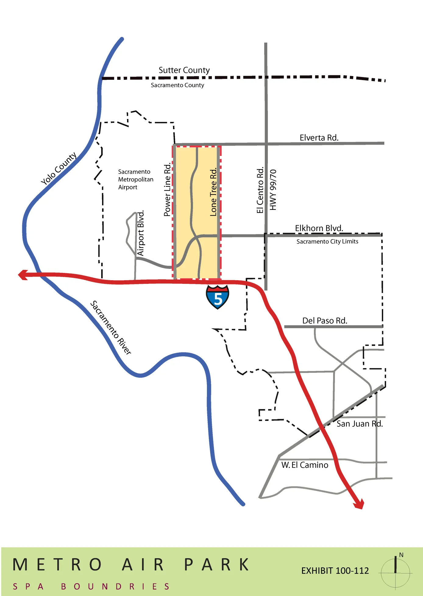
EXHIBIT 110-114 METRO AIR PARK SPA PROPOSED LAND USES
Section titled “EXHIBIT 110-114 METRO AIR PARK SPA PROPOSED LAND USES”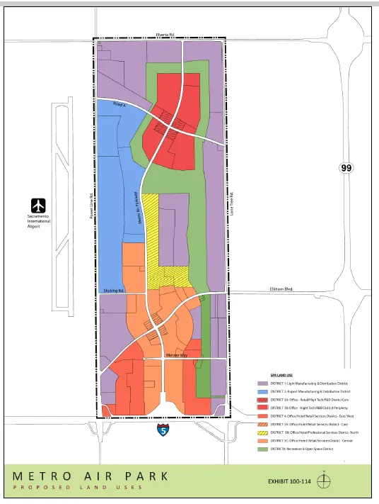
EXHIBIT 100-115 METRO AIR PARK CIRCULATION PLAN
Section titled “EXHIBIT 100-115 METRO AIR PARK CIRCULATION PLAN”[AMENDED 09-23-2022]
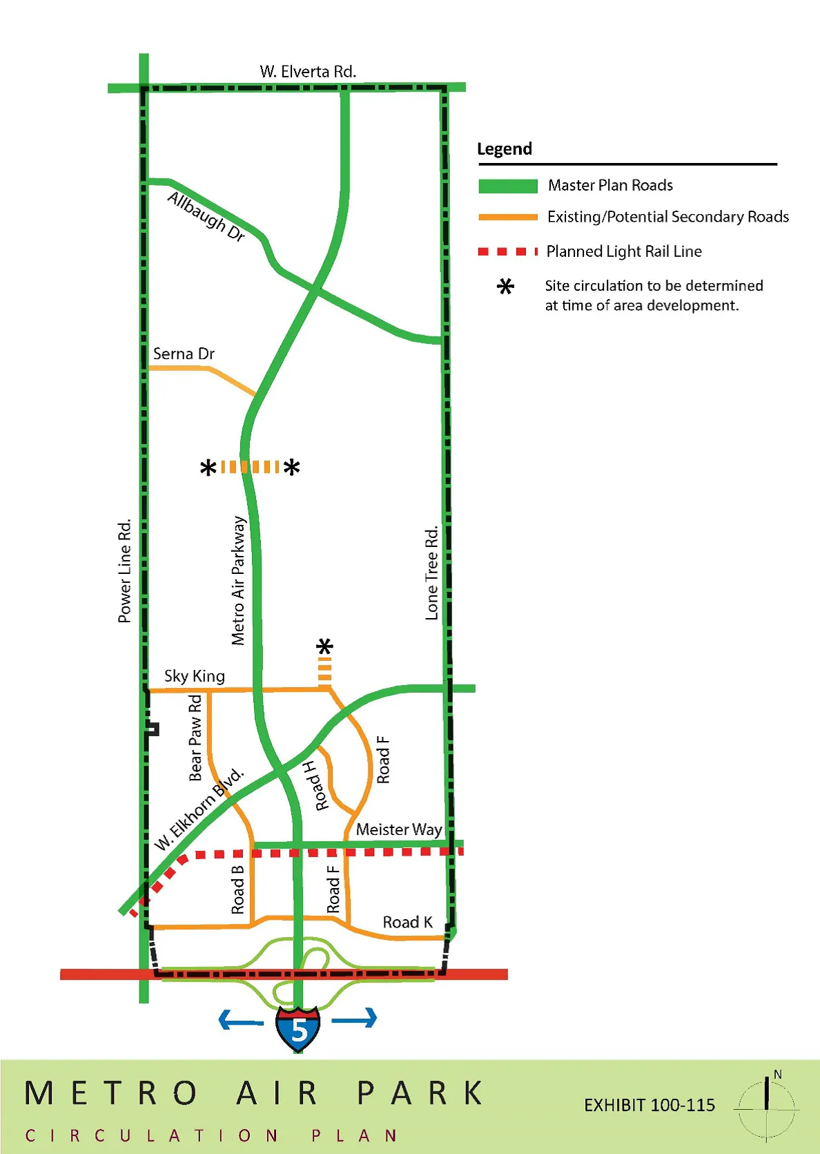
EXHIBIT 100-116 METRO AIR PARK LANDSCAPE & DESIGN GUIDELINES
Section titled “EXHIBIT 100-116 METRO AIR PARK LANDSCAPE & DESIGN GUIDELINES”Metro Air Park Land Use Plan
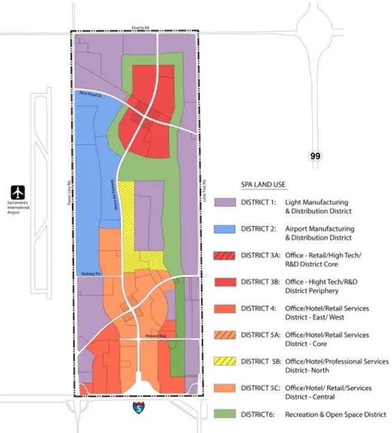
Regional Location
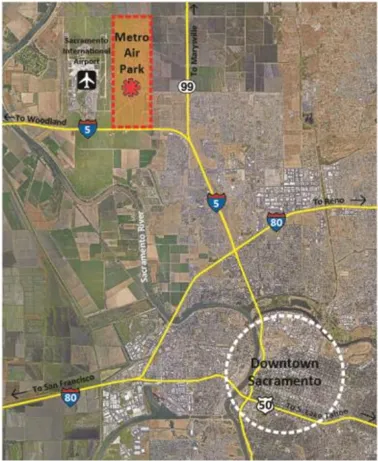
1.0 INTRODUCTION
Section titled “1.0 INTRODUCTION”Metro Air Park as approved by the County of Sacramento under ordinance #SZC 93-0045 created a Special Planning Area (SPA). The requirements of this SPA call for the preparation of Landscape and Design Guidelines to ensure a high-quality business park environment and the establishment of a landscape and lighting district which will provide funding for planting of open space areas, construction of project signage and streetscapes, and ongoing maintenance of common landscaped areas.
The Metro Air Park Landscape and Design Guidelines were prepared so that they will create a cohesive, well designed development. These Design Guidelines are to be used in conjunction with the standards for setbacks, building heights, and permitted and conditionally permitted uses contained in the SPA Ordinance. The Design Guidelines are intended to provide a framework for achieving the high-quality design of the building architecture and landscape design envisioned for the project. The guidelines are not intended to limit innovation, but rather to provide clear direction on design elements that are key to achieving the desired character. The detailed design criteria provided here will support planners, architects and landscape architects in meeting the intent of the SPA Ordinance.
A. Purpose
Section titled “A. Purpose”This document will be used to implement the general intent and spirit of the Metro Air Park Land Use Plan Summary Report as referenced in the SPA ordinance. As an implementation tool, these guidelines will encourage a distinct identity reflecting this project’s relationship to the airport and the orientation of parcels towards open space/recreation corridors. This plan acknowledges the mix of land uses approved by the Metro Air Park SPA Zoning Designation. The mix includes: Light Manufacturing and Distribution, Airport Manufacturing and Distribution, Professional and Corporate Offices, High Tech Research and Development, Commercial Uses and Recreation and Open Space.
B. Project Location
Section titled “B. Project Location”Metro Air Park is strategically located eight miles northwest of the City of Sacramento and directly east of Sacramento International Airport between Interstate 5 and Elverta Road, both of which connect to the Highway 99 to the east. Interstate 5 and Elverta Road/ Highway 99 provide excellent visibility into the development and access to a regional network of freeways serving the Central Valley and Northern California.
2.0 SUBMISSION REQUIREMENTS AND REVIEW PROCEDURES
Section titled “2.0 SUBMISSION REQUIREMENTS AND REVIEW PROCEDURES”The following sections describe the site plan process for Metro Air Park. It is the responsibility of the project lead, and/or developer to obtain all applicable permits and approvals from local governing agencies.
A. Developer Responsibilities
Section titled “A. Developer Responsibilities”The developer and/or tenant of individual parcels shall be responsible for the improvement and landscaping of the building site, including the parking lot, designated landscape setbacks along all public roads as well as the building. Landscape areas shall be planted in accordance with the landscaping guidelines set forth in this document. Maintenance of private property shall be provided by the property owner, while participation in the Landscape and Lighting District will provide for the planting and long-term maintenance of open space corridors and public rights-of-way .
B. FAA Review
Section titled “B. FAA Review”Concurrent with the Sacramento County Design Review process, the architect or applicant shall complete and submit Federal Aviation Administration (FAA) Form 7460-1 to the Northern California office. Design Review Approval will not be granted until reviewed/approved by the FAA.
C. Compliance with Air Quality Mitigation Plan
Section titled “C. Compliance with Air Quality Mitigation Plan”The applicant must demonstrate compliance with the Metro Air Park Master Air Quality Mitigation Plan (AQMP). To do so, the applicant is required to select mitigation measures from the AQMP to implement as part of the proposed development. The points value of the mitigation measures selected must add up to at least 15.
D. Metro Air Park Property Owners Association (MAPPOA) Architectural Review
Section titled “D. Metro Air Park Property Owners Association (MAPPOA) Architectural Review”Applicants or their representatives must submit a proposal to MAPPOA and gain written recommendation of the project site plan, architecture, and landscape architecture prior to submitting to County staff for any application process with Sacramento County. MAPPOA shall respond to architectural review proposals within fifteen (15) working days.
MAPPOA review is required for any new construction in Metro Air Park, including private parcels on public rights-of-way and easements. This requirement also applies to any exterior additions to buildings, facade and signage remodeling; all changes in building occupancy that question permitted land designations; projects dealing with drainage, walkway, corridor, plaza area, pedestrian and auto circulation patterns; vegetation, building, walk and/or structure replacement; all changes to parking structures and lots; or changes to or proposals for street furniture.
E. Required Plans for MAPPOA Architectural Review:
Section titled “E. Required Plans for MAPPOA Architectural Review:”- Site Plan
A site plan of the overall project shall be drawn to scale and submitted with the following information:
- Project address, assessors parcel number, and project title
- Scale and north arrow
- Dimensioned property lines, easements, rights-of-way and setbacks
- Square footage of buildings, hardscape, parking and landscape areas
- Building relationships, light illumination patterns, open space areas, circulation, walk and corridor connections
- All areas and/or architectural elements that are to be preserved
- Parking summary with required and proposed spaces provided
- Architectural Plans
Architectural floor plans and elevations shall be drawn to scale and submitted with the following information:
- Plans shall show all faces of the building and identify materials; colors, finishes and textures; proposed lighting fixtures; and signage elements and placement.
- Evacuation Plan
The proximity of Metro Air Park to the Sacramento International Airport warrants a plan of emergency evacuation from the site. In its many years of operation, the Sacramento International Airport has developed safety standards, techniques and procedures that have created a safe environment. However, for the utmost protection of the site’s daily inhabitants an emergency plan of evacuation shall be submitted. This plan of evacuation shall address and identify pedestrian exits to major corridors and out of the building and circulation routes to show efficient dispersal of traffic.
- Context Exhibits
In addition to the information required on architectural plans, photographs of the surrounding conditions shall also be submitted. When additions or alterations to existing buildings are planned, architectural plans should be clear how the addition or renovation will blend with the materials and colors of the existing building so that the line between new and old will be indiscernible.
- Signage
Detailed plans drawn to scale are required for the construction of all on-site signage elements. Submitted plans shall identify materials, textures, colors, lettering size, font style and illumination patterns consistent with these guidelines.
- Preliminary Design Review Landscape Plans
A full-sized landscape plan shall be submitted. Plans shall meet or exceed Sacramento County Code, see SPA Ordinance relating to water use and water conserving landscape requirements. The following items shall be included in the landscape submittal package:
- Address of the project and title
- Scale and north arrow
- Planting layout showing trees symbols at ¾ mature size
- Plant list and legend
- Table or callouts indicating species of all existing trees to remain and be removed
- Preliminary shade calculation in the County ’ s format demonstrating compliance with County requirements
- Dimensioned property lines, easements, rights-of-way and setbacks
- Square footages of landscape areas
- Proposed and/or existing structures
- Hardscape element locations, dimensions, heights, connections, materials finishes, textures and/or patterns
- All existing conditions and/or vegetation scheduled to be removed from the site shall be identified on the demolition plan. Existing items to remain shall be graphically distinguishable from items scheduled to be removed.
- Name, address, telephone number of licensed Landscape Architect with license number, expiration date, and signature.
Note: All elements of the landscape plans must be prepared by a California Registered Landscape Architect under the jurisdiction of the California Department of Consumer Affairs. Landscape and irrigation plans require additional review for compliance with water efficient landscape standards.
- Preliminary Grading Plan
A grading plan shall identify all existing and proposed contours, and proposed berming, slope gradients for all graded areas, and berm heights.
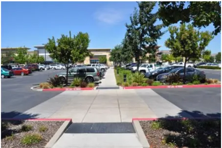
Landscaped drive aisles to direct vehicles and pedestrians
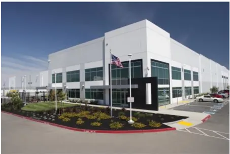
Orient office functions of buildings to face public streets
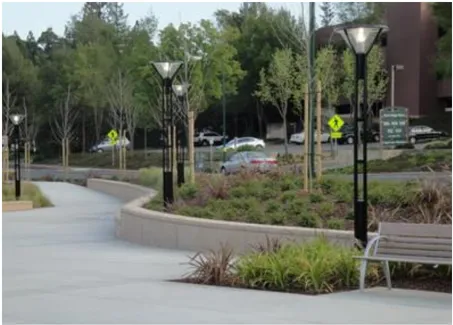
Provide pedestrian-scale lighting along walkways
3.0 SITE DEVELOPMENT GUIDELINES
Section titled “3.0 SITE DEVELOPMENT GUIDELINES”General Site Development Guidelines
Section titled “General Site Development Guidelines”The following General Site Development Guidelines are applicable to all development within each of the Land Use Districts. The guidelines are to be used in conjunction with the SPA Ordinance which provides the standards for setbacks, building height, intensity of development, and the permitted and conditionally permitted uses. Section 505-33 of the SPA Ordinance also outlines the Design Review process that will utilize these guidelines to evaluate development applications in order to make the necessary findings for project approval.
The goal of these design guidelines is to develop facilities that:
- Establish a sense of place for Metro Air Park through quality architecture and well-designed buildings.
- Guide the site planning and building orientation to capitalize on the location and unique opportunities each site presents.
- Establish a consistent landscape theme that creates a unifying design element for all projects within Metro Air Park.
- Provide flexibility to allow for a variety of development options and opportunities to generate jobs in Sacramento County.
Site Planning and Building Orientation Guidelines
Section titled “Site Planning and Building Orientation Guidelines”- Buildings located at corners and vehicle entries should frame the street and provide pedestrian connections between streets and buildings.
- Buildings should be oriented to include adequate setbacks to create public spaces.
- Main vehicle access drives should be oriented to terminate at the building entrances to provide visitors with a clear pathway to entries, wherever possible.
- Establish visual links in multi-building complexes by using landscaping and other site design elements that allow pedestrians to easily navigate within a complex of buildings.
- Site planning and parking lot design should consider travel speeds and view corridors from the freeway to businesses, placement of signage, and scale and location of special architectural features.
- Landscaping at site entries should support the character of the project and provide a sense of arrival. A variety of elements can be used to enhance entries, such as tenant monument signs, low ornamental walls or fences, or accent planting.
- Signage and landscape treatment should distinguish the entries that serve the main building from service entries.
- Service vehicle traffic should be separated from employee and visitor circulation, wherever possible. A clear travel route should be provided between the street and the building or complex entry.
- Provide for efficient site circulation by creating landscaped drive aisles that divide parking fields and direct vehicles to parking adjacent to buildings.
- Provide adequate stacking length at main entries and the first drive aisle to limit vehicle ingress and egress conflicts.
- The office portions of buildings should be oriented to the main public street or located at the building corner.
- Provide for vehicle circulation and parking in front of buildings. Buildings shall be set back a minimum of twenty-five feet (25’) to the face of the building.
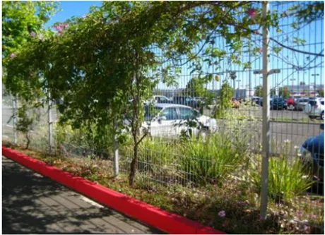
Utilize screen walls and/or landscaping to assist with concealing parking, loading docks, and service doors

Landscaped berms as screen in industrial area
Pedestrian Circulation
Section titled “Pedestrian Circulation”- Provide clear, convenient pedestrian connections to business entries from public streets, sidewalks, transit stops and trails.
- Distinguish pedestrian pathways from vehicular drive aisles through the use of differing paving textures, colors and/or materials. Where pedestrian pathways cross vehicular drives, provide clearly delineated crosswalks and consider raising the pedestrian paving surface for more visual differentiation.
- Provide adequate lighting for pedestrian safety.
- Design building footprints with offsets and recesses. Orient buildings to create courtyards and/or plazas to provide for a variety of gathering places.
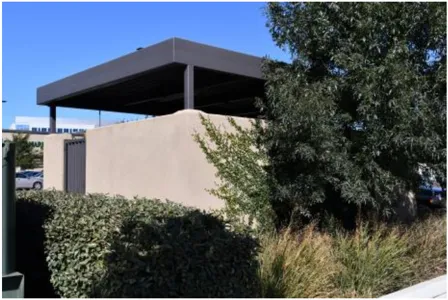
Screen trash enclosures from public rights-of-way
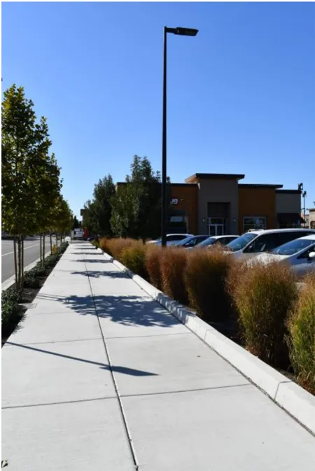
Screen parking with landscaping and berming where feasible
Screening and Utilities
Section titled “Screening and Utilities”- Loading docks, truck trailer parking and service doors are allowed to face public streets with the use of screening to include landscaping, berming, screen walls, or any combination of these methods to the extent possible.
- Parcels with more than one building should cluster buildings so that service doors and loading docks oppose each other to screen views from public streets.
- Utilize screen walls, fences, landscaping, and berming or any combination of these methods to provide proper screening of parking and loading docks to the extent possible.
- The following uses and equipment are required to be located behind building and/or well screened from public view:
- Auto/RV repair or storage
- Boat repair or storage
- Forklifts and other industrial equipment
- Construction equipment
- Storage of materials
- Site planning and utility design should anticipate to the extent feasible the location of above-ground improvements including, but not limited to, PG&E/ SMUD transformers, phone company boxes, fire department connections, backflow preventers, irrigation controllers, and other on-site utilities. Such utilities when visible from the public right of way shall be screened through the use of landscaping, berming, screen walls, or any combination of these methods to the extent possible.
- Trash enclosures should be designed with solid doors, interior concrete curbs, and exterior materials and colors shall be compatible with the adjacent building exteriors on a site. All trash enclosures shall be sized to fit all trash and recycling containers that will be necessary to serve the users of the site.
- Enclosed metal trash compactors adjacent to the loading docks should be screened from public view Screening can be accomplished through the use of landscaping, berming, screen walls, or any combination of these methods to the extent possible.
- Trash enclosures should be screened from view from all public rights-of-way by buildings and/or landscaping, and shall be located in a manner that allows for accessibility by the trash/recycling vehicles.
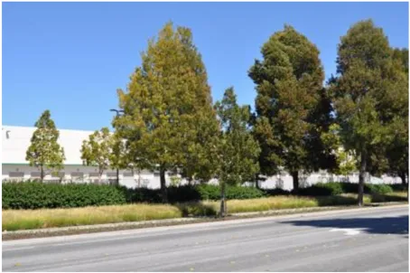
Screen loading docks with landscaping and/ or screen walls
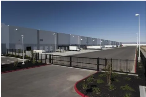
Provide separate entrances for trucks
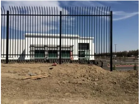
Tubular steel fencing example
Parking and Circulation
Section titled “Parking and Circulation”- Create a clear visual entry to the project by use of signage, entry walls, vertical landscape elements, and accent hardscape/paving.
- Parking located adjacent to public streets should be screened through the use of landscaping, berming, screen walls, or any combination of these methods to the extent possible.
- Large parking areas should include landscaped drive aisles that divide parking fields to provide clear circulation to parking adjacent to buildings.
Parking Lots
Section titled “Parking Lots”- Tree planting in parking areas should create shading and soften the appearance of the parking lot. At least 50% of the paved parking stall area shall be shaded at tree maturity.
- Where practical, provide separate entrances for automobiles and trucks clearly marked to promote safe site circulation.
- Where landscape planters are parallel and adjacent to vehicular parking spaces in customer parking lots, the planter areas shall incorporate a twelve inch (12’) wide concrete curb along their perimeter that is adjacent to the parking space in order to allow access to vehicles without stepping into landscape planters.
- The Planning Commission may approve a reduction in off-street parking as part of the TSM measures intended to achieve a peak period commute rate of 1.5 persons per vehicle set forth in an adopted TSM plan.
Walls and Fences
Section titled “Walls and Fences”- Walls in highly visible areas next to public rights-of-way may be allowed under extenuating circumstances, such as site security.
- Walls and fences should be designed and constructed of high-quality materials compatible with the overall character of the architecture and landscape design. Permitted materials include pre-cast concrete walls, split-face masonry, stone or stone veneer, brick, tubular steel, wrought iron, or similar high-quality material. Vinyl-clad wire fencing is allowable in Districts 1 and 2.
- Fencing for property boundaries backing onto the Recreation and Open Space Corridor shall consist of tubular steel and can include tubular steel with security .
- Barbed wire, razor wire, integrated corrugated metal, electronically charged or plain exposed plastic concrete/PCC fences are permitted pursuant to Sacramento County Zoning Code requirements and are subject to a Minor Use Permit.
- Fencing shall be limited to a maximum height of eight feet (8 ’).
- In addition to landscaping and berming, walls and fences may be used to screen the entries to the service and loading dock function of the buildings.
- Gates for pedestrian and vehicular access to restricted areas that are visible from public areas (i.e., parking lots, drive aisles) shall be constructed of solid durable material, tubular steel, or similar material.
- All walls are to be structurally engineered and insured.
- Fencing and walls adjacent to streets shall be located outside of any PUE or PUPFE.
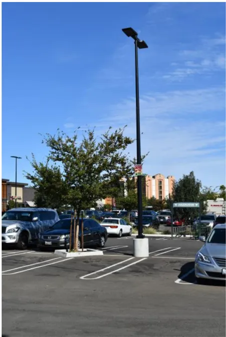
Lighting should be consistent with the scale and character of the project
Site Lighting
Section titled “Site Lighting”- Site lighting should highlight building entries, open spaces, walkways, and architectural features.
- Pedestrian lighting should be in scale with the pedestrian walkways to provide the necessary lighting through parking areas.
- Outdoor lighting and other means of illumination for signs, structures, landscaping, and similar areas, should be made of durable materials.
- Pole footings in traffic areas should be designed and installed to protect the light standard from potential vehicular damage.
- Lighting design along public rights-of-way should serve as a unifying element within Metro Air Park as well as provide wayfinding and safety for site users.
- Throughout the development warm white lighting is recommended. No bright colored, blinking or flashing lights will be allowed.
- Lighting elements should accent and highlight the area’s architectural features and pedestrian gathering areas, and provide up-lighting for landscape accent trees.
- Design and placement of lighting should minimize glare onto adjacent properties, buildings, and rights-of-way .
- If neon lighting is to be used in corporate signage design, it shall be limited to single illumination and/or incorporated in corporate graphics. Flashing neon and regular illuminating lights will not be allowed.
- Concrete footings are required for light fixtures placed in planting areas and shall be constructed flush with the ground plane. For poles mounted in parking lots, footings/bases shall extend two feet (2’) above a paved surface. Electrical utility and service connections shall be located below grade.
- Light standards are limited to a maximum height of thirty feet (30’) for roadways with an eighty-four foot (84’) right-of-way or larger street, and thirty feet (30’) for other pole mounted light fixtures. A minimum of sixteen feet (16’) of clearance shall be provided over all public roadways.
- Trees shall be selectively pruned around light sources to allow for nighttime security illumination. For additional tree pruning information, refer to the Landscape Maintenance section of the Design Guidelines.
- The lighting design shall provide a horizontal luminance on pavement of a minimum 0.8 foot-candles with a lighting maximum uniformity ratio of 6 to 1 for parking and pedestrian areas.
- Interior ambient lighting from architectural sources that spills into outdoor spaces shall be allowed.
- Lighting at building entrances shall provide a minimum of 5.0 foot-candles.
- Holiday lighting may be used for winter holiday display, starting in mid-November and shall be removed by mid-January.
- To provide maximum safety for pedestrian and vehicular movement along travel ways, lighting shall meet the requirements of Sacramento County. A concentration of light sources shall be focused on intersections, crosswalks, pedestrian travel ways and connections.
- For all pedestrian travel ways, the maximum height of light fixtures shall be twenty feet (20’) with a minimum clearance of ten feet (10’) provided above walkways.
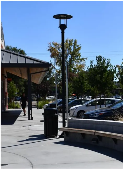
Use lighting to accent pedestrian areas
Parking Lot Lighting
Section titled “Parking Lot Lighting”- Specific area developments should use lighting elements that complement the development or building theme.
- For all parking areas the maximum height of light fixtures shall be forty feet (40’) with a minimum clearance of ten feet (10’) provided above parking stalls and pedestrian connections.
- Lighting bases/footings that accent adjacent architecture shall be used. To protect the lighting fixtures a twenty-four (24“) base footing shall be used where a vertical curb does not separate the light standard from parking areas.
- Parking areas should have adequate illumination for safety and security. Parking lot lighting fixtures should avoid conflict with tree planting locations.
- Parking lot lighting should be architecturally compatible with the building and site design. Lighting should be low profile and in scale with the setting and may include post lights and/or light bollards.
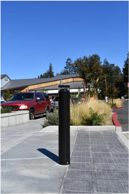
Provide lighting for pedestrian safety
Plaza Area Lighting
Section titled “Plaza Area Lighting”- Plaza and open area lighting is important to allow safe nighttime activity.
- Plaza area lighting should be predominately positioned downward and located to prevent excessive illumination onto adjacent buildings and properties.
- Bases for pole mounted fixtures shall be flush with the ground plane.
- All electrical services to the light fixtures shall be located underground.
- Services to wall mounted fixtures shall be located behind the fixture itself. No external electrical service connections shall be allowed.
- Plaza area lighting may include low voltage fixtures.
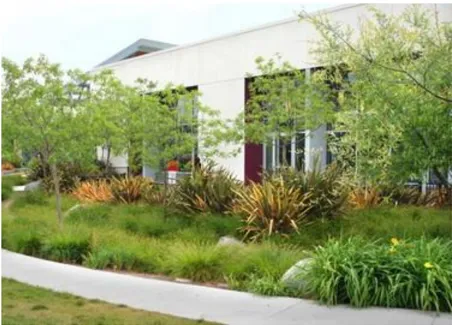
Climate landscape planting
4.0 ON-SITE LANDSCAPE GUIDELINES
Section titled “4.0 ON-SITE LANDSCAPE GUIDELINES”Landscape design plays an important role in creating a uniquely attractive, sustainable and health-promoting environment for Metro Air Park. Additionally, thematic signage, coordinated furnishings and fixtures, and enhanced hardscape and plant palettes work together to create a ’sense of place. ’Native and climate-adapted plantings shall be planted in clean, simple designs creating a sophisticated and contemporary character.
The landscape guidelines are intended to provide a framework for achieving the high-quality landscape character envisioned for Metro Air Park. The guidelines are not intended to limit innovation, but rather to provide clear direction on design elements that are key to achieving the desired character. The detailed design criteria provided here will support planners, architects and landscape architects in meeting the intent of the Special Planning Area.
- Fast-growing trees should be closely spaced in groupings to create visual mass.
- Planting areas should be provided between parking and roads to provide visual relief in large expanses of hardscape .
- Screening and sound attenuation along roads should be achieved through the use of landscaping, berming, screen walls, or any combination of these methods to the extent possible.
- Design should be generally consistent with the overall contemporary character of the project.
- Landscape designs with simple plant palettes, such as rows and masses of native and climate adapted grasses and tree plantings are encouraged. There should be a consistency of landscape design throughout a development. Unrelated random placement of plant materials should be avoided.
- Sites should be landscaped in order to optimize the aesthetic appeal and comfort for employees and visitors. All portions of a site not devoted to buildings, structures, parking, outdoor storage or paving should be landscaped, to the extent feasible. Landscapes should be designed to reach a reasonable level of maturity within five years.
- Parking lot trees should be provided at a minimum of one tree per eight (8) parking stalls. Trees may be clustered to define circulation routes, frame site views, and reinforce freeway edge planting. Large scale, high branching shade trees should be used in all parking areas.
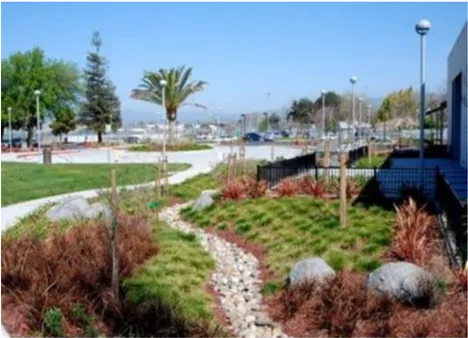
Simple designs of native and climate landscape elements
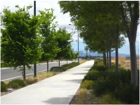
Landscape strip, sidewalk, landscape setback planting
Figure 1 - Level Screening Concept
Section titled “Figure 1 - Level Screening Concept”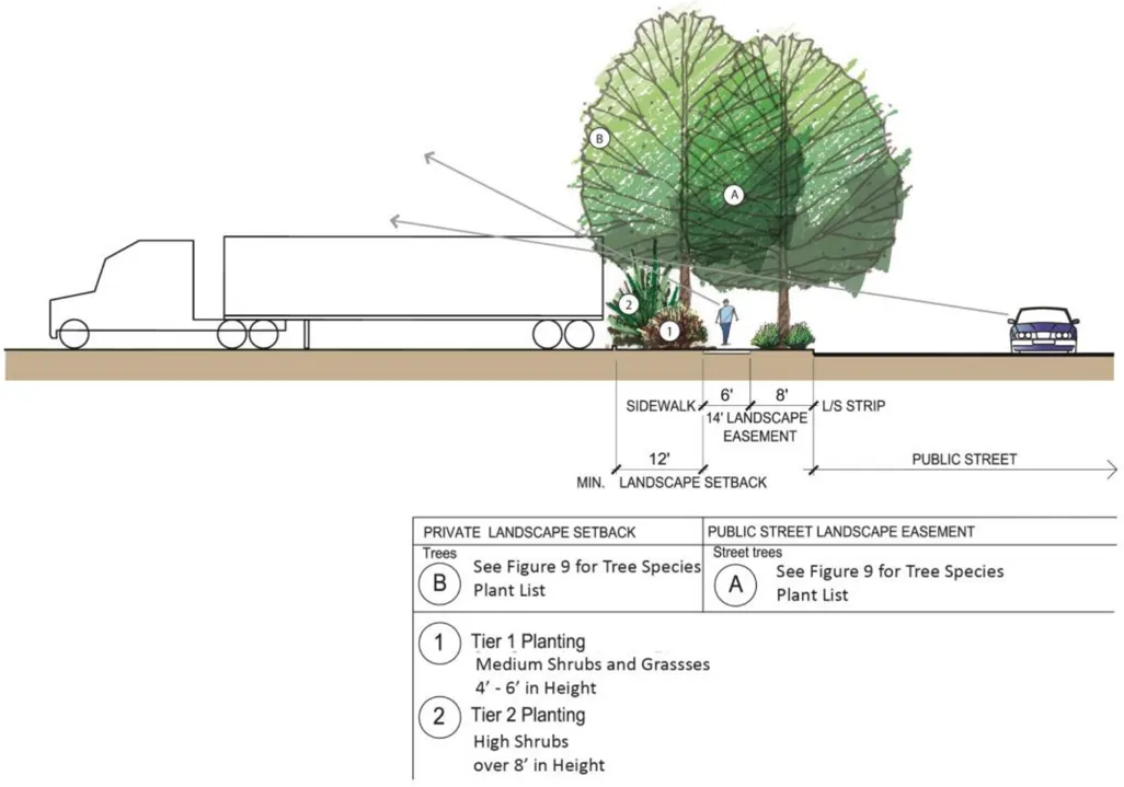
Figure 2 - Down-slope Screening Concept
Section titled “Figure 2 - Down-slope Screening Concept”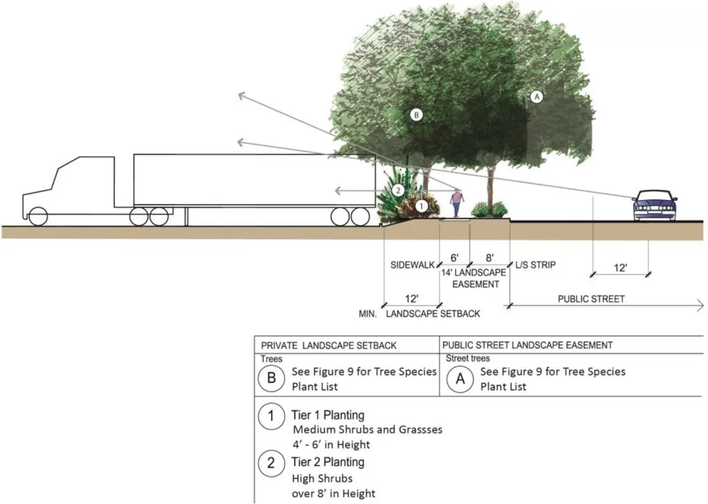
Figure 3 - Up-slope Screening Concept
Section titled “Figure 3 - Up-slope Screening Concept”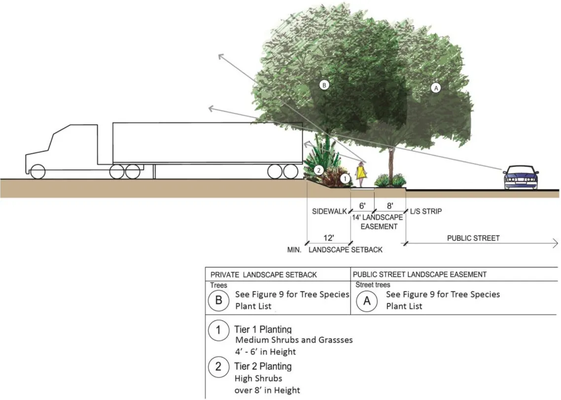
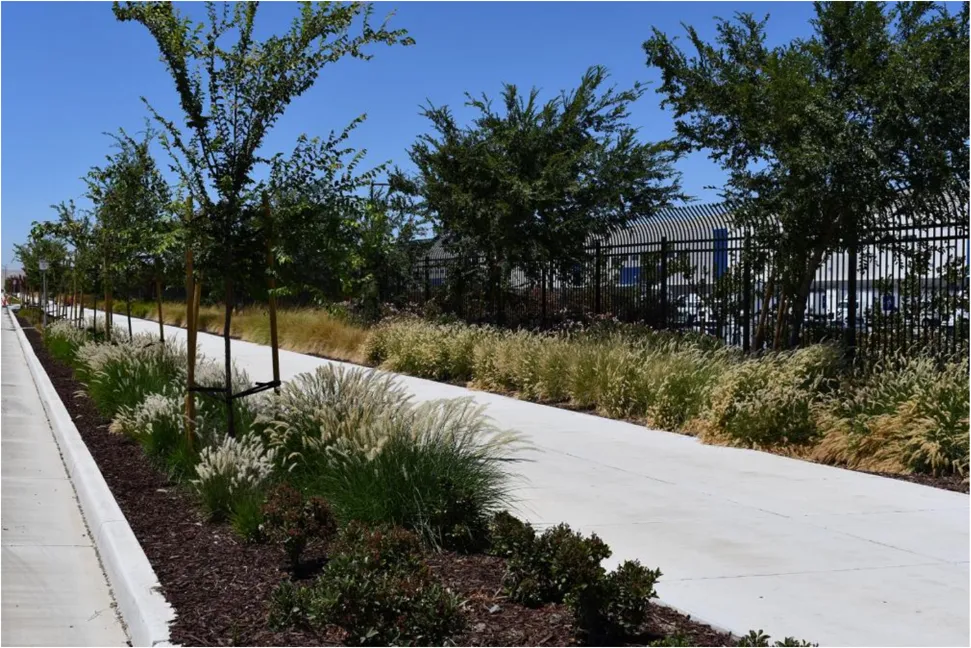
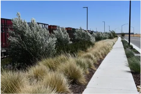
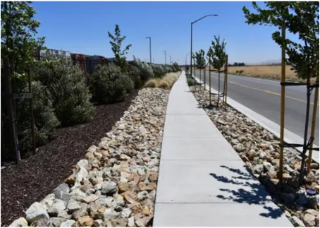
Landscape Screening at Street Edges
Materials
Section titled “Materials”- Natural materials that promote the general character of the project are preferred, such as stone and wood.
- The use of native, climate-adapted, and large stature species is encouraged to promote/create habitat, minimize use of water, fertilizers and pesticides, and promote biodiversity.
- Species listed on the CAL-IPC list of invasive species shall not be used in the landscape.
- Turf should be minimized in the landscape, except where required for recreational purposes. The use of turf for solely decorative purposes is strongly discouraged.
- Stormwater Best Management Practices, such as bioswales, should be incorporated into the landscape to maximize on-site infiltration of stormwater, to the extent possible.
Screening
Section titled “Screening”- Parking lots and truck loading areas adjacent to and visible from public streets should be screened from view through the use of landscaping, berming, screen walls, or any combination of these methods to the extent possible, see Figures 1, 2, and 3.
Sustainability
Section titled “Sustainability”- Sustainable landscape design that employs the most current technologies is strongly encouraged.
- Appropriate placement of landscape materials should provide summer shade on buildings, parking spaces, drives, and paths.
- Enhanced building entries and other special landscape features are encouraged and should feature bold foliage accent planting in pots or planters, colored paving, spreading shade trees and seating elements.
- Large-scale trees and shrubs appropriate to the scale of the architecture should be emphasized to minimize visual dominance of large architecture.
Site Furnishings
Section titled “Site Furnishings”- Site furnishings, including bus shelters, benches, trash receptacles, bollards and other elements shall be coordinated with buildings and other structural streetscape features through similar materials and style.
- Site furnishings should be high-quality and contemporary in design and compatible with the overall landscape design.
- Site furnishings should be durable and vandal resistant.
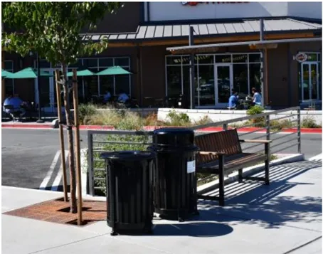
Durable and vandal-resistant site furnishings
5.0 RECREATION AND OPEN SPACE REQUIREMENTS
Section titled “5.0 RECREATION AND OPEN SPACE REQUIREMENTS”A recreation and open space corridor has been designated within Metro Air Park to create a multi-use corridor that allows for a system of interconnecting buffers and green areas. Off-street pedestrian walkways and/or trails will provide connections between uses. Plazas and courtyards are encouraged to emphasize and take advantage of the open space orientation of this project. The recreation corridor north of EIkhorn Boulevard will contain recreational trails and it is uncertain whether the I8-hole golf course and other associated improvements will be included as part of the corridor improvements.
It is envisioned that the recreation and open space corridor shall be developed in coordination with the storm drainage system requirements. An informal design character is encouraged with naturalistic groves of trees and understory plantings that thrive within the designated stormwater treatment areas and provide dense vegetation to screen adjacent land uses. For a list of approved plant materials refer to Appendix A.
The golf course if included as part of the recreation and open space corridor will be located on the east side of Metro Air Parkway. The front nine holes of the course will have a double fairway and the back nine holes will be designed as a “looping” single fairway course.
The corridor south of Elkhorn Boulevard will provide natural open space, incorporating recreation trails and wetland areas. Landscaping along the open space/recreation corridors will be designed and installed to create a cohesive and uniform background for key architectural elements.
Typical Open Space Corridor
Transition to Open Space
Incorporate Trail Linkages to Open Space
Provide Bike Trail Linkages
Transition to Open Space
Section titled “Transition to Open Space”Landscaping shall be concentrated along the property boundary between the recreation and open space corridor and the private development to create a buffer and transition between the built environment. Landscaping will include informal plantings of trees and shrubs clustered along this edge to assist with providing screening of adjacent development and vehicle parking.
The office component of industrial buildings, key entries or pedestrian areas such as lunch rooms or plazas are encouraged to connect with the open and provide trail linkages. The open space corridor will provide a system of recreational trails that aid in pedestrian circulation and lessen automobile reliance within Metro Air Park corridor extensions will meander to and through adjacent entrances and use zones, creating a campus-like setting.
Utilize consistent detailing, materials, and color palettes on all building elevations
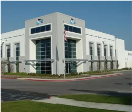
Design buildings with recessed entries and windows
Bicycle Lanes and Pedestrian Pathways
Section titled “Bicycle Lanes and Pedestrian Pathways”In addition to the bicycle lanes provided in the streets throughout Metro Air Park and the pedestrian walkways located adjacent to streets, a system of trails shall be provided in the recreation and open space corridor. Trails or pathways may be used by either pedestrians or bicyclists within the corridor. Golf carts may be provided with a separately designated circulation system within the golf course to avoid the potential conflicts between pedestrians and golfing activity. Trails will be sized and designed to accommodate a multi-use function. Creating separate but parallel trails in immediate proximity to each other (within thirty feet (30’) would result in the unnecessary duplication of trails shall be avoided. An eight foot (8’) bike/pedestrian trail with a two foot (2’) decomposed granite shoulder on each side of the pavement shall be provided through the recreation and open space corridor.
6.0 BUILDING DESIGN GUIDELINES: ALL DISTRICTS
Section titled “6.0 BUILDING DESIGN GUIDELINES: ALL DISTRICTS”The architectural design guidelines are intended to provide direction for the development of well-designed structures through the use of high-quality materials and attention to detail that will meet or exceed the high standards envisioned for Metro Air Park. These guidelines will assist in ensuring a base level of quality of architecture consistent with the vision and goals of the SPA Ordinance.
- Building base materials may consist of, but not be limited to, wood, stucco, stone, brick, concrete or slump block, and concrete tilt-up panels. Accent materials may consist of, but not be limited to, tile, glass, stone, brick, wood, stucco and metal. All buildings should utilize a variety of colors and materials.
- Visual interest on buildings with simple shapes shall be provided through the use of both vertical and horizontal façade breaks that should be visible from street view, including, but not limited to, varying roof heights and pitches, stepped out columns, awnings, windows, recessed entries, score lines, and a mix of colors and materials.
- The use of architectural elements such as recessed entries and windows, columns and walls shall be balanced to create visually interesting structures.
- Each structure on a particular site should have consistent architectural details and design elements to create a visually cohesive development. It is not necessary or desirable for buildings to ’match ’, but they should utilize similar architectural elements, colors and materials, or styles.
- Exterior materials for buildings should reflect and expand on the character of Sacramento and reflect a contemporary image.
- Utilitarian portions of buildings, such as vents, gutters, downspouts, flashing, electrical conduit, and other wall-mounted utilities shall be painted to match the color of the adjacent surface or otherwise designed in harmony with the building exterior.
- All buildings shall be designed to completely screen any roof-mounted equipment, including, but not limited to, HVAC units, vents, fans, antennas, sky lights, and dishes from public view. Parapets on flat roofs shall be high enough to hide roof top equipment from the pedestrian level.
- Windows on structures shall line up with adjacent windows to create design consistency and express human scale.
- Windows facing south or west should be recessed or incorporate shade structures and/ or shading from trees. Shade structures should be visually consistent across all windows, and the design should be contextually appropriate for the building
- Building entrances should be architecturally apparent, visible from the street, and accessible from parking lots.
- Balconies or terraces on multi-story buildings are encouraged to add visual interest and create environments conducive to a variety of uses.
- All sides of a building shall receive the same level of detail and architectural enrichment. Loading or distributing areas may provide less detail if effectively screened from public view.
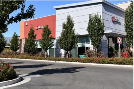
Screen roof top equipment from public streets
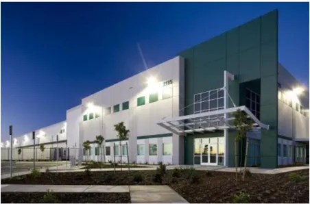
Office functions should face the street
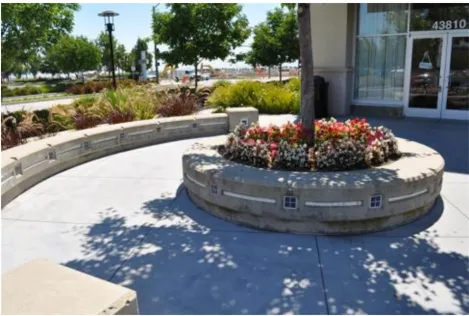
Include public spaces and plazas in the site design
Safety Guidelines:
Section titled “Safety Guidelines:”- A 24-hour private security service will monitor and provide police service to the Metro Air Park development. Included with this service, each tenant shall be provided with the name, phone number and on-site address of the security firm providing the safety service.
- A dialogue with the Sheriff’s Department Crime Prevention Unit shall be established by the tenant’s architect/designer and security service to ensure the implementation of appropriate crime prevention construction and design.
- Provide one acre of land for a fire protection facility. The exact facility, location and timing thereof, equipment and operating costs to be provided shall be determined in the Public Facilities Finance Plan (PFFP) to be approved by the Board of Supervisors.
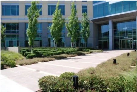
Establish visual links to building entries
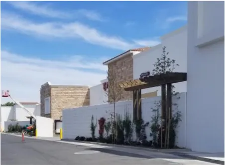
Include Recesses and Change in Materials
Noise Attenuation
Section titled “Noise Attenuation”- Special consideration shall be given to noise attenuation due to Metro Air Park’s proximity to the Sacramento International Airport and runway facilities. Interior noise levels of buildings within Metro Air Park shall be a maximum of 45 decibels. During the construction documents phase, the project applicant shall submit to the Sacramento County Planning and Environmental Review identification of design measures that will reduce interior noise levels of the proposed building(s).
- All noise attenuation measures shall utilize approved industrial standards and pose no harmful impacts to the surrounding environment and building occupants.
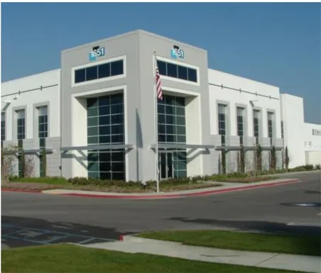
Design buildings with recessed entries and windows
7.0 I-5 FRONTAGE GUIDELINES
Section titled “7.0 I-5 FRONTAGE GUIDELINES”As the ‘front door’ to Metro Air Park, the I-5 corridor freeway edge provides opportunities for highly visible freeway development. The vision is to create a strong thematic entry and gateway to the project from I-5 at Metro Air Parkway, and create a development fabric of well-designed buildings that are oriented to the freeway that will establish a visually interesting project edge. The following guidelines have been established to guide development of parcels along the I-5 project frontage, and apply to parcels in any District with I-5 frontage.
- Building architecture should include additional articulation including offsets and recesses, change in heights of roof/parapet and wall design, and change in materials and colors.
- Site planning should provide for berming and variation in plant palette and height of the landscape buffer adjacent to I-5 for the 25’ minimum buffer required from the property boundary.
- Landscaping of the 25’ minimum buffer area parallel to I-5 shall adhere to the concept plan of trees and shrub planting in masses as depicted in Figure 7.
- Parking and/or frontage/access driveways should be located adjacent to the freeway to create a greater building setback from the property line at I-5 to assist in reducing the visual massing of buildings.
- Screen walls shall be utilized to obscure views of interior service doors and loading docks.
- Screening should be designed and constructed of materials complementary to the primary building.
- Trash enclosures, compactors, and truck courts are not allowed to face I-5 unless they are screened from view with screen walls and landscaping or combination of both.
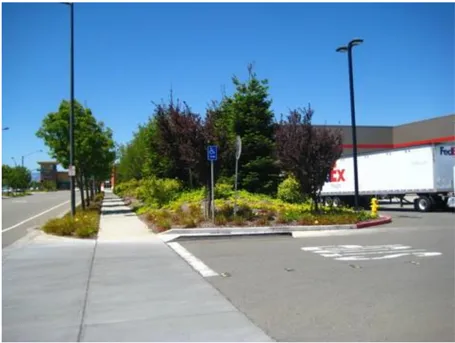
Landscaping to screen loading docks
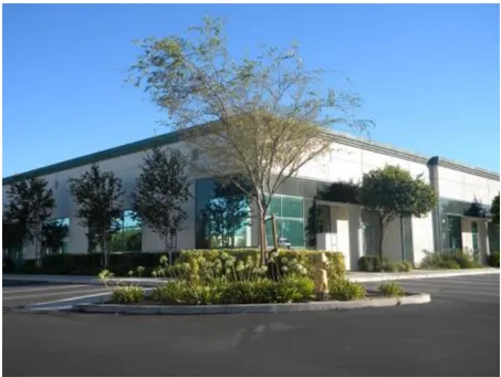
Typical high tech/commercial building example
8.0 DISTRICTS 1 & 2: LIGHT MANUFACTURING, DISTRIBUTION, AND AIRPORT MANUFACTURING AND DISTRIBUTION DESIGN GUIDELINES
Section titled “8.0 DISTRICTS 1 & 2: LIGHT MANUFACTURING, DISTRIBUTION, AND AIRPORT MANUFACTURING AND DISTRIBUTION DESIGN GUIDELINES”Manufacturing, Distribution, and Airport Related industries will generally consist of large parcels that will allow for large buildings. Buildings should be designed to face office functions and building entries to the street and provide screening of truck and trailer parking, loading docks, and service doors, as defined below.
- Buildings should be setback from the property line to allow for employee and customer parking adjacent to the building.
- Buildings with an office function should be oriented to the main public street or located at the building corner, wherever possible.
- Parcels with more than one building should cluster buildings so that service doors and loading docks oppose each other to screen views from public streets.
- Include landscaping to reduce the visibility of the loading docks, truck trailer parking, and service doors from public streets.
- Parking located adjacent to streets shall be screened from view by the siting of buildings and through the use of landscaping, berming, screen walls, or any combination of these methods to the extent possible.
- Where possible, provide separate entrances for automobiles and trucks clearly marked to promote safe site circulation. In some cases, shared vehicle access may be necessary.
- Parking areas for truck trailer parking are allowed to face public streets with the use of screening to include landscaping, berming, screen walls, or any combination of these methods to the extent possible.
- Allow for adequate truck stacking length at the street entry and any security buildings to limit conflicts with site circulation.
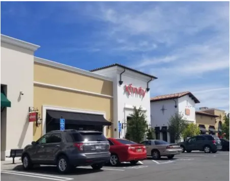
Retail Services Example
9.0 DISTRICTS 3A & 3B: OFFICE-RETAIL/ HIGH TECH/R&D DESIGN GUIDELINES
Section titled “9.0 DISTRICTS 3A & 3B: OFFICE-RETAIL/ HIGH TECH/R&D DESIGN GUIDELINES”Development will be allowed to be multiple stories in height and will frame the streets and corners. Parking is encouraged to be located behind buildings and screened with landscaping and berming.
- Buildings at corners and vehicle entries should frame the street and include plazas or gateway openings and pedestrian connections between the street and the campus of buildings.
- Buildings should be oriented to include adequate setbacks to create public spaces and plazas.
- Establish visual links in multi-building complexes by using landscaping and other site design elements that allow pedestrians to easily navigate within a complex of office buildings.
- Large parking areas should include dedicated landscaped drive aisles that divide parking fields to provide clear circulation to parking adjacent to buildings.
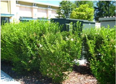
Utility equipment screened with planting
10.0 DISTRICTS 4, 5A, 5B, & 5C: OFFICE/HOTEL/RETAIL/PROFESSIONAL SERVICES DESIGN GUIDELINES
Section titled “10.0 DISTRICTS 4, 5A, 5B, & 5C: OFFICE/HOTEL/RETAIL/PROFESSIONAL SERVICES DESIGN GUIDELINES”Note: Industrial uses proposed in Districts 4 and 5 shall comply with Design Guidelines listed under Section 8.0 above, rather than the guidelines in this section.
- Buildings should be oriented to face the primary highway/street frontage and/or entry drives to maximize exposure for businesses.
- Parking should be located behind buildings and/or screened with landscaping and berming.
- Drive aisles should be oriented perpendicular to the buildings to provide for easy pedestrian access to the buildings. In large commercial developments, a pedestrian pathway should be incorporated into the parking field to provide a linkage and clear pathway for safe pedestrian access between buildings.
- Buildings should be clustered to create plazas, and framed spaces for seating, fountains and other design amenities.
- Building facades can be oriented to face either the freeway frontage or the main public street so that businesses and commercial uses are highly visible.
- Vehicle parking fronting a street shall be screened through the use of landscaping, berming, screen walls, or any combination of these methods to the extent possible.
- Building footprints shall be designed with offsets and recesses. Orient buildings to create courtyards, and/or plazas to provide for a variety of gathering places.
- Trash enclosures shall be screened from public streets with landscape and green screen walls and located to allow for collection vehicle turning and access.
- Site planning and utility design shall anticipate to the extent feasible the location of above-ground improvements including, but not limited to, PG&E transformers, phone company boxes, fire department connections, backflow preventers, irrigation controllers, and other on-site utilities. Such utilities when visible from the public right of way shall be screened through the use of landscaping, berming, screen walls, or any combination of these methods to the extent possible.
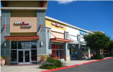
Wall mounted signage example
Figure 4 - Sign Locations
Section titled “Figure 4 - Sign Locations”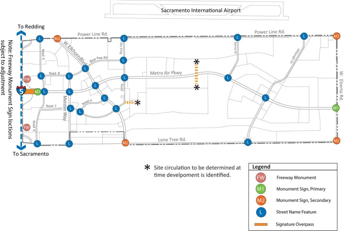
11.0 MASTER SIGNAGE PROGRAM
Section titled “11.0 MASTER SIGNAGE PROGRAM”Consistent application of sign criteria will be utilized throughout Metro Air Park. The guidelines below establish a hierarchy of criteria to regulate and control the size, location, type and quality of signage. The intent of these guidelines is to create a consistent identity and branding for Metro Air Park that provides uniform wayfinding and vehicle circulation with clear points of entry to individual developments throughout the plan area.
General Guidelines
Section titled “General Guidelines”- Individual tenant and wayfinding signage can be located within the required landscape setbacks provided that it is not located in conflict with the sight distance requirements for Sacramento County Engineering.
- Signage shall be of professional quality, utilizing high quality and durable materials and finishes.
- All signs shall be maintained in good condition, including the display surface. Signage shall be legible, and kept clean and free of graffiti and/or other disfigurement.
Freeway/Commercial & Primary and Secondary Monument Signage Materials & Colors
Section titled “Freeway/Commercial & Primary and Secondary Monument Signage Materials & Colors”- Aluminum constructed pole cover painted to match to color below.
- Aluminum bullnose painted silver to match color below.
- Pan channel logo/ white plexiglass face with orange vinyl overlay, aluminum returns painted silver. Internal white LED illumination.
- Aluminum tenant cabinets painted silver, rout out tenant copy and font (TBD), white plexiglass backer with dark grey color vinyl overlay. Internal white LED illumination.
- Pan channel letters / white plexiglass face, aluminum returns painted silver. Internal white LED illumination.
- Pan channel letters / white plexiglass face with orange vinyl overlay, aluminum returns painted silver. Internal white LED illumination.
- Aluminum base / paint and textcoat grey.
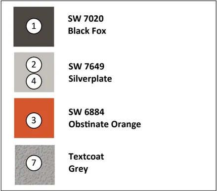
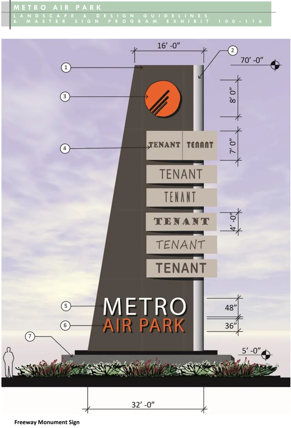
- All signage shall be designed free of bracing, angle-iron, guy wire, cables and/or similar devices.
- Structures that accommodate several tenants shall utilize a single monument sign that identifies the overall project name and individual tenants.
- Color palettes shall match the material and colors shown for the various signage types to achieve project consistency.
- The height and width of all signs shall be measured from the highest and widest point of the sign and the area of signs shall be calculated from the height and width of the sign surface.
- Corporate logos and font styles with a single color scheme are allowed for all signs in public rights-of-way.
- All signs shall conform to these standards and shall be approved by MAPPOA prior to submittal to Sacramento County .
- Signs shall be located as per the Signage Plan; see Figures 4, 5, and 6.
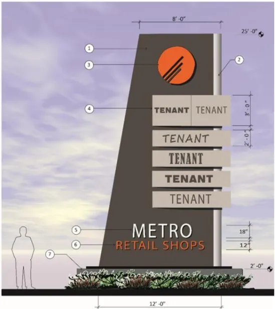
Commercial Retail Monument Sign
Metro Air Park Master Signage Program
Section titled “Metro Air Park Master Signage Program”The guidelines below shall regulate the location, development and maintenance of permanent directory and monument signage Air Park. The hierarchy of signs are as follows:
Freeway Monument Sign
Section titled “Freeway Monument Sign”- Two Freeway Monument signs will identify Metro Air Park from I-5 near the east and west property boundaries and adjacent to I-5; see Figure 4.
- The maximum height of the signage wall shall be a 70 feet.
- The maximum area of a directory sign shall not exceed 3,000 square feet.
- The dimension and design of the signage shall be consistent with the Freeway Monument Signage depicted.
- Corporate logos and font styles are allowed in a dark grey color as part of the tenant panels.
- The signage shall be limited to the identification of “Metro Air Park” and the commercial retail tenants only.
- Accent lighting should be concealed behind the text or located flush with grade to provide up lighting.
- Vegetation used in these areas should be developed in a hierarchy and planted in groupings to make strong highlighting statements that will serve as a backdrop and accent the signage.
- See Freeway/Commercial & Primary and Secondary Monument Signage Materials & Colors.
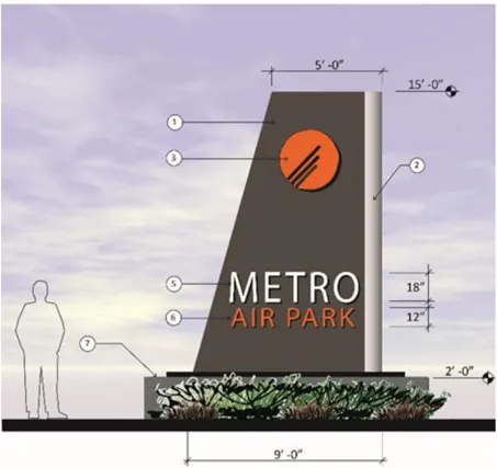
Primary Monument Sign
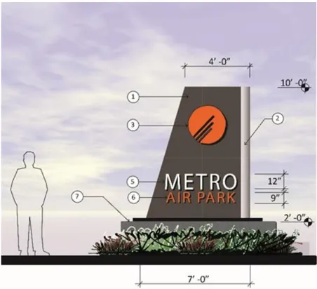
Secondary Monument Sign
Commercial Retail Monument Sign
Section titled “Commercial Retail Monument Sign”The Commercial Monument sign will denote the main project entry and tenants within a typical large format retail shopping center. The design is similar to the Freeway and Monument signage in creating a uniform look of the signage for the various retail uses.
- The maximum area of a directory sign shall be 300 square feet.
- Computation of Area. Freestanding signs are to be computed as total height by the total length of the sign or signs for one side for double faced signs, excluding framework of separate single wood post or masonry column and single wood or masonry beam. The base of a monument sign is not part of the sign when of wood or masonry.
- Freestanding signs that are spread with three faces shall be computed by the greater of either the area of one side, or the projected area of two or three sides.
- Freestanding signs that are four sided shall be computed by the greater of either the area of two sides or the projected area of two sides.
- Commercial retail monument signs shall be located so that the part of the sign located closest to the street right-of-way line, including supporting structure, shall be set back not less than 10 feet (If PUPF easement: 16 feet) from existing public street improvements or right-of-way line.
- The maximum height of a directory freestanding sign shall be 25 feet .
- The dimension and design of the signage shall be consistent with the Commercial Retail Monument Signage. depicted.
- Corporate logos and font styles are allowed in a dark grey color as part of the tenant panels.
- Accent lighting shall be concealed behind the text or located flush with grade to be used as signage up-lighting.
- See Freeway/Commercial & Primary and Secondary Monument signage materials and colors.
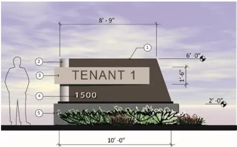
Tenant Monument Sign-Single Tenant
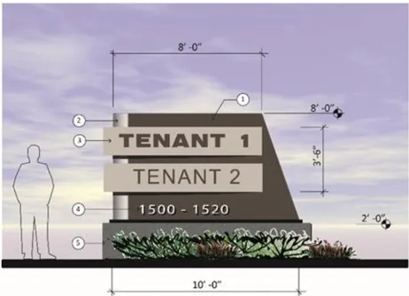
Tenant Monument Sign-Two Tenant
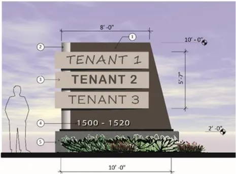
Tenant Monument Sign-Three Tenant
Primary Monument Sign
Section titled “Primary Monument Sign”- Primary monument signs will identify Metro Air Park at its primary entrances; see Figure 4.
- The maximum height of the signage wall shall be 15 feet.
- The dimensions and design of the signage shall be consistent with the Primary Monument Sign depicted.
- The gateway/entrance monument signage shall be limited to the identification of “Metro Air Park” only.
- Accent lighting shall be concealed behind the text or located flush with grade to provide up-lighting.
- Vegetation used in these areas should be developed in a hierarchy and planted in groupings to make strong highlighting statements that will serve as a backdrop and accent the monument signage.
- See Freeway/Commercial & Primary and Secondary Monument Signage Materials and Colors.
Secondary Monument Sign
Section titled “Secondary Monument Sign”- Secondary Monument Signs will identify Metro Air Park at its secondary entrances; see Figure 4.
- The maximum height of the signage wall shall be a 10 feet.
- The dimensions and design of the signage shall be consistent with the Secondary Monument Sign depicted.
- Secondary Monument Signs will be symmetrically placed at corners as specified for the intersection, except where the corner is located off-site.
- Accent lighting should be concealed behind the text or located flush with grade to be used as signage up-lighting.
- Vegetation used in these areas should be developed in a hierarchy and planted in groupings to make strong highlighting statements that will serve as a backdrop and accent the monument signage.
- See Freeway/Commercial & Primary and Secondary Monument Signage Materials and Colors.
Tenant Monument Signage Materials & Colors
Section titled “Tenant Monument Signage Materials & Colors”- Aluminum constructed pole cover painted to match to color below.
- Aluminum bullnose painted silver to match color below.
- Aluminum tenant cabinets painted silver, rout out tenant copy and font (TBD), white plexiglass backer with dark grey color vinyl overlay. Internal white LED illumination.
- Rout out push thru white plexiglass address numbers / Internal white LED illumination.
- Aluminum base / paint and textcoat grey
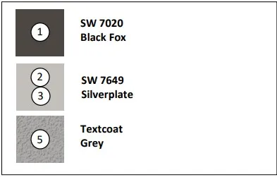
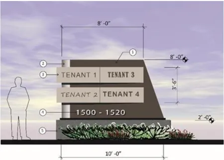
Tenant Monument Sign-Four Tenant
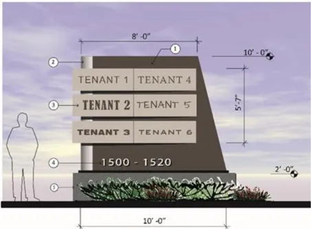
Tenant Monument Sign-Six Tenant
Tenant Monument Sign
Section titled “Tenant Monument Sign”Tenant Monument signs will assist visitors in wayfinding at Metro Air Park and to denote the vehicle entry points to warehouse and distribution facilities or businesses that are not located within a typical large format retail shopping center configuration.
- Tenant Monument Signs will provide street addressing and tenant identification for buildings at major street driveway entries.
- The signage dimensions shall be a maximum of 10 feet in height and 10 feet in width excluding the signage base.
- The maximum area of signage shall be 80 square feet for the area of signage identifying the tenants only
- The dimension of the signage and design shall be consistent with the Tenant Monument Signage depicted and shall indicate the street address number and identify single or multiple tenants, if desired.
- Corporate logos and font styles are allowed in a dark grey color as part of the tenant panels.
- Accent lighting should be concealed behind the text or located flush with grade to be used as signage up-lighting.
- For individual parcels or a group of parcels with one user, one sign is required at the major entry(ies) for each street. The signage shall be positioned perpendicular to, but located outside, the street right-of-way in the landscape easement area. Signage shall be located outside the sight line requirements, as per the County of Sacramento standards.
- See Tenant Monument Signage Materials and Colors.
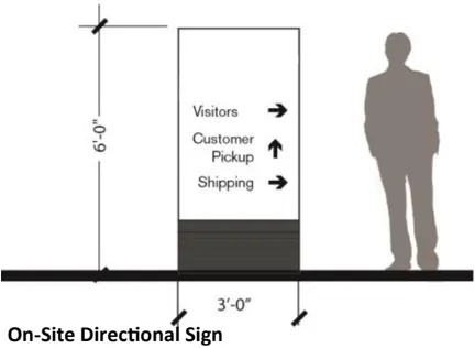
On-Site Directional Sign
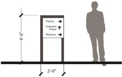
On-Site Directional Sign
Automotive Service Station Fuel Price Monument Signs
Section titled “Automotive Service Station Fuel Price Monument Signs”- There shall be no more than one fuel price sign per automotive service station roadway frontage.
- The automotive service station may also be identified with a separate tenant monument sign, as described above. If there are other businesses on the same parcel as the automobile service station, both the service station and the other businesses shall be identified on the same tenant monument sign.
- The maximum area of the sign shall be 40 square feet.
- Fuel price signs shall be located so that the part of the sign located closest to the street right-of-way line, including supporting structure, shall be
- set back not less than 10 feet (If PUPF easement: 16 feet) from existing public street improvements or right-of-way line.
- The maximum height of the sign at the minimum setback from the street right-of-way shall be 6 feet. The height of the sign may be increased one (1) foot for each foot the setback f the sign is increased, provided, however, that the maximum height of the sign shall not exceed 10 feet in any case.
- Lighting shall be so arranged so as not to produce a glare on other properties in the vicinity and the source of light shall not be visible from adjacent property or public street.
- Corporate logos and font styles are allowed in a dark grey color as part of the tenant identification.
- See Tenant Monument Signage Materials & Color guidelines. Fuel price signs shall follow the style of the Master Sign Program.
On-Site Directional Signs
Section titled “On-Site Directional Signs”- On-site directional signage shall be used to provide directional and wayfinding information.
- The maximum sign face shall be four square feet (4 s.f.). The signage dimensions shall be a maximum of six feet (6’) in height and three feet (3’) in width. The depth is limited to one foot (1’).
- Lighting, if desired, shall be flush with finish grade and be used as signage up-lighting.
Figure 5 - Wall Sign
Section titled “Figure 5 - Wall Sign”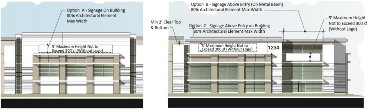
Single Tenant Building Signs
Section titled “Single Tenant Building Signs”It is important that wall signage be proportional to the building scale and mass in order to provide appropriate identification of businesses and building entrances within the project. Typical warehouse square footage, building mass, and building setbacks from the street frontages, will require signage large enough to achieve this goal; see Figure 5 for typical building sign designs; sizes and locations.
Single tenant buildings with office, hotel, research and development, high cube warehouse, and light manufacturing uses, or buildings dominated by one tenant will be allowed the following signage:
- Total sign area allowed on each parcel shall be calculated as the sum of all types of signs shall not exceed one (1) square foot of sign area for each lineal foot of building frontage of business being advertised.
- Wall signage shall not exceed 300 square feet per individual sign, excluding logo design elements and shall be limited to no more than two (2) wall signs per building frontage
- Wall signage shall consist of individually mounted letters and logo elements to be back lit or halo illuminated only.
- At least one main entrance that faces a public street shall have a wall sign above or adjacent to it.
- Maximum wall sign height on commercial retail, hotel and office buildings shall be five feet (5’). Signs on manufacturing, warehouse and research and development buildings shall not be subject to this height limit but shall be proportional to the size of the building on which they are placed.
- Maximum wall sign width including logo shall be 80% of the background building panel width or architectural detailing; see Figures 5 and 6.
- See Figures 5 and 6 for typical building signage locations.
Figure 6 - Typical Wall Sign Locations
Section titled “Figure 6 - Typical Wall Sign Locations”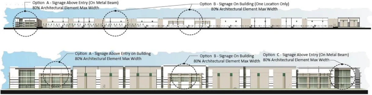
Figure 7 - Landscape Intersection Concept
Section titled “Figure 7 - Landscape Intersection Concept”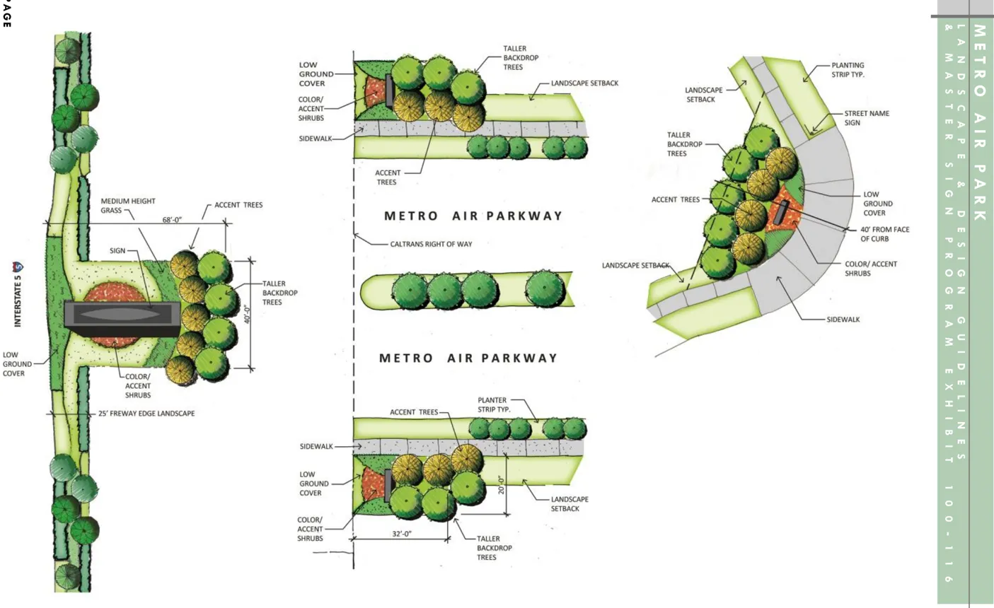
Multi-Tenant Building Signs
Section titled “Multi-Tenant Building Signs”Multi-tenant building signage shall be permitted as allowed per the Sacramento County Zoning Code section 5.10.2.
Building Address Signs
Section titled “Building Address Signs”- Address signage shall be permitted and approved per Building Department, Fire and Sheriff Department requirements.
12.0 STREETSCAPE LANDSCAPE GUIDELINES
Section titled “12.0 STREETSCAPE LANDSCAPE GUIDELINES”Streetscape corridors will serve as a unifying element within Metro Air Park and will contribute to the overall sense of design continuity and character. The overall landscape concept has been designed to reinforce a hierarchy of streets within the project including enhancement of key access points.
All landscape elements that are placed within these corridors shall follow the general landscape requirements set forth in this document and are to be maintained by the Metro Air Park Landscape and Lighting Assessment District.
General Landscape Requirements
Section titled “General Landscape Requirements”- An overall integration of planting between streetscapes and the interior of the development is required. Planting design should focus on plant masses of a single species.
- Planting should provide visual interest through use of color and texture at vehicular and pedestrian entries into the project development.
- The use of drought tolerant trees, shrubs, ornamental grasses and groundcover is recommended. Grading and berming shall be used in conjunction with plant materials to effectively screen parking, loading and storage areas.
- Landscaping at entryways shall maintain adequate sight lines for visual safety, visibility and security per County standards.
- All landscape planting shall be watered by an automated irrigation system in conformance with standards and guidelines.
- Refer to the General Landscape and Irrigation Design Guidelines in Section 13 for additional information and requirements.
Metro Air Park Entrances
Section titled “Metro Air Park Entrances”Five primary entrances or gateways have been identified for special treatment to enhance the sense of arrival into Metro Air Park; see Figure 7. These gateways will feature monument signage with coordinated landscape and hardscape elements to create a unifying, common theme for the plan area. A detailed design of the entry monument signs will be prepared with improvement plans during the first phase of construction. All five entries will receive a similar treatment to create an overall project branding statement. The gateways are located at:
- Interstate 5 and Metro Air Parkway
- Elkhorn Boulevard and Power Line Road. (Signage located on both sides of the street)
- Lone Tree Road and Elkhorn Boulevard
- Elverta Road and Metro Air Parkway
- Elverta Road and Lone Tree Road (signage located on the west side of Lone Tree Road only)
Gateway landscape elements are to be designed utilizing the following criteria:
- The enhanced gateways shall make use of a layered combination of plant materials and seasonal color and texture, flowering accent trees, with evergreen backgrounds. Refer to Appendix A for plant selection information.
- Shrubs, perennials, ornamental grasses, groundcovers, and annuals used in these areas should be planted in formal groupings to make a strong entrance statement. Planting shall be carefully selected to avoid obscuring entry signage.
- Gateway monuments shall incorporate vertical and horizontal elements that identify entry into the project development. The location of each entry monument shall be placed outside of site line requirements as specified by the County of Sacramento.
- Monument signage shall include the Metro Air Park logo and name.
Major Intersection Landscape
Section titled “Major Intersection Landscape”As part of the overall project branding statement, two key intersections along Metro Parkway have been identified for special treatment; see Figure 7. These intersections are:
- Metro Air Parkway and Elkhorn Boulevard
- Metro Air Parkway and Elverta Road
Figure 8 - Road Locations
Section titled “Figure 8 - Road Locations”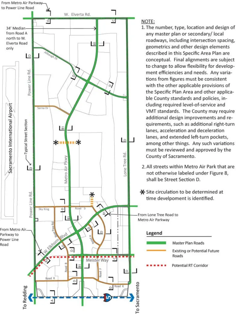
Figure 9 - Street Landscape Trees
Section titled “Figure 9 - Street Landscape Trees”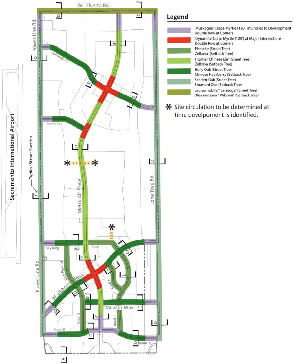
- These major intersections should make use of a layered combination of plant materials with seasonal color, strong evergreen background, and flowering accent features.
- Shrubs, perennials, ornamental grasses, groundcover, annuals should be planted in formal groupings to accent intersection and gateway themes. Refer to the approved plant list in Appendix A.
- The intersections are encouraged to incorporate enhanced lighting to provide night visibility of pedestrians.
Freeway Edge - Section A
Section titled “Freeway Edge - Section A”The landscape themes along the I-5 corridor will enhance the freeway edge and create visual interest; see Figure 9. One theme is more formal consisting of evergreen trees in angled rows inspired by windrows seen in the Central Valley. The second theme is informal tree groupings arranged to allow openings for views into the project. The use of these alternating concepts reflects a contemporary aesthetic. Groupings of shrubs, fescues, and grasses will be planted as understory for trees. The landscaped frontage setback along I-5 will maintain a minimum of twenty-five feet (25’) in width. The image to the left depicts the conceptual design.
- Twenty-five foot (25’) landscape easement north of the Interstate 5 right-of-way has been created to provide a landscape buffer.
- Landscaping is also proposed within the adjacent thirty-three foot (33’) California Department of Transportation (Caltrans) right-of-way to create a landscape corridor over fifty feet (50’) wide.
- Plantings proposed within the Interstate 5 Caltrans right-of-way must conform with the Caltrans guidelines for landscape improvements.
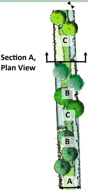
Section A
Section titled “Section A”- Setback: 25' Minimum Landscape Setback (from property line)
- Trees:
Quercus ilex / Holly Oak
- 24’ Box @ 30’ o.c
Quercus coccinea / Scarlet Oak
- 24’ box @ 20’ o.c.
- Understory Planting:
Arbutus unedo ‘Compacta’/ Compact Strawberry Tree
Arctostaphylos ‘Howard McMinn’/ Howard McMinn Manzanita
Arctostaphylos ‘Pacific Mist’/ Pacific Mist Arctostaphylos
Rosmarius officinalis ‘Tuscan Blue’/ Tuscan Blue Rosemary
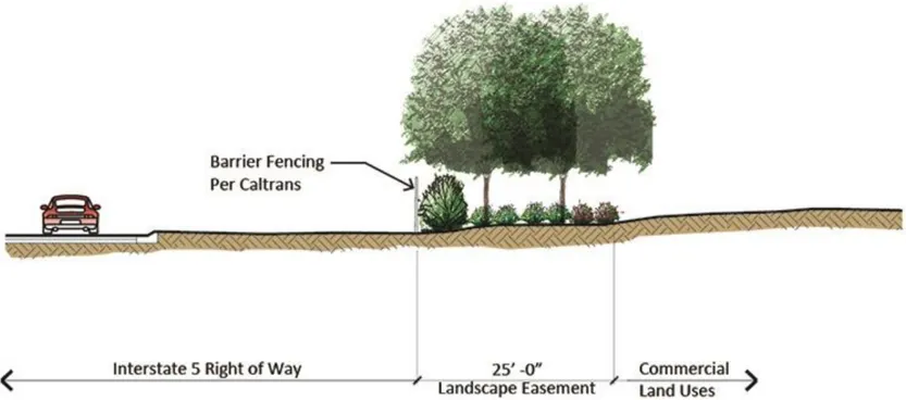
Section A/Private Landscape Setback
- Interstate 5 right-of-way
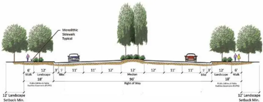
Street Section B1/Private Landscape Setback
- Metro Air Parkway (34’ Median North of Allbaugh Drive to W. Elverta Road)
- W. Elkhorn Blvd from Lone Tree Road to Metro Air Parkway
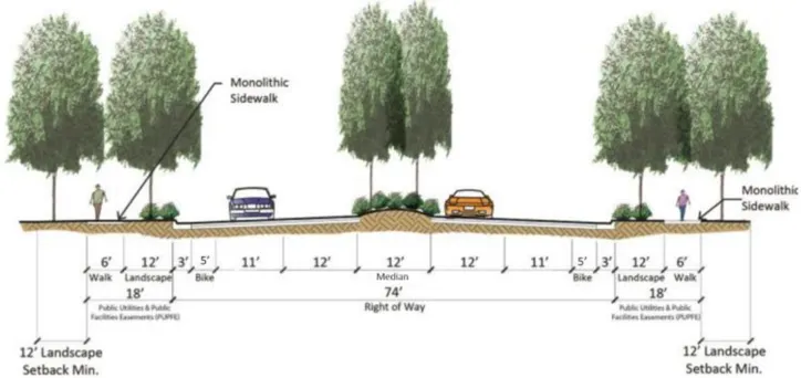 Note: Additional PUPFE may be requested by utility providers as need for utilities.
Street Section B2/Private Landscape Setback
- W. Elkhorn Blvd from Metro Air Parkway to Power Line Road
Street Section B1
Section titled “Street Section B1”Metro Air Parkway consists of a six-lane divided thoroughfare from Elverta Road to Interstate 5; see Figure 8. When developed, it will provide a landscape element that will unify the project through the cohesive use of trees and understory plant materials. The road section as illustrated consists of one twelve foot (12’) lane and two eleven foot (11’) lanes, a five foot (5’) wide bike lane, three foot (3’) wide curb and gutter, a twelve foot (12’) landscape corridor and a six foot (6’) wide monolithic walk adjacent to the landscape corridors per travel direction, and a twelve foot (12’) wide landscape median. The sidewalk shall be set back twelve feet (12’) feet from the face of curb to allow planting, except at intersections and driveways.
-
The median shall be planted with the street tree type indicated in Figure 9 along with accent trees, shrubs, perennials, ornamental grasses and evergreen groundcovers. The landscape easement adjacent to the roadway shall be planted with a double row of large deciduous or evergreen shade trees spaced thirty feet (30’) on-center. This tree spacing shall provide shade for pedestrians and identify Metro Air Parkway as a primary thoroughfare for Metro Air Park.
-
Understory plantings should make use of a layered combination and shall be designed to screen parking areas and headlights from the opposing traffic lanes. Understory plantings shall be used in long continuous “drifts” along the roadway.
-
Monolithic sidewalks shall be located a minimum eight feet (8) from the back of curb.
-
The accent rock surfacing can be generally described as 4’-6’ cobbles that will be placed un-mortared over a weed barrier to help with the control of weeds and pests. The purpose of the rock design concept is to create a varied experience to the streetscape by breaking up the landscape planting with a pattern of ’ swaths ’ of rock. The accent rock shall not exceed 35% of the total landscape area.
-
The accent rock will generally consist of up to 150’ lengths of rock in the medians and planting strips broken up with approximately 150’ of landscaping planting in a pattern that will continue the lengths of the streets and the industrial roads.
-
A similar pattern of generally 150’ lengths of accent rock surfacing alternating with 150’ of landscape planting in a more curvilinear shape will generally occur within the private landscape located at the back of the sidewalk. The accent rock surfacing within the private landscape area will complement the public street landscape and reinforce the design concept and enhance the overall visual character of the streetscape.

Typical 4’-6’ Cobbles
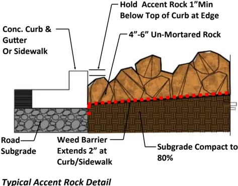
Typical Accent Rock Detail
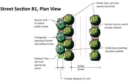
Street Section B1, Plan View
Street Section B1
Section titled “Street Section B1”Street Trees (both sides of streets)
See Figure 9 for Tree Species
24’ Box @ 30’ o.c.
Setback (both sides of streets)
12’ Minimum Landscape Setback (from back of Walk)
Setback Trees (both sides of streets)
See Figure 9 for Tree Species
24’ Box @ 30’ o.c.
Understory Planting:
Ceanothus ‘Concha’/ Concha Ceanothus
Rhus ovata/ No common name
Salvia leucantha ‘Santa Barbara’/ Santa Barbara Sage
Rosmarinus officinalis ‘Collingwood Ingram’/ Prostrate Rosemary
Street Section B2
Section titled “Street Section B2”W. Elkhorn Boulevard consists of a four-lane divided thoroughfare from Metro Air Parkway to Power Line Road; see Figure 8. When developed, it will provide the main east/west circulation with Highway 99 to the east of the project. The road section as illustrated consists of a twelve foot (12’) lane, an eleven foot (11’) lane, a four foot (4’) wide bike lane, a three foot (3’) wide curb and gutter, a twelve foot (12’) landscape corridor and a six foot (6’) wide monolithic walk adjacent to the landscape corridors per travel direction, and a twelve foot (12’) wide landscape median. The sidewalk shall be set back twelve feet (12’) from the face of curb to allow planting, except at intersections and driveways.
- The median shall be planted with the street tree type indicated in Figure 9 along with accent trees, shrubs, perennials, ornamental grasses and evergreen groundcovers. The landscape easement adjacent to the roadway shall be planted with a double row of large deciduous or evergreen shade trees spaced thirty feet (30’) on-center. This tree spacing shall provide shade for pedestrians. Understory plantings should make use of a layered combination and shall be designed to screen parking areas and headlights from the opposing traffic lanes. Understory plantings shall be used in long continuous “drifts” along the roadway.
- Monolithic sidewalks shall be located a minimum of eight feet (8’) from the back of curb.
- The accent rock surfacing can be generally described as 4’-6’ cobbles that will be placed un-mortared over a weed barrier to help with the control of weeds and pests. The purpose of the rock design concept is to create a varied experience to the streetscape by breaking up the landscape planting with a pattern of ’ swaths ’ of rock. The accent rock shall not exceed 35% of the total landscape area.
- The accent rock will generally consist of up to 150’ lengths of rock in the medians and planting strips broken up with approximately 150’ of landscaping planting in a pattern that will continue along the lengths of the streets and the industrial roads.
- A similar pattern of generally 150’ lengths of accent rock surfacing alternating with 150’ of landscape planting in a more curvilinear shape will generally occur within the private landscape located at the back of the sidewalk. The accent rock surfacing within the private landscape area will complement the public street landscape and reinforce the design concept and enhance the overall visual character of the streetscape.
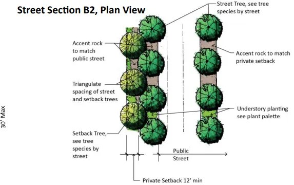
Street Section B2, Plan View
Street Section B2
Section titled “Street Section B2”Street Trees (both sides of streets)
See Figure 9 for Tree Species
24’ Box @ 30’ o.c.
Setback (both sides of streets)
12’ Minimum Landscape Setback (from back of Walk)
Setback Trees (both sides of streets)
See Figure 9 for Tree Species
24’ Box @ 30’ o.c.
Understory Planting:
Ceanothus ‘Concha’/ Concha Ceanothus
Rhus ovata/ No common name
Salvia leucantha ‘Santa Barbara’/ Santa Barbara Sage
Rosmarinus officinalis ‘Collingwood Ingram’/ Prostrate Rosemary
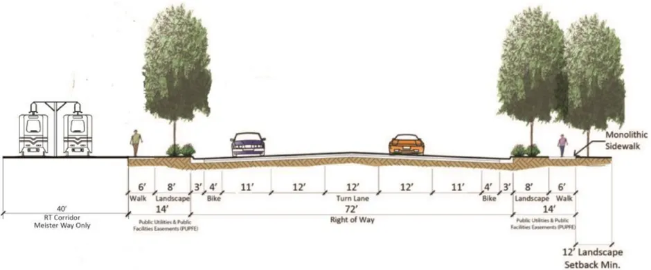
Note: Additional PUPFE may be requested by utility providers as need for utilities. Street Section C/Private Landscape Setback
- Meister Way from Lone Tree Road to Metro Air Pkwy
- Elverta Road from Lone Tree Road to Metro Air Pkwy (Landscape South side Only)
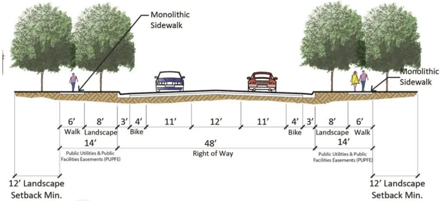
Note: Additional PUPFE may be requested by utility providers as need for utilities. Street Section D/Private Landscape Setback
- Allbaugh Drive from Lone Tree Road to Power Line Road
- Lone Tree Road from W. Elverta Road to Bayou Way (Landscape West Side Only)
- Power Line Road from Elkorn Blvd to Elverta Road (Landscape East Side Only)
- Elverta Road from Metro Air Pkwy to Power Line Road (Landscape South Side Only)
- Other Secondary Roads
Street Section C
Section titled “Street Section C”Meister Way and W. Elverta Road street sections shall consist of a maximum of four travel lanes and one turn lane from Lone Tree Road to Metro Air Parkway; see Figure 8. The road section as illustrated consists of a twelve foot (12’) lane, an eleven foot (11’) lane, five foot (5’) wide bike lane, a three foot (3’) curb and gutter, an eight foot (8’) wide landscape area and a six foot (6’) wide monolithic walkway per travel direction, and a twelve foot (12’) wide center dual turn lane.
- The landscape easement adjacent to the roadway shall be planted with a double row of large deciduous or evergreen shade trees spaced thirty feet (30’) on-center to provide shade for pedestrians.
- Understory planting should make use of a layered combination of heights, accents, screening effects, consisting of both deciduous and evergreen species. Shrub massings should be planted throughout this corridor.
- Monolithic sidewalks shall be located a minimum eight feet (8) from the back of curb.
- The accent rock surfacing can be generally described as 4’-6 cobbles that will be placed un-mortared over a weed barrier to help with the control of weeds and pests. The purpose of the rock design concept is to create a varied experience to the streetscape by breaking up the landscape planting with a pattern of ’ swaths ’ of rock. The accent rock shall not exceed 35% of the total landscape area.
- The accent rock will generally consist of up to 150’ lengths of rock in the medians and planting strips broken up with approximately 150’ of landscaping planting in a pattern that will continue along the lengths of the streets and the industrial roads.
- A similar pattern of generally 150’ lengths of accent rock surfacing alternating with 150’ of landscape planting in a more curvilinear shape will generally occur within the private landscape located at the back of the sidewalk. The accent rock surfacing within the private landscape area will complement the public street landscape and reinforce the design concept and enhance the overall visual character of the streetscape.
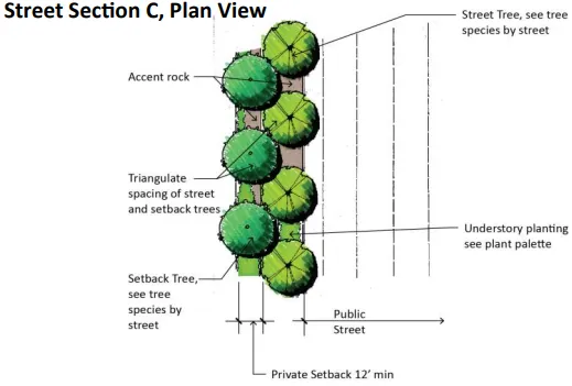
Street Section C, Plan View
Street Section C
Section titled “Street Section C”Street Trees:
See Figure 9 for Tree Species
24’ Box @ 30’ o.c.
Setback:
12’ Minimum Landscape Setback (from back of Walk)
Setback Trees:
See Figure 9 for Tree Species
24’ Box @ 30’ o.c.
Understory Planting:
Ceanothus ‘Concha’/ Concha Ceanothus Rhus ovata/ No common name
Salvia leucantha ‘Santa Barbara’/ Santa Barbara Sage
Rosmarinus officinalis ‘Collingwood Ingram’/ Prostrate Rosemary
Street Section D
Section titled “Street Section D”Street Trees:
See Figure 9 for Tree Species
24’ Box @ 30’ o.c.
Setback:
12’ Minimum Landscape Setback (from back of Walk)
Setback Trees:
See Figure 9 for Tree Species
24’ Box @30’ o.c.
Understory Planting:
Ceanothus ‘Concha’/ Concha Ceanothus Rhus ovata/ No common name
Salvia leucantha ‘Santa Barbara’/ Santa Barbara Sage
Rosmarinus officinalis ‘Collingwood Ingram’/ Prostrate Rosemary
Interior Streets - Street Section D
Section titled “Interior Streets - Street Section D”Sections of W. Elverta Road, Lone Tree Road, Power Line Road , Allbaugh Drive, and other proposed secondary streets. The road section as illustrated consists of an eleven foot (11’) , a five foot (5’) bike lane, a three foot (3’) curb and gutter, an eight foot (8’) landscape area, and a six foot (6’) wide monolithic walkway per travel direction, and a twelve foot (12’) wide center dual turn lane.
- A double row of large shade trees shall be planted on the side(s) of the road indicated on page 43. The trees shall be spaced thirty feet (30’) on-center to provide shade for pedestrians. The tree planting shall identify these corridors as secondary roadways and have incorporated into its plan consideration for industrial delivery truck heights.
- Understory planting should make use of a layered combination of heights, accents and evergreen screening effects. Shrub massing shall be planted throughout this section of roadway.
- Monolithic sidewalks shall be located a minimum of eight feet (8) from the back of curb.
- The accent rock surfacing can be generally described as 4’-6’ cobbles that will be placed un-mortared over a weed barrier to help with the control of weeds and pests. The purpose of the rock design concept is to create a varied experience to the streetscape by breaking up the landscape planting with a pattern of ’ swaths ’ of rock. The accent rock shall not exceed 35% of the total landscape area.
- The accent rock will generally consist of up to 150’ lengths of rock in the medians and planting strips broken up with approximately 150’ of landscaping planting in a pattern that will continue along the lengths of the streets and the industrial roads.
- A similar pattern of generally 150’ lengths of accent rock surfacing alternating with 150’ of landscape planting in a more curvilinear shape will generally occur within the private landscape located at the back of the sidewalk. The accent rock surfacing within the private landscape area will complement the public street landscape and reinforce the design concept and enhance the overall visual character of the streetscape.
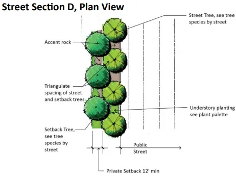
Street Section D, Plan View
Public Transportation Facilities
Section titled “Public Transportation Facilities”Metro Air Park was designed to accommodate light rail and bus service to the development. A light rail line is proposed to enter the site from Meister Way and proceed to Elkhorn Boulevard where it will follow this corridor in a southwestern direction. Bus stop facilities shall be located as development occurs. For additional information, refer to the Sacramento Regional Transit District’s (SacRT’s) Design Guidelines for Buses and Light Rail Facilities.
Bus Stop Design Guidelines
Section titled “Bus Stop Design Guidelines”A bus stop is a curbside area specifically designated for passenger loading and unloading. It is commonly identified by a bus stop sign, a red curb marking, and where demand merits, benches and/ or shelters. The different types of bus stops and specific considerations under which they are recommended are described below:
- Farside Stops: Farside stops are located beyond street intersections. Farside stops shall be used wherever practical.
- Mid-block Stops: Mid-block stops are located between roadway intersections. Mid-block stops must be accompanied by a pedestrian crosswalk.
- Near-side Stops: Near-side stops are located immediately preceding street intersections. Near-side stops, while not recommended, may be considered where little distance exists between signalized intersections or where curb side parking is permitted.
- Recommended Spacing-a quarter-mile or 1,320 feet apart maximum.
- Intermediate placement distances may be considered on a case-by-case basis depending on the density of the market area served.
- Bus Stop Curbs: Curbs at bus stops shall be 6 inches high to facilitate passenger boarding and unloading. If the curb is too high, it will interfere with the operation of the wheelchair lift and front kneel feature of new buses.
- Bus stop curbs shall be painted red and signs stating “no parking” or “no stopping except for buses” shall be positioned so as to clearly identify the bus stop areas.
- A striped, white 8-inch line will be used to indicate and separate the bus stop from adjacent traffic lanes. The pavement shall be stenciled “Bus Stop.”
- Bus stops/shelters should be designed using the overall Metro Air Park concept and made of durable materials providing shelter from rain, sun and wind. These shelters shall have seating and be visible inside to aid in public security. Refer to SacRT’s Design Guidelines for Bus and Light Rail Facilities more information.
Light Rail Design Guidelines
Section titled “Light Rail Design Guidelines”The dimensions noted below represent the preferred minimums to accommodate light rail. The dimensions presume that future light rail systems will be double tracked
- For Track Only : Preferred minimum clearance envelope-forty feet (40’) wide fifty feet (50’) wide where no adjacent roadways exist) by twenty-five feet (25’) high.
- For Truck and Station : Preferred minimum clearance envelope-sixty feet (60’) wide by twenty-five feet (25’) high.
- In situations where the preferred clearance envelope cannot be accommodated, reduced dimensions may be allowed on a case-by-case basis subject to review and approval by SacRT.
- The right-of-way width must encompass all necessary facilities.
- A major public art piece shall be included within the Light Rail Station/Plaza.
- Public Art will enhance the Light Rail Station/Plaza as an integral component of its design.
- Light rail stops/shelters shall be designed using the overall Metro Air Park concept and made of durable materials providing shelter from rain, sun and wind. These shelters shall have seating and be visible inside to aid in public security.
Street Furniture
Section titled “Street Furniture”Bollards, benches, trash receptacles and decorative pots shall be considered as hardscape elements. These hardscape elements should reflect the Metro Air Park campus setting and overall site characteristic of each district. All material used for such hardscape elements shall accent and highlight each district’s architecture.
- The following materials are acceptable for use as hardscape elements:
- Painted metal
- Brick or stone
- Concrete
- Wood
- Benches should complement architectural, lighting and community themes throughout Metro Air Park.
- Site-specific hardscape elements and details should relate to the theme and character of the development.
- A maximum of three (3) periodical and pick-up overnight delivery stands, vending and newspaper machines should be allowed per district.
- Street furniture should be kept clean and in working function. The Metro Air Park Lighting and Assessment District or other appropriate maintenance entity shall notify the manufacturer if vandalism and/or malfunctions occur.
- The spacing between street furniture shall be a maximum of fifteen hundred feet (1,500’) per each district.
- Seat walls should be designed with materials that complement and accent architectural themes.
- Drinking fountains should be constructed of durable materials and finished with vandal-resistant products.
- Picnic tables or elements on which persons will eat shall be constructed of durable materials that complement architecture themes.
- All street furniture, at a minimum, shall meet all applicable governing codes and standards regarding safety and accessibility for the public. Street furniture shall consist of vandal-resistant products.
- A list of all materials, finishes, and locations shall be given to the Metro Air Park Lighting and Assessment District or other appropriate maintenance entity.
- Decorative pots shall accent the core theme and complement adjacent street furnishings. All decorative pots when used in conjunction with vegetation shall be installed with an automatic irrigation system and have adequate drainage so as not to stain adjacent paving or furnishings.
13.0. GENERAL LANDSCAPE AND IRRIGATION GUIDELINES
Section titled “13.0. GENERAL LANDSCAPE AND IRRIGATION GUIDELINES”Developments within Metro Air Park are allowed flexibility within the parameters of these guidelines. However, incorporating consistent landscape elements will unify and strengthen the overall design concept for The need for a is most critical at public rights-of-way and less critical within individual development projects.
General Requirements
Section titled “General Requirements”- Projects are required to meet the requirements of the County Water Efficient Landscape Ordinance (WELO).
- 24’ box container size shall be the minimum tree size allowed. Larger tree containers such as 36“ box are recommended at key focal points to more quickly provide an established appearance.
- Incorporate a hydro zoned planting scheme to reduce water demand by grouping plants with similar water requirements.
- Tree plantings shall not interfere with night illumination, site line visibility at driveways or intersections, or be located within minimum clearance zones of service utilities.
- Understory planting adjacent to public rights-of-way and landscape easements shall blend with existing plantings and shall be used to screen parking courts, utility services, loading and unloading areas.
- Landscape plans shall be submitted and prepared separately for private developments and those areas in the maintenance district.
Water Conservation
Section titled “Water Conservation”Metro Air Park is committed to providing landscape design that exceeds ordinary standards and basic vegetation palettes. Construction and improvements that occur within the development shall implement water-conserving planting species and shall be consistent with Sacramento County requirements .
- Turf grass is highly discouraged within Metro Air Park due to the high-water use and maintenance costs. If turf grass is used, a drought tolerant Fescue blend shall be used and should not exceed 5% of the total landscape area. Activities that are part of recreational amenities shall be exempt from the turf grass limitation.
- The selection of a plant palette should take into consideration the use of California native, drought and fire tolerant plant species and materials.
Irrigation Design
Section titled “Irrigation Design”- Irrigation systems that provide water efficiency and conservation are required.
- Automatically-controlled irrigation systems shall be used.
- Landscape areas shall be individually valved in relation to each respective hydro zone. Hydro zones shall consider solar orientation, exposure, slope and soil conditions.
- The installation of all backflow preventers shall comply with all applicable County/State codes and standards. All backflow preventers shall be in shrub areas and screened from public view, to the extent possible.
- All turf grass areas must be irrigated with pop-up spray or rotary impact heads. A minimum riser of six inches (6“) shall be used for all spray and rotor heads.
- Sprinkler spacing should ensure head-to-head coverage.
- Low water use irrigation, spray heads, and rotors are required. Micro-irrigation equipment, moisture sensing devices and/or pressure regulating bubblers are recommended.
- Irrigation systems within public rights-of-way shall operate independently from private projects.
14.0 LANDSCAPE MAINTENANCE GUIDELINES
Section titled “14.0 LANDSCAPE MAINTENANCE GUIDELINES”To ensure long-term success and overall attractive appearance of landscapes on private developments within Metro Air Park, owners are required to perform regular maintenance in conformance with these standards. Proper horticultural and irrigation practices should be used with care and regularity. All maintenance shall be performed by experienced landscape maintenance professionals who are familiar with the specific requirements and growth habits of plant materials in the area.
General Guidelines
Section titled “General Guidelines”- Plant materials shall be maintained in a healthy growth condition and kept in a neat, attractive appearance throughout the year.
- Plant materials shall be allowed to grow into their natural shape and size, without the need for persistent and excessive pruning or hedging.
- Hardscape and softscape elements should maintain the function and integrity of the original design intent.
- Plant establishment periods, under the installation contract and in project specifications, are required for all landscape installations to be a minimum of ninety (90) days.
Regularly Performed Maintenance
Section titled “Regularly Performed Maintenance”Turf Requirement
Section titled “Turf Requirement”- Mowing and edging of all turf grass areas should be accomplished every seven (7) days during the growing season and on an as needed basis during fall and winter. All clippings shall be disposed of in a legal manner.
- Edging should be accomplished by mechanical means only.
- Turf grass areas should be irrigated according to water schedules programmed by the site landscape maintenance contractor.
- Lawn areas should be aerated and fertilized regularly per the recommendations of the turf grass manufacturer.
Annual Bed Maintenance
Section titled “Annual Bed Maintenance”- Annual color beds shall be replanted a minimum of four times per year with seasonally available varieties.
- Soil in annual bed planting areas shall be thoroughly prepared prior to each planting, including the addition of fertilizers. Soil amendments such as greenwaste compost shall be incorporated to improve soil conditions on a regular basis.
Groundcover Maintenance
Section titled “Groundcover Maintenance”- Groundcovers should be maintained to create an attractive, uniform ground plane.
- Weeds shall be controlled by means of pre-emergent herbicides as well as experienced hand labor. Weeds shall be removed on an as needed basis from groundcover areas.
Tree Maintenance
Section titled “Tree Maintenance”- Tree canopies shall be pruned, tipped or pinched to retain as much foliage as possible and to promote long term tree shape and canopy structure. High or low branches shall be removed only if they pose a danger to public safety. The branches are to be cut flush with the trunk. Tree roots shall be pruned to remove stem girdling and/or root circling or other defects which may result in producing an unstable or unhealthy tree.
- Evergreen trees should be thinned and shaped as necessary to prevent hazardous conditions, and to minimize wind and storm drainage. Primary pruning shall be executed during the dormant season.
- Tree staking ties shall be monitored bi-annually for alignment, anchoring, or adjustment.
- Tree stakes should be removed after the third or fourth year or as recommended by a Certified Arborist.
- All trees in turf grass areas shall have a thirty-six inch (36’) diameter circle of unplanted, mulched soil maintained at their bases at all times to minimize damage by trimmers and mowers.
Pruning
Section titled “Pruning”- Trees and shrubs should be pruned to maintain a natural appearance by selecting permanent scaffold branches or to conform to the designer’s intent.
- Maintaining the natural form and habitat of each plant species. Do not pollard, topiary or hedge plants into geometric configurations.
- Monitor for diseased or unsound branching and/or sucker growth on all trees and remove immediately.
Appendix A Recommended Plant List
Section titled “Appendix A Recommended Plant List”This table has been split into multiple tables to comply with accessibility requirements. The following seven tables shall all be referred to as a part of Appendix A Recommended Plant List
Trees Evergreen
Section titled “Trees Evergreen”| Plant Name | Foreground | Background | Accent | Street Median Trees (Fig. 9) | Street Trees Special (Fig. 9) | Parking Lot Shading | Entry Highlight | Intersection Highlight | Drought Tolerant | Riparian Corridor | Power Line Tree | Setback Trees See Figure 9 |
|---|---|---|---|---|---|---|---|---|---|---|---|---|
| Cedrus deodara / Deodar Cedar | ✓ | ✓ | ||||||||||
| Cinnamomum camphora / Camphor Tree | ✓ | ✓ | ||||||||||
| Arbutus × ‘Marina’ / Marina Arbutus | ✓ | ✓ | ✓ | ✓ | ✓ | ✓ | ||||||
| Eriobotrya deflexa / Bronze Loquat | ✓ | ✓ | ✓ | ✓ | ✓ | ✓ | ✓ | |||||
| Laurus nobilis ‘Saratoga’ / Saratoga Sweet Bay | ✓ | ✓ | ✓ | ✓ | ||||||||
| Magnolia grandiflora / Southern Magnolia | ✓ | ✓ | ||||||||||
| Olea europaea ‘Wilsonii’ / Wilson’s Olive | ✓ | ✓ | ✓ | ✓ | ||||||||
| Pinus halepensis / Calabrian Pine | ✓ | ✓ | ||||||||||
| Pinus eldarica / Afghan Pine | ✓ | ✓ | ||||||||||
| Quercus ilex / Holly Oak | ✓ | ✓ | ||||||||||
| Quercus wislizeni / Interior Live Oak | ✓ | ✓ | ✓ |
Trees Deciduous
Section titled “Trees Deciduous”| Plant Name | Foreground | Background | Accent | Street Median Trees (Fig. 9) | Street Trees Special (Fig. 9) | Parking Lot Shading | Entry Highlight | Intersection Highlight | Drought Tolerant | Riparian Corridor | Power Line Tree | Setback Trees See Figure 9 |
|---|---|---|---|---|---|---|---|---|---|---|---|---|
| Aesculus californica / California Buckeye | ✓ | ✓ | ||||||||||
| Betula nigra ‘Dura Heat’ / Dura Heat River Birch | ✓ | ✓ | ||||||||||
| Cercis occidentalis ‘Forest Pansy’ / Forest Pansy Chinese Redbud | ✓ | ✓ | ✓ | ✓ | ✓ | ✓ | ✓ | |||||
| Gleditsia triacanthos ‘Skyline’ / Skyline Honey Locust | ✓ | ✓ | ✓ | |||||||||
| Acer rubrum ‘Redpointe’ / Redpointe Maple | ✓ | ✓ | ✓ | |||||||||
| Carpinus betulus ‘Emerald Avenue’ / Emerald Avenue Hornbeam | ✓ | ✓ | ✓ | ✓ | ||||||||
| Celtis sinensis / Chinese Hackberry | ✓ | |||||||||||
| Ginkgo biloba ‘Saratoga’ / Saratoga Maidenhair Tree | ✓ | ✓ | ✓ | ✓ | ✓ | ✓ | ✓ | |||||
| Platanus x acerifolia ‘Columbia’ / Columbia London Plane Tree | ✓ | ✓ | ✓ | ✓ | ||||||||
| Koelreuteria paniculata / Golden Rain Tree | ✓ | ✓ | ✓ | ✓ | ||||||||
| Quercus rubra / Red Oak | ✓ | ✓ | ✓ | ✓ | ✓ | |||||||
| Lagerstroemia hyb. ‘Muskogee’ / Lavender Flowering Crape Myrtle | ✓ | ✓ | ✓ | ✓ | ||||||||
| Lagerstroemia hyb. ‘Dynamite’ / Red Flowering Crape Myrtle | ✓ | ✓ | ✓ | ✓ | ✓ | |||||||
| Liriodendron tulipifera / Tulip Tree | ✓ | ✓ | ✓ | |||||||||
| Malus ‘Prairifire’ / Prairifire Crabapple | ✓ | ✓ | ✓ | ✓ | ||||||||
| Pistacia chinensis ‘Keith Davey’ / Keith Davey Chinese Pistache | ✓ | ✓ | ✓ | ✓ | ||||||||
| Platanus racemosa / California Sycamore | ✓ | ✓ | ||||||||||
| Triadica sebifera / Chinese Tallow Tree | ✓ | ✓ | ||||||||||
| Tilia cordata ‘Greenspire’ / Greenspire Little Leaf Linden | ✓ | ✓ | ✓ | |||||||||
| Quercus coccinea / Scarlet Oak | ✓ | ✓ | ✓ | |||||||||
| Quercus shumardii / Shumard Red Oak | ✓ | ✓ | ✓ | |||||||||
| Quercus frainetto ‘Forest Green’ / Forest Green Italian Oak | ✓ | ✓ | ✓ | |||||||||
| Ulmus parvifolia ‘Frontier’ / Frontier Chinese Elm | ✓ | ✓ | ✓ | ✓ | ||||||||
| Zelkova serrata ‘Village Green’ / Village Green Zelkova |
Shrubs
Section titled “Shrubs”| Plant Name | Foreground | Background | Accent | Street Median Trees | Street Trees | Parking Lot Shading | Entry Highlight | Intersection Highlight | Drought Tolerant | Riparian Corridor |
|---|---|---|---|---|---|---|---|---|---|---|
| Anigozanthos ‘Bush Gold’ / Yellow Kangaroo Paw | ✓ | ✓ | ✓ | ✓ | ||||||
| Agapanthus ‘Tinkerbell’ / Tinkerbell Agapanthus | ✓ | ✓ | ✓ | |||||||
| Arbutus unedo ‘Compacta’ / Compact Strawberry Tree | ✓ | ✓ | ||||||||
| Arctostaphylos ‘Sunset’ / Sunset Manzanita | ✓ | ✓ | ||||||||
| Arctostaphylos ‘Howard McMinn’ / Howard McMinn Manzanita | ✓ | ✓ | ||||||||
| Ceanothus ‘Concha’ / Concha Ceanothus | ✓ | ✓ | ||||||||
| Ceanothus ‘Julia Phelps’ / Julia Phelps Ceanothus | ✓ | ✓ | ||||||||
| Salix lasiolepis / Arroyo Willow | ✓ | |||||||||
| Cercis occidentalis / Western Redbud | ✓ | ✓ | ||||||||
| Cistus × purpureus / Orchid Rockrose | ✓ | ✓ | ||||||||
| Dodonaea viscosa / Hopseed Bush | ✓ | ✓ | ||||||||
| Cornus sericea / Redtwig Dogwood | ✓ | |||||||||
| Dietes vegeta / Fortnight Lily | ✓ | ✓ | ✓ | ✓ | ✓ | ✓ | ||||
| Eleagnus pungens / Silverberry | ✓ | ✓ | ||||||||
| Grevillea ‘Scarlet Sprite’ / Scarlet Sprite Grevillea | ✓ | ✓ | ✓ | |||||||
| Heteromeles arbutifolia | ✓ | ✓ | ||||||||
| Lavatera × clementii ‘Lavender Lady’ / Lavender Lady Tree Mallow | ✓ | ✓ | ✓ | ✓ | ||||||
| Pittosporum eugenioides / Lemonwood | ✓ | ✓ | ||||||||
| Salix scouleriana / Upland Willow | ✓ | |||||||||
| Rhus ovata / NCN | ✓ | |||||||||
| Rhaphiolepis indica ‘Dancer’ / Dancer Indian Hawthorn | ✓ | ✓ | ✓ | ✓ | ✓ | |||||
| Rosa californica / California Wild Rose | ✓ | ✓ | ||||||||
| Rosmarinus officinalis ‘Tuscan Blue’ / Tuscan Blue Rosemary | ✓ | ✓ | ✓ | ✓ | ||||||
| Salvia leucantha ‘Santa Barbara’ / Santa Barbara Sage | ✓ | ✓ | ✓ | ✓ | ✓ | ✓ | ✓ | |||
| Achillea millefolium / Common Yarrow | ✓ | ✓ | ✓ | ✓ | ✓ | ✓ | ||||
| Rosa ‘Meidrifora’ / Coral Drift Rose | ✓ | ✓ | ✓ | ✓ | ✓ | ✓ | ||||
| Rosa ‘Meigalpio’ / Red Drift Rose | ✓ | ✓ | ✓ | ✓ | ✓ | |||||
| Lavandula stoechas ‘Otto Quast’ / Otto Quast Spanish Lavender | ✓ | ✓ | ✓ | ✓ | ✓ | ✓ | ✓ | |||
| Punica granatum ‘Chico’ / Chico (Dwarf) Pomegranate | ✓ | ✓ | ✓ | ✓ | ✓ | |||||
| Salvia leucantha ‘Midnight’ / Purple Mexican Sage | ✓ | ✓ | ✓ | ✓ | ✓ | ✓ | ✓ | |||
| Salvia ‘Waverly’ / Waverly Sage | ✓ | ✓ | ||||||||
| Salvia microphylla ‘Hot Lips’ / Hot Lips Sage | ✓ | ✓ | ✓ | ✓ | ✓ | ✓ | ✓ | |||
| Cuphea llavea ‘Batface’ / Batface Cuphea | ✓ | ✓ | ✓ | ✓ | ✓ | ✓ | ✓ |
Groundcover
Section titled “Groundcover”| Plant Name | Foreground | Background | Accent | Street Median Trees | Street Trees | Parking Lot Shading | Entry Highlight | Intersection Highlight | Drought Tolerant | Riparian Corridor |
|---|---|---|---|---|---|---|---|---|---|---|
| Acacia redolens ‘Low Boy’ / Prostrate Acacia | ✓ | ✓ | ||||||||
| Arctostaphylos ‘Emerald Carpet’ / Emerald Carpet Manzanita | ✓ | ✓ | ✓ | ✓ | ✓ | |||||
| Arctostaphylos ‘Pacific Mist’ / Pacific Mist Manzanita | ✓ | ✓ | ✓ | ✓ | ||||||
| Baccharis pilularis ‘Twin Peaks’ / Twin Peaks Coyote Brush | ✓ | ✓ | ✓ | ✓ | ||||||
| Ceanothus g.h. ‘Yankee Point’ / Yankee Point Ceanothus | ✓ | ✓ | ✓ | ✓ | ||||||
| Cotoneaster dammeri ‘Lowfast’ / Lowfast Cotoneaster | ✓ | ✓ | ✓ | ✓ | ✓ | ✓ | ||||
| Helianthemum nummularium / Sunrose | ✓ | ✓ | ✓ | |||||||
| Lantana hyb. ‘Tangerine’ / Tangerine Lantana | ✓ | ✓ | ✓ | ✓ | ||||||
| Myoporum parvifolium ‘Putah Creek’ / Putah Creek Prostrate Myoporum | ✓ | ✓ | ✓ | |||||||
| Rosmarinus officinalis ‘Collingwood Ingram’ / Prostrate Rosemary | ✓ | ✓ | ✓ | ✓ | ✓ | ✓ | ||||
| Trachelospermum jasminoides / Star Jasmine | ✓ | ✓ | ✓ | |||||||
| Turfgrass | ✓ |
| Plant Name | Foreground | Background | Accent | Street Median Trees | Street Trees | Parking Lot Shading | Entry Highlight | Intersection Highlight | Drought Tolerant | Riparian Corridor |
|---|---|---|---|---|---|---|---|---|---|---|
| Ficus pumila / Creeping fig | ✓ | ✓ | ||||||||
| Campsis radicans / Trumpet vine | ✓ | ✓ | ✓ | |||||||
| Parthenocissus tricuspidata / Boston ivy | ✓ | ✓ | ||||||||
| Jasminum polyanthum / Evergreen Jasmine Vine | ✓ | ✓ |
Ornamental Grass
Section titled “Ornamental Grass”| Plant Name | Foreground | Background | Accent | Street Median Trees | Street Trees | Parking Lot Shading | Entry Highlight | Intersection Highlight | Drought Tolerant | Riparian Corridor |
|---|---|---|---|---|---|---|---|---|---|---|
| Carex praegracilis / Field Sedge | ✓ | |||||||||
| Carex tumulicola / Foothill Sedge | ✓ | ✓ | ||||||||
| Chondropetalum tectorum / Cape Rush | ✓ | ✓ | ||||||||
| Deschampsia cespitosa / Tufted Hairgrass | ✓ | ✓ | ||||||||
| Festuca mairei / Atlas Fescue | ✓ | ✓ | ✓ | ✓ | ✓ | ✓ | ✓ | |||
| Juncus patens ‘Elk Blue’ / Elk Blue Rush | ✓ | ✓ | ||||||||
| Lomandra longifolia ‘Breeze’ / Breeze Mat Rush | ✓ | ✓ | ✓ | ✓ | ✓ | ✓ | ✓ | |||
| Panicum virgatum / Switchgrass | ✓ | ✓ | ✓ | ✓ | ||||||
| Stipa pulchra / Purple Needle Grass | ✓ | ✓ | ||||||||
| Muhlenbergia rigens / Deer Grass | ✓ | ✓ | ✓ | |||||||
| Muhlenbergia capillaris ‘Regal Mist’ / Regal Mist Pink Muhly | ✓ | ✓ | ✓ | ✓ | ✓ | ✓ | ✓ | |||
| Pennisetum orientale / Oriental Fountain Grass | ✓ | ✓ | ✓ | ✓ | ✓ | ✓ | ✓ | |||
| Pennisetum alopecuroides ‘Hameln’ / Hameln Fountain Grass | ✓ | ✓ | ✓ | ✓ | ✓ | ✓ | ✓ |
Succulents
Section titled “Succulents”| Plant Name | Foreground | Background | Accent | Street Median Trees | Street Trees | Parking Lot Shading | Entry Highlight | Intersection Highlight | Drought Tolerant | Riparian Corridor |
|---|---|---|---|---|---|---|---|---|---|---|
| Aloe striata / Coral Aloe | ✓ | ✓ | ✓ | ✓ | ✓ | ✓ | ||||
| Aloe ‘Green Pagoda’ / Green Pagoda Aloe | ✓ | ✓ | ✓ | ✓ | ✓ | |||||
| Agave ‘Blue Glow’ / Blue Glow Agave | ||||||||||
| Bulbine frutescens ‘Tiny Tangerine’ / Tiny Tangerine Bulbine | ✓ | ✓ | ✓ | ✓ | ✓ | ✓ | ||||
| Agave ‘Quasimoto Streaker’ / White Cornelius Agave | ✓ | ✓ | ✓ | ✓ | ✓ | ✓ | ||||
| Hesperaloe Parviflora ‘Perpa’ Brakelights / Crimson Yucca | ✓ | ✓ | ✓ | ✓ | ✓ | ✓ | ✓ | |||
| Hesperaloe Parviflora ‘Perpa’ / Desert Flamenco Yucca | ✓ | ✓ | ✓ | ✓ | ✓ | ✓ | ✓ | |||
| Aloe ‘Always Red’ / Always Red Hybrid Aloe | ✓ | ✓ | ✓ | ✓ | ✓ | ✓ | ✓ |
METRO AIR PARK TRANSPORTATION SYSTEMS MANAGEMENT PLAN (TSMP)
Section titled “METRO AIR PARK TRANSPORTATION SYSTEMS MANAGEMENT PLAN (TSMP)”Final Addendum
Section titled “Final Addendum”
December 10, 2020 (edited November 8, 2021; updated March 22, and May 3, 2022, updated June 14, 2022)
Prepared by Transportation Demand Management (TDM) Specialists

Introduction
Section titled “Introduction”Approved in the March 1993 Metro Air Park Final EIR was the Transportation Systems Management Plan (TSMP).
The TSMP identified park-wide vehicle trip mitigation and reduction strategies. TSMP measures complement the 1993 Special Plan Area (SPA) document, 2019 SPA amendment, and County Trip Reduction code requirements.
This updated TSMP addendum complies with current County of Sacramento trip reduction goals. This document is also a companion to the approved 2020 updated Air Quality Management Plan (AQMP) addendum.
The TSMP provides a big-picture scope to reduce vehicle trips and identity expectations to achieve a minimum 1.5 persons per vehicle peak-period travel rate.
The intended use of the TSMP is to guide tenants, employers, and owners in implementing ridesharing and commuter programs. Property owners, tenants, and employers receive Commuter Concierge amenities services to support their commuter program efforts. Tenant/employers provide employee benefits and resources, incentivizing commuter engagement. Attached is a TSMP Action Summary, which identifies Metro Air Park’s TSM requirements, commuter programs and services, and tenant/employer-required programs and benefits.
Purpose
Section titled “Purpose”This Metro Air Park TSMP addendum provides a master framework of Metro Air Park requirements designed to reduce vehicle trips to achieve 1.5 persons per vehicle rate. It allows successive projects to propose alternative measures, tiering off the Master Metro Air Park TSMP.
The purpose of this TSMP is to establish requirements and procedures whereby Metro Air Park’s TMA and employers located in the park will develop and implement programs designed to reduce the number of employee vehicle commute trips as part of a comprehensive parkwide program to achieve the following objectives:
- Reduce traffic circulation and congestion by reducing the number of single-occupant motor vehicle trips associated with home-to-work commuting.
- Reduce or delay the need for major transportation facility improvements by efficiently using existing facilities. [When reductions or delays of major transportation facility improvements are needed, the objective will be to support, accommodate, and contribute funding for such improvements.]
- Reduce future air pollution concentrations and strive to meet federal ambient air pollution standards by reducing the number of single-occupant motor vehicle trips associated with home-to-work commuting.
- Reduce energy consumption for transportation and contribute to the national policy to increase energy self-sufficiency.
This Metro Air Park TSMP meets the project’s specific needs, considering the site’s logistical resources, challenges, and opportunities. This plan’s TSM measures describe elements and actions that commit the applicant, future owners, tenants, and employers to their implementation.
The construction of TSMP infrastructure and implementation of employee programs will increase pedestrian, bicycle, carpool, and future transit uses. When followed, this TSMP reduces single-occupancy vehicle trips associated with the project in compliance with the TSMP strategies outlined in the County’s Trip Reduction Programs code.
Minimizing traffic congestion and air pollution are critical concerns in maintaining a healthy quality of life and economy for Sacramento and its residents. Traffic congestion results in time lost to commuters and increased demand for County fiscal resources for roadway construction and maintenance. According to the U.S. Environmental Protection Agency, “mobile sources account for more than half of all the air pollution in the United States. The primary mobile source of air pollution is the automobile. . . [T]oday’s motor vehicles are still responsible for up to half of all the emissions released into the air.” 1
Transportation Systems Management Definition
Section titled “Transportation Systems Management Definition”TSM combines services, incentives, facilities, and actions that reduce single-occupant vehicle (SOV) trips to relieve traffic congestion, parking demand, and air pollution problems.
TSM refers to ridesharing (in carpools, on transit or shuttles, cycling). Metro Air Park tenants and employers who offer and actively promote commute options can improve workplace attendance, productivity, and morale, as commuting employees can experience stress and frustration long before their workday officially begins. Moreover, transportation choices improve communities and business environments by decreasing traffic congestion and GHG emissions.
Transit and Shuttle Measures
Section titled “Transit and Shuttle Measures”Planned Transit/Shuttle Bus Stop(s)
Section titled “Planned Transit/Shuttle Bus Stop(s)”Sacramento Regional Transit or Yolobus may provide future bus service to Metro Air Park. The Metro Air Park Owners Association (MAPPOA) TSM Committee will coordinate bus stop installations in desired locations if the transit agency requests. A transit passenger shelter aims to protect riders from the weather for those waiting to board transit vehicles. An attractive bus shelter that makes waiting for a bus a more pleasant experience encourages more transit ridership.
Dedicated Bus Stop Easements
Section titled “Dedicated Bus Stop Easements”If the transit agency requests, the MAPPOA TSM Committee will dedicate easements for bus stops and shelter sites at locations within the SPA as approved by the County in consultation with Regional Transit. The MAPPOA TSM Committee will a) construct bus shelters, b) provide funding for the construction of bus shelters, or c) agree with Regional Transit to provide bus shelters at such time as regularly scheduled bus service is provided to the project.
Clean Air Campus Shuttle
Section titled “Clean Air Campus Shuttle”A campus shuttle program is planned at Metro Air Park to provide a “last mile” service for commuters using public transit and offer an additional option for intra-park travel. Implementing the campus shuttle program will occur when transit connectivity (RT, Yolobus, or light rail) is established at MAP. Before transit connectivity, the TSM Committee will monitor internal trip activity as part of their annual reporting activities and establish limited shuttle service when and where warranted. In addition, they will work with future hotel operators at MAP, the adjacent Sacramento International Airport, and JIBE of North Natomas to provide additional access to transit opportunities.
The MAPPOA TSM Committee (TMA) will fund an internal campus-wide shuttle system. The shuttles will run on electricity, hydrogen fuel, or other clean-air technologies. Shuttle routes and frequencies will initially be limited and expand as the park reaches build-out. The shuttle system will service commuters by providing internal circulation, making transit a viable option for employees and visitors throughout the park, and providing trips to restaurants and commercial/retail establishments within MAP. The shuttle service will provide an alternative to employees and visitors getting into their cars and driving to lunch, shopping, and child care centers. Shuttle service routes will connect to bus stops, major employer drop-off locations, MAP retail uses, and potentially nearby residential areas.
The TSM Committee will establish a budget and assess MAP property owners for TSM activities/operations, including a shuttle service
Sacramento SmaRT Ride Promotions
Section titled “Sacramento SmaRT Ride Promotions”SmaRT Ride is an on-demand curb-to-curb service provided by Sacramento Regional Transit. Should Sacramento RT expand its services to the nearby Northlake (Greenbriar) residential community and Metro Air Park, the Metro Air Park Commuter Concierge will promote the SmaRT Ride program.

Contribution and Dedication of Land for Light Rail Transit Network
Section titled “Contribution and Dedication of Land for Light Rail Transit Network”Metro Air Park funded 3.5 million dollars as a “fair share” contribution to the Board of Supervisors’ satisfaction for providing public transit/light rail to the SPA site based on improvements identified in the Transit Master Plan adopted by Regional Transit.
Also, Metro Air Park dedicated right-of-way to extend light rail service through the SPA. Dedication of land encompassed space for a double-track right-of-way, stations, and ancillary facilities.
Tenant-funded Employee Transit Subsidy
Section titled “Tenant-funded Employee Transit Subsidy”Employer-funded transit subsidies are essential to Metro Air Park’s sustainability strategies to increase commuter satisfaction, reduce parking demand, reduce greenhouse gas emissions, and reduce energy consumption. It can benefit the tenant’s Great Place to Work, retention, and recruitment efforts. An excellent incentive to encourage transit ridership is subsidizing a portion or all the transit fares. Tenants will offer their employees a transit subsidy for commuting to Metro Air Park. A transit subsidy program may include a percentage of up to $280 (per IRS limits 2022). Transit subsidies and pre-tax programs may total up to $280 per month (as a combined benefit) and are only relevant to an employer’s benefits program.
To succeed, the future tenant will need the flexibility to choose the type and amount of transit subsidy and incorporate benefit programs that best suit their employees’ needs. Employers may fund a portion or all transit costs for their employees, and the tenant may also provide subsidies in tandem with the pre-tax payroll deduction program.
Transit subsidy programs will commence once public transit serves Metro Air Park.
Tenant Non-taxable Transit Subsidies and Pre-tax Benefits
Section titled “Tenant Non-taxable Transit Subsidies and Pre-tax Benefits”Tenant(s) may offer a transit and vanpool pre-tax payroll deduction option for employers to provide transit and vanpool expenses tax-free. The 2022 monthly transit and vanpool benefits cap is $280/month. The transit and vanpool pre-tax benefit is a valuable and easy tool for employers to provide their employees with options.
Employees elect to withhold funding from their paycheck to purchase fare media for transit or vanpools. The employee monies withheld are untaxed, and the employer does not pay employment taxes on those funds. The transit and vanpool pre-tax benefit helps reduce congestion, increase transit ridership, and improve air quality.
Tenant Subsidy and Pre-tax Online Ordering Process
Section titled “Tenant Subsidy and Pre-tax Online Ordering Process”Tenants will be encouraged to utilize an online transit subsidy or pre-tax ordering processes like WageWorks or Commuter Check Direct. Employers can use an automatic, direct ordering and funding system to efficiently manage their transit subsidy program.
Office and Commercial-Tenants Telecommute Considerations
Section titled “Office and Commercial-Tenants Telecommute Considerations”Tenants in the office and commercial areas will consider providing their employees with telework opportunities and incentives to promote teleworking.
Transportation Management Association (TMA) Services
Section titled “Transportation Management Association (TMA) Services”Metro Air Park Property Owners Association’s (MAPPOA) Board of Directors adopted a Resolution to establish and implement a Transportation Systems Management Committee (Committee) on October 6, 2020. This Resolution authorizes the Committee to review, update, manage, fund, and implement the Transportation Systems Management Plan (TSMP). The Committee also contracted with the Jibe Transportation Management Association and TDM Specialists, Inc. to expand commuter resources and provide Commuter Concierge amenity services to tenants and employees working within the park.
Jibe, in partnership with the Commuter Concierge, will provide the following tenant and employer programs and resources:
- Bike-friendly grants for employer sites
- Online bicycle safety and fitness classes
- Bike Maps
- Emergency Ride Home program
- Mobile on-site Bike Doc maintenance services
- $450 Earn-a-Bike program
- Employer support services
The Metro Air Park Commuter Concierge (via TDM Specialists) services include implementing park-wide commuter programs. This work involves pre-occupancy engagement with tenants/employers in commuter planning and employee outreach. Shown on page 10 is a more detailed description of services provided in the Commuter Concierge section.
Bicycle and Pedestrian Measures
Section titled “Bicycle and Pedestrian Measures”Bicycle racks and lockers
Section titled “Bicycle racks and lockers”Project applicants will install Class I racks and Class II secure bicycle parking facilities on-site for bicycle commuters. The MAPPOA TSM Committee requires building projects to install secure bicycle facilities and racks. Also, The MAPPOA TSM Committee will place racks strategically throughout Metro Air Park in convenient and safe locations. County Code will determine the number of lockers and racks per building. Use of bicycle lockers and racks will be free to all employees.
Bicycle Repair Fix-it Station
Section titled “Bicycle Repair Fix-it Station”The MAPPOA TSM Committee will coordinate with tenants to fund and install bicycle Fix-it stations next to bicycle lockers or secure bike rooms and racks. Fix-it Stations offer cyclists do-it-yourself bike repair tools and an air pump. The bike Fix-it station includes an air pump, working pedestal, and steel braided cables for theft protection. The MAPPOA TSM Committee will also install a public-access Fix-it Station in the recreational corridor near West Elkhorn Boulevard’s access point.
Also, Jibe North Natomas has several free bicycle Fix-It stations for bicycle commuters within the community.
Bike lanes, paths, and trails
Section titled “Bike lanes, paths, and trails”Bicycles are an alternative to the private automobile, and they are also zero-emission vehicles. Therefore, every trip converted from a car to a bike helps our air quality. Metro Air Park intends to support the County’s program to encourage bicycle use. The project incorporated bicycle lanes, paths, and trails throughout the project and the recreation corridor to facilitate commuter trips and internal trips by bicycle.
The Sacramento County Planning and Public Works Departments have developed an extensive bicycle lanes and trails plan for the North Natomas community.
Recreation Corridor - Pedestrian, Jogging, and Bike Trail
Section titled “Recreation Corridor - Pedestrian, Jogging, and Bike Trail”The project plan includes a recreation corridor and trail through the Metro Air Park. The recreation corridor will interconnect with nearby pedestrian walkways, jogging trails, and bike trails.
The project adds public open spaces, including a children’s play area, fitness space, bike parking, bicycle Fix-it Station, and places to hold parties or gatherings. Street trees, streetscapes, and landscaping will improve the quality and aesthetic appeal with pedestrianoriented facades and wide sidewalks.
Wayfinding Signage
Section titled “Wayfinding Signage”The MAPPOA TSM Committee will install wayfinding signage throughout the park to provide safe and convenient wayfinding for pedestrian walkways and bike paths. Enhanced pedestrian and bicycle features will include wayfinding signage, lighting, and colored or textured pavement to designate protected walkways. Pedestrian amenities include wide sidewalks with fully accessible curb ramps at driveway crossings and delineated crosswalks. Bicycle wayfinding signs will help cyclists find trails, Fix-it repair stations, and public streets.
Jibe Bike Programs
Section titled “Jibe Bike Programs”The Commuter Concierge will promote Jibe North Natomas’s bike programs to promote bicycle ridership and advocate for safe riders. Jibe provides various programs and projects for seasoned cyclists, new bike riders, and people. Jibe will offer MAP commuters the following programs:
- Better on Bikes Program - a series of 12 online, live, and pre-recorded bicycle education workshops covering fitness, bicycle education, and simple bike maintenance.
- Earn-a-Bike $450 Program - is designed to increase bicycle ridership. Applicants participate in a 14-hour bike handling, maintenance, and road rules class. If the participant pledges to increase bicycle trips, they receive a $450 voucher toward a new bicycle.
- Fix-it repair stations - Five public bike repair stations and bike pumps in North Natomas
- Free Bike Doc Tune-ups - mobile, on-site sessions providing bike maintenance for cyclists and online repair and troubleshooting videos.
- Bike Maps and Routes
SABA Bicycle Resources
Section titled “SABA Bicycle Resources”The MAPPOA TSM Committee will partner with Sacramento Area Bicycle Advocates (SABA) to represent people on bikes, shape major projects and advisory committees, and implement bike- sharing in the Sacramento area. The Metro Air Park Commuter Concierge will leverage SABA resources, including bicycle safety and education, trip planning tools, bike maps, and bike commuting, readily available to all tenants and employees. Also, The MAPPOA TSM Committee will seek SABA membership for the Metro Air Park.

Electric Bikeshare Program
Section titled “Electric Bikeshare Program”- Option 1: Private Metro Air Park Bikeshare program - The Metro Air Park TSM Committee will fund a private, parkwide bikeshare program for those who work at the park. A campus bike fleet would be branded for Metro Air Park and managed by a thirdparty vendor (e.g., Zagster).
- Option 2: Public Bikeshare program - The MAPPOA TSM Committee will partner with Lime or JUMP to add electric bicycles to the park. Employees can rent bikes for travel to a transit connection, recreation, or commuting. Bikeshare micro-mobility gives employees safer and more affordable transportation options, gets them out of their single-occupancy cars, and can fundamentally change their communities’ way they get around.
At 50 percent build-out of MAP, the TSM Committee will initiate a bikeshare program for tenants, employers, and employees. For trip reduction programs, 50 percent build-out means collecting 50 percent of the fee program fees and those corresponding buildings/facilities being occupied and operating. It is currently unknown which bikeshare program is viable for MAP.
Shower and End of Trip Facilities
Section titled “Shower and End of Trip Facilities”The property owner or their tenant projects will include shower and changing facilities for employees who walk, jog, or bike to work or who wish to change clothes after commuting via alternative transportation. Accessible shower facilities and lockers for both men and women will be provided conveniently and safely, following County Code, within planned buildings throughout Metro Air Park. According to County Code, smaller projects may be exempt.
Well-Lighted Pedestrian and Bicycle Pathways
Section titled “Well-Lighted Pedestrian and Bicycle Pathways”The MAPPOA TSM Committee will designate well-lighted pedestrian and bicycle pathways to encourage internal circulation trips without getting into an automobile for the transit and shuttle program to work. Well-lighted pedestrian pathways will channel to shuttle bus stops and support retail facilities. Pedestrian walkways to a shuttle stop must be direct and protected from the elements whenever possible.
Safe, convenient, and well-lighted pedestrian paths will utilize the project’s most direct route to nearby amenities and bicycle connections. Lighting, landscaping, and building orientation enhance pedestrian safety and include patio spaces/widened sidewalk areas. Creating a pedestrian-oriented environment ensures public and private development access while strengthening pedestrian and bicycle connections. Future open space areas are likely to be public and thus meet lighting requirements. As of year-end 2021, it is too early to identify light locations. Shown on page 17 is an updated conceptual MAP map of open space areas.
The County reviews and approves all MAP, property owner, or tenant improvements (public and private); thus, the required lighting minimums will be met.
Carpool and Vanpool Measures
Section titled “Carpool and Vanpool Measures”Rideshare Matching Assistance
Section titled “Rideshare Matching Assistance”The Commuter Concierge will offer personalized Rideshare Matching Assistance to all Metro Air Park employees and tenants. Assistance will help employees form car and vanpools. Carpools and vanpools are a great option to minimize parking congestion and traffic.
Carpool and vanpool matching systems will include using the SacRegion511 online service, Jibe lunch ’n learn events, and the Commuter Concierge team.

Preferential Carpool/Vanpool Parking
Section titled “Preferential Carpool/Vanpool Parking”Designated carpool parking spaces incentivize ridesharing. Preferential parking space sends a clear message to employees that alternative transportation is essential and offers benefits and rewards to those who use it. Ten to fifteen percent (10-15%) of building site employee parking will be reserved and appropriately signed for carpool, vanpool, and flexible fuel/cleaner fuel vehicles within building projects. Preferential parking spaces will be closest to buildings, shade, or premium spots customarily reserved only for upper management.
Designated spaces will make it more convenient and advantageous for employees to ride to work together and provide a benefit not available to single occupancy (SOV) commuters. Building projects will be responsible for striping the pavement and providing appropriate signage for preferential parking at the site at locations within 100 feet of an employee entrance.
Sponsored Employer Vanpool Programs
Section titled “Sponsored Employer Vanpool Programs”Initiating a Vanpool Program is highly recommended as an employer benefit. The MAPPOA TSM Committee will partner with employers to subsidize vanpool vehicles for their employees to ease traffic congestion. The Commuter Concierge will assist employers in coordinating vanpool groups and establishing vanpool services from Commute with Enterprise.
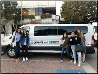
County Vanpool Incentive (SacRegion511)
Section titled “County Vanpool Incentive (SacRegion511)”Tenants and employees may utilize the vanpool subsidy program offered by SacRegion511.org. Newly formed vanpool groups may receive a $300 monthly subsidy for the first year.
The SacRegion511.org vanpool program partnered with Commute with Enterprise to provide an all-inclusive option to make vanpooling easy. A Commute with Enterprise vanpool comes with a newer model, low-mileage van, or SUV, with roadside assistance and maintenance.
Guaranteed Ride Home Measure
Section titled “Guaranteed Ride Home Measure”Guaranteed Ride Home Program
Section titled “Guaranteed Ride Home Program”The MAPPOA TSM Committee will establish a free guaranteed ride home program (GRH) under contract with Jibe. Employees who commute to work by transit, bike, walk, carpool, or vanpool qualify to participate in the Guaranteed Ride Home (GRH) Program.
The GRH Program offers a taxi or rental car voucher for personal emergencies.
It also applies when an employee unexpectedly must work late, missing the last bus or their regular carpool home. The GRH program alleviates objections and concerns about giving up their private automobiles, especially those with young families.
The Commuter Concierge will market the GRH program in all materials, communications, and fliers to educate employees about its value and benefit.
Parking Measures
Section titled “Parking Measures”No On-street Parking
Section titled “No On-street Parking”In coordination with park-wide parking guides, all streets throughout Metro Air Park have installed “No Parking” signs. No on-street parking ensures the availability of safe and clear bicycle lanes for those traveling by bicycle.
Pedestrian Pathway Through Parking
Section titled “Pedestrian Pathway Through Parking”Pedestrian circulation guidelines require clear, convenient pedestrian connections to business entries from public streets, sidewalks, transit stops, and trails. Differing paving textures, colors, and materials will distinguish pedestrian pathways from vehicular drive aisles through
Pedestrian pathways cross vehicular drives, delineated crosswalks, and raised pedestrian surface pavement ensure visual differentiation. Pathways will incorporate adequate lighting for pedestrian safety-design building footprints with offsets and recesses. Orient buildings to create courtyards and plazas to offer various gathering places.
Designated Mobile Food Truck Areas
Section titled “Designated Mobile Food Truck Areas”The MAPPOA TSM Committee will designate parking areas for mobile food trucks. Mobile food trucks reduce employees’ need to drive their automobiles to make a midday trip during lunch hours.
Mobile food trucks offer a variety of breakfast and lunch foods. This restaurant on wheels option fills a gap until retail projects develop in Metro Air Park.
Mobile food trucks and services offer the Commuter Concierge another opportunity to engage with commuters and promote events and campaigns.
Outreach, Marketing, and Promotional Measures
Section titled “Outreach, Marketing, and Promotional Measures”Metro Air Park Commuter Concierge
Section titled “Metro Air Park Commuter Concierge”Metro Air Park provides a dedicated TSM coordinator known as the Commuter Concierge as an essential amenity for all tenants and employees. The Commuter Concierge will help Metro Air Park reach their County required trip reduction goals and be responsible for implementing alternative commute programs.
The Commuter Concierge is an outsourced coordinator who manages the TSMP programs and annual reporting. The Commuter Concierge is responsible for; providing commute program assistance, producing on-site transportation fairs and promotional events, collaborating with transit and rideshare organizations to maximize on-site resources, partnering with Jibe, conducting the annual survey, and preparing annual summary reports. Commute industry data supports that a Commuter Concierge positively impacts increasing and maintaining alternative mode use.
The Commuter Concierge’s responsibilities will include:
-
Pre-occupancy engagement with tenants to transition drive-alone commuters to alternative transportation options before tenants move to the site
-
New employee orientation to alternative transportation options
-
Quarterly on-site promotions and events for all employees that highlight public transit, pedestrian and biking, and carpooling transit options and rewards
-
Support tenants with their Employee Wellness/Health/Commuter Transportation Fair/Earth Day/Bike to Work Day/Spare the Air events and promotions
-
Support tenants with coordination and formation of vanpools
-
Robust surveys of tenants and their staff to ensure compliance
-
Report TSMP performance to the County.
The Commuter Concierge is the direct contact for tenants and commuters. Below is a summary outline of the Commuter Concierge’s start-up and TSMP implementation functions.
- Develop MAP program policy guides
- Parking/parking mgmt.
- Carpool parking
- Vanpool parking
- Bicycle parking
- Guaranteed ride home
- Bike share
- Scooter share
- Prepare content for the MAP commuter resource website
- Commuter resources
- Commuter incentives
- Guaranteed ride home program
- Commuter assistance
- On-site facilities map (see page 17)
- Marketing, resource flier, FAQs, and promotions content
- Pre-occupancy tenant/employer support
- Employee presentations
- Pre-move baseline employee survey
- Commuter webinars
- Tenant support
- Trip planning assistance
- Integrate with SacRegion511
- Integrate with Sacramento Regional Transit
- Integrate with Yolobus
- Integrate with JIBE
- Annual employee commuter survey
- Tenant/employer engagement
- Determine what tenant commuter benefits employees receive
- Transit subsidies
- Vanpool subsidies
- Carpool incentives
- Bicycle incentives
- Create an employer/tenant primary TSMP contact database
- Explore MAP shuttle interest
- Develop a TSMP responsibility matrix
- Determine what tenant commuter benefits employees receive
- MAPPOA TSMP Committee commuter advisory support and technical assistance as needed
- Develop MAP program policy guides
Commuter Marketing and Promotion Measures
Section titled “Commuter Marketing and Promotion Measures”Marketing and promotions focus on both initial and long-term use of alternative modes of transportation. Employees will receive invitations to participate in Metro Air Park commuter and transportation promotions and campaigns such as:
- Special promotions and incentives to ride public transit
- Newsletters, emails, and Instagram postings
- Polls, surveys, or competitions to win prizes or a lottery
- Commuter newsletters and posters
- Spare the Air Days
- Bicycle Safety Workshops
- Lunch’ n learn events
- May is Bike Month
- Guaranteed Ride Home Program
- Ride matching assistance
The Commuter Concierge will share the commuter resource flier with tenants to promote employee services and benefits. An online Commuter Resource website will include links to bicycle, transit, carpool, vanpool, and guaranteed ride home programs. Also considered for future engagement use is a commuter app.
Property owners or tenants will receive a transportation kiosk from the Commuter Concierge for placement in an employee breakroom or entrance lobby. The kiosk contains transportation information such as bus and shuttle schedules, bicycle maps, commuter materials, guaranteed ride home information, and carpool ride-matching incentives.
Each tenant will promote the kiosk unit and resource materials for their employees to create a commuter corner. Information will be updated periodically by the tenant transportation coordinator.
The MAPPOA CC&Rs require property owners (and tenants) to participate in the TSMP. The MAPPOA will ensure property owners are aware of this requirement, and the Commuter Concierge will monitor their participation. Property owners will receive a MAP TSMP disclosure packet containing information and confirmation material, and the Commuter Concierge will collect a signed acknowledgment form for property owners. Below is a sample Metro Air Park Commuter Resource flier.
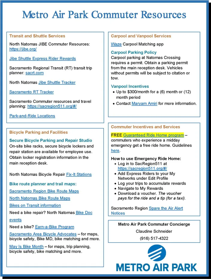
Monitoring and Reporting Measures
Section titled “Monitoring and Reporting Measures”Annual MAP Commuter Survey
Section titled “Annual MAP Commuter Survey”With the help of the MAPPOA TSM Committee, the Commuter Concierge will conduct yearly online surveying of all commuters within the park. The survey participation rate goal is 40%, and survey data will identify if the minimum number of persons is 1.5 per vehicle during peak travel. The online survey approach will include questions identifying when commuters arrive and depart from work. Travel data collected between 7-9 a.m. and 4-6 p.m. will reflect peakperiod times of days.
Metro Air Park SPA Section 505- 40.4.G.vi.j. states that “In the event that the peak period commute rate of 1.5 persons per vehicle is not being met, the [Transportation Systems Management] Association, known as the MAPPOA TSM Committee, shall propose additional and/or revised measures to the plan in a report to the Planning Director, which shall be forwarded to the Project Planning Commission.
The baseline commuter survey will occur at 25 percent of MAP’s occupied built environment. As of year-end 2021, only three buildings were occupied and operational. The TMA will monitor occupancies, and a baseline survey and report will be issued when required. The survey will rely on property owners, tenants, and employers to provide and promote commuter information and access links. The MAPPOA CC&Rs have enforcement powers, fines, and special assessments that can be levied if property owners or tenants do not participate in the survey.
Survey data will be used in the Annual Report Summary. An updated TSMP site plan will be included in the report and forwarded to the Department of Community Development. The Annual Commuter Survey Summary Report and applicable fees will be submitted by the indicated date.
Annual Employer (Tenant) Trip Reduction Permit
Section titled “Annual Employer (Tenant) Trip Reduction Permit”All applicant projects and tenant-employers operating in Metro Air Park with 100 or more employees will receive a copy of the County’s Trip Reduction Programs code. Employer engagement will be one of the activities handled by the Commuter Concierge team. Below is an excerpt from Chapter 10 of the County Code.
10.64.040 Permit Required.
Except as provided in Section 10.64.050, no person shall employ 100 or more persons at a common business location within the unincorporated urban area of Sacramento County without first applying for and obtaining a Trip Reduction Permit. Said permit must be obtained within 180 days of notification, as described in Section 10.64.080.
When a particular person has more than one common business location within the unincorporated area, each location employing 100 or more persons, that person may apply for and, subject to satisfactorily meeting the requirements of Section 10.64.140, may be granted a single Trip Reduction Permit applicable to all business locations described in the approved permit. (SCC 567 § 1, 1983.)
The Director of the Environmental Management Department will grant a Trip Reduction Permit after satisfactory compliance with the following requirements:
- Annually provide all employees and new employees upon hiring with written information on alternative commute modes, including carpooling, vanpooling, public transit, bicycling and walking to work. Such material shall include information on the benefits of these alternate modes and details regarding their availability to employees commuting to the worksite.
- Annually provide all employees and new employees upon hiring commuter matching services.
- Provide all employees with the services of an on-site employee transportation coordinator.
- Provide and administer a preferential parking program for carpool and vanpool vehicles at each work location. (SCC 567 § 1, 1983.)
Employer Trip Reduction Permits are valid for one year from the Director’s date of issuance. The Director may issue a Trip Reduction Permit, which is active for three years, to employers who continuously maintained a valid Trip Reduction Permit for two years or more.
Failure to obtain a Trip Reduction Permit or violation of the Trip Reduction Programs Chapter 10.64.010 may result in misdemeanor penalties and fines.
The Commuter Concierge team will help tenant-employees meet their Trip Reduction Permit requirements.
Other Measures
Section titled “Other Measures”Property Owner Performance Language - TSMP Requirements
Section titled “Property Owner Performance Language - TSMP Requirements”All property owners are required, via CC&Rs, to meet and perform the requirements identified in the Master Air Quality Mitigation Plan and the Transportation Systems Management Plan. As property owners submit project design plans to MAPPOA for approval, they will receive a letter reminding them of their and future tenant obligations to meet TSM requirements. They will receive a TSMP disclosure packet with information and acknowledgment confirmation material. The Commuter Concierge will collect and track the signed TSMP Packet acknowledgment forms.
Built projects will receive the updated TSMP Implementation Guide, packet of information, and acknowledgment form, tracked and collected by the Commuter Concierge.
The commuter trip reduction goals are the park-wide goal. The TSM Committee will determine how and when to meet goals and enforcement methods.
Property Owner or Tenant TSMP Employee Coordinator
Section titled “Property Owner or Tenant TSMP Employee Coordinator”Property owners or tenants will identify a designated contact to work with the Commuter Concierge team. The specified employer contact will share commuter information, marketing, outreach, and annual employee commuter surveys. The selected liaison may be the employee transportation coordinator (ETC), who will provide commute assistance to employees and maximize rideshare efforts.
Enforcement of tenants to identify ETCs are the responsibility of property owners. The Commuter Concierge will manage a list of ETC and property owner sites with tenants to encourage compliance. Should a tenant not comply or engage with the Commuter Concierge or identify an ETC, the MAP TSM Committee will identify consequences for the property owner.
Property Owner or Tenant Passenger Loading Area
Section titled “Property Owner or Tenant Passenger Loading Area”Project applicant requirements shall include passenger loading areas to meet the County’s Zoning Code ZC Sections 5.9.6.D & G.
Comply with MAP Master Air Quality Mitigation Plan (AQMP)
Section titled “Comply with MAP Master Air Quality Mitigation Plan (AQMP)”The MAPPOA TSM Committee complies with all mitigations necessary under the Air Quality Mitigation Plan. The TSMP Addendum intends to reduce total SOV trips and, in so doing, lessen resulting parking issues, traffic congestion, and mobile source-related air pollution. A comprehensive program of incentives and services can reduce parking demand, traffic, and air pollution, creating a more sustainable employment environment while freeing up valuable land for higher and better uses.
Best “SITE” for Commuters
Section titled “Best “SITE” for Commuters”The MAPPOA TSM Committee will seek the Best “SITES” for Commuters certification. The Best Workplaces for Commuters provides qualified sites with national recognition and an elite designation for outstanding commuter benefits. Development sites, tenants, and employers that meet the National Standard of Excellence in commuter benefits can get on the Best Workplaces for Commuters list. Metro Air Park is eligible for a Best “SITE” for Commuters designation as a business park workplace.
Association for Commuter Transportation
Section titled “Association for Commuter Transportation”The MAPPOA TSM Committee will join the Association for Commuter Transportation (ACT). ACT is an international association and leading advocate for commuter transportation and transportation demand management (TDM). Membership helps teams maximize their ability to recruit and retain employees and assist commuters with their commutes, with access to best practices for implementing useful TDM and shared-use mobility policies and programs.

Conceptual MAP On-site TSM Facilities Map
Section titled “Conceptual MAP On-site TSM Facilities Map”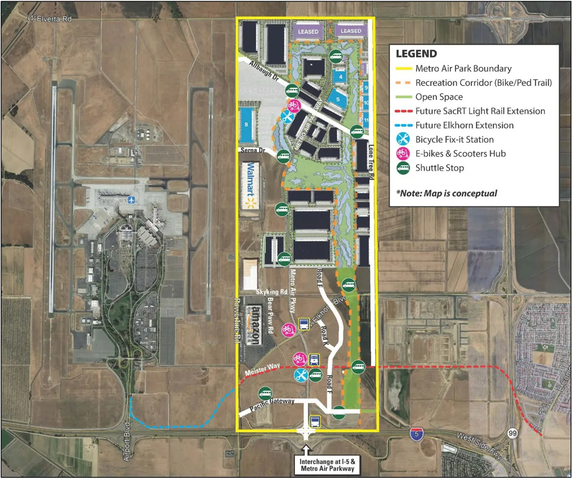
Updated 6/14/22
METRO AIR PARK MASTER AIR QUALITY MITIGATION PLAN (AQMP)
Section titled “METRO AIR PARK MASTER AIR QUALITY MITIGATION PLAN (AQMP)”Download the Metro Air Park Master Air Quality Mitigation Plan. This is an archived PDF document.