

Arden Arcade CP
Sacramento County Community Plans
Arden Arcade Community Plan
Section titled “Sacramento County Community Plans Arden Arcade Community Plan”Adopted November 6, 1980
Adopted by Resolution 80-1357Prepared by the Sacramento County Planning and Community Development Department
INTRODUCTION
Section titled “INTRODUCTION”The Arden-Arcade Community covers about 21 square miles northeast of downtown Sacramento. It is bounded on the north by Auburn Boulevard and Winding Way; on the east by Walnut Avenue and the southeasterly extension of Arden Way: on the south by the American River and the Sacramento city limits; and on the west by the Sacramento city limits.
As late as 1910, the area mow known as Arden-Arcade was still part of the “Haggin Grant”, a 44,000-acre piece of property north of the American River which was an old Mexican Land Grant to_ John Sutter. After 1910, the “Haggin Grant” was broken up, and by the start of World War II, a portion of five residential subdivisions had been recorded. However, much of the remaining Arden-Arcade area was held in large ownerships until after the War. In 1945, residential development was still nominal and included portions of Sierra Oaks Vista, the Sierra Oaks Tract, Bohemian Village, Bellview Village, Country Club Estates, and a few apartments on Marconi Avenue east of Fulton Avenue.
It was also in 1945 that what is now Town and Country Village was started at the intersection of Fulton and Marconi Avenues. It was the first integrated type shopping center in Northern California and was an immediate success because it was the only one available east of the Sacramento city limits. Most of the surrounding area was open ranch land, but soon independent commercial developments were spotted along Fulton and Marconi Avenues and Subdivisions were created by the dozens resulting in a complete suburban community in 10 to 15 years.
By 1966, the Arden-Arcade Community had 758 of its land area developed into urban uses. The major growth of population occurred from 1947 to 1960 when the average annual increase was more than 15 percent. That was more than 2-1/2 times the average annual rate of population increase for the total County area. As the amount of available land has decreased, the growth rate has also. The Arden-Arcade Community is now one of the most built-out and slowest-growing areas in the County. The average annual growth rate (compounded) is projected at about 0.5% for the remainder of the century.
Some of the land development problems which still exist in Carmichael, Fair Oaks and other parts of the northeast area are absent in Arden-Arcade because of the “Haggin Grant” preventing an early breakup of the area into small tracts of land. when development began after World War II, most of the land was open and free of scattered rural and semi-urban development. This made possible the development of many large scale well planned subdivisions throughout the Community.
However, the Community developed without an overall plan or an overall local government to guide the growth and several problems have resulted. Commercial uses have developed on lots designed for single family use; subdivision streets dead end against commercial or apartment development with no chance for the planned and still needed access, and single family homes which were planned in a homogeneous relationship with surrounding property now find themselves fronting, siding or in the midst of apartment house or commercial development. The changes of land use have created a large increase in traffic on major streets and thus created new friction with single family homes fronting onto them. With the increase in traffic have come noise and air pollution problems. Excessive traffic makes major streets less desirable as residential areas, leading to inadequately planned and buffered conversions to commercial uses. Lack of sign controls and landscaping requirements have led to sterile, cluttered, unsightly commercial areas.
These problems did not emerge overnight, and they are not susceptible to instant solutions. This plan contains proposals to maintain existing residential areas, control sign blight, regulate conversion of residential to commercial areas, and encourage transportation alternative to the automobile. These proposals and others will hopefully preserve the positive elements of the Community and help to improve the negative elements.
ARDEN-ARCADE GOALS AND OBJECTIVES
Section titled “ARDEN-ARCADE GOALS AND OBJECTIVES”- To maintain and enhance the distinctive character and identity of the Arden Arcade neighborhood.
- To develop an efficient, fully integrated and ecologically balanced transportation and circulation system.
- To work for the rehabilitation and enhancement of the major and minor commercial areas of the community in a phased effort.
- Relieve the burden upon Arden Arcade as the commercial and employment center of the unincorporated area.
- To insure a high level of quality in all physical development in the Arden Arcade community by formulating policies and regulations which will permit the two major elements of the community business and residential to exist together harmoniously.
- To provide for additional residential development by maximizing use of available properties which are suitable for housing.
- To prevent the encroachment of non-residential development on residential neighborhoods by insuring that non-residential land uses within or adjacent to residential neighborhoods are compatible with such residential development.
- To promote the availability of a full spectrum of housing in terms of design, type, cost, and suitability for a variety of life styles.
- To make the study area into a consolidated community by planning all facilities and services on a community-wide basis and working for the simplification of the governmental structure.
- To provide a wide range of recreational activities and facilities for the community.
- To maintain and preserve the valuable natural and historical resources of the Arden Arcade Community.
- To work for full implementation of all recommendations presented in the Community plan.
OBJECTIVE: To insure that the basic character of neighborhoods is preserved and strengthened by the adoption of neighborhood preservation area zones reflective of the peculiar character of each neighborhood.
OBJECTIVE: To establish logical, appropriate zoning districts on the Community Plan map which preserve residential areas from commercial intrusion.
OBJECTIVE: Discourage or eliminate, by strict regulation and standards, the conversion of residences to commercial uses.
OBJECTIVE: Increase the overall residential density of the community by converting vacant and marginal commercially zoned property to RD-20 or greater density and establish similar density on vacant lands along major thoroughfares which have mass transit routes.
OBJECTIVE: Alleviate traffic congestion at the intersections of Fair Oaks Boulevard and Howe and Watt Avenues by means other than grade separations.
OBJECTIVE: Physical improvements made and traffic management measures taken to alleviate congestion should not lead to visual or noise pollution for surrounding land uses.
OBJECTIVE: Develop an effective public transit system to serve the entire Sacramento Region and especially to lessen congestion On the surface arteries within the Arden Arcade community.
OBJECTIVE: Require provision of bike lanes and sidewalks in appropriate areas where these improvements do not exist now. An example of such improvements are sidewalks within parking lots.
OBJECTIVE: Regulate and integrate signs with architectural plans to reduce visual clutter, prevent confusion, reduce accidents and increase parking efficiency.
OBJECTIVE: Require bus turnouts and shelters at all shopping areas including existing centers and establish a means to obtain use of commercial parking areas as park and ride facilities.
OBJECTIVE: Cooperate with other planning authorities to investigate and promote public transit, pedestrian and bicycle access to commercial areas.
OBJECTIVE: Achieve Countywide enforcement of landscaping and sign regulations.
OBJECTIVE: Achieve an upgrade in landscape standards by adoption of a strong tree planting and preservation ordinance.
OBJECTIVE: Reduce visual clutter along the major arterials by establishment of a sign corridor zone and by amendment of the Zoning Code to require removal of non-conforming signs whenever businesses change.
OBJECTIVE: Implement Code provisions for planning staff review and approval of development plans when staff is available.
OBJECTIVE: Limit strip commercial zoning by refusing commercial zoning requests on parcels less than 300’ in depth.
OBJECTIVE: Work toward the elimination of billboard signs whenever possible.
OBJECTIVE: To circumscribe the permitted limits of commercial development around the existing commercial shopping and business centers.
OBJECTIVE: Limit the expansion and encourage the reduction of space committed to auto commercial use and limiting the introduction of new operations to the area already committed to auto sales use.
OBJECTIVE: To insure that the quality, location and type of commercial establishments are closely related to the needs and demands of the local population. Refuse to permit the expansion of major commercial centers and the development of non-neighborhood commercial and business zones.
OBJECTIVE: To halt the proliferation of commercial strip development by encouraging developments to locate in well designed and appropriately situated neighborhood shopping centers or office complexes.
OBJECTIVE: To reduce the total commercially zoned acres of land in the community.
OBJECTIVE: Establish landscaping and sign controls which by involving the Community Council will allow the citizens of the community to determine how their community will develop.
OBJECTIVE: Encourage clustering of complementary uses.
OBJECTIVE: Provide for safe access to commercial establishments by motorists, bus riders, pedestrians, bicyclists and the parking lots.
OBJECTIVE: Adopt by ordinance the use of the floating setback concept to provide for more landscaping as a visual barrier from the street.
OBJECTIVE: Encourage home ownership opportunities by constructing new townhouses and condominiums and similar housing rather than converting rental units to ownership units.
OBJECTIVE: To provide additional sites for residential development by rezoning surplus commercial property which is adjacent to existing residential development.
OBJECTIVE: To encourage the infilling of existing residential areas with the type of housing units and lot sizes which are compatible with the existing units and lots.
OBJECTIVE: To encourage residential development so as to facilitate optimum use of transportation systems and to reduce travel time to employment centers.
OBJECTIVE: To encourage the rehabilitation of deteriorating housing and neighborhoods by providing incentives for renovation of areas where housing is deteriorating.
OBJECTIVE: To discourage the encroachment of commercial structures on residential neighborhoods.
OBJECTIVE: To preserve the residential character of existing residential areas by prohibiting the diversion of commuter traffic through such areas.
OBJECTIVE: To prevent business-related parking from overflowing into residential areas by requiring adequate parking wherever commercial development abuts residential areas.
OBJECTIVE: To preserve the residential character of existing residential areas.
OBJECTIVE: To preserve the unique qualities of established neighborhoods those with environmental, aesthetic or other special uniqueness.
OBJECTIVE: To encourage the development of a balanced housing stock which provides homeownership and rental opportunities for all current and future residents.
OBJECTIVE: To encourage the development of housing for those persons who have special structural or locational needs such as the elderly and handicapped.
OBJECTIVE: To encourage the development of energy efficient housing and housing designs which make use of the range of energy conservation technology.
OBJECTIVE: To encourage the availability of quality housing which is affordable to persons of all income levels.
OBJECTIVE: Encourage consolidation of service districts in the Arden-Arcade area when such action would improve the service to the whole area.
OBJECTIVE: Encourage the establishment of culturally, as well as physically, oriented activities and facilities.
OBJECTIVE: Provide open space areas throughout the community.
OBJECTIVE: Maintain existing open space and shared use facilities throughout the community:
OBJECTIVE: Prohibit any excessive grading of land.
OBJECTIVE: Maintain all trees in the community in a healthy state through disease control and by careful restriction of cutting, grading: construction and planting in and around all native trees.
OBJECTIVE: Encourage the maintenance of open spaces on private property.
OBJECTIVE: Preserve the natural habitat along stream courses for the use and enjoyment of individuals and the community.
OBJECTIVE: Identify and maintain or protect sites of historical significance in Arden Arcade.
OBJECTIVE: Support a capital improvement program for public improvements recommended in the plan.
OBJECTIVE: Monitor new development to insure that it conforms to the adopted land use.
OBJECTIVE: Periodically review, evaluate and recommend appropriate changes in the community plan.
POPULATION
Section titled “POPULATION”TRENDS
Section titled “TRENDS”The major growth in the Arden-Arcade Community took place from 1950 to 1960, when the annual increase was some 15%, the greatest in the County at the time. Today, the Arden-Arcade Community is one of the slowest-growing areas in the County. The annual average compound growth rate is projected at 0.5% by the year 2000. Population totals for the Community are compared with Sacramento County as a whole and with the unincorporated portion of the County in Table I. Table IA (in Appendix I) details the population for Arden-Arcade by minor zone.
TABLE I PAST AND PROJECTED POPULATION
Section titled “TABLE I PAST AND PROJECTED POPULATION”| Location | 1950 | 1960 | 1970 | 1975 | 1985 | 2000 |
|---|---|---|---|---|---|---|
| Sacramento County | 277,140 | 502,780 | 634,190 | 685,325 | 816,000 | 976,700 |
| Unincorporated Area | 103,570 | 311,110 | 367,166 | 411,182 | 474,800 | 572,500 |
| Arden-Arcade | 16,430 | 69,550 | 85,272 | 90,651 | 100,999 * | 103,171 * |
* SRAPC January 1980, Volume. 9, No. 3, E-150 Population Projections.
CHARACTERISTICS
Section titled “CHARACTERISTICS”The age ranges in Table II show that Arden-Arcade had a slight decrease in percentage of people under 34 years of age and an increase in percentage of people aged over 55 years, consistent with the Countywide pattern. Median age has consequently increased as shown in Table III. These changes are probably due to the general trend of a decreasing birth rate.
TABLE II AGE RANGES
Section titled “TABLE II AGE RANGES”| Age Range | Arden-Arcade | Sacramento County | Arden-Arcade | Sacramento County |
|---|---|---|---|---|
| 19 or Less | 27,695 (34.9%) |
246,568 (39.0%) |
24,288 (28.2%) |
231.127 (34.0%) |
| 20-34 | 18,163 (22.9%) |
134,880 (21.4%) |
24,208 (28.1%) |
171,046 (25.2%) |
| 35-54 | 22,375 (28.2%) |
155,261 (24.6%) |
21,942 (25.5%) |
161,089 (23.8%) |
| 55-64 | 6,707 (8.4%) |
50,058 (7.9%) |
9, 164 (10.6%) |
58,210 (8.6%) |
| 65+ | 4,342 (5.5%) |
44,741 (7.1%) |
6,554 (7.6%) |
56,756 (8.3%) |
TABLE III MEDIAN AGE
Section titled “TABLE III MEDIAN AGE”| Location | 1970 | 1975 | Change |
|---|---|---|---|
| Arden-Arcade | 28.5 | 30.6 | +2.3 |
| Unincorporated Area | NA | 27 | – |
| Sacramento County | 26.8 | 28 | +1.2 |
The population of Arden-Arcade, some 90 percent of which is Caucasian, is fairly homogeneously spread throughout the area in terms of numbers. Disparities are manifested in relation to the elderly, disproportionately large numbers of whom are found north of El Camino Avenue. Below-average figures for median incomes are recorded in many zones in the northwest and westerly zones of the Community. Ethnic identification information can be found in Table Iv. More detailed data, updated annually. is available from SRAPC.
TABLE IV ETHNIC IDENTIFICATION CF PERSONS RESPONDING
Section titled “TABLE IV ETHNIC IDENTIFICATION CF PERSONS RESPONDING”| Location | White | Black | Chicano | Other | No Response |
|---|---|---|---|---|---|
| Arden-Arcade | 77,438 (88.8%) |
1,089 (1.2%) |
1,107 (1.38) |
2,213 (2.5%) |
5,328 (6.2%) |
| Unincorporated | 121,290 (87.18) |
4,096 (2.98) |
2.890 (2.18) |
4,257 (4.98) |
6,166 (4.48) |
| Sacramento County | 197,572 (80.5%) |
13,076 (5.3%) |
9,187 (3.78) |
11,844 (4.8%) |
13,012 (5.38) |
DESIGN CAPACITY
Section titled “DESIGN CAPACITY”The Arden-Arcade community is near its fullest potential development, as very little vacant land remains. Changes in the land use zoning such as those which would allow single-family areas to be converted to multiple family areas, would probably be the greatest reason for continued population development. However, the design capacity (the ultimate population when the community is fully built) can be determined by multiplying the population per dwelling times the total number of dwellings expected for the future. In this case, the number of dwellings is the figure projected for the year 2000 by the SRAPC final E-150 projections. This method yields a potential holding capacity figure of 103,171 persons.
LAND USE
Section titled “LAND USE”The subject of land use deals with the question of how each parcel of land in a given area is presently used, to what uses the vacant lands (although few remain in Arden-Arcade) should be put, and what land uses are inappropriate and should eventually be changed.
An overall view of the Arden-Arcade Community reveals its character as a mostly developed community of residential and business uses. The single family residential development is located primarily east of Watt Avenue.
The medium density residential development is dispersed throughout the western portion of the community. The highest concentrations are in the Southwestern area, not coincidentally, near California State University. A strip of Marconi Avenue east of Watt also accommodates a large number of apartment projects.
Commercial development exists in strips along thoroughfares and in major shopping centers at Watt Avenue and El Camino Avenue, and at Marconi Avenue and Fulton Avenue. Fulton Avenue from Arden Way north to Interstate 80 constitutes the “Auto Sales Row” of the northeast area. It is proposed to phase out the proliferation of smaller, high turnover used car lots north of Marconi Avenue. The remaining thoroughfares west of and including Watt Avenue accommodate a diversity of commercial uses.
The community is largely built-out, and because of this, several zoning tools (i.e., Neighborhood Preservation Areas, Special Sign District, etc.) will be proposed in addition to updating land use and zoning designations in order to preserve and protect same areas while bringing about change in others.
SPECIAL PLANNING ZONES
Section titled “SPECIAL PLANNING ZONES”Neighborhood Preservation Areas (NPA’s) currently exist in Sierra Oaks Vista and Beyerford Heights to preserve rural estate areas with winding Class “C” streets. An emphasis on buffering residential from commercial uses is included in the Beyerford Heights NPA. Additional NPA’s are proposed for Arden Park, Arden Oaks, and Mariemont/Gordon Heights, each aimed at preserving the large lot character of these areas. Other areas are proposed for RD-4 and RD-3 zoning designations. These zones do not allow use permits for conversions to BP uses and should be adequate to protect such areas where more “standard” lotting patterns exist in the subdivision.
Special Planning Areas (SPA’s) to allow for closer Board of Supervisors control have been studied for several areas. One SPA covers 30 or so acres of abandoned freeway right-of-way near the intersection of Walnut and Cypress Avenues. This SPA addresses hospital/medical uses as well as residential inasmuch as the Eskaton Corporation (American River Hospital) owns the property. The second SPA covers property bounded by Fulton and Loma Vista Avenues.
Special Sign District - This ordinance originated to protect the Sunrise Corridor from a proliferation of pole signs. The Arden-Arcade Community has voiced strong recommendations for stricter sign control in commercial areas. and in light of that position the Special Sign District will be applied to several areas within the Community (see Appendix II).
Natural Streams Combining Zones - The Natural Streams Plan was developed to preserve the function, character and potential of the natural streams. Within the Arden-Arcade Community. this Plan includes Chicken Ranch Slough from Avenue. The (NS) Combining Zone will be applied as indicated on the Natural Streams Plan, and will be shown on the Land Use and Zoning Map.
RESIDENTIAL ZONES
Section titled “RESIDENTIAL ZONES”Residential land uses up through Residential Density 5 allow incidental agricultural uses on lots 20,000 square feet in size or larger. This allows the keeping of livestock for recreation or 4-H type activities, and growing of crops primarily for personal use. A brief description of the various residential land use zones follows:
Residential Density - 2
Section titled “Residential Density - 2”This category provides for large lot, single family residential uses. The maximum residential density is two dwelling units per acre.
Residential Density - 3
Section titled “Residential Density - 3”This category provides for large lot, single family residential uses. The maximum residential density is three dwelling units per acre.
Residential Density - 4
Section titled “Residential Density - 4”This land use provides for single family dwellings on somewhat larger lots than in a typical urban subdivision. The maximum residential density is four dwellings per acre.
Residential Density - 5
Section titled “Residential Density - 5”This category provides for typical urban subdivision development of predominantly single family dwellings. Some duplexes may be permitted under certain conditions. The maximum density is five dwelling units per acre.
Residential Density - 10
Section titled “Residential Density - 10”This category provides for duplexes, townhouses, and other low density multiple family development. The maximum residential density is ten dwelling units per acre.
Residential Density - 20
Section titled “Residential Density - 20”This land use allows medium density multiple family development up to 20 dwelling units per acre.
Residential Density - 30
Section titled “Residential Density - 30”This land use allows medium density multiple family development up to 30 dwelling units per acre.
Residential Density - 40
Section titled “Residential Density - 40”This land use allows medium density multiple family development up to 40 dwelling units per acre.
Mobile Home Park
Section titled “Mobile Home Park”This category is used for mobile home parks.
COMMERCIAL ZONES
Section titled “COMMERCIAL ZONES”General Commercial
Section titled “General Commercial”This category provides for a full range of commercial land use, from offices and retail sales to heavy commercial and quasi-industrial uses.
Limited Commercial
Section titled “Limited Commercial”This category is shown for retail sales and light commercial uses outside shopping centers.
Business and Professional
Section titled “Business and Professional”Business and Professional This category is shown for office uses not located in shopping centers.
Shopping Center
Section titled “Shopping Center”This land use provides for commercial uses located in shopping centers of varying sizes.
OPEN SPACE ZONES
Section titled “OPEN SPACE ZONES”Recreation
Section titled “Recreation”This designation is used for existing parks and various recreation linkages.
POLICIES
Section titled “POLICIES”In addition to those policies contained in the goals and objectives, the following is offered:
- Discourage Business and Professional zoning along Mission Avenue and Engle Road.
- Any commercial expansion or improvement should take into account present traffic circulation patterns and parking conditions and should not further negatively impact existing commercial development.
HOUSING
Section titled “HOUSING”EXISTING SITUATION
Section titled “EXISTING SITUATION”The overall density of existing residential development in the Arden-Arcade Community. is relatively low. A large majority of the residential acreage As a result, the single family mix is not expected to change much. The major activity in housing is the conversion of apartment complexes into condominiums. The FHA considers the Sacramento Region as “balanced” in relation to condominium conversions, but the potential exists for a lack of rental units as well as the displacement of renters. Condominium conversions are carefully reviewed in an attempt to minimize these impacts.
TABLE V-1: A COMPARISON OF RESIDENTIAL DENSITIES JULY 1980
Section titled “TABLE V-1: A COMPARISON OF RESIDENTIAL DENSITIES JULY 1980”| Zone | Acreage |
|---|---|
| I-1-A, R-1-B, RE-1, RE-2, RE-3, A-1-A | 8233 |
| R-2, RM-1, RD-10 | 357 |
| R-2A, R-3, R-TH, RD-20,RD-30 | 1136 |
| TOTAL | 9726 |
TABLE V-2: A COMPARISON OF RESIDENTIAL DENSITIES OCTOBER 1980
Section titled “TABLE V-2: A COMPARISON OF RESIDENTIAL DENSITIES OCTOBER 1980”| Zone | Acreage |
|---|---|
| AR-1, RD-1, RD-2, RD-3, RD-4, RD-5 | 7972 |
| RD-10, RM-1 | 172 |
| RD-20, RD-30, RD-40 | 1162 |
| TOTAL | 9306 |
RESIDENTIAL LAND USE
Section titled “RESIDENTIAL LAND USE”Arden Arcade is a predominantly residential community, though it plays a major role in serving the region’s business-professional and commercial needs. It is an express goal of the Community Plan to restrict further expansion of commercial concerns into residential neighborhood areas, and to upgrade and maintain neighborhood quality through the zoning implementing Land Use Element of this plan.
Attempts to increase residential densities near employment centers and along major transportation corridors are reflected in the land use zoning map of this plan. Care has been taken to provide appropriate separation and buffering between multiple family and lower density residential areas.
EXISTING HOUSING TRENDS AND DWELLING UNIT HOLDING CAPACITY
Section titled “EXISTING HOUSING TRENDS AND DWELLING UNIT HOLDING CAPACITY”The decade old trend of building apartment complexes rather than single detached units has given way to conversion of these apartments into condominiums. Construction of new units is expected to be slight given the limited amount of available land. Single family units have been slowly decreasing as a percentage of all dwelling units, while multiple family dwellings have been increasing. At maximum development, single family and multiple family units are expected to be nearly equal in number. The changes reflect modified social preferences as well as the increased prices of single family dwellings.
Housing density is increasing, and will continue to increase slowly until full development is achieved, but Arden Arcade will remain essentially a low density community with 4.4 dwelling units per residential acre. The Community Plan indicates an ultimate holding capacity of over 43,000 dwelling units.
TABLE VI
Section titled “TABLE VI”| Dwelling Units Type | 1979 | 1985 | 2000 |
|---|---|---|---|
| Single Family | 21,175 | 20,749 | 20,398 |
| Multiple Family | 19,171 | 19,108 | 20,478 |
| Mobile Homes | 425 | 425 | 425 |
| TOTAL | 40,771 | 40,282 | 41,351 |
LOW INCOME HOUSING
Section titled “LOW INCOME HOUSING”It has been for sane years both a national and state goal to provide “a decent home and a suitable living environment” for every resident. The 1978 SRAPC (Sacramento Regional Area Planning Commission) Housing Opportunity Plan indicates that the City of Sacramento has more than its share of low-cost housing, while the County falls short of its share. The County share in 1978 was 41,550; the actual number of 1ow-income units was 34,804, or 6,746 units short of the goal. The County goal projected for 1985 is an additional 15,300 units, of which 1,683 units (11%) are allocated to Arden-Arcade.
TABLE VII: NEW HOUSING PRICES FOR DETACHED BEDROOM HOMES
Section titled “TABLE VII: NEW HOUSING PRICES FOR DETACHED BEDROOM HOMES”| Year | Median Price | Annual & Increase |
|---|---|---|
| 1970 | $23,100 | |
| 1971 | 25,100 | 8.7 |
| 1972 | 27,400 | 9.1 |
| 1973 | 30,303 | 10.6 |
| 1974 | 35,700 | 17.8 |
| 1975 | 40,100 | 12.3 |
| 1976 | 45,100 | 12.5 |
| 1977 | 50,000 | 10.9 |
| 1978 | 61,000 | 22.0 |
Source: Sacramento Building Industry Association.
There are, however, a number of constraints and obstacles to achieving this balance of low-cost housing. Low income families are virtually priced out of the new housing market as evidenced by the fact that in the period 1970-75 new housing prices increased by 74% while household median income increased by only 28%. Additionally, the resale market for existing homes generally has been dollar competitive with the new housing market. Lack of incentive for the builder to build low cost housing, local citizen resistance to these projects, and the cost of codes and ordinances combine to constrain the achievement of these housing goals.
Houses are built to meet demand where it is most profitable, and the profitable demand is currently for single family detached homes for small families in the middle to upper income range. The risk is higher and the profit margin lower in building low cost housing. Two options open to the industry are to reduce the quality or to build smaller homes with fewer amenities, including mobile and modular homes which are accommodated by the Zoning Code. Planned Unit Development, Condominium and duplex units on the market may result in a lower median sales price. Mobile homes are generally viewed as threatening to long term neighborhood preservation and are therefore frequently opposed by existing neighborhood residents. Modular homes are still relatively uncommon and the demand is still for more expensive homes.
Local citizen resistance to low cost housing is prevalent for a number of reasons, including a perceived devaluation of neighborhood property value.
The building industry feels that less government regulation could free-up land supply and reduce housing costs for the middle income housing demand on a short-term basis. But environmental quality levels would go down while energy consumption would rise, and services would suffer. Resolution of the low-cost housing problem has not and will not for the foreseeable future be of great public concern.
POLICIES
Section titled “POLICIES”In keeping with the national and statewide goal to provide “a decent home and suitable living environment” for every resident, it is the policy of the Board of Supervisors to:
- Maintain and promote the distribution of residential uses and density prescribed by the Arden-Arcade Community plan in order to ensure a balance of rental and ownership properties, and to achieve a greater general uniformity of population composition.
- Promote the use of innovative and creative residential design concepts (including energy conservation considerations) such as planned developments and clustered housing units which protect natural amenities and enhance the social and aesthetic qualities of the Community whenever renovation or infill takes place.
- Encourage increased residential densities near employment centers and along major transportation corridors in conjunction with improved transit systems and service, as a means of increasing the housing supply.*
- Make every effort possible to comply with the County allocated number of low cost housing units for Arden-Arcade.
- Provide a level of public facilities and services that is necessary to maintain neighborhood quality and integrity as prescribed by the Community Plan.
- Retain the character of existing sub-communities within Arden-Arcade.
- Fair Oaks Boulevard shall remain a residential corridor extending from Arden Way to Monroe Street.
* Criteria for increasing densities can be found in the Housing Element Action Plan of the General Plan, Appendix 7, page 31.
COMMERCIAL
Section titled “COMMERCIAL”INTRODUCTION
Section titled “INTRODUCTION”The character of the Arden Arcade Community is greatly affected by the pattern of existing commercial development. Arden Arcade is the established commercial and business-professional center for most of the northern part of the County, and only recently has sane relief been seen through the development of the Sunrise Mall area in Citrus Heights. Improperly located and poorly designed facilities have resulted in traffic congestion, noise, air pollution and undesirable aesthetic effects. In addition, some areas of the community are experiencing blight caused by neglected maintenance of marginally successful or failing enterprises. Blighted commercial development in turn degrades the quality of surrounding uses, discouraging possibility for new development or rehabilitation of existing developments.
Commercial development in Arden-Arcade, including the range from Business and Professional to Shopping Centers, exists mostly west of Watt Avenue. Regional Shopping Centers exist at the intersection of Watt and El Camino Avenue (Country Club), Arden Way just east of Interstate 80 within the city limits (Arden Fair), and on a smaller scale, specialty basis, at Marconi and Fulton Avenues (Town and Country). Additional commercial uses are located on Fulton Avenue, Arden Way, Howe Avenue, and Auburn Boulevard in the form of commercial strips. The remaining commercial uses are dispersed throughout the community as neighborhood shopping centers and other scattered commercial and business-professional uses.
Discussion in the Commercial Element centers primarily on the appearance and effects of commercial uses on adjacent residential areas and the community in general. Although this plan does not support new commercial zoning within the community, pressure for conversion of single family residential uses to business-professional along major thoroughfares is an ever-present situation. In addition, visual upgrading of existing commercial areas through strict landscaping and sign ordinances is needed.
PROBLEMS
Section titled “PROBLEMS”- Conversions of Residences To Commercial Uses.
One of the most visible problems in the Arden-Arcade Community is the single family home on a major thoroughfare which has been converted to a business-professional or commercial use with inadequate parking and little, if any, landscaping. Often a home is purchased by an investor and ceases to be owner-occupied. The unit is minimally maintained and deterioration of buildings and landscaping results. This type of speculation should not be rewarded. Conversion to commercial should only be a solution of the last resort and then only under the strictest guidelines. Previous approvals have resulted in substandard developments in many cases, and are not a solution.
SOLUTION
In an attempt to alleviate the problem, a set of evaluation criteria has been prepared which may be applied by the Arden-Arcade Citizens’ Advisory Council in the review process (see Appendix II).
SOLUTION
Incentives for residential rehabilitation should be made.
- Residential-Commercial Interfaces.
Buffering of interfaces between commercial and residential properties is another area of major concern. The problem is related in part to development along major thoroughfares.
SOLUTION
Stricter standards are needed to protect residential areas from noise and visual intrusion of the commercial development, thereby preserving the interior neighborhoods.(see Appendix II)
- Auto Commercial Strip.
A main issue is the substandard characteristics of used car lots which experience frequent turnover in ownership and lack adequate building and landscape maintenance.
SOLUTION
Develop and apply improvement standards for application to used car lots.
- Open Space Within Commercial Areas.
A concept for development in general proposed by the Arden-Arcade Council is to create “a city within a park.”
SOLUTION
In order to implement this concept, stronger enforcement and strengthening of development standards, including landscaping and sign requirements, will be required.
SOLUTION
Establish a street tree planting program on major thoroughfares.
- Signs.
Identification signs and advertising signs can be regarded respectively as necessary evils and unnecessary evils. This statement sets the mood for discussion of signs as they are related to commercial development and the Arden Arcade Community. The confusing array of signs along commercial strips is probably the most evident form of visual pollution in any community. Coupled with the advertising billboards, these structures present the community with a significant negative aesthetic impact.
SOLUTION
Improvement in this area will require, once again, a strict ordinance which will in part require identification signs to be on building faces, and existing free-standing and billboard signs to be phased-out over a reasonable period of time. A Special Sign District already in effect in the Sunrise Mall area is proposed to cover most of the commercial zoning in the Arden-Arcade Community. (See Appendix II or Section 335-60 of the Zoning Code for Special Sign District)
PROGRAMS
Section titled “PROGRAMS”PROBLEM: LOW DENSITY RESIDENTIAL CONVERSION TO COMMERCIAL
Section titled “PROBLEM: LOW DENSITY RESIDENTIAL CONVERSION TO COMMERCIAL”RESOLUTION: STRONGLY DISCOURAGE
PROGRAMS:
-
Only consider conversion requests to higher density residential uses.
-
Application by the Council of conversion standards to use permit and rezone requests (see Appendix II). Generally conversion requests will be considered only when several adjacent units apply as one and all improvement standards can be met.
PROBLEM: EXTENSION OF COMMERCIAL ZONING STRIPS
Section titled “PROBLEM: EXTENSION OF COMMERCIAL ZONING STRIPS”RESOLUTION: STRONGLY DISCOURAGE
PROGRAMS:
-
Residential to commercial or business and professional uses should be carefully evaluated. (See Appendix II.)
-
Approve new commercial zoning only when proposed as a neighborhood or larger shopping center.
PROBLEM: LACK OF VEGETATION
Section titled “PROBLEM: LACK OF VEGETATION”RESOLUTION: ENFORCE CODE, UPGRADE STANDARDS
PROGRAMS:
-
Adopt a stronger tree preservation ordinance.
-
Establish a street tree planting program.
-
Initiate a re-evaluation of the landscaping standards for the IC, SC, GC, AC, & TC zones.
-
Establish a joint Arden Arcade Council/Business Community Group to explore methods to achieve upgrading of commercial strips. Report to Board January 1982.
PROBLEM: A CONFUSING ARRAY OF SIGNS
Section titled “PROBLEM: A CONFUSING ARRAY OF SIGNS”RESOLUTION: REMOVAL OF ILLEGAL/NON-CONFORMING SIGNS
PROGRAM:
-
Adopt the proposed Special Sing District Ordinance ( Section 335-60 of the Zoning Code) for those strips identified on the land use map.
-
Bring existing commercial uses up to current zoning standards.
CIRCULATION
Section titled “CIRCULATION”INTRODUCTION
Section titled “INTRODUCTION”The Arden-Arcade Community has the heaviest traffic flow of any suburban area in the county. This fact underlies all discussion of transportation in the Arden-Arcade Community. Traffic flows from 1979 counts approach 40,000 vehicles per day along Watt Avenue for its entire length within the community. In addition, major intersections such as those at Howe Avenue and Fair Oaks Boulevard, and Watt Avenue and Fair Oaks Boulevard convey in excess of 70,000 vehicles per day.
Over the past ten years, several major streets and especially major intersections have become seriously congested, disrupting the flow of traffic to and from home, work, and shopping. Although population in the Arden-Arcade Community increased only 5% from 1970 to 1975, traffic flows have increased as much as 7% per year within the Community for the last five years. Some of the major streets were not built to handle the current traffic loads, but widening of these streets to accommodate increased volumes poses a serious problem because of the existing development along the roadways. Street widening has resulted in a wide range of damages including increased noise, unusable front yards, elimination of street side shade trees, and increased pressure for residential to commercial conversions.
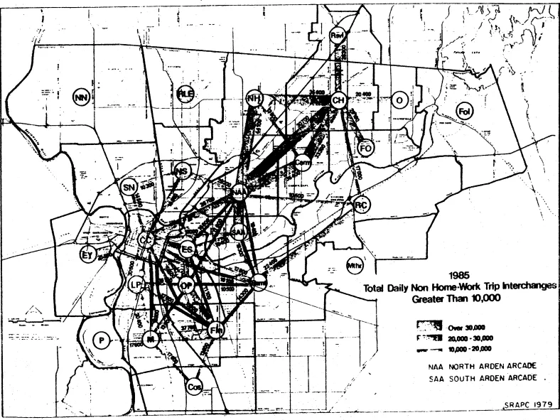
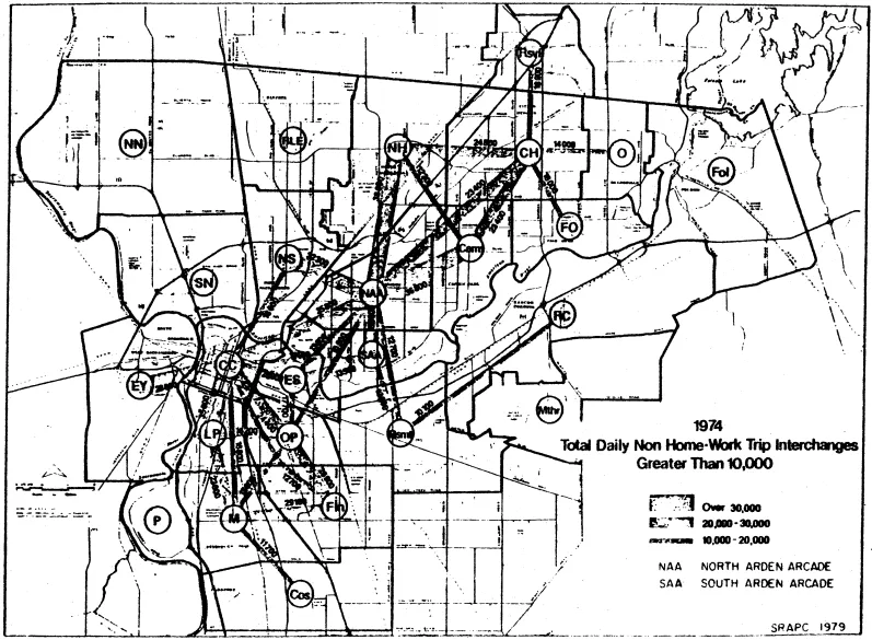
Traffic originates not only within the Arden-Arcade Community, but also without in the form of home-to-work and home-to-shopping trips to the various business and commercial centers which serve much of the Northeast Area. Traffic flows are heavy in both the east-west and north-south directions.
Local traffic congestion will continue to occur unless alternatives to the automobile are made available and utilized. In most cases, the car must be replaced wherever possible or trips diverted to other modes to alleviate local traffic congestion and to lower air and noise pollution levels. This implies designing a transportation system that provides for and encourages carpools, bicycling, pedestrians and mass transit as well as accommodating the automobile in individual use.
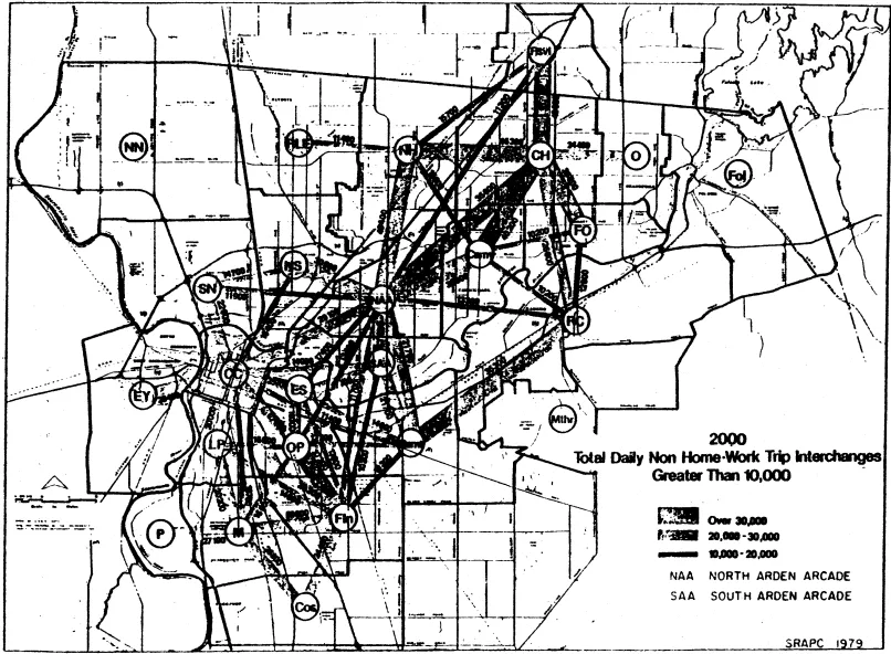
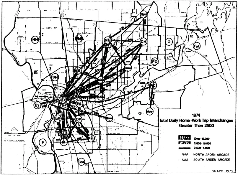
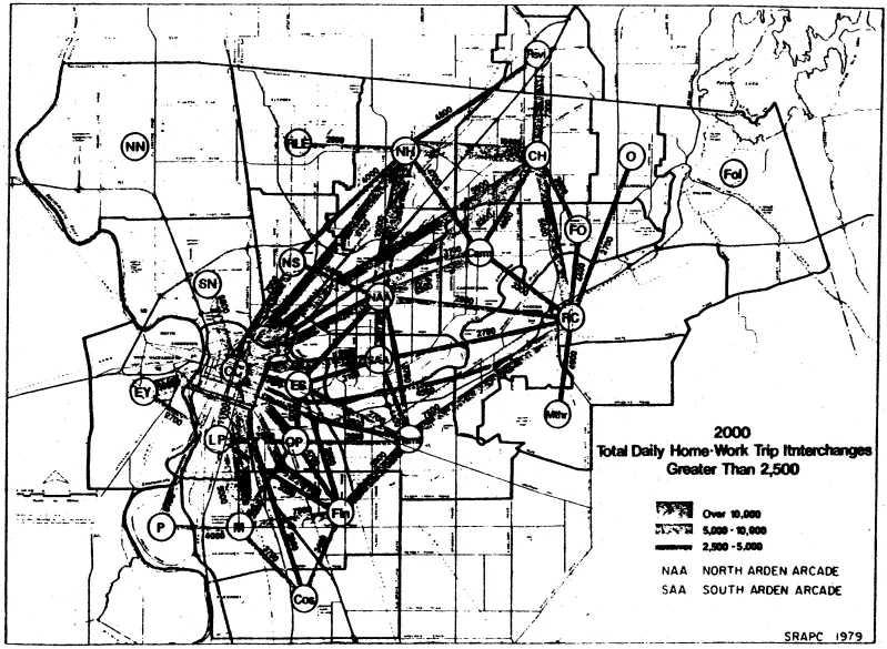
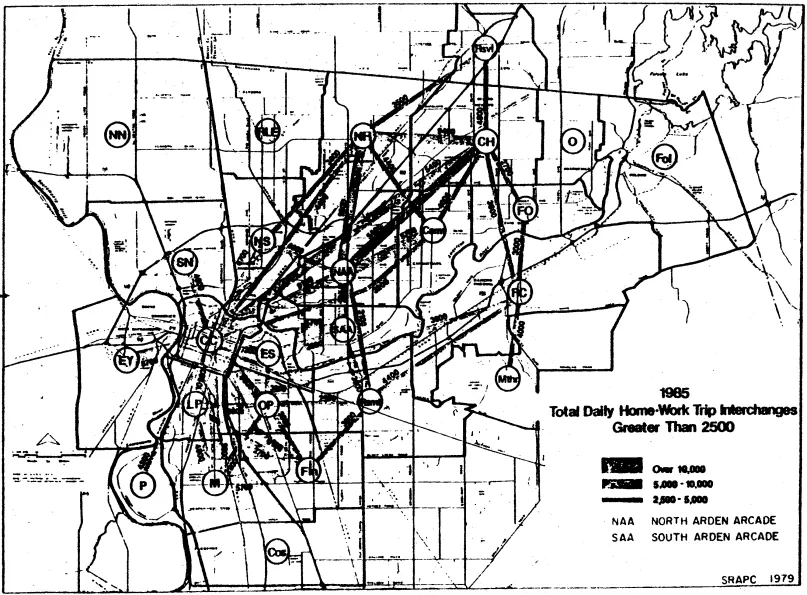
Supplemental maps and traffic projections are found in Appendix III.
Streets and Highways
Section titled “Streets and Highways”The network of streets having a width of 80 feet or more are referred to as major streets and highways. There are a number of sub-categories within this roadway network, including freeways, expressways, thoroughfares, and major arterials. Local streets are those streets having a width of less than 80 feet.
Freeways
Section titled “Freeways”Of the six major routes of access from northeast Sacramento County to downtown Sacramento, four (Interstate 80, State Highway 160, US Hwy. 50 and the Fair Oaks Boulevard arterial) are utilized by the Arden Arcade Community.
The first route is the existing I-80 freeway, which is fed by east-west suburban arterials. This route provides three traffic lanes in each direction except for a point at the junction of State Route 160 (SR-160) where it narrows to two lanes. Limiting factors along this route are the Marconi curve geometrics and the Arden Way undercrossing.
The second major route is a variation of the first. I-80 and SR-160 merge (or split) at Arden Way, with SR-160 providing more direct access to downtown. Most of SR-160 provides two traffic lanes in each direction.
The third route serves more distant northeast area communities and utilizes I-5 and I-880, diverting traffic around the Arden-Arcade area.
The fourth alternative is utilized primarily by the southerly portions of the Arden-Arcade Community. This route connects the Community with US 50 via Howe or Watt Avenue. US 50 has four lanes in each direction and is limited primarily by ramp capacity.
The fifth major route connects Arden-Arcade and also Carmichael to downtown by way of Fair Oaks Boulevard. Although not actually a freeway, this route is discussed here because it is a major link with the City and outlying communities. This route includes those streets connecting to Fair Oaks Boulevard and crossing the American River via the H Street Bridge. Fair Oaks Boulevard is two lanes in each direction and is limited by intersection congestion with Watt and Howe Avenues. Of the four routes serving Arden-Arcade, I-80 and Fair Oaks Boulevard are operating essentially at capacity, while SR-160 and US 50 could accommodate moderate increases in traffic. A study is currently being conducted by Sacramento Regional Area Planning Commission (SRAPC), Sacramento City Traffic Engineering, and California Department of Transportation, District 3 (CalTrans) to investigate the alternatives to construction of the I-80 Bypass through North Sacramento. This study’s primary emphasis is upon light rail. Several other alternatives are also under consideration, and decisions are expected to be reached coincidental with the completion of this plan.
Expressways
Section titled “Expressways”Expressways are major inter or intra-community streets with limited access, median dividers, four to six lanes, traffic lights and frontage roads as needed. The Alta-Arden Expressway is the only one in the community at this time and no others are currently proposed. The Alta-Arden Expressway extends from Watt Avenue westerly to an intersection with Arden Way just west of Ethan Way alleviating some of the pressure on Arden Way itself, although there are still serious bottlenecks on Arden way within the City limits.
Thoroughfares and Major Arterials
Section titled “Thoroughfares and Major Arterials”Thoroughfares and major arterials are virtually identical with the exception that thoroughfares may be divided and are somewhat wider, often six lanes. Both allow direct, although sometimes restricted access and do not require frontage roads. Generally, these streets collect traffic from residential streets and distribute it to the freeways. In the Arden-Arcade Community intersections pose the more serious traffic problems, while the link capacity on arterials appears to be adequate.
The only thoroughfare in Arden-Arcade is Watt Avenue which consists mostly of six lanes running north-south, splitting the Community into somewhat equal east and west portions. Problems with Watt Avenue occur primarily at intersections with other major arterials, a discussion of intersections is found in the following section. The other north-south major arterials are Howe, Fulton, Eastern and Walnut Avenues, all consisting of four lanes for most of their lengths. They are all 80 foot width streets which connect to Fair Oaks Boulevard in the southern portion of the Community.
The east-west arterials include Marconi and El Camino Avenues, Arden Way and Fair Oaks Boulevard. Marconi, El Camino and Arden are 80-foot streets with four lanes extending from Walnut Avenue at the Community’s eastern boundary westerly to Interstate 80. Fair Oaks Boulevard is four lanes from Walnut Avenue to the City limits. Although it is shown on the County’s General Plan as a 100-foot street from Eastern Avenue to the American River, the Community is strongly opposed to any widening of Fair Oaks Boulevard.
Link capacity on these streets is adequate at this time with most problems occurring during peak traffic hours and then only at certain intersections in the westerly portion of the Community.
Local Streets
Section titled “Local Streets”Local streets are generally from 60 to 42 feet in width and are basically residential access and feeder streets which move cars from homes to major streets. Most of these streets in the Arden-Arcade Community are Class “C” with only dirt ditches for frontage improvements, or Class B with curbs and gutters. All streets in new subdivisions are Class “A” with sidewalks, curbs and gutters. Development of sidewalks in large lot areas is discouraged in order to maintain the semi-rural atmosphere, of which the Class “C” street is a part.
Regional Transit
Section titled “Regional Transit”Because of its residential-business mix and its proximity to the central city, the Arden Arcade Community lends itself well to alternative forms of transportation, including Regional Transit bus service. The Arden-Arcade Community is presently served by RT lines 9, 10, 11, 12, 13, 20, 21, 22, 23, 24, 25, 29, 39 , 49, 59, 80, 81, 90, 91, and 92.
These lines reflect a good provision of service to both inter-community and intra-community travelers within Arden Arcade, including weekend service. Because of the Arden-Arcade community’s position as a “satellite core”, it is imperative that the present level of RT service be maintained and continually monitored to encourage transit ridership.
Major improvements in transit service along the more congested Arden-Arcade arterials could alleviate much of the traffic problem and enhance proposed circulation improvements to these roadways. These transit improvements may include more frequent time intervals and more direct routing during the peak traffic flow period. Serious consideration should be given to providing a link from Howe Avenue to El Camino along the length of Fair Oaks Blvd., with service to the city.
Other Mass Transit
Section titled “Other Mass Transit”Mass transit in Arden-Arcade presently exists only in the form of the Regional Transit bus services and programs. Currently, there is a major transportation study having potential impact on the Arden-Arcade Community. This I-80 Corridor Alternatives Analysis is evaluating essentially transit-oriented alternatives which could improve the Arden-Arcade area transportation pattern. A light rail commute service, while a large undertaking, nonetheless may be a practical solution to many of the urban transportation problems.
Bicycles
Section titled “Bicycles”As stated earlier, the Arden-Arcade Community is a prime area for alternative transportation forms due to its location in relation to the rest of the County. In the last few years attention has been given to the utilization of bicycles as an excellent mode of transportation, especially considering the various benefits derived from their use: exercise, energy conservation, lack of noise and air pollution and general aesthetic qualities. County budget commitments should provide for the continual cleaning of bikeways and the development of separate bikeways. Legislation has begun to recognize the bicycle with Federal Highway Act funding of bicycle paths and facilities to be used as transportation.
PROBLEM AREAS
Section titled “PROBLEM AREAS”- Intersection Congestion
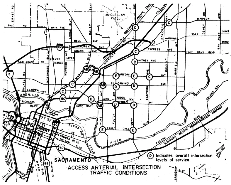
The analysis of traffic conditions on the arterial street system must be based upon the capacities of the at-grade intersections which generally control the capacities of the arterials. The intersections are analyzed to establish existing levels of service for the highest peak traffic period during the day. Most of the major intersections in Arden Arcade are operating over design levels under these criteria.Marconi Avenue intersections from Watt Avenue westerly to I-80 are operating at a critical level of service (E) with heavily congested traffic conditions and excessive delays. El Camino Avenue intersections with Watt and Fulton Avenue provide a poor level of service (D) with heavy approach traffic, long unstable queues and sometimes excessive delays. Arden Way from Watt Avenue westerly is also operating at a poor level of service (D) except for the Cal Expo intersection. Fair Oaks Boulevard intersections with Howe and Watt Avenues are heavily congested, and long delays are experienced at peak periods. Peak periods should not serve as the basis for planning of the circulation system.
Studies have been conducted by the City and County on the surface street problem with emphasis on intersection congestion. Some work has already been done at intersections such as Howe Avenue and Fair Oaks Boulevard. Major recommendations from the studies are summarized:
-
Consider improvement plans to facilitate the flow of traffic along the major arterial corridors need to be prepared with an emphasis upon long-term versus short term solutions. This is especially essential in the Howe and Fair Oaks corridors where the intersection improvements will in all likelihood develop congestion at downstream signals. Minimize curb cuts along major arterials through design standards.
-
As a part of corridor improvements, especially along Howe Avenue, the traffic signals should be interconnected.
-
It is strongly recommended that some form of mass transit system be constructed in the I-80 bypass corridor to meet the needs of the northeast area.
- Less Than Adequate Mass Transit
The key to solving the transportation problem is to convince people to use transportation other than the private, single occupant automobile. This is a complex task, involving the interaction of transportation Systems, land use, housing style, and life style. In terms of improvements in the transportation system itself, the best hope in the near term lies in improving service by Regional Transit. -
Fixed Route Service. A multi-destination timed transfer network is proposed, consisting of six major elements; major terminals, an artery route system, a local route system, a peak-hour express route system, improved frequency of service, and timed transfers. These six elements will function together so that the number of potential destinations from any given origin is maximized, travel time is reduced, and the number of transfers per one-way trip is minimized.
-
Special Service. In addition to regular fixed route service, the District operates a number of special transit services which are tailored to the unique needs of some District residents. These services include lift-equipped vehicles for the physically handicapped, contract para-transit services, special service for the retarded, charter service, and special services for the elderly. The District emphasizes a commitment to significantly improving para-transit service for the elderly and handicapped persons within the Sacramento area.
-
General Service to Meet Transit Needs. A significant expansion of service is proposed resulting in the following:
- A substantial reduction in mid-day travel times due to timed transfer scheduling and the artery route system.
- A greater percentage of homes within 1/4 mile walking distance of a bus stop.
- Direct north-south service which bypasses downtown.
- Expanded Saturday, Sunday and evening service.
- An increase in special services to the elderly and handicapped.
- Expanded service to activity centers such as shopping centers, medical centers, industrial complexes and military facilities.
- Wheelchair lift-equipped fixed route buses.
- Existing fleet and all new vehicles equipped with a "kneeling" feature to enhance boarding ease.
- Expanded passenger information services.
- Passenger waiting benches and/or shelters at many bus stop locations throughout Sacramento.
- Waiting stations located at major terminals equipped with restroom facilities and other passenger amenities.
-
The other major approach to mass transit at the present time emphasizes light rail systems in either or both the I-80 Bypass Corridor and the Folsom Corridor. The City and County are on record as supporting the concept. The necessary groundwork should continue. Light rail can carry large numbers of passengers and may prove to be a large part of the solution to surface congestion. As densities increase, the viability of such a system improves. In the medium and long run, light rail may be the answer.
- Less Than Adequate Bicycle Facilities
The Sacramento Bikeways Master Plan, adopted in 1975, designates numerous on-street bicycle lanes in the Arden Arcade Community in addition to the American River Parkway’s off-street trail. The majority of the planned on-street bicycle lanes in the Community have been implemented with the remaining ones to be completed within the next few years. Expanding usage of the bicycle as an alternative means of commuting will undoubtedly create new pressures on existing facilities. Research in the area of bicycle facilities and safety is currently experiencing a “boom”, this valuable information should be monitored and applied wherever possible.SOLUTIONS
-
Resume the operation of the City-County Bikeways Task Force, and charge them with the responsibility for defining commuter access to the central city.
-
Continue and expand efforts to make the public streets and off-street facilities as safe as possible for bicycle use.
-
Educate the bicyclist and the general public through bicycle safety programs and encourage the use of the bicycle.
-
Encourage bike commuting by providing adequate parking and “park and ride” facilities, including lock-up security for bikes.
-
Support the Sacramento Bikeways Master Plan.
-
Do not use bicycle funds for the improvement of automobile rights-of-way.
-
SOLUTIONS
SOLUTIONS
The Sacramento Regional Transit District General Plan for 1979-1984 in an effort to better meet the transit needs of the Sacramento community calls for a variety of improvements to the existing transit service as follows:
OPEN SPACE
Section titled “OPEN SPACE”Publicly owned and maintained open space is an important element of any community. The Arden-Arcade Community area faces a severe financial bind in the next few years due to at least three phenomena. First, the Community will continue to gain population with a corresponding increase in demand for open space. Secondly. the many recreation districts will find it increasingly difficult to finance maintenance with an increasingly limited property tax income relative to costs. Thirdly, the Community may lose some open space due to conversion of school sites to non-public uses.
The gain in population without a corresponding increase in park space will reduce the availability of space on an “as desired” basis. Individuals and groups will have to reserve ball diamonds, tennis courts, and picnic areas well in advance. Continual use will result in an acceleration of deterioration of facilities. The standard of five acres of open space for each 1000 persons is not currently met, and any reduction would simply make all park needs more severe.
The financial problems of the district cannot be resolved in the context of this plan. However, policies can be developed which can guide the decision making process as it relates to land use decisions. Regardless of the outcome of the public and legislative responses to recently approved constitutional amendments, money is not going to be available in large amounts for operation and purchase of park lands. Some near-term loss of open space is possible should any of a number of schools be sold as excess property by the San Juan Unified School District. Some of these sites are used weekdays and weekends as public open space whether by formal agreement between the park and school districts or simply by enterprising youngsters of all ages. When formal agreements exist, districts have made substantial improvements to school property without cost recovery should the joint agreement be terminated.
Problem
Section titled “Problem”Potential Loss of Open Space Due to the Sale of School Sites for Private Use
Solutions
Section titled “Solutions”-
Develop and adopt a public use zone to be placed on all public use property.
-
The Board of Supervisors should adopt as policy the position that co-developed sites should not be sold until local park districts have by a vote of their district electorate.
-
Whatever value is established for such co-developed sites, the sale price to the district should be appraised value minus improvement. costs.: In any case, public agencies are urged to provide property for purchase by other public agencies at below market rates (preferably the legal minimum):
APPENDICES
Section titled “APPENDICES”APPENDIX I
Section titled “APPENDIX I”TABLE IA: TOTAL POPULATION by Minor Zone
Section titled “TABLE IA: TOTAL POPULATION by Minor Zone”| Zone | 1975 | 1979 |
|---|---|---|
| 6541-000 | 1178 | 1117 |
| 6541-100 | 1519 | 1478 |
| 6541-204 | 2150 | 2850 |
| 6541-300 | 529 | 507 |
| 6541-304 | 0 | 298 |
| 6541-400 | 3 | 3 |
| 6541-500 | 1387 | 1424 |
| 6541-504 | 1326 | 1807 |
| 6551-000 | 2595 | 2444 |
| 6551-100 | 1791 | 1791 |
| 6551-200 | 1490 | 1406 |
| 6551-300 | 2760 | 3260 |
| 6551-400 | 3709 | 4130 |
| 6561-000 | 2022 | 1921 |
| 6561-100 | 305 | 357 |
| 6561-200 | 2008 | 2121 |
| 6562-000 | 3044 | 2911 |
| 6562-100 | 1057 | 1146 |
| 6562-200 | 3682 | 3730 |
| 6571-000 | 2760 | 2641 |
| 6571-100 | 943 | 898 |
| 6572-000 | 2471 | 2332 |
| 6572-100 | 2878 | 2717 |
| 6581-000 | 2742 | 2782 |
| 6581-100 | 2011 | 2222 |
| 6582-000 | 2326 | 2299 |
| 6582-100 | 1611 | 1606 |
| 6582-200 | 1825 | 1755 |
| 6582-300 | 1955 | 1863 |
| 6591-000 | 2433 | 2439 |
| 6591-100 | 2842 | 2775 |
| 6592-000 | 4069 | 3915 |
| 6592-100 | 2736 | 2602 |
| 6600-000 | 2170 | 2049 |
| 6600-100 | 383 | 364 |
| 6600-200 | 5023 | 4777 |
| 6600-300 | 3541 | 3489 |
| 6610-000 | 1146 | 1082 |
| 6610-100 | 3478 | 3404 |
| 6610-200 | 2839 | 2792 |
| 6621-000 | 2721 | 2728 |
| 6621-100 | 2101 | 1981 |
| TOTAL | 90,651 | 91,223 |
SRAPC E-150 Projections
1985 - 93,940
2000 - 99,239
Source: Sacramento Regional Area Planning Commission, 1975.
APPENDIX II
Section titled “APPENDIX II”EXHIBIT 1 SPECIAL SIGN DISTRICT
Section titled “EXHIBIT 1 SPECIAL SIGN DISTRICT”335-60 PURPOSE
Section titled “335-60 PURPOSE”The purpose of this Article is to regulate directory and nondirectory advertising structures in various places throughout the County so as to create a more attractive appearance in major shopping and business centers. The implementation of the regulations herein will enhance and protect the physical values of the community and at the same time reduce the distraction to motorists caused by numerous sign structures of various size and type of construction.
335-61 BOUNDARIES
Section titled “335-61 BOUNDARIES”The boundaries of the Special sign districts are shown on the various comprehensive zoning plans which are part of this Code.
335-62 DEFINITIONS
Section titled “335-62 DEFINITIONS”For the purposes of this Article certain words and phrases are defined as follows:
- SPECIAL SIGN DISTRICT. An area described in one or more Comprehensive zoning plans which the Board determines meets the requirements for special sign regulations.
- MONUMENT SIGN. An on-site sign which may be either a directory pole or nondirectory pole sign subject to the requirements of this Article and structural requirements of Title 18 of the Sacramento County Code.
335-63 REGULATIONS
Section titled “335-63 REGULATIONS”For property subject to this Article, the provisions of this Section relating to monument signs supersede and replace the provisions elsewhere in this Code which relate to and regulate directory and nondirectory signs.
- SIGN AREA. Monument signs shall be allowed an area of one (1) square foot per foot of the public street frontage with a maximum area of one hundred (100) square feet.
- LOCATION. Monument signs shall be located so that the part of the sign located closest to the street right-of-way line shall be set back not less than ten (10) feet from said public street right-of-way line and any property line.
- HEIGHT. The maximum height of a monument sign at 10-foot setback is ten (10) feet and may be increased one (1) foot for each foot of increased setback of the sign, providing, however, that the maximum height shall not exceed twelve (12) feet.
- SIGN SUPPORT. Width of the monument sign Support must be at least one-half (1/2) of the width of the sign face. For the purposes of this Section, the width requirements shall be applied to all project elevations of the monument sign.
- LANDSCAPING. Two feet of landscaping is required in every direction from the exterior portions of any part of the monument sign.
- ORIENTATION. Signs are mot allowed in controlled areas of visibility as determined by County Code Sections 12.12.010 and 12.12.020.
- ILLUMINATION. Illumination shall be interior lights Or spotlighted. Lighting filaments or gas tubes shall not be visible from adjacent property or public streets.
335-64 INTERPRETATION
Section titled “335-64 INTERPRETATION”This Article shall not be construed to limit the erection and maintenance of signs except as provided herein.
335-65 ADDED SIGN DISTRICT CONDITIONS
Section titled “335-65 ADDED SIGN DISTRICT CONDITIONS”In addition to this Specific “special sign district,” additional conditions of SPA, NPA, rezone, and use permits may be more restrictive than general provisions or development standards (sign regulations) for the zone classification.
Exhibit 2
Section titled “Exhibit 2”It is the policy of the Arden-Arcade Citizens’ Advisory Council that conversion of residential properties to BP uses in the Arden-Arcade Community shall be subject to the following standards: Development shall comply with the requirements of the BP Zone (Title II, Chapter 25, Article 3 of the Sacramento County Zoning Code) as well as other applicable Code requirements, with the following exceptions or additions:
PROJECT REQUIREMENTS: Each conversion project, whether one lot or more than one contiguous lot, shall be subject to the following standards:
- Project Area: Each project shall have an area of at least 20,000 square feet.
- Project Frontage and Width: Each project shall have at least 150 feet of public street frontage and an average width of at least 100 feet.
- Project Depth: Each project shall have a minimum depth of at least 300 feet.
- Front and Side Street Yard: Each project shall maintain a landscaped front yard and side street yard with trees planted at 30 feet on center of at least 25 feet.
- Rear Yard: Each project shall maintain a rear yard of at least 25 feet between any structure in the project and any residential, interim residential, interim estate, or recreation zone. If parking is provided in the rear yard, the minimum setback of the structure shall be 65 feet. A six-foot landscape buffer shall be provided along adjacent residential use boundaries.
- Interior Side Yard: Each project shall maintain an interior side yard of at least 20 feet between any structure in the project and the boundary line of any Residential, Interim Residential, Interim Estate, or Recreational zone. If a driveway is provided in the side yard, the setback shall be at least 35 feet.
- Parking lot landscaping shall result in shading of 50% of the parking area within 15 years of project approval.
- Driveways: Driveways shall be located a minimum of 150 feet from any street intersection and shall be at least 150 feet apart.
APPENDIX III
Section titled “APPENDIX III”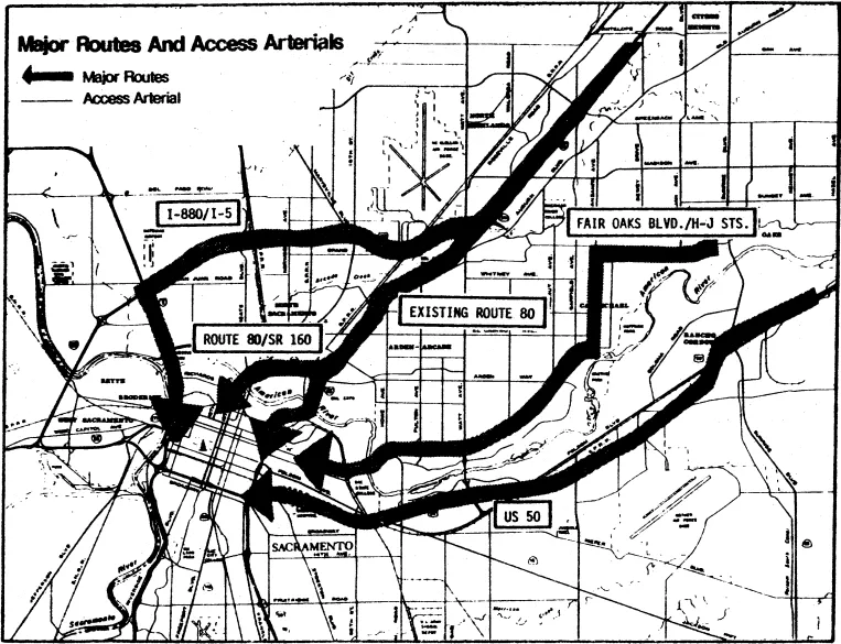
APPENDIX IV
Section titled “APPENDIX IV”LANDSCAPE AND SITE DEVELOPMENT STANDARDS FOR THE ARDEN-ARCADE COMMUNITY
Section titled “LANDSCAPE AND SITE DEVELOPMENT STANDARDS FOR THE ARDEN-ARCADE COMMUNITY”The Arden-Arcade Community Planning Advisory Council is particularly concerned with improving the standards for sign control, landscaping, and parking in the commercially-zoned areas of the Community. New standards need to be established on a County-wide basis. Until such standards are adopted, however, the Community wishes to see these standards established as policy for the Arden-Arcade Community.
Improvements which the Council advocates are:
SIGN CONTROL:
Section titled “SIGN CONTROL:”-
The removal of all billboards.
-
Monument signs only - one square foot per public street frontage. Maximum area 100 square feet. 1 per parcel.
-
Location of monument sign - so that the part of the sign closest to the street right-of-way line shall be set back not less than ten (10) feet from public street right-of-way line and any property line.
-
Height - maximum six (6) feet.
-
Width of the monument sign support - at least 1/2 width of the sign face.
-
Landscaping of two (2) feet in every direction from the exterior portion of any part of the monument sign.
-
No flashing, moving or animated illumination. Illumination by interior lights or spot lighted. Lighting filaments or gas tubes shall not be visible from adjacent property or public streets.
LANDSCAPING IMPROVEMENTS:
Section titled “LANDSCAPING IMPROVEMENTS:”-
Adjacent to all street rights-of-way:
- Minimum six (6) foot wide planter. Any curbing is in addition to this width. All zones except BP.
- Landscaping shall consist of shrubs, hedge, or natural growth designed to form a visual screen of a minimum of 3 feet in height. Landscaping not to exceed 2.5 feet in height at street and driveway intersections to assure visibility. 1 tree from county shade tree list planted every thirty (30) feet to give maximum shade and high canopy within 15 years of planting.
-
Adjacent or adjoining residential or BP, at the perimeter of the parcel:
- Trees from county screen tree list planted on thirty (30) foot centers in combination with other plant materials for dense visual screen.
- Planters a minimum of six (6) feet wide and thirty-six (36) square feet in area.
-
Parking lot requirements:
- A percentage of the paved parking area shall be shaded by tree canopies within fifteen (15) years of planting.
- 5-24 parking spaces: 30% shading
- 25-49 parking spaces: 40% shading
- 50 + parking spaces: 50% shading
- OR A standard of one shade tree for every 5 parking spaces.
- Trees a minimum of fifteen (15) gallon size at planting.
- Landscaping located throughout parking area to obtain maximum dispersion.
- A percentage of the paved parking area shall be shaded by tree canopies within fifteen (15) years of planting.
PARKING STANDARDS:
Section titled “PARKING STANDARDS:”-
Encourage shared parking areas and cooperative efforts to acquire land for parking so that present standards can be met.
-
Designs such as bays or frontage roads should be considered to decrease street access points and redesign parking areas as well as increase landscaped areas.
-
Encourage businesses to utilize the rear areas of their lots for parking, and increase the landscaped areas in front.
NEW COMMERCIAL BUILDINGS:
Section titled “NEW COMMERCIAL BUILDINGS:”-
High quality construction and design should be encouraged for all new construction.
-
Ample areas of vegetation should be planned to soften plain structures.
-
New sign, landscape and parking policy standards should apply.
RETROFIT OF EXISTING COMMERCIAL BUILDINGS:
Section titled “RETROFIT OF EXISTING COMMERCIAL BUILDINGS:”-
Enforce existing sign and landscape standards.
-
Encourage landscaping, and particularly trees, to be planted in existing 4-foot landscaped strips.
-
When application is made for a variance, use permit, building permit or parcel map, the new policy standards should be addressed and the commercial property should be brought up to the highest possible level.
STREET IMPROVEMENT PROJECTS:
Section titled “STREET IMPROVEMENT PROJECTS:”-
Landmark and Heritage trees should not be disturbed by street improvements.
-
The existing island areas along major arterials and frontage roads, should be landscaped, not asphalted, and trees with maximum shade potential and high canopies should be planted on 30-foot centers.
-
The existing area along Fair Oaks Boulevard between Howe and Monroe should be coordinated with the City of Sacramento in the type of tree planted.