

Chapter 3: Biological Resources Setting
South Sacramento Habitat Conservation Plan
Chapter 3: Biological Resources Setting
Section titled “South Sacramento Habitat Conservation Plan Chapter 3: Biological Resources Setting”3.1 Introduction
Section titled “3.1 Introduction”This chapter summarizes the baseline condition of the biological resources in the Plan Area, including South Sacramento Habitat Conservation Plan (SSHCP or Plan) definitions and descriptions of land cover types in the Plan Area, species addressed by the SSHCP, and a description of species habitat models used to quantify impacts and to prepare the SSHCP Conservation Strategy. Methodologies used to map land cover baseline conditions and map species suitable habitat (habitat models) are also discussed in this chapter.
3.2 SSHCP Land Cover Type Definitions
Section titled “3.2 SSHCP Land Cover Type Definitions”The land cover classification system developed for the SSHCP is a modification of the California Natural Communities classification system developed by the California Department of Fish and Wildlife (CDFW) (Sayer and Keeler-Wolf 1995). See Section 3.3 for information on the process used to define and map the SSHCP land covers.
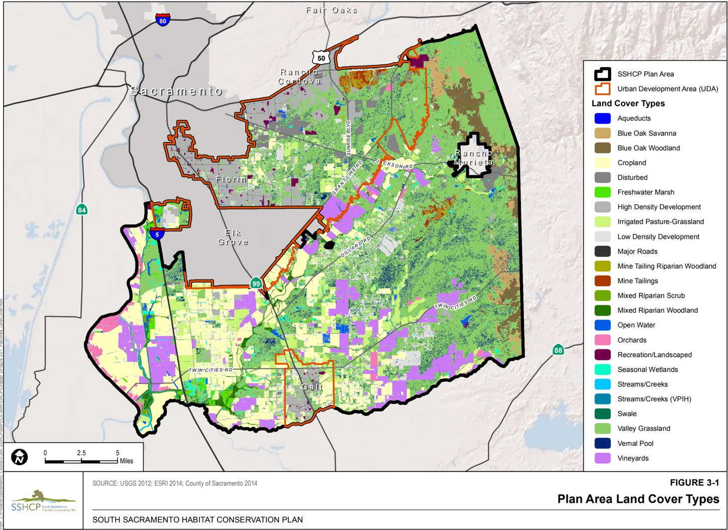
There are 24 SSHCP land cover types in the Plan Area. Seventeen land cover types are classified as ‘natural land covers,’ which includes native and naturalized environments and agricultural lands that have habitat value for SSHCP Covered Species (Sections 3.2.1 and 3.2.2). Seven SSHCP land cover types are classified as ‘developed/non-habitat land covers’ and provide minimal habitat value for native species, including the SSHCP Covered Species (Section 3.2.3). Table 3-1 lists the SSHCP land cover types within the Plan Area. Figure 3-1 shows the distribution of SSHCP land cover types in the Plan Area. As discussed in Section 1.2.1, the Plan Permittees divided the Plan Area into eight geographic subdivisions called Preserve Planning Units (PPUs) to assist with their development of an adequate SSHCP Conservation Strategy. The acres of each SSHCP land cover type in each SSHCP PPU are outlined in
Table 3-1 SSHCP Land Cover Types within the Plan Area
| SSHCP Land Cover Type | Natural Land Cover Category (have habitat value) | Natural Land Cover Category Area (Acres) in Plan Area | Percentage of Total Plan Area |
|---|---|---|---|
| Vernal Pool | Wetland Waters | 4,536 | 1.4 |
| Swale | Wetland Waters | 1,252 | 0.4 |
| Seasonal Wetland | Wetland Waters | 2,600 | 0.8 |
| Freshwater Marsh | Wetland Waters | 2,954 | 0.9 |
| Stream/Creek (Vernal Pool Invertebrate Habitat)* | Non-Wetland Waters | 73 | 0.02 |
| Stream/Creek | Non-Wetland Waters | 2,778 | 0.9 |
| Open Water | Non-Wetland Waters | 2,344 | 0.7 |
| Mixed Riparian Woodland | Riparian | 5,856 | 0.2 |
| Mixed Riparian Scrub | Riparian | 1,454 | 0.5 |
| Mine Tailings Riparian Woodland | Riparian | 641 | 0.2 |
| Valley Grassland | Terrestrial | 135,152 | 42.5 |
| Blue Oak Savanna | Terrestrial | 5,637 | 1.8 |
| Blue Oak Woodland | Terrestrial | 9,132 | 2.9 |
| Cropland | Terrestrial | 51,829 | 16.3 |
| Orchard | Terrestrial | 3,907 | 1.2 |
| Vineyard | Terrestrial | 26,460 | 8.3 |
| Irrigated Pasture | Terrestrial | 15,991 | 5.0 |
| Aqueduct | Developed / Non-Habitat | 264 | 0.1 |
| Disturbed | Developed / Non-Habitat | 6,288 | 2.0 |
| High-Density Development | Developed / Non-Habitat | 13,073 | 4.1 |
| Low-Density Development | Developed / Non-Habitat | 18,608 | 5.9 |
| Major Roads | Developed / Non-Habitat | 2,764 | 0.9 |
| Mine Tailings | Developed / Non-Habitat | 1,098 | 0.3 |
| Recreation/Landscaped | Developed / Non-Habitat | 2,180 | 0.7 |
| Not Mapped ** | Developed / Non-Habitat | 784 | 0.2 |
| Total | - | 317,655 | - |
Notes:
* Within the Urban Development Area portion of this Plan Area, occurrences of vernal pool tadpole shrimp (Lepidurus packardi), vernal pool fairy shrimp (Branchinecta lynchi), and mid-valley fairy shrimp (Branchinecta mesovallensis) have been found in certain intermittent streams, creek, and drainages. The SSHCP maps these streams, creeks, and drainages as Vernal Pool Invertebrate Habitat (VPIH).
Sections 3.2.1 and 3.2.2 present descriptions of each of the 17 SSHCP natural land cover types that provide habitat for SSHCP Covered Species and habitat for numerous other native species in the Plan Area.
3.2.1 SSHCP Aquatic Land Cover Types
Section titled “3.2.1 SSHCP Aquatic Land Cover Types”Vernal Pool Land Cover
Section titled “Vernal Pool Land Cover”Vernal pools are seasonal ephemeral wetlands that fill and dry each year. In Central Valley annual grasslands, they form in shallow depressions that are underlain with a soil or a soil layer impermeable to water. In California’s Mediterranean climate (rainy winter months followed by a hot, dry season), vernal pool soils typically become wetted in November. Water collects in the depressions and stands during late winter and early spring, then recedes as temperatures rise and rainfall diminishes. The soil, however, remains moist through April and May, then it desiccates and stays dry until the cycle begins again. The specific hydrological regime of vernal pool inundation-too short and unpredictable to support most aquatic species but long enough to eliminate upland species-is what characterizes vernal pools as ephemeral wetlands and differentiates them from other aquatic ecosystems such as alkali meadows and seasonally flooded emergent bulrush or tule marshes (Solomeshch et al. 2007).
Vernal pools support unique assemblages of highly specialized plants and animals that are adapted to the annual cycle of winter inundation and summer drought. Consequently, vernal pools are one of the few habitats in California still dominated by native plant and animal species (Rains et al. 2008). Many vernal pool plant genera and species are endemic to California, and their presence indicates the specific hydrology and water chemistry of the vernal pool. Vernal pools were once a very common element of the Central Valley landscape, but only a small portion has not been converted to agricultural and urban developments; consequently, many vernal pool taxa are now rare and endangered.
Vernal pools provide habitat for rare and endangered animals such as vernal pool tadpole shrimp (Lepidurus packardi), vernal pool fairy shrimp (Branchinecta lynchi), conservancy fairy shrimp, Ricksecker’s water scavenger beetle (Hydrochara rickseckeri), and several amphibians (e.g., western spadefoot toad (Spea hammondii), California tiger salamander (Ambystoma californiense)), and vernal pools support a number of migratory birds in the winter (Alexander 1976; Helm 1998; Silveira 1998; Solomeshch et al. 2007; USFWS 2004b). A specific group of plant taxa occupies vernal pools, most of which are annuals capable of slow underwater growth in winter and rapid development and reproduction in spring after the water is gone but before soils dry. Plant species are not distributed evenly through the pools, but grow in concentric zones that reflect different lengths of inundation as the pool dries (Solomeshch et al. 2007). As discussed in Chapter 2, Central Valley vernal pools occur on many geological surfaces, but in all cases, vernal pools are underlain by a low-permeability layer such as claypans, hardpans (e.g., silica-cemented duripans), mudflows, or bedrock (Rains et al. 2008). Because vernal pools are associated with specific landforms, geologic formations, and soils (Smith and Verrill 1998), vernal pools tend to be clustered at the landscape scale, forming vernal pool complexes (Rains et al. 2006). Based on a vernal pool’s landform, underlying geology, nature of the soil’s waterrestricting layer, frequency of ponding, and ponding duration, Sawyer and Keeler-Wolf (1995) have identified five vernal pool types in northern California. As discussed in Section 2.3, most vernal pools in the Plan Area are broadly classified as Northern Hardpan vernal pools and Northern Volcanic Mudflow vernal pools (Jones and Stokes 1990). In addition, a less specialized vernal pool type with generally lower species richness is found on Drainageway formation soils in the Plan Area.
Northern Volcanic Mudflow vernal pools occur on ancient mudflows called lahars (see Section 2.3). These pools are small, form in irregular depressions in gently sloping surfaces, and are often rocky and shallow. Water chemistry is mixo-saline, fresh (Sawyer and Keeler-Wolf 1995). In the Plan Area, Northern Volcanic Mudflow vernal pools are found on the Mehrten and Valley Springs formation in rocky soil series and complexes such as Hadselville-Pentz, Red BluffRedding, Corning-Redding, Amador-Gillender, and Pardee-Rancho Seco (Jones and Stokes 1990). Mudflow pools in the Plan Area are hydrologically complex; in some areas, vernal pools are in complex reticulated drainage networks with a high density of interconnected pools, swales, and ephemeral drainages (Jones and Stokes 1990). The seasonal hydrology of Northern Volcanic Mudflow vernal pools includes a perched water table (see Section 3.2.3), but pool hydrology is relatively ‘flashy’ (i.e., pools fill and drain relatively rapidly). Northern Volcanic Mudflow vernal pools contain relatively rich flora that includes several vernal pool obligate species. The species richness and ecological complexity of Northern Mudflow pools in the Plan Area exceed that of the Young-Terrace Northern Hardpan pools and the Drainageway vernal pools in the Plan Area. Possible explanations of the rich (less specialized) flora of Northern Mudflow pools include the recent origin of the pools and their quickly changing or ‘flashy’ hydrology. Mudflow pools fill and drain rapidly, and may be less stressful to most plant life than pools that remain flooded for extended periods, such as the Old-Terrace Northern Hardpan vernal pools (Jokerst 1990; Jones and Stokes 1990).
Northern Hardpan vernal pools form on alluvial terraces in old, acidic, nutrient-depleted soils with iron-silicate cemented soil layer. These soils often exhibit well-developed moundintermound topography to form aggregations of pools and ‘mima mounds.’ Water chemistry is mixo-saline fresh (Sawyer and Keeler-Wolf 1995). Northern Hardpan vernal pools typically have a conductivity of 40 to 70 mhos per 1 centimeter, which is similar to an oligotrophic high Sierran lake (Keeley and Zedler 1998; Williamson et al. 2005). Water in hardpan vernal pools is not only low in dissolved salts, but also in dissolved nitrogen. For example, Rains et al. (2006) reported that, during the growing season, nitrate and phosphate concentrations were below detection limits (i.e., 0.006 milligrams per liter (mg/L) and 0.03 mg/L, respectively), and the amount of ammonium was negligible (0.1 mg/L). Within the Plan Area, Northern Hardpan vernal pools occur on the low (younger) terrace Riverbank Formation soil series (e.g., San Joaquin, Galt, Madera, Tehama), as well as on the high (older) terrace Laguna Formation and Arroyo Seco gravels (e.g. Corning, Redding, Red Bluff, Mokelumne soil series). Vernal pools occur extensively on both landforms types (Jones and Stokes 1990).
The Plan Area’s Low-Terrace Northern Hardpan vernal pools (e.g., on San Joaquin soils) are of recent geologic origin, which may explain their relatively unspecialized flora that often includes non-native plants, low species richness, scarcity of vernal pool obligates, and low numbers of special-status plants. Most young terrace sites in the Plan Area have been plowed, graded, or heavily grazed because of their arable soils and proximity to reliable water; this may also account for their less specialized flora. Low-Terrace Northern Hardpan vernal pools also serve an important function as habitat for shorebirds, waterfowl, and raptors because of their location in the central portion of the valley along the Sacramento River (Jones and Stokes 1990; Silveira 1998).
High-Terrace Northern Hardpan vernal pools (e.g., on Corning and Redding soil series) are the most complex type of vernal pool in the Plan Area because of their rich and varied flora, presence of special-status plant and invertebrate species, and complex hydrology, and because they often occur in areas with complex, highly convoluted interspersions of several soil types. Soils on highterrace landform sites varies over short distances such that sites in proximity to each other may have entirely different restricting layer types, depth, and vernal pool plant community. HighTerrace Northern Hardpan vernal pools are floristically rich and dominated by vernal pool obligate plant species (true ‘specialists’), and typically support special-status species. The tremendous age and geographic location of High-Terrace Northern Hardpan pools may account for their rich and highly specialized flora (Jones and Stokes 1990). Little of the high-terrace landform has been farmed in the Plan Area because irrigation water is lacking and many sites are not arable. Some high-terrace vernal pool areas were dryland farmed in the past with wheat or oats; this type of farming appears to have had little effect on high-terrace vernal pools, while on other formations, this disrupted vernal pool surface hydrology. Consequently, High-Terrace Northern Hardpan vernal pools are relatively abundant in the Plan Area (Jones and Stokes 1990).
Drainageway vernal pools are located on no particular Plan Area geologic formation, but formed on recent alluvial deposits adjacent to the incised channels of active watercourses. Consequently, Drainageway vernal pools are interspersed throughout the other three vernal pool types present in the Plan Area. Drainageway vernal pools fill and drain rapidly, and may depend on overland runoff and direct precipitation to maintain their hydrology relative to the other vernal pool types (Jones and Stokes 1990). Additionally, the basins of Drainageway vernal pools are often shallow and susceptible to evaporation, or slightly sloped, which encourages drainage. Drainageway vernal pools have an unspecialized flora relative to the other three vernal pool types in the Plan Area (Jones and Stokes 1990).
The four types of vernal pools present in the Plan Area can be further classified by the presence or absence of certain dominant or less abundant vernal pool plant species (Sawyer et al. 2009). Vernal pool community structure (i.e., the type, number, and relative abundance of species) is largely determined by the pool’s physical makeup (e.g., size, depth, substrate, water chemistry) and the pool’s hydrology; different patterns of species dominance and the presence or absence of certain species can be indicative of physical and hydrology differences among vernal pools (Holland and Jain 1988). Vernal pools in the Plan Area exhibit a great variety of size, depth, soil, and water chemistry. Key physical parameters may include pool drainage area, slope, soil type, soil structure and depth, pool size and depth, timing of the pool hydrologic cycle, and pool interconnectivity. In particular, several SSHCP vernal pool Covered Species require large, deep pools that are long lasting to successfully complete their life cycles, including Boggs Lake hedge-hyssop (Gratiola heterosepala), Sacramento Orcutt grass (Orcuttia viscida), slender Orcutt grass (Orcuttia tenuis), vernal pool tadpole shrimp, California tiger salamander, and western spadefoot toad. Other vernal pool Covered Species are found in small to medium-sized ‘flashy’ pools that dry out relatively quickly, but may inundate and dry out several times during the wet season, including Ahart’s dwarf rush (Juncus leiospermus var. ahartii), dwarf downingia (Downingia pusilla), and pincushion navarretia (Navarretia myersii). For some plants in the latter category, the edges of larger vernal pools may provide conditions equivalent to the smaller, flashy pools. Other Covered Species associated with vernal pools include legenere (Legenere limosa), vernal pool fairy shrimp, Ricksecker’s water scavenger beetle, most of the bird Covered Species (mostly as foraging habitat), American badger (Taxidea taxus), and western red bat (Lasiurus blossevillii) (see Table 3-2).
Preserving the full range of physical and hydrologic conditions found in Plan Area vernal pools is necessary to ensure that all vernal pool Covered Species and representative examples of the different Plan Area vernal pool types and existing variation in vernal pool plant and animal associations are considered and protected (Jones and Stokes 1990). By protecting the range of diversity in vernal pool types, the SSHCP can ensure that the entire range of known and unknown ecological and biological values is represented in a Preserve System, and that the intrinsic values of this facet of the region’s natural heritage are considered. Preserving the range of plant and animal associations also provides natural laboratories to study the factors influencing the presence or absence of species, migration, and establishment of species, patterns of species dominance, and other phenomena (Jones and Stokes 1990).
Plan Area vernal pools occur in complexes of pools interconnected by intermittent surface swales and by the seasonal perched aquifer that forms between the soil surface and the subsurface restricting layer. Consequently, the Vernal Pool land covers in the Plan Area cannot be described or analyzed in isolation of their ecologically and hydrologically connected SSHCP land covers of Swale, Valley Grassland, and Stream/Creek (Vernal Pool Invertebrate Habitat [VPIH]). Therefore, in addition to discussing the Vernal Pool land cover individually in SSHCP Chapters 3, 6, and 7, the Plan Permittees also define and discuss an SSHCP Vernal Pool Ecosystem (see Section 3.2.3).
Seasonal Wetland Land Cover
Section titled “Seasonal Wetland Land Cover”Seasonal Wetland is a wetland that ponds for an extended period during a portion of the year. Seasonal Wetlands generally fill during the rainy winter season then dry relatively slowly, typically in the summer or early fall. Seasonal Wetlands tend to be isolated wetlands that occur within moderate to large depressional features along streams, creeks, and rivers; along the edges of open water, or scattered within the Valley Grassland land cover. In addition, some impounded drainages, excavated stock ponds, and graded or excavated former vernal pools can also be Seasonal Wetland. The Seasonal Wetland land cover is often characterized by herbaceous annual and perennial species such as curly dock (Rumex crispus), sedges (Carex spp.), nutsedges (Cyperus spp.), spikerushes (Eleocharis spp), and occasionally cattail (Typha spp.). Seasonal Wetland provides habitat for some Covered Species (Table 3-2). The SSHCP does not consider Seasonal Wetland to be suitable habitat for vernal pool crustaceans.
Covered Species associated with the Seasonal Wetland land cover include Boggs Lake hedge-hyssop, legenere, Sanford’s arrowhead (Sagittaria sanfordi), California tiger salamander, western spadefoot, giant gartersnake (Thamnophis gigas), all of the bird Covered Species (mostly as foraging habitat) except Cooper’s hawk (Accipiter cooperii), American badger, and western red bat.
Swale Land Cover
Section titled “Swale Land Cover”The movement of surface water between vernal pools can occur in a network of narrow and intermittent surface ‘swales’ (Solomeshch et al. 2007). Swales are shallow ephemeral drainages found in flat to gently rolling Valley Grassland in association with vernal pool complexes, on soils with an impermeable layer (see Section 2.3). Swales convey runoff as shallow, gently sloping ephemeral wetlands during, and for short periods after, winter rainstorms. Soils within the Swale land cover type may remain saturated during the winter and early spring, but dry by summer. Swales are associated with vernal pools and provide intermittent conduits between vernal pools for movement of surface water and propagules of vernal pool plant and animal Covered Species (seeds, cysts, eggs, and spores), and movement of adult California tiger salamanders and western spadefoots. Swales support several native plant species commonly found in vernal pools. Swales also often include smaller shallow depressional features that may pond during the rainy season to provide suitable reproductive habitat for some vernal pool Covered Species, and may be considered vernal pools. Generally, the Swale land cover provides suitable habitat for portions or all of the life cycle of many of the Covered Species that occur in the Vernal Pool land cover types, including Ahart’s dwarf rush, dwarf downingia, pincushion navarretia, mid-valley fairy shrimp (Branchinecta mesovallensis), vernal pool fairy shrimp, vernal pool tadpole shrimp, Ricksecker’s water scavenger beetle, and western spadefoot. In addition, all of the bird Covered Species (except Cooper’s hawk and greater sandhill crane (Grus canadensis tabida)) use Swale land cover (primarily as foraging habitat), along with American badger and western red bat (see Table 3-2).
The Swale land cover type cannot be adequately described or analyzed separately or in isolation of other ecologically and hydrologically connected SSHCP land covers (i.e., Vernal Pool, Valley Grassland, and Stream/Creek VPIH). Therefore, in addition to discussing the Swale land cover individually in SSHCP Chapters 3, 6, and 7, the Plan Permittees also define, discuss, and analyze a combined SSHCP Vernal Pool Ecosystem (see Section 3.2.3).
Stream/Creek Vernal Pool Invertebrate Habitat Land Cover
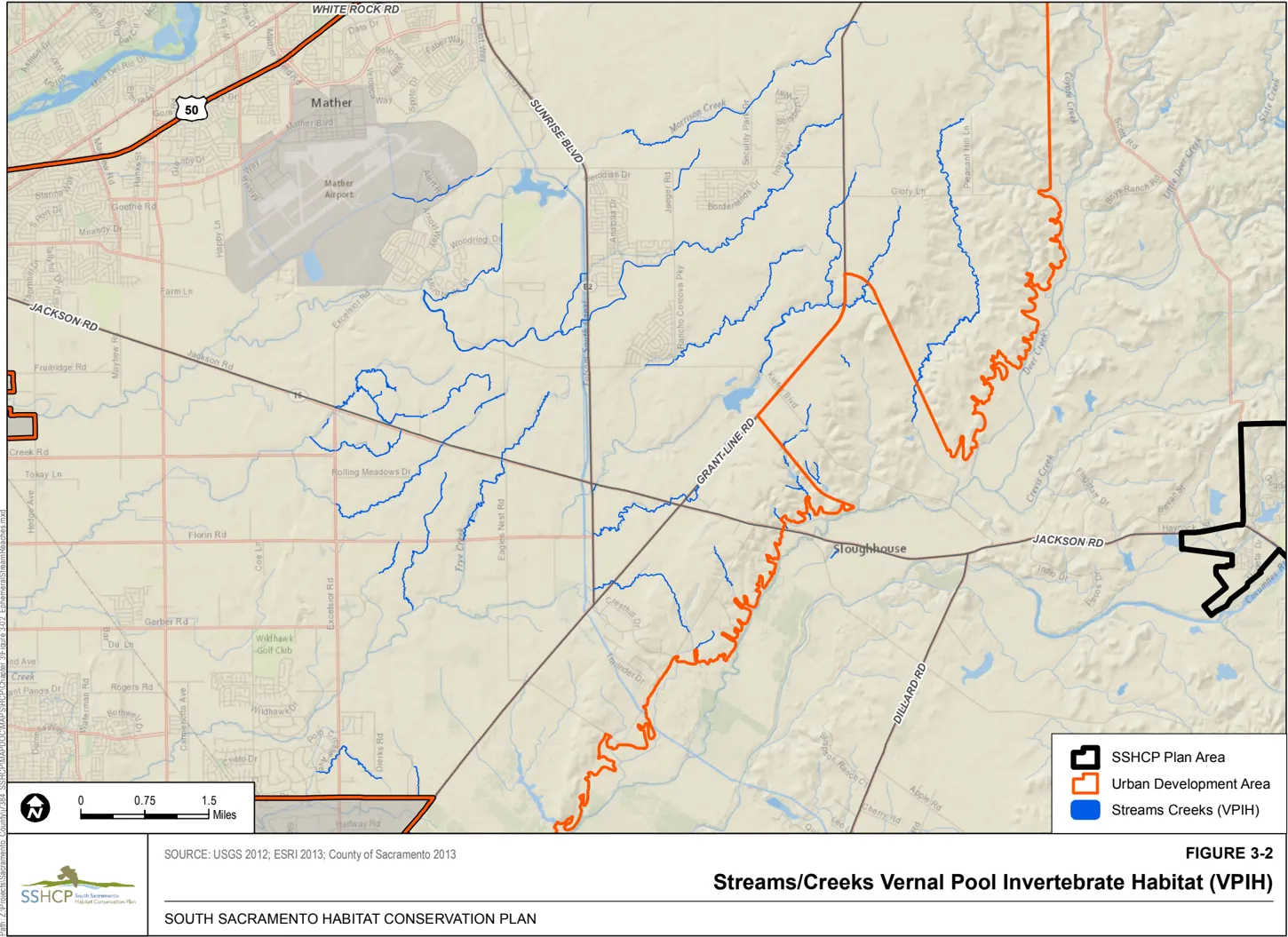
Section titled “Stream/Creek Vernal Pool Invertebrate Habitat Land Cover”As discussed below, the larger SSHCP Stream/Creek land cover type includes intermittent and perennial linear water features such as rivers, streams, creeks, and drainages. The SSHCP Stream/Creek VPIH land cover type is typically an intermittent drainage that is vegetated with Valley Grassland plant species and conveys water after rain events (is ephemeral). Unlike the Swale land cover type, the Stream/Creek (VPIH) land cover is less likely to support vegetation characteristic of vernal pools, and the SSHCP does not consider the Stream/Creek (VPIH) land cover habitat for vernal pool plant Covered Species. However, the Stream/Creek (VPIH) land cover is known to provide movement corridors, and may provide suitable habitat for vernal pool crustaceans, including mid-valley fairy shrimp, vernal pool fairy shrimp, and vernal pool tadpole shrimp, within depressional features of the drainage that pond water between storm events. Western burrowing owl (Athene cunicularia hypugaea) may also use Stream/Creek (VPIH) habitat. See Figure 3-2 for locations of Stream/Creek (VPIH) habitat.
The Stream/Creek (VPIH) land cover cannot be adequately described or analyzed separately or in isolation of other ecologically and hydrologically connected SSHCP land covers (i.e., the Vernal Pool, Valley Grassland, and Swale land covers). Therefore, in addition to discussing Stream/Creek (VPIH) individually in SSHCP Chapters 3, 6, and 7, the Plan Permittees also define, discuss, and analyze a combined SSHCP Vernal Pool Ecosystem (see Section 3.2.3).
Freshwater Marsh Land Cover
Section titled “Freshwater Marsh Land Cover”Most of California’s freshwater marshes occur in the Sacramento Valley and San Joaquin Delta regions. The majority of Freshwater Marsh in the Plan Area occurs along the perennial Cosumnes River and Deer Creek, and along the margins of streams and open water in the Plan Area. Freshwater Marsh is typically dominated by perennial herbaceous plant species such as cattails, tules (Scirpus spp.), and other emergent plant species, and is generally found along the edges of aquatic habitats such as ponds, lakes, and rivers. It is important habitat for western pond turtle (Actinemys marmorata), giant gartersnake, northern harrier (Circus cyaneus), tricolored blackbird (Agelaius tricolor), and western red bat (Table 3-2).
Open Water Land Cover
Section titled “Open Water Land Cover”Open Water includes perennial or features, such as natural or built ponds, lakes, and reservoirs. Open Water may contain no vegetation, or non-rooted aquatic vegetation, such as algae, floating pondweeds, and other plants. Along shorelines, rooted, emergent vegetation may occur, forming Freshwater Marsh. Like Freshwater Marsh, Open Water habitat is used by numerous bird, mammal, amphibian, and reptile species, including several Covered Species, such as western pond turtle, giant gartersnake, tricolored blackbird, and western red bat. The marshy shorelines may be used by tricolored blackbird for nesting colonies (Table 3-2).
The Open Water land cover type is found throughout the SSHCP Plan Area. Open Water features are largely unnamed with the exception of Blodgett Reservoir located inside the Urban Development Area (UDA) and Rancho Seco Lake outside the UDA.
Stream/Creek Land Cover
Section titled “Stream/Creek Land Cover”Outside of the UDA, the Stream/Creek land cover type includes intermittent and perennial linear water features such as rivers, streams, creeks, drainages, and roadside and irrigation ditches. Within the UDA, this land cover type includes streams identified by the U.S. Army Corps of Engineers. A separate category was created for aqueducts throughout the Plan Area.
The SSHCP Stream/Creek land cover includes rivers such as the Cosumnes River, streams such as Laguna Creek, and smaller intermittent or perennial creeks. The Stream/Creek land cover type was mapped from aerial photographs. Where a river or stream channel was not discernable because of dense over story cover, the centerline of the channel has been approximated and buffered by a width of 6 feet. Polygons of the Stream and Creek land cover occur in Valley Grassland, Blue Oak Woodland, Blue Oak Savanna, Agriculture, and Developed land cover types.
Covered species associated with the Stream/Creek land cover type include Sanford’s arrowhead, giant gartersnake, western pond turtle, and western red bat (Table 3-2).
Mixed Riparian Woodland Land Cover
Section titled “Mixed Riparian Woodland Land Cover”Riparian land covers are associated with Plan Area streams and creeks and typically occur in the zone between the active stream channel and adjacent upland land covers. While “riparian” has various definitions, the SSHCP uses the National Research Council’s 2002 definition:
“Riparian areas are transitional between terrestrial and aquatic ecosystems and are distinguished by gradients in biophysical conditions, ecological processes, and biota. They are areas through which surface and subsurface hydrology connect water bodies with their adjacent uplands. They include those portions of terrestrial ecosystems that significantly influence exchanges of energy and matter with aquatic ecosystems (i.e., a zone of influence).”
Riparian areas in the Plan Area are adjacent to perennial, intermittent, and ephemeral streams and lakes.
Riparian ecosystems are highly dependent on landscape setting and numerous physical and biotic interactions. Riparian ecosystems provide essential foraging, shelter, and breeding habitat for several of the Covered Species and other native plant and animal species, including both resident and migratory species.
The Mixed Riparian Woodland land cover type is distinguishable by an open canopy layer dominated by tall Fremont cottonwood trees. Beneath this open layer, a moderately dense midcanopy layer is composed of tree species such as Oregon ash (Fraxinus latifolia), Goodding’s willow (Salix gooddingii), walnut (Juglans spp.), valley oak (Quercus lobata), and box elder (Acer negundo). In some areas, a subcanopy of dense Riparian Scrub dominated by willow species, including arroyo willow and sandbar willow, is present. A discontinuous shrub layer is also present, particularly along the northern boundary of the Plan Area, and includes species such as blue elderberry, Himalayan blackberry, coyote-brush, wild rose, and wild grape. The ground layer is sparsely to densely vegetated with herbaceous species.
Included in the Mixed Riparian Woodland Land Cover Type are valley oak riparian woodlands. Although they are not a separate land cover type, owing to an inability to distinguish them from other riparian communities, valley oak riparian woodlands are notable as they were once a dominate community along waterways in the Plan Area. Valley oak riparian woodland intergrades with the Valley Grassland land cover type and wooded borders along streams and agricultural fields in the Plan Area. Tree associates in the Plan Area include California sycamore (Platanus racemosa), California black walnut, interior live oak (Quercus wislizeni), and box elder. The shrub understory includes western poison-oak, blue elderberry, California wild grape, and California blackberry (Rubus ursinus). Various grasses, including wild oats (Avena spp.), brome (Bromus spp.), barley (Hordeum spp.), and ryegrass (Lolium spp.), and other herbaceous, species may occur in the sparse to densely vegetated ground cover.
Covered species associated with the Mixed Riparian Woodland land cover type include valley elderberry longhorn beetle, western pond turtle, Cooper’s hawk, Swainson’s hawk, white-tailed kite, and western red bat (Table 3-2).
Mixed Riparian Scrub Land Cover
Section titled “Mixed Riparian Scrub Land Cover”Mixed Riparian Scrub land cover type is interspersed with Mixed Riparian Woodland in the floodplains of waterways throughout Sacramento County. In the Plan Area, this land cover type consists of an open to dense shrubby thicket dominated by a mixture of sandbar willow (Salix exigua), arroyo willow (S. lasiolepis), red willow (S. laevigata), and immature stands of mixed riparian woodland tree species (see description below). This plant community can also be a subcanopy community in Mixed Riparian Woodland. Though dense stands of Riparian Scrub in the Plan Area typically lack an understory, some of the more open canopy mixed Riparian Scrub stands do support an understory of native and non-native species, including wild rose (Rosa californica), wild grape (Vitis californica), perennial pepperweed (Lepidium latifolium), Himalayan blackberry (Rubus discolor), curly dock, and various non-native grasses.
Covered species associated with the Mixed Riparian Scrub land cover type include valley elderberry longhorn beetle, giant gartersnake, western pond turtle, Cooper’s hawk, loggerhead shrike, Swainson’s hawk, white-tailed kite, and western red bat (Table 3-2).
Mine Tailing Riparian Woodland Land Cover
Section titled “Mine Tailing Riparian Woodland Land Cover”The Mine Tailings Riparian Woodland land cover type is distributed in networks of relatively narrow linear areas that naturally established on abandoned mine tailing surface deposits in the Plan Area. This human-made land cover type contains species commonly found in Riparian Woodlands and Riparian Scrub habitats, such as Fremont cottonwood (Populus fremontii), blue elderberry (Sambucus mexicana), willow (Salix spp.), and coyote-brush (Baccharis pilularis). In the Plan Area, this land cover type can also intergrade with mixed riparian forest along bodies of water.
Covered species associated with the Mine Tailing Riparian Woodland land cover type include valley elderberry longhorn beetle, western pond turtle, Cooper’s hawk, loggerhead shrike, whitetailed kite, and western red bat (Table 3-2).
3.2.2 SSHCP Terrestrial Land Cover Types
Section titled “3.2.2 SSHCP Terrestrial Land Cover Types”SSHCP includes seven terrestrial land cover types. One are dominated by herbaceous vegetation (Valley Grassland), two have oak trees (Blue Oak Woodland and Blue Oak Savanna), and four are farming land covers (Cropland, Irrigated Pasture-Grassland, Orchard, and Vineyard).
Valley Grassland Land Cover
Section titled “Valley Grassland Land Cover”Valley Grassland is by far the most common single land cover in the Plan Area. Including nonhabitat land covers, it accounts for about 43% of the land covers in the Plan Area. Valley Grassland, being so widespread throughout the Plan Area, is essential for both the long-term survival of many of the Covered Species and for conserving ecological functions of other land cover types within the Plan Area.
Valley Grassland in the SSHCP Plan Area is an annual herbaceous plant community now characterized mostly by naturalized annual grasses. Generally, its composition in the Plan Area varies with geographic, and land use factors, such as rainfall, temperature, elevation, slope, aspect, grazing, and other herbivory (e.g., livestock, wildlife, rodent, songbird, and insect use), and fire frequency and duration. In the Plan Area, Valley Grassland is dominated by naturalized herbaceous annual forbs, and includes patches with relatively high proportions of native grasses and forbs along the eastern border of the Plan Area. Naturalized annual grasses that dominate the Plan Area’s Valley Grassland land cover include wild oats (Avena fatua), soft chess (Bromus hordeaceus), ripgut brome (B. diandrus), red brome (B. madritensis ssp. rubens), wild barley (Hordeum spp.), and foxtail fescue (Vulpia myuros). Common herbaceous forbs include the naturalized broadleaf filaree (Erodium botrys), redstem filaree (E. cicutarium), turkey mullein (Eremocarpus setigerus), true clovers (Trifolium spp.), and bur clover (Medicago polymorpha).
Valley Grassland in the Plan Area is associated with several natural communities, including vernal pools, and occurs as an understory within Valley Oak Riparian Woodland, Blue Oak Woodland, and Blue Oak Savanna. Valley Grassland also may occur as a co-dominant with perennial grasses within some of the areas mapped as Valley Grassland in the Plan Area. For example, purple needlegrass (Stipa pulchra) can be found as the dominant grass (i.e., comprising greater than 20% cover) in small patches along ridgetops of low-lying hills in the eastern portion of Sacramento County.
Valley Grassland supports numerous wildlife species, including several Covered Species. Covered Species associated with Valley Grassland included California tiger salamander, western spadefoot giant gartersnake, western pond turtle, all of the bird Covered Species (except Cooper’s hawk), American badger, and western red bat (Table 3-2).
As a critical element of the Vernal Pool Ecosystem, much of the Valley Grassland land cover within the Plan Area also supports vernal wetlands (i.e., Vernal Pools, Swales, and Stream/Creek-VPIH), and vernal pool-dependent species (vernal pool crustaceans and plants) (see Section 3.2.3). Approximately 97,349 acres of the total 135,152 acres of Valley Grassland present within the Plan Area (approximately 72%) are believed to be ecologically and hydrologically associated with Vernal Pools, Swales, or Stream/Creek-VPIH land covers to comprise the Plan Area’s Vernal Pool Ecosystem (see Section 3.2.3).
Cropland Land Cover (Row and Field Crops)
Section titled “Cropland Land Cover (Row and Field Crops)”Most of the Plan Area’s Cropland is concentrated in the western part of the Plan Area in the Sacramento River and Cosumnes River floodplains. Cropland includes annual row and field crops (e.g., small grains, corn, tomatoes, melons, peppers, safflower, sunflower) and short-term perennial crops (e.g., asparagus). Rice is a row crop grown in Sacramento County, but is seldom grown in the Plan Area. Small fields of rice have recently been planted on the existing Cosumnes River Preserve.
An important ecological function of Cropland in the Plan Area is to provide rodent and insect prey and plant material forage for a number of the bird Covered Species. Small rodents are important prey for raptors, such as Swainson’s hawks, white-tailed kite, and Cooper’s hawk. Western burrowing owls consume a mix of small rodents, arthropods, and other small animals. Loggerhead shrikes primarily prey on ground-dwelling insects but also take small rodents. Swainson’s hawks switch to a diet of insects after the breeding season. Greater sandhill crane is a winter visitor to the Plan Area and forages for seeds and small animals. Tricolored blackbird forages on invertebrates during the nesting season and plant material during the non-nesting season (Table 3-2).
Irrigated Pasture-Grassland Land Cover
Section titled “Irrigated Pasture-Grassland Land Cover”Irrigated Pasture-Grassland is fairly common, but occurs in a scattered distribution generally in the central portion of the Plan Area. The Irrigated Pasture-Grassland land cover includes hay production (alfalfa, clovers, and mixed grasses), seasonal summer pasture for livestock (primarily cattle), and year-round pasture for livestock (primarily cattle or horses). Seasonal pasture appears to be the most common use. Irrigated Pasture-Grassland is typically seeded, cut/grazed, and reseeded on a regular basis on an approximately 5- to 7-year cycle before the fields are left fallow to rest, and the cycle is started over again.
Within the Irrigated Pasture-Grassland land cover type, alfalfa fields provide by far the most productive foraging habitat for raptors and are used by other Covered Species, such as greater sandhill crane, and tricolored blackbird (Table 3-2). As a perennial crop grown for several years before removal and replacement, alfalfa provides good cover for rodents and time for establishment of a good prey base. Farming operations during the growing season consist of periodic flood irrigation and four to six mowings. Both types of operations result in temporary increases in prey availability.
Many of the Covered Species that use Cropland also use Irrigated Pasture-Grassland. Pasture is suitable tricolored blackbird foraging habitat if it is within two miles of a colony nesting site. Greater sandhill cranes use Irrigated Pasture-Grassland for roosting and foraging (Table 3-2).
Orchard Land Cover (Fruit and Nut Orchards)
Section titled “Orchard Land Cover (Fruit and Nut Orchards)”Orchards are scattered throughout the Plan Area, with the largest concentration along the western boundary of the Plan Area. The Orchard land cover has limited wildlife habitat value (Table 32), but provides perches for raptors foraging in adjacent Cropland and Valley Grassland. In particular, larger nut trees and other trees at these edge areas may be used by ‘sight predators’ such as Swainson’s hawk for perches to find prey in adjacent fields. Western red bat is known to roost in orchards, including apricot, peach, pear, almond, walnut, and orange trees (Constantine 1959; Pierson et al. 2006) (Table 3-2).
Vineyard Land Cover
Section titled “Vineyard Land Cover”Vineyard land cover is located mostly in the southern portion of the Plan Area outside of the UDA. In Sacramento County, vineyards are primarily established for wine grape production, with some minor table grape producers. Vineyards are primarily ‘clean cultivated,’ meaning no other vegetation is allowed to grow between the rows or on the edges of fields and irrigation ditches. As such, vineyards typically provide only limited habitat for native plants and wildlife (Table 3-2). However, vineyards using ‘environmentally friendly’ management practices may provide habitat value through use of bat boxes, raptor perches, and owl boxes to encourage presence of these species and reduce insect and predation damage.
Blue Oak Woodland Land Cover and Blue Oak Savanna Land Cover
Section titled “Blue Oak Woodland Land Cover and Blue Oak Savanna Land Cover”Blue Oak Woodland and Blue Oak Savanna comprise approximately 5% of the Plan Area, a majority of which is located in the far eastern portion of the Plan Area.
Blue oaks are typically drought-tolerant, and unlike interior live oaks, are deciduous, dropping their leaves during periods of extreme moisture stress. This survival trait may explain the observed patterns of blue oak distribution, with blue oaks occupying drier, shallower, and welldrained soils than interior live oaks or valley oaks (McDonald 1985).
In general, the SSHCP differentiated and mapped Blue Oak Woodland land cover and Blue Oak Woodland Savanna by their tree-cover densities.
Blue Oak Woodland is characterized by greater than 10% tree cover formed primarily by blue oak with other foothill tree species mixed in. Blue Oak Woodland generally has a sparse shrub layer and well-developed Valley Grassland layer, sometimes including vernal pools and other wetland features. Other tree species that may occur in Blue Oak Woodland include foothill pine (Pinus sabiniana), interior live oak (Quercus wislizenii), valley oak (Quercus lobata), and California buckeye (Aesculus californica). The shrub layer, where present, only includes scattered individuals of poison oak (Toxicodendron diversilobum), and coyote brush (Baccharis pilularis). Blue Oak Woodland often has a relatively open canopy, when compared to the riparian land covers present in the Plan Area.
Blue Oak Savanna land cover type is characterized by a sparse (less than 10%) tree canopy structure that ranges from scattered blue oak trees and small clusters of blue oaks, to small areas of blue oak stands. Like Blue Oak Woodland, it generally has little to no shrub layer, but has a well-developed Valley Grassland layer. Blue Oak Savanna is typically transitional between Valley Grassland and Blue Oak Woodland.
Oak Woodland and Savanna provide important cover, nesting, and roosting sites for native bird species, as well as caching sites for acorn storage, for a variety of birds, mammals, and other native species. Covered Species that use Blue Oak Woodland and/or Savanna include American badger, western red bat, Cooper’s hawk, western burrowing owl, and white-tailed kite. Where suitable aquatic land cover occurs in association with Blue Oak Woodland and Blue Oak Savanna land cover, California tiger salamander, western spadefoot, and western pond turtle may also occur. Old, large oak trees are of particular habitat value, providing an array of living and dead branches as sites for woodpeckers to excavate cavities and for insect eaters to forage for larvae and adult insects. Dead branches and trunks are critically important for cavity nesting birds, for mammals as storage sites for acorns, and as perches for sight dependent predators, such as raptors (Gutierrez and Koenig 1978). The fallen logs of dead oaks provide sustenance and cover for arthropods, fungi, and wildlife, and may potentially extend activity periods for these species in drier climates by retaining soil moisture and providing shade (Giusti et al. 2004).Oak trees produce a critically important food crop, acorns. Acorn production is typically episodic, some years with copious acorn production and other years with minimal acorn production. High yield acorn years appear critical in triggering pulses in invertebrate and vertebrate population sizes (McShea and Rappole 2000; McShea and Schwede 1993). Blue Oak Woodland and Blue Oak Savanna provide different habitat functions for some of the Covered Species. For example, western burrowing owl and American badger may occur in the open savannas but not denser woodlands. White-tailed kites may nest in woodlands and forage in savannas.
3.2.3 SSHCP Vernal Pool Ecosystem
Section titled “3.2.3 SSHCP Vernal Pool Ecosystem”One of the stated goals of the SSHCP is to protect several Plan Area vernal pool species (see Chapter 7). To accomplish protection of vernal pool species, the SSHCP focuses on the preservation of seasonal vernal-wetlands, such as Vernal Pools, Swales, and Streams/Creeks VPIH, where vernal pool invertebrates and plant species spend their entire life cycle and where amphibians such as California tiger salamander and spadefoot toad breed and forage. However, as discussed in Section 2.3.1, and in Section 3.2.1, these seasonal wetlands cannot exist absent the adjacent uplands. Essential vernal pool ecology and functions (such as the seasonal hydrologic cycle, nutrient cycling, water chemistry, and food chain support) are closely tied to the surrounding uplands. To ensure that the Plan achieves its goal of protecting vernal pool species, the Plan must protect both the vernal wetlands and the adjacent upland valley grassland that support and maintain the vernal wetlands. To that end, the SSHCP identified areas where the SSHCP vernal-wetland land cover types (i.e. Vernal Pool, Swale, and Stream/Creek-VPIH) are ecologically connected with the adjacent Valley Grassland land cover. Taken together, the Valley Grassland and Vernal Pool, Swale, and Stream/Creek VPIH land cover types in these areas comprise the Vernal Pool Ecosystem. This Vernal Pool Ecosystem approach allowed the Plan Permittees to consider the ecological interconnectivity that occurs between Swale and Vernal Pool, between Valley Grassland and Vernal Pool, and between vernal pool complexes and adjacent Stream/Creek habitat. This ecosystem approach was used by the Plan Permittees when developing the SSHCP Conservation Strategy (see Chapter 7), and will be used to establish the SSHCP Preserve System (Chapter 7).
Hydrology
Section titled “Hydrology”An intact vernal pool ecosystem is necessary to maintain the soil perched aquifer and hydrological functions of vernal wetlands. Plan Area vernal pools receive water from three sources: direct precipitation, water in the soil’s sub-surface ‘perched aquifer,’ and intermittent flows in surface swales. As discussed in Section 2.3, the seasonal hydrology of the Plan Area vernal pools differs between the different geologic formations and associated soils, which determines vernal pool type, pool water chemistry, and affects the species community composition of the pool.
Hydrologic connectivity between individual vernal pools and between vernal pool complexes occurs from subsurface lateral flows where soil-restrictive layers form seasonal perched aquifers, and hydrologic connectivity occurs from surface flows through seasonal swales or seasonal drainages. In addition to its role in a seasonal wetland’s hydrologic regime, hydrologic connectivity via surface swales and ephemeral drainages allow dispersal of vernal pool organisms between vernal pools and between vernal pool complexes, including several SSHCP plant and animal vernal pool Covered Species.
Hydrology studies conducted within the Plan Area indicate that Plan Area Vernal Pools receive winter rainwater from subsurface lateral flows (Hanes et al. 1990; Hanes and Stromberg 1998; Rains et al. 2006, 2008; Williamson et al. 2005). This occurs when a soilrestrictive layer prevents percolation of rainwater into the deeper groundwater aquifer, causing a seasonal sub-surface perched aquifer (a perched water table) to form. Once the soils that are above the soil-restrictive layer have become saturated, water moves laterally above the impervious restrictive layer from upland into vernal pools, causing the vernal pools to fill. Similarly, water moves laterally out of a vernal pool and into the surrounding uplands as the vernal pool dries. These lateral subsurface flows stabilize the water level of vernal pools and vernal pool complexes, causing Plan Area vernal pools to be inundated for much longer periods than would be the case if the vernal pools were recharged only by rainfall. Water held in the saturated perched aquifer of a single watershed may ultimately drain downslope to exit as late-season flow in a stream or creek (Hanes et al. 1990; Hanes and Stromberg 1998; Rains et al. 2006; Williamson et al. 2005). Within the Plan Area, the perched aquifer can supply as much as 60% or more of the water needed to fill a vernal pool completely (Williamson et al. 2005). However, individual Plan Area vernal pools display different seasonal hydrology due to variations in topography and soil properties near each pool (Leibowitz and Brooks 2008).
The movement of winter rainwater between vernal pools also travels via surface swales, and in such a situation, the hydrologic connection between pools is obvious (Solomeshch et al. 2007). Plan Area surface swales typically flow during, and for short periods after, large winter rainstorms. When the upper soil layers are fully saturated and the subsurface perched water table has filled a vernal pool, the vernal pool then overflows into an adjacent surface swale. Rainwater infiltration into the upper layers of soils that include a hardpan/duripan is relatively rapid, so overland flow rarely occurs on the Plan Area’s grassland landscapes, except for slow, intermittent flows through interconnecting surface swales from up-gradient vernal pools. In the vernal pool landscapes within the Plan Area, vernal pools overflow through seasonal swales to other vernal pools, which may then overflow into other swales and vernal pools or vernal pool complexes, and ultimately overflow to a swale that discharges to a seasonal stream or creek (Rains et al. 2006, 2008).
Water Chemistry and Other Abiotic Factors
Section titled “Water Chemistry and Other Abiotic Factors”An intact vernal pool ecosystem is also necessary to maintain water chemistry and other abiotic factors that support biodiversity and abundance of vernal pool aquatic plants and aquatic animals (Kneitel and Lessin 2010; Poirier 2012). Altered vernal pool watersheds may no longer have adequate rainwater infiltration and subsurface flows for the vernal pools to function adequately as suitable habitat for certain vernal pool species. In addition, where human activities have significantly affected upland watersheds, the vernal pool’s abiotic aquatic habitat components that are determined by subsurface and surface flows through the watershed’s soils (such as water chemistry and amounts of dissolved nutrients) will also be altered, further reducing suitability of the vernal pool to support certain vernal pool species (Rains et al. 2008). For example, permanently removing or truncating the associated upland watershed that forms the seasonal perched aquifer could convert the ecological functions and processes of a perched-aquifer vernal pool into that of a direct-precipitation/surface-runoff-driven vernal pool system. These indirectly impacted vernal pools may continue to pond water to some extent from the direct precipitation, but the vernal pool’s normal hydrologic regime, natural water chemistry, and ecological functions would be fundamentally and permanently altered.
Ecological Interconnectivity
Section titled “Ecological Interconnectivity”Ecological interconnectivity between pools and pool complexes is an important consideration for life-history needs and dispersal of covered vernal pool plant and animal species. Amphibians, including western spadefoot toad and California tiger salamander, require contiguous uplands for refugia and for terrestrial migration of adults between upland refugia habitat and wetland habitats to maintain larger meta-populations. Plant seeds and invertebrate cysts and eggs may also be transported between vernal pools by animals that cross uplands. Solitary bees that are obligate vernal pool plant pollinators depend on the uplands surrounding vernal pools as well. To maintain adequate biological interconnectivity, the SSHCP must acquire enough Valley Grassland within the vernal pool ecosystem to support movement and dispersal of individuals between larger meta-populations, and to provide habitat needs for the entire life history of each vernal pool Covered Species.
3.2.4 Developed and Other Non-Habitat Land Cover Types
Section titled “3.2.4 Developed and Other Non-Habitat Land Cover Types”Seven SSHCP cover types provide little or no Covered Species habitat value, and are not a focus of the SSHCP Conservation Strategy (Chapter 7); these are: aqueducts, disturbed, low- and highdensity development, major roads, mine tailings, and recreation/landscaped areas.
Aqueduct Land Cover
Section titled “Aqueduct Land Cover”The aqueduct land cover type in the Plan Area is represented by the Folsom South Canal.
Disturbed Land Cover
Section titled “Disturbed Land Cover”The disturbed land cover type is defined as open-space areas that have been subject to previous or ongoing disturbances such as along roadsides, trails, and parking lots. Scraped or graded land, gravel mining, and waste disposal sites are included in this land cover type. Disturbed land cover type is vegetated with diverse weedy flora. These areas are of special concern as they tend to harbor and facilitate the spread of invasive plant species. Vascular plant species associated with the disturbed land cover typically include Johnson grass, Canadian horseweed (Conyza canadensis), milk thistle (Silybum marianum), yellow-star thistle (Centaurea solstitialis), stinkwort (Dittrichia graveolens) and field bindweed (Convolvulus arvensis).
High-Density Development Land Cover
Section titled “High-Density Development Land Cover”The high-density development land cover type includes urban and suburban residential neighborhoods, urban centers, industrial areas, airports, and wastewater treatment plants. Most of this high-density development occurs in the SSHCP UDA in the northwestern portion of the Plan Area.
Low-Density Development Land Cover
Section titled “Low-Density Development Land Cover”The low-density development land cover type consists of relatively sparse residences and other structures, such as farm buildings, and small rural neighborhoods with large individual property sizes per house. Plant nurseries are also included in this category. While the majority of lowdensity development occurs outside of the UDA, it is found throughout the Plan Area.
Major Roads Land Cover
Section titled “Major Roads Land Cover”The major roads land cover type includes linear features with paved surfaces and can vary from large freeways to smaller arterial roads found within urban settings. Smaller roads not mapped as Major Roads were mapped as an element of High-Density or Low-Density Development.
Mine Tailings Land Cover
Section titled “Mine Tailings Land Cover”Mine Tailings Land Cover is defined by the large tailing piles that rise significantly above the surrounding landscape as a result of gold dredging occurring in the early 1900s through approximately 1960. The large tailing piles are composed almost entirely of rounded river rock that was excavated from ancient riverbeds. Most of the mine tailings are associated with historic gold mining are located in the northeastern portion of the Plan Area. Smaller outcroppings of tailings in are often the result of current and recent gravel mining activities. The mine tailings are unvegetated; the SSHCP mapped any woody vegetation observed between tailings piles as the Mine Tailing Riparian Woodland land cover type (see Section 3.2.1).
Recreation/Landscaped Land Cover
Section titled “Recreation/Landscaped Land Cover”The recreation/landscaped land cover type includes gardens, parks, golf courses, off-highway vehicle (OHV) parks, and greenbelts. Most landscaped and recreation areas are planted with nonnative grasses, shrubs, and trees. Species composition in urban habitats varies with planting design and climate. Monoculture is commonly observed in tree groves and street tree strips. For example, many of the windbreaks in south Sacramento County are planted with pure stands of eucalyptus, olive (Olea europaea) trees, or other hardwoods. Most recreation and landscaped areas are regularly maintained by irrigation, mowing, pruning, or other management techniques.
3.3 Land Cover and Vernal Pool Watershed Mapping
Section titled “3.3 Land Cover and Vernal Pool Watershed Mapping”3.3.1 Land Cover Mapping
Section titled “3.3.1 Land Cover Mapping”A principal component of the Plan Area biological resources baseline is the composition and distribution of the SSHCP land cover types throughout the Plan Area. SSHCP land cover types represent classifications of land surface interpreted from aerial photographic signatures. SSHCP land cover types generally represent vegetation associations, water, or specific human land uses.
SSHCP land cover mapping occurred in several stages. Vernal Pool and Swale land cover type mapping occurred early in the SSHCP planning process and was accomplished through interpretation of black-and-white aerial imagery dated March 2001 and mapped at a scale of 1 inch = 200 feet (1:2,400) and interpretation of color aerial imagery dated November 2002 and mapped at a scale of 1 inch = 400 feet (1:4,800). See Appendix E for more information on the process used to map Vernal Pool and Swale in the Plan Area. The primary mapping of all other SSHCP land cover types was completed in 2004 and was developed from the interpretation of color aerial imagery dated November 2002 and mapped at a scale of 1 inch = 400 feet (1:4,800).
These initial mapping efforts were periodically updated and refined during the development of the SSHCP to reflect subsequent modifications of SSHCP land covers (such as land cover conversion), to expand the initial Plan Area boundaries, and to verify the original 2001 and 2004 aerial imagery interpretation based on field visits or other site specific information. The baseline SSHCP land cover map (Figure 3-1) also reflects final mapping refinements that occurred in 2012-2014 based on interpretations of various recent color aerial photos. See Appendix E for more information.
3.3.2 Vernal Pool Mocro-Watershed Mapping
Section titled “3.3.2 Vernal Pool Mocro-Watershed Mapping”As discussed in Sections 3.2.1 and 3.2.3, habitat for vernal pool plants and animals may be impacted if the adjacent upland and watershed of the individual vernal pool or the vernal pool complex is altered. For this reason, it is important to understand if a Covered Activity will directly or indirectly impact an individual vernal pool’s watershed. Beginning is 2013, the SSHCP mapped the individual watershed of select vernal pools inside the UDA using the following five-step approach:
- Acquire high-resolution classified LIDAR data;
- Develop a digital terrain model (DTM) of the Urban Development Area (UDA);
- Use industry-standard hydrologic assessment tools to determine the hydrologic characteristics of the UDA;
- Divide the UDA into subareas to facilitate a faster model run time;
- Identify the hydrologic boundaries of the contributing area for each vernal pool feature.
These terms and the process used by the SSHCP to map of individual vernal pool watersheds are discussed in greater detail in Appendix E.
The maps of individual vernal pool watersheds were used in SSHCP Chapter 6 to estimate the total acres of Vernal Pool that could be indirectly impacted by implementing SSHCP Covered Activities over the proposed 50-year ITP permit term. In addition, the maps of each individual vernal pool watershed will be used during SSHCP implementation to help plan individual Covered Activities, and to help adjust any on-site SSHCP Preserve boundaries to reduce the Covered Activity’s indirect impacts to vernal wetlands and vernal pool species. The individual vernal pool watershed maps will also be used during implementation of the SSHCP to determine if any indirect impacts will result from the construction and implementation of an individual Covered Activity project or activity.
As discussed in Appendix E, the digital terrain model was specifically designed only for use in the portion of the Southeastern Sacramento Valley Vernal Pool Region (Keeler-Wolf et al. 1998) that is located within south Sacramento County.
3.4 Covered Species Habitat Models
Section titled “3.4 Covered Species Habitat Models”Habitat models were prepared for all 28 Covered Species to define suitable habitat and to map where suitable habitat for each Covered Species is likely to be present in the Plan Area. The species habitat models were used to map locations and to estimate total acres of suitable species habitat within the Plan Area.
In addition, the Covered Species habitat models were used by the Plan Permittees to estimate potential effects of all SSHCP Covered Activity projects and activities on each Covered Species (see Chapter 6), and were used by the Plan Permittees to develop the SSHCP Conservation Strategy (see Chapter 7).
The following section explains the process used to define and then delineate Covered Species modeled habitat within the Plan Area. Each species habitat discussion below includes a brief description of the available literature about habitat requirements of each Covered Species during each life history stage, followed by a list of SSHCP land cover types that are expected to provide life history habitat requirements for that species. Each species model discussion presents the number and locations of documented species occurrences within the Plan Area. In addition, any assumptions used by the Plan Permittees to define or map a Covered Species’ habitat model for this Plan Area are discussed and explained.
Methodology Used to Create Each Covered Species Habitat Model
Section titled “Methodology Used to Create Each Covered Species Habitat Model”The Plan Permittees worked with local species experts and wildlife agency biologists to define and map Covered Species suitable habitat in this Plan Area by using the best available information about the life history and biology of each Covered Species and locations in the Plan Area known to support the species or where the species has been observed (see SSHCP Appendix B, Species Accounts).
Specifically, information concerning the species’ needs for breeding, feeding, and sheltering at each life history stage; information from Plan Area species-surveys; documented speciesoccurrences within the Plan Area; and information on species range, including soil type associations and elevation limits were used to build the habitat models.
This information was compiled using GIS to generate a map-based model of suitable habitat within the Plan Area for each SSHCP Covered Species. Table 3-2 lists land cover types that are known to provide Covered Species’ habitat. Note that Covered Species may associate with a land cover at varying degrees of frequency over its lifetime due to seasonal habitat changes (i.e., wet and dry season, crop rotations, irrigation/flooding, food availability), and seasonal changes in a Covered Species life history and habitat needs.
Table 3-2 SSHCP Covered Species/SSHCP Land Cover Relationships
Terrestrial Land Use Cover Types
- Valley Grassland
- Blue Oak Woodland
- Blue Oak Savanna
- Cropland
- Vineyard
- Orchard
- Irrigated Pasture Grassland
Aquatic Land Use Cover Types
- Mine Tailing Riparian Woodland
- Mixed Riparian Woodland
- Mixed Riparian Scrub
- Vernal Pool
- Seasonal Wetland
- Swale
- Freshwater Marsh
- Open Water
- Stream/Creek
- Stream/Creek (VPIH)
| SSHCP Natural Land Covers Covered Species | SSHCP Natural Land Covers Habitat Use | Valley Grassland | Blue Oak Woodland | Blue Oak Savanna | Cropland | Vineyard | Orchard | Irrigated Pasture Grassland | Mine Tailing Riparian Woodland | Mixed Riparian Woodland | Mixed Riparian Scrub | Vernal Pool | Seasonal Wetland | Swale | Freshwater Marsh | Open Water | Stream/ Creek | Stream/ Creek (VPIH) |
|---|---|---|---|---|---|---|---|---|---|---|---|---|---|---|---|---|---|---|
| Ahart’s Dwarf Rush | Entire Lifecycle [1] | - | - | - | - | - | - | - | - | - | - | X | - | X | - | - | - | - |
| Boggs Lake Hedge-Hyssop | Entire Lifecycle [2] | - | - | - | - | - | - | - | - | - | - | X | X | - | - | - | - | - |
| Dwarf Downingia | Entire Lifecycle [3] | - | - | - | - | - | - | - | - | - | - | X | - | X | - | - | - | - |
| Legenere | Entire Lifecycle [4], [5] | - | - | - | - | - | - | - | - | - | - | X [i] | X [ii] | - | - | - | - | - |
| Pincushion Navarretia | Entire Lifecycle [6] | - | - | - | - | - | - | - | - | - | - | X | - | X | - | - | - | - |
| Sacramento Orcutt Grass | Entire Lifecycle [7] | - | - | - | - | - | - | - | - | - | - | X | - | - | - | - | - | - |
| Slender Orcutt Grass | Entire Lifecycle [8] | - | - | - | - | - | - | - | - | - | - | X | - | - | - | - | - | - |
| Sanford’s Arrowhead | Entire Lifecycle [9] | - | - | - | - | - | - | - | - | - | - | - | X | - | X | X | X | - |
| Mid-Valley Fairy Shrimp | Entire Lifecycle [10] | - | - | - | - | - | - | - | - | - | - | X | - | X | - | - | - | - |
| Ricksecker’s Water Scavenger Beetle | Entire Lifecycle [11] | - | - | - | - | - | - | - | - | - | - | X | - | X | - | - | - | - |
| Valley Elderberry Longhorn Beetle | Entire Lifecycle [12] | - | - | - | - | - | - | - | X | X | X | - | - | - | - | - | - | - |
| Vernal Pool Fairy Shrimp | Entire Lifecycle [13] | - | - | - | - | - | - | - | - | - | - | X | - | X | - | - | - | X |
| Vernal Pool Tadpole Shrimp | Entire Lifecycle [14] | - | - | - | - | - | - | - | - | - | - | X | - | X | - | - | - | X |
| California Tiger Salamander | Aquatic [15] | - | - | - | - | - | - | - | - | - | - | X | X | - | - | - | - | - |
| California Tiger Salamander | Upland [16] | X | X | X | - | - | - | - | - | - | - | - | - | - | - | - | - | - |
| Western Spadefoot | Aquatic [17] | - | - | - | - | - | - | - | - | - | - | X | X | X | - | X | X [iii] | - |
| Western Spadefoot | Upland [18] | X | X | X | - | - | - | - | - | - | - | - | - | - | - | - | - | - |
| Giant Gartersnake | Aquatic [19] | - | - | - | X [iv] | - | - | - | - | - | - | - | X | - | X | X | X | - |
| Giant Gartersnake | Upland [20] | X | - | - | - | - | - | - | - | - | X | - | - | - | - | - | - | - |
| Western Pond Turtle | Aquatic [21] | - | - | - | - | - | - | - | - | - | - | - | - | - | X | X | X | - |
| Western Pond Turtle | Upland [22] | X | X | X | - | - | - | - | X | X | X | - | - | - | - | - | - | - |
| Cooper’s Hawk | Foraging [23] | - | X | X | - | - | - | - | X | X | X | - | - | - | - | - | - | - |
| Cooper’s Hawk | Nesting [24] | - | X | - | - | - | - | - | X | X | X | - | - | - | - | - | - | - |
| Ferruginous Hawk | Foraging [25] | X | - | - | - | - | - | X | - | - | - | X | X | X | - | - | - | - |
| Greater Sandhill Crane | Foraging [26] | X | - | - | X | - | - | X | - | - | - | - | X | - | X | - | - | - |
| Greater Sandhill Crane | Roosting [27] | - | - | - | - | - | - | - | - | - | - | X | X | - | X | - | - | - |
| Loggerhead Shrike | Foraging [28] | X | - | - | X | - | - | X | - | - | - | X | X | X | - | - | - | - |
| Loggerhead Shrike | Nesting [29] | X | - | - | - | - | - | - | X | - | X | - | - | - | - | - | - | - |
| Northern Harrier | Foraging [30] | X | - | - | X | - | - | X | - | - | - | X | X | X | X | - | - | - |
| Northern Harrier | Nesting [31] | X | - | - | X | - | - | X | - | - | - | - | - | - | - | - | - | - |
| Swainson’s Hawk | Foraging [32] | X | - | - | X | - | - | X | - | - | - | X | X | X | - | - | - | - |
| Swainson’s Hawk | Nesting [33] | - | - | - | - | - | - | - | - | X | X | - | - | - | - | - | - | - |
| Tricolored Blackbird | Foraging [34] | X | - | - | X | - | - | X | - | - | - | X | X | X | X | X | - | - |
| Tricolored Blackbird | Nesting [35] | X | - | - | X | - | - | - | - | - | - | - | X | - | X | - | - | - |
| Western Burrowing Owl | Wintering [36] | X | - | X | X | - | - | X | - | - | - | X | X | X | - | - | - | X |
| Western Burrowing Owl | Nesting [37] | - | - | - | X | - | - | X | - | - | - | - | - | - | - | - | - | - |
| White-Tailed Kite | Foraging [38] | X | - | X | X | - | - | X | - | - | X | X | X | X | - | - | - | - |
| White-Tailed Kite | Nesting [39] | - | X | - | - | - | - | - | X | X | X | - | - | - | - | - | - | - |
| American Badger | Entire Lifecycle [40] | X | - | X | - | - | - | - | - | - | - | X | X | X | - | - | - | - |
| Western Red Bat | Foraging [41] | X | X | X | - | - | X | - | X | X | X | X | X | X | X | X | X | - |
| Western Red Bat | Roosting [42] | - | X | X | - | - | X | - | X | X | - | - | - | - | - | - | - | - |
Note: VPIH = Vernal Pool Invertebrate Habitat
[1]: Ahart’s Dwarf Rush - Dittes & Guardino Consulting, as cited in SSHCP Appendix B
[2]: Boggs Lake Hedge-Hyssop - Dittes & Guardino Consulting, as cited in SSHCP Appendix B; CNPS 2001
[3]: Dwarf Downingia - Dittes & Guardino Consulting, as cited in SSHCP Appendix B; CDFG 2002
[4]: Legenere - Dittes & Guardino Consulting, as cited in SSHCP Appendix B; Holland 1986
[5]: Legenere - Dittes & Guardino Consulting, as cited in SSHCP Appendix B; CDFG 2002
[6]: Pincushion Navarretia - Dittes & Guardino Consulting, as cited in SSHCP Appendix B
[7]: Sacramento Orcutt Grass - Dittes & Guardino Consulting, as cited in SSHCP Appendix B [8]: Slender Orcutt Grass - Dittes & Guardino Consulting, as cited in SSHCP Appendix B
[9]: Sanford’s Arrowhead - Dittes & Guardino Consulting, as cited in SSHCP Appendix B
[10]: Mid-Valley Fairy Shrimp - D.C. Rodgers, as cited in SSHCP Appendix B
[11]: Ricksecker’s Hydrochara - D.C. Rodgers, as cited in SSHCP Appendix B
[12]: Valley Elderberry Longhorn Beetle - D.C. Rogers, as cited in SSHCP Appendix B; Barr 1991; Collinge et al. 2001; Eng 1984; Linsley & Chemsak 1972, 1997; USFWS 1999a
[13]: Vernal Pool Fairy Shrimp - D.C. Rodgers, as cited in SSHCP Appendix B
[14]: Vernal Pool Tadpole Shrimp - D.C. Rodgers, as cited in SSHCP Appendix B
[15]: California Tiger Salamander - Jamison Watts, as cited in SSHCP Appendix B; Bobzien 2003; CNDDB 2003; Jennings and Hayes 1994; Petranka 1998; Shaffer et al. 1993; Stebbins 1989, 2003; USFWS 2004a
[16]: California Tiger Salamander - Jamison Watts, as cited in SSHCP Appendix B; Bobzien 2003; CNDDB 2003; Jennings and Hayes 1994; Petranka 1998; Shaffer et al. 1993; Stebbins 1989, 2003; USFWS 2004a
[17]: Western Spadefoot Toad - Jamison Watts, as cited in SSHCP Appendix B; CNDDB 2004
[18]: Western Spadefoot Toad - Jamison Watts, as cited in SSHCP Appendix B; Stebbins 2003
[19]: Giant Garter Snake - Jamison Watts, as cited in SSHCP Appendix B; Hansen 1988; USFWS 1999b
[20]: Hansen 1988: Rice fields provide suitable foraging habitat for giant gartersnake within the Plan Area.
[21]: Western Pond Turtle - Jamison Watts, as cited in SSHCP Appendix B; Boyer 1965; Holland 1994; Reese and Welsh 1998a
[22]: Western Pond Turtle - Jamison Watts, as cited in SSHCP Appendix B; Holland 1994
[23]: Cooper’s Hawk - Steve Henderson, as cited in SSHCP Appendix B
[24]: Cooper’s Hawk - Steve Henderson, as cited in SSHCP Appendix B; Asay 1987
[25]: Ferruginous Hawk - Todd Sloat, as cited in SSHCP Appendix B
[26]: Greater Sandhill Crane - Todd Sloat, as cited in SSHCP Appendix B; Ivey and Herziger 2003; Littlefield and Ivey 2000
[27]: Greater Sandhill Crane - Todd Sloat, as cited in SSHCP Appendix B; Littlefield and Ivey 2000
[28]: Loggerhead Shrike - Steve Henderson, as cited in SSHCP Appendix B; Cade and Woods 1997; Yosef 1996
[29]: Loggerhead Shrike - Steve Henderson, as cited in SSHCP Appendix B; Cade and Woods 1997; Yosef 1996
[30]: Northern Harrier - Steve Henderson, as cited in SSHCP Appendix B; California Partners in Flight 2000
[31]: Northern Harrier - Steve Henderson, as cited in SSHCP Appendix B; California Partners in Flight 2000
[32]: Swainson’s Hawk - Waldo Holt, as cited in SSHCP Appendix B; Estep 1989; Swolgaard 2004
[33]: Swainson’s Hawk - Waldo Holt, as cited in SSHCP Appendix B; Bloom 1980; Schlorff and Bloom 1984; Estep 1989
[34]: Tricolored Blackbird - Todd Sloat, as cited in SSHCP Appendix B; Beedy and Hamilton 1997; DeHaven 2000
[35]: Tricolored Blackbird - Todd Sloat, as cited in SSHCP Appendix B; Beedy and Hamilton 1997, 1999; DeHaven et al. 1975; Hamilton et al. 1995; Neff 1937
[36]: Western Burrowing Owl - Steve Henderson, as cited in SSHCP Appendix B; Butts 1973; Coulombe 1971; Rosenberg et al. 1998
[37]: Western Burrowing Owl - Steve Henderson, as cited in SSHCP Appendix B; Butts 1973; Coulombe 1971; Rosenberg et al. 1998
[38]: White-tailed Kite - Todd Sloat, as cited in SSHCP Appendix B; Dunk 1995; Erichsen et al. 1994
[39]: White-tailed Kite - Todd Sloat, as cited in SSHCP Appendix B; CNDDB 2004; Dixon et al. 1957; Erichsen 1996; Hawbecker 1942; Pickwell 1930
[40]: American Badger - Steve Henderson, as cited in SSHCP Appendix B; Williams 1986
[41]: Western Red Bat - Heather Johnson, as cited in SSHCP Appendix B; Pierson et al. 1999, 2002
[42]: Western Red Bat - Heather Johnson, as cited in SSHCP Appendix B; Harvey et al. 1999; Pierson et al. 1999; WBWG 1998
The process to prepare each species habitat model was initiated with an in-depth literature review to determine specific life history needs for each species (e.g., peer-reviewed scientific literature, published species accounts, survey reports, and other environmental documents). The literature reviews focused on the identification of habitats in which the species has been documented over its range and habitat necessary for the species to complete its lifecycle. Plan Permittees, local species experts, and agency biologists then evaluated each SSHCP land cover type for meeting the habitat requirements of each Covered Species (see Table 3-2). Details on the biology of each Covered Species can be found in Appendix B (Species Accounts), including regulatory status, ecological information, range, threats, population trends, and conservation and management considerations.
After completing the literature review and defining which SSHCP land cover types could provide suitable habitat, the Plan Permittees, local species experts, and agency biologists used available Plan Area occurrence information for each Covered Species, including species survey information in agency files and survey results entered in CDFW’s California Natural Diversity Database (CNDDB) to further refine the habitat models. For example, California tiger salamander is known to occupy vernal pool complexes within Valley Grassland. However, the species has never been recorded north of the Cosumnes River despite extensive surveys to locate the species in this part of the Plan Area. Therefore, habitat north of the Cosumnes River was not included in the SSHCP habitat model for this species.
For some Covered Species, especially the plant Covered Species, occurrence-location records in the CNDDB is the only species survey data available for this Plan Area. CNDDB data is based on voluntary submission of records by public and agency biologists. CNDDB survey data has the following limitations: (1) data is geographically biased toward areas that have received greater survey effort; (2) data is not confirmed by independent review and therefore is sometimes inaccurate; (3) data is often less well represented for very rare or cryptic species; and (4) mapping precision for species occurrences varies from specific (points within an 80-meter radius) to non-specific (point within an area defined by a radius between 0.1 and 1.0 mile).
For four Covered Species (giant gartersnake, western pond turtle, Swainson’s hawk, and greater sandhill crane) the species modeled habitat also identifies ‘high-value’ habitat within the Plan Area. High-value habitat is defined differently for each of the four species, but refers to areas in the Plan Area considered to be particularly important for that species. High-value habitat is considered in the effects analysis (Section 6) and in the SSHCP Conservation Strategy (Chapter 7).
Habitat models were prepared for each vernal pool plant Covered Species by the process described above; however soil units were also used to help further refine plant species habitat models. Numerous studies have correlated the distribution of vernal pools as well as vernal pool endemic species with specific geologic surfaces and their associated soils (Helm and Vollmar 2002; Holland and Dains 1990; Metz 2001, as cited in Vollmar et al. 2013). Therefore, the Plan Permittees used soil unit maps from the Soil Survey Geologic Database (SSURGO) for Sacramento County (USDA 2014) to identify correlations between plant Covered Species documented occurrences and soils within the Plan Area. Only SSHCP land cover types that also occurred within a soil unit that is known to be occupied by the plant species, for which the model was being developed, were considered suitable habitat for the species. For instance, Ahart’s dwarf rush in only known to occupy vernal pool land cover types that are within Red Bluff loam, Red Bluff-Redding complex and Redding gravelly Loam soil types. So only vernal pools within the Plan Area that occur on these three soil units were considered suitable habitat for Ahart’s dwarf rush.
For each documented plant occurrence, the occurrence’s ‘precision-code’ size used by the CNDDB was also used to determine suitable modeled habitat. For instance, if a documented plant occurrence was cited by CNDDB to have a location accuracy of 1/10 of a mile, then any soil type within 0.10 mile of the occurrence polygon’s ‘centroid’ point was considered a potential suitable soil for the species.
3.4.1 Plant Covered Species Habitat Models
Section titled “3.4.1 Plant Covered Species Habitat Models”Ahart’s Dwarf Rush (Juncus leiospermus var. ahartii)
Section titled “Ahart’s Dwarf Rush (Juncus leiospermus var. ahartii)”Habitat Requirements
Section titled “Habitat Requirements”Ahart’s dwarf rush occupies, shallow vernal pools, the margins of large vernal pools and swales (CDFG 2002; Dittes and Guardino pers. obs., as cited in SSHCP Appendix B). It is frequently associated with recent gopher mounds where, potentially, the lack of competition from other plants allows Ahart’s dwarf rush to persist (Dittes and Guardino pers. obs., as cited in SSHCP Appendix B; CDFG 2010).
Plan Permittee analysis of documented occurrences suggests that in Sacramento County, Ahart’s dwarf rush is associated with the Red Bluff loam, Red Bluff-Redding complex and Redding gravelly Loam soil types.
Land Cover Types Relevant to Habitat Requirements
Section titled “Land Cover Types Relevant to Habitat Requirements”SSHCP Land Cover types that provide suitable habitat based on life history descriptions are Vernal Pool and Swale. Vernal pools are their primary habitat in the Plan Area. Swales may also provide suitable habitat as Ahart’s dwarf rush appears to prefer short inundation periods (see Table 3-2). Because Vernal Pools and Swales are dependent on surrounding uplands, the Valley Grassland land cover type is also considered suitable habitat for this species.
Documented Occurrences within the Plan Area
Section titled “Documented Occurrences within the Plan Area”There are two documented occurrences of Ahart’s dwarf rush within the Plan Area, one within PPU 1 and the other in PPU 2. Both are within the UDA.
Model Assumptions
Section titled “Model Assumptions”- Soil types known to support the single documented occurrence of Ahart’s dwarf rush in the Plan Area include Red Bluff loam, 0 to 2% slopes; Red Bluff-Redding complex 0 to 5% slopes; and Redding gravelly loam, 0 to 8% slopes.
- Ahart’s dwarf rush occupies shallow vernal pools, vernal pool margins, and swales (Dittes and Guardino pers. obs., as cited in SSHCP Appendix B; CDFG 2002).
- Valley Grasslands are necessary to support the Vernal Pool and Swale land cover types that Ahart’s dwarf rush occupies.
Ahart’s Dwarf Rush Modeled Habitat
Section titled “Ahart’s Dwarf Rush Modeled Habitat”Modeled habitat for Ahart’s dwarf rush is all Vernal Pool, Swale, and Valley Grassland land covers on Fiddyment fine sandy loam, 1% to 8% slopes; Red Bluff-Redding complex, 0 to 5% slopes; and Redding gravelly loam, 0 to 8% slopes.
Figure 3-3 illustrates the location of modeled habitat as well as the documented occurrences of Ahart’s dwarf rush within the Plan Area.
Boggs Lake Hedge-Hyssop (Gratiola heterosepala)
Section titled “Boggs Lake Hedge-Hyssop (Gratiola heterosepala)”Habitat Requirements
Section titled “Habitat Requirements”Boggs Lake hedge-hyssop is reported to grow in well-developed vernal pools, and playa lakes, as well as along the seasonally fluctuating margins of more permanent water bodies (small lakes, reservoirs, stock ponds, seasonally saturated clay flats in meadows). Boggs Lake hedge-hyssop often grows in comparatively barren areas within deeper portions of vernal pools, sometimes in barren openings with common spikerush (Eleocharis macrostachya) (Dittes and Guardino, as cited in SSHCP Appendix B).
Plan Permittee analysis of documented occurrences suggests that in Sacramento County, known Boggs Lake hedge-hyssop occurrences are associated with Red Bluff loam, Red Bluff-Redding complex, Red Bluff-Xerarents complex, Redding gravelly loam, San Joaquin silt loam, San Joaquin-Durixeralfs complex, and Vleck gravelly loam soil types.
Land Cover Types Relevant to Habitat Requirements
Section titled “Land Cover Types Relevant to Habitat Requirements”SSHCP land cover types that provide suitable habitat based on life history descriptions are Vernal Pool and Seasonal Wetland (Table 3-2). Because Vernal Pools and Seasonal Wetlands are dependent on surrounding uplands, the Valley Grassland land cover type is also considered suitable habitat for this species.
Occurrences within the Plan Area
Section titled “Occurrences within the Plan Area”There are 31 documented occurrences of Boggs Lake hedge-hyssop within the Plan Area. Twenty occurrences are located within the UDA. Of the 20 occurrences within the UDA, 16 are in PPU 1 and there is one occurrence each in PPUs 2 and 3. Two occurrences are not within a PPU. Eleven occurrences are located outside the UDA, all in PPU 1.
Model Assumptions
Section titled “Model Assumptions”- Soil types known to support Boggs Lake hedge-hyssop in the Plan Area include Red Bluff loam, 2% to 5% slopes; Red Bluff-Redding complex, 0 to 5% slopes; Red BluffXerarents complex, 0 to 2% slopes; Redding gravelly loam, 0 to 8% slopes; San Joaquin silt loam, 0 to 3% slopes; San Joaquin-Durixeralfs complex, 0 to 1% slopes; and Vleck gravelly loam, 2% to 15% slopes.
- Boggs Lake hedge-hyssop is known to occupy well-developed vernal pools, and playa lakes, as well as along the seasonally fluctuating margins of more permanent water bodies.
- Valley Grasslands are necessary to support the Vernal Pool and Seasonal Wetland land cover types that Boggs Lake hedge-hyssop occupies.
Boggs Lake Hedge-Hyssop Modeled Habitat
Section titled “Boggs Lake Hedge-Hyssop Modeled Habitat”Modeled habitat for Boggs Lake hedge-hyssop is Vernal Pool, Seasonal Wetland, and Valley Grassland land cover types on Red Bluff loam, 2% to 5% slopes; Red Bluff-Redding complex, 0 to 5% slopes; Red Bluff-Xerarents complex, 0 to 2% slopes; Redding gravelly loam, 0 to 8% slopes; San Joaquin silt loam, 0 to 3% slopes; San Joaquin-Durixeralfs complex, 0 to 1% slopes; Sailboat silt loam, drained, 0 to 2% slopes; occasionally flooded, and Vleck gravelly loam, 2% to 15% slopes.
Figure 3-4 illustrates the location of modeled habitat as well as documented occurrences of Boggs Lake hedge-hyssop within the Plan Area.
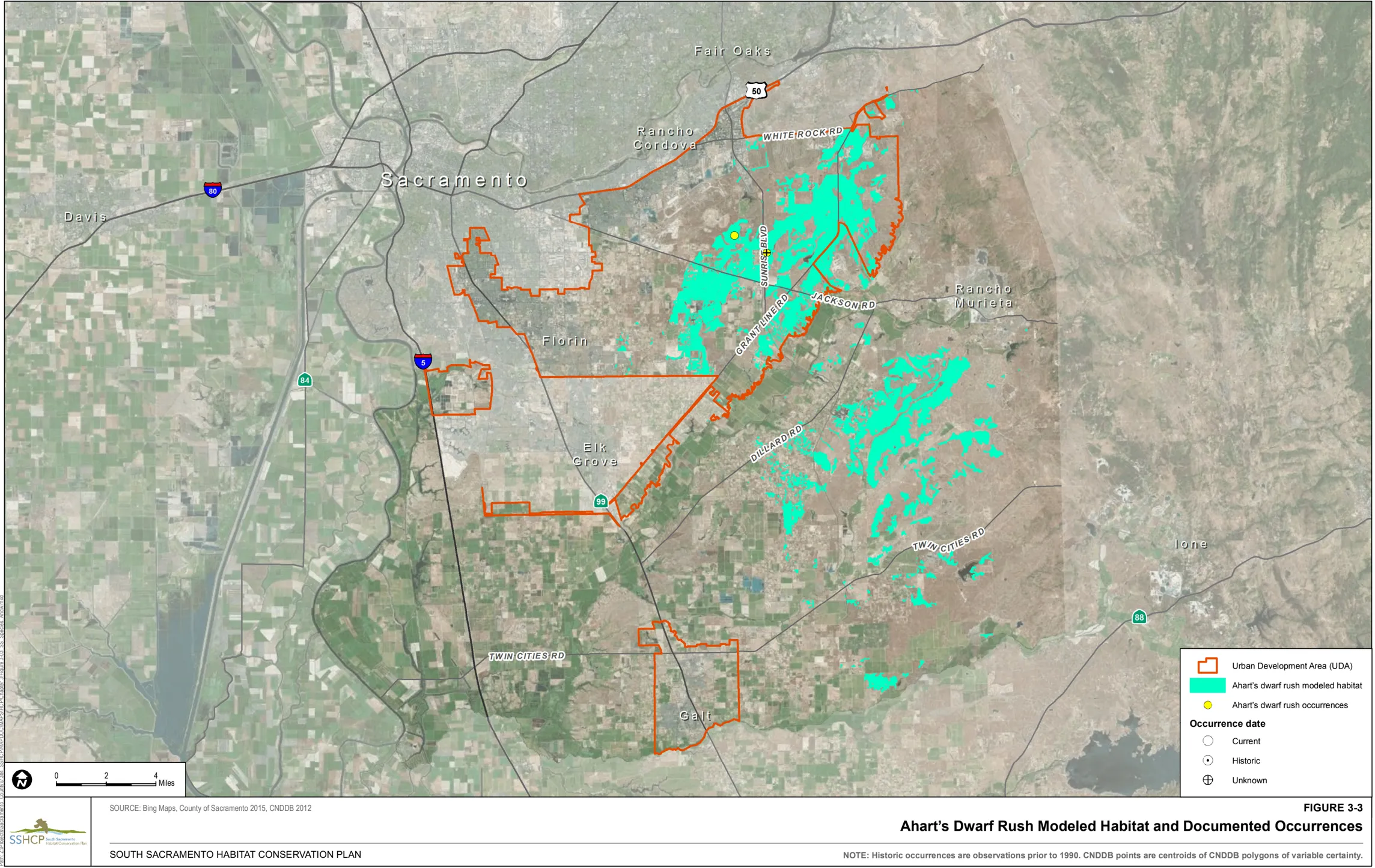
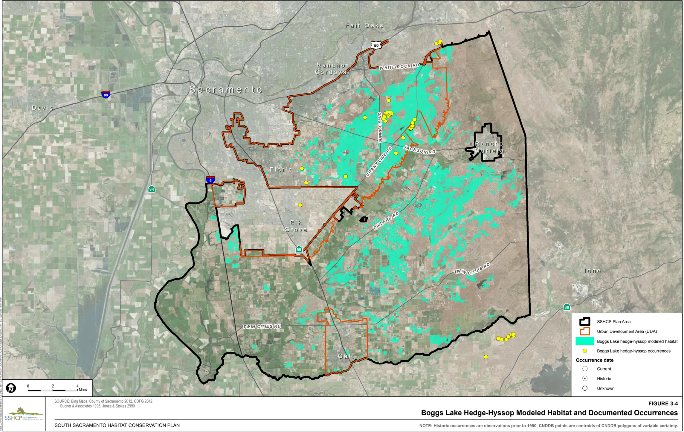
Dwarf Downingia (Downingia pusilla)
Section titled “Dwarf Downingia (Downingia pusilla)”Habitat Requirements
Section titled “Habitat Requirements”Dwarf downingia occurrences are associated mainly with northern claypan vernal pools in central Sacramento County, with northern hardpan vernal pools in the foothills of the Sierra Nevada, and with vernal pools of the Interior Valleys of the Coast Range in Napa and Sonoma Counties (CDFG 2010). Dwarf downingia occupies more commonly occurring, smaller and/or shallower vernal pools with comparatively more ‘flashy’ hydrology (CDFG 2010; Dittes pers. obs., as cited in SSHCP Appendix B). Dwarf downingia also grows along the margins of vernal pools as well as mesic sites within Valley Grassland (CNPS 2010).
Plan Permittee analysis of documented occurrences suggests that in Sacramento County, documented dwarf downingia occurrences are associated with Amador-Gillender complex, Clear Lake clay, Corning complex, Hadselville-Pentz complex, Redding gravelly loam, San Joaquin silt loam, and San Joaquin-Galt complex soil types.
Land Cover Types Relevant to Habitat Requirements
Section titled “Land Cover Types Relevant to Habitat Requirements”SSHCP land cover types that provide suitable habitat based on life history descriptions are Vernal Pool and Swale. Vernal pools are their primary habitat in the Plan Area. Swales may also provide suitable habitat as dwarf downingia prefers short periods of inundation (Table 3-2). Because Vernal Pools and Swales are dependent on surrounding uplands, the Valley Grassland land cover type is also considered suitable habitat for this species.
Occurrences within the Plan Area
Section titled “Occurrences within the Plan Area”There are 10 documented occurrences of dwarf downingia within the Plan Area. All occurrences are outside of the UDA, with eight occurrences in PPU 6 and two occurrences in PPU 7.
Model Assumptions
Section titled “Model Assumptions”- Soil types known to support dwarf downingia in the Plan Area include Amador-Gillender complex, 2% to 15% slopes; Clear Lake clay, partially drained, 0 to 2% slopes, frequently flooded; Corning complex, 0 to 8% slopes; Hadselville-Pentz complex, 2% to 30% slopes; Redding gravelly loam, 0 to 8% slopes; San Joaquin silt loam, 0 to 3% slopes; and San Joaquin-Galt complex, 0 to 3% slopes.
- Dwarf downingia is known to occupy commonly occurring, smaller and/or shallower vernal pools but has also been found at the margins of larger or deeper vernal pools.
- Valley Grasslands are necessary to support the Vernal Pool and Swale land cover types that dwarf downingia occupies.
Dwarf Downingia Modeled Habitat:
Section titled “Dwarf Downingia Modeled Habitat:”Modeled habitat for dwarf downingia is considered to be all Vernal Pool, Swale, and Valley Grassland land cover on Amador-Gillender complex, 2% to 15% slopes; Clear Lake clay, partially drained, 0 to 2% slopes, frequently flooded; Corning complex, 0 to 8% slopes; Durixeralfs-Galt complex, 0 to 2% slopes; San Joaquin silt loam, 0 to 3% slopes; and San Joaquin-Galt complex, 0 to 3% slopes.
Figure 3-5 illustrates the location of modeled habitat as well as documented occurrences of dwarf downingia within the Plan Area.
Legenere (Legenere limosa)
Section titled “Legenere (Legenere limosa)”Habitat Requirements
Section titled “Habitat Requirements”Legenere grows in well-developed vernal pools and playa lakes, as well as along the seasonally fluctuating margins of more permanent water bodies (small lakes, ponds, stock ponds), and basins within seasonal drainages (CDFG 2010; Holland 1983). Topographical position within pools and associated plant species indicate tolerance of, or preference for, the more extreme (longer-duration) inundation regimes encountered in vernal wetlands (Dittes and Guardino, as cited in SSHCP Appendix B).
Plan Permittee analysis of documented occurrences suggests that in Sacramento County, legenere documented occurrences are associated with Clear Lake clay, Corning complex, Creviscreek sandy loam, Dierssen sandy clay loam, Dierssen clay loam, Fiddyment fine sandy loam, Hadselville-Pentz complex, Hedge loam, Hicksville loam, Hicksville gravelly loam, Liveoak sandy clay loam, Madera loam, Natomas loam, Red Bluff loam, Red Bluff-Redding complex, Redding gravelly loam, San Joaquin silt loam, San Joaquin-Galt complex, Xerorthents, and dredge tailings.
Land Cover Types Relevant to Habitat Requirements
Section titled “Land Cover Types Relevant to Habitat Requirements”SSHCP land cover types that provide suitable habitat based on life history descriptions are Vernal Pool and Seasonal Wetland (Table 3-2). Because Vernal Pools and Seasonal Wetlands are dependent on surrounding uplands, the Valley Grassland land cover type is also considered suitable habitat for this species.
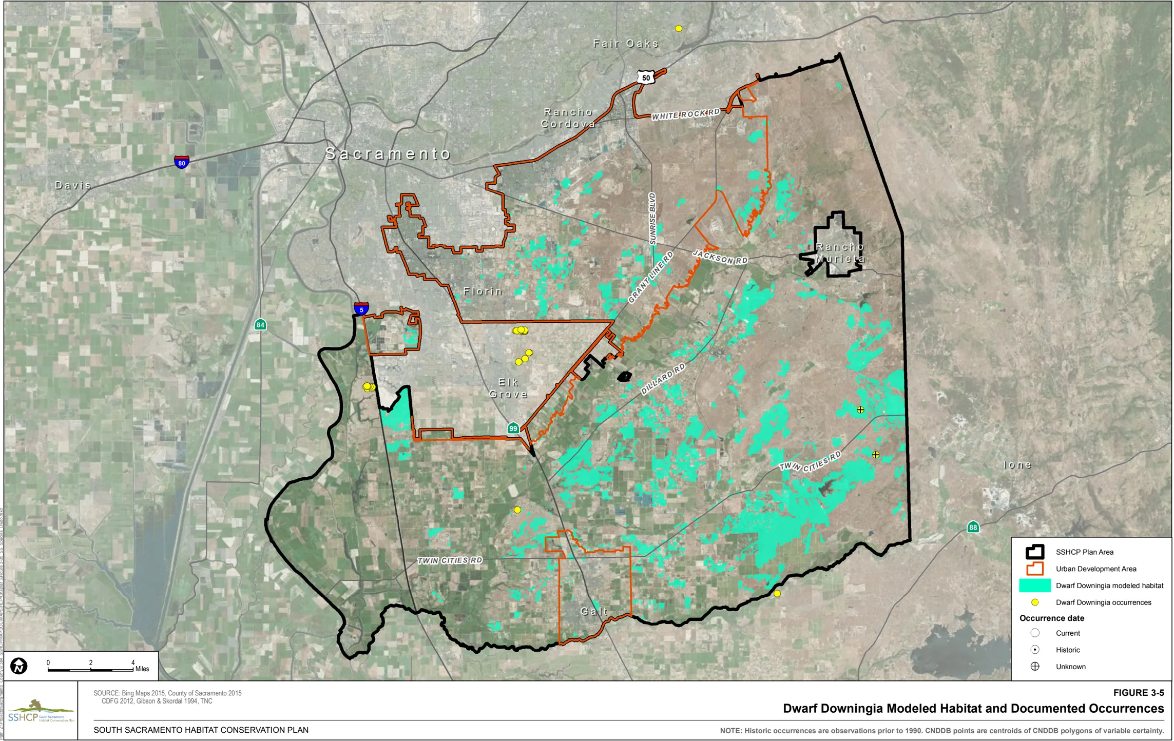
Occurrences within the Plan Area
Section titled “Occurrences within the Plan Area”There are 62 documented occurrences of legenere in the Plan Area. Thirty-six are located within the UDA including 20 within PPU 1, seven in PPU 2, seven in PPU 3, one in PPU 4 and one is not within a PPU. There are 26 occurrences outside of the UDA, including 1 in PPU 5, 16 in PPU 6, and 9 in PPU 7.
Model Assumptions
Section titled “Model Assumptions”- Soil types at documented legenere occurrences in the Plan Area include Clear Lake clay, partially drained, 0 to 2% slopes, frequently flooded; Corning complex, 0 to 8% slopes; Creviscreek sandy loam, 0 to 3% slopes; Dierssen sandy clay loam, drained, 0 to 2% slopes; Fiddyment fine sandy loam, 1% to 8% slopes; Hedge loam, 0 to 2% slopes; Madera-Galt complex, 0 to 2% slopes; Red Bluff loam, 0 to 2% slopes; Red Bluff loam, 2% to 5% slopes; Red Bluff-Redding complex, 0 to 5% slopes; Redding gravelly loam, 0 to 8% slopes; San Joaquin silt loam, 0 to 3% slopes; and San Joaquin-Galt complex, 0 to 3% slopes.
- Legenere grows in well-developed vernal pools, as well as along the seasonally fluctuating margins of more permanent water bodies and basins within seasonal drainages (Holland 1983; CDFG 2010).
- Legenere has been reported to inhabit vernal wetlands ranging in size from 40 square feet to 100 acres (Holland 1983).
- Valley Grasslands are necessary to support the Vernal Pool and Seasonal Wetland land cover types that legenere occupies.
Legenere Modeled Habitat
Section titled “Legenere Modeled Habitat”Modeled habitat for legenere is considered to be all Vernal Pool, Seasonal Wetland, and Valley Grassland land cover types on Clear Lake clay, partially drained, 0 to 2% slopes; frequently flooded, Corning complex, 0 to 8% slopes; Creviscreek sandy loam, 0 to 3% slopes; Dierssen sandy clay loam, drained, 0 to 2% slopes; Fiddyment fine sandy loam, 1 to 8% slopes; Hedge loam, 0 to 2% slopes; Madera-Galt complex, 0 to 2% slopes; Red Bluff loam, 0 to 2% slopes; Red Bluff loam, 2% to 5% slopes; Red Bluff-Redding complex, 0 to 5% slopes; Redding gravelly loam, 0 to 8% slopes; San Joaquin silt loam, 0 to 3% slopes; and San Joaquin-Galt complex, 0 to 3% slopes.
Figure 3-6 illustrates the location of modeled habitat as well as documented occurrences of legenere within the Plan Area.
Pincushion Navarretia (Navarretia myersii)
Section titled “Pincushion Navarretia (Navarretia myersii)”Habitat Requirements
Section titled “Habitat Requirements”Pincushion navarretia is a strict vernal pool endemic. Pincushion navarretia occupies more commonly occurring, smaller and/or shallower vernal pools with comparatively more ‘flashy’ hydrology (Dittes and Guardino, as cited in SSHCP Appendix B).
Plan Permittee analysis of documented occurrences suggests that in Sacramento County, documented pincushion navarretia occurrences are associated with Amador-Gillender complex, Corning complex, Corning-Redding complex, Creviscreek sandy loam, Hadselville-Pentz complex, Hicksville sandy clay loam, Pardee-Rancho Seco complex, Pentz-Lithic Xerorthents complex, and Redding gravelly loam soil types.
Land Cover Types Relevant to Habitat Requirements
Section titled “Land Cover Types Relevant to Habitat Requirements”SSHCP land cover types that provide suitable habitat based on life history descriptions are Vernal Pool and Swale. Vernal pools are their primary habitat in the Plan Area. Swales may also provide suitable habitat as pincushion navarretia appears to prefer short inundation periods (Table 3-2). Because Vernal Pools and Swales are dependent on surrounding uplands, the Valley Grassland land cover type is also considered suitable habitat for this species.
Occurrences within the Plan Area
Section titled “Occurrences within the Plan Area”There are 48 documented occurrences of pincushion navarretia in the Plan Area. All 48 occurrences are located in PPU 7 outside of the UDA.
Model Assumptions
Section titled “Model Assumptions”- Soil types known to support pincushion navarretia occurrences in the Plan Area include Amador-Gillender complex, 2% to 15% slopes; Corning complex, 0 to 8% slopes; Corning-Redding complex, 8 to 30% slopes; Creviscreek sandy loam, 0 to 3% slopes; Hadselville-Pentz complex, 2% to 30% slopes; Hicksville sandy clay loam, 0 to 2% slopes; occasionally flooded, Pardee-Rancho Seco complex, 3% to 15% slopes; PentzLithic Xerorthents complex, 30% to 50% slopes; Peters clay, 1% to 8% slopes; and Redding gravelly loam, 0 to 8% slopes.
- Pincushion navarretia occupies small to medium size vernal pool types and the margins of larger and/or deeper pools.
- Valley Grasslands are necessary to support the Vernal Pool and Swale land cover types that pincushion navarretia occupies.
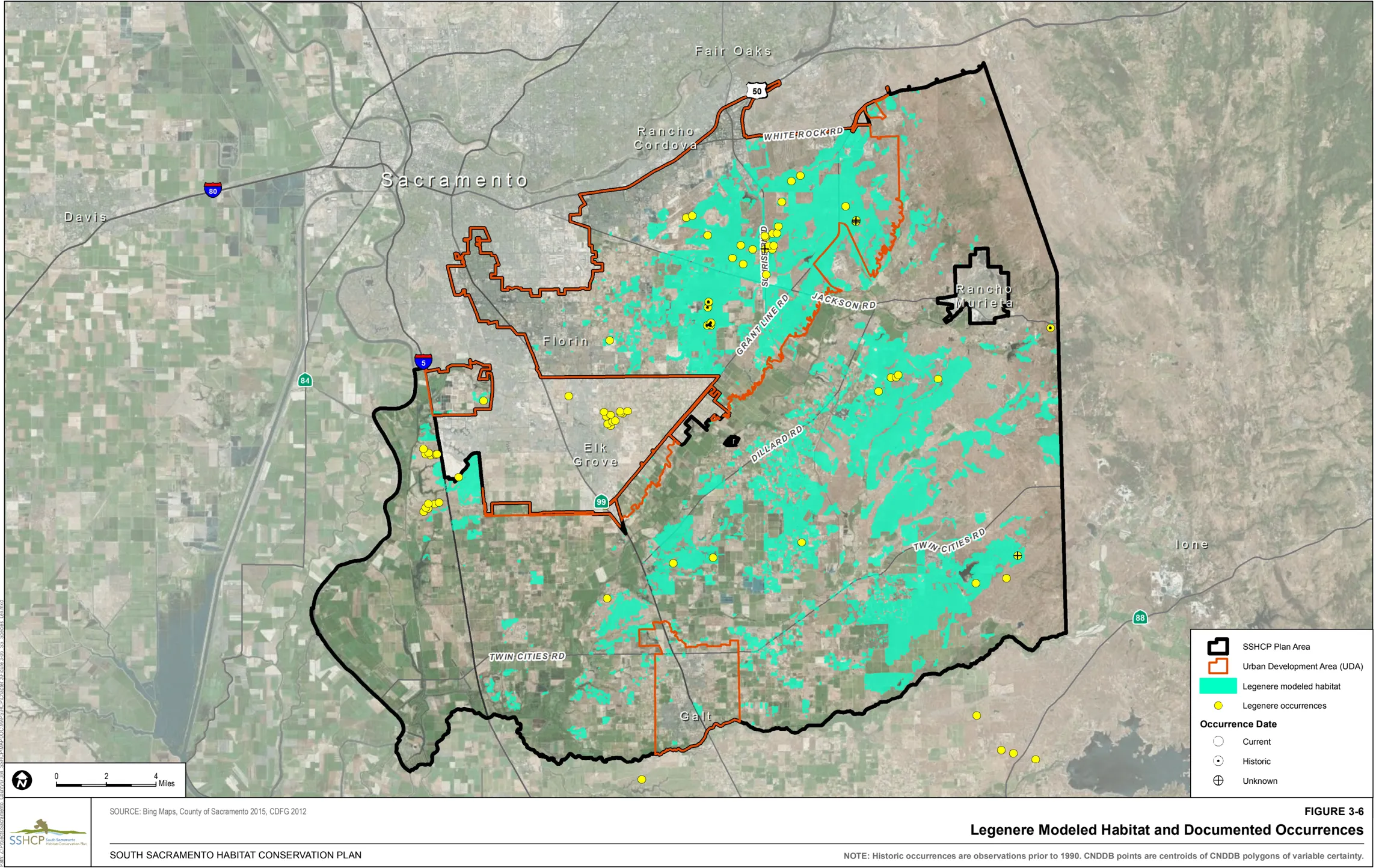
Pincushion Navarretia Modeled Habitat
Section titled “Pincushion Navarretia Modeled Habitat”Modeled habitat for pincushion navarretia is considered to be all Vernal Pool, Swale, and Valley Grassland land cover types on Amador-Gillender complex, 2% to 15% slopes; Corning complex, 0 to 8% slopes; Corning-Redding complex, 8% to 30% slopes; Creviscreek sandy loam, 0 to 3% slopes; Hadselville-Pentz complex, 2% to 30% slopes; Hicksville sandy clay loam 0 to 2% slopes; Pardee-Ranchoseco complex, 3% to 15% slopes; Pentz-Lithic Xerorthents complex, 30% to 50% slopes; and Redding gravelly loam, 0 to 8% slopes.
Figure 3-7 illustrates the location of modeled habitat as well as documented occurrences of pincushion navarretia within the Plan Area.
Sacramento Orcutt Grass (Orcuttia viscida)
Section titled “Sacramento Orcutt Grass (Orcuttia viscida)”Habitat Requirements
Section titled “Habitat Requirements”Sacramento Orcutt grass is a strict vernal pool endemic. Sacramento Orcutt grass appears to be the most specific of the genus Orcuttia with regard to niche breadth, as indicated by restriction to the largest of pools (Stone et al. 1988).
Plan Permittee analysis of documented occurrences suggests that in Sacramento County, Sacramento Orcutt grass is associated with Corning complex; Hicksville sandy clay loam; Red Bluff-Redding complex; and Redding gravelly loam soil types.
Land Cover Types Relevant to Habitat Requirements
Section titled “Land Cover Types Relevant to Habitat Requirements”The SSHCP land cover type that provides suitable habitat based on life history descriptions is vernal pool (Table 3-2). Because Vernal Pools are dependent on surrounding uplands, the Valley Grassland land cover type is also considered suitable habitat for this species.
Occurrences within the Plan Area
Section titled “Occurrences within the Plan Area”There are 40 documented occurrences of Sacramento Orcutt grass within the Plan Area. Of the 40 documented occurrences in the Plan Area, 10 are located within the UDA, including 8 within PPU 1 and 2 within PPU 3. Thirty are outside of the UDA, including 28 within PPU 1 and two within PPU 7.
Model Assumptions
Section titled “Model Assumptions”- Soil types known to support Sacramento Orcutt grass occurrences in the Plan Area include Corning complex, 0 to 8% slopes; Hicksville sandy clay loam, 0 to 2% slopes; Red BluffRedding complex, 0 to 5% slopes; and Redding gravelly loam, 0 to 8% slopes soil types.
- Sacramento Orcutt grass occupies medium to large size vernal pool types.
- Valley Grasslands are necessary to support the Vernal Pools that Sacramento Orcutt grass occupies.
Sacramento Orcutt Grass Modeled Habitat
Section titled “Sacramento Orcutt Grass Modeled Habitat”Modeled habitat for Sacramento Orcutt grass is considered to be all Vernal Pools and Valley Grassland land cover types on Corning complex, 0 to 8% slopes; Hicksville sandy clay loam, 0 to 2% slopes; Red Bluff-Redding complex, 0 to 5% slopes; and Redding gravelly loam, 0 to 8% slopes soil types.
Figure 3-8 illustrates the location of modeled habitat as well as documented occurrences of Sacramento Orcutt grass within the Plan Area.
Slender Orcutt Grass (Orcuttia tenuis)
Section titled “Slender Orcutt Grass (Orcuttia tenuis)”Habitat Requirements
Section titled “Habitat Requirements”Slender Orcutt grass is a strict vernal pool endemic. It is strongly adapted to the hydrologic cycles encountered in the deeper spectrum of vernal pool types, e.g., they are typically associated with larger or deeper vernal pools that tend to possess more extreme regimes of inundation (Crampton 1959; Griggs 1974).
Plan Permittee analysis of documented occurrences suggests that in Sacramento County, documented occurrences of slender Orcutt grass are associated with Redding gravelly loam soil types.
Land Cover Types Relevant to Habitat Requirements
Section titled “Land Cover Types Relevant to Habitat Requirements”The SSHCP land cover type that provides suitable habitat based on life history descriptions is vernal pool (Table 3-2). Because Vernal Pools are dependent on surrounding uplands, the Valley Grassland land cover type is also considered suitable habitat for this species.
Occurrences within the Plan Area
Section titled “Occurrences within the Plan Area”There are four documented occurrences of slender Orcutt grass within the Plan Area. All four occurrences are in the UDA with one in PPU 1 and three in PPU 3.
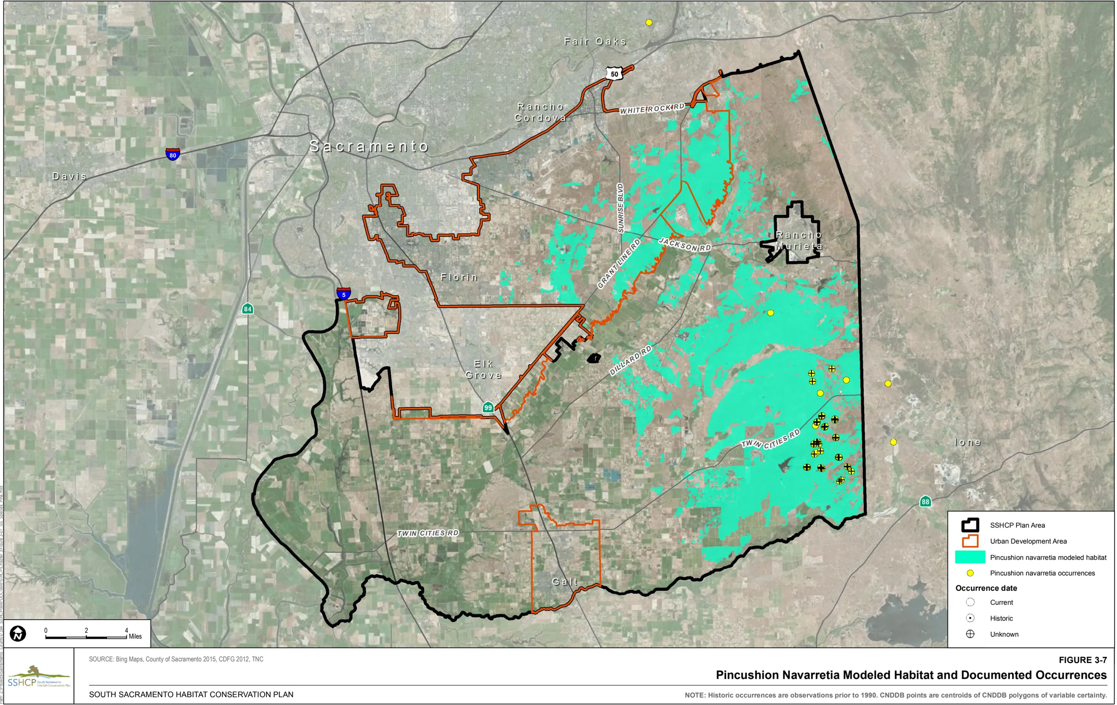
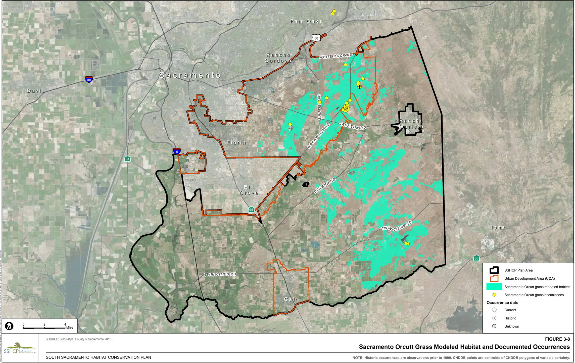
Model Assumptions
Section titled “Model Assumptions”- Soil types known to support slender Orcutt grass in the Plan Area include Redding gravelly loam, 0 to 8% slopes.
- Slender Orcutt grass occupies medium to large size vernal pool types.
- Valley Grasslands are necessary to support the Vernal Pools that slender Orcutt grass occupies.
Slender Orcutt Grass Modeled Habitat
Section titled “Slender Orcutt Grass Modeled Habitat”Modeled habitat for slender Orcutt grass is all Vernal Pool and Valley Grassland land cover types on Redding gravelly loam, 0 to 8% slopes.
Figure 3-9 illustrates the location of modeled habitat as well as documented occurrences of slender Orcutt grass within the Plan Area.
Sanford’s Arrowhead (Sagittaria sanfordi)
Section titled “Sanford’s Arrowhead (Sagittaria sanfordi)”Habitat Requirements
Section titled “Habitat Requirements”Sanford’s arrowhead is associated with freshwater wetland hydrology. This includes emergent wetlands as well as the margins of rivers, streams, ponds, reservoirs, irrigation and drainage canals and ditches, and stock-ponds. Sanford’s arrowhead is occasionally reported to occur in Seasonal Wetland with sufficient ponding period to support emergent wetland species. All freshwater emergent wetlands, natural, modified, and built/created, regardless of landform association, should be considered potentially suitable habitat for Sanford’s arrowhead.
Land Cover Types Relevant to Habitat Requirements
Section titled “Land Cover Types Relevant to Habitat Requirements”SSHCP land cover types that provide suitable habitat based on life history descriptions are Seasonal Wetland, Freshwater Marsh, Open Water, and Stream/Creek (Table 3-2). Because Seasonal Wetland, Freshwater Marsh, Open Water, and Stream/Creek land cover types are dependent on surrounding uplands, the Valley Grassland land cover type is also considered suitable habitat for this species.
Occurrences within the Plan Area
Section titled “Occurrences within the Plan Area”There are 64 documented occurrences of Sanford’s arrowhead in the Plan Area. Fifteen occurrences are located in the UDA with three in PPU 2, two in PPU 3, one in PPU 4, and nine that are not within a PPU. Forty-nine occurrences are located outside of the UDA with three in PPU 5, 42 in PPU 6, three in PPU 7, and one that is not within a PPU.
Model Assumptions
Section titled “Model Assumptions”- Soil types known to support Sanford’s arrowhead in the Plan Area include ArgonautAuburn complex, 3% to 8% slopes; Clear Lake clay, partially drained, 0 to 2% slopes frequently flooded; Columbia sandy loam, partially drained, 0 to 2% slopes; Columbia sandy loam, drained, 0 to 2% slopes, occasionally flooded; Cosumnes silt loam, drained, 0 to 2% slopes, occasionally flooded; Creviscreek sandy loam, 0 to 3% slopes; Dierssen sandy clay loam, drained, 0 to 2% slopes; Dierssen clay loam, deep, drained, 0 to 2% slopes; Durixeralfs, 0 to 1% slopes; Egbert clay, partially drained, 0 to 2% slopes; Egbert clay, partially drained, 0 to 2% slopes, frequently flooded; Fiddyment fine sandy loam, 1% to 8% slopes; Fluvaquents, 0 to 2% slopes, frequently flooded; Hedge loam, 0 to 2% slopes; Hicksville loam, 0 to 2% slopes, occasionally flooded; Hicksville gravelly loam, 0 to 2% slopes, occasionally flooded; Kimball-Urban land complex, 0 to 2% slopes; Liveoak sandy clay loam, 0 to 2% slopes, occasionally flooded; Madera loam, 2% to 8% slopes; Mokelumne-Pits mine complex, 15% to 50% slopes; Red Bluff-Redding complex, 0 to 5% slopes; Redding loam, 2% to 8% slopes; Redding gravelly loam, 0 to 8% slopes; San Joaquin silt loam, leveled, 0 to 1% slopes; San Joaquin silt loam, 0 to 3% slopes; San Joaquin silt loam, 3% to 8% slopes; San Joaquin-Galt complex, leveled, 0 to 1% slopes; San Joaquin-Urban land complex, 0 to 2% slopes; San Joaquin-Xerarents complex, leveled, 0 to 1% slopes; Reiff fine sandy loam, 0 to 2% slopes, occasionally flooded; Scribner clay loam, partially drained, 0 to 2% slopes; and Tinnin loamy sand, 0 to 2% slopes.
- Sanford’s arrowhead is strictly associated with wetland systems supporting emergent marsh vegetation, both naturally occurring and built/created.
- Valley Grasslands are necessary to support the Seasonal Wetland, Freshwater Marsh, Open Water, and Stream/Creek that Sanford’s arrowhead occupies.
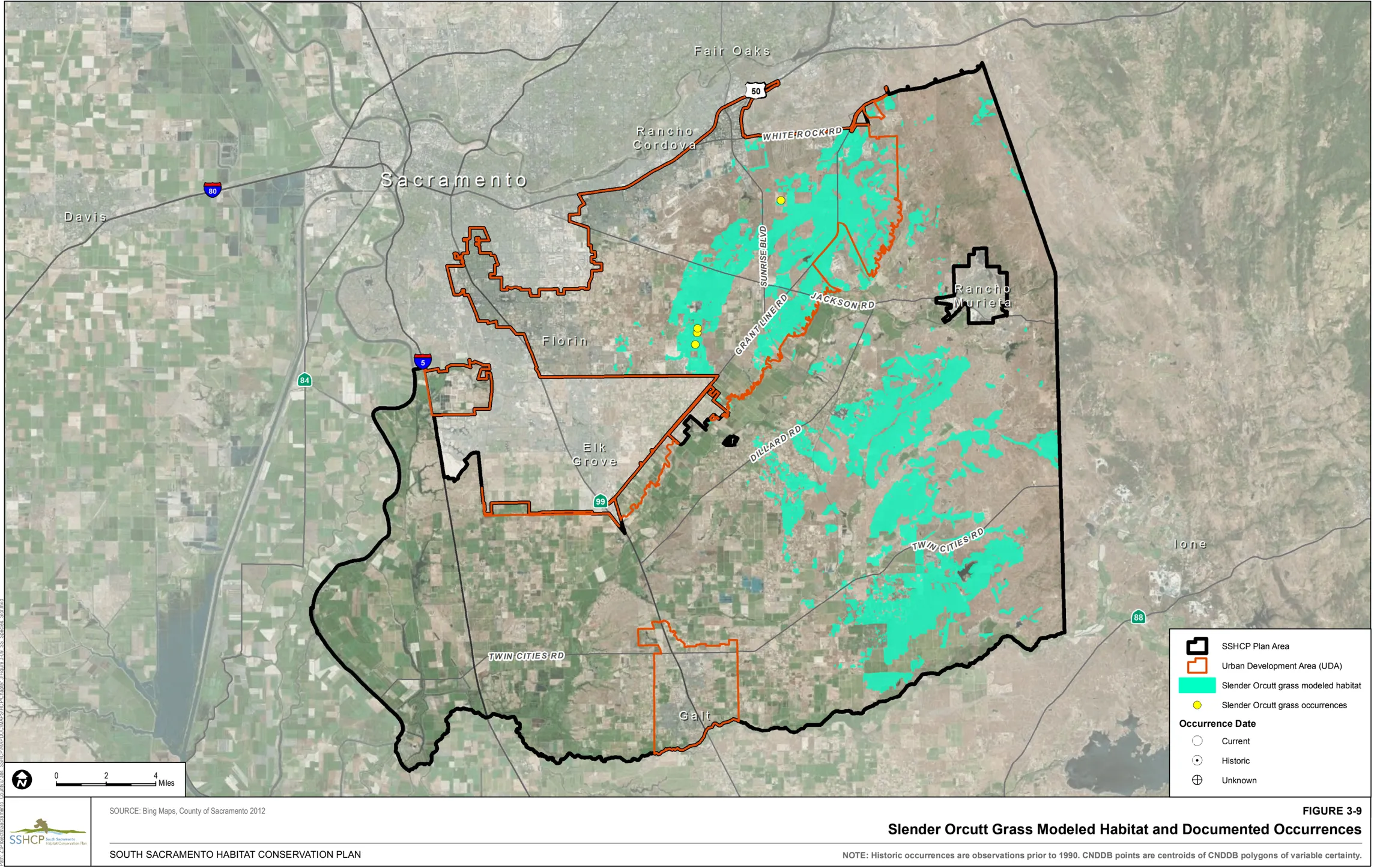
Sanford’s Arrowhead Modeled Habitat
Section titled “Sanford’s Arrowhead Modeled Habitat”Modeled habitat for Sanford’s arrowhead is all Seasonal Wetland, Freshwater Marsh, Open Water, and Stream/Creek associated with Argonaut-Auburn complex, 3% to 8% slopes; Clear Lake clay, partially drained, 0 to 2% slopes frequently flooded; Columbia sandy loam, partially drained, 0 to 2% slopes; Columbia sandy loam, drained, 0 to 2% slopes, occasionally flooded; Cosumnes silt loam, drained, 0 to 2% slopes, occasionally flooded; Creviscreek sandy loam, 0 to 3% slopes; Dierssen sandy clay loam, drained, 0 to 2% slopes; Dierssen clay loam, deep, drained, 0 to 2% slopes; Durixeralfs, 0 to 1% slopes; Egbert clay, partially drained, 0 to 2% slopes; Egbert clay, partially drained, 0 to 2% slopes, frequently flooded; Fiddyment fine sandy loam, 1% to 8% slopes; Fluvaquents, 0 to 2% slopes, frequently flooded; Hedge loam, 0 to 2% slopes; Hicksville loam, 0 to 2% slopes, occasionally flooded; Hicksville gravelly loam, 0 to 2% slopes, occasionally flooded; Kimball-Urban land complex, 0 to 2% slopes; Liveoak sandy clay loam, 0 to 2% slopes, occasionally flooded; Madera loam, 2% to 8% slopes; Mokelumne-Pits mine complex, 15% to 50% slopes; Red Bluff-Redding complex, 0 to 5% slopes; Redding loam, 2% to 8% slopes; Redding gravelly loam, 0 to 8% slopes; San Joaquin silt loam, leveled, 0 to 1% slopes; San Joaquin silt loam, 0 to 3% slopes; San Joaquin silt loam, 3% to 8% slopes; San Joaquin-Galt complex, leveled, 0 to 1% slopes; San Joaquin-Urban land complex, 0 to 2% slopes; San Joaquin-Xerarents complex, leveled, 0 to 1% slopes; Reiff fine sandy loam, 0 to 2% slopes, occasionally flooded; Scribner clay loam, partially drained, 0 to 2% slopes; and Tinnin loamy sand, 0 to 2% slopes.
Figure 3-10 illustrates the location of modeled habitat as well as documented occurrences of Sanford’s arrowhead within the Plan Area.
3.4.2 Invertebrate Covered Species Modeled Habitat
Section titled “3.4.2 Invertebrate Covered Species Modeled Habitat”Mid-Valley Fairy Shrimp (Branchinecta mesovallensis)
Section titled “Mid-Valley Fairy Shrimp (Branchinecta mesovallensis)”Habitat Requirements
Section titled “Habitat Requirements”This small vernal pool crustacean is entirely dependent upon the aquatic environment provided by vernal pool ecosystems. Mid-valley fairy shrimp depends upon the presence of water in the winter and early spring and the absence of water during the summer. These specific vernal pool wetland characteristics are dependent upon the surrounding uplands (Rogers, as cited in SSHCP Appendix B).
Mid-valley fairy shrimp are typically in Central Valley California floristic provinces below 300 meters in elevation. Typical habitat for mid-valley fairy shrimp in California includes vernal pools and seasonally ponded areas within vernal swales (Eng et al. 1990).
Optimal mid-valley fairy shrimp habitat tends to be small vernal pools, with an abbreviated hydroperiod, neutral to slightly alkaline, clear vernal pools, low in dissolved salts, dominated with vernal pool plants, and sustains a complex vernal pool crustacean community (Eriksen and Belk 1999; Rogers 1998).
Land Cover Types Relevant to Habitat Requirements
Section titled “Land Cover Types Relevant to Habitat Requirements”SSHCP land cover types that provide suitable habitat based on life history descriptions include Vernal Pool and Swale. Vernal pools are considered primary habitat in the Plan Area. Swales are considered suitable habitat as they provide connectivity between vernal pool cover types and facilitate the transport of genetic material from one location to another (Table 3-2). Because Vernal Pools and Swales are dependent on surrounding uplands, the Valley Grassland land cover type is also considered suitable habitat for this species.
Occurrences within the Plan Area
Section titled “Occurrences within the Plan Area”There are 37 documented occurrences of mid-valley fairy shrimp located within the Plan Area. Twenty-two are located within the UDA including 10 in PPU 2, 9 in PPU 3, 2 in PPU 8, and 1 that is not within a PPU. Fifteen are located outside of the UDA, including nine in PPU 6 and six within PPU 7.
Model Assumptions
Section titled “Model Assumptions”- Soil types known to support mid-valley fairy shrimp in the Plan Area include Bruella sandy loam, 0 to 2% slopes; Capay clay loam, 0 to 2% slopes, occasionally flooded; Clear Lake clay, hardpan substratum, drained, 0 to 1% slopes; Clear Lake clay, partially drained, 0 to 2% slopes; frequently flooded; Creviscreek sandy loam, 0 to 3% slopes; Durixeralfs-Gat complex, 0 to 2% slopes; Durixeralfs, 0 to 1% slopes; Fiddyment fine sandy loam, 1% to 8% slopes; Galt clay, 0 to 2% slopes; Hedge loam, 0 to 2% slopes; Hicksville loam, 0 to 2% slopes occasionally flooded; Kimball-silt loam, 0 to 2% slopes; Madera loam, 0% to 2% slopes; Natomas loam, 0 to 2 percent slopes; Red Bluff-Redding complex, 0 to 5% slopes; Red Bluff-Xerarents complex, 0 to 2% slopes; Red Bluff loam, 0 to 2% slopes; Red Bluff loam, 2 to 5% slopes; Redding gravelly loam, 0 to 8% slopes; Sailboat silt loam, drained, 0 to 2% slopes, occasionally flooded; San Joaquin-Durixeralfs complex, 0 to 1 percent slopes; San Joaquin-Galt complex, 0 to 3% slopes; San Joaquin-Galt complex, leveled, 0 to 1% slopes; San Joaquin-Xerarents complex, leveled, 0 to 1% slopes; San Joaquin silt loam, 0 to 3% slopes; San Joaquin silt loam, 3 to 8% slopes; San Joaquin silt loam, leveled, 0 to 1% slopes; Vleck gravelly loam, 2 to 15% slopes; Xerarents-Redding complex, 0 to 2% slopes; Xerarents-San Joaquin complex, 0 to 1% slopes.
- SSHCP land cover types that provide suitable habitat based on life history descriptions are all Vernal Pool and all Swale land cover.
- Valley Grasslands are necessary to support the Vernal Pool and Swale land cover types that mid-valley fairy shrimp occupies.
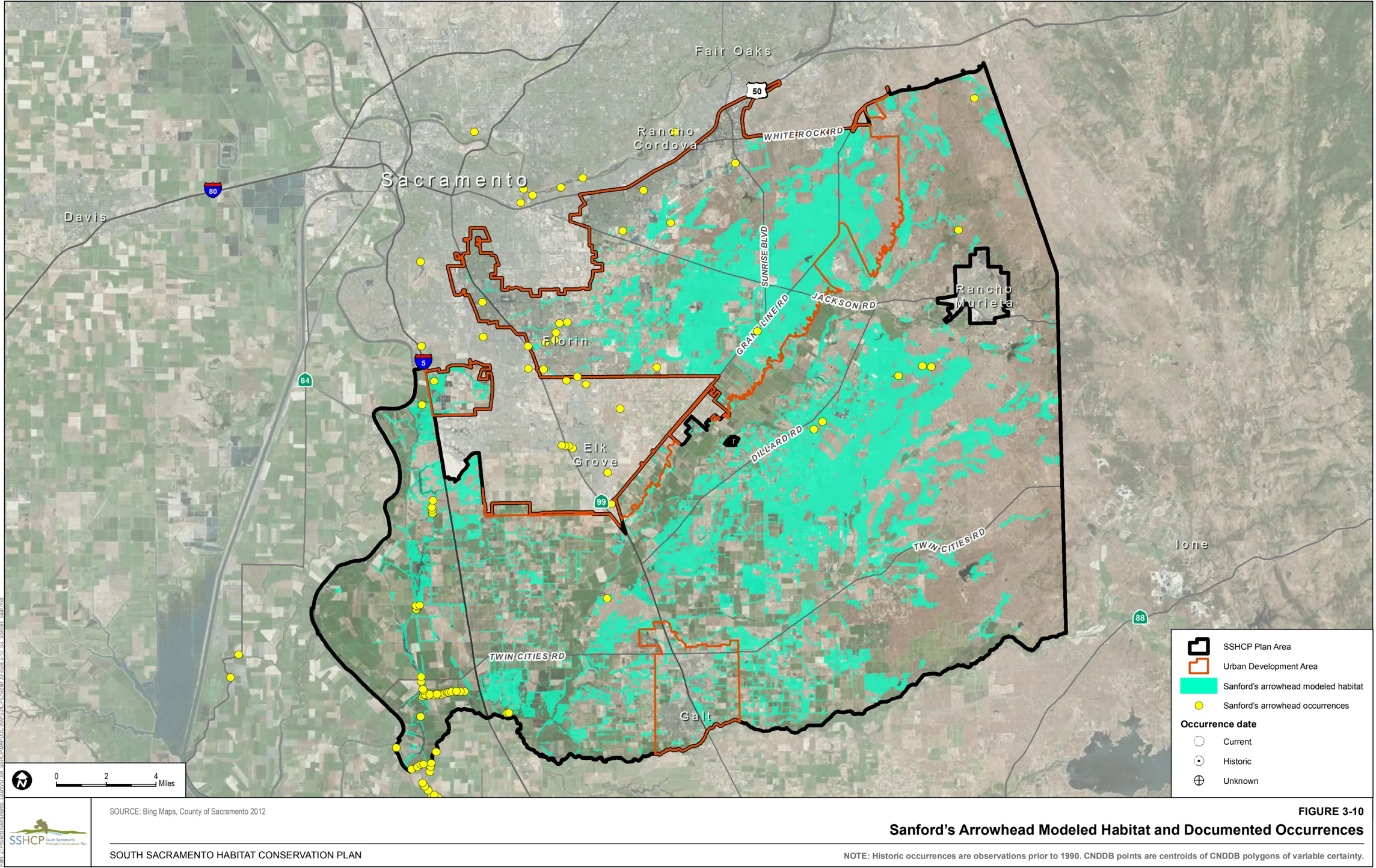
Mid-Valley Fairy Shrimp Modeled Habitat
Section titled “Mid-Valley Fairy Shrimp Modeled Habitat”Modeled habitat for mid-valley fairy shrimp is all Vernal Pool, Swale, and Valley Grassland land cover types associated with Bruella sandy loam, 0 to 2% slopes; Capay clay loam, 0 to 2% slopes, occasionally flooded; Clear Lake clay, hardpan substratum, drained, 0 to 1% slopes; Clear Lake clay, partially drained, 0 to 2% slopes; frequently flooded; Creviscreek sandy loam, 0 to 3% slopes; Durixeralfs-Gat complex, 0 to 2% slopes; Durixeralfs, 0 to 1% slopes; Fiddyment fine sandy loam, 1% to 8% slopes; Galt clay, 0 to 2% slopes; Hedge loam, 0 to 2% slopes; Hicksville loam, 0 to 2% slopes occasionally flooded; Kimball-silt loam, 0 to 2% slopes; Madera loam, 0% to 2% slopes; Natomas loam, 0 to 2 percent slopes; Red Bluff-Redding complex, 0 to 5% slopes; Red Bluff-Xerarents complex, 0 to 2% slopes; Red Bluff loam, 0 to 2% slopes; Red Bluff loam, 2 to 5% slopes; Redding gravelly loam, 0 to 8% slopes; Sailboat silt loam, drained, 0 to 2% slopes, occasionally flooded; San Joaquin-Durixeralfs complex, 0 to 1% slopes; San Joaquin-Galt complex, 0 to 3% slopes; San Joaquin-Galt complex, leveled, 0 to 1% slopes; San Joaquin-Xerarents complex, leveled, 0 to 1% slopes; San Joaquin silt loam, 0 to 3% slopes; San Joaquin silt loam, 3% to 8% slopes; San Joaquin silt loam, leveled, 0 to 1% slopes; Vleck gravelly loam, 2% to 15% slopes; Xerarents-Redding complex, 0 to 2% slopes; Xerarents-San Joaquin complex, 0 to 1% slopes throughout the Plan Area.
Figure 3-11 illustrates the location of modeled habitat as well as the documented occurrences of mid-valley fairy shrimp within the Plan Area.
Ricksecker’s Water Scavenger Beetle (Hydrochara rickseckeri)
Section titled “Ricksecker’s Water Scavenger Beetle (Hydrochara rickseckeri)”Habitat Requirements
Section titled “Habitat Requirements”This vernal pool insect is entirely dependent upon the aquatic environment provided by vernal pool. The Ricksecker’s water scavenger beetle depends upon the presence of water in the winter and early spring and the absence of water during the summer. These specific vernal pool wetland characteristics are dependent upon the surrounding uplands (Rogers, as cited in SSHCP Appendix B).
Vernal pools supporting Ricksecker’s water scavenger beetle are typically in Central Valley California floristic provinces below 300 meters in elevation. Collection records suggest that the Ricksecker’s water scavenger beetle is not sensitive to the size of vernal pools, and uses both vernal pools and swales, as well as constructed vernal pools (Rogers pers. obs., as cited in SSHCP Appendix B).
Optimal Ricksecker’s water scavenger beetle habitat tends to be neutral to slightly alkaline, clear vernal pools, low in dissolved salts, dominated with vernal pool plants, sustaining a complex vernal pool crustacean community (Rogers 1998).
Land Cover Types Relevant to Habitat Requirements
Section titled “Land Cover Types Relevant to Habitat Requirements”SSHCP land cover types that provide suitable habitat, based on life history descriptions are Vernal Pool and Swale land cover types (Table 3-2). Because Vernal Pools and Swales are dependent on surrounding uplands, the Valley Grassland land cover type is also considered suitable habitat for this species.
Occurrences within the Plan Area
Section titled “Occurrences within the Plan Area”There are eight documented occurrences of Ricksecker’s water scavenger beetle in the Plan Area. Four occurrences are located inside the all in PPU 2 and four occurrences are located outside of the UDA including one in PPU 6 and three in PPU 7.
Model Assumptions
Section titled “Model Assumptions”- Ricksecker’s water scavenger beetle is not sensitive to the size of vernal pools or other aquatic habitats (Rogers pers. obs., as cited in SSHCP Appendix B).
- All Vernal Pool and Swale cover types are suitable habitat.
- Valley Grasslands are necessary to support the Vernal Pool and Swale land cover types that Ricksecker’s water scavenger beetle occupies.
Ricksecker’s Water Scavenger Beetle Modeled Habitat
Section titled “Ricksecker’s Water Scavenger Beetle Modeled Habitat”Modeled habitat for Ricksecker’s water scavenger beetle is all Vernal Pool, Swale, and Valley Grassland land cover types within the Plan Area.
Figure 3-12 illustrates the location of modeled habitat as well as the documented occurrences of Ricksecker’s water scavenger beetle within the Plan Area.
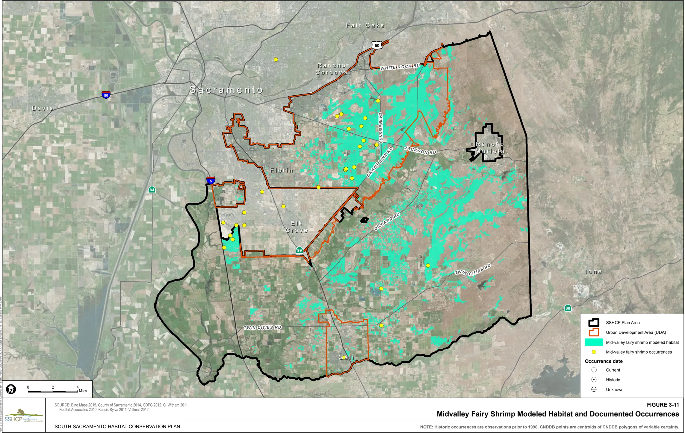
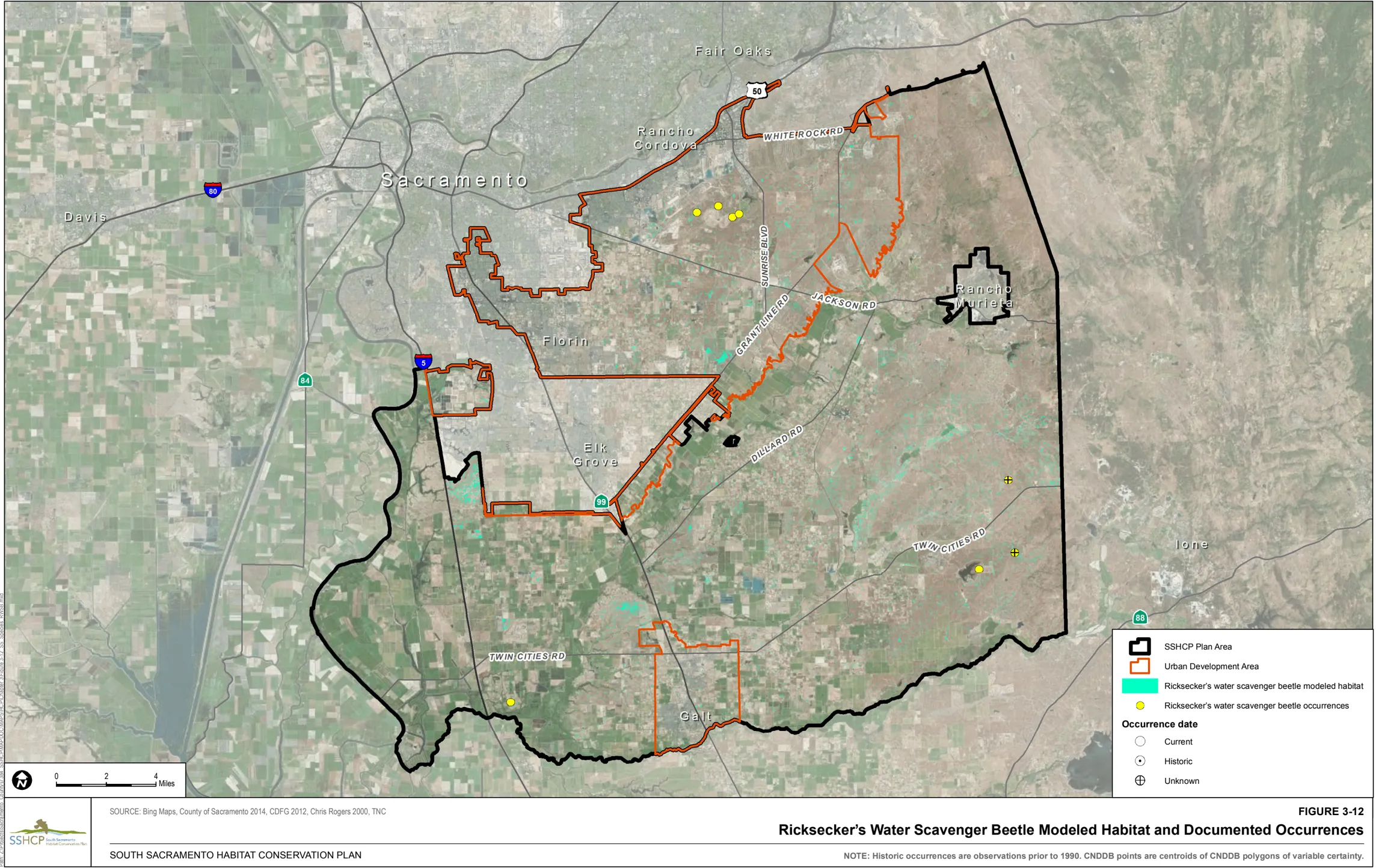
Valley Elderberry Longhorn Beetle (_Desmocerus_californicus_dimorphus )
Section titled “Valley Elderberry Longhorn Beetle (_Desmocerus_californicus_dimorphus )”Habitat Requirements
Section titled “Habitat Requirements”The valley elderberry longhorn beetle is completely dependent upon its host plant, the elderberry shrub, the only recorded larval host plant ( Sambucus glauca, S. mexicana, S. caerulea ) (Barr 1991; Collinge et al. 2001; Eng 1984; Linsley and Chemsak 1972, 1997). Valley elderberry longhorn beetle spends most of its life in the larval stage, living within the stems of the elderberry plant. Adults eat the elderberry foliage until about June when they mate. The females lay eggs in crevices in the bark. Upon hatching, the larvae then begin to tunnel into the elderberry shrub, where they will spend 1 to 2 years eating the interior wood, which is their sole food source. The U.S. Fish and Wildlife Service (USFWS) considers all elderberry shrubs 2.5 centimeters (1 inch) or greater diameter at ground level within the species’ range to be potential habitat (USFWS 1999a). The elderberry shrub is a component of riparian forests throughout the Central Valley. Although this shrub occasionally occurs outside of riparian areas, shrubs supporting the greatest beetle densities are where the shrubs are abundant and interspersed among dense riparian forest (Barr 1991; Collinge et al. 2001; USFWS 1999a). Within the Plan Area elderberry shrubs are commonly found interspersed in Mine Tailing Riparian Woodland cover type, an important cover type for the species.
Land Cover Types Relevant to Habitat Requirements
Section titled “Land Cover Types Relevant to Habitat Requirements”SSHCP land cover types that provide suitable habitat based on life history descriptions are Mine Tailing Riparian Woodland, Mixed Riparian Woodland and Mixed Riparian Scrub (Table 3-2).
Occurrences within the Plan Area
Section titled “Occurrences within the Plan Area”There are 156 documented occurrences of valley elderberry longhorn beetle within the Plan Area. There is one occurrence within the UDA in PPU 1 and 155 occurrences outside the UDA including 154 within PPU 5 and one within PPU 6.
Model Assumptions
Section titled “Model Assumptions”- The valley elderberry longhorn beetle is completely dependent upon the elderberry plant.
- The elderberry and the valley elderberry longhorn beetle are largely found within riparian ecosystems.
- Isolated elderberry shrubs separated from contiguous habitat provide limited habitat value.
Valley Elderberry Longhorn Beetle Modeled Habitat
Section titled “Valley Elderberry Longhorn Beetle Modeled Habitat”Modeled habitat for valley elderberry longhorn beetle is Mine Tailing Riparian Woodland, Mixed Riparian Woodland, and Mixed Riparian Scrub throughout the Plan Area.
Figure 3-13 illustrates the location of modeled habitat as well as the documented occurrences for valley elderberry longhorn beetle within the Plan Area.
Vernal Pool Fairy Shrimp (Branchinecta lynchi)
Section titled “Vernal Pool Fairy Shrimp (Branchinecta lynchi)”Habitat Requirements
Section titled “Habitat Requirements”This small vernal pool crustacean is entirely dependent upon the aquatic environment provided by vernal pool wetland ecosystems. Vernal pool fairy shrimp depends upon the presence of water in the winter and early spring and the absence of water during the summer (Rogers, as cited in SSHCP Appendix B).
Habitats supporting the vernal pool fairy shrimp are typically in Central Valley California floristic provinces below 300 meters elevation. Typical habitat for vernal pool fairy shrimp in California include vernal pools, seasonally ponded areas within vernal swales, rock outcrop ephemeral pools, playas, and alkali flats (Eng et al. 1990). Vernal pool fairy shrimp have also been found in water pooled in sandstone outcrops and in alkaline vernal pools.
Optimal habitat for vernal pool fairy shrimp tends to be neutral to slightly alkaline, clear vernal pools, low in dissolved salts, dominated with vernal pool plants, and sustains a complex vernal pool crustacean community (Eriksen and Belk 1999; Rogers 1998). Fairy shrimp occurs only in cool-water pools. Individuals hatch from cysts during cold-weather winter storms; they require water temperatures of 50 o F or lower to hatch (Eriksen and Belk 1999; Helm 1998). The time to maturity and reproduction is temperature-dependent, varying between 18 days and 147 days, with a mean of 40 days (Helm 1998). Pool volume is also important in determining potential shrimp habitat because deeper pools with a large surface area can more easily maintain their dissolved oxygen levels. Similarly, deeper pools will pond long enough to allow the shrimp to complete their life cycle (Rogers, as cited in SSHCP Appendix B).
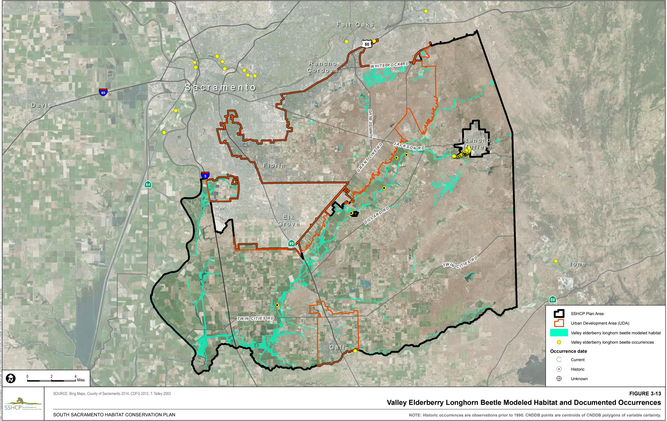
Land Cover Types Relevant to Habitat Requirements
Section titled “Land Cover Types Relevant to Habitat Requirements”SSHCP land cover types that provide suitable habitat based on life history descriptions include Vernal Pool, Swale, and Stream/Creek (VPIH). Vernal pools are the species primary habitat in the Plan Area. Swales and Stream/Creek (VPIH) are considered suitable habitat as they provide connectivity between Vernal Pool cover types and facilitate the transport of genetic material from one location to another (Table 3-2). These specific vernal pool wetland characteristics are dependent on the surrounding uplands. Because Vernal Pools, Swales, and Stream/Creek (VPIH) are dependent on surrounding uplands, the Valley Grassland land cover type is also considered suitable habitat for this species.
Occurrences within the Plan Area
Section titled “Occurrences within the Plan Area”There are 581 documented occurrences of vernal pool fairy shrimp within the Plan Area. There are 193 located within the UDA including 30 in PPU 1, 48 in PPU 2, 95 in PPU 3, four in PPU 4, one in PPU 8, and 15 that are not within a PPU. There are 388 occurrences outside of the UDA including 26 in PPU 1, 11 in PPU 5, 26 in PPU 6, 324 in PPU 7, and one that is not within a PPU.
Model Assumptions
Section titled “Model Assumptions”- Vernal pool fairy shrimp are widely distributed throughout the Plan Area, although they appear to be more abundant outside of the Urban Development Area (UDA) than inside the UDA.
- All Vernal Pool and Swale cover types are suitable habitat.
- A select group of ephemeral steams or portions of those streams in this Plan Area are considered suitable habitat.
- Valley Grasslands are necessary to support the Vernal Pool, Swale, and Stream/Creek (VPIH) land cover types that vernal pool fairy shrimp occupies.
Vernal Pool Fairy Shrimp Modeled Habitat
Section titled “Vernal Pool Fairy Shrimp Modeled Habitat”Modeled habitat for vernal pool fairy shrimp is all vernal Pool, Swale, Stream/Creek (VPIH), and Valley Grassland throughout the Plan Area.
Figure 3-14 illustrates the location of modeled habitat as well as the documented occurrences of vernal pool fairy shrimp within the Plan Area.
Vernal Pool Tadpole Shrimp (Lepidurus packardi)
Section titled “Vernal Pool Tadpole Shrimp (Lepidurus packardi)”Habitat Requirements
Section titled “Habitat Requirements”This small vernal pool crustacean is entirely dependent upon the aquatic environment provided by vernal pool wetland ecosystems. Vernal pool tadpole shrimp depends upon the presence of water in the winter and early spring and the absence of water during the summer. These specific vernal pool wetland characteristics are dependent upon the surrounding uplands.
Habitats supporting the Vernal pool tadpole shrimp are typically in Central Valley California floristic provinces below 300 meters in elevation. Typical habitat for vernal pool tadpole shrimp in California includes vernal pools, seasonally ponded areas within vernal swales, rock outcrop ephemeral pools, playas, and alkali flats (Eriksen and Belk 1999; Rogers 2001). Vernal pool tadpole shrimp have also been found in alkaline vernal pools.
Optimal habitat for vernal pool tadpole shrimp tends to be neutral to slightly alkaline, clear vernal pools, low in dissolved salts, dominated with vernal pool plants, and sustains a complex vernal pool crustacean community (Eriksen and Belk 1999). Pool volume is also important in determining potential shrimp habitat because deeper pools with a large surface area can more easily maintain their dissolved oxygen levels. Similarly, deeper pools will pond long enough to allow the shrimp to complete their life cycle. Occupied pools may have aquatic vegetation that may provide shelter from predators and range in size from 54 square feet to 84 acres (59 Federal Register 48136-48153). Although the tadpole shrimp is found on a variety of geologic formations and soil types, Helm (1998) found that, throughout the range, more than 50% of tadpole shrimp occurrences were on High Terrace, also known as old terrace landforms and Laguna Formation Redding and Corning soils. In the Plan Area, vernal pool tadpole shrimp has been observed in many of the vernal streams in the UDA (Adelsbach, pers. comm. 2013).These are mapped by the Permittees as the ‘Creek/Stream VPIH’ land cover.
Land Cover Types Relevant to Habitat Requirements
Section titled “Land Cover Types Relevant to Habitat Requirements”SSHCP land cover types that provide suitable habitat based on life history descriptions include Vernal Pool, Swale, and Stream/Creek (VPIH). Vernal pools are considered the species primary habitat in the Plan Area. Swale and Stream/Creek (VPIH) land cover types are considered suitable habitat as they provide connectivity between the Vernal Pool land cover type and facilitate the transport of genetic material from one location to another (Table 3-2). These specific Vernal Pool Wetland characteristics are dependent on the surrounding uplands. Because Vernal Pools, Swales, and Stream/Creek (VPIH) are dependent on surrounding uplands, the Valley Grassland land cover type is also considered suitable habitat for this species.
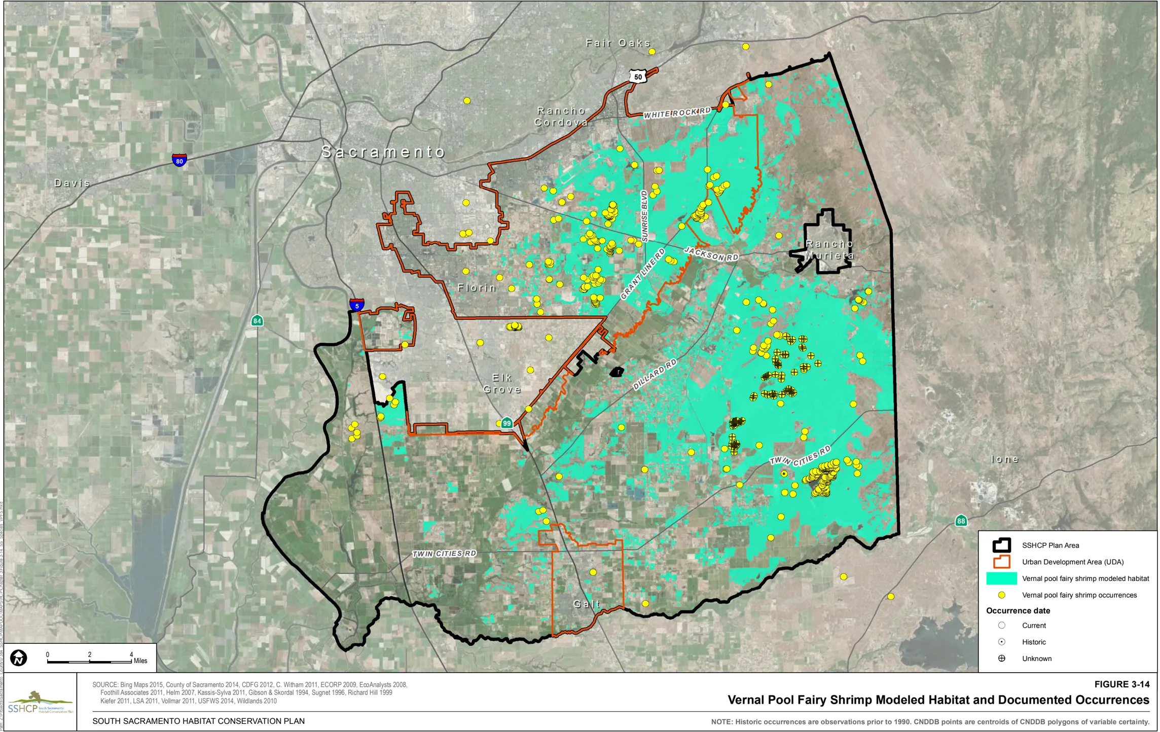
Occurrences within the Plan Area
Section titled “Occurrences within the Plan Area”There are 851 documented occurrences of vernal pool tadpole shrimp within the Plan Area. Of the 851 documented occurrences, 587 are within the UDA including 266 in PPU 1, 145 in PPU 2, 147 in PPU 3, six in PPU 4, four in PPU 8, and 19 that are not within a PPU. There are 264 occurrences outside of the UDA including 42 in PPU 1, 26 in PPU 6, 194 in PPU 7, and two that are not within a PPU.
Model Assumptions
Section titled “Model Assumptions”- Vernal pool tadpole shrimp are widely distributed throughout the Plan Area, although they appear to be more abundant within the Urban Development Area (UDA) than outside the UDA.
- All Vernal Pool, Vernal Stream, and Swale cover types are suitable habitat.
- A select group of ephemeral steams or portions of those streams in the Plan Area are considered suitable habitat (classified as Stream/Creek (VPIH)).
- Valley Grasslands are necessary to support the Vernal Pool, Swale, and Stream/Creek (VPIH) land cover types that vernal pool tadpole shrimp occupies.
Vernal Pool Tadpole Shrimp Modeled Habitat
Section titled “Vernal Pool Tadpole Shrimp Modeled Habitat”Modeled habitat for vernal pool tadpole shrimp is all Vernal Pool, Swale, Stream/Creek (VPIH), and Valley Grassland land cover types throughout the Plan Area.
Figure 3-15 illustrates the location of modeled habitat as well as the documented occurrences of vernal pool tadpole shrimp within the Plan Area.
3.4.3 Amphibians
Section titled “3.4.3 Amphibians”California Tiger Salamander (Ambystoma californiense)
Section titled “California Tiger Salamander (Ambystoma californiense)”Habitat Requirements
Section titled “Habitat Requirements”The upland component of California tiger salamander habitat typically consists of Grassland or Blue Oak Savanna (Shaffer et al. 1993; USFWS 2004a). California tiger salamander spends most of its life cycle underground in grassland habitat, primarily in rodent burrows. Breeding adults comprise approximately 30% of a California tiger salamander population, while approximately 70% consists of juveniles who have not yet reached sexual maturity. These juveniles remain underground in burrows year-round and typically do not return to breeding habitat during the winter. (Searcy, pers. comm. 2012). California tiger salamanders typically use underground burrows constructed by ground squirrels or other fossorial animals in open grassland or under isolated oaks, and less commonly in woodlands (Shaffer et al. 1993). Adults are terrestrial outside of the breeding season, and have been known to inhabit rodent burrows located up to 1.3 miles from breeding ponds.
Once fall or winter rains begin, adult California tiger salamanders emerge from their upland refugia at night to migrate to breeding ponds (Stebbins 1985, 1989; Shaffer et al. 1993). Males remain at the breeding pools on average for 44.7 days and females averaged 11.8 days (Trenham et al. 2000). Historically, vernal pools and other natural seasonal ponds constituted primary breeding sites used by California tiger salamanders (Feaver 1971; Storer 1925; Trenham et al. 2000; Zeiner et al. 1988). In the absence of historical breeding ponds, stock ponds have become important aquatic habitats for the California tiger salamander throughout its range (USFWS 2004a). During this species’ lifetime, individuals from sub-populations could migrate between aquatic and upland habitats, colonizing newly created and geographically isolated ponds provided the intervening habitat could be successfully traversed by dispersing individuals (USFWS 2004a).
Land Cover Types Relevant to Habitat Requirements
Section titled “Land Cover Types Relevant to Habitat Requirements”SSHCP land cover types that provide suitable aquatic habitat based on life history descriptions include Vernal Pool and Seasonal Wetland. Suitable habitat for upland refugia includes Valley Grassland, Blue Oak Woodland, and Blue Oak Savanna (Table 3-2).
Occurrences within the Plan Area
Section titled “Occurrences within the Plan Area”There are 31 documented occurrences of California tiger salamanders in the Plan Area. Two occurrences are located within the UDA in PPU 8 and 29 occurrences are outside of the UDA in PPU 7.
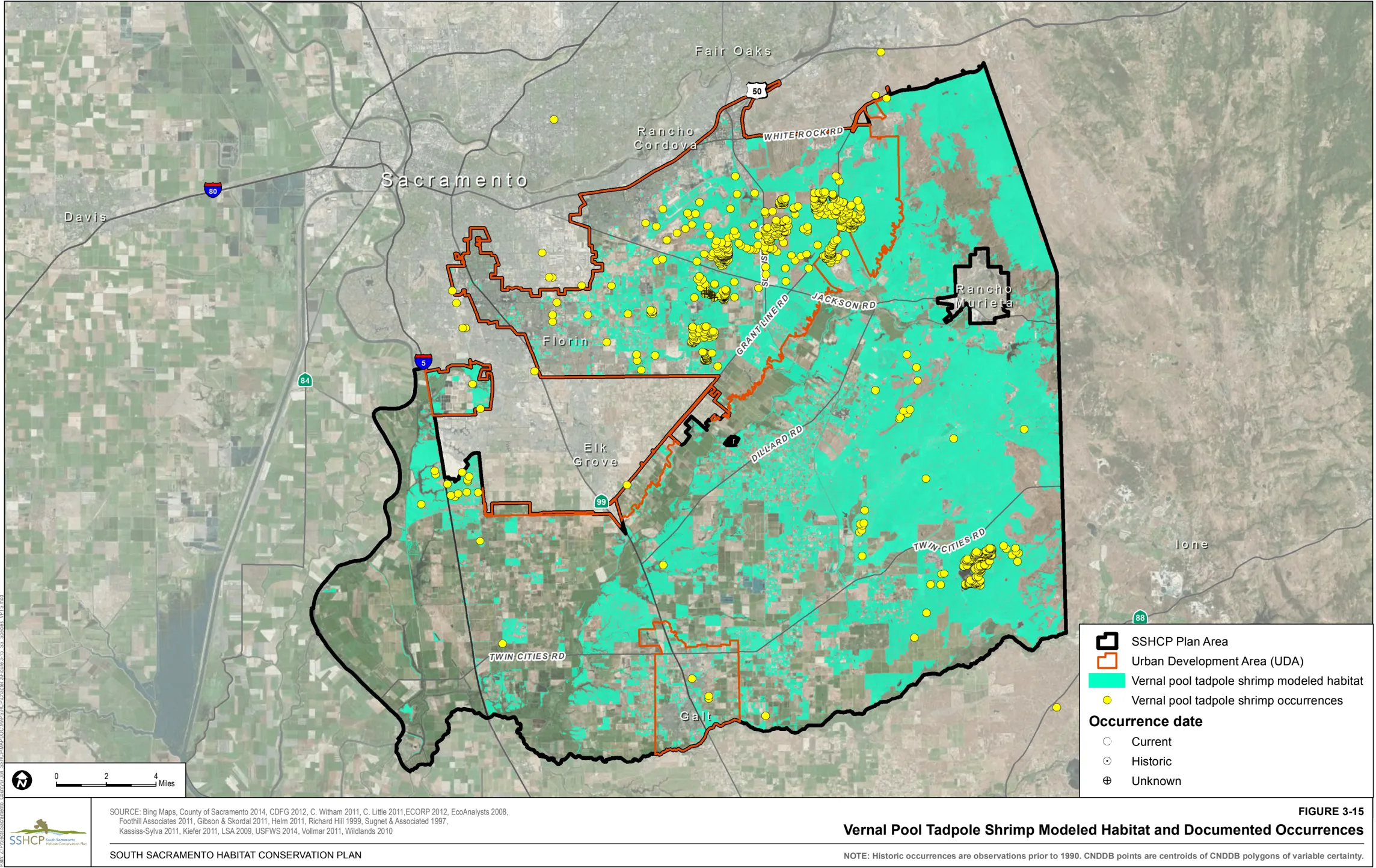
Model Assumptions
Section titled “Model Assumptions”- California tiger salamanders have not been recorded within the Sacramento County Urban Services Boundary or north of the Cosumnes River despite extensive surveys in very large areas with presumably suitable habitat including Mather Field, Sacramento Valley Conservancy’s Vernal Pool Prairie Preserve, the Sunrise Douglas Area, Kiefer landfill, Rancho Murieta, and areas East of Grant Line Road.
- In a 5-year study, Orloff (2011) found the majority of California tiger salamanders migrated at least 0.5 mile (0.8 kilometer) from the breeding site. A smaller number of salamanders appeared to migrate even farther, traveling 0.75 mile (1.2 kilometer) to almost 1.3 miles (2.2 kilometers) to and from the breeding ponds and upland habitat on adjacent property.
- A study by Searcy and Shaffer (2011) found that California tiger salamanders are physiologically capable of migrating up to 2,484 meters (1.5 miles) each breeding season and that 95% of the population occurs in upland habitat within 1,867 meters of the breeding pond.
- Trenham et al. (2001) recommended that plans to maintain local populations of California tiger salamanders should include pond(s) surrounded by at least 173-meter (567-foot) wide buffers of terrestrial habitat occupied by burrowing mammals.
California Tiger Salamander Modeled Habitat
Section titled “California Tiger Salamander Modeled Habitat”Modeled aquatic habitat for California tiger salamander is Vernal Pool and Seasonal Wetland land cover located south of the Cosumnes River. Modeled upland refugia habitat is all Blue Oak Woodland, Blue Oak Savanna, and Valley Grassland land cover located within 1.5 miles of modeled aquatic habitat (i.e., within 1.5 miles of any Vernal Pool or Seasonal Wetland that is south of the Cosumnes River).
Figure 3-16 illustrates the location of modeled habitat as well as the documented occurrences of California tiger salamander within the Plan Area.
Western Spadefoot (Spea hammondii)
Section titled “Western Spadefoot (Spea hammondii)”Habitat Requirements
Section titled “Habitat Requirements”Western spadefoot primarily occurs in lowland habitats generally below 900 meters (3,000 feet) within or adjacent to washes, floodplains of rivers, alluvial fans, playas, and alkali flats. They also occur in the foothills and mountains (Stebbins 1985) up to 1,363 meters (4,500 feet) (Morey 1988). Associated vegetative communities include valley-foothill grassland, open chaparral, pine-oak woodland and lower montane conifer and mixed conifer forest within open areas comprised of short grasses and sandy or gravelly soil. Western spadefoots have two distinct habitat requirements including quiet streams (Stebbins 2003) or seasonal pools for breeding and uplands for foraging and dry-season aestivation. Western spadefoot eggs and larvae have been observed in a variety of permanent and temporary wetlands including rivers, creeks, pools in intermittent streams, vernal pools, and temporary rain pools (CDFG 2010). They have also been found in altered wetlands including vernal pools that have been disturbed by activities such as earthmoving, disking, intensive livestock use, and off-road vehicle use, and created wetlands such as artificial ponds, livestock ponds, sedimentation and flood control ponds, irrigation and roadside ditches, roadside puddles, tire ruts, and borrow pits (Fisher and Shaffer 1996; CDFG 2010). Often undervalued in conservation planning, terrestrial habitats surrounding aquatic breeding sites are critical to the survival of many semiaquatic species that depend on mesic ecotones to complete their life cycles (Semlitsch and Bodie 2003).
Land Cover Types Relevant to Habitat Requirements
Section titled “Land Cover Types Relevant to Habitat Requirements”Suitable aquatic habitat based on life history descriptions includes Vernal Pool, Seasonal Wetland, Swale, Open Water, and Stream/Creek. Suitable habitat for upland foraging includes Blue Oak Woodland, Blue Oak Savanna, and Valley Grassland (Table 3-2).
Occurrences within the Plan Area
Section titled “Occurrences within the Plan Area”There are 41 documented occurrences of western spadefoot in the Plan Area. Twenty occurrences are inside the UDA with seven in PPU 1, 12 in PPU 2, and one in PPU 3. There are 21 occurrences outside of the UDA with two in PPU 5 and 19 in PPU 7.
Model Assumption
Section titled “Model Assumption”- Very little information is available regarding dispersal distances or minimum habitat size.
- Semlitsch and Brodie (2003) summarized data from the literature on the use of terrestrial habitats by 19 frog and 13 salamander species representing 1,363 individuals that are otherwise typically associated with wetlands. In general, plethodontid stream salamanders (e.g., Desmognathus fuscus, Eurycea bislineata, Eurycea longicauda ), although migratory at some stage of their life cycle, remain close to the edges of ponds and streams and seldom move more than 20 to 30 meters from aquatic habitats. Alternatively, some species of frogs, toads and newts are highly mobile and move 1,000 to 1,600 meters (5,249 feet or about 1 mile) (e.g., Bufo bufo, Rana catesbbeiana , Notophthalmus viridescens ). The majority of the remaining species occur at intermediate distances, where they emigrate to find suitable terrestrial habitat. The overall core terrestrial habitat ranged from 159 to 290 meters (522 to 951 feet) from the edge of aquatic breeding sites.
Western Spadefoot Modeled Habitat
Section titled “Western Spadefoot Modeled Habitat”Modeled aquatic habitat for western spadefoot is Vernal Pool, Seasonal Wetland, Swale, Open Water, and Stream/Creek land cover types in the Plan Area. Modeled upland habitat is Blue Oak Woodland, Blue Oak Savanna, and Valley Grassland within 1,600 meters (5,249 feet or approximately 1 mile) from modeled aquatic habitat.
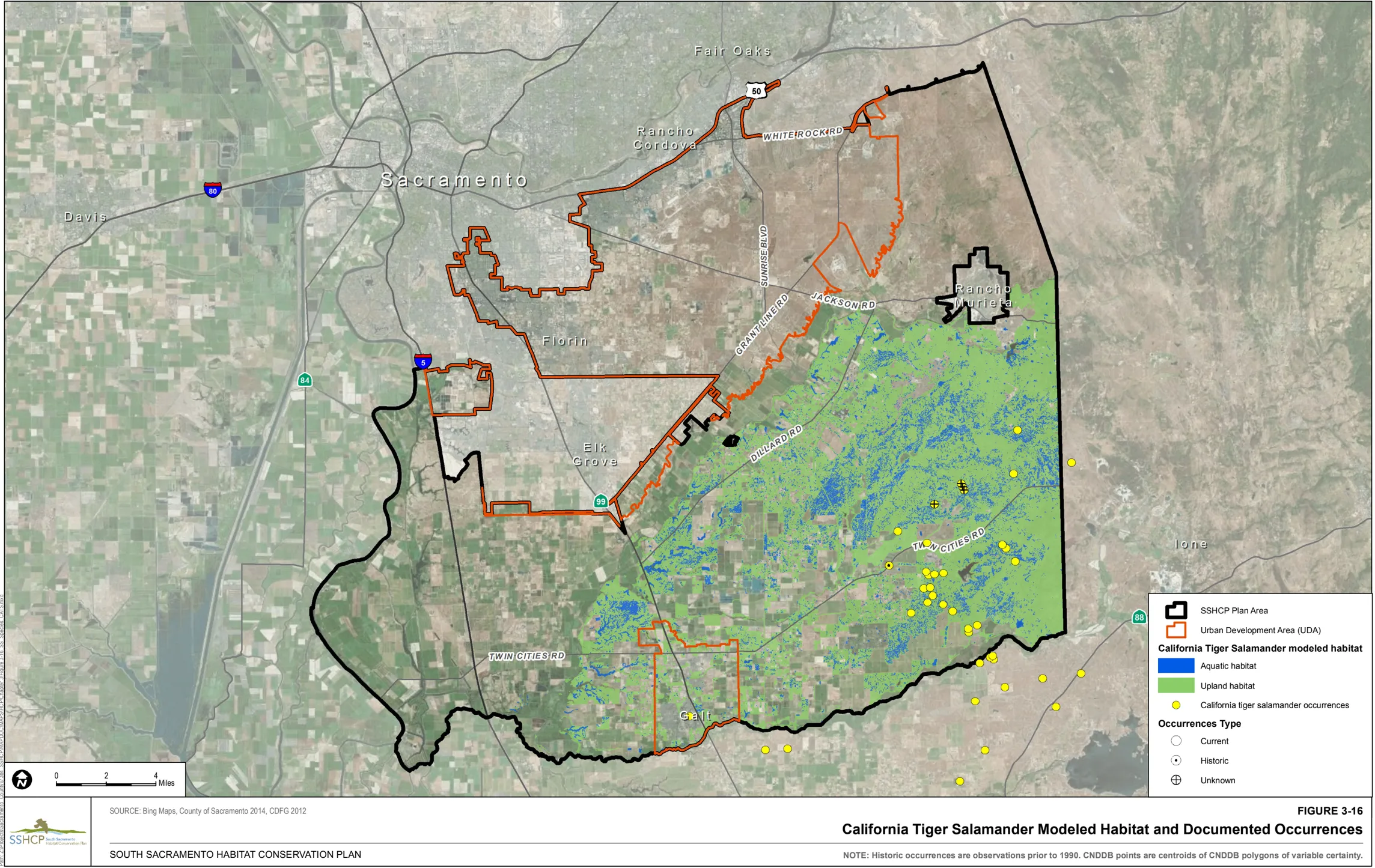
Figure 3-17 illustrates the location of modeled habitat and the documented occurrences of western spadefoot within the Plan Area.
3.4.4 Reptiles
Section titled “3.4.4 Reptiles”Giant Gartersnake (Thamnophis gigas)
Section titled “Giant Gartersnake (Thamnophis gigas)”Habitat Requirements
Section titled “Habitat Requirements”Endemic to valley floor wetlands in California’s Central Valley, the giant gartersnake inhabits marshes, sloughs, low gradient streams, and other waterways and agricultural wetlands such as irrigation and drainage canals and rice fields. Suitable habitat consists of (1) adequate water during the snake’s active season (early spring through mid-fall) to provide food and cover, (2) emergent, herbaceous wetland vegetation, such as Scirpus and Typha spp. for escape cover and foraging habitat during the active season, (3) grassy banks and openings in waterside vegetation for basking, and (4) higher elevation uplands for cover and refuge from flood waters during the snake’s dormant season in the winter (Hansen 1988). Wylie et al. (2010) found that giant garter snakes will persist in areas dominated by rice, by foraging in flooded rice fields after the rice plants have grown sufficiently to provide cover from predators. It appears that giant garter snakes do not tolerate seasonal wetlands managed for waterfowl if there is no aquatic habitat available during the active summer season. A study of Body Condition Index (BCI) and population estimates strongly indicates that perennial marshes provide the highest quality giant garter snake habitat, rice agriculture is acceptable habitat, and seasonal winter wetlands provides the least suitable habitat of the three types (Wylie et al. 2010). Although rice fields are a key habitat for giant garter snakes throughout most of its range, there is no active rice cultivation within the Plan Area. The nearest region of rice production is the Natomas Basin located in northwest Sacramento County. Giant garter snakes are absent from larger rivers and other water bodies that support introduced populations of large, predatory fish, and from wetlands with sand, gravel, or rock substrates (Brode 1988; Hansen 1980; Hansen 1988; Rossman and Stewart 1987). Riparian woodlands do not typically provide suitable habitat because of excessive shade, lack of basking sites, and absence of prey populations (Hansen 1980).
In addition to grassy banks, giant garter snakes will bask in bulrush, cattails, shrubs overhanging the water, patches of waterweed (Ludwigia peploides) and other floating vegetation. In the San Joaquin Valley, giant garter snakes also bask in openings within saltbush ( Atriplex spp.) (Brode 1988; Van Denburgh and Slevin 1918). Riparian vegetation such as saltbush and willows (Salix spp.) provide cover from predation. Giant gartersnakes also bask in openings in vegetation created by rip-rap placed around water control structures. Giant garter snakes use small mammal burrows and other soil crevices above prevailing flood elevations during the winter (i.e., November to mid-March), typically with sunny exposures along south- and west-facing slopes (USFWS 1999b). During the active season, small mammal burrows, crayfish burrows, and soil crevices provide retreats from extreme heat (Hansen and Brode 1993).
Land Cover Types Relevant to Habitat Requirements
Section titled “Land Cover Types Relevant to Habitat Requirements”Suitable aquatic habitat for giant gartersnake based on life history descriptions include Seasonal Wetland, Freshwater Marsh, Open Water, and Stream/Creek. Suitable upland habitat includes Mixed Riparian Scrub and Valley Grassland (Table 3-2).
Occurrences within the Plan Area
Section titled “Occurrences within the Plan Area”There are 14 documented occurrences of giant gartersnake within the Plan Area. Two occurrences are within the UDA in PPU 2. Twelve occurrences are outside the UDA, including 11 in PPU 6 and one in PPU 7.
Model Assumptions
Section titled “Model Assumptions”- Giant gartersnake occurrences have been documented along Plan Area stream reaches, primary in the southwestern portion of the Plan Area.
- The range of giant gartersnake within the Plan Area included the Central Valley great ‘tule’ marsh (below 70 feet above sea level), and likely included emergent marsh areas along floodplains of streams and creeks up to an elevation of 230 feet above sea level.
- Stream reaches considered important suitable habitat owing to known use within the Plan Area include the following:
- Elliot Mitigation site contains a prominent drainage that links to Stone Lakes and is wet year round.
- Drainage canals south of Elk Grove have a past occurrence and link to Stone Lakes. The perennial segments of these canals are suitable habitat.
- Badger Creek and all other creeks that drain into the marsh at the Cosumnes River Preserve is likely high-quality habitat due to its proximity and connectivity to a significant population of giant gartersnakes. The perennial segments of these creeks are suitable habitat.
- The perennial segments of Laguna Creek (south) and tributaries are suitable habitat due to presence of Freshwater Marsh habitat and proximity to documented occurrences.
- The perennial segments drainages and canals leading from the Cosumnes River Preserve including Deadman’s Gulch.
- Giant gartersnakes use rice lands extensively and depend on them for habitat (Fuller, pers. comm. 2005)
- The average distance between upland, over wintering sites and aquatic breeding sites is thought to be approximately 150 meters, ranging from 50 to 400 meters (Wylie, pers. comm. 2005).
- Hansen and Brode (1993) also documented giant gartersnakes moving at least 400 meters (0.25 mile) between small lateral ditches and larger canals within the Natomas Basin.
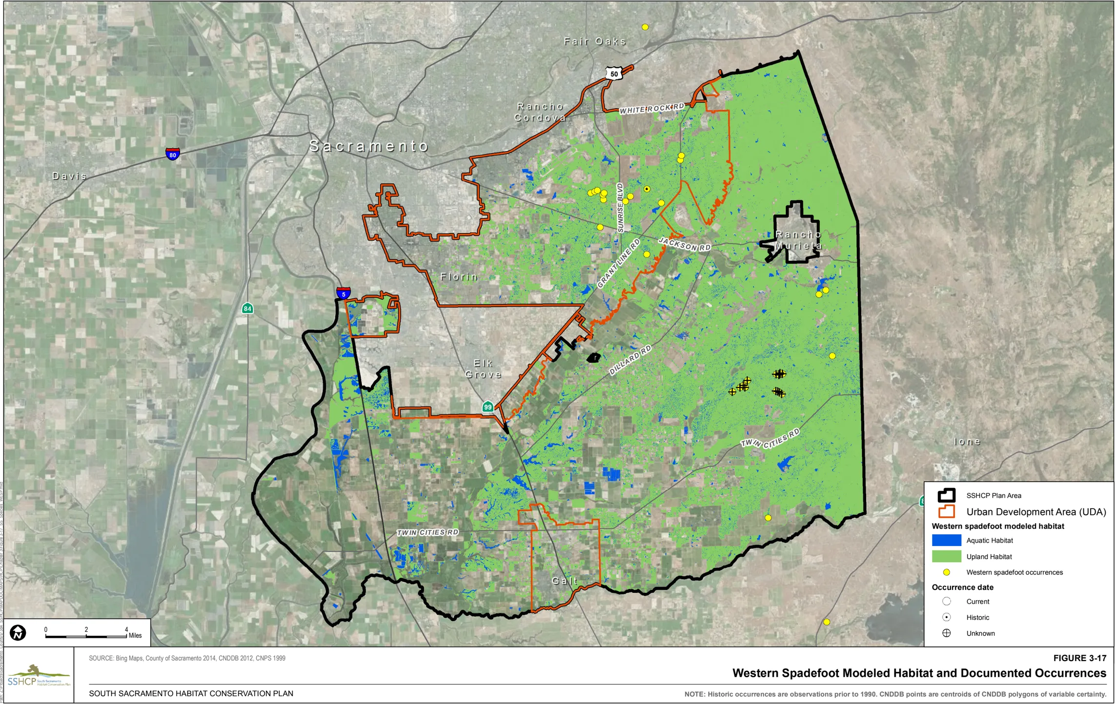
Giant Garter Snake Modeled Habitat
Section titled “Giant Garter Snake Modeled Habitat”The following streams, creeks or drainages are locations that are known to support giant gartersnakes within the Plan Area.
- A prominent drainageway on the Elliot mitigation site, which links to Stone Lakes National Wildlife Refuge (NWR) and is wet year-round.
- Drainage canals south of Elk Grove, which have a past occurrence and link to Stone Lakes NWR; the perennial segments of these canals are suitable habitat.
- Badger Creek and all other creeks that drain into the marsh at the Cosumnes River Preserve, which are likely high-quality habitat due to proximity and connectivity to a significant population of giant gartersnakes; the perennial segments of these creeks are suitable habitat.
- The perennial segments of Laguna Creek (south) and tributaries, which are suitable habitat due to presence of Freshwater Marsh habitat and proximity to documented occurrences.
- The perennial segments of drainages and canals leading from the Cosumnes River Preserve including Deadman’s Gulch, which provides suitable habitat.
Giant gartersnake is known to occur at elevations of up to 230 feet above sea level and to travel up to 400 meters (0.25 mile) between aquatic and upland habitat. Therefore, the waterways described above plus Stream/Creek, Freshwater Marsh, Open Water, and Seasonal Wetland that are entirely or partially within 0.25 mile of the aforementioned waterways and are at or below 230 feet in elevation are modeled as high-value aquatic habitat. In addition to high-value aquatic habitat, non-high value aquatic habitat was defined as Stream/Creek, Freshwater Marsh, Open Water, and Seasonal Wetland that is up to 0.25 mile away from high-value habitat and is at or below 230 feet in elevation.
Upland habitat for giant gartersnake is Mixed Riparian Scrub and Valley Grassland within a distance of 0.25 mile from modeled aquatic habitat and is at or below an elevation of 230 feet. High-value upland habitat for giant gartersnake is defined as upland habitat within 200 feet of high-value aquatic giant gartersnake habitat (i.e., Stream/Creek, Freshwater Marsh, Open Water, and Seasonal Wetland) that is at or below 230 feet in elevation.
Figure 3-18 illustrates the location of modeled habitat as well as the documented occurrences of giant gartersnake within the Plan Area.
Western Pond Turtle (Actinemys marmorata)
Section titled “Western Pond Turtle (Actinemys marmorata)”Habitat Requirements
Section titled “Habitat Requirements”Western pond turtles inhabit a variety of aquatic habitats from sea level to elevations of 1,980 meters (6,500 feet). They are found in fresh to brackish aquatic habitats including marshes, rivers, ponds, and streams. Western pond turtles also may occur in created habitats such as irrigation ditches, reservoirs, and sewage and millponds. Preferred aquatic habitat is characterized by slow moving or quiet water, emergent aquatic vegetation, deep pools with undercut banks for refugia, partially submerged rocks and logs, open mud banks and matted floating vegetation for thermoregulatory basking. Western pond turtles use aquatic habitats primarily for foraging, thermoregulation, breeding, and avoidance of predators (Boyer 1965; Holland 1994; Reese and Welsh 1998a). Hatchling and young turtles (1 year) require shallow water areas (less than 30 centimeters [12 inches] deep) dominated primarily by emergent aquatic reeds ( Juncus spp.) and sedges (Holland 1991), and have been observed to avoid areas of open water lacking these emergent plant species (Boyer 1965; Holland 1994; Hays et al. 1999; Reese and Welsh 1998a). Highly fluctuating flow rates associated with aquatic habitats may diminish habitat quality for western pond turtle (Reese and Welsh 1998b).
Western pond turtles ‘hibernate’ in both aquatic and upland habitats. Aquatic hibernacula consist of rocks, logs, mud, and undercut areas along banks while upland hibernacula consist of burrows in leaf litter, heavy brush, or soil (Holland 1994). Western pond turtles are believed to hibernate between November 1 and March 1 (McDermott, pers. comm. 2015). In woodland and sage scrub habitats along coastal streams in central California, most western pond turtles leave the drying creeks in late summer and return after winter floods. Upland nesting sites must be dry and often have a high clay or silt component. Typically, western pond turtles dig nests in open sunny areas that are on slopes no steeper than 25 degrees, and typically within 300 feet of the aquatic habitat (McDermott, pers. comm. 2015).
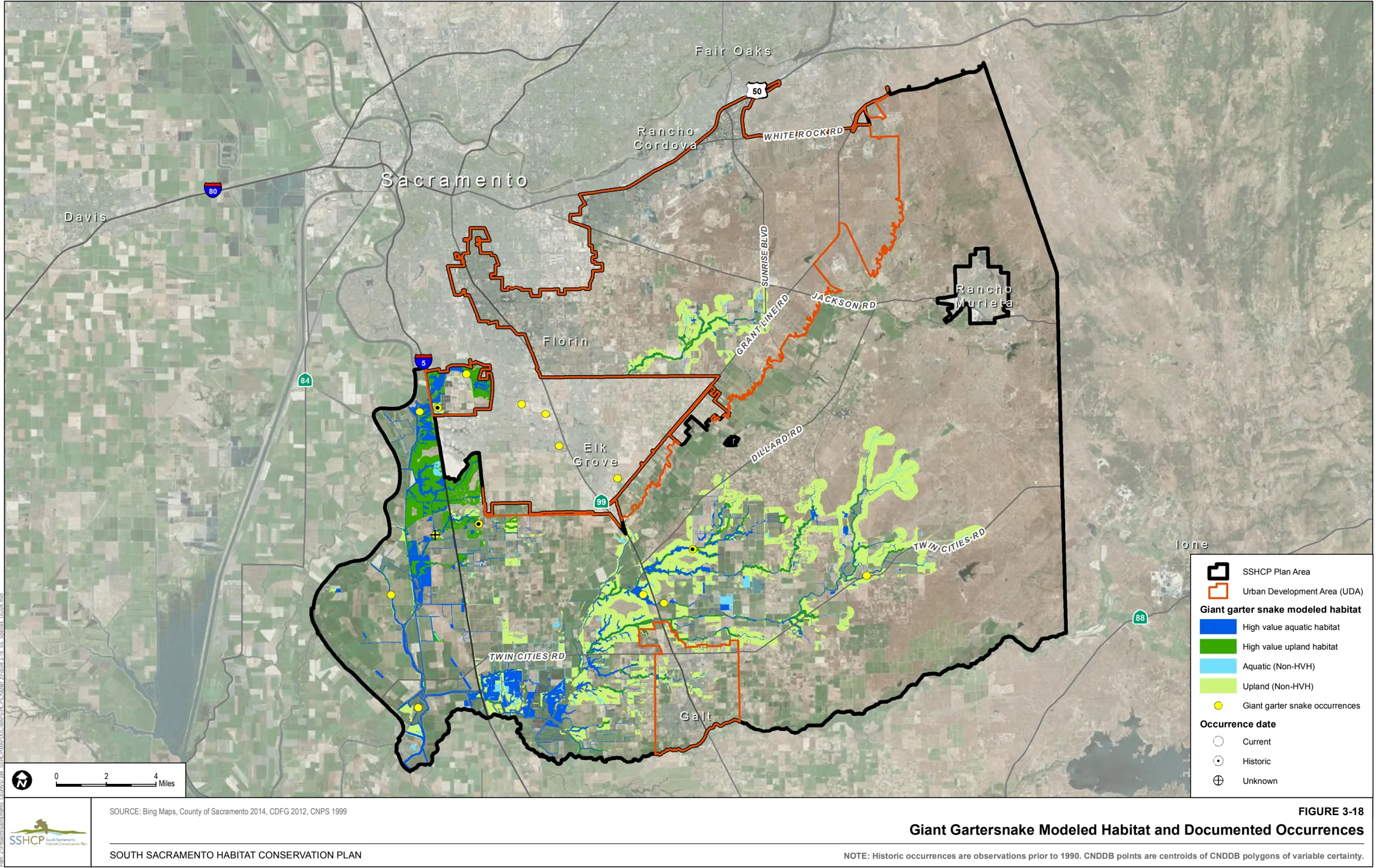
Land Cover Types Relevant to Habitat Requirements
Section titled “Land Cover Types Relevant to Habitat Requirements”Based on life history descriptions aquatic land cover types that provide suitable habitat for western pond turtles include Freshwater Marsh, Open Water, and Stream/Creek. Land cover types that provide suitable upland habitat include Blue Oak Woodland, Blue Oak Savanna, Mine Tailing Riparian Woodland, Mixed Riparian Woodland, Mixed Riparian Scrub, and Valley Grassland when these land covers are near suitable aquatic habitat (Table 3-2).
Occurrences within the Plan Area
Section titled “Occurrences within the Plan Area”There are 19 documented occurrences of western pond turtle within the Plan Area. Three occurrences are within the UDA including two in PPU 2 and one in PPU 4. Sixteen occurrences are outside of the UDA including one in PPU 5, seven in PPU 6, and eight in PPU 7.
Model Assumptions
Section titled “Model Assumptions”- Western pound turtle has been recorded along creek and stream reaches throughout the Plan Area.
- Holland (1994) reported that in the fall and spring, hatchling turtles may move as far as 400 meters (0.25 mile) from their upland nest locations to aquatic sites nearby.
Western Pond Turtle Habitat Model
Section titled “Western Pond Turtle Habitat Model”Western pond turtle modeled aquatic habitat include all Stream/Creek land cover that occurs throughout the Plan Area and Freshwater Marsh and Open Water land covers within 400 meters (0.25 mile) of all Stream/Creek land cover. Western pond turtle modeled upland habitat is Blue Oak Woodland, Blue Oak Savanna, Mine Tailing Riparian Woodland, Mixed Riparian Woodland, Mixed Riparian Scrub, and Valley Grassland within 0.25 mile of modeled aquatic habitat.
Figure 3-19 illustrates the location of modeled habitat as well as the documented occurrences of western pond turtle within the Plan Area.
3.4.5 Birds
Section titled “3.4.5 Birds”Cooper’s Hawk (Accipiter cooperii)
Section titled “Cooper’s Hawk (Accipiter cooperii)”Habitat Requirements
Section titled “Habitat Requirements”Throughout its range, the Cooper’s hawk nests in a wide variety of woodland and forest habitats, including oak woodland, riparian woodland, coniferous, deciduous, and mixed forest, woodlots, and suburban and urban areas. In much of California’s lowland valley and foothill landscapes, including those within the Plan Area, this species appears strongly associated with live oak woodland (Asay 1987). Dense canopy closure is a consistent feature of most nest sites, and the tallest tree in the stand is often selected for nesting (Kennedy 1988). In a study of 77 Cooper’s hawk nests in California, Asay (1987) found that nearly all nests (i.e., 75) were in live oak trees. The other two nests were in a blue oak and California sycamore; and these trees were in stands of live oak. Riparian woodlands also provide important habitat for Cooper’s hawks in Sacramento County (Trochet, pers. comm. 2004).
Cooper’s hawks also breed in urban and suburban areas. Several urban populations of Cooper’s hawks have been well documented (Beebe 1974; Mannan et al. 2004; Murphy et al. 1988; Rosenfield et al. 1991; Stahlecker and Beach 1979). Cooper’s hawks appear tolerant of habitat fragmentation and human disturbance near the nest (Beebe 1974; Murphy et al. 1988; Palmer 1988; Rosenfield et al. 1992). Urban nest sites have included isolated trees within 492 feet (150 meters) of commercial and recreational activities, and 66 to 98 feet (20 to 30 meters) of residential houses (Rosenfield and Bielefeldt 1993; Stahlecker and Beach 1979).
Cooper’s hawks are considered aggressive ambush predators, using concealment to catch prey. Surprise attacks are often initiated at close range from behind an obstruction (Roth and Lima 2003). They often use a series of brief perch and scan episodes to locate and capture prey. In open habitats, Cooper’s hawks occasionally hunt from the air, scanning the ground and stooping on prey (Rosenfield and Bielefeldt 1993). Cooper’s hawks forage in structurally diverse woodland habitats that provide suitable prey abundance and diversity (i.e., medium-sized birds) and large numbers of sites within which to perch, scan, and launch attacks on potential prey.
Land Cover Types Relevant to Habitat Requirements
Section titled “Land Cover Types Relevant to Habitat Requirements”SSHCP land cover types that provide suitable habitat for foraging based on life history descriptions include Blue Oak Woodland, Blue Oak Savanna, Mine Tailing Riparian Woodland, Mixed Riparian Woodland, and Mixed Riparian Scrub. Suitable habitat for nesting includes Blue Oak Woodland, Mine Tailing Riparian Woodland, Mixed Riparian Woodland, and Mixed Riparian Scrub (Table 3-2).
Occurrences within the Plan Area
Section titled “Occurrences within the Plan Area”There are 20 documented occurrences of Cooper’s hawk within the Plan Area. Seven are within the UDA including one in PPU 1, two in PPU 2, one in PPU 3, two in PPU 4, and one that is not within a PPU. Thirteen occurrences are outside of the UDA including two in PPU 5, eight in PPU 6, two in PPU 7, and one that is not within a PPU.
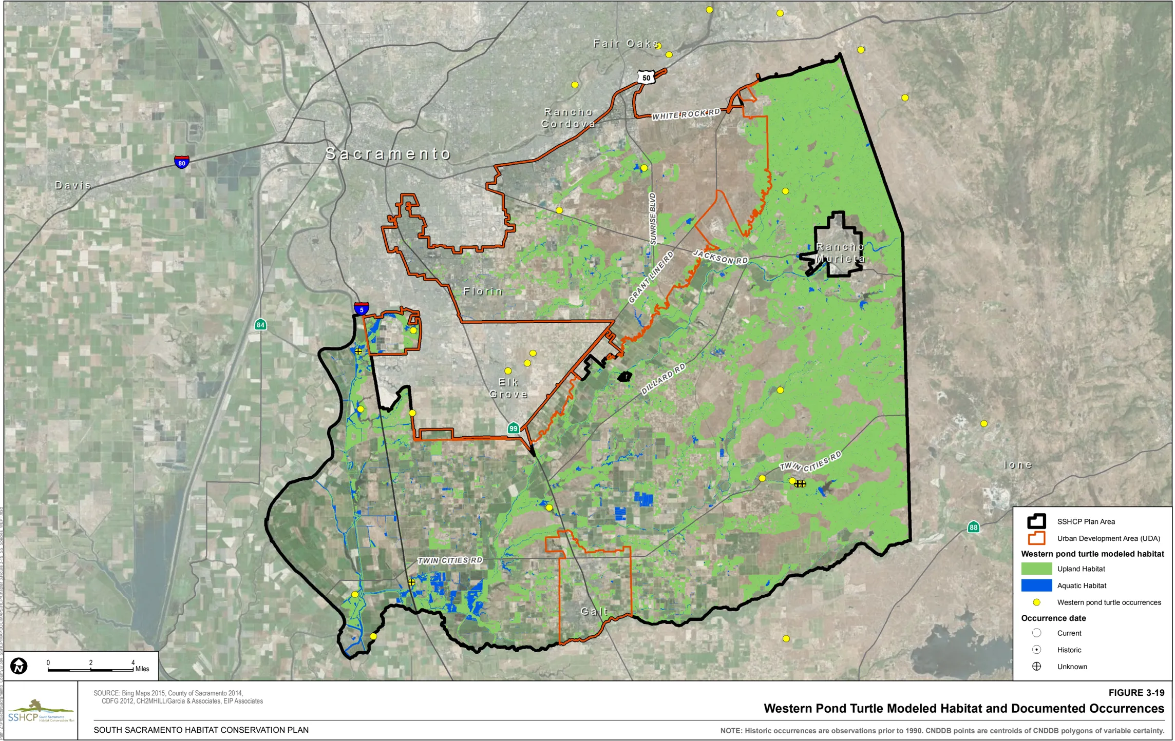
Model Assumptions
Section titled “Model Assumptions”- Overall distribution, abundance, and population structure for Cooper’s hawk are not well known within the Plan area.
- In urban Tucson, Arizona, home range size for nine subadult Cooper’s hawks during their first fall/winter averaged 1,905 acres (771 hectares) (Mannan et al. 2004).
- In Tucson, Mannan and Boal (2000) studied the movements of adult male Cooper’s hawks in adjacent home ranges during the breeding season. Home range sizes for nine individuals ranged between 33 and 323 acres (13 and 131 hectares) and averaged 162 acres (66 hectares).
- In a study of nesting Cooper’s hawks in the Sacramento area, the average distance between adjacent nests was 0.99 mile (1.6 kilometers) (Asay 1987).
- Most Cooper’s hawks breeding in California are permanent, non-migratory residents; however, Cooper’s hawks breeding in montane habitats may exhibit seasonal movements, moving to snow-free lower elevations during winter (Zeiner et al. 1990).
Cooper’s Hawk Habitat Model
Section titled “Cooper’s Hawk Habitat Model”Modeled foraging habitat is Blue Oak Woodland, Blue Oak Savanna, Mine Tailing Riparian Woodland, Mixed Riparian Woodland, and Mixed Riparian Scrub throughout the Plan Area. Modeled nesting habitat is Blue Oak Woodland, Mine Tailing Riparian Woodland, Mixed Riparian Woodland, and Mixed Riparian Scrub throughout the Plan Area.
Figure 3-20 illustrates the location of modeled habitat as well as the documented occurrences of Cooper’s hawk within the Plan Area.
Ferruginous Hawk (Buteo regalis)
Section titled “Ferruginous Hawk (Buteo regalis)”Habitat Requirements
Section titled “Habitat Requirements”The ferruginous hawk is considered an ‘open country’ species that inhabits the grasslands, shrub steppes, and deserts of western North America. During the winter, ferruginous hawks use grasslands and arid areas, particularly where pocket gophers, ground squirrels, rabbits, or prairie dogs are abundant. Ferruginous hawks also winter near cultivated fields that support populations of pocket gophers (Bechard and Schmutz 1995), and are known to use urban open space grasslands as long as prey is available (Berry et al. 1998). Ferruginous hawks have been observed in open grassland habitats and non-vineyard agricultural areas in the Plan Area (Manolis, pers. comm. 2004). Characteristics of these grasslands and agricultural lands are that they support abundant prey and include friable soils (for digging and burrowing), moderate to dense vegetative cover (particularly grasses), and some topographic variation.
Land Cover Types Relevant to Habitat Requirements
Section titled “Land Cover Types Relevant to Habitat Requirements”SSHCP land cover types that provide suitable habitat for foraging based on life history descriptions include Valley Grassland, Irrigated Pasture-Grassland, Vernal Pool, Seasonal Wetland, and Swale (Table 3-2).
Occurrences within the Plan Area
Section titled “Occurrences within the Plan Area”There are 26 documented occurrences of Ferruginous hawk within the Plan Area. Eight occurrences are within the UDA including seven in PPU 2 and one in PPU 4. Eighteen occurrences are outside of the UDA including six in PPU 5, four in PPU 6, seven in PPU 7, and one that in not within a PPU.
Model Assumptions
Section titled “Model Assumptions”- Ferruginous hawks do not regularly breed in California, with the most recent breeding being recorded in 1989 in northeastern California (Harlow and Bloom 1989).
- Occurrence information is not well documented from within the Plan Area.
- The spatial requirements of ferruginous hawks during winter have not been widely reported (Bechard and Schmutz 1995) and what constitutes the minimum size of suitable winter foraging habitat is unknown for most areas.
- Bechard and Schmutz (1995) suggest the Ferruginous hawk may defend winter territories. Winter densities in Utah have been reported at one individual per 3.60 square miles (Smith and Murphy 1978), and Plumpton and Andersen (1997) found a mean daily Minimum Convex Polygon home range size of 1.36 square miles.
Ferruginous Hawk Habitat Model
Section titled “Ferruginous Hawk Habitat Model”Modeled foraging habitat is Valley Grassland, Irrigated Pasture-Grassland, Vernal Pool, Seasonal Wetland, and Swale land cover located anywhere in the Plan Area.
Figure 3-21 illustrates the location of modeled habitat as well as the documented occurrences of Ferruginous hawk within the Plan Area.
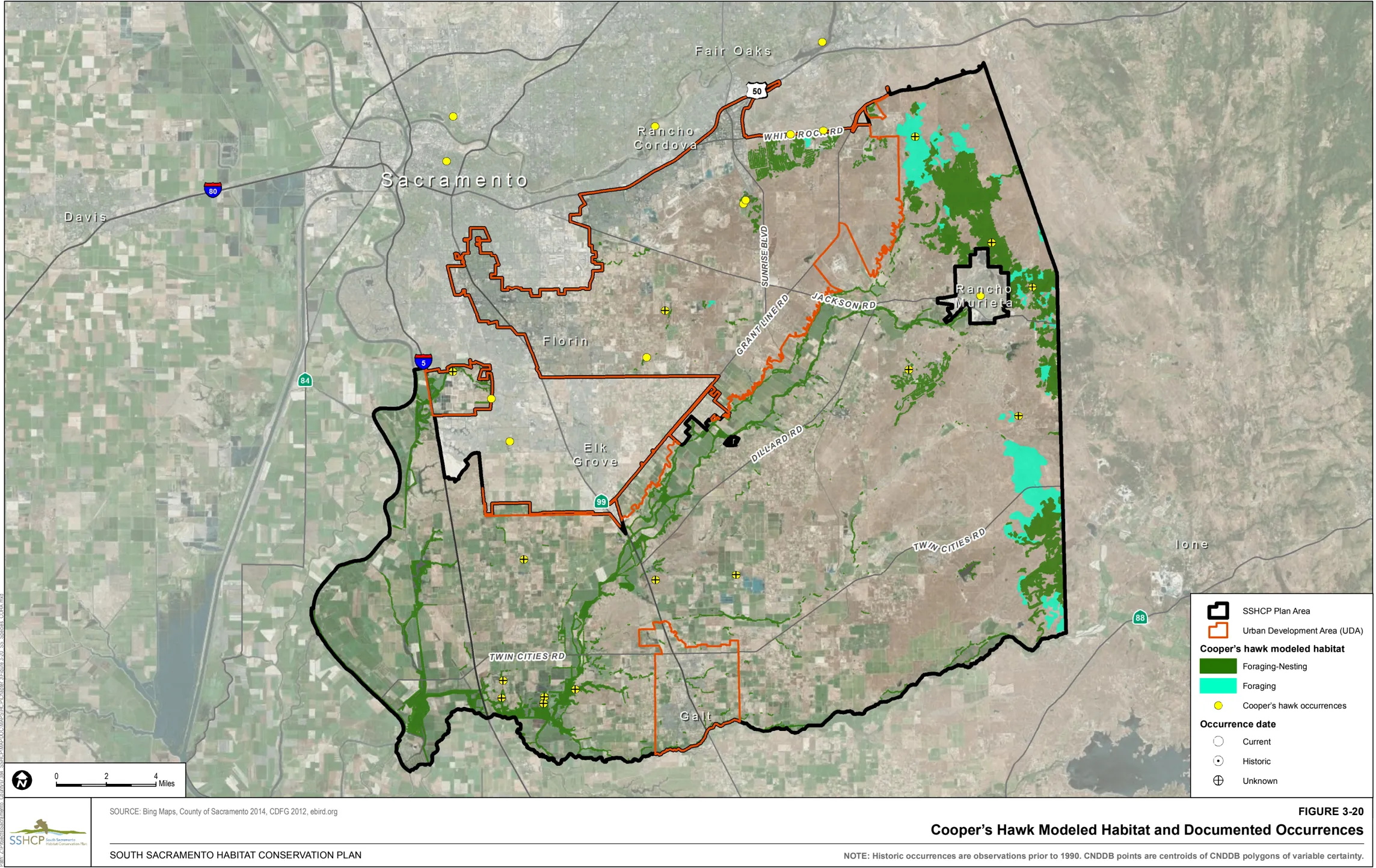
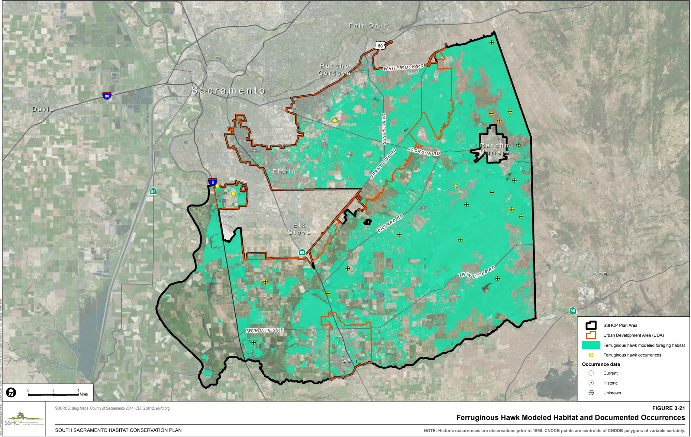
Greater Sandhill Crane (Grus_canadensis_tabida)
Section titled “Greater Sandhill Crane (Grus_canadensis_tabida)”Habitat Requirements
Section titled “Habitat Requirements”Greater sandhill cranes wintering in and adjacent to the Plan Area use open agricultural habitats, natural vegetation communities, and seasonally managed wetlands. After the onset of winter rains, Sandhill Cranes begin foraging for invertebrates by probing soils in grassland habitats and overturning cattle dung. They also hunt for mice in taller grassland vegetation (Littlefield and Ivey 2000). They appear to avoid grassland habitats when vegetation exceeds 10 inches (25 centimeters). Invertebrates are also consumed in natural and managed seasonal wetlands.
Grain is also an important component to the sandhill crane’s diet and as such agricultural habitat types are frequently utilized as foraging habitat. Common habitat types used for foraging include pastures, alfalfa, corn (chopped, disked, flooded, and stubble), tomatoes (flooded, ripped), and wheat (disked, ripped, flooded, stubble) (Ivey and Herziger 2003). Ivey (pers. comm. 2004) rated agriculture crops in the Plan Area in order of importance. Rice and corn were rated the highest, followed by winter wheat and irrigated pasture. Alfalfa was the next highest rated crop, followed by hay, dryland pasture, and row crops. Sandhill Crane use in the above crop types occurs even though the crops are harvested for farming income.
Habitats also important for greater sandhill cranes include flooded fields for roosting and rocky uplands (e.g., dirt and gravel roads) for collecting ‘grit.’ Roosting areas are located in shallowly flooded areas where cranes loaf during the day and seek protection from terrestrial predators at night. Although they will select sites with emergent vegetation along the periphery of the wetland, they rarely use roosts with heavy emergent vegetation (Littlefield and Ivey 2000).
Land Cover Types Relevant to Habitat Requirements
Section titled “Land Cover Types Relevant to Habitat Requirements”SSHCP land cover types that provide suitable habitat for foraging based on life history descriptions include Cropland, Irrigated Pasture-Grassland, Valley Grassland, Seasonal Wetland, and Freshwater Marsh. Suitable habitat for night roosting include Vernal Pool, Seasonal Wetland, and Freshwater Marsh (Table 3-2).
Occurrences within the Plan Area
Section titled “Occurrences within the Plan Area”There are 210 documented occurrences of greater sandhill crane within the Plan Area. Eight are within the UDA including one in PPU 1, one in PPU 4, and six in PPU 8. Two hundred and two are outside the UDA, including 191 in PPU 6 and 11 in PPU 7.
Model Assumptions
Section titled “Model Assumptions”- Greater sandhill cranes travel limited distances to foraging sites from night roost areas. The average distance traveled was 0.88 mile (range 0.17 to 1.89 miles) (Ivey and Herziger 2003) and 1.74 miles (Pogson 1990) between roost sites and foraging areas.
- The size of roost sites is variable. Sandhill cranes roosting in Oregon used sites between 1 and 300 acres (0.5 and 120 hectares).
- Littlefield (1993) recommended roost sites should be at least 20 acres (8 hectares).
- Greater sandhill crane use in the Plan Area principally occurs in the Cosumnes Floodplain (Sloat, as cited in SSHCP Appendix B).
Greater Sandhill Crane Habitat Model
Section titled “Greater Sandhill Crane Habitat Model”Modeled night roosting habitat is Vernal Pool, Seasonal Wetland, and Freshwater Marsh within 2 miles of greater sandhill crane occurrences per discussion with USFWS staff and CDFW staff (Gardner, pers. comm. 2010; Adelsbach, pers. comm. 2010). This element of the species’ model is consistent with the Conservation Assessment for Greater Sandhill Cranes Wintering on the Cosumnes River Floodplain and Delta Regions of California (Littlefield and Ivey 2000), although extends beyond the Cosumnes River Floodplain within the Plan Area. Modeled foraging habitat is Cropland, Irrigated Pasture-Grassland, Valley Grassland, Seasonal Wetland, and Freshwater Marsh within 1.75 miles of modeled roosting habitat.
High-value habitat for greater sandhill crane is defined as modeled habitats above sea level and outside the UDA (i.e., modeled habitats within the UDA are excluded).
Figure 3-22 illustrates the location of modeled habitat as well as the documented occurrences of greater sandhill crane within the Plan Area.
Loggerhead Shrike (Lanius ludovicianus)
Section titled “Loggerhead Shrike (Lanius ludovicianus)”Habitat Requirements
Section titled “Habitat Requirements”Loggerhead shrikes occur in dry, open habitats including grasslands, pastures with fence rows, agricultural fields, open woodlands (savannas), scrub, and riparian areas. They inhabit open areas with clear visibility for hunting, perches for scanning, and scattered small trees and large shrubs for nesting. Loggerhead shrikes typically avoid completely treeless and shrubless areas (Cade and Woods 1997), as well as urbanized and densely wooded areas (Grinnell and Miller 1944). Winter foraging habitat is similar to summer breeding and foraging habitat, however, shrikes also use idle pastures and hayfields during the winter (Bartgis 1992).
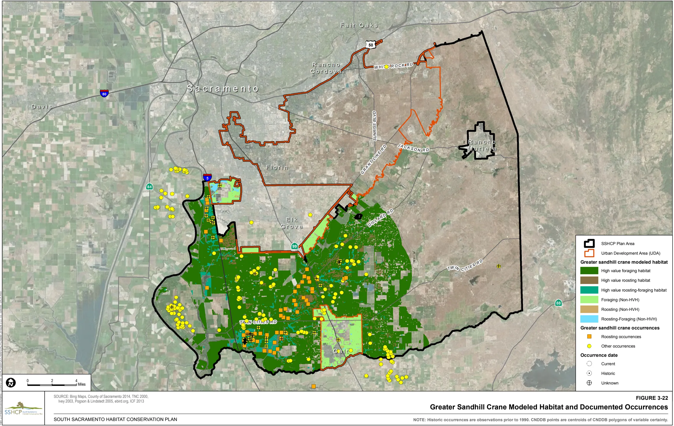
Land Cover Types Relevant to Habitat Requirements
Section titled “Land Cover Types Relevant to Habitat Requirements”SSHCP land cover types that provide suitable habitat for foraging based on life history descriptions include Cropland, Irrigated Pasture-Grassland, Valley Grassland, Vernal Pool, Seasonal Wetland, and Swale; suitable habitat for nesting include Mine Tailing Riparian Woodland, Mixed Riparian Scrub, and Valley Grassland (Table 3-2).
Occurrences within the Plan Area
Section titled “Occurrences within the Plan Area”There are 34 documented occurrences of loggerhead shrike within the Plan Area. Seven are within the UDA including two in PPU 1, one in PPU 2, two in PPU 3, one in PPU 4, and one in PPU 8. Twenty-seven occurrences are outside of the UDA, including three in PPU 5, 15 in PPU 6, seven in PPU 7, and two that are not within a PPU.
Model Assumptions
Section titled “Model Assumptions”- In mainland California, the average size of territories averaged 21 acres (9 hectares) and ranged between 11 acres (4 hectares) and 40 acres (16 hectares) (Yosef 1996).
- Loggerhead shrikes occur year-round in suitable habitat throughout the Plan Area. They are probably regular breeders in the Plan Area in low densities (Trochet, pers. comm. 2004); however, their overall distribution, abundance, and population structure are not well known.
Loggerhead Shrike Habitat Model
Section titled “Loggerhead Shrike Habitat Model”Modeled foraging habitat is Cropland, Irrigated Pasture-Grassland, Valley Grassland, Vernal Pool, Seasonal Wetland, and Swale throughout the Plan Area. Modeled nesting habitat is Mine Tailing Riparian Woodland, Mixed Riparian Scrub, and Valley Grassland throughout the Plan Area.
Figure 3-23 illustrates the location of modeled habitat as well as the documented occurrences of loggerhead shrike within the Plan Area.
Northern Harrier (Circus cyaneus)
Section titled “Northern Harrier (Circus cyaneus)”Habitat Requirements
Section titled “Habitat Requirements”Northern harrier breeds in a variety of open grassland, wetland, and agricultural habitats. Open wetland habitats used for breeding include marshy meadows, wet and lightly grazed pastures, and freshwater and brackish marshes. Northern Harrier breeding habitat also includes dry upland habitats, including grasslands, croplands, drained marshlands, and shrub-steppe in cold deserts.
Although Midwestern populations use wetland habitats more frequently, western populations tend to use upland habitats (e.g., grasslands) disproportionately. Northern harriers winter throughout California where suitable habitat occurs. Wintering habitat includes open areas dominated by herbaceous vegetation, including grasslands, pastures, croplands, coastal sand dunes, brackish and freshwater marsh, and estuaries. Northern harriers rarely occur in forested areas (Grinnel and Miller 1944; MacWhirter and Bildstein 1996; Martin 1987).
Land Cover Types Relevant to Habitat Requirements
Section titled “Land Cover Types Relevant to Habitat Requirements”SSHCP land cover types that provide suitable habitat for foraging based on life history descriptions include Cropland, Irrigated Pasture-Grassland, Valley Grassland, Vernal Pool, Seasonal Wetland, Swale, and Freshwater Marsh. Suitable habitat for nesting includes Cropland, Irrigated Pasture-Grassland, and Valley Grassland (Table 3-2).
Occurrences within the Plan Area
Section titled “Occurrences within the Plan Area”There are 70 documented occurrences of northern harrier within the Plan Area. Twelve are within the UDA including, four in PPU 1, two in PPU 2, two in PPU 3, two in PPU 4, and two in PPU 8. Fifty-eight occurrences are outside of the UDA, including five in PPU 5, 42 in PPU 6, seven in PPU 7, and four that are not within a PPU.
Model Assumptions
Section titled “Model Assumptions”- Reported territory sizes for males range from 2 to 272 acres (0.8 to 110 hectares); females typically defend a smaller territory (Martin 1987; Simmons 1983).
- During the breeding season, reported average home range sizes from eight studies were 420 to 37,067 acres (170 to 15,000 hectares) (MacWhirter and Bildstein 1996).
- Males reportedly will hunt ≥10 kilometers (≥6 miles) from the nest (Barnard 1983; Thompson-Hanson 1984).
- Northern harriers occur in suitable habitat within the Plan Area and are probably regular breeders (Trochet, pers. comm. 2004); however, their overall range, abundance, and population structure are not well known.
Northern Harrier Habitat Model
Section titled “Northern Harrier Habitat Model”Modeled foraging habitat is Cropland, Irrigated Pasture-Grassland, Valley Grassland, Vernal Pool, Seasonal Wetland, Swale, and Freshwater Marsh throughout the Plan Area. Modeled nesting habitat is Cropland, Irrigated Pasture-Grassland, and Valley Grassland throughout the Plan Area.
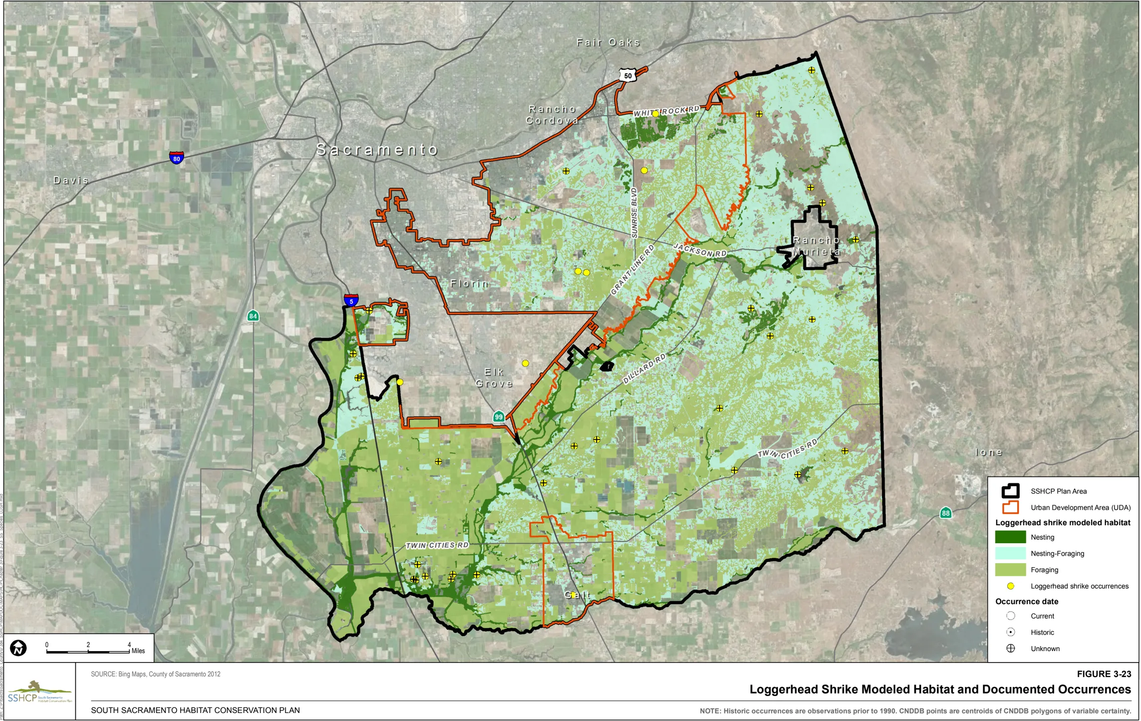
Figure 3-24 illustrates the location of modeled habitat as well as the documented occurrences of northern harrier within the Plan Area.
Swainson’s Hawk (Buteo swainsoni)
Section titled “Swainson’s Hawk (Buteo swainsoni)”Habitat Requirements
Section titled “Habitat Requirements”In the Central Valley of California, there are about 25 different tree species that have been utilized for nesting (CDFG 2010). The most common nest trees are Fremont’s cottonwood (Populus fremontii), oaks ( Quercus spp.), willows ( Salix spp.), walnuts ( Juglans spp.), eucalyptus ( Eucalyptus spp.), pines ( Pinus spp.), and Deodar cedar (Cedrus deodara). Most nest trees are associated with riparian systems. Schlorff and Bloom (1984) found 87% of all Swainson’s hawk’s nests in the Central Valley to be associated with riparian systems. Within his study area in parts of Yolo, Sacramento and San Joaquin Counties, Estep (1989) found 78% of nest trees to be in riparian systems. Swainson’s hawk’s nests are also found well away from waterways in lone trees in fields and pastures, in trees along roadside edges, in small groves, around farm buildings, and in some urban areas. Nest trees can also be found in proximity to farm buildings (Bloom 1980; Swolgaard 2004), often in large, well-established, exotic tree species or relict natives.
Nesting in completely urbanized areas is an unusual phenomenon that has recently been discovered in some particular urban settings: 1979 in Davis and 1983 in Stockton (D. Yee, pers. comm. 2004). Urban-nesting always occurs in association with suitable foraging habitat being relatively close to the nest (e.g., Stockton and Davis are surrounded in all directions by high-quality foraging habitat in suitable agricultural crops) (Holt pers. obs., as cited in SSHCP Appendix B).
Swainson’s hawks forage successfully in a variety of farming habitats. Alfalfa is the crop that provides the highest foraging value due to high prey densities and regular harvesting and irrigation that make prey available for capture. However, a variety of suitable farming habitats also provide valuable foraging habitats at differing times and for different prey species during the period of time when Swainson’s hawks are in the Plan Area. This mosaic of suitable foraging habitats provides the best opportunity for regular and successful hunting during the nesting season (Holt pers. obs., as cited in SSHCP Appendix B).
Dry pasture is largely comprised of annual grassland land covers and is grazed primarily by cattle during some part of the year. A large portion of the Swainson’s hawk’s historical habitat is believed to be similar to dry pasture, although the prey species, their abundance, and availability are likely quite different today as introduced grasses and forbs and introduced grazers now dominate this habitat (Holt pers. obs., as cited in SSHCP Appendix B). Therefore, direct comparisons with historical conditions should be considered with caution. Swolgaard (2004) observed Swainson’s hawks foraging in grassland habitats, but noted that its frequency of use was lower than expected based on its availability.
Land Cover Types Relevant to Habitat Requirements
Section titled “Land Cover Types Relevant to Habitat Requirements”SSHCP land cover types that provide suitable habitat for foraging based on life history descriptions include Cropland, Irrigated Pasture-Grassland, Valley Grassland, Vernal Pool, Seasonal Wetland, and Swale. Suitable habitat for nesting includes mixed Riparian Woodland and Mixed Riparian Scrub (Table 3-2).
Occurrences within the Plan Area
Section titled “Occurrences within the Plan Area”There are 410 documented occurrences of Swainson’s hawk within the Plan Area. Sixty-two are within the UDA, including 10 within PPU 1, five in PPU 2, eight in PPU 3, 17 in PPU 4, 20 in PPU 8, and two that are not within a PPU. Three hundred and forty either are outside of the UDA, including 35 in PPU 5, 284 in PPU 6, 28 in PPU 8, and one that in not within a PPU.
Model Assumptions
Section titled “Model Assumptions”- Radio-tagged male Swainson’s hawks were recorded to travel as far as 17 miles (Estep 1989) and 18 miles (Babcock 1995) from a nest to exploit more favorable agricultural foraging opportunities.
- Estep (1989) found mean home ranges to be 6,818 acres. While Babcock (1995) plotted out 9,978 acres as the mean home range in his study area in eastern Yolo County.
- Swainson’s hawks are typically not found at elevations above 500 feet in Sacramento County (Gifford et al. 2012).
- Swainson’s hawk occurrences are recorded throughout the Plan Area (CDFG 2010; ebird.org 2005-2010; Estep 2006 and 2007; Gill Ranch Survey 2003).
Swainson’s Hawk Habitat Model
Section titled “Swainson’s Hawk Habitat Model”Modeled foraging habitat is Cropland, Irrigated Pasture-Grassland, Valley Grassland, Vernal Pool, Seasonal Wetland, and Swale throughout the Plan Area at elevations below 500 feet. Modeled nesting habitat is mixed Riparian Woodland and Mixed Riparian Scrub throughout the Plan Area at elevations below 500 feet.
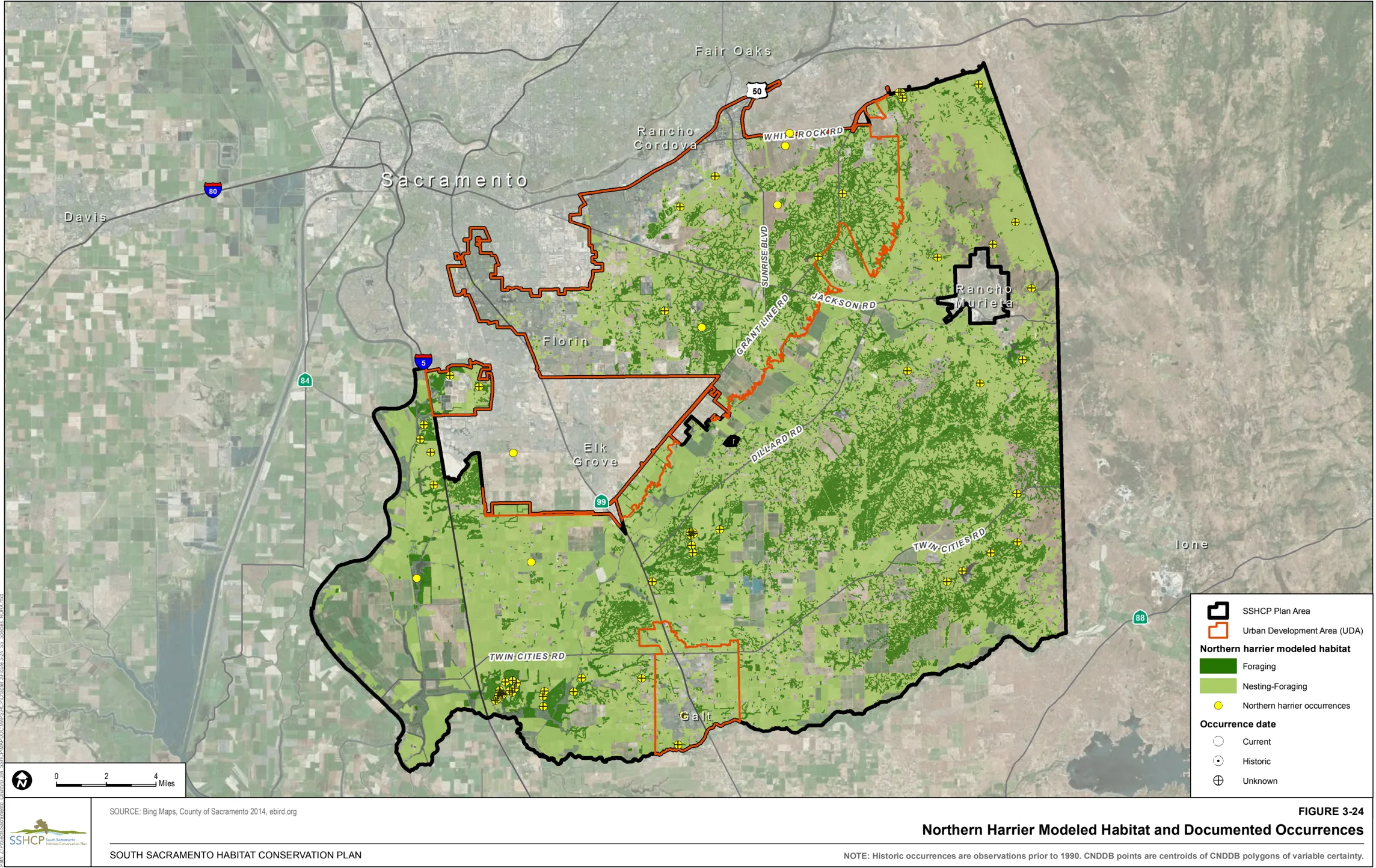
High-value habitat for Swainson’s hawk is defined by the SSHCP as modeled foraging habitat occurring in the western portion of the Plan Area (within PPUs 4, 6, and 8).
Figure 3-25 illustrates the location of modeled habitat as well as the documented occurrences of Swainson’s hawk within the Plan Area.
Tricolored Blackbird (Agelaius tricolor)
Section titled “Tricolored Blackbird (Agelaius tricolor)”Habitat Requirements
Section titled “Habitat Requirements”During the breeding season, tricolored blackbirds typically nest in dense colonies (some estimated as having 200,000+ nests), with males defending small territories and mating with one to four females (Beedy and Hamilton 1999). They are also considered itinerant breeders, sometimes nesting more than once at different locations during the breeding season. Studies by Neff (1937) reported that nesting colonies are often located in seasonal wetlands with tules and cattails present. More recent studies indicate that nesting colonies are also regularly found in Himalayan blackberries (Rubus discolor) (Cook 1999) and grain fields (DeHaven 2000). Other substrates where they have been observed nesting include giant European reed (Arundo donax), safflower (Carthamus tinctorius) (DeHaven et al. 1975), tamarisk ( Tamarix spp.), elderberry ( Sambucus spp.), poison-oak (Toxicodendron diversilobum), and riparian scrublands and forests (e.g., Salix, Populus , and Fraxinus spp.) (American Birds file data).
Tricolored blackbird foraging habitats in all seasons include annual grasslands, wet and dry vernal pools and other seasonal wetlands, agricultural fields (such as large tracts of alfalfa and pastures with continuous haying schedules, and recently tilled fields), cattle feedlots, and dairies. They also forage occasionally in Mixed Riparian Scrub habitats along marsh borders. Weed-free row crops, intensively managed vineyards, and orchards do not serve as regular foraging sites (Beedy and Hamilton 1997, 1999; DeHaven 2000).
Land Cover Types Relevant to Habitat Requirements
Section titled “Land Cover Types Relevant to Habitat Requirements”SSHCP land cover types that provide suitable habitat for foraging based on life history descriptions include Cropland, Irrigated Pasture-Grassland, Valley Grassland, Vernal Pool, Seasonal Wetland, Swale, Freshwater Marsh, and Open Water. Suitable habitat for nesting includes Cropland, Valley Grassland, Seasonal Wetland, and Freshwater Marsh (Table 3-2).
Occurrences within the Plan Area
Section titled “Occurrences within the Plan Area”There are 36 documented occurrences of tricolored blackbird within the Plan Area. Twenty-two occurrences are within the UDA, including three in PPU 2, 15 in PPU 3, one in PPU 4, and three that are not within a PPU. Fourteen occurrences are outside of the UDA, including three in PPU 5, four in PPU 6, five in PPU 7, and two that are not within a PPU.
Model Assumptions
Section titled “Model Assumptions”- Over the past couple of decades tricolored blackbird colony sites have been documented throughout the Plan Area.
- DeHaven et al. (1975) banded 33,058 nestlings and only 39% of band recoveries were relocated within 16 kilometers (10 miles) of natal colonies.
- Most tricolored blackbirds forage within five kilometers (three miles) of their colony sites (Orians 1961), but commute distances of up to 13 kilometers (8 miles) have been reported (Hamilton, pers. comm. 2004).
Tricolored Blackbird Habitat Model
Section titled “Tricolored Blackbird Habitat Model”Modeled foraging habitat is Cropland, Irrigated Pasture-Grassland, Valley Grassland, Vernal Pool, Seasonal Wetland, Swale, Freshwater Marsh, and Open Water throughout the Plan Area. Modeled nesting habitat is Cropland, Valley Grassland, Seasonal Wetland, and Freshwater Marsh throughout the Plan Area.
Figure 3-26 illustrates the location of modeled habitat as well as the documented occurrences of tricolored blackbird within the Plan Area.
Western Burrowing Owl (Athene cunicularia hypugaea)
Section titled “Western Burrowing Owl (Athene cunicularia hypugaea)”Habitat Requirements
Section titled “Habitat Requirements”The most important habitat consideration for burrowing owls is the availability of underground burrows throughout their life cycle. Throughout their range, they use burrows excavated by fossorial mammals or reptiles (Karalus and Eckert 1987). Where the number and availability of natural burrows are limited, owls may occupy other natural and unnatural sites such as rock outcrops (Gleason and Johnson 1985; Rich 1986), concrete and asphalt (Trulio 1994), cavities under piles of rubble, drainage culverts, discarded pipe and other tunnel-like structures, and human-made artificial burrows (Collins and Landry 1977).
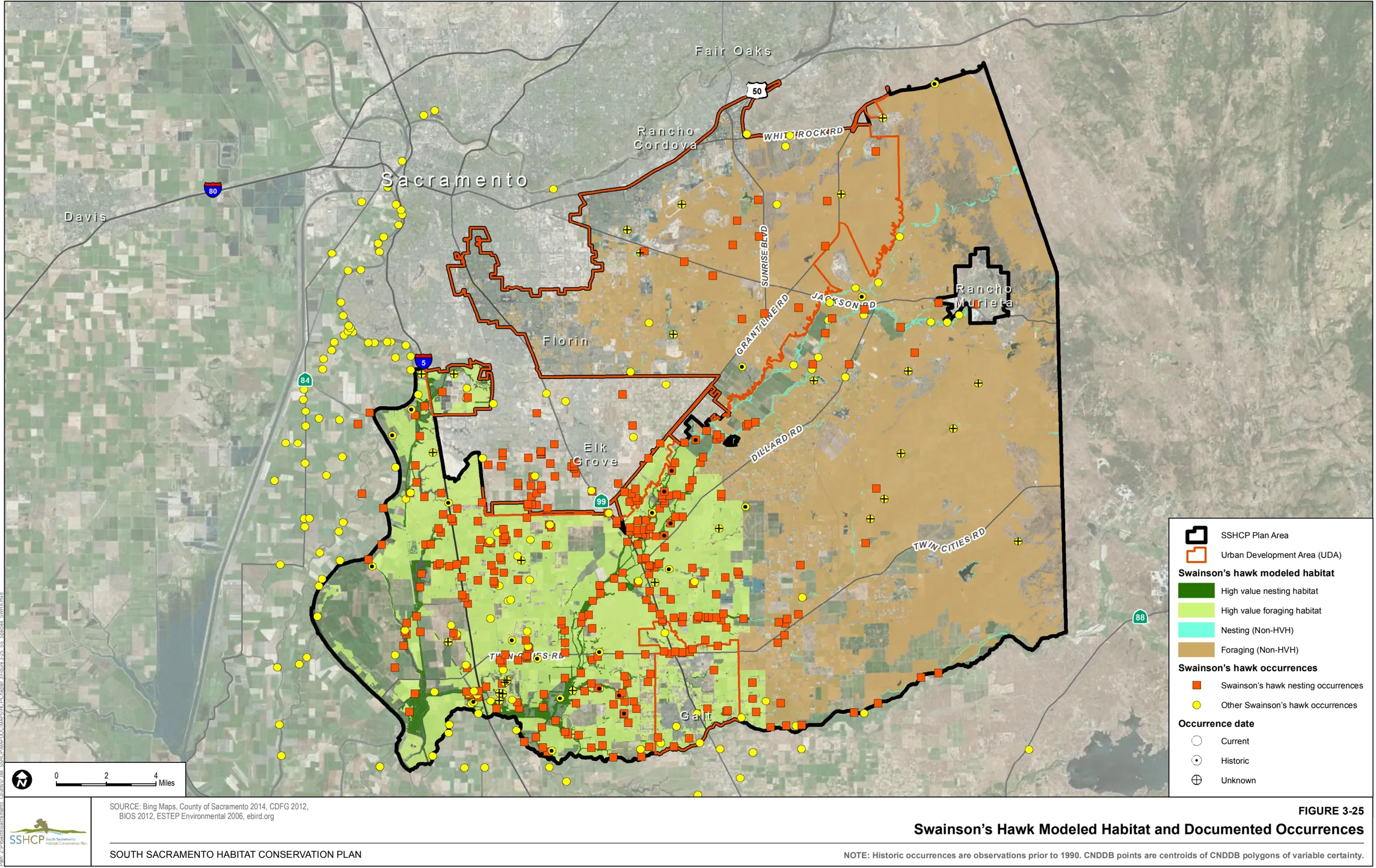
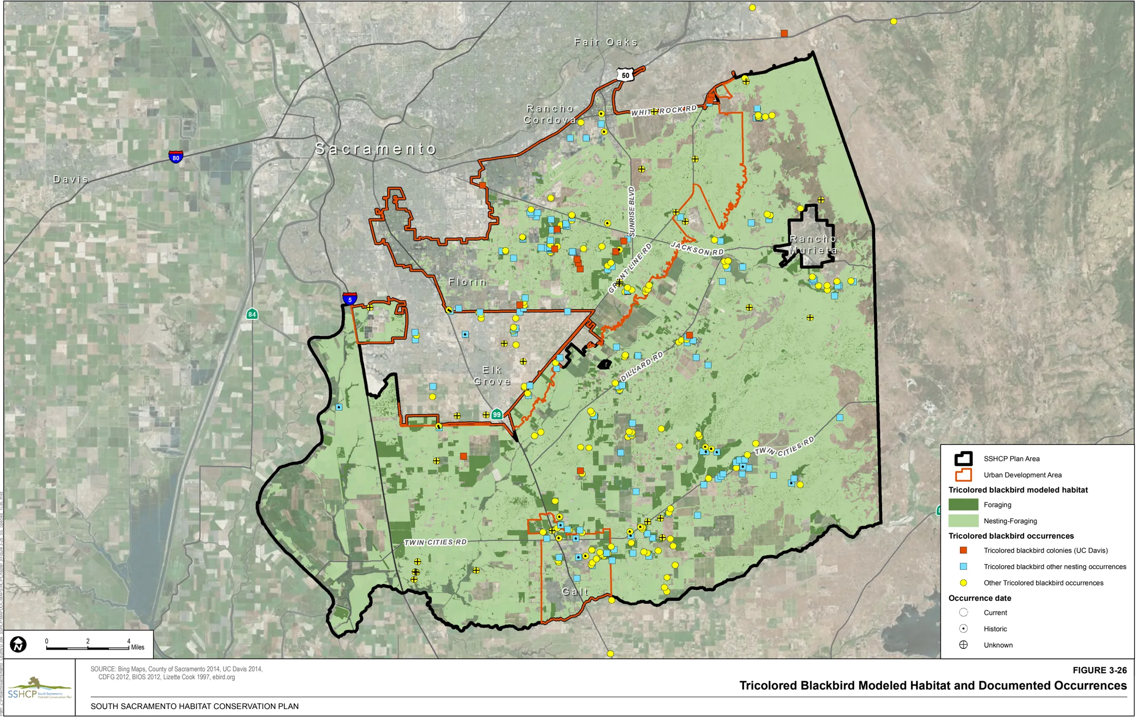
Over their range, burrowing owls inhabit grasslands, deserts, sagebrush scrub, agricultural areas (including pastures and untilled margins of Cropland), earthen levees and berms, coastal uplands, and urban vacant lots, as well as the undeveloped margins of airports, golf courses, roads, and railroad beds. In California, the four cover types most frequently occupied by burrowing owls are: grasslands adjacent to intensive agriculture; intensive agriculture where owls nest along irrigation banks; large, unfragmented grasslands; and small grassland and ruderal patches surrounded by and adjacent to urban development (Rosenberg and DeSante 1997; Rosenberg and Haley 2004).
Land Cover Types Relevant to Habitat Requirements
Section titled “Land Cover Types Relevant to Habitat Requirements”SSHCP land cover types that provide suitable foraging habitat based on life history descriptions include Blue Oak Savanna, Cropland, Irrigated Pasture-Grassland, Valley Grassland, Vernal Pool, Seasonal Wetland, Swale, and Stream/Creek (VPIH); suitable habitat for nesting include Valley Grassland, Blue Oak Savanna, Cropland, and Irrigated Pasture-Grassland (Table 3-2).
Occurrences within the Plan Area
Section titled “Occurrences within the Plan Area”There are 97 documented occurrences of western burrowing owl within the Plan Area. Thirty-six are within the UDA, including two in PPU 1, 16 in PPU 2, two in PPU 3, 12 in PPU 4, and four that are not within a PPU. Sixty-one are outside of the UDA, including three in PPU 1, one in PPU 5, 30 in PPU 6, 23 in PPU 7, and four that are not within a PPU.
Model Assumptions
Section titled “Model Assumptions”- During the breeding season, adult male Burrowing Owls have been documented foraging over a range of 0.8 to 1.2 square miles (2 to 3 square kilometers) (Haug and Oliphant 1987), and primarily within 0.4 mile (600 meters) of the nest burrow (Gervais et al. 2003; Rosenberg and Haley 2004).
- In two burrowing owl demography studies conducted in the San Francisco Bay Area, owls moved an average distance of 0.5 to 0.9 mile (0.8 to 1 kilometers) between breeding seasons. Of this sample population, 27% remained at the same nest site; 14% dispersed less than 265 feet (81 meters) away; 34% dispersed 0.05 to 0.5 mile (80 to 805 meters); 8% dispersed 0.5 to 1.0 mile (805 meters to 2 kilometers); 14% dispersed 1 to 5 mile (2 to 8 kilometers); and 2% moved 5 to 10 miles (8 to 16 kilometers) (Chromczak unpublished data, cited in CBD et al. 2003).
- Western burrowing owls occur in suitable habitat throughout the Plan Area; however, their overall distribution, abundance, and population structure are not well known.
- Although burrowing owl populations have declined or disappeared from much of their historical habitat, outlying areas of Sacramento County still provide suitable habitat for the species. Burrowing owls are known to occupy patches of habitat in the western part of the Plan Area that extend from the Sacramento Regional County Sanitation District Bufferlands (Jones, pers. comm. 2004) to The Nature Conservancy’s Cosumnes River Preserve (Reiner, pers. comm. 2004), as well as patches of habitat in the rolling grasslands in eastern Sacramento County. The Meadowview and Pocket areas within the City of Sacramento (outside the Plan Area) support disjunct, isolated populations north to Florin Road.
Western Burrowing Owl Habitat Model
Section titled “Western Burrowing Owl Habitat Model”Modeled wintering habitat is Blue Oak Savanna, Cropland, Irrigated Pasture-Grassland, Valley Grassland, Vernal Pool, Seasonal Wetland, Swale, and Stream/Creek (VPIH) throughout the Plan Area. Modeled nesting habitat is Valley Grassland, Blue Oak Savanna, Cropland, and Irrigated Pasture-Grassland throughout the Plan Area.
Figure 3-27 illustrates the location of modeled habitat as well as the documented occurrences of western burrowing owl within the Plan Area.
White-Tailed Kite (Elanus leucurus)
Section titled “White-Tailed Kite (Elanus leucurus)”Habitat Requirements
Section titled “Habitat Requirements”White-tailed kites generally inhabit low-elevation grasslands, wetlands dominated by grasses, oak woodlands, and agricultural and riparian areas (Dunk 1995). Nest sites are rarely found in isolated trees. They are usually located on the edge of riparian habitats, or in hedgerows and groups of trees, and are commonly found adjacent to natural vegetation, pasture crops (alfalfa) and sugar beets (Sloat, as cited in SSHCP Appendix B).
White-tailed kites use a variety of habitat types for foraging and the importance of these habitats is dependent on vegetation structure and prey abundance. Lightly grazed or ungrazed grasslands/pastures support larger prey populations and are thus considered more suitable, although intensively cultivated areas are also used (Dunk 1995). In cultivated areas, perennial crops such as alfalfa and sugar beets tend to support higher prey numbers, and White-tailed kite nest densities have been highly correlated with these two crops (Erichsen et al. 1994). Warner and Rudd (1975) reported that foraging primarily occurred in two habitat types, riparian and irrigated cultivated land (e.g., alfalfa, tomatoes, sugar beets).
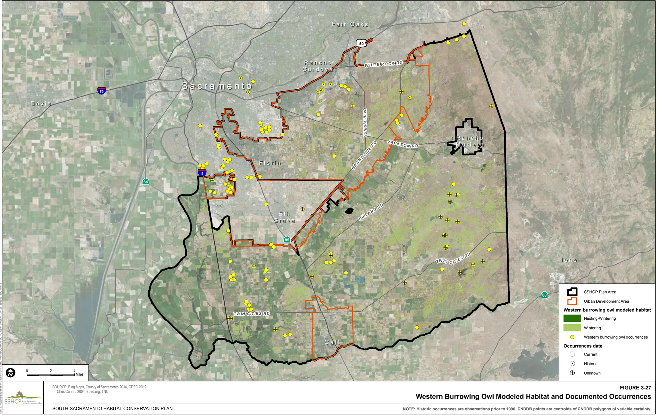
Land Cover Types Relevant to Habitat Requirements
Section titled “Land Cover Types Relevant to Habitat Requirements”SSHCP land cover types that provide suitable habitat for foraging based on life history descriptions include Blue Oak Savanna, Cropland, Irrigated Pasture-Grassland, Valley Grassland, Mixed Riparian Scrub, Vernal Pool, Seasonal Wetland, and Swale. Suitable habitat for nesting include Blue Oak Woodland, Mine Tailing Riparian Woodland, Mixed Riparian Woodland, and Mixed Riparian Scrub (Table 3-2).
Occurrences within the Plan Area
Section titled “Occurrences within the Plan Area”There are 62 documented occurrences of white-tailed kite within the Plan Area. Twenty are within the UDA including two in PPU 1, seven in PPU 2, four in PPU 3, two in PPU 4, one in PPU 8, and four that are not within a PPU. Forty-two are outside the UDA, including five in PPU 5, 34 in PPU 6, and three that are not within a PPU.
Model Assumptions
Section titled “Model Assumptions”- Territory sizes estimated along the south coast of California near Long Beach ranged from 22 to 128 acres (nine to 52 hectares) (Waian 1973) and near San Diego from 42 to 217 acres (17 to 88 hectares) (Henry 1983).
- During winter and the breeding season, Warner and Rudd (1975) found foraging from nest or perch sites extended up to 2 miles, but most were less than 0.6 mile.
- No regularly occurring surveys have been conducted throughout the SSHCP Study Area, however, White-tailed kites are known to nest or forage throughout the Study Area (Conard, pers. comm. 2004).
White-Tailed Kite Habitat Model
Section titled “White-Tailed Kite Habitat Model”Modeled foraging habitat is Blue Oak Savanna, Cropland, Irrigated Pasture-Grassland, Valley Grassland, Mixed Riparian Scrub, Vernal Pool, Seasonal Wetland, and Swale throughout the Plan Area. Modeled nesting habitat is Blue Oak Woodland, Mine Tailing Riparian Woodland, Mixed Riparian Woodland, and Mixed Riparian Scrub throughout the Plan Area.
Figure 3-28 illustrates the location of modeled habitat as well as the documented occurrences of white-tailed kite within the Plan Area.
3.4.6 Mammals
Section titled “3.4.6 Mammals”American Badger (Taxidea taxus)
Section titled “American Badger (Taxidea taxus)”Habitat Requirements
Section titled “Habitat Requirements”American badger occurs in a variety of open habitats, including grasslands, shrublands, savannas, and meadows. The Plan Area is within American badger’s range in California. American badgers have been documented in the northeastern portion of the Plan Area.
Land Cover Types Relevant to Habitat Requirements
Section titled “Land Cover Types Relevant to Habitat Requirements”SSHCP land cover types that provide suitable habitat based on life history descriptions include Blue Oak Savanna, Valley Grassland, Vernal Pool, Seasonal Wetland, and Swale (Table 3-2).
Occurrences within the Plan Area
Section titled “Occurrences within the Plan Area”There are nine documented occurrences of American badger within the Plan Area. Eight are within the UDA, including one in PPU 1 and seven in PPU 2. One occurrence is outside of the UDA in PPU 1.
Model Assumptions
Section titled “Model Assumptions”- Female and male home range sizes in Utah have been estimated at 338-751 acres and 1,327-1,549 acres, respectively (Lindzey 1978). In Idaho, female and male badger home ranges averaged 400 acres and 600 acres, respectively (Messick and Hornocker 1981).
- The SSHCP Study Area is positioned within American badger’s California range; and Badgers have been documented in the northeastern portion of the Plan Area.
- Badgers require large relatively undisturbed areas; therefore, primary habitat occurs in the eastern grasslands and rangelands of the Plan Area.
American Badger Habitat Model
Section titled “American Badger Habitat Model”Modeled habitat is Blue Oak Savanna, Valley Grassland, Vernal Pool, Seasonal Wetland, and Swale within rural portions of the Plan Area.
Figure 3-29 illustrates the location of modeled habitat as well as the documented occurrences of American badger within the Plan Area.
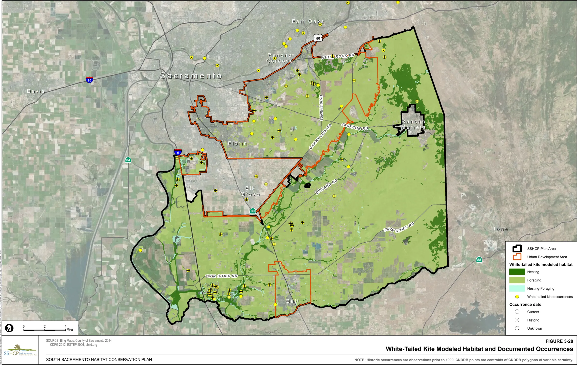
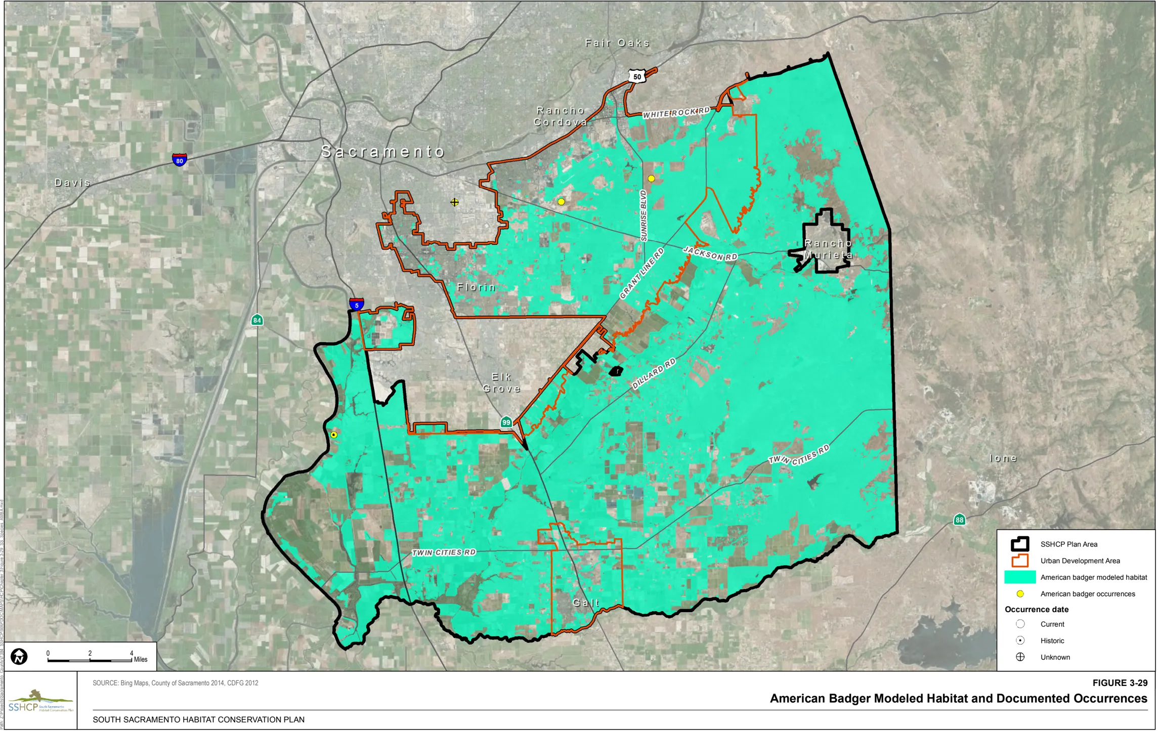
Western Red Bat (Lasiurus blossevillii)
Section titled “Western Red Bat (Lasiurus blossevillii)”Habitat Requirements
Section titled “Habitat Requirements”Western red bat roosts in the foliage of large shrubs and trees in habitats bordering forests, rivers, agricultural areas, and urban areas (Harvey et al. 1999). Roosts are commonly in edge habitats adjacent to streams or open fields, in orchards, and sometimes in urban areas with mature trees (Western Bat Working Group 1998). Pierson et al. (1999) describe roosting habitat as large diameter riparian cottonwoods and sycamores, and older orchard trees (particularly walnuts).
Foraging has been noted in habitats such as mature orchards, oak woodland, low elevation conifer forest, and non-native trees in urban and rural residential areas. In addition, this species may forage in habitats adjacent to streams and rivers that do not provide roosting habitat. Water features are a vital habitat component because bats often drink immediately after emergence and water is an important source of concentrated insects (Johnson, as cited in SSHCP Appendix B).
Land Cover Types Relevant to Habitat Requirements
Section titled “Land Cover Types Relevant to Habitat Requirements”SSHCP land cover types that provide suitable habitat for foraging based on life history descriptions include Valley Grassland, Blue Oak Woodland, Blue Oak Savanna, Orchard, Mine Tailing Riparian Woodland, Mixed Riparian Woodland, Mixed Riparian Scrub, Vernal Pool, Seasonal Wetland, Swale, Freshwater Marsh, Open Water, and Stream/Creek. Suitable habitat for roosting include Blue Oak Woodland, Blue Oak Savanna, Orchard, Mine Tailing Riparian Woodland, and Mixed Riparian Woodland (Table 3-2).
Occurrences within the Plan Area
Section titled “Occurrences within the Plan Area”There are seven documented occurrences of western red bat within the Plan Area. Five are within the UDA including one in PPU 2, one in PPU 8 and three that are not within a PPU. Two occurrences are outside of the UDA including one in PPU 5 and one in PPU 7.
Model Assumptions
Section titled “Model Assumptions”- Data regarding reported territory sizes and distances traveled between roosting and foraging sites is not available.
- Fifty-six records for the western red bat (1977 to 2002) varied in location precision from ‘Sacramento County’ to ‘Sacramento’ to an actual address. Over 30 western red bats were from localities reported as the City of Sacramento, Folsom, Rancho Cordova, Wilton, Elk Grove, and Galt (Constantine, unpubl. data 2004).
Western Red Bat Habitat Model
Section titled “Western Red Bat Habitat Model”Modeled foraging habitat is Valley Grassland, Blue Oak Woodland, Blue Oak Savanna, Orchard, Mine Tailing Riparian Woodland, Mixed Riparian Woodland, Mixed Riparian Scrub, Vernal Pool, Seasonal Wetland, Swale, Freshwater Marsh, Open Water, and Stream/Creek throughout the Plan Area. Modeled roosting habitat is Blue Oak Woodland, Blue Oak Savanna, Orchard, Mine Tailing Riparian Woodland, and Mixed Riparian Woodland throughout the Plan Area.
Figure 3-30 illustrates the location of modeled habitat as well as the documented occurrences of western red bat within the Plan Area.
3.5 Existing Preserves in the Plan Area
Section titled “3.5 Existing Preserves in the Plan Area”The Plan Area includes several established existing Preserves both inside and outside of the UDA. Existing Preserves within the Plan Area totals approximately 64,500 acres and includes wildlife refuges, nature preserves, lands under conservation easements, conservation/mitigation banks, and individual project mitigation sites. Of the approximately 64,500 acres of existing Preserve, approximately 3,170 acres are inside the UDA and about 61,330 acres are outside the UDA (Figure 3-40).
The largest grouping of existing Preserves inside the UDA occurs in the Sacramento Valley Vernal Pool Prairie Preserve area located south of Jackson Highway between Excelsior and Eagles Nest roads north of Grant Line Road in PPU 3. The Preserve area includes lands under conservation easement or owned by the Sacramento Valley Conservancy, two conservation or mitigation banks: Arroyo Seco, Bryte Ranch, and other mitigation sites. Other sites with permanent conservation easements are scattered throughout the UDA, with concentrations occurring along northern Laguna Creek, sites within the City of Rancho Cordova, at the Sacramento Regional County Sanitation District Bufferlands and at the Keifer Landfill Bufferlands. Preserved lands at the Sacramento Regional County Sanitation District Bufferlands are on termed easements.
Outside of the UDA, significant Preserves and conservation banks are established west of Interstate 5 (PPU 6), within the Cosumnes River floodplain (PPU 6), and in eastern Sacramento County (PPU 7). Major Preserves larger than 500 acres include the Stone Lakes National Wildlife Refuge, Deer Creek Hills, Chance Ranch, Borden Ranch, Snyder Preserve, Clay Station Conservation Bank, Laguna Terrace Conservation Bank, Gill Ranch Conservation Bank, Elliot mitigation site, Delta Meadows, Sacramento Municipal Utilities District (SMUD) mitigation site, and the Cosumnes River Preserve. Smaller conservation sites are distributed within the Cosumnes River and Deer Creek corridor, eastern Sacramento County grasslands, and agricultural lands west of State Route 99. In addition to established Preserves, the conservation network outside of the UDA includes conservation/mitigation banks with available conservation credits approved by USFWS and the U.S. Army Corps of Engineers.
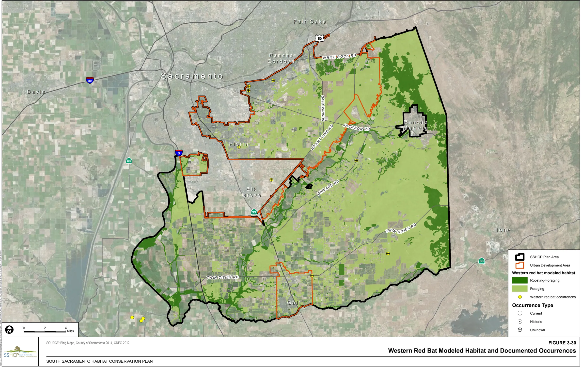
Because existing Preserves generally are located in areas with high resource value, they will provide important existing ‘building blocks’ that the SSHCP Plan Permittees considered during the development of the SSHCP Conservation Strategy, including the proposed SSHCP Preserve System. As discussed in Chapter 7, the SSHCP Conservation Strategy supplements, complements, and links together the existing Preserves by establishing new SSHCP Preserves adjacent to these existing Preserves. Although the Implementing Entity will use existing Preserves to build from, the SSHCP does not count acres of existing Preserves toward achieving the SSHCP Biological Goals and Objectives, and the SSHCP does not seek conservation ‘credits’ for the existing Preserves. Nonetheless, the existing Preserves have conserved resources within the Plan Area, and help to inform the development of the SSHCP conservation strategy by providing building blocks from which the SSHCP Preserve System can grow.
3.6 SSHCP Covered Species Critical Habitat
Section titled “3.6 SSHCP Covered Species Critical Habitat”Federal Critical Habitat has been designated for six of the SSHCP Covered Species: vernal pool species (slender Orcutt grass, Sacramento Orcutt grass, vernal pool fairy shrimp, and vernal pool tadpole shrimp), valley elderberry longhorn beetle, and California tiger salamander.
On August 11, 2005, the USFWS designated Critical Habitat units for four vernal pool crustaceans and 11 vernal pool species, including slender Orcutt grass, Sacramento Orcutt grass, vernal pool fairy shrimp, and vernal pool tadpole shrimp. On February 10, 2006, USFWS identified Critical Habitat units for each individual species identified in the 2005 final rule: 597,821 total acres of Critical Habitat for vernal pool fairy shrimp, 228,785 total acres of Critical Habitat for vernal pool tadpole shrimp, 33,273 total acres of Critical Habitat for Sacramento Orcutt grass, and 94,213 total acres of Critical Habitat for slender Orcutt grass (USFWS 2006).
3.6.1 Slender Orcutt Grass and Sacramento Orcutt Grass
Section titled “3.6.1 Slender Orcutt Grass and Sacramento Orcutt Grass”USFWS has designated 33,273 acres of Critical Habitat for Sacramento Orcutt grass, and 94,213 acres of Critical Habitat for slender Orcutt grass (USFWS 2006).
Within the Plan Area, PPU 2 includes 527 acres of Critical Habitat for both slender Orcutt grass and Sacramento Orcutt grass. PPU 7 includes 9,587 acres of Critical Habitat for just Sacramento Orcutt grass. Of the 9,587 acres of Critical Habitat for Sacramento Orcutt grass within PPU 7, 4,444 acres occur within existing Preserves.
The primary constituent elements of Critical Habitat for Sacramento Orcutt grass (Orcuttia viscida) and slender Orcutt grass (Orcuttia tenuis) are as follows:
-
Topographic features characterized by isolated mound and intermound complex within a matrix of surrounding uplands that result in continuously, or intermittently, flowing surface water in the depressional features including swales connecting the pools described in paragraph (c)(12)(ii) of this section, providing for dispersal and promoting hydroperiods of adequate length in the pools; and
-
Depressional features including isolated vernal pools with underlying restrictive soil layers that become inundated during winter rains and that continuously hold water or whose soils are saturated for a period long enough to promote germination, flowering, and seed production of predominantly annual native wetland species and typically exclude both native and non-native upland plant species in all but the driest years. As these features are inundated on a seasonal basis, they do not promote the development of obligate wetland vegetation habitats typical of permanently flooded emergent wetlands.
3.6.2 Vernal Pool Fairy Shrimp and Vernal Pool Tadpole Shrimp
Section titled “3.6.2 Vernal Pool Fairy Shrimp and Vernal Pool Tadpole Shrimp”As discussed above, USFWS designated 597,821 acres of Critical Habitat for vernal pool fairy shrimp and 228,785 acres of Critical Habitat for vernal pool tadpole shrimp (USFWS 2006).
Within the Plan Area, Critical Habitat for vernal pool fairy shrimp (13-Mather Unit, 14A and 14B-Cosumnes Unit) and vernal pool tadpole shrimp (8-Mather Unit, 9A and 9B-Cosumnes Unit) overlaps exactly and include 1,204 acres in PPU 2, 29,534 acres in PPU 7, and less than 0.1 acre in PPU 5. Of the 1,204 acres of Critical Habitat for within PPU 2, 7.3 acres of Critical Habitat occur within existing Preserves. Of the 29,534 acres of Critical Habitat within PPU 7, 13,223 acres of Critical Habitat occur within existing Preserves.
USFWS (2006) described the primary constituent elements for vernal pool fairy shrimp (Branchinecta lynchi) and vernal pool tadpole shrimp (Lepidurus packardi) as follows:
- Topographic features characterized by mounds, swales, and depressions within a matrix of surrounding uplands that result in complexes of continuously, or intermittently, flowing surface water in the swales connecting vernal pools, providing for dispersal and promoting hydroperiods of adequate length in the pools.
- Depressional features including isolated vernal pools with underlying restrictive soil layers that become inundated during winter rains and that continuously hold water for a minimum of 18 days, in all but the driest years; thereby providing adequate water for species incubation, maturation, and reproduction. As these features are inundated on a seasonal basis, they do not promote the development of obligate wetland vegetation habitats typical of permanently flooded emergent wetlands.
- Sources of food, expected to be detritus occurring in the pools, contributed by overland flow from the pools’ watershed, or the results of biological processes within the pools themselves, such as single-celled bacteria, algae, and dead organic matter, to provide for feeding.
- Structure within the pools described in paragraph (c)(3)(ii) of this section, consisting of organic and inorganic materials, such as living and dead plants from plant species adapted to seasonally inundated environments, rocks, and other inorganic debris that may be washed, blown, or otherwise transported into the pools, that provide shelter.
3.6.3 Valley Elderberry Longhorn Beetle
Section titled “3.6.3 Valley Elderberry Longhorn Beetle”On August 8, 1980 USFWS published the final rule listing the valley elderberry longhorn beetle as a threatened species, and designating Critical Habitat within two areas within Sacramento. The Critical Habitat was designated in two units: Sacramento Zone and American River Parkway Zone. These two units lie outside the Plan Area and are not considered further in the SSHCP.
3.6.4 California Tiger Salamander
Section titled “3.6.4 California Tiger Salamander”On August 25, 2005, USFWS published the final rule designating Critical Habitat for the central population of the California tiger salamander, within 19 counties in California (USFWS 2005a). The USFWS Critical Habitat designation included 97,045 acres in the Central Valley, 20,293 acres in southern San Joaquin, 68,873 acres in the East Bay, and 12,898 acres in the Central Coast, totaling 199,109 acres.
The Plan Area includes 7,420 acres of California tiger salamander Critical Habitat within PPU 7 (designated as California tiger salamander Critical Habitat unit 3)., USFWS 2005a described the primary constituent elements for the central population of California tiger salamander as follows:
- Standing bodies of fresh water (including natural and created (e.g., stock)) ponds, vernal pools, and other ephemeral or permanent water bodies, which typically support inundation during winter rains and hold water for a minimum of 12 weeks in a year of average rainfall.
- Upland habitats adjacent and accessible to and from breeding ponds that contain small mammal burrows or other underground habitat that California tiger salamander depend on for food, shelter, and protection from the elements and predation.
- Accessible upland dispersal habitat between occupied locations that allow for movement between such sites.
Of the 7,420 acres of Critical Habitat for California tiger salamander within PPU 7, 3,436 acres of Critical Habitat occur within existing Preserves.
3.7 SSHCP Covered Species Recovery Plans
Section titled “3.7 SSHCP Covered Species Recovery Plans”Federal recovery plans have been published for 12 SSHCP Covered Species including Ahart’s dwarf rush, Boggs Lake hedge-hyssop, legenere, pincushion navarretia, slender Orcutt grass, Sacramento Orcutt grass, vernal pool fairy shrimp, mid-valley fairy shrimp, vernal pool tadpole shrimp, western spadefoot, and valley elderberry longhorn beetle. In addition, a draft Recovery Plan has been published for giant gartersnake.
3.7.1 Vernal Pool Species
Section titled “3.7.1 Vernal Pool Species”USFWS published the Recovery Plan for Vernal Pool Ecosystems of California and Southern Oregon in 2005 for 33 species (20 listed species and 13 species of concern), including Ahart’s dwarf rush, Boggs Lake hedge-hyssop, legenere, pincushion navarretia, Sacramento Orcutt grass, slender Orcutt grass, vernal pool fairy shrimp, mid-valley fairy shrimp, vernal pool tadpole shrimp, and western spadefoot (USFWS 2005b). It delineates two large core recovery areas in the Plan Area: (1) the Mather Core Recovery Area located within the UDA; and (2) the Cosumnes/Rancho Seco Core Recovery Area, located outside of the UDA. According to USFWS (2005c), the ‘core areas are the specific sites that are necessary to recover these endangered or threatened species or to conserve sites that are necessary to recover these endangered or threatened species or to conserve the species of concern addressed in this recovery plan.’ USFWS (2005c) also states that ‘the core areas were developed in part using critical habitat boundaries, but the two areas differ in that core areas not included in critical habitat have no legal mandate for protection under the Endangered Species Act and solely rely upon voluntary implementation.’ The Recovery Plan focuses on five elements: (1) habitat protection, (2) adaptive habitat management and monitoring, (3) status surveys, (4) research, and (5) public participation and outreach. The Recovery Plan establishes recovery criteria for these five elements (USFWS 2005b):
- Habitat protection criteria:
- Suitable vernal pool habitat within each prioritized core area for the species is protected.
- Species occurrences distributed across the species' geographic and genetic range are protected. Protection of extreme edges of populations protects the genetic differences that occur there.
- Reintroductions and introductions must be carried out and meet success criteria established in action 2.5.3.7.
- Additional occurrences identified through future site assessments, GIS and other analyses, and status surveys that are determined essential to recovery are protected. Any newly found occurrences may count towards recovery goals if the occurrences are permanently protected as described in this plan.
- Habitat protection results in protection of hydrology essential to vernal pool ecosystem function, and monitoring indicates that hydrology that contributes to population viability has been maintained through at least one multi-year period that includes above average, average, and below average local rainfall as defined above, a multi-year drought, and a minimum of 5 years of post-drought monitoring (see Chapter 3).
Table 3-3 depicts the species-specific recovery criteria for the vernal pool species in the Mather Core Recovery Area. The Mather Core Recovery Area has been designated as Zone 1. 1
Table 3-3 Recovery Criteria for the Mather Core Recovery Area and Cosumnes/Rancho Seco Recovery Area
| Common Name | Percent Occurrences to Protect | Percent Suitable Habitat to Protect in Each Core Recovery Area | Reintroductions/ Introductions | Collection Sources |
|---|---|---|---|---|
| Boggs Lake hedge- hyssop | 80% (to conserve) | Mather Core 95% (to conserve) | Reintroduce to vernal pool regions and soil types from which status surveys indicate species has been extirpated to conserve. | At least one population from each core area. |
| Ahart’s dwarf rush | 100% (to conserve) | Mather Core 95% (to conserve) | Reintroduce to vernal pool regions and soil types from which status surveys indicate species has been extirpated to conserve. | Each population. |
| Legenere | 80% (to conserve) | Mather Core 95% (to conserve) Cosumnes/Rancho Seco 95% (to conserve) | Reintroduce to vernal pool regions and soil types from which status surveys indicate species has been extirpated to conserve. | At least one population from each core area. |
| Slender Orcutt grass | 80% (to delist) | 95% (to delist) | Reintroduce to vernal pool regions and soil types from which status surveys indicate species has been extirpated to delist. | Each vernal pool region. Mather Core Recovery Area contains small populations or few occurrences and should be a first source for seedbanking. |
| Sacramento Orcutt grass | 100% (to delist/ downlist) | Mather Core 95% (to downlist) 100% (to delist) Cosumnes/Rancho Seco 95% (to downlist) 100% (to delist) | Reintroduce to appropriate soils in the Orangevale- Folsom area and Rancho Seco area to replace extirpated occurrences. Additional populations must be discovered or established in order to delist. | Each population. |
| Vernal pool fairy shrimp | 80% (to delist) | Mather Core 85% (to delist) Cosumnes/Rancho Seco 85% (to delist) | Reintroduce to vernal pool regions and soil types from which status surveys indicate species has been extirpated to delist. | Not given. |
| Mid-valley fairy shrimp | 80% (to delist) | Mather Core 95% (to conserve) Cosumnes/Rancho Seco 95% (to conserve) | Not given. | Not given. |
| Vernal tadpole shrimp | 80% (to downlist) 100% of re- introduced populations (to delist) | Mather Core 95% (to downlist) Cosumnes/Rancho Seco 95% (to downlist) | Reintroduce to vernal pool regions and soil types from which status surveys indicate species has been extirpated to delist. | Not given. |
| Western spadefoot | 80% (where it co- occurs with other vernal pool species) (to conserve) | Mather Core 85% (to conserve) Cosumnes/Rancho Seco 95% (to conserve) | Not given. | Not given. |
- Adaptive habitat management and monitoring criteria:
- Habitat management and monitoring plans that facilitate maintenance of vernal pool ecosystem function and population viability have been developed and implemented for all habitat protected in (1) A through E above. Plans must be developed and implemented within 5 years of protection of individual parcels/properties/areas to ensure that populations are stable or increasing and progress toward reaching recovery goals is being made while additional habitat protections are being developed. Plans must include provisions for managing non-native and native competitors, appropriate grazing, fire or other management regimes, adaptive habitat management, incorporation of new information resulting from implementation of research actions, and addressing site-specific threats.
- Mechanisms are in place to provide for management in perpetuity and long-term monitoring of (1) A through E above (e.g., funding, personnel).
- Monitoring indicates ecosystem function has been maintained in the areas protected under (1) A through D for at least one multi-year period that includes above average, average, and below average local rainfall as defined above, a multi-year drought, and a minimum of 5 years of post-drought monitoring.
- Seed banking actions have been completed for species that would require it as insurance against risk of stochastic extirpations or that will require reintroductions or introductions to contribute to meeting recovery criteria (see Table 3-3).
-
Status surveys criteria:
- Status surveys, 5-year status reviews, and population monitoring show populations within each vernal pool region where the species occur are viable (e.g., evidence of reproduction and recruitment) and have been maintained (stable or increasing) for at least one multi-year period that includes above average, average, and below average local rainfall as defined above, a multi-year drought, and a minimum of 5 years of post-drought monitoring. (Determining when this criterion is met may rely partly on completion of research actions to model population viability or development of standardized monitoring and survey protocols to determine appropriate parameters to measure during status surveys).
- Status surveys, status reviews, and habitat monitoring show that threats identified during and since the listing process have been ameliorated or eliminated. Site-specific threats identified through standardized site assessments and habitat management planning also must be ameliorated or eliminated (see Chapter 3).
-
Research criteria:
- Research actions necessary for recovery and conservation of the Covered Species have been identified (these are research actions that have not been specifically identified in the recovery actions but for which a process to develop them has been identified). Research actions (both specifically identified in the recovery actions and determined through the process) on species biology and ecology, habitat management and restoration, and methods to eliminate or ameliorate threats have been completed and incorporated into habitat protection, habitat management and monitoring, and species monitoring plans, and refinement of recovery criteria and actions.
- Research on genetic structure has been completed (for species where necessary for reintroduction and introduction, seed banking) and results incorporated into habitat protection plans to ensure that within and among population genetic variation is fully represented by populations protected in Habitat Protection (1) A through E above.
- Research necessary to determine appropriate parameters to measure population viability for each species have been completed (see Chapter 3).
-
Public participation and outreach criteria:
- Recovery Implementation Team is established and functioning to oversee range-wide recovery efforts.
- Vernal Pool Region working groups are established and functioning to oversee regional recovery efforts.
- Participation plans for each Vernal Pool Region have been completed and implemented.
- Vernal Pool Region working groups have developed and implemented outreach and incentive programs that develop partnerships contributing to achieving recovery criteria 1-4 (see Chapter 3).
-
The Recovery Plan indicates that an HCP that addresses the species in the Vernal Pool Recovery Plan may be considered equivalent to the Vernal Pool Recovery Plan if the HCP addresses the six elements described below.
- Permanently protected Vernal Pool Preserves within the area covered by the Habitat Conservation Plan in large contiguous blocks of suitable habitat.
- Protection of the entire genetic range of each listed species within the area covered by the Habitat Conservation Plan.
- Protection of all populations of species with 25 or fewer total occurrences addressed in this plan within the area covered by the Habitat Conservation Plan.
- Connectivity with other Preserves within the area covered by the Habitat Conservation Plan.
- Adaptive management of the Preserves within the area covered by the Habitat Conservation Plan to support the species addressed in this Recovery Plan.
- Sufficient funding for management, maintenance and monitoring of the Preserves in perpetuity.
The recovery criteria for seven of the species listed in Table 3-3 include conservation of 95% of suitable habitat within each the Mather Core Recovery Area. The Plan Permittees recognize that protecting 95% of suitable species habitat in the Mather Core Recovery Area is not feasible because past land use decisions, developments, and agreements, approved by the regulatory agencies since 2005 have already precluded the preservation of that much suitable habitat in the Mather Core Recovery Area. The Recovery Plan does, in item 6 above, however, provide for alternative conservation mechanisms to be used in lieu of the Recovery Plan. One such mechanism is an HCP that takes a comprehensive approach to protecting large interconnected blocks of habitat to protect species (see Chapter 7 for the SSHCP Conservation Strategy).
3.7.2 Giant Gartersnake
Section titled “3.7.2 Giant Gartersnake”USFWS published the Draft Recovery Plan for the Giant Garter Snake (Thamnophis gigas) (USFWS 1999b). The Draft Recovery Plan sets forth recovery criteria for four recovery units in the Central Valley: Sacramento Valley, Mid-Valley, San Joaquin Valley, and South Valley (USFWS 1999b). The goal of the Draft Recovery Plan is to achieve recovery by 2028 and initiate delisting of the giant gartersnake. The SSHCP Plan Area is within the Mid-Valley recovery unit (see Figure 7 of the Draft Recovery Plan) and generally identifies giant gartersnake populations in the ‘Sacramento Area’ (see Table 2 of the Draft Recovery Plan).
The Draft Recovery Plan recovery criteria for giant gartersnake are as follows (USFWS 1999b, p. v):
- Monitoring shows that in 17 out of 20 years, 90% of the subpopulations in the four recovery units contain both adults and young
- All extant populations within the recovery unit are protected from threats that limit populations
- Supporting habitat within the recovery unit is adaptively managed and monitored
- Subpopulations are well connected by corridors of suitable habitat
- Repatriation (reintroduction) has been successful at a specified number of suitable sites
The recovery criteria for the Mid-Valley Recovery Unit are the same as listed above for the entire recovery area, except for ‘b,’ which states that ‘the six existing populations within the recovery unit are protected from threats that limit these populations’ (USFWS 1999b, p. 47).
The Draft Recovery Plan identified six actions needed to achieve the recovery criteria (USFWS 1999b, p. v):
-
Protect existing populations and habitat
-
Restore populations to former habitat
-
Survey to determine species distributions
-
Monitor populations
-
Conduct necessary research, including studies on demographics, population genetics, and habitat use
-
Develop and implement incentive programs, and an outreach and education plan
The Draft Recovery Plan defines a ‘population’ as ‘all the giant gartersnakes within a basin or area (e.g., Colusa Basin, American Basin, Mendota Area’ and a subpopulation as ‘a cluster of locality records in a contiguous habitat area.’ The Sacramento Area, which includes the SSHCP Plan Area, therefore would support a population of giant gartersnake. The SSHCP Plan Area subpopulations would include clusters of occurrences in areas such as Cosumnes River, Morrison Creek, and Laguna Creek.
The Draft Recovery Plan provides more detailed step-down narratives of the six actions, including details for the Mid-Valley Recovery Unit that apply to the Plan Area.
-
Protect known populations of the giant gartersnake.
1.1 Protect populations on private lands.
This action focuses on protecting populations on private lands that are not already under protection by a public or conservation agency through acquisition, easement, or some other mechanism (USFWS 1999b). For the SSHCP Plan Area, the Draft Recovery Plan identifies Task 1.1.9 for the Stone/Beach Lakes area, including the Cosumnes River area (see Table 3 in Draft Recovery Plan). Task 1.1.9 refers to the SSHCP planning efforts, with mitigation on private lands to focus on areas east and west of Interstate 5, acquire lands and restore wetlands south of Lambert Road to connect the giant gartersnake population to the Badger Creek/Willow Creek population, and maintain compatible agricultural practices. These actions are Priority 1 actions in the Draft Recovery Plan, indicating that these actions are needed to prevent extinction or to present the species from declining irreversibly in the foreseeable future (USFWS 1999b).
1.2 Develop or update management recommendations for giant gartersnake habitats.
1.3 Develop, update, and implement management plans for populations on public and conservation lands.
These actions focus on developing or periodically refining management recommendations for ricelands, ditch and canal maintenance, wetlands, and nonaquatic habitats based on new information and incorporating them into management plans for existing public and conservation lands. Where habitat restoration is recommended as part of management, restoration guidelines should be include. Within the SSHCP Plan Area, management recommendations for these actions are included in Table 4 of the Draft Recovery Plan (USFWS 1999b). Task 1.3.5 states that the USFWS and County of Sacramento should incorporate giant gartersnake considerations into management guidelines, build refugia from flooding, and expand habitat at the Stone Lakes NWR. Other protection actions that should generally be implemented and are applicable to the SSHCP include expediting permit approvals for levee repairs to protect adjacent giant gartersnake habitat (1.4), reviewing water efficiency measures (e.g., reduced agriculture runoff) that may conflict with management recommendations for giant gartersnake and its habitat (1.5), assurance of water delivery for giant gartersnake (1.6), and monitoring of existing populations (1.7). -
Surveys for new populations of giant gartersnake.
Action 2.3 includes surveys for giant gartersnake in the Mid-Valley Recovery Unit, especially because it is rapidly urbanizing. Such surveys will help establish appropriate mitigation. -
Re-establish populations of giant gartersnakes to suitable habitat within former range.
Action 3.1 is to identify suitable sites and conduct surveys for repatriation of giant gartersnakes. However, the Draft Recovery Plan does not identify any potential repatriation sites in the Mid-Valley Recovery Unit, so this action does not apply to the SSHCP. -
Conduct necessary research on the giant gartersnake.
This action includes: mark-recapture studies to understand demographics (mortality rates, fecundity, population size) (4.1), genetic studies to determine relatedness of different populations (4.2), radiotelemetry studies (4.3), population viability studies (4.4), developing guidelines for collecting giant gartersnake specimens for research (4.5), buffer/edge effects studies to determine appropriate buffer distances (4.6), studies of contaminant effects such as selenium (4.7), studies of health in selected populations (4.8), studies of effects of introduced predators and development and implementation of a management program (4.9), and studies of how quickly giant gartersnakes colonize new created marsh (4.10). Specific sites for these studies are not identified in the Draft Recovery Plan. -
Develop and implement an outreach and education program.
This action includes: developing guidelines for appropriate land use practices to distribute to landowners and agencies, including ditch and canal maintenance and rodenticide, herbicide and pesticide use (5.1) and developing and distributing informational material to interested parties, including private and public landowners (5.2). Specific sites or areas for outreach and education are not identified in the Draft Recovery Plan. -
Develop and implement economic and other incentives for conservation and recovery on private lands.
This action focuses on creating incentives for landowners to maintain practices that benefit the giant gartersnake, including agricultural incentives (6.1), construction incentives for water districts and users (6.2), and promoting habitat conservation plans that are consistent with the Draft Recovery Plan (6.3).
3.7.3 Valley Elderberry Longhorn Beetle
Section titled “3.7.3 Valley Elderberry Longhorn Beetle”USFWS published the Valley Elderberry Longhorn Beetle Recovery Plan in 1984. The Recovery Plan states that in order to recover the beetle, habitat must be protected along the several rivers, including the American, Sacramento, Feather, Stanislaus, Mokelumne, Calavera, Cosumnes, and San Joaquin. The Mokelumne and Cosumnes Rivers are located in the central and southern portions of the SSHCP Plan Area. The main components of the Valley Elderberry Longhorn Beetle Recovery Plan include: surveys for presence of the valley elderberry longhorn beetle; development of habitat protection plans, restoration of conserved sites (including exotics removal); and management and maintenance, including minimizing the use of herbicides and insecticides, preventing removal of riparian vegetation, and preventing riprapping of habitat sites. The Recovery Plan includes narratives for the following objectives (USFWS 1984).
-
Preserve and protect known habitat sites to provide adequate habitat conditions for valley elderberry longhorn beetle.
The Recovery Plan identified occupied sites along three specific rivers for habitat preservation through long-term administrative actions: American River, Merced River, and Putah Creek (USFWS 1984, p. 22). The Mokelumne and Cosumnes Rivers within the SSHCP Plan Area are not specifically identified for protection in the Recovery Plan. The Recovery Plan has a specific objective (13) for developing management plans for protected sites. -
Survey riparian forests of the Sacramento and San Joaquin Valleys for presence of valley elderberry longhorn beetle and incorporate findings into short-term and long-term management programs.
This objective included surveys along the Mokelumne River from Comanche Reservoir Dam and along the Cosumnes River from Bridgehouse downstream to their confluences with the San Joaquin River. -
Determine ecological requirements and management needs of valley elderberry longhorn beetle.
This objective includes: field studies of the autecology of the species at known and newly discovered sites (31), laboratory studies on life history (32), field studies on potential management needs at certain sites (Goethe Park, Ancil Hoffman Park, American River Parkway, and Solano Lake Park) (33), studies of habitat rehabilitation methods for riparian areas and incorporate results into short- and long-term management programs (34), determination of population status and success of management (35), and determination of delisting criteria.
With the exception of management needs at certain sites, these actions could be conducted throughout the Recovery Plan area. -
Preserve and protect newly discovered valley elderberry longhorn beetle habitat to provide suitable habitat conditions for the species.
This objective includes: minimizing further degradation, development, or modification of habitat (41); protecting newly discovered populations (42); minimizing use of insecticides, herbicides, and other toxic substances (43); and minimizing other activities that are incompatible with habitat maintenance (44). -
Reestablish valley elderberry longhorn beetle at rehabilitated sites within the species’ historical range.
This objective includes: determining suitability of potential existing habitat and rehabilitation sites for reintroduction (51), protecting habitat sites (52), developing and implementing a management program for each site (53), and reintroducing valley elderberry longhorn beetle at selected sites (54). -
Increase public awareness of valley elderberry longhorn beetle through education and information programs.
This objective includes: signage at county parks (61); various audio-visual programs, publications, brochures, and press releases (62); and distribution of information to local parks, schools, newspapers, radio, and television (63). Specific site-specific actions for education are not identified in the Draft Recovery Plan. Also, because the Recovery Plan dates back to 1984, education actions will need to be update to take advantage of current information technologies (e.g., websites, social media). -
Enforce law and regulation to protect valley elderberry longhorn beetle.
This objective includes: informing local agencies about legal status of valley elderberry longhorn beetle, including applicable laws and regulations (71), eliminating illegal collecting (72), and examining the effectiveness of existing laws and regulations and proposing changes as necessary (73).
3.8 SSHCP Preserve Planning Units
Section titled “3.8 SSHCP Preserve Planning Units”To assist with development of an adequate SSHCP Conservation Strategy, the Plan Area was divided into eight PPUs that encompass areas where important Covered Species resources are present, and where habitat preservation will be planned (see Section 1.2.1 and Figure 1-1). These eight SSHCP PPUs are geographic subdivisions of the Plan Area designed to ensure that adequate Biological Goals and Measurable Objectives (see Chapter 7) were developed for all biological resources located within the Plan Area.
PPUs were delineated to capture specific habitat or agricultural land cover types or areas identified as being important for a specific suite of species. For instance, PPU 7, which is located in the southeastern portion of the Plan Area, was delineated to encompass the vast majority of vernal pool grasslands remaining in the County. PPU 7 also contains the designated Cosumnes/Rancho-Seco Core Recovery Area (C/RS) (USFWS 2005b), which is considered an important area for protection of vernal pool species. This section describes the existing conditions within each PPU including natural land cover types and species occurrences within each PPU. Tables 3-4 and 3-5 provide a summary of the existing land cover types within each PPU and Table 3-6 provides a summary of the species occurrences within each PPU.
Table 3-4 Summary of Existing Land Cover Types within the PPUs Inside the UDA (acres)
| Land Cover Type | PPU 1 | PPU 2 | PPU 3 | PPU 4 | PPU 8 | Outside PPUs | Grand Total |
|---|---|---|---|---|---|---|---|
| Valley Grassland (Terrestrial) | 13,377 | 3,589 | 7,072 | 1,168 | 1,488 | 3,650 | 30,344 |
| Blue Oak Savanna (Terrestrial) | 0 | 0 | 18 | 0 | 0 | 0 | 18 |
| Blue Oak Woodland (Terrestrial) | 0 | 0 | 0 | 0 | 0 | 0 | 0 |
| Cropland (Terrestrial) | 359 | 82 | 578 | 1,817 | 1,773 | 872 | 5,481 |
| Orchard (Terrestrial) | 164 | 0 | 13 | 0 | 13 | 22 | 212 |
| Vineyard (Terrestrial) | 15 | 0 | 1,341 | 1 | 19 | 0 | 1,376 |
| Irrigated Pasture-Grassland (Terrestrial) | 6 | 82 | 1,477 | 353 | 1,097 | 203 | 3,218 |
| Vernal Pool (Aquatic) | 389 | 70 | 341 | 21 | 36 | 77 | 934 |
| Swale (Aquatic) | 193 | 40 | 167 | 12 | 7 | 42 | 461 |
| Seasonal Wetland (Aquatic) | 17 | 29 | 8 | 78 | 27 | 3 | 162 |
| Freshwater Marsh (Aquatic) | 19 | 14 | 62 | 266 | 10 | 21 | 392 |
| Mixed Riparian Woodland (Aquatic) | 2 | 0 | 33 | 69 | 114 | 27 | 245 |
| Mixed Riparian Scrub (Aquatic) | 3 | 0 | 18 | 185 | 35 | 1 | 242 |
| Mine Tailing Riparian Woodland (Aquatic) | 220 | 0 | 0 | 0 | 0 | 0 | 220 |
| Stream/Creek (VPIH) (Aquatic) | 35 | 19 | 15 | 0 | 0 | 0 | 69 |
| Stream/Creek (Aquatic) | 14 | 12 | 53 | 11 | 20 | 53 | 163 |
| Open Water (Aquatic) | 83 | 10 | 116 | 10 | 2 | 16 | 237 |
| Aqueducts (Non-Habitat Land Cover Types) | 55 | 69 | 9 | 0 | 0 | 0 | 133 |
| Disturbed (Non-Habitat Land Cover Types) | 551 | 1,426 | 538 | 46 | 87 | 1,213 | 3,861 |
| High Density Development (Non-Habitat Land Cover Types) | 1,158 | 3,180 | 857 | 338 | 986 | 5,143 | 11,662 |
| Low Density Development (Non-Habitat Land Cover Types) | 401 | 239 | 1,312 | 784 | 991 | 1,505 | 5,232 |
| Major Roads (Non-Habitat Land Cover Types) | 157 | 181 | 130 | 90 | 241 | 428 | 1,227 |
| Mine Tailings (Non-Habitat Land Cover Types) | 345 | 0 | 0 | 0 | 0 | 0 | 345 |
| Recreation/Landscaped (Non-Habitat Land Cover Types) | 11 | 227 | 145 | 4 | 187 | 811 | 1,385 |
| Not Mapped (Non-Habitat Land Cover Types) | 0 | 0 | 0 | 0 | 0 | 0 | 0 |
| Grand Total | 17,574 | 71 | 14,303 | 5,253 | 2 | 5 | 67,618 |
Table 3-5 Summary of Existing Land Cover Types within the PPUs Outside the UDA (acres)
| Land Cover Type | PPU 1 | PPU 5 | PPU 6 | PPU 7 | Outside PPUs | Grand Total |
|---|---|---|---|---|---|---|
| Valley Grassland (Terrestrial) | 1,468 | 27,463 | 17,633 | 52,278 | 5,964 | 104,806 |
| Blue Oak Savanna (Terrestrial) | - | 692 | - | 3,080 | 1,847 | 5,619 |
| Blue Oak Woodland (Terrestrial) | - | 5,864 | 11 | 2,781 | 475 | 9,131 |
| Cropland (Terrestrial) | 53 | 2,549 | 39,102 | 4,644 | - | 46,348 |
| Orchard (Terrestrial) | - | 392 | 2,496 | 807 | - | 3,695 |
| Vineyard (Terrestrial) | - | 3,548 | 9,912 | 11,623 | - | 25,083 |
| Irrigated Pasture-Grassland (Terrestrial) | 2 | 2,203 | 6,948 | 3,621 | - | 12,774 |
| Vernal Pool (Aquatic) | 43 | 339 | 944 | 2,221 | 53 | 3,600 |
| Swale (Aquatic) | 11 | 89 | 125 | 531 | 36 | 792 |
| Seasonal Wetland (Aquatic) | - | 446 | 1,636 | 325 | 31 | 2,438 |
| Freshwater Marsh (Aquatic) | - | 159 | 2230 | 170 | 4 | 2,563 |
| Mixed Riparian Woodland (Aquatic) | - | 1,169 | 4,096 | 336 | 11 | 5,612 |
| Mixed Riparian Scrub (Aquatic) | - | 173 | 984 | 53 | 4 | 1,214 |
| Mine Tailing Riparian Woodland (Aquatic) | - | 59 | 17 | 345 | - | 421 |
| Stream/Creek (VPIH) (Aquatic) | 4 | - | - | - | - | 4 |
| Stream/Creek (Aquatic) | 1 | 481 | 1,639 | 432 | 63 | 2,616 |
| Open Water (Aquatic) | 9 | 365 | 1,180 | 528 | 24 | 2,106 |
| Aqueducts (Non-Habitat Land Cover Types) | - | 57 | - | 75 | - | 132 |
| Disturbed (Non-Habitat Land Cover Types) | 531 | 1,396 | 326 | 161 | 12 | 2,426 |
| High Density Development (Non-Habitat Land Cover Types) | - | 122 | 727 | 522 | 42 | 1,413 |
| Low Density Development (Non-Habitat Land Cover Types) | 22 | 4,553 | 3,436 | 5,306 | 60 | 13,377 |
| Major Roads (Non-Habitat Land Cover Types) | 12 | 277 | 863 | 358 | 28 | 1,538 |
| Mine Tailings (Non-Habitat Land Cover Types) | - | 76 | - | 664 | 13 | 753 |
| Recreation/Landscaped (Non-Habitat Land Cover Types) | - | 62 | 108 | 45 | 578 | 793 |
| Not Mapped (Non-Habitat Land Cover Types) | - | - | 784 | - | - | 784 |
| Grand Total | 2,156 | 52,534 | 6 | 90,906 | 9,245 | 250,038 |
Table 3-6 Summary of Covered Species Documented Occurrences in PPUs
| Species | Species Type | PPU 1 | PPU 2 | PPU 3 | PPU 4 | PPU 5 | PPU 6 | PPU 7 | PPU 8 | Outside PPUs | Grand Total |
|---|---|---|---|---|---|---|---|---|---|---|---|
| Ahart’s dwarf rush | Plant | 1 | 1 | - | - | - | - | - | - | - | 2 |
| Boggs Lake hedge-hyssop | Plant | 27 | 1 | 1 | - | - | - | - | - | 2 | 31 |
| Dwarf downingia | Plant | - | - | - | - | - | 8 | 2 | - | - | 10 |
| Legenere | Plant | 20 | 7 | 7 | 1 | 1 | 16 | 9 | - | 1 | 62 |
| Pincushion navarretia | Plant | - | - | - | - | - | - | 48 | - | - | 48 |
| Sacramento Orcutt grass | Plant | 36 | - | 2 | - | - | - | 2 | - | - | 40 |
| Sanford’s arrowhead | Plant | - | 3 | 2 | 1 | 3 | 42 | 3 | - | 10 | 64 |
| Slender Orcutt grass | Plant | 1 | - | 3 | - | - | - | - | - | - | 4 |
| Mid-valley fairy shrimp | Invertebrate | - | 10 | 9 | - | - | 9 | 6 | 2 | 1 | 37 |
| Ricksecker’s water scavenger beetle | Invertebrate | - | 4 | - | - | - | 1 | 3 | - | - | 8 |
| Valley elderberry longhorn beetle | Invertebrate | 1 | - | - | - | 154 | 1 | - | - | - | 156 |
| Vernal pool fairy shrimp | Invertebrate | 56 | 48 | 95 | 4 | 11 | 26 | 324 | 1 | 16 | 581 |
| vernal pool tadpole shrimp | Invertebrate | 308 | 145 | 147 | 6 | - | 26 | 194 | 4 | 21 | 851 |
| California tiger salamander | Amphibian | - | - | - | - | - | - | 29 | 2 | - | 31 |
| Western spadefoot | Amphibian | 7 | 12 | 1 | - | 2 | - | 19 | - | - | 41 |
| Giant gartersnake | Reptile | - | - | - | 2 | - | 11 | 1 | - | - | 14 |
| Western pond turtle | Reptile | - | 2 | - | 1 | 1 | 7 | 8 | - | - | 19 |
| Burrowing owl | Bird | 5 | 16 | 2 | 12 | 1 | 30 | 23 | - | 8 | 97 |
| Cooper’s hawk | Bird | 1 | 2 | 1 | 2 | 2 | 8 | 2 | - | 2 | 20 |
| Ferruginous hawk | Bird | - | 7 | - | 1 | 6 | 4 | 7 | - | 1 | 26 |
| Loggerhead shrike | Bird | 2 | 1 | 2 | 1 | 3 | 15 | 7 | 1 | 2 | 34 |
| Northern harrier | Bird | 4 | 2 | 2 | 2 | 5 | 42 | 7 | 2 | 4 | 70 |
| Greater sandhill crane | Bird | 1 | - | - | 1 | - | 191 | 11 | 6 | - | 210 |
| Swainson’s hawk | Bird | 10 | 5 | 8 | 17 | 35 | 284 | 28 | 20 | 3 | 410 |
| Tricolored blackbird | Bird | - | 3 | 15 | 1 | 3 | 4 | 5 | - | 5 | 36 |
| White-tailed kite | Bird | 2 | 7 | 4 | 2 | 5 | 34 | - | 1 | 7 | 62 |
| American badger | Mammal | 1 | 7 | - | - | - | 1 | - | - | - | 9 |
| Western red bat | Mammal | - | 1 | - | - | 1 | - | 1 | 1 | 3 | 7 |
Inside UDA Preserve Planning Units
Section titled “Inside UDA Preserve Planning Units”PPU 1 encompasses approximately 19,729 acres located in the northern portion of the Plan Area of which about 17,573 acres are inside the UDA (see Figure 3-31). Although the large majority of PPU 1 is inside the UDA, about 2,156 acres of PPU 1 lie outside the UDA (see section describing Outside Preserve Planning Units below). PPU 1 is bordered by U.S. Highway 50 to the north, Prairie City Road to the northeast, the Deer Creek floodplain boundary to the southeast, Sloughhouse to the south, and Sunrise Boulevard to the west. The following describes that portion of the UDA that is within the UDA.
The dominant land cover in PPU 1 is Valley Grassland, which comprises approximately 13,378 acres of the unit. PPU 1 also contains the greatest amount of Vernal Pool (approximately 289 acres) and Swale (approximately 193 acres) acreage of any PPU within the UDA, making it an important PPU for preservation of vernal pool species. Some urbanization has already occurred in this PPU, south of U.S. Highway 50 and east of Sunrise Boulevard, with high-density development comprising approximately 1,158 acres of the unit. PPU 1 encompasses the City of Rancho Cordova in the Plan Area, as well as lands east of Rancho Cordova in unincorporated areas of the County. There are two Preserves within PPU 1 encompassing approximately 680 acres. They include the Sunrise-Douglas Conservation Bank and the Montolina Preserve. PPU 1 also contains 15,827 acres of the 24,245 acre Mather Core Recovery Area (USFWS 2005b).
Species with documented occurrences within PPU 1 include Ahart’s dwarf rush, Boggs Lake hedgehyssop, legenere, Sacramento Orcutt grass, slender Orcutt grass, valley elderberry longhorn beetle, vernal pool fairy shrimp, vernal pool tadpole shrimp, western spadefoot, American badger, and all of the bird Covered Species except ferruginous hawk and loggerhead shrike.
PPU 2 encompasses approximately 9,271 acres and is located in the northern portion of the Plan Area (Figure 3-32). PPU 2 is bordered on the north by U.S. Highway 50, on the east by Sunrise Boulevard, on the south by Jackson Highway, and on the west by Bradshaw Road.
A substantial portion of PPU 2 is developed, including Mather Field and urban development directly north and southeast of the airport. PPU 2 includes 3,180 acres of high-density development, 239 acres of low density development, and 1,426 acres of disturbed land covers. PPU 2 also includes 3,589 acres of Valley Grassland with 70 acres of Vernal Pool and 40 acres of Swale. There is approximately 30 acres of existing Preserve within PPU 2. PPU 2 also contains 3,081 acres of the 24,245 acre Mather Core Recovery Area (USFWS 2005b); all of Slender Orcutt Grass Critical Habitat Unit 6 (1,160 acres); all of Sacramento Orcutt Grass Critical Habitat Unit 2 (1,160 acres); all of Vernal Pool Fairy Shrimp Critical Habitat Unit 13 (2,450 acres); and all of Vernal Pool Tadpole Shrimp Critical Habitat Unit 8 (2,450 acres).
PPU 2 contains documented occurrences for many of the Covered Species, including occurrences of Ahart’s dwarf rush, Boggs Lake hedge-hyssop, legenere, Sanford’s arrowhead, mid-valley fairy shrimp, Ricksecker’s water scavenger beetle, vernal pool fairy shrimp, vernal pool tadpole shrimp, western spadefoot, western pond turtle, American badger, western red bat and all of the bird Covered Species except greater sandhill crane.
PPU 3 encompasses approximately 14,303 acres located in the northwestern portion of the Plan Area (Figure 3-33). PPU 3 is bordered by Jackson Highway on the north, by Sunrise Boulevard on the east, by the Deer Creek and the Cosumnes River floodplain boundary on the south, the Central California Traction railroad line on the southeast, and by Bradshaw Road on the west.
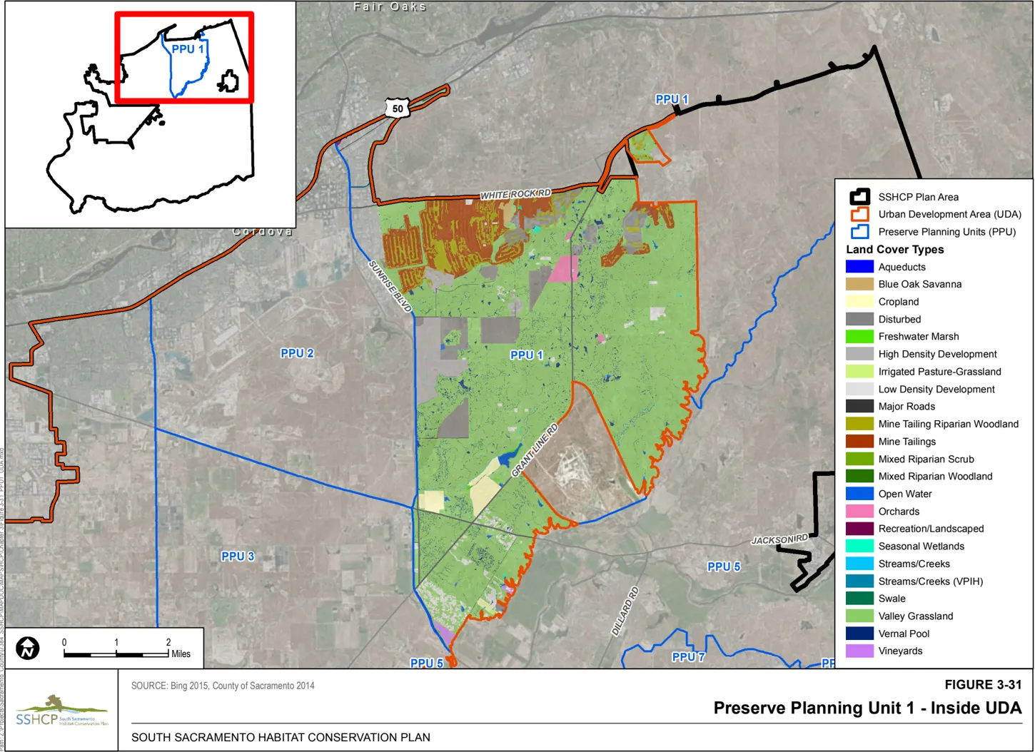
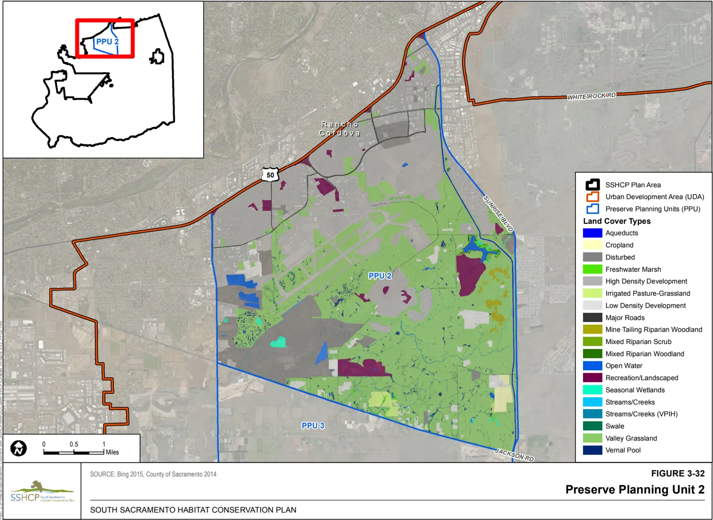
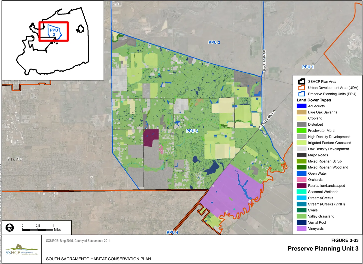
The dominant land cover in PPU 3 is Valley Grassland, which makes up about 7,072 acres of the Unit. Valley Grassland supports about 341 acres of Vernal Pool and about 167 acres of Swale, making this unit particularly important for vernal pool species. PPU 3 contains substantial urban development with high- and low-density development together totaling about 2,169 acres of the unit. PPU 3 also contains substantial agriculture (Cropland, Irrigated Pasture-Grassland, Orchard, and Vineyard), totaling about 3,409 acres of the unit. Existing Preserve in PPU 3 totals approximately 2,200 acres. Most of the Preserve acres are located within the Vernal Pool Prairie Preserve Area, and includes several mitigation sites (e.g. Klotz Preserve, Were Preserve, Cook Preserve) and two conservation banks (Arroyo Seco Conservation Bank and Bryte Ranch Conservation Bank). This unit also contains Preserves established to protect Laguna Creek. PPU 3 also contains approximately 4,574 acres of the 24,245 acre Mather Core Recovery Area (USFWS 2005b).
PPU 3 contains documented occurrences for many of the Covered Species, including occurrences of Boggs Lake hedge-hyssop, legenere, Sacramento Orcutt grass, Sanford’s arrowhead, slender Orcutt grass, mid-valley fairy shrimp, vernal pool fairy shrimp, vernal pool tadpole shrimp, western spadefoot, and all of the bird Covered Species except ferruginous hawk and greater sandhill crane.
PPU 4 encompasses approximately 5,253 acres and is located in the northwestern portion of the Plan Area (Figure 3-34). PPU 4 includes three disjunct areas that are within the UDA. These areas are physically separated from other locations within the UDA by the City of Elk, which is not participating in the Plan. PPU 4 is generally bordered by the Sacramento City limits to the north, Highway 99 to the east, Eschinger Road to the south and Interstate 5 to the west.
The dominant land cover in PPU 4 is Cropland, which occupies about 1,817 acres. PPU 4 also includes about 1,168 acres of Valley Grassland. There are no existing Preserves within PPU 4.
PPU 4 contains documented occurrences for many of the Covered Species, including legenere, Sanford’s arrowhead, vernal pool fairy shrimp, vernal pool tadpole shrimp, giant gartersnake, western pond turtle, and all of the bird Covered Species.
PPU 8 encompasses approximately 7,132 acres and is located in the southern portion of the Plan Area. PPU 8 is entirely within Galt’s sphere of influence (Figure 3-35). PPU 8 is bordered by the northern boundary of Galt’s sphere of influence to the north, Cherokee Lane to the east, Dry Creek to the south and Sargent Avenue to the west.
PPU 8 is dominated by farmland land cover types, including about 1,773 acres of Cropland and 1,097 acres of Irrigated Pasture-Grassland. Other significant cover types within PPU 8 include approximately 1,488 acres of Valley Grassland and 986 acres of high density development and 1,097 acres of low density development. There is approximately 95 acres of existing Preserve within PPU 2 located mainly along Dry Creek and Deadman Gulch.
PPU 8 contains documented occurrences for several of the Covered Species, but does not support significant occurrence concentrations for any particular species with the exception of Swainson’s hawk and greater sandhill crane.
Outside UDA Preserve Planning Units
Section titled “Outside UDA Preserve Planning Units”PPU 1 includes approximately 2,156 acres that are outside the UDA boundary (Figure 3-36). PPU 1 outside of the UDA is dominated by Valley Grassland (about 1,468 acres) and disturbed land cover (531 acres) associated with the Kiefer Landfill. There is approximately 500 acres of existing Preserve within PPU 1 including the Kiefer Landfill Preserve south of and adjacent to the UDA boundary at Grant Line Road.
PPU 1 outside of the UDA contains documented occurrences for several of the Covered Species, but does not support significant occurrence concentrations for any particular species with the exception of Sacramento Orcutt grass.
PPU 5 encompasses approximately 52,534 acres in the central-eastern portion of the Plan Area outside the UDA (Figure 3-37). PPU 5 is situated between PPU 7 to the south and the UDA part of PPU 1 to the north, and is bordered by the county line to the east. The dominant land cover in PPU 5 is Valley Grassland (about 27,540 acres). PPU 5 also includes approximately 1,169 acres of Mixed Riparian Woodland, making it import for species dependent on riparian land cover types. There are 6,500 acres of existing Preserves in PPU 5, including the Deer Creek Hills Preserve and several smaller, scattered Preserve sites. PPU 5 also contains 243 acres of the 24,245 acre Mather Core Recovery Area (USFWS 2005b).
PPU 5 contains documented occurrences for many of the Covered Species, including occurrences of legenere, vernal pool fairy shrimp, western spadefoot, western pond turtle and all of the bird Covered Species except greater sandhill crane. PPU 5 is most notable for encompassing most of the Plan Area documented occurrences for valley elderberry longhorn beetle clustered in a reach of the Cosumnes River extending approximately 2 miles west of Jackson.
PPU 6 encompasses approximately 95,196 acres located in the southwestern portion of the Plan Area (Figure 3-38). PPU 6 is generally bound on the west by State Highway 160 and the Sacramento River, on the north by Eschinger Road, on the south by the Mokelumne River west and just east of I-5, and by Dry Creek on the south from its confluence with the Mokelumne River to north-south alignment of Sargent Avenue, which defines its southeastern boundary.
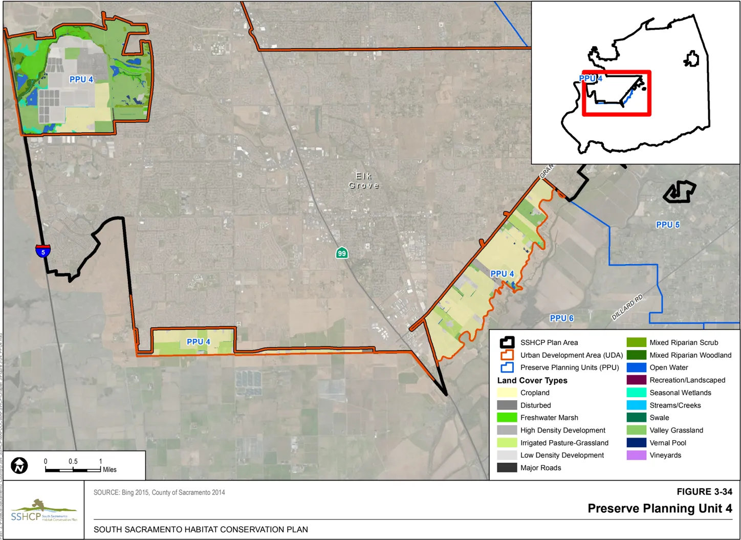
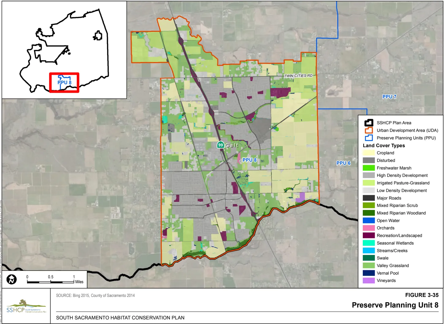
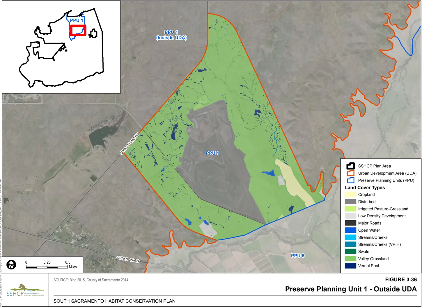
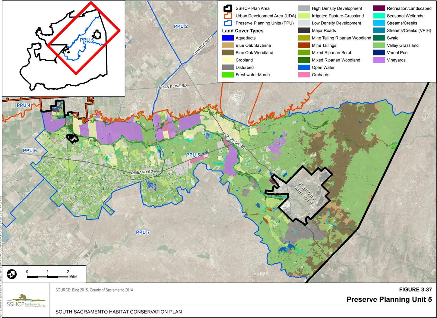
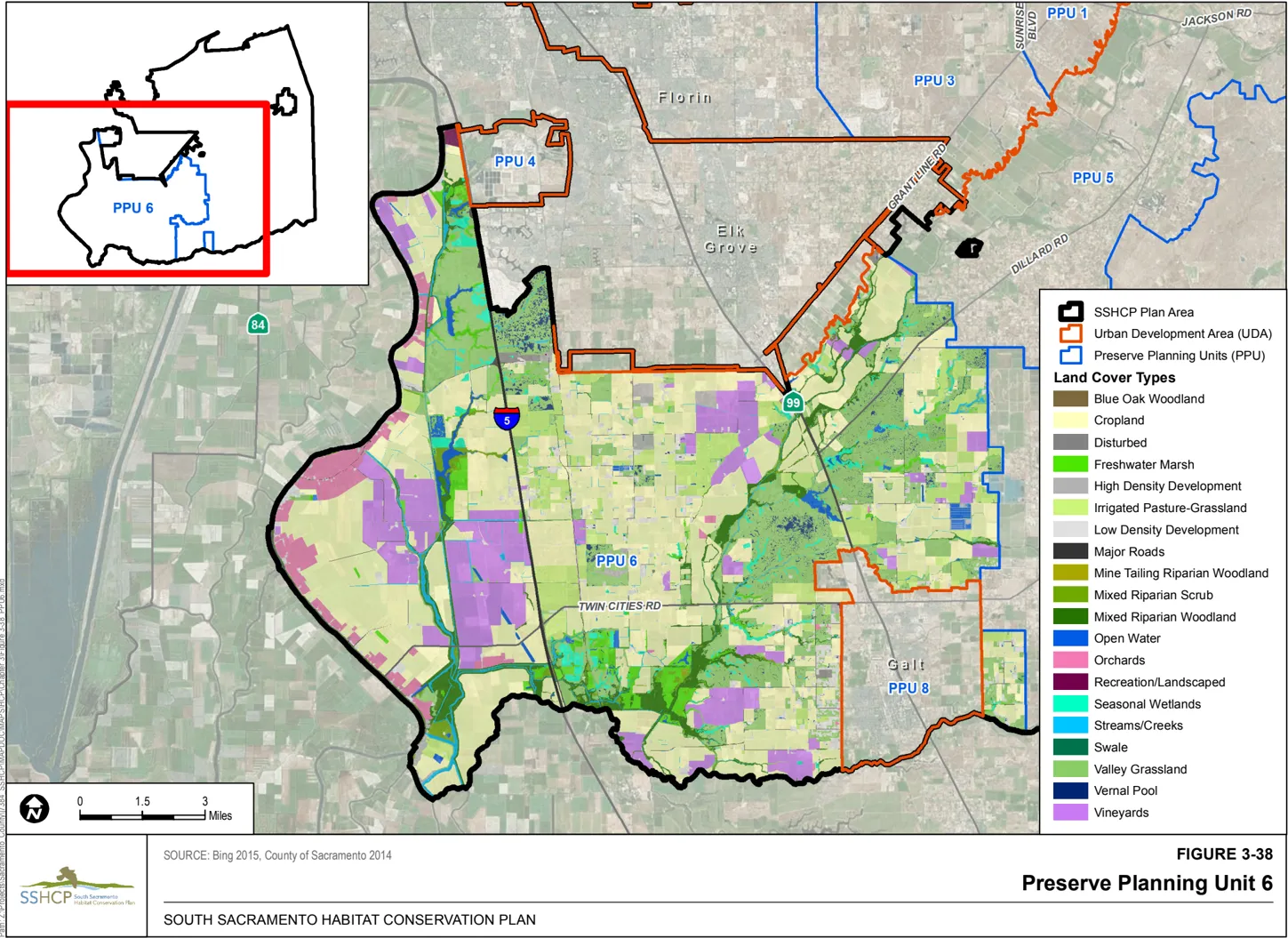
The dominant land covers in PPU 6 are farmland with about 39,102 acres of Cropland, about 6,948 acres of Irrigated Pasture-Grassland about 2,496 acres of Orchard and about 9,912 acres of Vineyard. The unit also contains approximately 17,633 acres of Valley Grassland with about 944 acres of vernal pools. Notably, PPU 6 contains about 4,096 acres of Mixed Riparian Woodland and about 984 acres of Mixed Riparian Scrub. There are approximately 28,000 acres of existing Preserves in PPU 6. A majority of this acreage is part of the Cosumnes River Preserve and the Stone Lakes National Wildlife Refuge.
PPU 6 contains documented occurrences for many of the Covered Species, including occurrences of dwarf downingia, legenere, Sanford’s arrowhead, mid-valley fairy shrimp, Ricksecker’s water scavenger beetle, vernal pool fairy shrimp, vernal pool tadpole shrimp, giant gartersnake and western pond turtle. PPU 6 is most notable for the high number of bird Covered Species that populate this unit. This unit contains all bird Covered Species and an exceptionally high number of documented occurrences for Swainson’s hawk, greater sandhill crane and northern harrier, white-tailed kite and burrowing owl.
PPU 7 encompasses approximately 90,906 acres in the southeastern portion of the Plan Area (Figure 3-39). PPU 7 is bordered by PPU 5 on the north, the county line and Dry Creek to the south, the county line on the east, and the north-south alignments of Cherokee Lane and Davis Road to the west. The dominant land cover in PPU 7 is Valley Grassland, which encompasses 52,278 acres. PPU 7 is most notable for the amount of Vernal Pool (about 2,221 acres) and Swale (531 acres) that it contains. There is also about 11,623 acre of Vineyard within this unit.
There are approximately 26,000 acres of existing Preserves in PPU 7. Preserve in PPU 7 include the Chance Ranch Preserve, Laguna Creek Conservation Bank, Gill Ranch Conservation Bank, Clay Station Conservation Bank, SMUD Preserve and several other smaller Preserve sites. PPU 7 also includes the entire 44,388 acre Rancho Seco Core Recovery Area; the entire California Tiger Salamander Critical Habitat Unit 3 (10,193 acres); the entire Vernal Pool Tadpole Shrimp Critical Habitat Unit 9A (96 acres); 34,880 acres of the 36,996 acre Vernal Pool Tadpole Shrimp Critical Habitat Unit 9B; 34,880 acres of the 36,996 acre Vernal Pool Fairy Shrimp Critical Habitat Unit 14A; the entire Vernal Pool Fairy Shrimp Critical Habitat Unit 14B (96 acres); and 29,870 acres of the 32,086 acre Sacramento Orcutt Grass Critical Habitat Unit 3.
PPU 7 contains documented occurrences for many of the Covered Species including dwarf downingia, legenere, Sacramento Orcutt grass, Sanford’s arrowhead, mid-valley fairy shrimp, Ricksecker’s water scavenger beetle, vernal pool fairy shrimp, vernal pool tadpole shrimp, western spadefoot, giant gartersnake, western pond turtle, western red bat and all of the bird Covered Species with the exception of the white-tailed kite. Most notable is that this is the only unit with pincushion navarretia and is the most important unit for California tiger salamander.
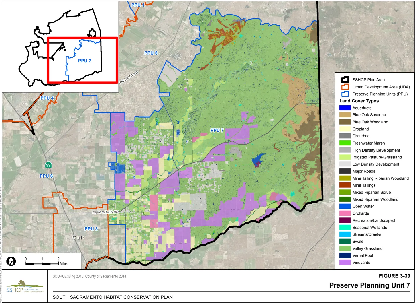
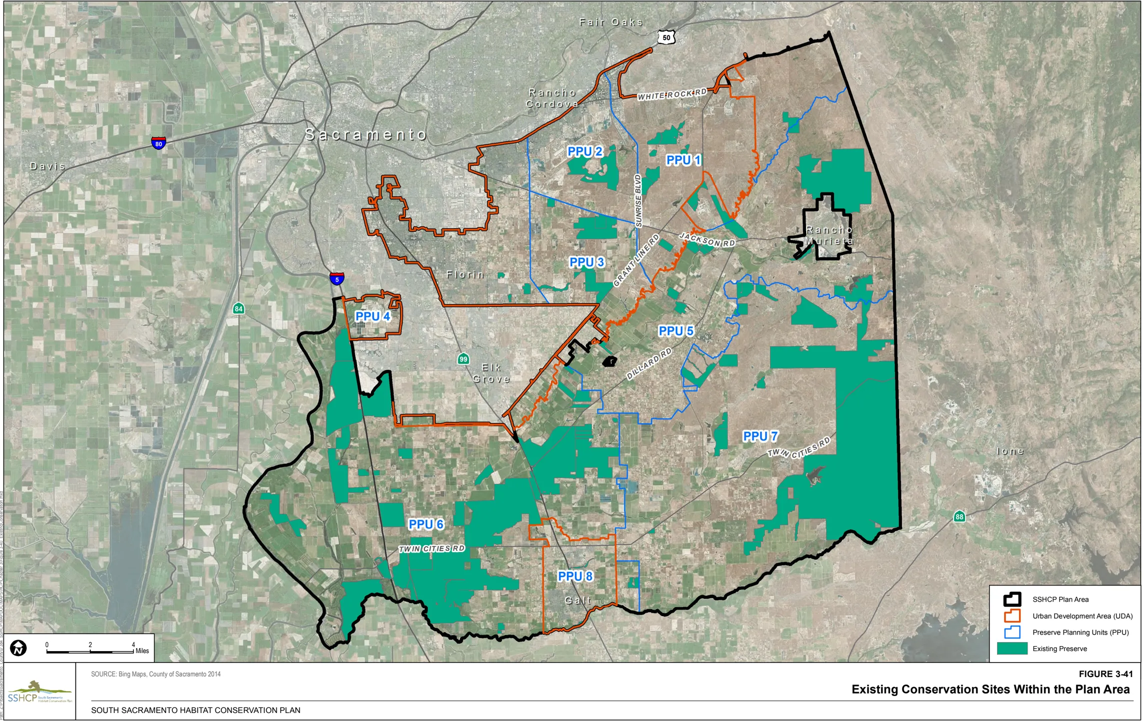
3.9 References Cited
Section titled “3.9 References Cited”-
Adelsbach, T. 2010. Verbal communication from Terry Adelsbach, Senior Biologist of USFWS to R. Radmacher, Senior Planner, County of Sacramento. August 2010.
-
Adelsbach, T. 2013. Verbal communication from Terry Adelsbach, Senior Biologist USFWS, to R. Radmacher, Senior Planner, County of Sacramento. August 8, 2013.
-
Ahart, L. 2003. Thoughts on Juncus leiospermus var. ahartii . Unpublished note given to John Dittes.
-
Alexander, D. G. 1976. Ecological Aspects of Temporary Pool Fauna. In: S. Jain, (ed.). Vernal Pools: Their Ecology and Conservation . Institute of Ecology Publication Number 9. Davis, California.
-
Asay, C.E. 1987. Habitat and productivity of Cooper’s hawks nesting in California. California Fish and Game 73:80-87.
-
Babcock, K.W. 1995. Home range and habitat use of breeding Swainson’s Hawks in the Sacramento Valley of California. Journal of Raptor Research , 29: 193- 197.
-
Barnard, P.E. 1983. Foraging behaviour and endergetcs of Northern Harriers Circus cyaneus (L.). Honor’s thesis, Acadia University, Wolfville, NS.
-
Barr. 1991.
-
Bartgis, R. 1992. Loggerhead Shrike. P. 281-297 in Migratory nongame birds of management concern in the northeast (K. J. Schneider and D. M. Pence, eds.). U.S. Fish and Wildlife Service, Region 5, Newton Corner, MA. Bechard and Schmutz 1995.
-
Beebe, F.L. 1974. Field studies of the Falconiformes of British Columbia. Brit. Col. Prov. Mus. Occas. Paper No. 17. 163 pp.
-
Beedy and Hamilton. 1997.
-
Beedy, E.C. and W.J. Hamilton III. 1999. Tricolored Blackbird (Agelaius tricolor) in A. Poole and F. Gill (eds.), The birds of North America, No. 423. The Birds of North America, Inc., Philadelphia, Pennsylvania.
-
Berry, M.E., C.E. Bock, and S.L. Haire. 1998. Abundance of diurnal raptors on open space grasslands in an urbanized landscape. Condor 100: 601-608.
-
Bloom, P.H. 1980. The status of the Swainson’s hawk in California, 1979. Final Report II-8.0, USDI Bureau Land Management and Federal Aid in Restoration, Project. W-54-R-12, California Department of Fish and Game, Sacramento, California.
-
Bobzien, S. 2003. East Bay Regional Park District Comments to the USFWS for the listing of the Central California Distinct Population Segment of the California tiger salamander (Ambystoma californiense). Proposed Rule.
-
Boyer, D. R. 1965. Ecology of the basking habitat in turtles. Ecology 46:99-118.
-
Brode, J. 1988. Natural history of the Giant Garter Snake (Thamnophis couchii gigas). Pages 2528, In Proceedings of the conference on California herpetology, H.F. DeListe, P.R. Brown, B. Kaufman, and B.M. McGurty (eds). Southwestern Herpetologists Society, Special Publication No. 4.
-
Butts, K.O. 1973. Life history and habitat requirements of Burrowing Owls in western Oklahoma. Master’s thesis, Oklahoma State University, Stillwater. 188 pp.
-
Cade and Woods. 1997.
-
CBD (Center for Biological Diversity), Santa Clara Valley Audubon Society, Defenders of Wildlife, San Bernardino Valley Audubon Society, California State Park Rangers Association and Tri-County Conservation League. 2003. Petition to the State of California Fish and Game Commission and Supporting Information for Listing the California Population of the Western Burrowing Owl (Athene cunicularia hypugaea) as an Endangered or Threatened Species Under the California Endangered Species Act. Submitted April 7.
-
CDFG (California Department of Fish and Game). 2002. California Natural Diversity Database CNDDB). Rarefind. Sacramento, California: CDFG, Wildlife and Habitat Data Analysis Branch.
-
CDFG. 2003. ‘California Tiger Salamander.’ CNDDB. Sacramento, California: CDFG, Wildlife and Habitat Data Analysis Branch.
-
CDFG. 2010. Legenere. CNDDB. Rarefind Version 3.1.1. Commercial version dated February 28, 2010. Sacramento, California: CDFG, Wildlife and Habitat Data Analysis Branch.
-
CNPS (California Native Plant Society). 2001. Inventory of Rare and Endangered Plants of California . 6th ed. Rare Plant Scientific Advisory Committee, David P. Tibor, Convening Editor. Sacramento, California: CNPS.
-
CNPS. 2010. Inventory of Rare and Endangered Plants . Online ed. Version 7-10b. Sacramento, California: CNPS. Accessed April 27, 2010. http://www.cnps.org/inventory.
-
Collins CT and RE Landry. 1977. ‘Artificial Nest Burrows for Burrowing Owls.’ North American Bird Bander 2:151-154.
-
Conard, C. 2004. Verbal communication from Chris Conard, Ornithologist. Sacramento Regional Wastewater Treatment Plant - Bufferlands. Elk Grove, CA to Todd Sloat of Todd Sloat Biological Consulting Inc. October 15, 2004.
-
Constantine, D.G. 1959. ‘Ecological observations on lasiurine bats in the north bay area of California.’ Journal of Mammalogy 40(1):13-15.
-
Cook, L. 1999. ‘Tricolored Blackbird (Agelaius tricolor) conservation plan for southern Sacramento County.’ Unpublished report submitted to Jones & Stokes, in cooperation with the southern Sacramento County Habitat Conservation Plan.
-
Coulombe, H.N. 1971. Behavior and population ecology of the burrowing owl, Speotyto cunicularia , in the Imperial Valley of California. Condor 73:162-176.
-
Crampton, B. 1959. The grass genera Orcuttia and Neostapfia : A study in habitat and morphological specialization. Madrono 15 pp. 97-110.
-
DeHaven, R.W. 2000. Tricolored Blackbird discussion modified for outside FWS use-for typical HCP development. Unpublished report, U.S. Fish and Wildlife Service, Sacramento, California.
-
DeHaven, R.W. 1975. Plumages of the Tricolored Blackbird. Western Bird Bander, 50:59-61.
-
Dittes, J. C., and J. L. Guardino. 2001. Chapter 3: Rare Plants. In Vollmar J. E. (ed.) 2002. Wildlife and Rare Plant Ecology of Eastern Merced County’s Vernal Pool Grasslands. Vollmar Consulting, Berkeley, California.
-
Dixon, J.B., R.E. Dixon, and J. E. Dixon. 1957. Natural history of the White-tailed Kite in San Diego County, California. Condor 59: 156-165.
-
Dunk, J.R. 1995. White-Tailed Kite (Elanus leucurus). In The Birds of North America Online , edited by A. Poole. Ithaca, New York: Cornell Lab of Ornithology. Accessed November 29, 2011. doi: 10.2173/bna.178.
-
Ebird.org. 2005-2010. Ebird - Bird Observations Mapping Tool Website. Audubon and Cornell Lab of Ornithology. Ithaca, NY. Accessed online http://ebird.org/content/ebird
-
Eng, L.L. 1984. Rare, threatened and endangered invertebrates in California riparian systems. In: California riparian systems ecology, conservation, and productive management. Ed. R.E. Warnter and K.M. Hendrix, Berkeley: University of California Press.
-
Eng, L., D. Belk, and C. Eriksen. 1990 Californian Anostraca: Distribution, Habitat, and Status. Journal of Crustacean Biology 10(2):247-277.
-
Erichsen, A.L., K.S. Smallwood, A.C. Commandatore, B.W. Wilson, and D.M. Fry. 1996. White-tailed Kite Movement and Nesting Patterns in an Agricultural Landscape. In . Raptors in Human Landscapes. D. Bird and J.J. Negro eds. Academic Press, London. pp. 165-175.
-
Erichsen, A.L., K.S. Smallwod, N.D. Ottum, and D.M. Fry. 1994. The white-tailed kite: GIS analysis of habitat selection in the Sacramento Valley, California with implication for Conservation of wildlife in agricultural landscapes. Abstract. Journal of Raptor Research 28(1):46.
-
Eriksen, C. and D. Belk. 1999. Fairy shrimps of California’s pools, puddles, and playas . Mad River Press, Eureka, California.
-
Estep, J.A. 1989. Biology, movements and habitat relationships of the Swainson’s Hawk in the Central Valley of California, 1986-87. Calif. Dept. Fish and Game, Nongame Bird and Mammal Sec. Rep.
-
Estep, J. .2006. The Distribution, Abundance, and Habitat Associations of the Swainson’s Hawk (Buteo swainsoni) in the City of Elk Grove Planning Area. Estep Environmental Consulting, Sacramento, California.
-
Estep, J. 2007. The Distribution, Abundance, and Habitat Associations of the Swainson’s Hawk (Buteo swainsoni) in the City of Rancho Cordova Planning Area. Estep Environmental Consulting, Sacramento, California.
-
Feaver, P.E. 1971. Breeding pool selection and larval mortality of three California amphibians: Ambystoma tigrinum californiense Gray, Hyla regilla Baird and Girard and Scaphiopus hammondi hammondi Girard. Master’s thesis, Department of Biology, Fresno State College, Fresno California. 58pp.
-
Fisher, R.N., and H.B. Shaffer. 1996. The decline of amphibians in California’s Great Central Valley. Conservation Biology 10(5):1387-1397.
-
Fuller, Ken. 2005. Fish and Wildlife Biologist. US Fish and Wildlife Service. Sacramento, CA. March 2005.
-
Gardner, T. 2010. Verbal communication from Todd Gardner of CDFW to R. Radmacher, Senior Planner, County of Sacramento. August 2010.
-
Gervais, J.A., D.K. Rosenberg and R.G. Anthony. 2003. Burrowing Owl space use and pesticide exposure risk. Journal of Wildlife Management 67:155-64.
-
Gifford, D.L., P.S. Hofmann, A.A. Truex, and D.H. Wright. 2012. Monitoring Distribution and Abundance of Nesting Swainson’s Hawks in the Sacramento Valley and Sacramento River Delta, California. California Fish and Game 98(1): 7-18.
-
Gill Ranch Survey. 2003. 135 Gill Ranch Survey, Sacramento County, California.
-
Gleason, R.S. and D.R. Johnson. 1985. Factors influencing nesting success of burrowing owls in southeastern Idaho. Great Basin Naturalist 45: 81-84.
-
Griggs, F.T. 1974. Systematics and ecology of the genus Orcuttia (Gramineae). M.S. Thesis, California State University, Chico, California. 70pp.
-
Grinnell, J. and A.H. Miller. 1944. The Distribution of the Birds of California . Cooper Ornithological Club. Berkeley, California.
-
Gutierrez, R. J., and Walter D. Koenig. 1978. Characteristics of storage trees used by acorn woodpeckers in two California woodlands. J. of For. 76:162-164.
-
Hamilton, W. J. III. 2004. Verbal communication from Professor Hamilton, Division of Environmental Studies, University of California, Davis, California to Todd Sloat of Todd Sloat Biological Consulting Inc. 2004.
-
Hamilton, W.J. III, L. Cook, and R. Grey. 1995. Tricolored Blackbird project 1994. Unpublished report prepared for U.S. Fish and Wildlife Service, Portland, Oregon.
-
Hanes, W.T., B. Hecht, and L. Stromberg. 1990. Water Relationships of Vernal Pools in the Sacramento Region, California. Pages 49-60 in: D. Ikeda and R. A. Schlising (eds.), Vernal Pool Plants, their Habitat and Biology, Studies from the Herbarium, No. 8, CSU Chico, California.
-
Hanes, T., and L. Stromberg. 1998. Hydrology of Vernal Pools on Non-Volcanic Soils in Sacramento Valley. Pages 38-49 in: C.W. Witham et al. (eds.), Ecology, Conservation, and Management of Vernal Pool Ecosystems . CNPS, Sacramento, California.
-
Hansen, R.W. 1980. Western aquatic garter snakes in central California: an ecological and evolutionary perspective. Master’s thesis, Department of Biology, California State University, Fresno. 78 pp.
-
Hansen, G.E. 1988. Review of the status of the GGS (Thamnophis couchi gigas) and its supporting habitat during 1986-1987. Final report for CDFG, Contract C-2060. Unpublished. 31 pp.
-
Hansen G.E., and J.M. Brode. 1993. Results of relocating canal habitat of the GGS (Thamnophis gigas) during widening of State Route 99/70 in Sacramento and Sutter counties, California. Final report for Caltrans Interagency Agreement 03E325 (FG7550) (FY 87/88-91-92). Unpublished. 36 pp.
-
Harlow, D.L., and P.H. Bloom. 1989. Buteos and the golden eagle. Pages 102-110 in B.G. Pendleton, ed. Proceedings of the western raptor management symposium and workshop. National Wildlife Federation Scientific and Technical Series No. 12. Washington, D.C.
-
Harvey, M.J., J.S. Altenbach, and T.L. Best. 1999. Bats of the United States . Arkansas Game and Fish Commission in cooperation with the U.S. Fish and Wildlife Service.
-
Haug, E. A., and L. W. Oliphant. 1987. Breeding biology of Burrowing Owls in Saskatchewan. Pages 269-271 in G. L. Holroyd, P. H. R. Stepney, G. C. Trottier, W. B. McGillivray, D. M. Ealey, and K. E. Eberhart, editors. Endangered species in the prairie provinces. Natural History Occasional Paper No. 9. Provincial Museum of Alberta, Edmonton, Alberta.
-
Hawbecker, A.C. 1942. A life history study of the White-tailed Kite. Condor 44: 267-276.
-
Hays, D.W., K.R. McAllister, S.A. Richardson, and D.W. Stinson. 1999. Washington State Recovery Plan for Western Pond Turtle. Washington Department of Fish and Wildlife, Olympia, Washington.
-
Helm, B. 1998. Biogeography of eight large branchiopods endemic to California. Pp. 124-139 In : Witham, C. W., E. T. Bauder, D. Belk, W. R. Ferrin Jr., and R. Orduff (eds.). Ecology, conservation, and management of vernal pool ecosystems - proceedings from a 1996 conference. California Native Plant Society, Sacramento, California.
-
Vollmar, J.E. (Ed.). 2002. Wildlife and Rare Plant Ecology of Eastern Merced County’s Vernal Pool Grasslands. Vollmar Consulting, Berkeley, California.
-
Henry, M.E. 1983. Home range and territoriality in breeding White-tailed Kites. Master’s thesis, San Diego State Univ., San Diego, California.
-
Holland, R.F. 1986. Preliminary Descriptions of the Terrestrial Natural Communities of California. Nongame-Heritage Program, California Department of Fish and Game. October 1986.
-
Holland, D. 1991. A synopsis of the ecology and status of the western pond turtle ( Clemmys marmorata) in 1991. Unpublished report for the US Fish and Wildlife Service, San Simeon, California.
-
Holland, D.C. 1994. The Western Pond Turtle: Habitat and History. US Department of Energy, Bonneville Power Administration, Portland, Oregon. DOE/BP-62137-1.
-
Holland, R.F. and V.I. Dains. 1990. The edaphic factor in vernal pool vegetation. Pp. 31-48 in: Ikeda, D.H. and R.A. Schlising (Eds.). Vernal Pool Plants: Their Habitat and Biology. Studies from the Herbarium, CSU Chico, California. Number 8.
-
Holland, R. F., and S. Jain. 1988. Vernal Pools. Pages 515-553 in: M.G. Barbour and J. Major (eds.), Terrestrial Vegetation of California , 2nd edition, CNPS, Sacramento, California.
-
Ivey, G. 2004. Verbal communication from Gary Ivey, ornithologist to Todd Sloat of Todd Sloat Biological Consulting Inc. October 2004, January 2005.
-
Ivey, G.L., C.P. Herziger. 2003. Sandhill Crane monitoring at Staten Island, San Joaquin County, California, 2002-03. A survey for The Nature Conservancy, Galt, California.
-
Jennings, M.R. and M.P. Hayes. 1994. Amphibian and reptile species of concern in California. California Department of Fish and Game technical report, Inland Fisheries Division, Rancho Cordova, California.
-
Johnson, H. L. 2000. Roosting and foraging ecology of bats in the Sutter Buttes, Sutter County, California. Unpublished Master’s Thesis, California State University, Sacramento, 114 pp.
-
Jokerst, J. D. 1990. Floristic Analysis of Volcanic Mudflow Vernal Pools. Pages 1-30 in: D. Ikeda and R. A. Schlising (eds.), Vernal Pool Plants, their Habitat and Biology, Studies from the Herbarium, No. 8, CSU Chico, California.
-
Jones, R. 2004. Verbal communication from Roger Jones of the Sacramento Regional Wastewater Treatment Plant - Bufferlands. Elk Grove, CA. to Steve Henderson of Henderson Ecology and Planning. October 2004.
-
Jones and Stokes. 1990. Sacramento County Vernal Pools: Their Distribution, Classification, Ecology, and Management. Prepared for the County of Sacramento, Planning and Community Department, Sacramento, California.
-
Karalus, K. E. and A. W. Eckert. 1987. The owls of North America . Weathervane Books, New York, New York.
-
Keeler-Wolf, T., D.R. Elam, K. Lewis and S.A. Flint. 1998. California vernal pool assessment preliminary report. California Department of Fish and Game, Sacramento, California. 159 pages.
-
Keeley, J.E. and P.H. Zedler. 1998. Characterization and Global Distribution of Vernal Pools. Pp. 1-14 in : C.W. Whitham, E.T. Bauder, D. Belk, W.R. Ferren Jr., and R. Ornduff (Editors). Ecology, Conservation and Management of Vernal Pool Ecosystems Proceedings from a 1996 Conference. California Native Plant Society, Sacramento, California. 1998.
-
Kennedy, P.L. 1988. Habitat characteristics of Cooper’s Hawks and Northern Goshawks nesting in New Mexico. Pp. 218-227 in Proc. Southwestern raptor management symposium (R. Glinski, B.G. Pendleton, M.B. Moss, B.A. Millsap, and S.W. Hoffman, Editors). Natl. Wildl. Fed. Sci. Tech. Ser. No. 11.
-
Kneitel JM, Lessin CL. 2010. Ecosystem-phase interactions: aquatic eutrophication decreases terrestrial plant diversity in California vernal pools. Oecologia . 163(2): 461-9.
-
Leibowitz, S.G., and R.T. Brooks. 2008. Hydrology and Landscape Connectivity of Vernal Pools. Pages 31-53 in A.J.K. Calhoun and P.G. deMaynadier, editors. Science and Conservation of Vernal Pools in Northeastern North America . CRC Press, Boca Raton, Florida. WED-06-129.
-
Lindzey, F.G. 1978. Movement patterns of badgers in northwestern Utah. J. Wildl. Manage . 42:418-422.
-
Linsley, E.G. and J. A. Chemsak. 1972. Cerambycidae of North America, Part VI, No.1. Taxonomy and Classification of the Subfamily Lepturinae. University of California Publications in Entomology , 69:1-138.
-
Linsley, E.G. and J. A. Chemsak. 1997. Cerambycidae of North America, Part VIII. Bibliography, Index and Host Plant Index. University of California Publications in Entomology , 117:1-534.
-
Littlefield, C.D. 1993. Annual assessment and monitoring report for Grater Sandhill cranes and other threatened and endangered species on the Little Dry Creek nit, California. California Dept. of Fish and Game, Rancho Cordova, California.
-
Littlefield, C.D., and G.L. Ivey. 2000. Conservation assessment for Greater Sandhill Cranes wintering on the Cosumnes River Floodplain and Delta Region of California. The Nature Conservancy.
-
MacWhirter, R.B., and K.L. Bildstein. 1996. Northern Harrier (Circus cyaneus) in A. Poole and F. Gill (eds.), The Birds of North America. The Academy of Natural Sciences, Philadelphia, PA, and The American Ornithologists’ Union, Washington, D.C.
-
Mannan, R.W., and C.W. Boal. 2000. Home range characteristics of male Cooper’s Hawks in an urban environment. Wilson Bulletin 112:21-27.
-
Mannan, R.W., W.A. Estes, and W.J. Matter. 2004. Movements and survival of fledgling Cooper’s Hawks in an urban environment. Journal of Raptor Research 38:26-34.
-
Manolis, Tim. Ornithologist. Sacramento Audubon Society, Sacramento CA. Conversations with Ted Beedy in 1989-1996.
-
Martin, J.W. 1987. Behavior and habitat use of breeding Northern Harriers in southwestern Idaho. Journal of Raptor Research, 21:57-66.
-
McDermott, B. 2015. Personal communication (email) from B. McDermott, USFWS Sacramento Office, to Nina Bicknese and Jan Knight, USFWS Sacramento Office. April 30, 2015.
-
McDonald, Phillip M. 1985. (revised 1998). Distributional data on Quercus douglasii Hook & Arn. Fagaceae - Beech family. U.S. Department of Agriculture, Forest ServiceNortheastern Area. St Paul. Mn. http://www.na.fs.fed.us/spfo/pubs/silvics\_manual/ volume_2/quercus/douglasii.htm.
-
McShea, W. J. and J. H. Rappole. 2000. Managing the abundance and diversity of breeding bird populations through manipulation of deer populations. Conservation Biology 14:1161-1170.
-
McShea, William J.; Schwede, Georg 1993. Variable Acorn Crops: Responses of White-Tailed Deer and Other Mast Consumers. J. Mamm. 74(4): 999-1006
-
Messick, J. P., and M. G. Hornocker. 1981. Ecology of the badger in southwestern Idaho. Wildlife Monographs 76:1-53.
-
Metz, J. 2001. Correlating vernal pool distribution patterns and geologic formations to inform conservation planning in East Merced County. Masters Thesis. University of California, Berkeley, California.
-
Murphy, R.K., M.W. Gratson, and R.N. Rosenfield. 1988. Activity and habitat use by a breeding male Cooper’s hawk in a suburban area. Journal of Raptor Research 22: 97-100.
-
Neff, J.A. 1937. Nesting distribution of the Tricolored Red-Wing. Condor, 39:61-81.
-
O’Driscoll, M.A., and R.R. Parizek. 2008. Geological Controls on Seasonal Pool Hydroperiod in a Karst Setting. Wetlands Vol. 28, No. 4, December 2008, pp. 1004-1017.
-
Orians, G.H. 1961. Social stimulation within blackbird colonies. Condor, 63:330-337.
-
Orloff, S. 2011. Movement Patterns and Migration Distances in an Upland Population of California Tiger Salamander (Ambystoma Californiense). Herpetological Conservation and Biology 6(2):266-276.
-
Palmer, R. S., ed. 1988. Handbook of North American birds. Vol. 5. Yale Univ. Press, New Haven. 465 pp.
-
Petranka, J.W. 1998. Salamanders of the United States and Canada . Smithsonion Institution Press.
-
Pickwell. 1930.
-
Pierson, E.D., W.E. Rainey, and C. Corben. 1999. [Abs.]. The western red bat, Lasiurus blossevillii - implications of distribution for conservation. Bat Research News 40(4):187.
-
Pierson, E.D., P.W. Collins, W.E. Rainey, P.A. Heady, and C.J. Corben. 2002. Distribution, Status and Habitat Associations of Bat Species on Vandenberg Air Force Base, Santa Barbara County, California. Santa Barbara Museum of Natural History Technical Reports - No. 1.
-
Pierson, E.D., W.E. Rainey and C. Corben. 2006. Distribution and status of Western red bats (Lasiurus blossevillii) in California. Calif. Dept. Fish and Game, Habitat Conservation Planning Branch, Species Conservation and Recovery Program Report 2006-04, Sacramento, California. 45 pp.
-
Plumpton, D.L., and D.E. Andersen. 1997. Habitat use and time budgeting by wintering Ferruginous hawks. Condor 99:888-893.
-
Pogson, T.H. 1990. Distribution, abundance, and behavior of Greaer Sandhill Cranes, Grus Canadensis tabida, wintering in California’s Central Valley. M.S. Thesis, University of Alaska, Fairbanks, Alaska.
-
Poirier, P. 2012. Physical and chemical correlates of Sacramento county vernal pool crustaceans. Master’s Thesis. University of the Pacific, Stockton, California.
-
Rains, M.C., R.A. Dahlgren, G.E. Fogg, T. Harter, and R.J. Williamson. 2008. Geological Control of Physical and Chemical Hydrology in California Vernal Pools. Wetlands 28(2): 347-362.
-
Rains, M.C., G.E. Fogg, T. Harter, R.A. Dahlgren, and R.J. Williamson. 2006. The Role of Perched Aquifers in Hydrological Conductivity and Biogeochemical Processes in Vernal Pool Landscapes. Hydrological Processes 20: 1157-1175.
-
Reese, D.A. and H.H. Welsh. 1998a. Habitat use by western pond turtles in the Trinity River, California. Journal of Wildlife Management 62:842-853.
-
Reese, D.A. and H.H. Welsh. 1998b. Comparative demography of Clemmys marmorata populations in the Trinity River of California in the context of dam-induced alterations. Journal of Herpetology 32(4):505-515.
-
Reiner, R. 2004. Verbal communication from Rich Reiner of The Nature Conservancy, Elk Grove, CA. to Steve Henderson of Henderson Ecology and Planning. October 2004.
-
Rich, T. 1986. Habitat and nest-site selection by Burrowing Owls in the sagebrush steppe of Idaho. Journal of Wildlife Management 50:548-555. CrossRef, CSA.
-
Rogers. 1998. Aquatic Macroinvertebrate Occurrences and Population Trends in Constructed and Natural Vernal Pools in Folsom, California. Pp. 224-235 In : Witham, C.W., E.T. Bauder, D. Belk, W.R. Ferrin Jr., and R. Orduff (eds.). Ecology, Conservation, and Management of Vernal Pool Ecosystems - Proceedings from a 1996 conference. California Native Plant Society, Sacramento, California.
-
Rogers, D.C. 2001. Revision of the Nearctic Lepidurus (Notostraca). Journal of Crustacean Biology 21: 991 - 1006.
-
Rogers, D.C. In prep . Dispersal agents and speciation in the Branchiopoda (Crustacea).
-
Rosenberg D. K. and D. F. DeSante. 1997. Demographic characteristics of burrowing owl populations in California. Progress Report, September 1997. Institute for Bird Populations. Point Reyes Station, CA. Publication No. 95.
-
Rosenberg, D.K., J. Gervais, H. Ober and D. DeSante. 1998. An adaptive management plan for the burrowing owl population at Naval Air Station Lemoore, Lemoore, California. The Institute for Bird Populations. Point Reyes Station, California. Publication No. 95.
-
Rosenberg, D.K. and K.L. Haley. 2004. The ecology of burrowing owls in the agroecosystem of the Imperial Valley, California. Studies in Avian Biology 27:120-135.
-
Rosenfield, R.N., and J. Bielefeldt. 1993. Cooper’s Hawk (Accipiter cooperii). In The Birds of North America, No. 75 (A. Poole and F. Gill, Editors). Philadelphia: The Academy of Natural Sciences, Washington, DC. The American Ornithologists’ Union.
-
Rosenfield, R.N., J. Bielefeldt, R.K. Anderson, and J.M. Papp. 1991. Status Reports: accipiters. Pp. 42-49 in Proc. Midwest Raptor Management Symposium and Workshop. Natl. Wildl. Fed., Washington, D.C.
-
Rosenfield, R.N., C.M. Morasky, J. Bielefeldt, and W.L. Loope. 1992. Forest fragmentation and island biogeography, a summary and bibliography. USDI, National Park Service Technical Report 92/08.
-
Rossman, D., and G. Stewart. 1987. Taxonomic reevaluation of Thamnophis couchii (Serpentes: Colubridae). Occasional Papers of the Museum of Zoology, Louisiana State University, Baton Rouge, Louisiana. No. 63. 25 pp.
-
Roth, T. C. and S. L. Lima. 2003. Hunting behavior and diet of Cooper’s Hawks: an urban view of the small-bird-in-winter paradigm. Condor 105:474-483.
-
Sawyer, J. O., and T. Keeler-Wolf. 1995. A Manual of California Vegetation . California Native Plant Society, Sacramento, California.
-
Sawyer, J. O, T. Keeler-Wolf, and J. Evens. 2009. A Manual of California Vegetation . California Native Plant Society, Sacramento, California.
-
Schlorff, R. and P.H. Bloom. 1984. ‘Importance of Riparian Systems to Nesting Swainson’s Hawks in the Central Valley of California.’ In California Riparian Systems: Ecology, Conservation, and Productive Management . Eds. R.E. Warner and K.M. Hendrix. Berkeley, California: University of California Press.
-
Searcy, C.A. and H.B. Shaffer. 2011. Determining the migration distance of a vagile vernal pool specialist: How much land is required for conservation of California tiger salamanders? Pages 73-87 in D.G. Alexander and R.A. Schlising (Editors), Research and Recovery in Vernal Pool Landscapes. Studies from the Herbarium, Number 16. California State University, Chico, California.
-
Searcy, C. 2012. Personal communication (email) from Chris Searcy, UC Davis, to Rick Kuyper, USFWS Sacramento Office. September 28, 2012.
-
Semlitsch, R.D. and J.R. Bodie. 2003. Biological criteria for buffer zones around wetlands and riparian habitats for amphibians and reptiles. Conservation Biology 17(5):1219-1228.
-
Shaffer, H.B., R.N. Fisher, and S.E. Stanley. 1993. Status report: the California tiger salamander (Ambystoma californiense). Final report for the California Department of Fish and Game. 36 pp. plus figures and tables.
-
Silveira, J.G. 1998. Avian Uses of Vernal Pools and Implications for Conservation Practice. Pages 92-106 in: C.W. Witham et al. (eds.), Ecology, Conservation, and Management of Vernal Pool Ecosystems , CNPS, Sacramento, California.
-
Simmons, R.E. 1983. Polygyny, ecology and mate choice in the Northern Harrier Circus cyaneus (L.). Master’s thesis, Acadia University, Wolfville, NS.
-
Smith, D.G., and J.R. Murphy. 1978. Biology of the Ferruginous Hawk in Central Utah. Sociobiology 3: 79-95.
-
Smith, D.W. and Verrill, W.L., 1998. ‘Vernal Pool-Soil-Landform Relationships in the Central Valley, California.’ In Ecology, Conservation, and Management of Vernal Pool Ecosystems - Proceedings from a 1996 Conference . C.W. Witham, E.T. Bauder, D. Belk, W.R. Ferren Jr., and R. Ornduff (Editors). Sacramento, California: California Native Plant Society.
-
Solomeshch, A.I., M.G. Barbour, and R.F. Holland. 2007. Vernal Pools: Terrestrial Vegetation of Californi a, 3rd ed. University of California Press, California. 394-424.
-
Stahlecker, D.W. and A. Beach. 1979. Successful nesting by Cooper’s hawks in an urban environment. Inland Bird Banding 51:56-57.
-
Stebbins, R.C. 1985. A field guide to western reptiles and amphibians . Houghton Mifflin Co., New York. 336 pp.
-
Stebbins, R.C. 1989. Declaration of R. C. Stebbins in support of petition of writ of mandate. Sierra Club and Richard Pontuis v. Gilroy City Council, Shappell Industries et al. Santa Clara County Superior Court. March 16, 1989. 11 pp. plus exhibits.
-
Stebbins, R.C. 2003. A Field Guide to Western Reptiles and Amphibians , 3 rd Edition. Houghton Mifflin Company. Boston, Massachusetts. 530 pp.
-
Stone, R.D., W.B. Davilla, D.W. Taylor, G.L. Clifton and J.C. Stebbins. 1988. 1988. Status survey of the grass tribe Orcuttieae and Chamaesyce hooveri (Euphorbiaceae) in the Central Valley of California. U.S. Fish and Wildlife Service Stone Technical Report. Prepared by Biosystems Analysis for USFWS Office of Endangered Species, Sacramento, California.
-
Storer, T.L. 1925. A synopsis of the amphibia of California. University of California Publications in Zoology 27:1-342.
-
Swolgaard, C., 2004. Nesting density and habitat use of Swainson’s Hawk in a vineyard landscape in northern San Joaquin County, California. Master’s Thesis, CSUS, Sacramento, California.
-
Thompson-Hanson, P.A. 1984. Nesting ecology of Northern Harriers on the Hanford site, southcentral Washington. Master’s thesis, Washington State University, Pullman.
-
Trenham, P.C., H. B. Shaffer, W. D. Koening and M. R. Stromberg. 2000. Life History and Demographic variation in the California Tiger Salamander (Ambystoma californiense). Copeia, 2000(2): 365-377.
-
Trochet, J. 2004. Personal communication from John Trochet of The Nature Conservancy, Elk Grove, California to Steve Henderson of Henderson Ecology and Planning. October and December 2004.
-
Trulio, L. A. 1994. The ecology of a population of burrowing owls at a naval air station in northern California. Dept. of the Navy. San Bruno, California.
-
USDA (U.S. Department of Agriculture). 2014. Soil Survey Geographic (SSURGO) Database. U.S. Department of Agriculture, Natural Resources Conservation Service, National Soil Survey Center. Digital data obtained through the USDA web portal: http://soils.usda.gov/survey/geography/ssurgo.
-
USFWS (U.S. Fish and Wildlife Service). 1984. Valley Elderberry Longhorn Beetle Recovery Plan . USFWS Region 1, Portland, Oregon. June 28, 1984. http://ecos.fws.gov/docsrecovery\_plan/840628.pdf
-
USFWS. 1994. Final Rule: ‘Endangered and Threatened Wildlife and Plants; Determination of Endangered Status for the Conservancy Fairy Shrimp, Longhorn Fairy Shrimp, and the Vernal Pool Tadpole Shrimp; and Threatened Status for the Vernal Pool Fairy Shrimp.’ September 19, 1994.USFWS. Federal Register (59): 48136-48153. http://ecos.fws.gov/ecp0/profile/speciesProfile?sId=2246
-
USFWS. 1999a. Conservation Guidelines for the Valley Elderberry Longhorn Beetle. Sacramento, California: USFWS. Sacramento Fish and Wildlife Office, 2800 Cottage Way, Sacramento Ca. July 9, 1999. http://www.fws.gov/sfbaydelta/documents/velb\_conservation.pdf.
-
USFWS. 1999b. Draft Recovery Plan for the GGS (Thamnophis gigas). USFWS Region 1, Portland, Oregon.
-
USFWS. 2004a. Endangered and Threatened Wildlife and Plants; Determination of Threatened Status for the California Tiger Salamander; and Special Rule Exemption for Existing Routine Ranching Activities. Federal Register 69(149) 47212-47248.
-
USFWS. 2004b. Endangered and Threatened Wildlife and Plants; Designation of Critical Habitat for the California Tiger Salamander, Central Population; Proposed Rule. Federal Register 69(153) 48570-48649.
-
USFWS. 2005a. Designation of Critical Habitat for the California Tiger Salamander, Central Population; Final Rule. Federal Register, Volume 70, pages 49380-49458.
-
USFWS. 2005b. Recovery Plan for Vernal Pool Ecosystems of California and Southern Oregon. Portland, Oregon: USFWS. Approved December 15, 2005. Accessed February 6, 2012. http://ecos.fws.gov/docs/recovery\_plan/060614.pdf.
-
USFWS. 2006. Final rule: ‘Endangered and Threatened Wildlife and Plants: Designation of Critical Habitat for Four Vernal Pool Crustaceans and Eleven Vernal Pool Plants.’ February 10, 2006. Federal Register, volume 71, pages 7118-7316.
-
Van Denburgh, J., and Slevin, J.R. 1918. The garter snakes of western North America. Proceedings of California Academy of Sciences , 8 (4):181-270.
-
Vollmar, J., J. Schweitzer, R. Holland, and C. Witham. 2013. Predictive Habitat Analysis and Mapping of Four Rare Vernal Pool Species in Merced, Sacramento, and Placer Counties. Prepared for CVPIA Habitat Restoration Program, USFWS, Pacific Southwest Region. January 2013.
-
Waian, L.B. 1973. The behavioral ecology of the North American White-tailed Kite (Elanus leucurus majusculus) of the Santa Barbara coastal plain. Ph.D. diss., Univ. of California, Santa Barbara.
-
Warner, J.S., and R.L. Rudd. 1975. Hunting by the White-tailed Kite. Condor 77: 226-230.
-
WBWG (Western Bat Working Group). 1998. Species accounts: ecology, conservation, and management of western bat species. Western Bat Working Group Workshop, February 913, 1998, Reno, Nevada.
-
Williams, D. F. 1986. Mammalian Species of Special Concern in California, American Badger. California Department of Fish and Game, Sacramento. Admin. Rep. 86-1. 112 pp.
-
Williamson, R.J., G.E. Fogg, M.C. Rains, and T.H. Harter. 2005. Hydrology of Vernal Pools at Three Sites, Southern Sacramento Valley. Report to California Department of Transportation. Project F 2001 IR 20. University of California, Davis. 88 pages. http://www.dot.ca.gov/research/environmental/docs/vernal\_pools\_report\_final.pdf.
-
Wylie, G., and S. Barry. 2005. Verbal communication from Glen Wylie, Herpetologist. US Geologic Survey to Jamison Watts, Gallaway Consulting Inc. April, 2005.
-
Wylie, G.D., M. L. Casazza, C. J. Gregory, and B. J. Halstead. 2010. Abundance and Sex Size Dimorphism of the Giant Garter Snakes (Thamnophis gigas) in the Sacramento Valley of California. Journal of Herpetology 44(1):94-103.
-
Yee, D. 2004. Verbal communication from David Yee, Ornithologist, to Waldo Holt, 2004.
-
Yosef, R., 1996. Loggerhead Shrike (Lanius ludovicianus). In The Birds of North America, No. 231 (A. Poole and F. Gill, Eds.). Philadelphia: The Academy of Natural Sciences; Washington, D.C.: The American Ornithologists’ Union.
-
Zeiner, D.C., W. Laudenslayer, and K. Mayer. 1988. Tiger salamander Ambystoma tigrinum . Pages 2-3, in: California’s Wildlife, Volume 1: Amphibians and Reptiles. The Resources Agency, California Department of Fish and Game.
-
Zeiner, D. C., W. F Laudenslayer Jr., K. E. Mayer, and M. White (eds.). 1990. California’s Wildlife: volume II: birds. California Department of Fish and Game. Sacramento, California.
Footnotes
Section titled “Footnotes”-
‘Core areas were identified as Zone 1 in cases where they were occupied by very narrowly endemic species (with few populations and narrow or disjunct distributions that are known to be, or are likely to be, genetically or ecologically distinct) or where the core area supported a high diversity of the species covered by this recovery plan. Protection of Zone 1 core areas is necessary to prevent the extinction or irreversible decline of one or more species’ (USFWS 2005b, p. III-118). ↩