

Rollingwood PD
Sacramento County Zoning Code
Rollingwood Planned Development Ordinance
Section titled “Sacramento County Zoning Code Rollingwood Planned Development Ordinance”Adopted April 9, 1975
Amended August 14, 1980
75-PD-3
SECTION 1. PROPERTY REZONED.
Section titled “SECTION 1. PROPERTY REZONED.”Sections 23.01.189 and 23.01.190 of the Zoning Code of Sacramento County which incorporates Comprehensive Zoning Plans 356/224 and 364/224 are amended to change the real property shown on Exhibit “A” to the R-lA (PD) Single Family Residential Planned Development Zone; to the R-3 (PD) Multiple Family Planned Development Zone; and to SC (PD) Shopping Center Planned Development Zone and to O (PD) Recreation Planned Development Zone in those areas so designated on Exhibit “A”. Said Exhibit “A” is attached hereto and incorporated herein and made a part of this ordinance.
SECTION 2. INCORPORATED WITHIN ZONING CODE.
Section titled “SECTION 2. INCORPORATED WITHIN ZONING CODE.”Chapter 1, Article 3, of the Zoning Code of Sacramento County, Ordinance No. 1111, as amended is hereby amended by adding thereto Sections 23.01.344, which shall read as follows:
Section 23.01.344, Planned Unit Development Ordinance, 75-PD-3
SECTION 3. EXHIBITS INCORPORATED.
Section titled “SECTION 3. EXHIBITS INCORPORATED.”NOTE: The exhibit list, reproduced with its original error, is incorrect in labeling exhibits as “1”, “2”, and “3.” The correct exhibit numbering is “1”, “2”, and “4”.
Exhibits “1”, “2”, and “4” inclusive, described generally in this section and attached to this ordinance are incorporated herein and made a part of this ordinance to regulate the property described in Exhibit “A”. The Exhibits are on file in the office of the Clerk of the Board of Supervisors and are a part of this ordinance as if fully set forth herein.
EXHIBITS:
-
Land Use Plan
-
Development Plan
-
Tentative Subdivision Map.
SECTION 4. PURPOSES OF ORDINANCE.
Section titled “SECTION 4. PURPOSES OF ORDINANCE.”The property commonly known as Rollingwood Planned Development and more specifically described in Exhibit “A” to this ordinance consists of a unique combination of generally level easily developed areas and heavily wooded and environmental sensitive areas. Sensitive areas include the ravine areas shown as Lot Number 7 on the Land Use Plan, Exhibit “1”, and portions of lots contained within Parcel Number 1, as shown on Exhibit “1”. It is the purpose of this ordinance to provide flexibility in the design and development of the area in order to maximize the preservation of the unique physical and scenic characteristics of the land, while at the same time maintaining development consistent with the applicable zoning as shown on the Exhibits incorporated herein. It is the purpose of this ordinance to provide for review and approval of development plans for each undivided portion of the property zoned planned development prior to approval of the subdivision of such property, in order to consider in determining lot design and configuration, the location and extent of removal of trees, grading, and other design considerations which may be required as hereinafter provided.
SECTION 5. PERMITTED USES.
Section titled “SECTION 5. PERMITTED USES.”Except as otherwise provided in this Ordinance, all uses are authorized on the property which are authorized in the Basic Zone with which the Planned Development is combined. Conditional uses so authorized may be approved subject to obtaining a conditional use permit as required by the Zoning Code.
SECTION 6. SINGLE FAMILY DETACHED LOTS AREA.
Section titled “SECTION 6. SINGLE FAMILY DETACHED LOTS AREA.”The height regulation, yards, lot area, lot width, and public street frontage regulations provided in Chapter 8, Article 2 of the Zoning Code, Ordinance No. 1111, as amended, shall apply to that portion of the property described in Exhibit “A” as shown and designated as: “1. Single Family Detached Lots”, on the Land Use Plan, Exhibit “1”. Provided, however, that said yard, lot area, and lot width regulations shall not apply to those lots marked with a Red “X” on said Exhibit “4”. No building permits shall be issued for buildings constructed on those lots marked with a Red “X” on said Exhibit “4” until a site plan has been approved for the same by the Planning Commission. Site requirements for said Planning Commission Site Plan Review shall be designated on the final subdivision map of said Lots. The Planning Commission shall limit its review to the following:
-
Location of trees to be removed and to be retained.
-
Lot grading.
-
Location of improvements on the lot, taking into consideration the size and configuration of the lot.
The review provided by this section shall not render said lots undevelopable to the uses and densities established herein.
SECTION 6.1 SINGLE FAMILY AREA (1980 Amendment Oak Meadows Properties)
Section titled “SECTION 6.1 SINGLE FAMILY AREA (1980 Amendment Oak Meadows Properties)”[ADDED 08-14-1980]
Exhibit “B” attached to this Ordinance and incorporated herein and made a part of this Ordinance to regulate the property in said Exhibit “B”, is on file in the Office of the Clerk of the Board of Supervisors and is made part of this Ordinance as if fully set forth., herein. The property herein is zoned to the RD-5 PD classification and the uses authorized on the property are those set forth in the RD-5 zoning classification. Conditional uses authorized in the RD-5 zoning classification may be approved subject to a 10-year Conditional Use Permit as required by the Code.
The yards, lot area, lot width, public streets and other performance standards as described in said Exhibit “B” shall apply to the property described in said Exhibit “B”. The conditions approved by the Board of Supervisors in adopting the Tentative Subdivision Map for the property described in Exhibit “B” are incorporated as conditions of this amendment to 75 PD-3 as follows:
-
Provide public sanitary sewer and water supply facilities.
-
Provide drainage easements and install drainage facilities to the satisfaction of the Public Works Department including any fee required by Ordinance 1 of the County Water Agency.
-
Dedicate the indicated streets and install County standard street improvements
-
Provide street lighting as required by the Sacramento County Code. Street lighting shall conform to all County Improvement Standards, and necessary easements shall be granted to accommodate those standards
-
Secure Public Works ·Department approval of final grading plans as requested by County Ordinance; however, there shall be no grading permitted on lot 7 and lots 10 through 22, except that necessary for driveway, garage pad, front yard transition and drainage purposes.
-
Secure final site plan approval from the Planning Department for development on lots 16 through 22. The final map shall identify this requirement on each of the indicated lots by symbol and explanation. Structures shall be placed substantially within the building envelopes as shown on the tentative map; however, the Planning Department may require shifting of the proposed structures to locations outside those lines if such shifting provides for potentially better tree protection.
-
The driveway to lot 18 shall be installed at the time of building permit approval and its location and material composition shall be part of the site plan approval. The Planning Department shall require porous material for driveway construction.
-
Only those trees marked “TO BE REMOVED” on the approved tentative map may be removed during the construction phase of the project.
-
During the construction phase of the project, there shall be no grading, trenching, earth removal or addition, building pad formation or earth alteration of any kind within the drip line of all oak trees marked “SAVE” on the approved tentative map.
-
During the construction phase of the ·project, a physical barricade shall be erected and maintained coincidental to the drip lines of all oak trees marked “SAVE” on the approved tentative map, Within this barrier, no construction related activities shall be allowed, including but not limited to, vehicular parking or material storage.
-
Provide fees in lieu of dedication of land for park purposes as required oy the Sacramento County Code.
SECTION 7. RESTRICTED AREAS.
Section titled “SECTION 7. RESTRICTED AREAS.”Within Lots 101 through 523 as shown by a dashed green line on Exhibit “4”, a restricted area shall be established on the indicated portion of the lot and shall be shown on the Final Subdivision Map, within which no structure shall be constructed or placed, no trees shall be removed, and no grading or excavating shall be conducted without the consent of the County. Consent by the County shall mean written approval by the Director of the Community Development and Environmental Protection Agency, or by such other person as may be designated by said Director to give such consent. Restricted areas established hereunder shall not render a lot undevelopable to the uses and densities established herein.
SECTION 8. SINGLE FAMILY CLUSTER AREA.
Section titled “SECTION 8. SINGLE FAMILY CLUSTER AREA.”A precise development plan shall be submitted for review and approval as provided in Subsection “b” of this Section, for that portion of the property described in Exhibit “A”, shown and designated as “2. Single Family Cluster” on Exhibit “1” prior to filing a subdivision map for any such parcel or parcels. Said property shall not be developed or improved until a site plan has been approved by the Planning Commission.
B. Site Development Plans.
Section titled “B. Site Development Plans.”The site plan shall be in substantial conformity with Exhibits “1”, “2”, and “4”, the standards set forth in Subsection “C” of this Section, and the standards set forth in Section 12. Such review shall not render said cluster areas undevelopable or prevent the uses or densities established herein. The Planning Commission shall limit its review to the following:
-
Lot size
-
Lot configuration
-
Location of Trees to be retained and removed
-
Grading
-
Location of public and private improvements
-
The location of restricted areas as defined in Section 7
-
Parking, traffic circulation, and designation of areas to be landscaped
C. Standards.
Section titled “C. Standards.”-
Provisions for the maintenance of said private drives shall be approved by the Planning Commission at the time of its site plan review.
-
The number of dwelling units permitted within each lot shall not exceed but may be less than the number shown on Exhibit “1”, and may be either attached to detached. Detached dwelling units, dwelling unit clusters, accessory buildings, or dwelling units and accessory buildings shall be separated from each other by at least 10 feet. There shall be a minimum of twenty-five (25) feet of yard area between any building and a dedicated public street. Set backs for the private drives shall be determined by the Planning Commission at the time of the site plan review.
-
All dwellings shall be provided with attached or detached garages, as well as one visitor parking space for every two dwelling units. Such visitor parking spaces shall be located within the common areas, and the dimensions of the parking stalls shall conform to the parking standards set forth in Chapter 15 of the Zoning Code, Ordinance No. 1111, as amended.
-
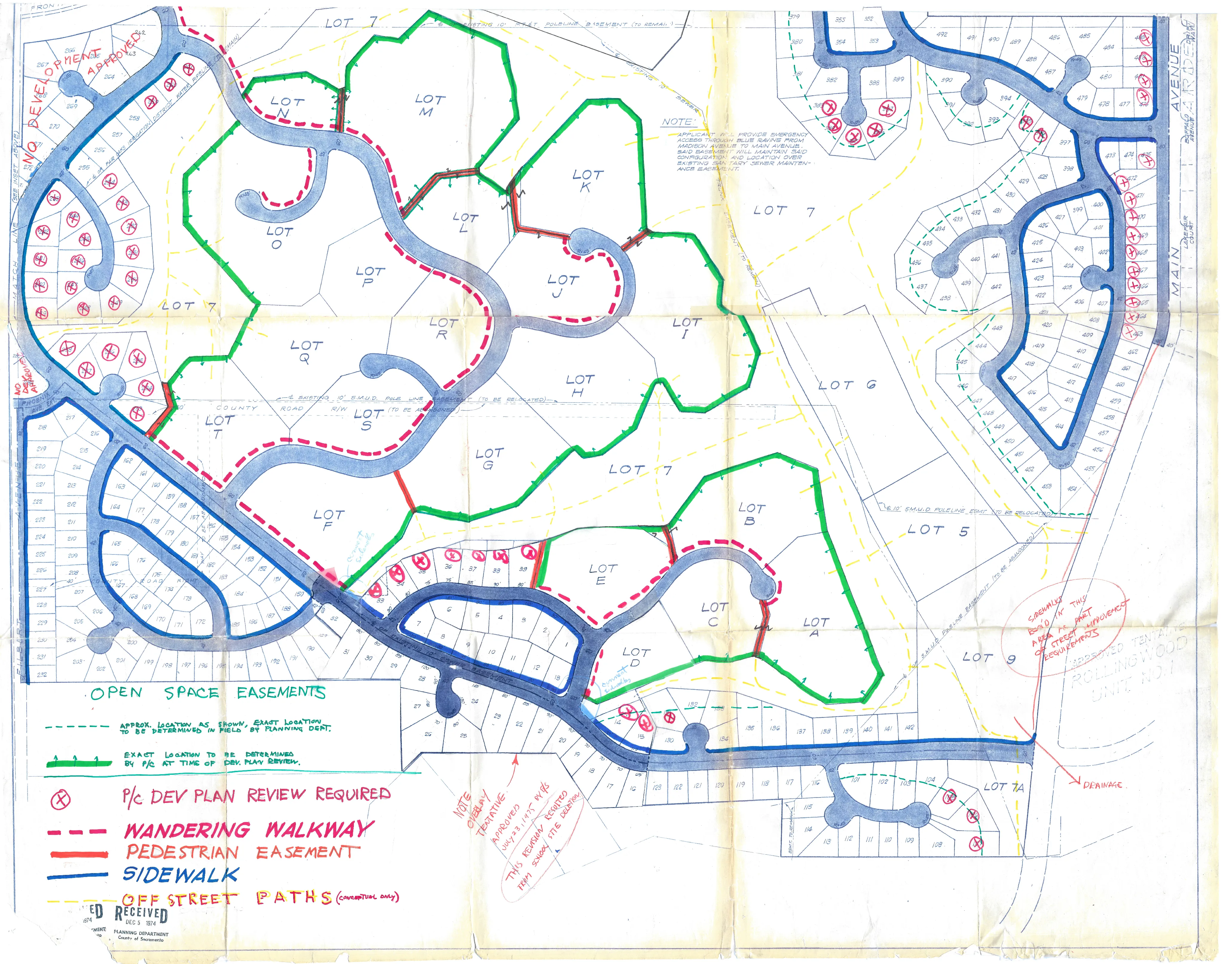
It is contemplated that the development controls, such as open space easements, or grants of development rights, be acquired for those areas indicated in Green as “Restricted Areas” on Exhibit “4”, to protect the environmentally sensitive ravine areas, in order to maintain such areas in their natural condition, and to add to or maintain the amenities of living in the neighborhood urbanized areas. Such development controls will be imposed at the time of approval of site development plans, when the exact location of the restricted areas can be determined, and shall be identified on the final subdivision map.
-
The Planning Commission may approve recreation facilities operated by a non-profit entity as a part of the site plan review, without a Use Permit application, and may approve the lot size for such facility without regard to the lot size limitation as set forth in Article 2, Chapter 8 of the Sacramento County Zoning Code.
SECTION 9. MULTIPLE FAMILY RESIDENTIAL AREA.
Section titled “SECTION 9. MULTIPLE FAMILY RESIDENTIAL AREA.”A precise development plan shall be submitted fo1· review and approval as provided in subsection “B” of this Section for that property described in Exhibit “A”, and shown and designated as “3. Multiple Family” on Exhibit “l”. Said property shall not be developed or improved until a site plan has been approved by the Planning Commission.
B. Site Development Plans.
Section titled “B. Site Development Plans.”The site plan shall be in substantial conformance with the standards set forth in Subsection “C” of this Section, and the standards set forth in Section 12. Such site plans shall show the location of all proposed improvements, trees to be retained and removed, parking, traffic circulation, and proposed landscaping. Such plans shall also include grading plans, floor plans, elevations, and perspectives sufficient to illustrate the full design character of the project. Said review and approval shall not render such property undevelopable to the uses and overall densities established herein.
C. Standards.
Section titled “C. Standards.”-
Lots 3, as shown on Exhibit “1”, shall not contain more than a total of 205 dwelling units. Such lots may also be developed with townhouse lots or condominium units, provided the owners of said lots record a subdivision map.
-
There shall be a minimum of twenty-five (25) feet of landscaping adjacent to any public streets and a minimum of fifteen (15) feet of landscaped area adjacent to any private drive or parking areas.
-
Parking areas providing at least two parking stalls for each dwelling unit shall be provided. The dimensions of the parking areas shall conform to the parking standards set forth in Chapter 15 of this Zoning Code, Ordinance No. 1111, as amended.
-
A sixty (60) foot wide public street shall be constructed and dedicated within the portion of the property described in Exhibit “A” as shown cross-hatched in red on Exhibit “4”. Said street shall be in the location and configuration approved by the County Department of Public Works.
SECTION 10. SHOPPING CENTER AREA.
Section titled “SECTION 10. SHOPPING CENTER AREA.”A precise development plan shall be submitted for review and approval as provided in subsection “B” of this section for that property described in Exhibit “A” and as shown as designated as “4. Shopping Center,” on Exhibit “1”.
B. Site Development Plans.
Section titled “B. Site Development Plans.”None of the property described in subsection “A” of this section shall be developed or improved until a site plan has been approved by the Planning Commission. The site plan shall be in substantial conformance with the standards set forth in Sections 23.10.043, 23.10.044, 23.10.045, 23.10.046, 23.10.047, and 23.10.048 of the Zoning Code, Ordinance No. 1111, as amended. Such site plans shall show the location of all proposed improvements, trees to be retained, and removed, parking, and traffic circulation. Such plans shall also include for approval grading plans, floor plans, elevations, and perspectives sufficient to illustrate the full design character of the project.
SECTION 11. RECREATIONAL AREA AND EQUESTRIAN AREAS.
Section titled “SECTION 11. RECREATIONAL AREA AND EQUESTRIAN AREAS.”A precise development plan shall be submitted for review and approval for that property described in Exhibit “A” and shown and designated as “proposed Equestrian Facilities and Proposed Recreational Facilities” on Exhibit “1”. Said property shall not be developed or improved until a site plan has been approved by the Planning Commission. The Planning Commission shall not approve said site plan unless it finds that the proposed recreational and equestrian facilities will not be detrimental to the health, safety, and general welfare of the persons residing in the neighborhood, and that such proposed facilities will not be detrimental or injurious to the property and improvements in the neighborhood. Such site plans shall show the location of all proposed improvements, trees to be retained and removed, parking, and traffic circulation. Such plans shall also include for approval grading plans, floor plans, elevations and perspectives sufficient to illustrate the full design character of the property.
SECTION 12. DEVELOPMENT STANDARDS.
Section titled “SECTION 12. DEVELOPMENT STANDARDS.”-
Private roads shall be sufficiently maintained so as to allow passage for fire trucks and other emergency vehicles and to the satisfaction of the fire district having jurisdiction over said property. All private roads are to be named and dwelling units are to be identified by signs showing unit numbers and such names and unit numbers shall be placed at locations visible to emergency vehicles.
-
All streets indicated on Exhibit “4” with shaded coloration shall be offered for dedication as public streets, and shall be constructed in conformance with the standards set forth in the County Improvement Standards adopted by Resolution No. 73-495 for Class “B” Streets as defined therein, except that Class “A” streets shall be provided on those sides of the streets where indicated by a solid blue line on Exhibit “4”.
-
Pedestrian walkways shall be constructed within dedicated pedestrian easements along the public streets where indicated by a dashed red line on Exhibit “4”. The precise location of said easements shall be approved by the Planning Commission. The design and specifications of said walkways shall be approved by the Public Works Department.
-
The Planning Commission shall during the site plan review process provided for in this ordinance consider and require where appropriate the following standards:
A. Grading.
Section titled “A. Grading.”The design, layout and configuration of the improvements shall minimize the extent and amount of grading. The following techniques shall be considered and utilized where feasible to accomplish the reduction in the extent and amount of grading:
-
The use of split-level building design, arid foundation systems to accomplish elevation transitions as close to existing grades as possible.
-
Driveway grades shall not be reduced below a grade of 10% where such reduction would require additional grading.
-
Grading for streets shall be reduced as much as possible consistent with the minimum requirements for utility service, drainage requirements and street design and improvement requirements.
-
The drainage system shall be designed to capture run-off from as small an area as possible so as to not divert such run-off from the ravine to which it naturally flowed.
-
Whenever energy dissipating devices are necessary to reduce water velocity at drainage outfalls, natural cobblestones or similar natural materials where appropriate shall be utilized to maintain the natural character of the area.
-
No grading shall be done on the property described in Exhibit “A” until a grading permit is obtained from the Public Works Department. The Public Works Department shall not approve any grading plans or issue any grading permit unless said plans are consistent with the site plans approved by the Planning Commission and with the policies as set forth in this section. No grading permit shall be issued for work to be conducted from November 1, through March 15, unless measures to prevent erosion are provided to the satisfaction of the Public Works Department.
B. Tree Removal.
Section titled “B. Tree Removal.”The design, layout and configuration of the improvements shall be accomplished so as to minimize the removal of trees. No trees shall be damaged or removed unless:
-
The trees are located within the right-of-way of an approved public street, or
-
The trees are specifically approved for removal by the Planning Commission as part of the site plan approval.
C. Noise Reduction.
Section titled “C. Noise Reduction.”The configuration and layout of the improvements shall be designed, and where necessary the developer shall provide noise attenuation devices, so that the interior community noise equivalent level (CNEL) with windows closed, attributable to exterior sounds shall not exceed an annual CNEL of 45dB in any habitable room. Methods to be considered shall include the orientation of the buildings, earth berms, solid fences, and building design features. A solid fence or wall shall be provided by the developer for noise attenuation on the rear of those lots adjacent to Main Avenue. The design of attenuation devices shall be subject to the advice of an accoustical engineer and the approval of the County Health Agency.
D. Subsequent Improvements.
Section titled “D. Subsequent Improvements.”The Board of Supervisors recognizes that after the development of the project has taken place, property owners and residents thereof may desire to make certain improvements, alterations and additions to their property. The Board of Supervisors having considered this possibility has determined that certain deviations such as, but not limited to, fireplaces, window and patio awnings, Bar-B-Ques and other normal ancillary landscaping features are insubstantial deviations from the requirements of this ordinance and do not constitute an amendment to the plan; and that such changes shall be permitted upon the issuance of any building permit issued pursuant to the provisions of Title 16, of the Sacramento County Code. The Board of Supervisors has further determined that certain deviations such as the erection of or addition to improvements such as ancillary buildings, swimming pools and fences and walls are not substantial deviations from the requirements of this ordinance provided such deviations are not inconsistent with the character of the plan nor do not decrease the amount of open space shown on the approved site plan by more than 5%. The Board hereby delegates to the Zoning Administrator the authority to approve any such changes. But in no event shall the Zoning Administrator permit an increase in the number of dwelling units or a decrease in the distances shown on the Exhibits to this Ordinance as “Minimum” or in any distances shown on any approved site plan as “Minimum”.
SECTION 13. PHASING.
Section titled “SECTION 13. PHASING.”The phasing of construction of dwelling units on the property described in Exhibit “A” shall be such that no more than ninety (90) building permits shall be issued for any group of residences having access only to Madison Avenue or Main Avenue is limited to a single connection. It is the intent of this section that no group of residences shall exceed ninety (90) units unless such group have access to both streets.
SECTION 14. FINDING.
Section titled “SECTION 14. FINDING.”During the public hearing on this ordinance, the Planning Commission and the Board of Supervisors determined that:
- The proposed development will carry out the intent of the general plan.
- The proposed development is of sufficient size and is designed so as to provide a desirable environment within its own boundaries.
- The proposed development is compatible with existing and proposed land uses in the surrounding area.
- The exceptions to the standard requirements of the Sacramento County Code, Ordinance No. 1111, as amended, are justified by the design of the development.
- The arrangements of dwellings and mixing of dwelling types is justified by a larger and more usable open space.
- There is adequate assurance that all public improvements will be installed at the scheduled times as required by the Public Works Department.
- There is adequate assurance that the development schedule will be met.
- The existing or proposed utility services are adequate for the uses and population densities proposed.
SECTION 15. VARIANCES.
Section titled “SECTION 15. VARIANCES.”The variance provision of Article 1, Chapter 18, of the Sacramento County Zoning Code, Ordinance No. 1111, as amended, shall not apply to this ordinance.
SECTION 16. VIOLATIONS.
Section titled “SECTION 16. VIOLATIONS.”Violation of the provisions of this ordinance or exhibits made part of this ordinance shall be deemed a violation of the Sacramento County Zoning Code, Ordinance No. 1111, as amended.
EXHIBIT 1: LAND USE PLAN.
Section titled “EXHIBIT 1: LAND USE PLAN.”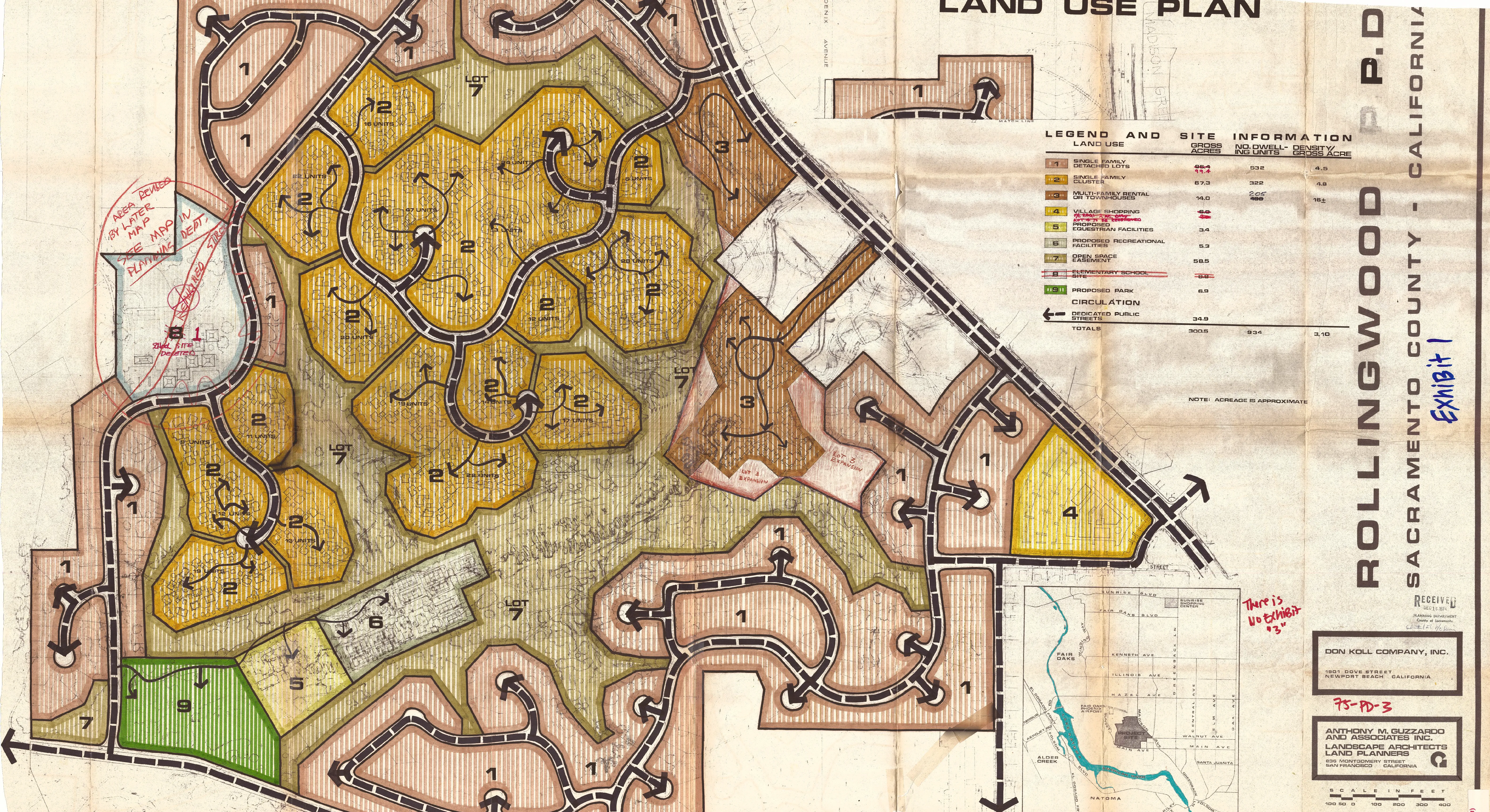
EXHIBIT 2: DEVELOPMENT PLAN.
Section titled “EXHIBIT 2: DEVELOPMENT PLAN.”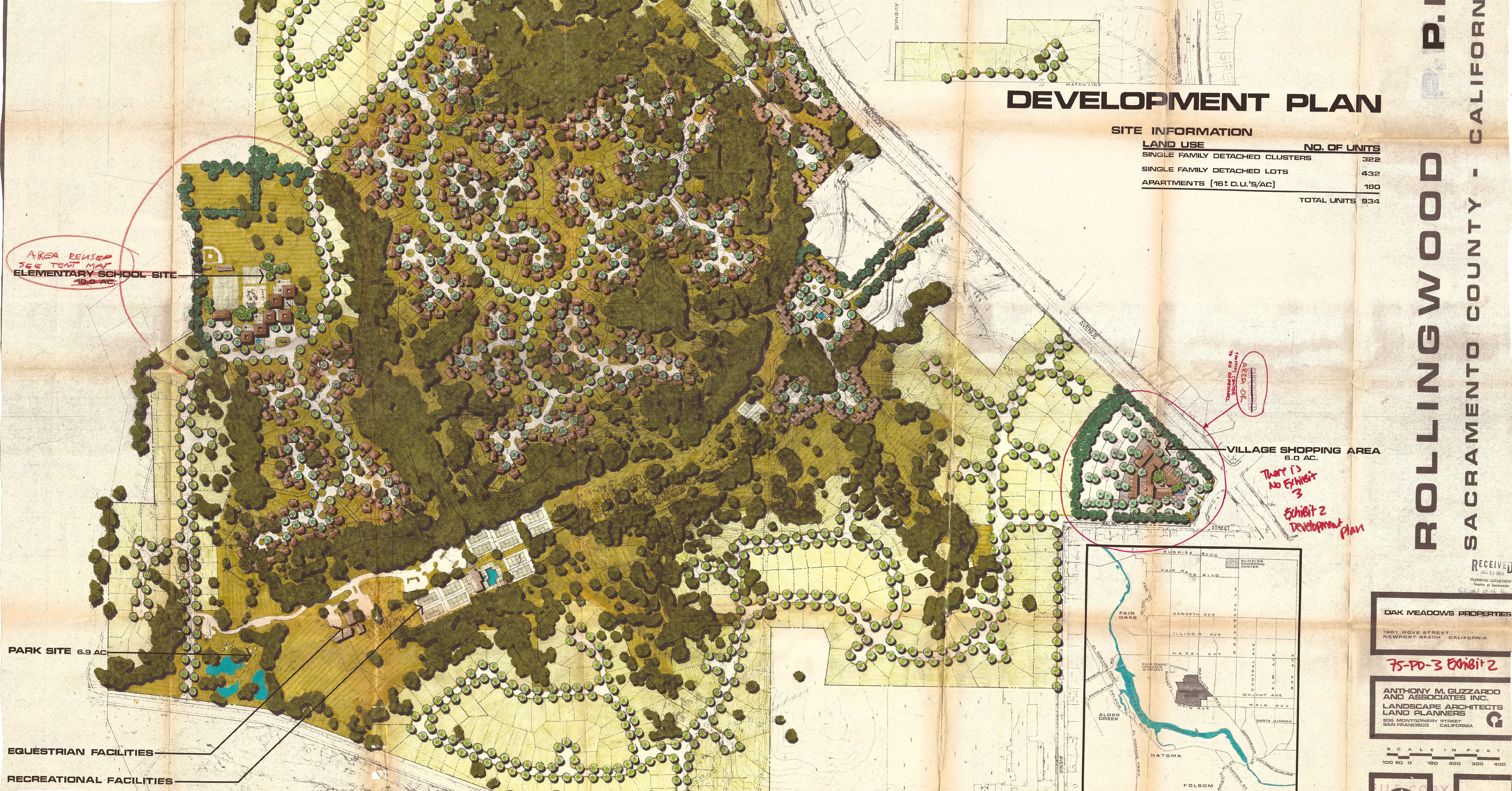
There is no Exhibit “3”
EXHIBIT 4: TENTATIVE SUBDIVISION MAP.
Section titled “EXHIBIT 4: TENTATIVE SUBDIVISION MAP.”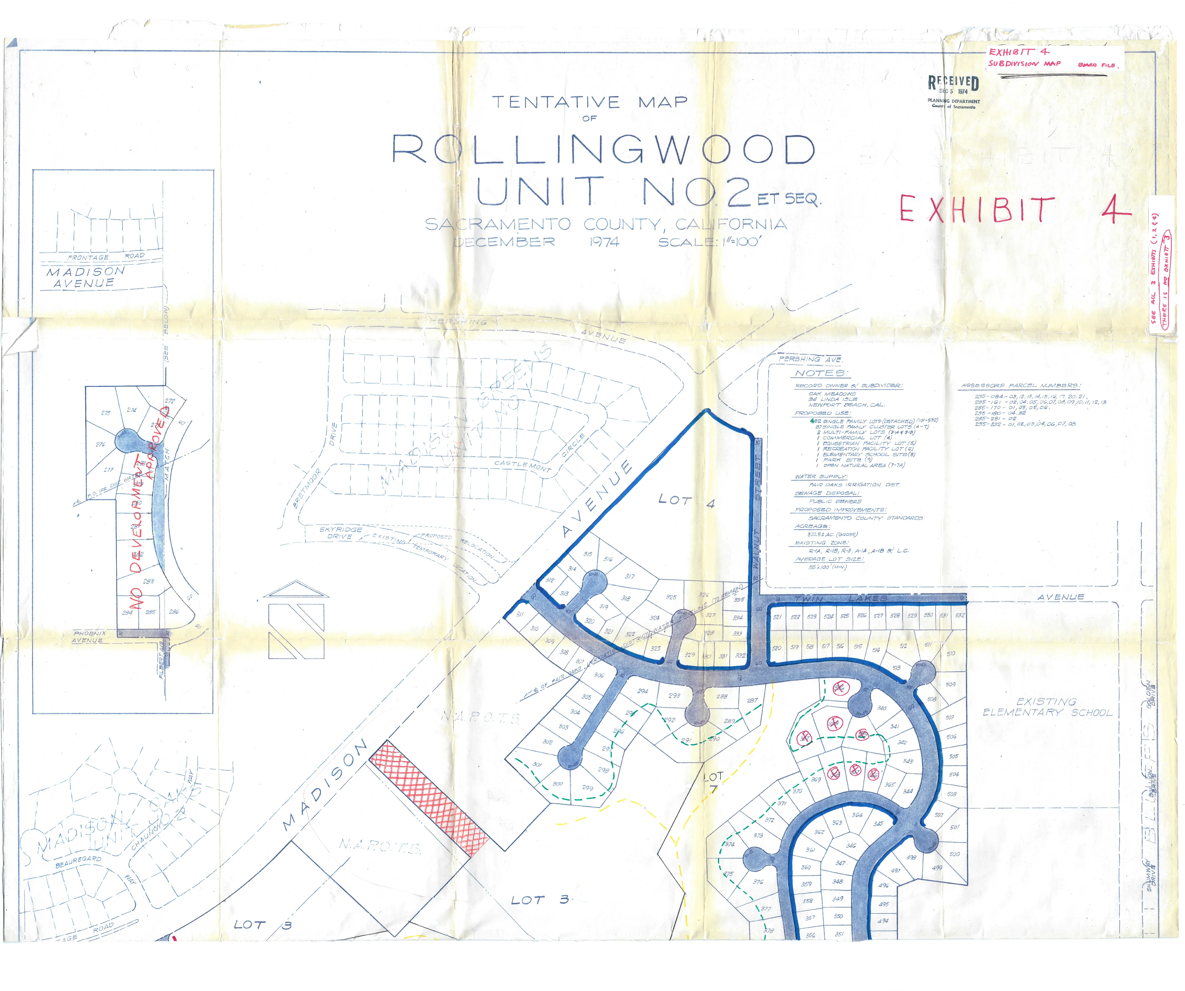
ASSOCIATED RESOLUTION: Fencing within Open Space Easements
Section titled “ASSOCIATED RESOLUTION: Fencing within Open Space Easements”The Board of Supervisors at a regular meeting held on December 13, 1979 approved Option No. 3 of the Planning Department report and directed that in order to insure continuity and conformity between the properties, the Zoning Administrator should attempt to adopt an overall fencing plan for individual areas.
The Board, in adopting Option No. 3, directed that “Chain link fences are expressly prohibited” be deleted from Exhibit “A”. That line is not reflected in the version shown below.
Excerpt from Staff Report:
Section titled “Excerpt from Staff Report:”OPTION 3
A promising option is to provide guidelines to the Zoning Administrator for use in utilization of existing provisions of the Ordinance. Section 12D of Ordinance 75-PD-3 reads in part:
The Board of Supervisors has further determined that certain deviations such as the erection of or addition to improvements such as ancillary buildings, swimming pools and fences and walls are not substantial deviations from the requirements of this ordinance provided such deviations are not inconsistent with the character of the plan nor do not decrease the amount of open space shown on the approved site plan by more than 5%. The Board hereby delegates to the Zoning Administrator the authority to approve any such changes. But in no event shall the Zoning Administrator permit an increase in the number of dwelling units or a decrease in the distances shown on the Exhibits to this Ordinance as “Minimum” or in any distances shown on any approved site plan as “Minimum”.
Unfortunately, there is no guidance regarding types of fences, tree retention, slope preservation or any other issue. The Planning Department has prepared a list of suggested guidelines (Exhibit “A”, attached.) The Department suggests that these guidelines be adopted by resolution. The Planning Director could then appoint the staff person who normally handles development plan review for Rollingwood projects Zoning Administrator for items involving Rollingwood. This approach would then be similar to development plan review by the staff and would not increase the workload of the Planning Commission or the Board. The Planning Department feels that this approach is the most useful of the options identified.
RECOMMENDATION:
Adopt Option 3 of this report.
This means adopting the attached list of guidelines (Exhibit “A”) of this staff report by Resolution. This will provide the Zoning Administrator a means of evaluating individual requests for fences and other structures and will ensure visual uniformity and minimal impact to the open space area. At the same time, a serious trespass problem can be alleviated with solutions tailored to each lot.
Adopted by Resolution of the Board of Supervisors – December 13, 1979
Section titled “Adopted by Resolution of the Board of Supervisors – December 13, 1979”EXHIBIT “A”
It is the purpose of the Rollingwood Ordinance to “maximize the preservation of the unique physical and scenic characteristics of the land…” It follows that any fencing permitted in the open space easement areas must be low key and as unobtrusive as possible. Prevention of trespass by off road vehicles is easily accomplished without resorting to chain-link security fences or high, solid walls. Accordingly, fencing must meet the following criteria:
Height: Solid fences shall not exceed 30 inches in height. No fence shall exceed 6 feet in height, all measurement are from grade at the base of the fence.
Fencing Materials:
Solid Fences: Solid fences shall be constructed of wood, logs, stone, or other natural materials. Cinderblock and similar materials are expressly prohibited.
See-through Fences: See-through fences shall be split-rail, wrought iron, post and cable or other unobtrusive materials.
Color: Fences shall be black, natural material color, or earth-tone as defined in Section 130-64 of the Zoning Code.
Location: Fences shall be located, at the discretion of the Zoning Administrator, in a manner to minimize physical and visual impacts on the open space easement consistent with the need to identify or protect property. In no case shall a fence be located beyond the lot line of the property in question.