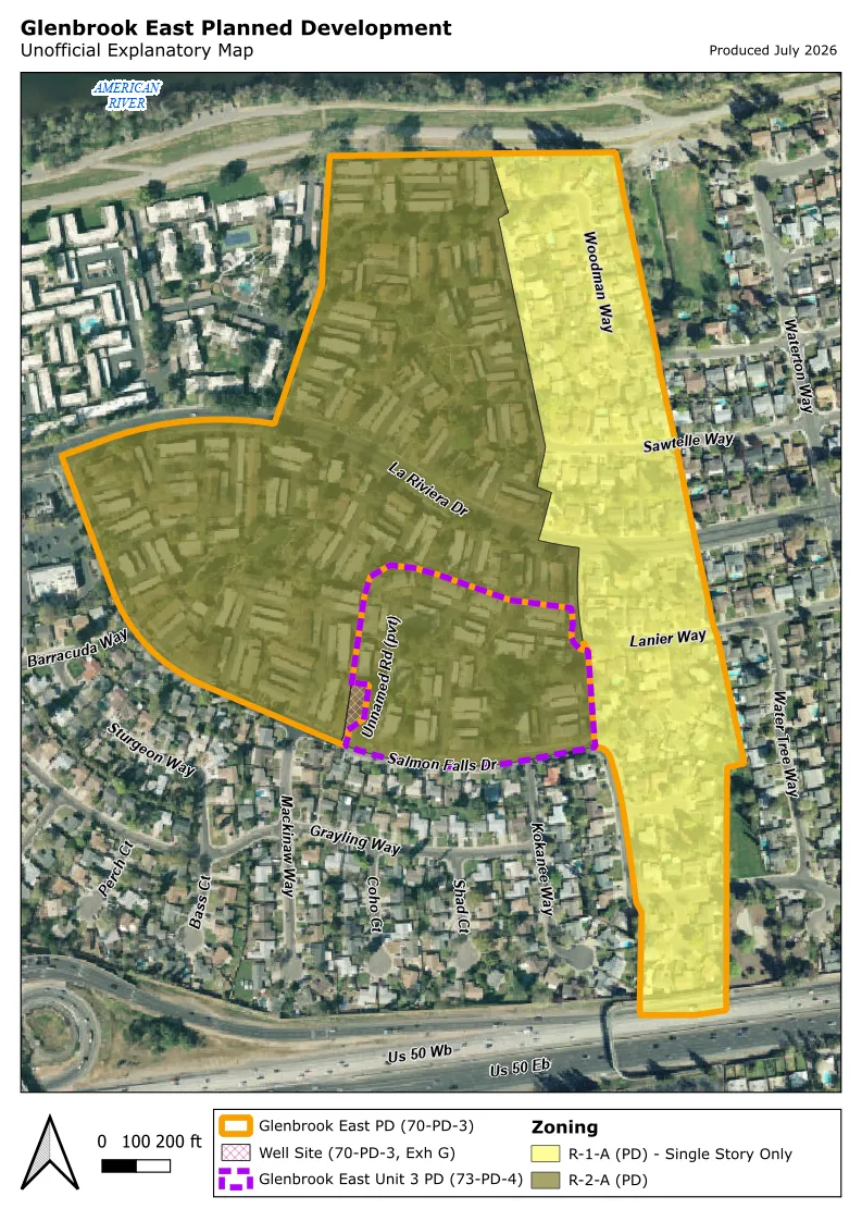
Glenbrook East PD
Sacramento County Zoning Code
Glenbrook East Planned Development Ordinance
Section titled “Sacramento County Zoning Code Glenbrook East Planned Development Ordinance”Adopted February 11, 1970
Amended February 3, 1971 & March 1, 1971 & June 30, 1971 & June 7, 1972 & August 8, 1973 & July 12, 1978
70-PD-3
Adopted by ZMA #2995
Amended by Ordinance 70-PD-3A & Planning Commission Resolution No. 635 & Ordinance 70-PD-3B & Ordinance 70-PD-3C & Ordinance 73-PD-4 & Ordinance SZC 78-97 (Cordova Consistency Rezone)NOTE: 73-PD-4 was rezoned out (“carved out”) of this PD and made into its own PD. The Cordova Consistency Rezone formally rezoned APNs 078-0390-013 and -014 (originally identified as “Trailer Storage”) out of the PD.
ARTICLE 1: General Provisions (Relating to Parcels 1 and 2, Exhibit “A” )
Section titled “ARTICLE 1: General Provisions (Relating to Parcels 1 and 2, Exhibit “A” )”SECTION 1.
Section titled “SECTION 1.”[AMENDED 06-07-1972]
NOTE: Ordinance 70-PD-3C amended this section to change the zoning classification of the real property described in Exhibit “A-1” (Glenbrook East Unit 9) to R-1-A Single Family Residential Zone.
Section 2 of Ordinance No. 534, as amended, is hereby amended to change the zoning classification of the real property described in Exhibit “A” as follows:
- Parcel No. 1 to R-2A (PD) Multiple Family Residential Zone (Planned Development)
- Parcel No. 2 to R-1A (PD) Single Family Residential Zone (Planned Development)
SECTION 2.
Section titled “SECTION 2.”[AMENDED 02-03-1971]
Exhibits “B” through “G”, inclusive, described generally in this Section and attached to this Ordinance are incorporated and made part of this Ordinance to regulate the property described in Exhibit “A”. The Exhibits are on file in the Office of the Clerk of the Board of Supervisors and are part of the Ordinance as if fully set forth herein.
Exhibits:
- “B” - Site Plan
- “C” - Typical Lotting Detail
- “D” - Phasing Plan
- “E” - Elevation Drawings (Eight separate sheets)
- “F” - Floor Plans (Three separate sheets)
- “G” - Location of well site
SECTION 3.
Section titled “SECTION 3.”For the purposes of this Ordinance certain phrases are defined as follows:
- "Dwelling Unit Group" shall mean two or more attached single family dwellings.
- "Common Area" shall mean property owned by a homeowners association.
SECTION 4.
Section titled “SECTION 4.”During the public hearings on this Ordinance the Planning Commission and the Board of Supervisors determined that:
- The proposed development will carry out the intent of the General Plan.
- The proposed development is of sufficient size and is designed so as to provide a desirable environment within its own boundaries.
- The proposed development is compatible with existing and proposed land uses in the surrounding area.
- Exceptions to the standard requirements of the Basic Zoning Ordinance are justified by the design of the development.
- The arrangement of dwellings and mixing of dwelling types is justified by larger and more usable open spaces.
- There is adequate assurance that all public improvements will be installed at the scheduled times as required by the Public Works Department.
- There is adequate assurance that the development schedule will be met.
- The existing or proposed utility services are adequate for the uses and population densities proposed.
SECTION 5.
Section titled “SECTION 5.”The maximum number of dwelling units in any dwelling unit group shall not exceed eight (8) dwelling units.
SECTION 6.
Section titled “SECTION 6.”The maximum number of dwelling units for each phase of construction shall not exceed the number of dwelling units indicated for said phase as shown on Exhibit “D”. It is the intent of the Board of Supervisors to permit flexibility in the arrangement and location of dwelling unit groups in each dwelling unit group. A developer shall fix both the location and the configuration of each dwelling unit group prior to the commencement of construction of each phase. The Planning Commission shall approve the location and configuration of the dwelling unit groups before the issuance of building permits for construction of the dwelling units in each phase. The Planning Commission reserves the right to increase the amount of storage area for trailers, boats, campers, and household equipment for subsequent phases of development provided there is evidence to show that the initial allocation for this use is inadequate.
SECTION 7.
Section titled “SECTION 7.”The common area shall be substantially as indicated on Exhibit “B”. The legal description of the common property shall be determined and submitted to the Planning Commission at such time as the precise location and dwelling unit group configuration of each phase is submitted to the Planning Commission. None of the common area shall be converted to any use other than for the private recreational uses of the owners, residents and guests.
SECTION 8.
Section titled “SECTION 8.”Parking areas shall be constructed and maintained as shown on Exhibit “B”. Parking areas shall not be converted to other uses.
SECTION 9.
Section titled “SECTION 9.”[AMENDED 03-01-1971]
The sequence of completion of the phases shown on Exhibit “D-1” shall be as follows:
- Phase 1. On or before 18 months after approval of the Final Development Plan for Phase 1.
- Phase 6, 7, and 7A. On or before 12 months after Phase 1 is completed.
- Phase 2. On or before 12 months after Phases 6, 7, and 7A are completed.
- Phase 3. On or before 12 months after 2 is completed.
- Phase 4. On or before 12 months after Phase 3 is completed.
- Phase 5. On or before 12 months after Phase 4 is completed.
- Phase 8. On or before 6 months after Phase 5 is completed.
To assure the development of the common area in each phase of the development the County of Sacramento shall be named as an additional party to the performance bond posted by the developer as required by the Department of Real Estate for completion of common areas. The Board of Supervisors delegates to the Planning Commission the authority to change the sequence of completion of the several phases.
SECTION 10.
Section titled “SECTION 10.”The minimum setback from the public street right-of-way for any dwelling unit group in Parcels No. 1 and 2 shall be twenty (20) feet or greater except where the face of the longest side of a dwelling unit group is at an angle of ten (10) degrees or greater to the public street right-of-way in which case the minimum setback shall be not less than fifteen (15) feet.
SECTION 11.
Section titled “SECTION 11.”The following uses for the property described in Exhibit “A” are prohibited:
- The parking and/or storage of commercial, industrial or agricultural motor vehicles or trailers rated more than one (1) ton capacity.
- Storage yards, storage buildings, garages, car ports, patio awnings, and similar accessory buildings except as otherwise shown on exhibits.
SECTION 12.
Section titled “SECTION 12.”Violation of the provisions of this Ordinance or Exhibits made part of this Ordinance shall be deemed a violation of the Basic Zoning Ordinance, Ordinance No. 534, as amended.
SECTION 13.
Section titled “SECTION 13.”Developer and/or owner of the property described in Exhibit “A” shall record a Subdivision Map and shall record an agreement to install County Standard Street Improvements with sidewalks on both sides of La Riviera Drive and on one side of the other streets except on the cul-de-sacs connecting to Lanier Way and Salman Falls Drive where no sidewalks are proposed.
SECTION 14.
Section titled “SECTION 14.”Owner shall provide the County a right-of-way across the Eastern portion of the common area in the Northeast corner of the development for utilities and public access to the American River.
ARTICLE 2: Provisions Relating To Parcel No. 1, Exhibit “A”
Section titled “ARTICLE 2: Provisions Relating To Parcel No. 1, Exhibit “A””SECTION 15.
Section titled “SECTION 15.”The property described in Parcel No. 1, Exhibit “A” be used only as follows:
- Single Family attached dwellings.
- Public Schools.
- The common area shall be limited to the private use for recreational and similiar purposes by the owners, residents and quests of the single family dwellings.
- Signs advertising a dwelling unit for sale, lease or rent is permitted providing the sign shall not exceed four (4) square feet and shall not be placed on property owned by a Home Owners Association.
SECTION 16.
Section titled “SECTION 16.”All dwelling units constructed in Parcel No. 1, Exhibit “A”, shall substantially conform in design, character and height with Exhibits “C”, “E” and “F”.
ARTICLE 3: Provisions Relating To Parcel No. 2, Exhibit “A”
Section titled “ARTICLE 3: Provisions Relating To Parcel No. 2, Exhibit “A””SECTION 17.
Section titled “SECTION 17.”[AMENDED 06-30-1971]
That portion of Parcel No. 2, Exhibit “A”, shown on Exhibit “B” as individual lots shall be regulated as to yards, lot area, lot width, height, and public street frontage as provided in the Single Family Residential Zone, Section 5 of Ordinance No. 534, as amended, however, buildings located on said individual lots shall not exceed one (1) story in height.
SECTION 18.
Section titled “SECTION 18.”[AMENDED 06-30-1971]
The property described in Parcel No. 2, Exhibit “A”, shall be permitted the uses set forth in the Single Family Residential Zone, Section 5 of Ordinance No. 534, as amended.
APPROVAL AND SUBSEQUENT ADDED SECTIONS
Section titled “APPROVAL AND SUBSEQUENT ADDED SECTIONS”SECTION 19.
Section titled “SECTION 19.”This Ordinance shall take effect and be in full force on and after thirty (30) days from the date of its passage hereof, and before the expiration of fifteen (15) days from the date of its passage it shall be published once with the names of the members of the Board of Supervisors voting for and against the same, said publication to be made in a newspaper of general circulation published in the County of Sacramento.
PASSED AND ADOPTED by the Board of Supervisors of the County of Sacramento, State of California, on the 11th day of February, 1970, by the following vote, to wit: AYES: Supervisors, GUALCO, O’BRIEN, PHELAN NOES : Supervisors, WOOD, KLOSS ABSENT : Supervisors, NONE
ATTEST: Earl D. Hack, Clerk of the Board of Supervisors
x E. Henry Kloss , Chairman of the Board of Supervisors of Sacramento County, California
(SEAL)
Sacramento Legal Press
Run 1 time, 2/23/70
Send One Affidavit & Two Bills with stone proofs attached to each.
SECTION 20.
Section titled “SECTION 20.”[ADDED 06-30-1971]
Minor deviations in the location of dwelling units, carports, outdoor parking and minor changes in use shall be permitted if approved by the Zoning Administrator. The Board of Supervisors hereby authorizes the Zoning Administrator to make such minor changes and in so authorizing has determined that such minor changes do not constitute an amendment to the Basic Zoning Ordinance, as amended.
SECTION 21.
Section titled “SECTION 21.”[ADDED 06-07-1972]
NOTE: This amendment rezoned Glenbrook East Unit 9 (a single-family subdivision south of the townhomes) out of the PD to R-1-A.
Notwithstanding any other provision of this ordinance, the property described in Exhibit “A-1” shall be regulated by the provisions of the Single-Family Residential Zone, Section 5 of Ordinance No. 534, and any amendments thereto.
EXHIBITS
Section titled “EXHIBITS”EXHIBIT “A”
Section titled “EXHIBIT “A””Parcel 1
Section titled “Parcel 1”DESCRIPTION
All that portion of Section 12, Township 8 North, Range 5 East, M. D. B. & M., described as follows:
Beginning at a point in the North boundary of parcel one (1) of those certain parcels of land conveyed to Security Title Insurance Company by a deed recorded August 14, 1964, document No. 92676, in Book 5036, at page 317, Sacramento County Official Records, from which the Northwest corner of Larchmont Riviera Unit No. 8, as shown on the official plat recorded January 10, 1968, in Book 81 of Maps, Map No. 24 in the Sacramento County Recorder’s Office Bears the following two (2) courses and distances, (1) North 89º 27’ 30” East 365.00 feet and (2) South 11º 43’ 21” East 496.08 feet; thence from said point of beginning South 18º’ 19’ 14” East 156.61 feet; thence along the arc of a left curve having a radius of 364.45 feet subtended by a chord bearing South 60° 46’ 01” East 47.75 feet; thence along the arc of a right curve with a radius of 179.00 feet subtended by a chord bearing South 63º 53’ 06” West 42.84 feet; thence South 19º 14’ 32” East 42.00 feet; thence along the arc of a right curve with a radius of 20.00 feet subtended by a chord bearing South 60° 28’ 56” East 30.08 feet; thence South 11º 43’ 21” East 581.98 feet; thence along the arc of a right curve with a radius of 30.00 feet subtended by a chord bearing South 01° 11’ 54” West 13.42 feet; thence along the arc of a left curve with a radius of 50.00 feet subtended by a chord bearing South 23° 01’ 14” East 60.38 feet; thence South 08º 54’ 43” West 99.45 feet; thence South 73º 47’ 34” East 40.42 feet; thence South 13º 46’ 26” West 105.00 feet; thence along the arc of a left curve with a radius of 960.00 feet subtended by a chord bearing South 78º 36’ 41” East 79.90 feet; thence South 09° 00’ 13” West 80.00 feet; thence along the arc of a right curve with a radius of 20.00 feet subtended by a chord bearing South 38º 54’ 02” East 26.81 feet; thence along the arc of a left curve with a radius of 899.83 feet subtended by a chord bearing South 02° 15’ 49” East 171.21 feet; thence along the arc of a right curve with a radius of 30.00 feet subtended by a chord bearing South 04º 39’ 02” West 12.86 feet; thence along the arc of a left curve with a radius of 50.00 feet subtended by a chord which bears South 31º 09’ 49” East 74.53 feet; thence South 05° 36’ 47” East 268.14 feet; thence along the arc of a right curve with a radius of 973.00 feet subtended by a chord bearing South 15° 00’ 10” East 234.45 feet; thence South 08° 05’ East 192.69 feet; thence along the arc of a right curve with a radius of 30.00 feet subtended by a chord bearing South 02° 26’ 08” West 10.95 feet; thence along the arc of a left curve with a radius of 60.00 feet subtended by a chord bearing South 32º 57’ 19” East 86.19 feet; thence South 00° 18’ 30” West 248.93 feet to a point on the North boundary of that certain parcel of land conveyed to the State of California by a deed recorded July 20, 1966, document No. 57737 in Book 66-07-20, page 24, Official Records; thence along the North and Northeasterly boundaries of said parcel South 86º 39’ 19” West 1051.15 feet; North 73º 04’ 41” West 964.78 feet; and North 31º 58’ 43” West 880.55 feet to the Southeast corner of that certain parcel of land conveyed to the County of Sacramento by a deed recorded September 5, 1968, document No. 64787 in Book 68-09-05, at page 33, Sacramento County Official Records; thence along the East boundary of said parcel along the arc of a right curve having a radius of 170 feet subtended by a chord which bears North, 1º 101 24” West 174.17 feet to a point in the East boundary of parcel 2 of those parcels of land conveyed to the County of Sacramento by a deed recorded June 23, 1966, document No. 50766 in Book 66-06-23, at page 441, Sacramento County Official Records; thence along said East boundary, North 34º 49’ 41” East 157.72 feet; thence leaving said boundary South 29º 13’ East 314 feet; thence North 76º 19’ East 708 feet; thence North 13º 06’ West 466 feet; thence North 74º 09’ East 21 feet; thence North 83º 29’ East 560 feet; thence North 13º 10’ East 516 feet; thence North 00° 19’ West 276 feet to a point in the South boundary of parcel 11 of the lands conveyed to Security Title Insurance Company by a deed recorded August 14, 1964, document No. 92666, in Book 5036, page 275, Sacramento County Official Records; thence along said South boundary North 89º 27’ 30” East 482.24 feet, more or less, to the point of beginning.
Parcel 2: DESCRIPTION OF THE GLENBROOK GARDEN HOMES EAST BUFFER STRIP
Section titled “Parcel 2: DESCRIPTION OF THE GLENBROOK GARDEN HOMES EAST BUFFER STRIP”February 3, 1970
All that portion of Section 12, Township 8 North, Range 5 East and Section 7, Township 8 North, Range 6 East, M. D. B. & M., described as follows:
PARCEL A: Beginning at the northwest corner of Larchmont Riviera Unit No. 8, the official plat of which is recorded in the office of the Recorder of Sacramento County in Bock 81 of Maps, Map No. 24; thence from said point of beginning along the westerly boundary of said Larchmont Riviera Unit No. 8 and along the westerly boundary of Larchmont Riviera Unit No. 7, the official plat of which is recorded in the office of said Recorder in Book 80 of Maps, Map No. 22, South 11º 43’ 21” East 1336.48 feet; thence South 78° 23’ 49” West 49.57 feet; thence South 00° 18’ 30” West 650.03 feet to a point located on the northerly right of way line of the proposed State of California Freeway; thence along said northerly right of way line, the following two (2) courses and distances: (1) South 81º 55’ 00” West 117.82 feet and (2) South 86° 39’ 19” West 133.72 feet; thence North 00° 18’ 30” East 248.93 feet; thence northwesterly, curving to the right on an arc of 60.00 feet radius, said arc being subtended by a chord bearing North 32º 57’ 19” West 86.19 feet; thence curving to the left on an arc of 30.00 feet radius, said arc being subtended by a chord bearing North 02° 26’ 08” East 10.95 feet; thence North 08° 05’ 00” West 192.69 feet; thence curving to the left on an arc of 973.00 feet radius, said arc being subtended by a chord bearing North 15° 00’ 10” West 234.45 feet; thence North 05° 36’ 47” West 268. 14 feet; thence northwesterly, curving to the right on an arc of 50.00 feet radius, said arc being subtended by a chord bearing North 31° 09’ 49” West 74.53 feet; thence curving to the left on an arc of 30.00 feet radius, said arc being subtended by a chord bearing North 04º 39’ 02” East 12.86 feet; thence curving to the right on an arc of 899.83 feet radius, said arc being subtended by a chord bearing North 02° 15’ 49” West 171.21 feet; thence curving to the left on an arc of 20.00 feet radius, said arc being subtended by a chord bearing North 38º 54’ 02” West 26.81 feet; thence North 09° 00’ 13” East 80.00 feet; thence northwesterly, curving to the right on an arc of 960.00 feet radius, said arc being subtended by a chord bearing North 78° 36’ 41” West 79.90 feet; thence North 13º 46’ 26” East 105.00 feet; thence North 73º 47’ 34” West 40.42 feet; thence North 08º 54’ 43” East 99.45 feet; thence northwesterly, curving to the right on an arc of 50.00 feet radius, said arc being subtended by a chord bearing North 23° 01’ 14” West 60.38 feet; thence curving to the left on an arc of 30.00 feet radius, said arc being subtended by a chord bearing North 01° 11’ 54” East 13.42 feet; thence North 11º 43’ 21” West 581.98 feet; thence curving to the left on an arc of 20.00 feet radius, said arc being subtended by a chord bearing North 60° 28’ 56” West 30.08 feet; thence North 19º 14’ 32” West 42.00 feet; thence northeasterly, curving to the left on an arc of 179.00 feet radius, said arc being subtended by a chord bearing North 63º 53’ 06” East 42.84 feet; thence curving to the right on an arc of 364.45 feet radius, said arc being subtended by a chord bearing North 60° 46’ 01” East 47.75 feet; thence North 18° 19’ 14” West 156.61 feet to a point located on the southerly line of the Sacramento-San Joaquin Drainage District Levee Right of Way; thence along said southerly line, North 89º 27’ 30” East 365.00 feet to a point located on the westerly boundary of that certain 3.000 acre tract of land designated “American River Flood Control District” on that certain Record of Survey entitled “Portion of Section 12, T. 8 N., R. 5 E., & Section 7, T. 8 N., R. 6 E., M. D. B. & M.”, recorded in the office of said Recorder in Book 17 of Surveys, at page 12; thence along said westerly boundary South 11º 43’ 21” East 496.08 feet to the point of beginning; containing 21.176 acres, more or less.
EXHIBIT “A-1”: PROPOSED BOUNDARY OF GLENBROOK EAST UNIT NO. 9
Section titled “EXHIBIT “A-1”: PROPOSED BOUNDARY OF GLENBROOK EAST UNIT NO. 9”[ADDED 06-07-1972]
February 15, 1972
All that portion of Section 12, Township 8 North, Range 5 East, M. D. B. & M., described as follows:
Beginning at the most southerly corner of Glenbrook East Garden Homes Unit No. 1, the official plat of which is re- corded in the office of the Recorder of Sacramento County in Book 85 of Maps, Map No. 8; thence from said point of be- ginning, curving to the left on an arc of 1027.00 feet radius, said arc being subtended by a chord bearing South 84º 58’ 35” East 561.23 feet; thence North 79º 10’ 00” East 197.52; thence curving to the right on an arc of 20.00 feet radius, said arc be- ing subtended by a chord bearing South 59º 36’ 44” East 26.36 feet; thence curving to the right on an arc of 973.00 feet radius, said arc being subtended by a chord bearing South 13º 14’ 14”. East 174.81 feet; thence South 08° 05’ 00” East 192.69 feet; thence curving to the right on an arc of 30.00 feet radius, said arc being subtended by a chord bearing South 02° 26’ 08” West 10.95 feet; thence curving to the left on an arc of 60.00 feet radius, said arc being subtended by a chord bearing South 32º 57’ 19” East 86.19 feet; thence South 00° 18’ 30” West 248.93 feet; thence South 86º 39’ 19” West 1015.49 feet; thence North 02° 09’ 30” West 100.00 feet; thence curving to the right on an arc of 45.00 feet radius, said arc being subtended by a chord bearing North 26° 53’ 26” West 81.74 feet; thence curving to the left on an arc of 55.00 feet radius, said arc being subtended by a chord bearing North 18° 06’ 35” East 38. 11 feet; thence . North 02° 09’ 30” West 451.79 feet; thence curving to the right on an arc of 471.00 feet radius, said arc being subtended by a chord bearing North 07° 45’ 28” East 162.22 feet to a point on the southerly boundary of said Glenbrook East Garden Homes Unit No. 1; thence easterly along the southerly boundary of said Glenbrook East Garden Homes Unit No. 1 the following four (4) courses and distances: (1) South 61º 11’ 51” East 42.87 feet, (2) curving to the right on an arc of 20.00 feet radius said arc being subtended by a chord bearing North 64º 52’ 03” East 29.87 feet, (3) South 66° 50’ 00” East 51.29 feet and (4) curving to the left on an arc of 1027.00 feet radius, said arc -being subtended by a chord bearing South 67º 58’ 35” East 40.97 feet to the point of beginning; containing 16.572 acres, more or less.
EXHIBIT “B”
Section titled “EXHIBIT “B””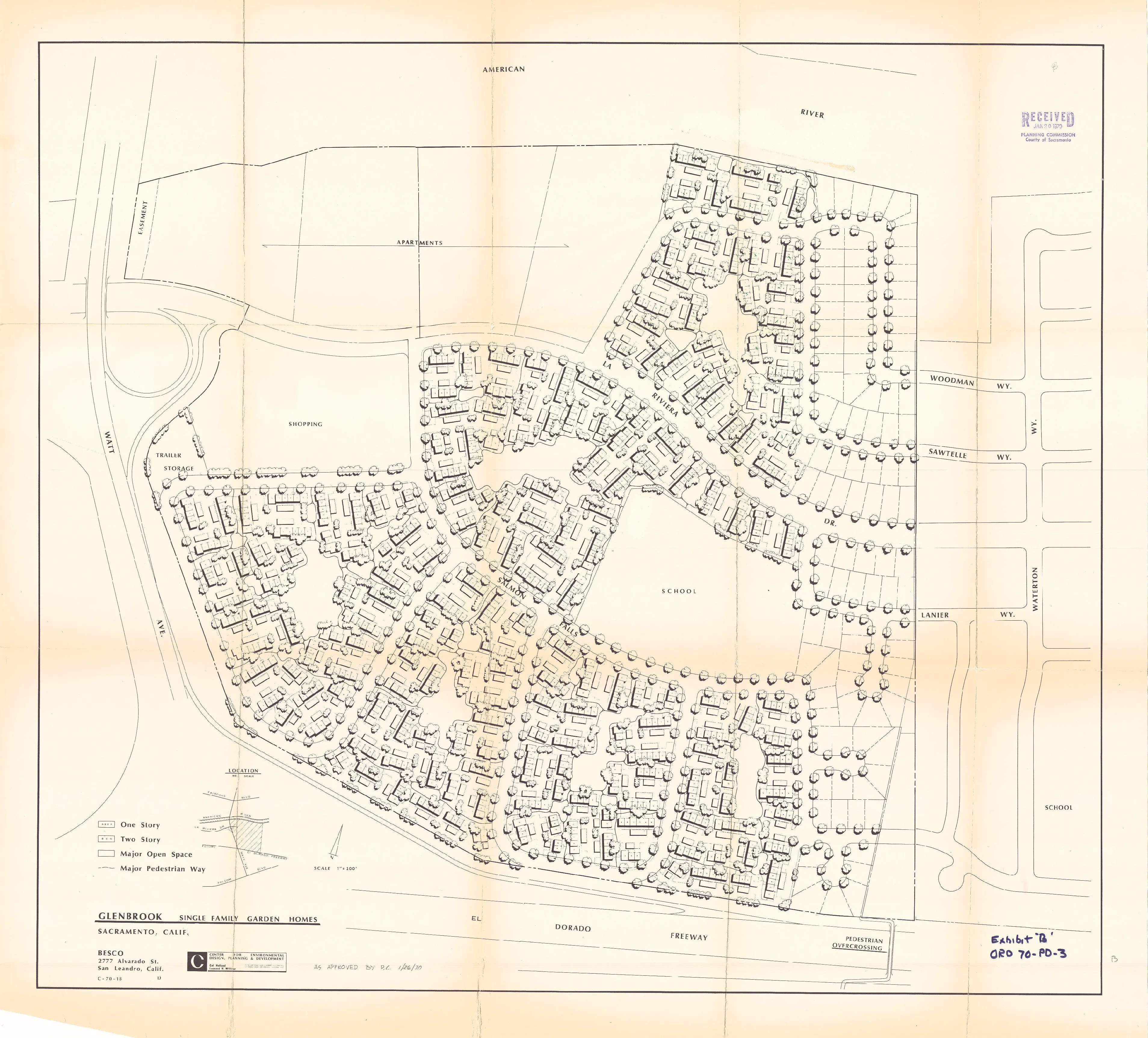
EXHIBIT “C”
Section titled “EXHIBIT “C””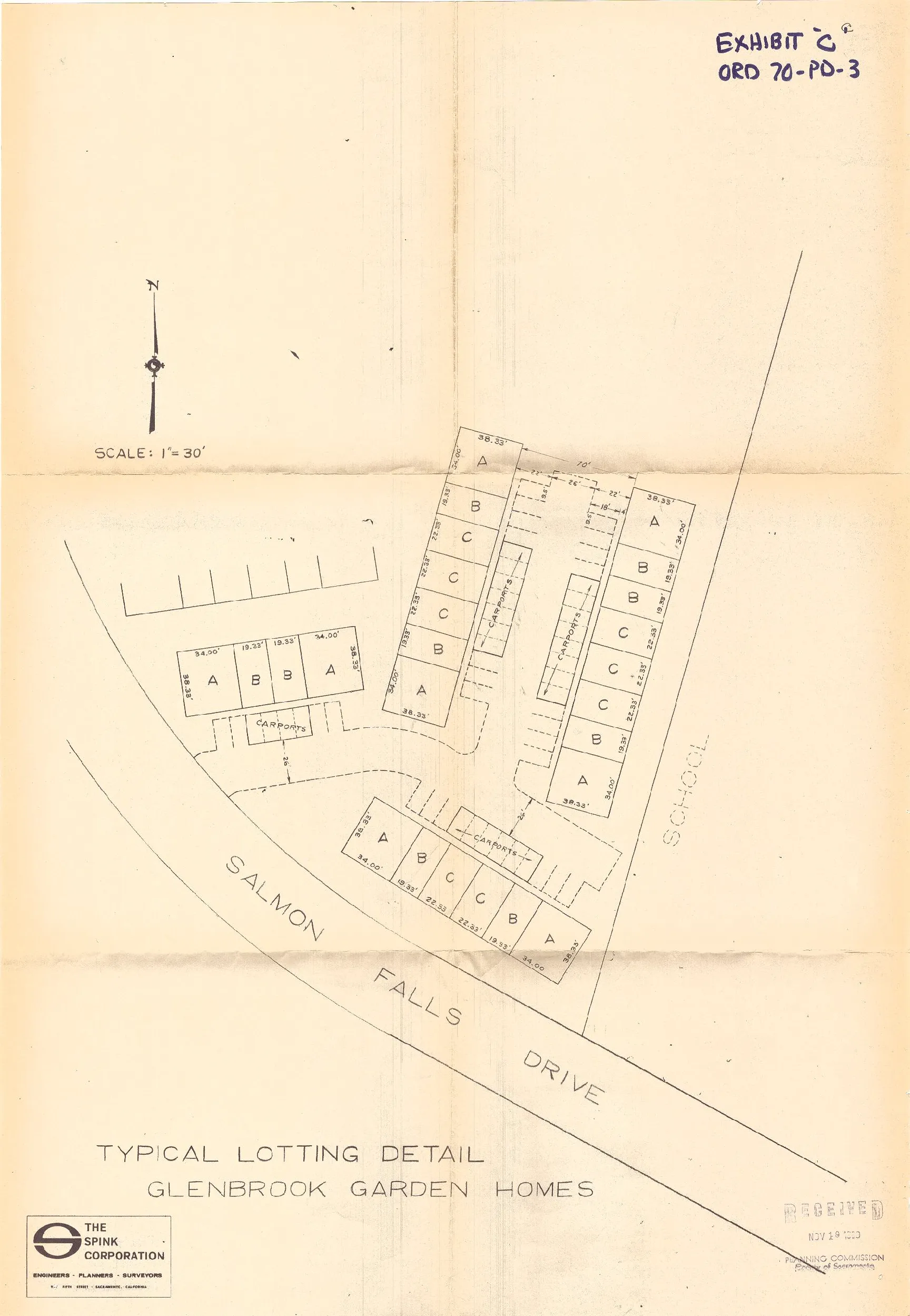
EXHIBIT “D”
Section titled “EXHIBIT “D””NOTE: The noted School, Phase 2, Phase 3, Phase 4, and Phase 5 were rezoned out of this PD over time. Phases 1, 6, 7, and 8 are within the PD as of 2026.
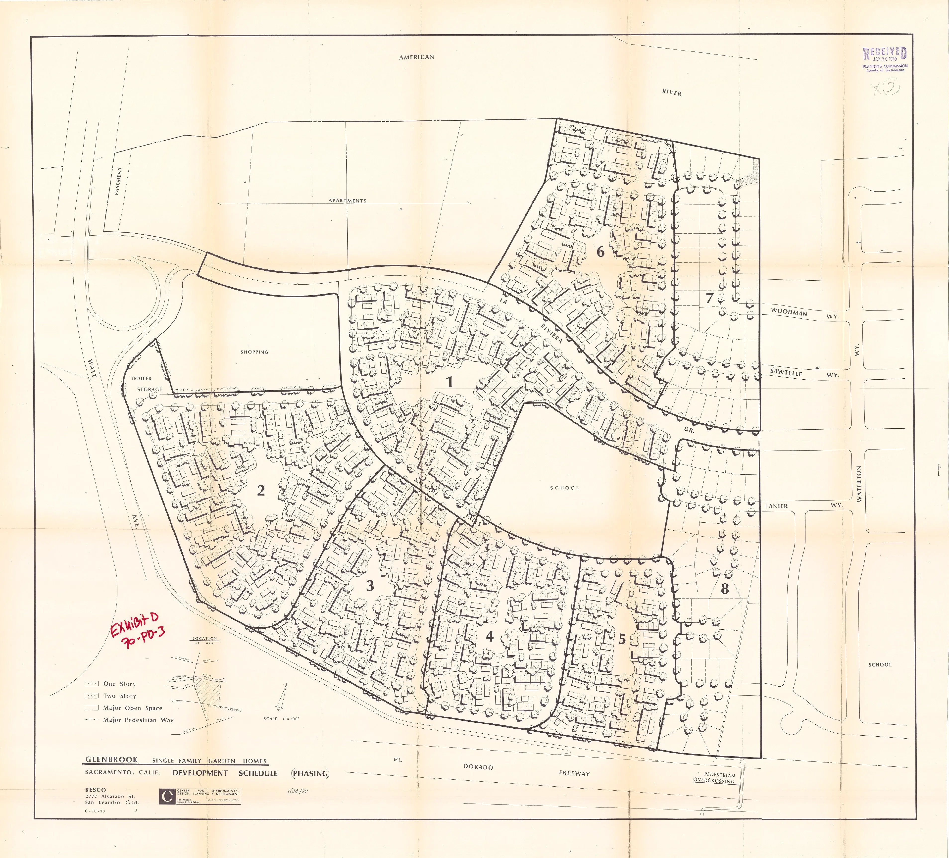
EXHIBIT “E”
Section titled “EXHIBIT “E””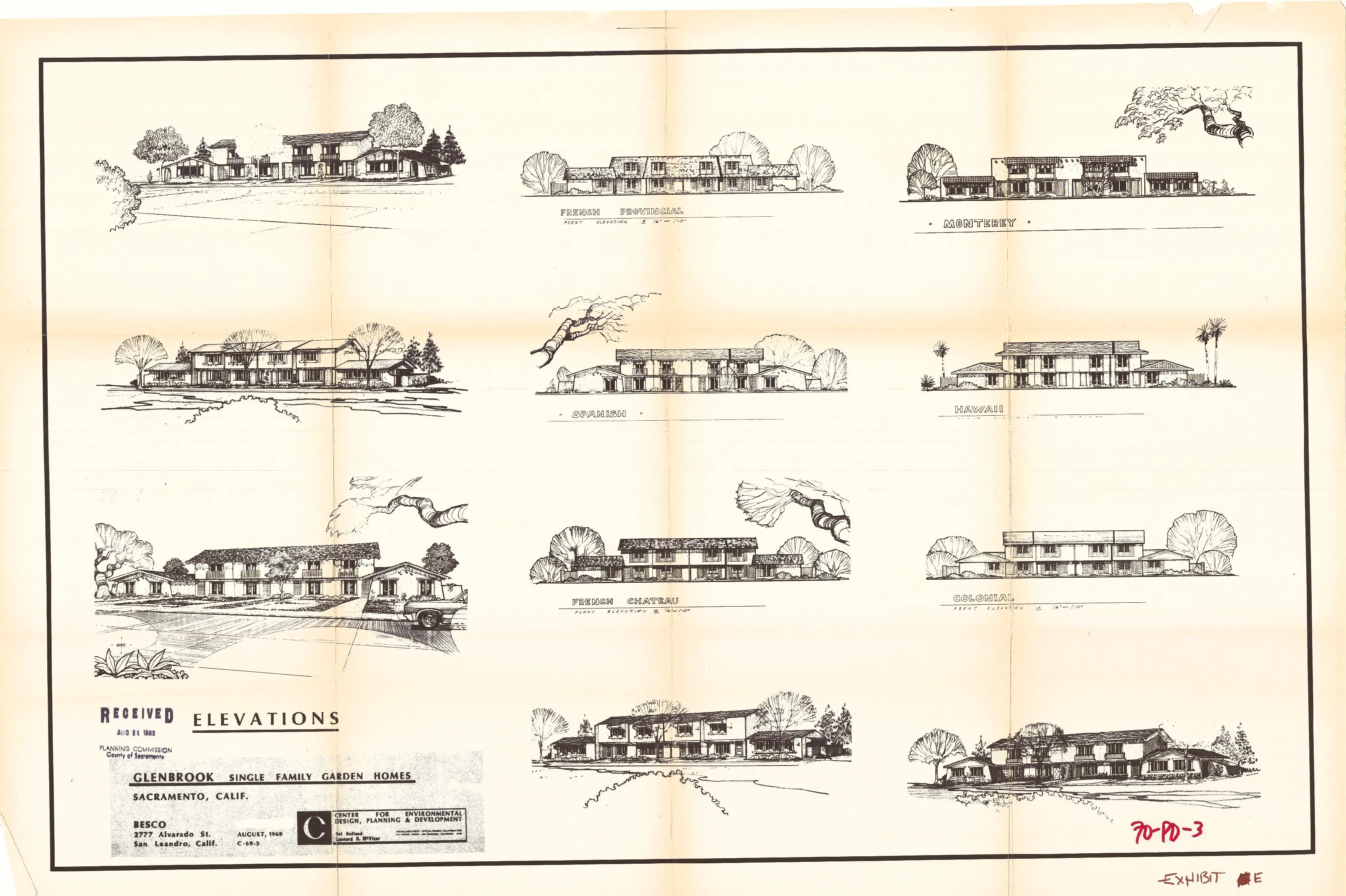
EXHIBIT “F”
Section titled “EXHIBIT “F””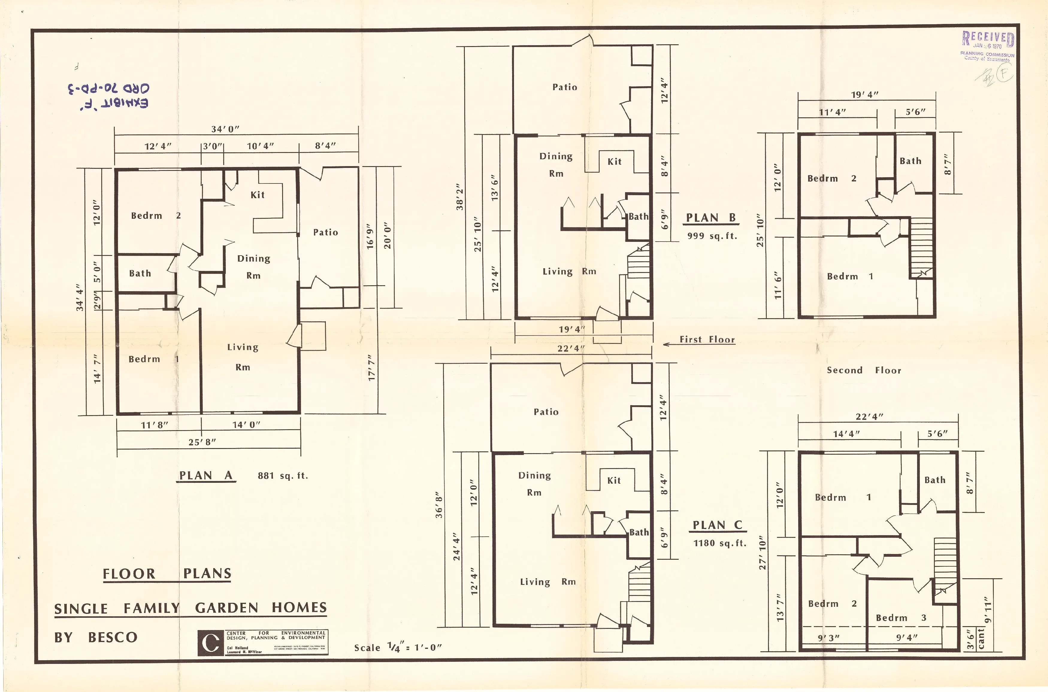
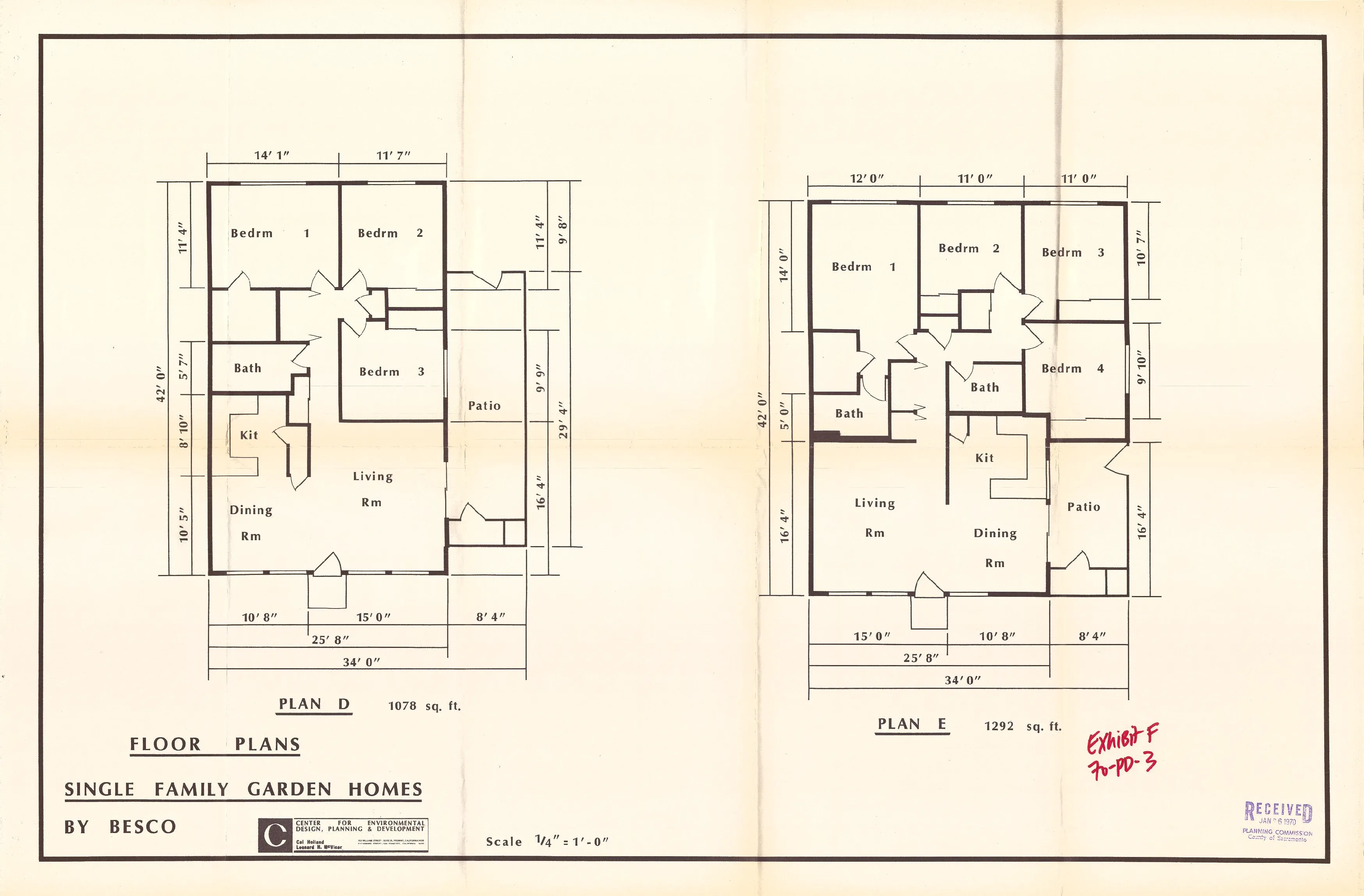
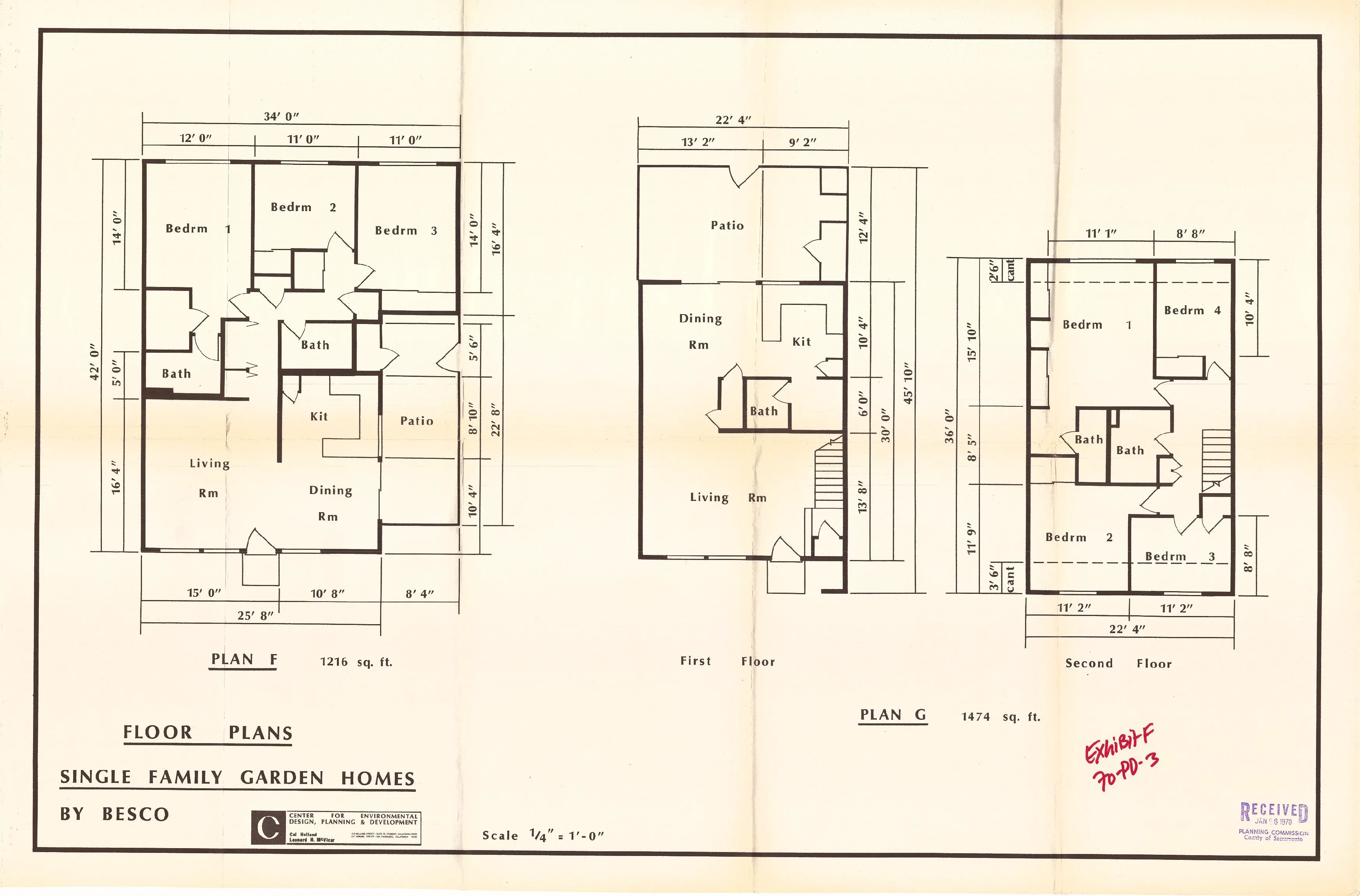
EXHIBIT “G”
Section titled “EXHIBIT “G””NOTE: This exhibit is missing, however, see the unofficial explanatory exhibit below for the location of the community well.