Pasatiempo II PD
Sacramento County Zoning Code
Pasatiempo II Planned Development Ordinance
Section titled “Sacramento County Zoning Code Pasatiempo II Planned Development Ordinance”Adopted March 5, 1975
75-PD-2
Adopted by ZMA #3352
SECTION 1.
Section titled “SECTION 1.”Section 23.01.162 of the Zoning Code of Sacramento County, Ordinance No. 1111, which incorporates Comprehensive Zoning Plan, Unit No. 332/176, amended to change the real property described in Exhibit “A” on said Comprehensive Zoning Plan to R-1-B (PD), Single Family and Duplex (Planned Development) Zone. Exhibit “A” is attached hereto and incorporated herein and made a part of this ordinance.
SECTION 2.
Section titled “SECTION 2.”Article 3 of the Zoning Code of Sacramento County, Ordinance No. 1111, is hereby amended by adding thereto Section 23.01.343 which shall read as follows:
Section 23.01.343 Planned Unit Development Ordinance, 72-PD-2.
SECTION 3.
Section titled “SECTION 3.”Exhibits “1” through “4”, inclusive, described generally in this section and attached to this ordinance are incorporated herein and made a part of this ordinance to regulate the property described in Exhibit “A”. The exhibits are on file in the office of the Clerk of the Board of Supervisors and are a part of this ordinance as if fully set forth herein.
Exhibits:
- Exhibit 1 - Site Plan
- Exhibit 2 - Typical Elevation
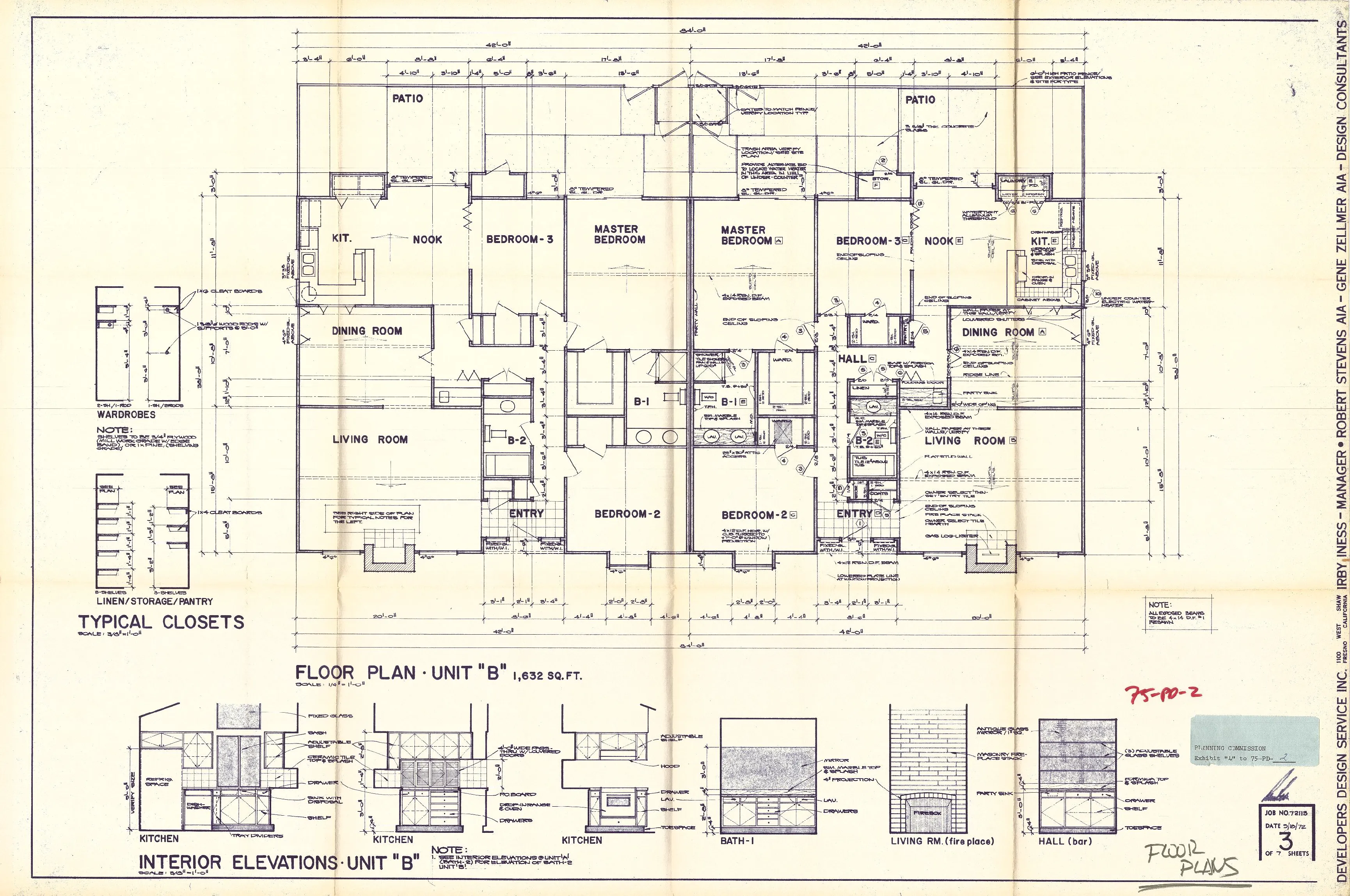
- Exhibits 3 and 4 - Typical Floor Plans
SECTION 4.
Section titled “SECTION 4.”All uses are authorized which are authorized in the Basic Zone with which the Planned Development Zone is combined, except that:
- No sign or other advertising device either temporary or permanent shall be erected, displayed or permitted on the property or upon any dwelling unit so that such sign is visible from the public streets without first obtaining the approval of the Planning Commission as to size, location, character, copy or duration, except that not more than one "for sale, rent, or lease" sign may be displayed upon such lot or dwelling unit by the owner thereof during the period such owner is selling, renting, or leasing said lot or dwelling; provided, however, that such sign shall not be larger than 18 inches by 24 inches.
- No animals, livestock, or poultry of any kind shall be raised, bred, or kept on any lot, except that dogs, cats, or other household pets may be kept provided they are not kept for any commercial purpose.
- No rubbish, trash, garbage, or other waste materials shall be kept or permitted on any lot, except in sanitary containers.
SECTION 5.
Section titled “SECTION 5.”The location, configuration, and arrangement of the buildings within the area described in Exhibit “A” shall be as shown on Exhibit “1”.
The dwelling units constructed within the property described in Exhibit “A” shall substantially conform to the typical elevations set forth in Exhibit “2”, and to the typical floor plans set forth in Exhibits “3” and “4”.
The Board of Supervisors recognizes that construction of the project, minor deviations from the location and configuration of the project, as shown on Exhibit “1”, may occur. The Board, having considered this possibility, has determined that insubstantial deviations from Exhibit “1” do not constitute an amendment to the plan and delegates to the Zoning Administrator the authority to approve any such changes. But in no event shall the Zoning Administrator permit an increase in the number of dwelling units or a decrease in the amount of open space as shown on Exhibit “1”.
SECTION 6.
Section titled “SECTION 6.”The location, configuration, and arrangement of the driveways, parking areas, and car ports shall be as shown on Exhibit “1”.
The owner of the property described in Exhibit “A” shall grant to the County of Sacramento by deed or dedication, any required corner roundings at Robin Lane and Fair Oaks Boulevard. Class “A” street improvements based upon a 42 foot total width as provided in the County Improvement Standards adopted by Resolution No. 66-1048 of the Board of Supervisors of the County of Sacramento, and amendments thereto shall be installed on Robin Lane.
The number of parking spaces shall not be less than the number shown in the tabulation set forth in Exhibit “1”.
The parking stalls shall conform to the parking standards set forth in Chapter 15 of the Zoning Code of the County of Sacramento, Ordinance No. 1111.
Parking stalls shall be identified to correspond with dwelling units except guest parking which shall be identified for that purpose. Parking areas shall not be converted to other uses.
The parking and storing of boats, trailers, recreational motor vehicles and camper bodies is prohibited except within the car ports.
SECTION 7.
Section titled “SECTION 7.”Construction of the project shall begin not later than twelve (12) months from the effective date of this ordinance, and the entire project shall be completed not later than twenty-four (24) months from the effective date of this ordinance.
Landscaping plans shall be submitted to the Planning Department and to the Parks and Recreation Department. No building permits shall be issued for buildings within any phase of the development until landscaping plans for that phase of the development are approved by said departments.
SECTION 8.
Section titled “SECTION 8.”Such plans shall, among other things, provide for a screen planting strip of at least six (6) feet in width, planted and maintained with trees along the northeastern and southeastern boundary lines of the project. A twenty-five (25) foot wide residential type landscaping strip on the side of the project adjacent to Fair Oaks Boulevard.
The landscaping of the property described in Exhibit “A” shall conform to the landscaping plans approved by the Planning Department and the Parks and Recreation Department.
No existing tree greater than four (4) inches in diameter shall be removed without the prior consent of the aforesaid departments.
Any source of lighting for the parking area of the project shall not be visible at the northeasterly or southeasterly property line above a plane located four (4) feet above the normal ground surface.
SECTION 9.
Section titled “SECTION 9.”During the public hearings on this ordinance the Planning Commission and the Board of Supervisors determined that:
- The proposed development will carry out the intent of the General Plan.
- The proposed development is of sufficient size and is designed so as to provide a desirable environment within its own boundaries.
- The proposed development is compatible with existing and proposed land uses in the surrounding area.
- Exceptions to the standard requirements of the Sacramento County Zoning Code, Ordinance No. 1111, are justified by the design of the development.
- The arrangements of dwellings and mixing of dwelling types is justified by larger and more usable open spaces.
- There is adequate assurance that all public improvements will be installed at the scheduled times as required by the Public Works Department.
- There is adequate assurance that the development schedule will be met.
- The existing or proposed utility services are adequate for the uses and population densities proposed.
SECTION 10.
Section titled “SECTION 10.”The variance provision of Article 1, Chapter 18, of the Sacramento County Zoning Code, Ordinance 1111, shall not apply to this ordinance.
SECTION 11.
Section titled “SECTION 11.”Violation of the provisions of this ordinance or exhibits made part of this ordinance shall be deemed a violation of Sacramento County Zoning Code, Ordinance No. 1111.
EXHIBIT “A”
Section titled “EXHIBIT “A””All that certain real property situate, lying and being in the County of Sacramento, State of California, particularly described as follows:
All that portion of Lot 2, as shown on the “Plat of Citrus Heights Addition No. 16”, recorded April 21, 1913 in book 14 of Maps, Map No. 6, records of said County, described as follows:
Beginning on the South line of a 60 foot road commonly known as Fair Oaks Boulevard or H. Street Road at its intersection with the Northeasterly line of said Lot 2; thence South 36°51’ East along said Northeasterly line a distance of 269.54 feet; thence South 57°47’ West 163.6 feet; thence North 36°12’ West 269.31 feet to the South line of said public road; thence North 57°47’ East 160.613 feet to the point of beginning.
EXHIBIT 1
Section titled “EXHIBIT 1”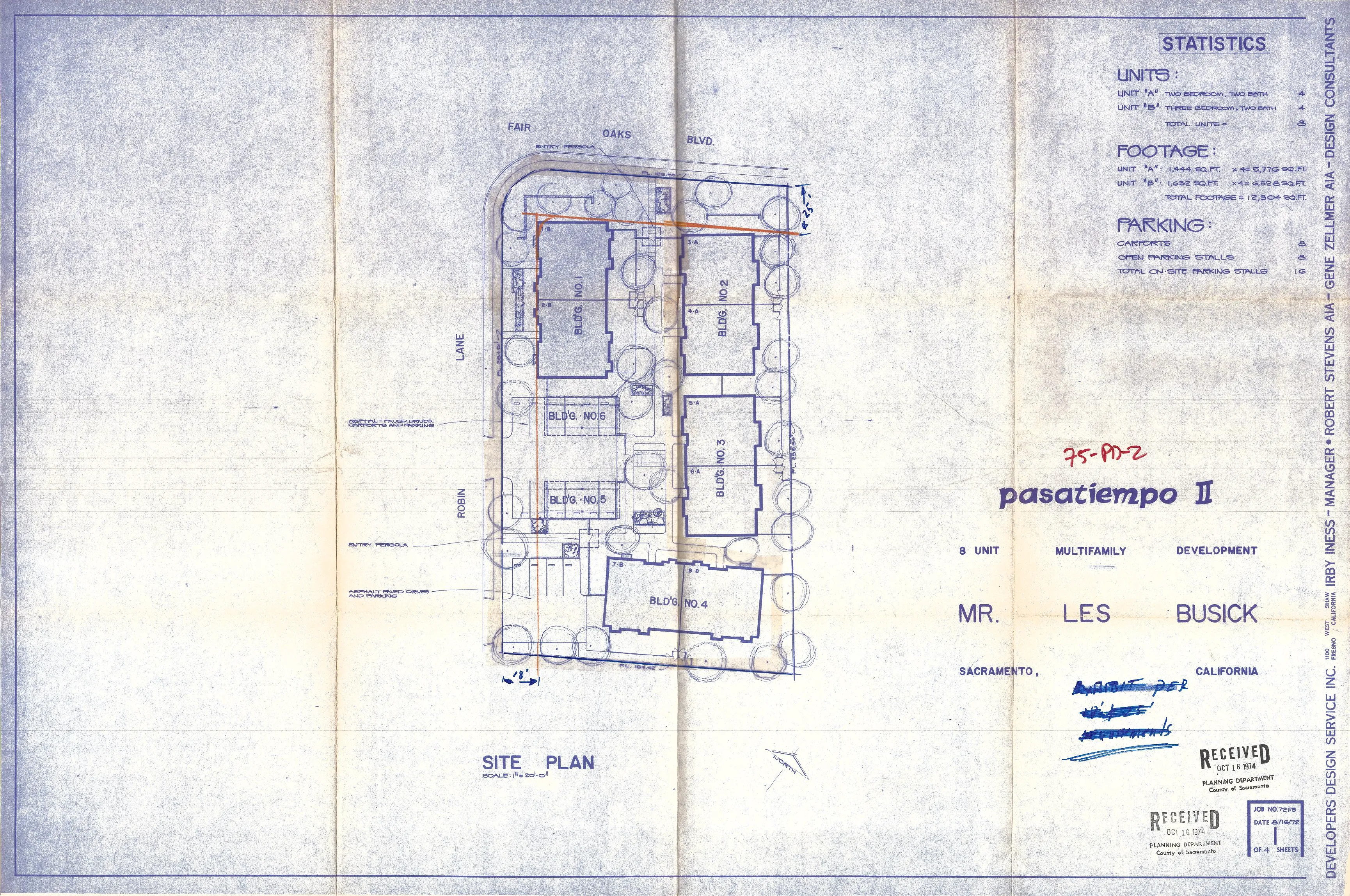
EXHIBIT 2
Section titled “EXHIBIT 2”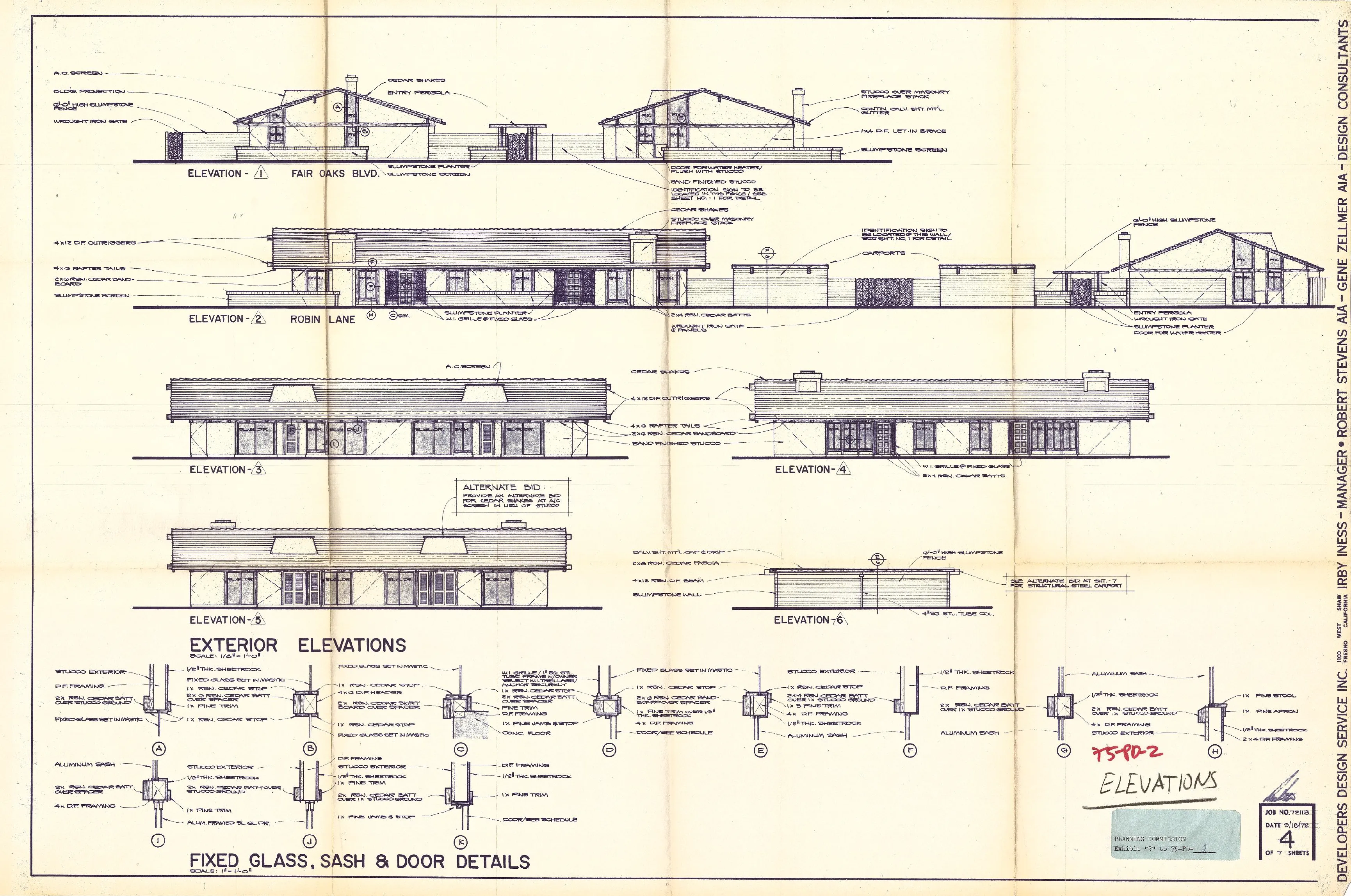
EXHIBIT 3
Section titled “EXHIBIT 3”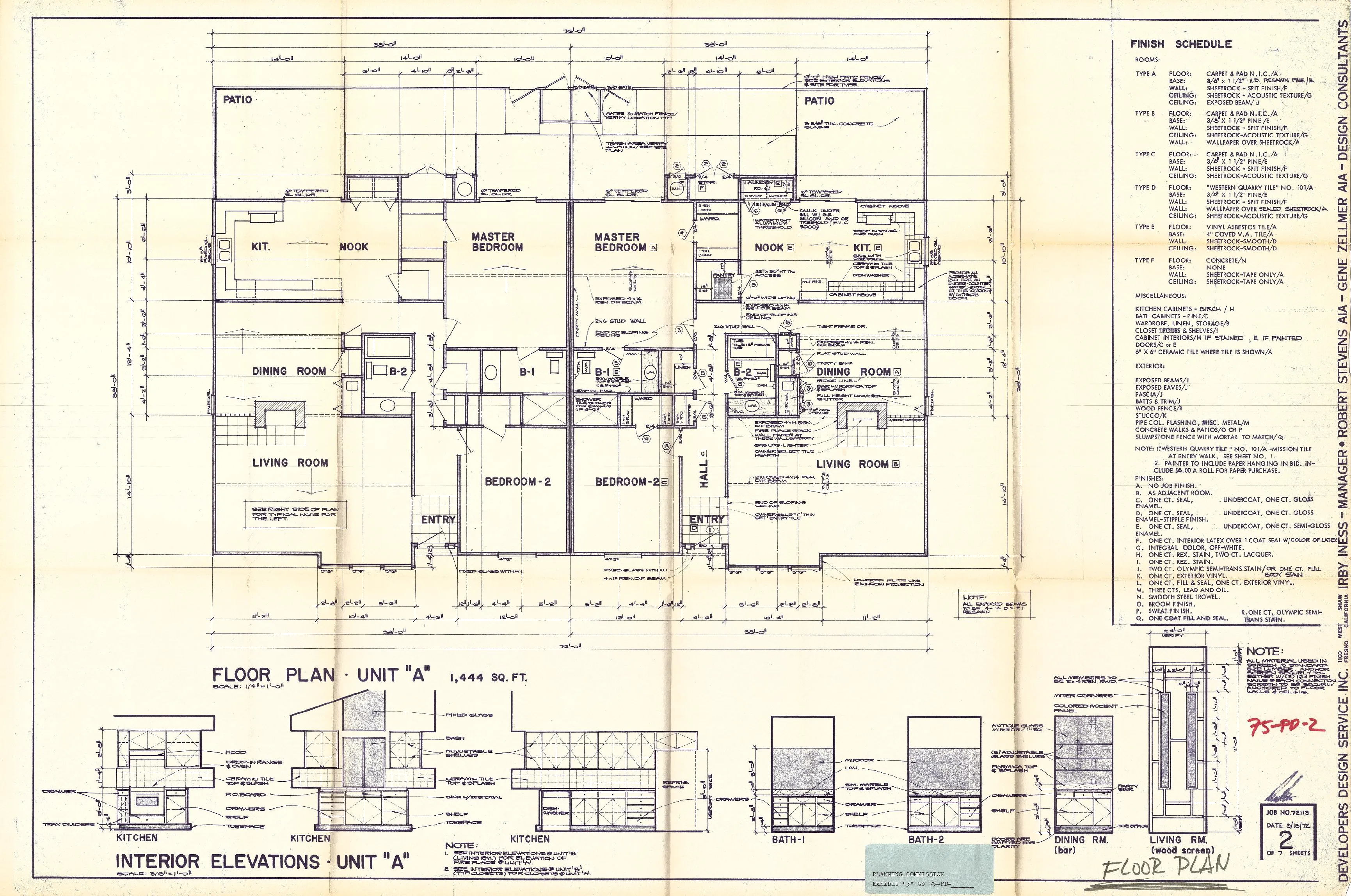
EXHIBIT 4
Section titled “EXHIBIT 4”