

Carmichael CP
Sacramento County Community Plans
Carmichael Community Plan
Section titled “Sacramento County Community Plans Carmichael Community Plan”Adopted October 15, 1975
Adopted by Board of Supervisors Resolution No. 75-1020Approved on January 15, 1975 by the Sacramento County Planning Commission
Approved by Planning Commission Resolution No. PO-75-12
ACKNOWLEDGEMENTS
Section titled “ACKNOWLEDGEMENTS”BOARD OF SUPERVISORS
- SANDRA R. SMOLEY, Chairperson
- E. Henry Kloss
- Patrick E. Melarkey
- Fred G. Wade
- Joseph E. Sheedy
COUNTY PLANNING COMMISSION
- FREDERICK G. STYLES, Chairman
- Rev. Keith Kenny
- Michael J. Gugliemetti
- Jane Dallen Hagedorn
- Crawford Williamson
COUNTY EXECUTIVE
- THOMAS G. CAMPBELL
COMMUNITY DEVELOPMENT AND ENVIRONMENTAL PROTECTION AGENCY
- WILLIAM B. POND, Administrator
PLANNING DEPARTMENT
- EARL D. FRASER, Director
ADVANCE PLANNING PROJECT STAFF
- ROGER TOINTON, Principal Planner
- Don Terrell
- Lin Toyama
- Howard McMackin
- Bob Huffman
- James Harnish
- Avis Skinner
- Ray Onga
- Barbara Takei
COMMUNITY ADVISORY COMMITTEE
- MARY ANN SMITH, Chairperson
CARMICHAEL CITIZENS ADVISORY COMMITTEE August 3, 1972
- Dodie Backus
- Mary Scott Ternus
- Mary Lou Block
- Catheren Vossler
- Ronald R. Brill
- Roderic C. Ward
- Barbara Bunner
- Don McIntyre
- William J. Fairbanks
- James Holden
- Bruce Ferguson
- Richard Pollock
- Gary M. Gallery
- Lucille Johnson
- Ruth Gay
- Larry Ainsworth
- Ken Girling
- Richard Taranto
- Cathrine Glashan
- Mr. F.M. Woodward
- Louis Kraushar
- Dr. & Mrs. Bugbee
- Marilyn Livingston
- Florence M. Jones
- Gail Mackenroth
- Virgil Phelps
- Joyce Mihanovich
- Mrs. James Burr
- Zoe Morgan
- Ivan Gennis
- Helen Skipworth
- Carl Holst
- Mary Ann Smith
- Ms. G.B.Smith
- Ada Squires
- Mr. & Mrs. William Olsen
Additional Persons Sitting on the Committee at Later Times
- Mr. & Mrs. William B. Applegate
- Dr. & Mrs. Louis Johnson
- Mrs. Charles Barker
- John R. Lewis
- Dr. & Mrs. Leland J. Bell
- James & Violet Moberly
- Elaine R. Byrnes
- Mr. & Mrs. Charles Newman
- Edna Clark
- Ms. Chris Pefley
- Mr. & Mrs. Harry A. Cobden
- Ray Reel
- Robert Findley
- Mary Scarlett
- Ben Franklin
- John Seiler
- Robert & Edna Gross
- Todd Sloan
- Shirley Hathaway
- Barry Smith
- Mr. & Mrs. Donald Herberholz
- Duane Verbas
- Mr. & Mrs. Allen Johnson
- Mr. & Mrs. H. R. Wagner
INTRODUCTION
Section titled “INTRODUCTION”This plan has been prepared as a guide for the physical development of Carmichael. It reflects the official policies of the Planning Commission and the Board of Supervisors in matters related to land use and zoning. Those policies, which are based upon the citizen’s goals and objectives, form the basis for the decision-making process which regulates the character, direction, and quality of urban growth in suburban Sacramento County.
The plan brings together under a single cover a discussion of a variety of matters related to the Carmichael area including land use, population, transportation, housing, parks and open space, and public facilities such as police and fire protection, water and sewage facilities, schools, etc. In doing so, it becomes a focal point for both action and reaction. Stated simply, the plan incorporates a consensus of community attitudes which, when translated into goals, objectives, policies and recommendations, provides a public statement as to what the future growth and development of the community will be.
The Carmichael Community study area is bounded on the west by Walnut Avenue and Arcade Creek, on the north by Madison Avenue, on the east by San Juan Avenue and on the south by the American River and Arden Way. The study area conforms as nearly as possible to other data and jurisdictional boundaries relating directly to Carmichael such as: the U.S. Bureau of Census Carmichael Area, the post office district and the Carmichael fire and park districts. As a study area this definition should not be misconstrued as the only valid description of the community area. It is, though, the most logical for the purposes of this study.
The subject matter of the plan is limited to a discussion of those portions of the natural, cultural and social environments of Carmichael which have a direct bearing upon the physical growth and development of the community. This includes a description of existing conditions and proposed changes, if any, in open space, natural resources, land use, population, housing, circulation, community facilities and parks.
LOCATION AND HISTORY
Section titled “LOCATION AND HISTORY”Carmichael is a 10 square-mile unincorporated community located about 10 miles northeast of downtown Sacramento along the north side of the American River. The first known settlers in the area were Maidu Indians dating back to 1000 B.C.: It is unclear as to when the Indians left this area, but as with most other California Indian communities, they probably were forced out when the white settlers arrived in the early 1800’s.
FIGURE 1: LOCATION MAP CARMICHAEL STUDY AREA, 1974
Section titled “FIGURE 1: LOCATION MAP CARMICHAEL STUDY AREA, 1974”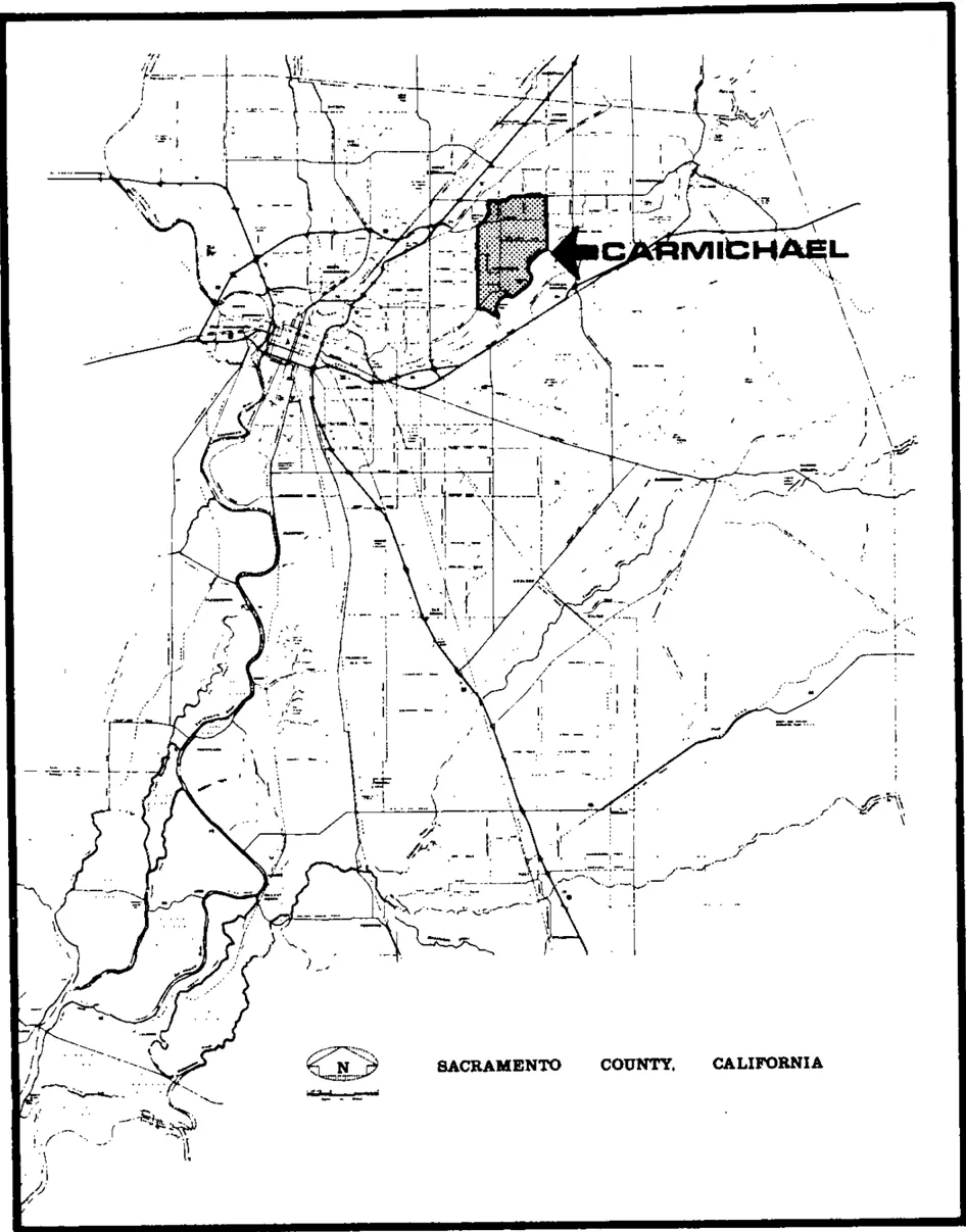
The first new settlers of Carmichael, the Deterdings, McDonnell’s, Deweys, and Ricketts farmed portions of the Colony as early as the 1880’s. The major activity prior to farming was the production of charcoal from the oak trees which once covered northeast Sacramento County.
Carved from a portion of two Mexican land grants of the 1840’s, Carmichael Colony was founded in 1909 by Dan Carmichael, real estate developer and former treasurer of both the City and County of Sacramento. The Colony was divided into 10 acre parcels which sold for $1500 each.
By 1940, there were about 1,000 people living in Carmichael. While many of the residents still farmed their 10 acre tracts, Carmichael’s rural character was already changing to that of a suburban bedroom community in the sprawling urban complex of Sacramento County. Following the end of World War II, Carmichael grew rapidly. While the Carmichael Irrigation District was established early in 1916 and the Fire Department in 1927, it was not until 1945 that a Chamber of Commerce was created. In the decade of the 1940’s, Fair Oaks Blvd. was transformed from a rural thoroughfare to a 2 mile-long business district as the population grew to almost 10,000.
Today Carmichael, having grown to a population of 41,000, has become a less identifiable community immersed in a still expanding unincorporated suburban area of 405,000 people. About the only remaining signs of the early Carmichael days are the palm trees along Palm Drive and the Deodar cedar in front of the post office, all planted around 1913.
COMMUNITY CONCERNS
Section titled “COMMUNITY CONCERNS”There are several major community concerns which the Carmichael Citizens Advisory Committee felt must be addressed by the Carmichael Community Plan. These concerns include: the preservation of those qualities which make Carmichael a good place in which to live; the preservation of as much of the semi-rural open space as possible; the provision of sufficient parks and open space; the protection of significant natural and cultural resources; and a solution to the transportation problems which have plagued Carmichael.
GOALS AND OBJECTIVES
Section titled “GOALS AND OBJECTIVES”The Carmichael Citizens Advisory Committee has identified, and the Planning Commission approved the following community goals and objectives for development of Carmichael. The goals are general statements of the ideals toward which the community desires to grow. The objectives are more specific points which are to be achieved through the plan. They are the ideal ends, or the goals.
GOAL I: TO MAINTAIN AND ENHANCE THE DISTINCTIVE CHARACTER AND IDENTITY OF THE CARMICHAEL COMMUNITY
Section titled “GOAL I: TO MAINTAIN AND ENHANCE THE DISTINCTIVE CHARACTER AND IDENTITY OF THE CARMICHAEL COMMUNITY”Objectives:
- Encourage a strong identification with the area along Fair Oaks Blvd. between Marconi Avenue and Carmichael Park as the community center.
- Work for the rehabilitation and enhancement of the major commercial areas of the community.
- Insure that the quality, location and type of commercial establishments are closely related to the needs and demands of the local population.
- Insure that past development trends do not necessarily establish a precedent for future development decisions.
- Protect the basically residential character of the area and emphasize the semi-rural (estate type) residential character in those areas of the community where it now exists.
- Provide for future expansion of multiple family residential developments only in those areas specifically set aside for such a use on the community plan.
- Establish logical, appropriate zoning districts through adoption and implementation of a community land use plan.
- Incorporate the design principles of the Gold Rush Parkway Plan into the Carmichael Community Plan.
GOAL II: TO ENSURE A HIGH LEVEL OF QUALITY IN ALL PHYSICAL DEVELOPMENT IN CARMICHAEL
Section titled “GOAL II: TO ENSURE A HIGH LEVEL OF QUALITY IN ALL PHYSICAL DEVELOPMENT IN CARMICHAEL”Objectives:
- Establish a system of architectural, landscaping, and sign controls which will allow the citizens of the community to determine how the community in which they live should develop.
- Discourage the proliferation of commercial strip development by encouraging developments to locate in well-designed, appropriately located neighborhood shopping centers.
- Urge that street-oriented utilities exhibit a high level of quality in their use and visual appearance, if any.
- Prohibit off-site signs within the community.
- Urge serious concern for the economic impacts of over-building of any business or service in the community.
GOAL III: TO PROVIDE A WIDE RANGE OF RECREATIONAL ACTIVITIES AND FACILITIES FOR THE COMMUNITY
Section titled “GOAL III: TO PROVIDE A WIDE RANGE OF RECREATIONAL ACTIVITIES AND FACILITIES FOR THE COMMUNITY”Objectives:
- Provide greater access for the pedestrian, equestrian and bicyclist from the residential areas to the American River Parkway.
- Develop a complete system of bikeways, pedestrian and equestrian trails throughout Carmichael.
- Assure a complete system of parks to achieve access within 1/2 mile of every residence.
- Actively encourage the coordination and implementation of existing recreational plans and programs of the Gold Rush Parkway, the American River Parkway, the Carmichael Recreation and Park District, and the Del Paso Park and Recreation District.
- Encourage and attract the establishment of culturally oriented activities and facilities.
- Provide for open space areas throughout the community.
GOAL IV: TO DEVELOP AN EFFICIENT, FULLY INTEGRATED AND ECOLOGICALLY BALANCED TRANSPORTATION AND CIRCULATION SYSTEM
Section titled “GOAL IV: TO DEVELOP AN EFFICIENT, FULLY INTEGRATED AND ECOLOGICALLY BALANCED TRANSPORTATION AND CIRCULATION SYSTEM”Objectives:
- Urge the elimination of fragmented transportation planning and the development of a coordinated statewide plan.
- Encourage the speedy development of an effective transit system serving Carmichael's specific needs.
- Develop a complete system of bikeways: pedestrian and equestrian trails throughout Carmichael.
- Secure improvements on collector and lesser streets in semi-rural residential neighborhoods of Carmichael. Provide safe walkways on all streets, particularly in the vicinity of schools and other facilities frequented by children.
- Encourage the regulation of sources of noise pollution.
GOAL V: TO MAINTAIN AND PRESERVE THE VALUABLE NATURAL AND HISTORICAL RESOURCES OF CARMICHAEL
Section titled “GOAL V: TO MAINTAIN AND PRESERVE THE VALUABLE NATURAL AND HISTORICAL RESOURCES OF CARMICHAEL”Objectives:
- Prohibit any excessive grading of land.
- Restrict the cutting of trees throughout the community.
- Encourage the maintenance of open spaces on private property.
- Preserve the natural habitat along the several stream courses draining toward the American River and along Arcade Creek for the use and enjoyment of the community.
- Identify and maintain sites of historical significance in Carmichael.
GOAL VI: TO WORK FOR FULL IMPLEMENTATION OF ALL RECOMMENDATIONS PRESENTED IN THE CARMICHAEL COMMUNITY PLAN
Section titled “GOAL VI: TO WORK FOR FULL IMPLEMENTATION OF ALL RECOMMENDATIONS PRESENTED IN THE CARMICHAEL COMMUNITY PLAN”Objectives:
- Support a capital improvement program for public improvements recommended in the plan.
- Periodically monitor and publicize progress of agencies and/or individuals responsible for all specific objectives of the Carmichael Community Plan.
- Periodically review, evaluate and recommend appropriate changes in the Carmichael Community Plan.
COMMUNITY IDENTITY
Section titled “COMMUNITY IDENTITY”GOAL: TO MAINTAIN AND ENHANCE THE DISTINCTIVE CHARACTER AND IDENTITY OF THE CARMICHAEL COMMUNITY.
GOAL: TO INSURE A HIGH LEVEL OF QUALITY IN ALL PHYSICAL DEVELOPMENT.
The past 30 years have been witness to a tremendous change in Carmichael and other suburban communities. The drastic increase in mobility, particularly with the automobile, and a flight to the suburbs created major problems, some of which still wait to be solved. The small, rural communities in Sacramento County of 30 or 40 years ago, such as Carmichael, are fast becoming only postal zones in the sprawling, unincorporated suburbia of Sacramento County.
The concept of community identity is one which deals with the affinity which people have toward the place where they live. Essential elements of this phenomenon are the qualities which make a particular area unique and a central place of activity.
The unique characteristics of Carmichael include the American River, trees, natural streams, horse pastures, and open, Semi-rural residential areas. The central place is basically the intersection of Marconi Avenue and Fair Oaks Blvd. where the Sacramento Valley Art Academy shopping center was located. This central place probably extends north to Carmichael Park.
As a result of urban sprawl, and the fact that much of the development taking place in Carmichael is by businesses and corporations headquartered outside the community, Carmichael’s community identity is eroding away. The open spaces are subdivided and important buildings are torn down. Consequently, the Carmichael many residents have known in the past is disappearing. A certain degree of such change is inevitable, even necessary, if Carmichael is to remain a vital, alive community. However, the new development which takes place should reflect the character and feeling of the best of Carmichael.
Considerable concern has been expressed among community residents that Carmichael’s unique qualities are being destroyed. This destruction is taking the form of new development within the community by groups or individuals who are either unable or unwilling to recognize Carmichael as a unique, separate community with a particular identity of its own. This tendency to develop commercial and residential areas in a similar fashion regardless of the environment has tended, over the last 20 years, to leave standardized, uniform, suburban areas throughout Sacramento County and California. For instance, the central place of Carmichael, once a readily identifiable location, has largely disappeared among the sterile buildings and clutter of signs strung out for blocks along Fair Oaks Boulevard.
A number of potential solutions to the problem of Carmichael’s fading identity exist. A strong design review process could insure that new commercial and multi-family structures reflect Carmichael’s individual character. The clutter of signs and billboards, particularly along Fair Oaks Blvd., could be eliminated. The future development of the central area of Carmichael’s commercial center could also have stronger guidance. A local community council could be created to bring some of the decision making process relative to such physical development closer to home.
DESIGN REVIEW
Section titled “DESIGN REVIEW”A design review process is a procedure whereby new commercial and residential development of the community can be guided in a positive direction. It would not necessarily specify a single architectural style or building material. It would not make everything look the same. But it would establish suitable building materials, colors, and styles and minimums for certain amenities such as landscaping. The design review process is one which essentially prohibits inadequate building proposals rather than requiring specific motifs. The major thrust of this process would be to require the developers of the land in Carmichael to recognize the character of the area as well as to adhere to minimum design standards that apply throughout the County. Design review would establish the machinery whereby major chain stores could be required to change their standardized building designs which presently remain the same from New York, to Texas, to Montana, to Carmichael. In effect, a sense of community identity should be imparted to the people who change the face of Carmichael, so that the residents who live and work here will not be forced to give up their sense of community.
The design review process would address the various elements of proposed development, including bulk, mass, height, color, dimensions and location of all buildings, relationship to surrounding area, landscaping, lighting, parking, signing. etc. Certain design criteria which should be considered would be whether or not the development: avoids repetitious and monotonous architectural character; maintains a harmonious relationship with the physical character of the site and neighborhood; and preserves as much as possible the trees and natural terrain. Commercial areas, particularly in central Carmichael, should provide space for public leisure in order to emphasize the area as a public gathering place.
The end product of this design review process would be a more pleasant, unique community structure which would maximize the benefits of Carmichael. A premium is placed upon open space and natural areas. The central gathering place could be visually revitalized which should increase the demand and patronage for individual developments as the overall quality of the area improves.
Probably the worst travesty of community identity in Carmichael is the signing along Fair Oaks Boulevard. Each business is competing with all the other businesses for customers with bigger, brighter, and more colorful signs to the point where the downtown commercial area of Carmichael is an insult to an individual’s sense of propriety. If Carmichael is to have a high esteem relative to its community identity, the central place must be a desirable, attractive environment.
Signs have traditionally been utilized for two purposes: to identify a particular business or location; and to attract people’s attention to a business, place, or product. The first purpose is a most necessary one if we are to get around in our urban areas. We need street signs, directional signs and signs identifying the place for which we are looking. The signs necessary to carry out this function generally are low key, simple, and to the point. They need not be obnoxious or offensive.
Signs designed to attract attention and, theoretically, business are problem-makers. These signs, in order to get people’s attention, have been made bright, flashing, oddly shaped or over-bearing. Generally, they are a combination of these characteristics. A single sign of this character may be a novelty. Two or three are interesting diversions. But when 200 businesses in a small area compete via bigger, brighter, more attention-getting signs, the area becomes such a visual hodge-podge that the original purpose of signs, to identify places, is lost. Over a period of time, the identity of a particular commercial enterprise should be established in a community by a combination of price, quality, service and convenience, and not just a garish sign which dominates the visual landscape.
The sign regulations need to be changed considerably if Carmichael’s central place is to be preserved and revitalized. Design review, discussed earlier, will regulate new signs to be constructed, but the major problem with signing is the signs that have already been built. To correct this, specific sign regulations dealing with not only height, area, and number, but also color, materials, and lighting must apply to all existing signs. Businesses should amortize non-conforming signs over a 3 to 5 year period and replace them with acceptable signs. All off-site signs should be prohibited within the community. The new sign regulation process should take the form of a strict sign ordinance adopted by Sacramento County.
COMMUNITY CENTER
Section titled “COMMUNITY CENTER”An identifiable central place in Carmichael is important to maintaining community identity. This concept has at least two different aspects applicable to Carmichael. First, the central business area along Fair Oaks Blvd. from Marconi Avenue to Carmichael Park, can be guided so as to emphasize and enhance the area as the identifiable community center. Secondly, a building or group of buildings might be built to house major civic activities and hence be identified as the community center.
Organizing the redevelopment activity of downtown Carmichael is very much needed. Currently, when an old building is demolished and a new structure built, it is an isolated project, unrelated to the neighboring area. It has its own driveway, parking area, landscaping, etc.; as does the neighboring development. Consequently, the only circulation pattern connecting stores is Fair Oaks Blvd. Lack of traffic flow from store to store is a major contributor to traffic congestion along Fair Oaks Blvd. It is also a significant detractor from business. An official plan for the central commercial area is needed. Over a period of time, businesses could share parking and driveways and provide coordinated landscaping, signing and building setbacks. The individual would retain control over his specific building plans and would have the advantage of not competing with his neighbor for parking, etc. This cooperation would not only create a unified community center where people could shop and enjoy their surroundings, but it would enhance the entire commercial atmosphere in Carmichael.
The second aspect of the central place concept–a community center composed of one or more public buildings– should simply augment the enhancement of the central business area. An activity center or public meeting hall would serve as the center of civic activity. Major community events might take place there. Civic groups might use the facility as a regular meeting place. It could contain a variety of public offices. It would, in effect, be a town hall. The Carmichael Park Clubhouse acts as this type of facility presently, but it is not adequate to handle major community events. In addition, it is already used almost continuously and can handle little more demand.
A new community center, if built, should be located close to the identifiable center of Carmichael. One potential location would be adjacent to the park on the east side of Fair Oaks Boulevard. Regardless of the location, the major problem relative to such a proposal is who will build the facility and with what money? In a time of so many pressing economic needs, it will be difficult to secure monetary backing for such a project. Interested citizens and public agencies are urged to establish a cooperative effort to discuss the merits of such a proposal, investigate alternative methods of financing, and formulate recommendations for action.
COMMUNITY ADVISORY COUNCIL
Section titled “COMMUNITY ADVISORY COUNCIL”A major need in Carmichael is to bring the decision making process, which regulates the physical change of the community, closer to the people. With an increasing interest in planning among community residents, the process will change to effectively deal with the needs of the people who are being served by it. In this light, a revision of the planning process in Sacramento County is recommended. This will take the form of a Community Advisory Council which would review and comment on all matters related to planning in Carmichael. This Council, made of community residents, would provide a sounding board for the Planning Commission and Board of Supervisors.
RECOMMENDATIONS
Section titled “RECOMMENDATIONS”A number of alternatives to maintaining and enhancing community identify in Carmichael have been outlined in this section. Implementation of these alternatives is necessary if the ideas and concepts embodied in this plan are to become reality. Upon adoption of the Carmichael Community Plan by the Board of Supervisors the following policies are established and implementation of them will be sought.
- The County of Sacramento should adopt a design review ordinance which regulates architecture, landscaping, and signs in Carmichael.
- The County of Sacramento should adopt strict sign controls which would apply to all existing signs in Carmichael.
- The County should develop a general design plan for the e commercial center and have it formally approved by the business community.
- A community based planning review council should be created to review all proposed building and zoning activity in Carmichael.
- All public and private developments in the community center of Carmichael should devote a significant amount of their development area to public open and leisure space in keeping with the idea of the center as a public gathering place.
- New public facilities should be located in close proximity to the community center.
- Interested citizens and public agencies should study the potential of developing a community hall for Carmichael.
LAND USE
Section titled “LAND USE”GOAL: TO MAINTAIN AND ENHANCE THE DISTINCTIVE CHARACTER AND IDENTITY OF THE CARMICHAEL COMMUNITY
The land use element of a community plan provides the foundation for all of the other elements of the plan. Through this element, most decisions related to desired population density, direction, and types of urban growth are expressed. Based upon existing characteristics and the expressed community goals and objectives, alternative land use plans for future growth have been developed.
POPULATION
Section titled “POPULATION”Population analysis and projections are essential elements of the planning process. The size, density and composition of a population within a study area determines the level of demand for services and facilities. Analysis includes a determination of birth, death, migration rates, existing characteristics and physical constraints of a study area. Once the past trends and future limitations have been identified, projections as to probable future population changes are formulated.
Population Change
Section titled “Population Change”Three factors make up the change in the number of people in a given area births, deaths and migration. The excess of births over deaths are combined to determine the natural increase of a population. This natural increase is subtracted from the total increase in population to determine the net migration. Net migration is a combination of the number of people moving into and out of a given area. Net migration may be a positive or negative number. In the case of Carmichael, it is a positive number, composing 80% of the total population increase between 1961-1970 (Table 1). This is compared to 44% for the County of Sacramento which makes it apparent that the decade of the sixties was a period of rapid building and development for Carmichael, due in part to the expanding aerospace industry. However, building and population growth rates have slowed recently in Carmichael. Birth rates have also slowed, due to increased technology in the field of birth control and changing social values relative to the role of women and the number of children in the family.
Existing Characteristics
Section titled “Existing Characteristics”Table 2 illustrates some general population characteristics for Carmichael from the 1970 census. It is apparent that Carmichael is an affluent, well-educated, young, professional community compared to the rest of Sacramento County and the State of California. With a median family income 15% higher than the rest of the County, and 50% more college graduates than the California average, Carmichael is the home for a high percentage of the higher income level federal, state and county employees who make up fully l/3 of the entire work force in the County.
TABLE 1: COMPOSITION OF POPULATION CHANGE, 1961-1970
Section titled “TABLE 1: COMPOSITION OF POPULATION CHANGE, 1961-1970”| AREA | BIRTHS | DEATHS | NATURAL INCREASE | TOTAL POPULATION CHANGE | PERCENT NET MIGRATION |
|---|---|---|---|---|---|
| CARMICHAEL | 5,026 | 1,492 | 3,534 | 17,170 | 80% |
| SACRAMENTO COUNTY | 116,661 | 44,908 | 71,753 | 128,720 | 44% |
SOURCE: County of Sacramento Health Agency, Vital Statistics Section
TABLE 2: SELECTED POPULATION CHARACTERISTICS, 1970 CENSUS
Section titled “TABLE 2: SELECTED POPULATION CHARACTERISTICS, 1970 CENSUS”| POPULATION CHARACTERISTIC | CARMICHAEL | CITY OF SACRAMENTO | COUNTY OF SACRAMENTO | STATE OF CALIFORNIA |
|---|---|---|---|---|
| TOTAL POPULATION | 37,625 | 254,417 | 631,498 | 19,957,304 |
| TOTAL OCCUPIED HOUSINGS UNITS | 11,286 | 91,697 | 212,158 | 6,573,861 |
| POPULATION PEN HOUSEHOLD | 3.33 | 2.77 | 3.36 | 3.04 |
| MEDIAN AGE OF POPULATION | 24.7 | 30.0 | 27.0 | 28.1 |
| MEDIAN SCHOOL YEARS COMPLETED FOR PERSONS 25 YEAS OR OLDER | 12.8 | 12.3 | 12.4 | 12.4 |
| % of Persons 25 Years and Older Who Have Completed: | ||||
| 4 years of school | 7.8 | 23.3 | 17.7 | 19.0 |
| 5-7 years of school | 11.1 | 17.8 | 10.4 | 17.6 |
| 1-3 years of high school | 37.9 | 32.6 | 35.0 | 12.8 |
| 1-3 years of college | 21.4 | 15.4 | 16.9 | 16.4 |
| 4 or more years college | 21.7 | 11.0 | 13.0 | 13.5 |
| % Employment Persons in Professional, Technical, Managers, Administrators and Officials Occupations | 38.5 | 24.4 | 27.2 | 25.3 |
| Median Family Income | $12,591 | $9,715 | $10,566 | $10,732 |
Source: U.S. Census of the Population, April, 1970
TABLE 3 POPULATION BY RACE AND ETHNIC GROUP, 1970 CENSUS
Section titled “TABLE 3 POPULATION BY RACE AND ETHNIC GROUP, 1970 CENSUS”| RACIAL GROUP | NUMBER | PERCENT |
|---|---|---|
| WHITE | 37,143 | 98.7 |
| BLACK | 129 | 0.3 |
| AMERICAN INDIAN | 83 | 0.2 |
| JAPANESE | 113 | 0.3 |
| CHINESE | 56 | 0.1 |
| FILIPINO | 33 | 0.1 |
| HAWAIIAN | 22 | 0.1 |
| KOREAN | 11 | 0.0 |
| OTHER | 35 | 0.1 |
| TOTAL | 37,625 | 100.0 |
| ETHNIC GROUP | ||
| SPANISH-AMERICAN | 1,721 | 4.6 |
Source: U.S. Census of the Population, April 1970.
TABLE 4: INCOME BY RACE, 1969
Section titled “TABLE 4: INCOME BY RACE, 1969”| INCOME TYPE | WHITE | BLACK | OTHER |
|---|---|---|---|
| MEDIAN FAMILY INCOME | $12,601 | $16,250 | $10,699 |
| MEAN FAMILY INCOME | $13,564 | $17,298 | $15,080 |
Source: U.S. Census of the Population, April 1970
Holding Capacity
Section titled “Holding Capacity”The holding capacity of a given area is the estimation of the maximum population which would occur if the area was completely developed at the average residential densities indicated in the land use plan. This term is used in connection with a study to identify which parts of the study area will receive the most future growth and which areas are approaching saturation.
Table 5 illustrates the various categories of residential land uses and their average number of dwelling units and household sizes. All of the figures are general averages developed from past trends and present characteristics in Carmichael. While figures such as average household size may drop somewhat over the next few years, the ultimate holding capacity calculations are anticipated to be generally reliable. The final figure will be dependent upon the land use densities adopted in the final plan.
The projected holding capacity of Carmichael represents a policy of holding the ultimate population to a lower level than otherwise might be the case. It is possible Carmichael could physically accommodate a population of well over 100,000 people if the transportation system were improved considerably, ancillary services were increased, and no long term energy shortage occurs. The question of a desirable growth policy hinges upon the quality of life to be maintained in the area. A population of 120,000 in Carmichael would diminish the quality of life considerably because of the increased congestion, loss of open space and the elimination of many other qualities which now make Carmichael a desirable place to live. Clearly a balance should be reached which provides the optimum number of people with a high quality living environment. Plan land use holding capacities represent estimates of such a balance.
TABLE 5 POPULATION HOLDING CAPACITY
Section titled “TABLE 5 POPULATION HOLDING CAPACITY”| CATEGORY | # OF ACRES | AVERAGE # OF DWELLING UNITS PER ACRE | TOTAL # OF DWELLING UNITS | POPULATION PER DWELLING UNITS | TOTAL POPULATION HOLDING CAPACITY |
|---|---|---|---|---|---|
| Residential Density 1 | 308 | 1/2 | 154 | 3.5 | 539 |
| Residential Density 2 | 711 | 1 | 711 | 3.5 | 2,489 |
| Residential Density 5 | 2,539 | 4 | 10,156 | 3.5 | 35,546 |
| Residential Density 10 | 214 | 8 | 1,712 | 3.0 | 5,136 |
| Residential Density 20 | 190 | 16 | 3,040 | 2.3 | 6,992 |
| Residential Density 40 | 173 | 26 | 4,498 | 2.2 | 9,896 |
| TOTAL | 4,135 | 20,271 | 60,590 |
Source: Sacramento County Planning Department
Population Projections
Section titled “Population Projections”Based upon trends in the natural increase, net migration social change, and ultimate holding capacity, the population growth of Carmichael is projected to increase at an increasingly slower rate (Figure 2). Since the population will increase by 50% at the most over the next 30 to 40 years, the rate of increase will drop. As the vacant land available for residential development decreases, the net migration will diminish, contributing further to a slowing of population growth. This slowing trend is characteristic for Sacramento County generally. Carmichael’s population boom of the sixties has passed, and the 6.3% annual population increase of that decade will drop to 1/5 of that by 1990. Furthermore, as the population in the area grows older the birth rate will drop, the death rate will increase, and the potential for net in-migration will decrease. A comparative example is the City of Sacramento which is older and almost fully developed. It has an annual population increase of less than 1%.
Carmichael has been divided into 11 areas to provide for detailed statistical analysis. These data areas (Figure 3) enable closer study of existing population and potential growth. They also provide a breakdown as to the various stages of development for each section of the community. Tables 6 and 7 list population projections and holding capacity by data areas. It is apparent which areas offer the greatest potential for development and where that development is anticipated.
TABLE 6 PRESENT AND PROJECTED POPULATION BY DATA AREA
Section titled “TABLE 6 PRESENT AND PROJECTED POPULATION BY DATA AREA”| DATA AREAS | ULTIMATE HOLDING CAPACITY | 1970 POPULATION NUMBER | 1970 POPULATION % OF ULTIMATE | 1990 POPULATION NUMBER | 1990 POPULATION % OF ULTIMATE |
|---|---|---|---|---|---|
| 1 | 10,400 | 3,848 | 37% | 8,500 | 82% |
| 2 | 5,900 | 4,539 | 76% | 5,400 | 91% |
| 3 | 6,300 | 5,617 | 89% | 5,900 | 93% |
| 4 | 3,500 | 2,786 | 79% | 3,200 | 91% |
| 5 | 4,300 | 3,289 | 76% | 3,900 | 90% |
| 6 | 6,100 | 2,903 | 47% | 5,800 | 95% |
| 7 | 4,600 | 3,208 | 70% | 4,000 | 88% |
| 8 | 2,600 | 1,785 | 68% | 2,500 | 96% |
| 9 | 10,500 | 5,347 | 51% | 8,100 | 77% |
| 10 | 3,900 | 2,743 | 70% | 3,500 | 89% |
| 11 | 2,300 | 1,421 | 61% | 1,700 | 73% |
| TOTAL | 60,400 | 37,573 | 62% | 52,500 | 87% |
Source: U.S. Census of the Population,1970; projections, Sacramento County Planning Department.
Figure 2 COMPARATIVE POPULATION GROWTH, PAST AND PROJECTED 1974
Section titled “Figure 2 COMPARATIVE POPULATION GROWTH, PAST AND PROJECTED 1974”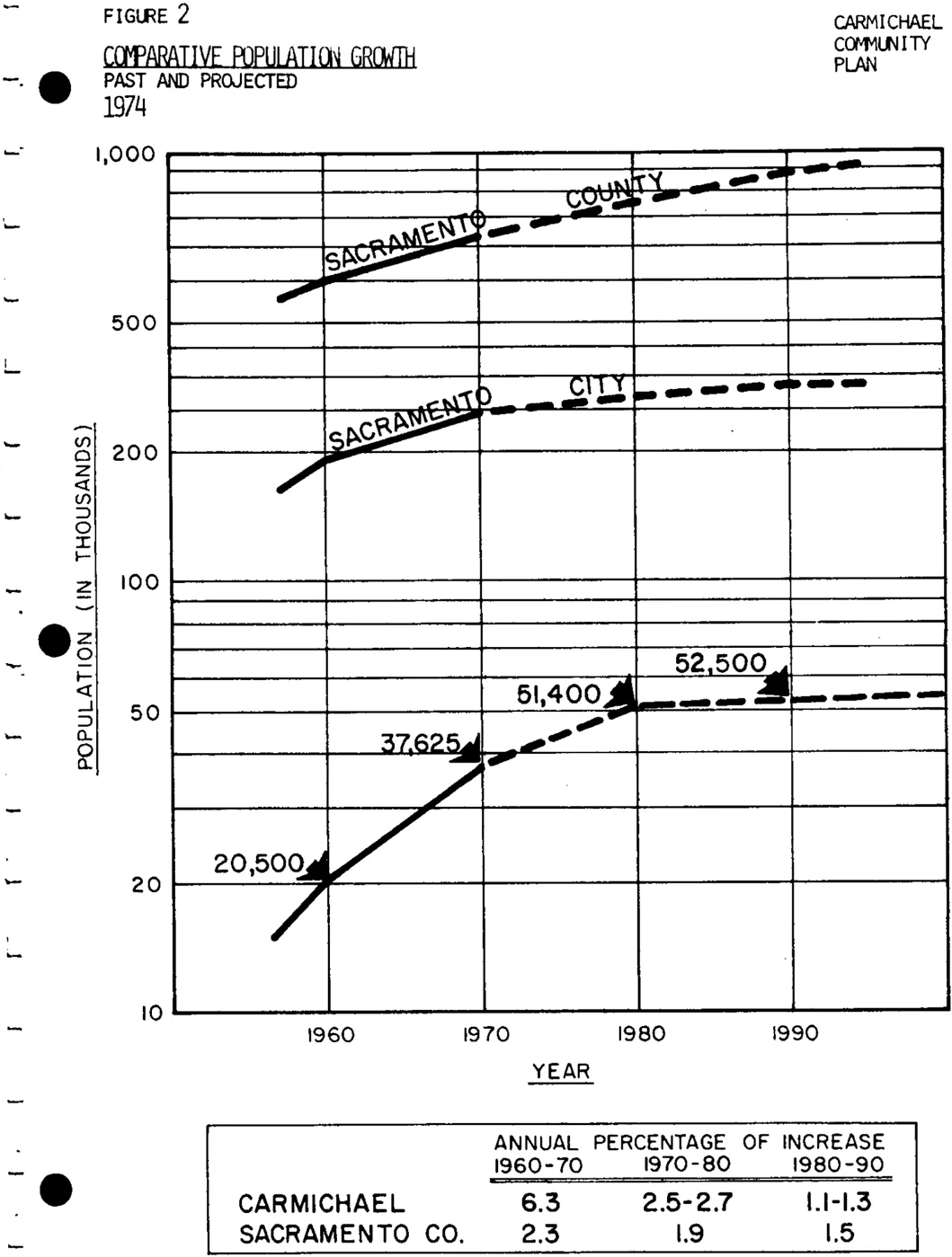
Figure 3 DATA AREAS, 1974
Section titled “Figure 3 DATA AREAS, 1974”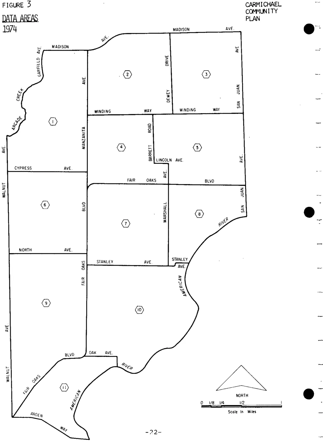
EXISTING LAND USE
Section titled “EXISTING LAND USE”Simply put, the subject of land use deals with the question of how each parcel of land in a given area is presently used, to what uses the vacant lands should be put, and what land uses are inappropriate and should eventually be changed. In January 1972, the existing land uses in Carmichael were recorded. Table 8 lists those areas in acres and percentage of the total. The undeveloped open spaces amount to over 1/4 of the community. Of these 1800 acres, about 1000 acres are small, scattered, partially developed parcels. The remaining 800 acres are those areas which will provide the space for new urban development in Carmichael and significantly affect the direction and character of Carmichael’s future growth. These are the critical areas in the future land use decisions to be made for Carmichael. Figure 4 outlines those areas.
TABLE 7 EXISTING LAND USE, 1972
Section titled “TABLE 7 EXISTING LAND USE, 1972”| LAND USE | ACRES | % OF TOTAL |
|---|---|---|
| COMMERCIAL | 201 | 2.9 |
| General Commercial | 189 | 2.7 |
| Industrial | 12 | .2 |
| RESIDENTIAL | 3,100 | 45.2 |
| Single Family | 2,894 | 42.2 |
| Two Family | 99 | 1.4 |
| 3 & 4 Family | 37 | .5 |
| 5+ Family | 70 | 1.1 |
| PUBLIC/SEMI-PUBLIC | 856 | 12.5 |
| Public/Quasi-Public | 92 | 1.3 |
| Schools | 271 | 4.0 |
| Recreation | 493 | 7.2 |
| OPEN SPACE | 1,791 | 26.1 |
| Pasture | 325 | 4.7 |
| Orchard | 100 | 1.5 |
| Vacant | 1,366 | 19.9 |
| STREETS | 916 | 13.3 |
| TOTAL | 6,864 | 100.0 |
Source: Sacramento County Planning Department.
Commercial
Section titled “Commercial”The existing commercial uses, about 3% of the total land area in Carmichael, are generally scattered in a 2 mile strip along Fair Oaks Boulevard between El Camino Avenue and California Avenue. This relatively small area dominates the visual impact of Carmichael upon the passersby, an impact which is unusually poor when one considers the community assets. This eyesore of Strip commercial development has been overwhelmingly identified as the single most disliked aspect of the community.’ The traffic congestion is acute, the parking facilities inadequate, many buildings are substandard, and the ’visual pollution of garish signs common. A major goal of this plan is to reverse this deteriorating trend in Carmichael’s commercial areas.
Figure 4 MAJOR UNDEVELOPED OPEN AREAS, 1972
Section titled “Figure 4 MAJOR UNDEVELOPED OPEN AREAS, 1972”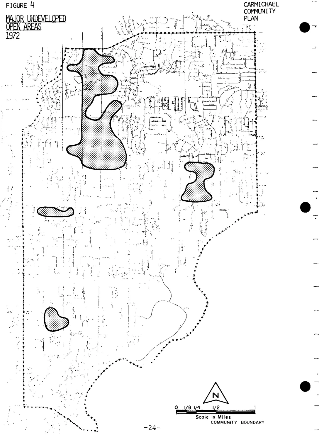
Figure 5 EXISTING COMMERCIAL AREAS, 1972
Section titled “Figure 5 EXISTING COMMERCIAL AREAS, 1972”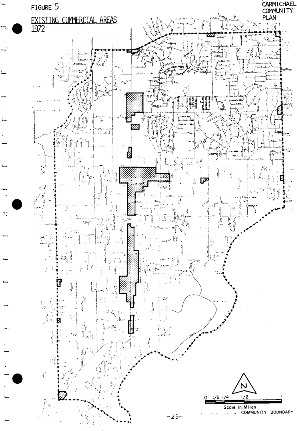
Residential
Section titled “Residential”The residential land uses occupy almost 1/2 of the entire community and 3/4 of the developed areas. In 1970, four-fifths of the population lived in single family dwellings. There are generally three types of residential development in Carmichael today: (1) the old, semi-rural estate areas of 1/2 to 3 acre parcels which are relatively sparsely populated, with many horse pastures and hobby farm activities that make up those areas many people identify as the heart of Carmichael; (2) the modern, single family subdivision of single family detached homes on 7,000 to 10,000 square feet lots generally built up during the population boom of the sixties and; (3) the higher density areas composed of duplexes, four plexes, and apartments. These three areas are generally outlined in Figure 6.
Public/Quasi - Public
Section titled “Public/Quasi - Public”The public and quasi-public land uses fail into three major categories: park and recreation areas, schools and miscellaneous. The park and recreation areas which are presently developed are Carmichael Park and the American River Parkway, including Ancil Hoffman Park. The Carmichael Recreation and Park District owns four sites which are presently undeveloped. These are discussed in more detail in the Parks and Open Space Element of this text.
Schools are self explanatory land use. Sixteen school grounds and four vacant, undeveloped sites are located within the study area. The remainder of public/quasi-public land uses include churches, convalescent hospitals, and buildings and offices tor public agencies such as fire and water districts.
Streets
Section titled “Streets”Streets presently take up 13% of the total community area. When Carmichael is fully developed, this portion will rise to 15% to 19%. This is a substantial portion of the land area in Carmichael and although lower than often found in urban areas, emphasizes the impact the transportation system has on an urban area.
FIGURE 6 EXISTING RESIDENTIAL AREAS, 1972
Section titled “FIGURE 6 EXISTING RESIDENTIAL AREAS, 1972”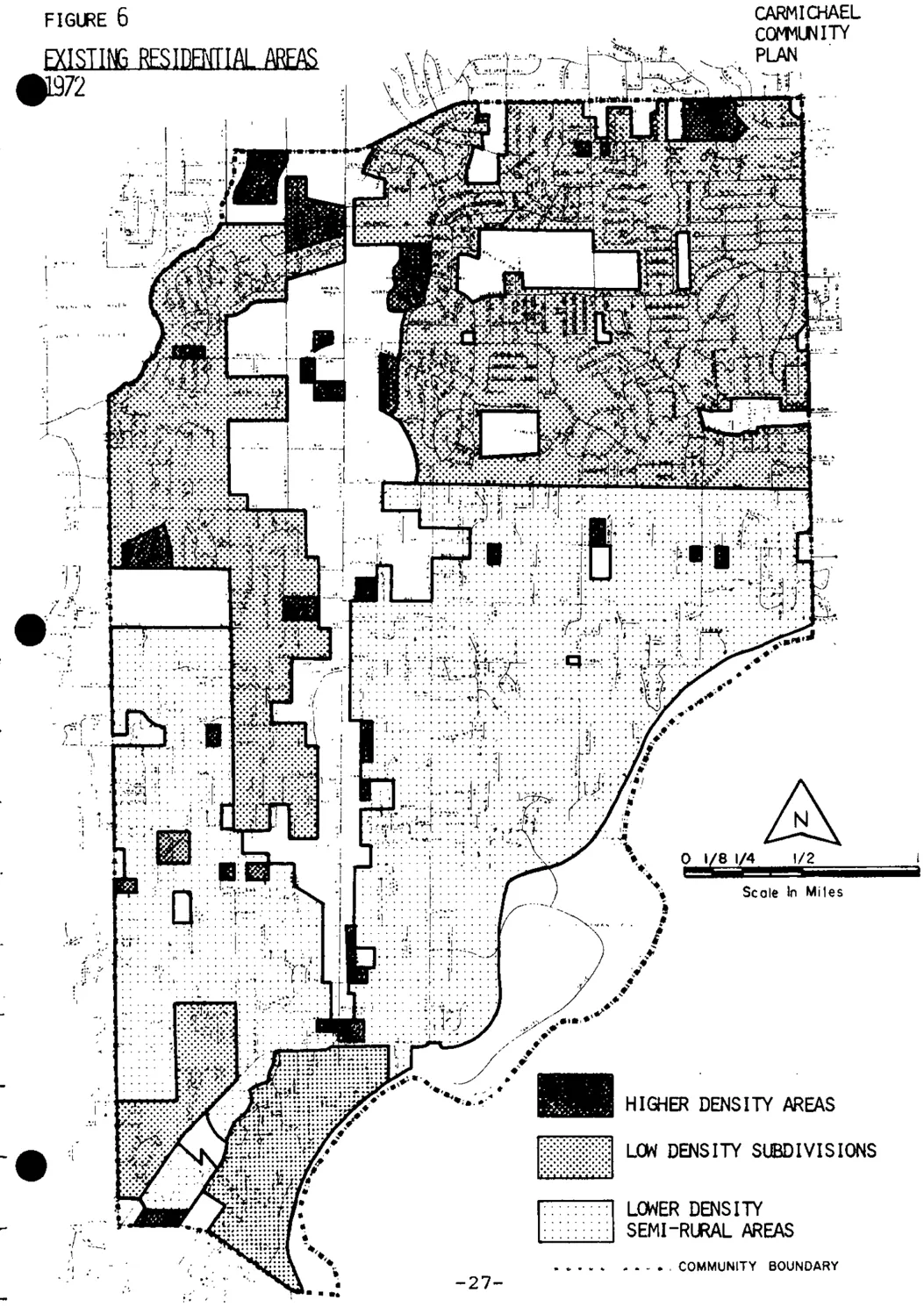
FIGURE 7 PUBLIC AND QUASI-PUBLIC AREAS, 1972
Section titled “FIGURE 7 PUBLIC AND QUASI-PUBLIC AREAS, 1972”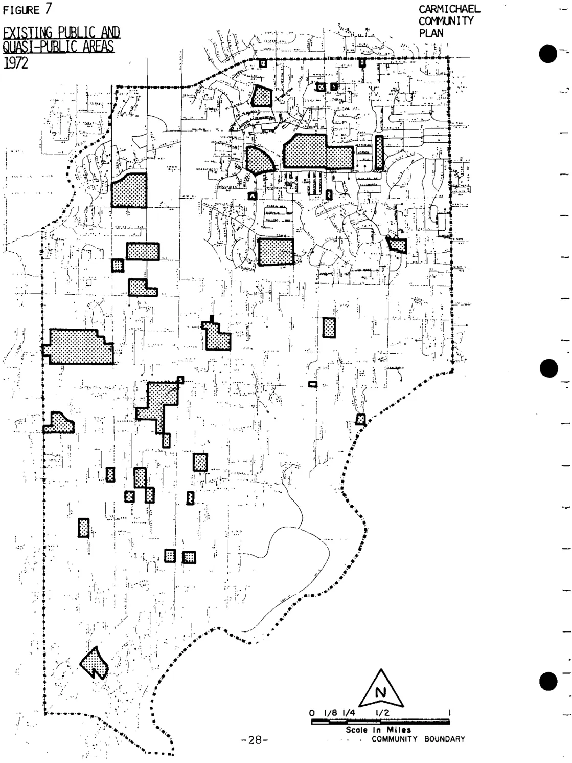
BACKGROUND OF THE LAND USE PLAN
Section titled “BACKGROUND OF THE LAND USE PLAN”During the preparation of the Carmichael Community Plan, two alternative land use maps were submitted, one by the Carmichael Citizens Advisory Committee and one by the Planning Department staff. This happened because the two groups held divergent interpretations of the agreed-upon goals and objectives. Both groups relied upon the goals and objectives as a basic guide, but translated them into differing land use patterns.
Alternative I, submitted by the Citizens Advisory Committee, provided for a lower alternate population than the County General Plan proposes for Carmichael. This alternative provided for large amounts of low-density residential use and limited areas of moderate density residential use. Alternative II, submitted by the County Planning staff, suggested fewer low-density residential areas and larger amounts of medium density residential use with a higher ultimate population. Alternative II also called for a more highly developed circulation system to handle the greater anticipated population of the Community.
The land use plan recommended by the Planning Commission and adopted by the Board of Supervisors has resulted in a compromise between the two alternatives. Both in terms of total acres in various land use categories and ultimate population of the Community, the adopted version strikes a balance between the two original plan alternatives.
Residential
Section titled “Residential”The emphasis of this section is toward locating new higher density residential facilities in the vicinity of existing areas which have adequate circulation facilities to handle increased traffic with a minimum of impact to surrounding areas, and to the preservation of semi-rural neighborhoods. The Plan, as approved January 15, 1975, indicates almost 60.0% of the planning area for residential neighborhoods.
61% of the 4,135 residential acres are typical, low density (RD-5) subdivision areas, while another 14% is proposed for higher density (RD-10, 20, 40) areas. The remaining 25% of the residential areas are indicated for very low density, semi-rural living areas (RD-1 and RD-2). The residential areas shown would house 60,598 people at ultimate development.
Residential density is measured as the number of dwelling units per acre. As the density of an area increases, its character changes. An example of this change would be the difference between a single house on a 5 acre parcel, a subdivision of 20 homes on the same parcel, or an apartment house with 100 units on the parcel. Each use would have a different density and the character of each would be different. A major goal of the Plan is to provide for a distribution of residential uses and densities so as to preserve the desirable character of Carmichael. Defined below are the residential land use designations and a description of their character and densities.
TABLE 8 LAND USE AT ULTIMATE DEVELOPMENT By Acres and Percent of Total
Section titled “TABLE 8 LAND USE AT ULTIMATE DEVELOPMENT By Acres and Percent of Total”| LAND USE | ACRES | PERCENT |
|---|---|---|
| RESIDENTIAL TOTAL | 4,135 | 60.0% |
| Residential Density 1 | 308 | 4.5% |
| Residential Density 2 | 711 | 10.1% |
| Residential Density 5 | 2,539 | 37.0% |
| Residential Density 10 | 214 | 3.1% |
| Residential Density 20 | 190 | 2.8% |
| Residential Density 40 | 173 | 2.5% |
| COMMERCIAL TOTAL | 326 | 4.7% |
| General Commercial | 30 | .4% |
| Shopping Center | 98 | 1.4% |
| Business & Professional | 70 | 1.0% |
| Other Retail | 128 | 1.9% |
| PUBLIC QUASI/PUBLIC | 101 | 1.5% |
| SCHOOLS | 260 | 3.8% |
| PARKS/RECREATION | 605 | 8.8% |
| PARKWAYS & OPEN SPACE | 107 | 1.6% |
| STREETS* | 1,329 | 19.4% |
| TOTAL | 6,864 | 100.0% |
Source: Sacramento County Planning Department
* includes transportation corridor under study.
It should also be noted that the land use designations indicate the maximum density allowed under normal zoning and development conditions. For instance, an area indicated as RD lo can be developed at a lower density if the owner so chooses. At the same time, if an individual chooses to develop his property under the provisions of a zoning district which allows a higher maximum density than the land use plan permitted (i.e. R-2A zoning in an RD 10 area), the project density would be limited by the maximums indicated on the plan.
The lowest residential density proposed, less than l dwelling unit per acre is RD-1. These areas are meant to accommodate single family homes in conjunction with the pasturing of animals, particularly horses. The lots would generally be 2 acres and larger in size. There are 308 acres proposed for this type of residential use.
The plan indicates 711 acres for RD-2. The density would be l to 2 dwelling units per acre. Although hobby farm uses such as in the RD-1, are emphasized, this area would also include large lot estate subdivisions which might not contain agriculture uses.
RD-5 areas are exemplified by the modern subdivisions in northeastern Carmichael. These are volume built, single family detached housing units which are generally owner occupied. The density ranges from 3 to 5 units per acre, although it can be lower. The RD-5 areas proposed could allow for duplexes and apartments given a permissible number of dwelling units per acre. Density would range up to 5 units per acre, but is typically 4.5 per acre. 2,539 acres are proposed for RD-5 in the plan.
RD-10:
Section titled “RD-10:”The land use proposed as RD-10 would allow 6 to 10 units per acre. These areas could have duplexes and townhouses. There are 214 acres proposed in this category: This is typically the density of duplex subdivisions, but is also found in some townhouse and quad-plex developments. In these areas there would be a combination of owner occupied and renter occupied living areas. Some lower density apartment units may also be placed here.
RD-20:
Section titled “RD-20:”The Carmichael Plan proposes the RD-20 land use category to accommodate those land uses typified by apartments and quad-plexes. Maximum density would range from 1l to 20 units per acre. The designated multiple family areas are oriented to existing apartment areas, major transportation corridors and commercial centers. There are 190 acres proposed for this category.
RD-40:
Section titled “RD-40:”RD-40 areas of the Plan would allow 15 to 40 dwelling units, the maximum allowed in unincorporated Sacramento County.. The character and orientation of this area is similar to the RD-20 areas of the Plan with the exception of a higher maximum allowable density, although a feeling was expressed by members of the CCAC that a density higher than 27 units per acre is incompatible with the low density character of Carmichael. Inclusion of RD-40 reflects existing County regulations. There are 173 acres proposed for this category.
Commercial
Section titled “Commercial”In proposals for commercial land uses, the plan emphasizes the orientation of commercial facilities toward the established centers at Fair Oaks Boulevard and Marconi Avenue, Fair Oaks Boulevard and Manzanita Avenue, and Manzanita Avenue and winding Way. A major Business and Professional center is recommended to be established near Carmichael Park on Fair Oaks Boulevard. The gradual development of these centers should be coordinated under the overall design plan so as to provide for unified, attractive centers. The clutter of individual signing should be abandoned in favor of a very few, attractive signs identifying the center and its occupants. Adequate parking and circulation should also be jointly developed to ease the traffic congestion on Fair Oaks Boulevard. The plan proposes 322 acres of Commercial Land Use.
Generally, new commercial development along Fair Oaks Boulevard between Carmichael Park and Sutter Avenue should be prohibited. Existing commercial uses at this location would eventually be phased out through natural deterioration. These plans could halt the spread of additional strip commercial development and serve to orient commercial activity toward established centers. The objective of both plans include solving the problems of traffic and visual clutter along Fair Oaks Boulevard which are the major criticisms of Carmichael.
General Commercial
Section titled “General Commercial”These areas generally include such facilities as building trades service yards and workshops, auto sales and service, lumber yards, and other heavy commercial activities. Normally the uses require larger individual sites and building areas than in a shopping center. These types of uses should be encouraged to group in the same general area. The plan recommends one area of general commercial on Fair Oaks Boulevard between Manzanita and California Avenues, of approximately 30 acres.
Shopping Center
Section titled “Shopping Center”A shopping center is a unified grouping of retail shops and services with convenient parking. They are generally located in major transportation corridors. They should be developed so as to promote a harmonious relationship with the adjacent residential areas. They should be self-contained units rather than long strip developments. The bulk of shopping center areas shown in the plan are existing, although some new areas are proposed on the southeast corner of winding Way and Manzanita, and on Fair Oaks Boulevard near Sutter and near Palm Avenue. 98 acres of this designation are proposed on the plan.
Business and Professional
Section titled “Business and Professional”The business and professional area is a grouping or concentration of complimentary office type uses and limited personal services to allow for the maximum interaction of business between offices in a convenient location for the persons who utilize the services provided.. To achieve this end, the Plan proposes a major business and professional center along Fair Oaks Boulevard in the vicinity of Carmichael Park. The bulk of existing uses in this area are oriented to business and professional activities. Given a general development plan for the area, existing commercial activities in the area would be enhanced while attracting new high quality facilities.1 A second business and professional center is proposed at Fair Oaks and Hollister and another along Fair Oaks between Palm Avenue and El Camino. ’Total area is 70 acres.
Other Retail
Section titled “Other Retail”This category includes light commercial activities not included in shopping centers and business and professional areas, such as convenience centers, specialty shops, and limited retail trade. Any expansion of these areas should be limited so as not to’ intrude into adjacent residential areas. The plan proposes 128 acres of other retail.
Public/Quasi-Public
Section titled “Public/Quasi-Public”Most of the facilities on the maps are self-explanatory and further discussion of their distributions where needed will take place in the public facilities element of this report. Facilities which fail into this category include churches, convalescent hospitals, fire stations and public offices. It is usually difficult to anticipate the location of these types of uses in advance therefore only existing facilities are shown on the future land use plan. Future public facilities proposed for Carmichael must be evaluated on the individual basis, but they are generally compatible with all land uses. Other uses shown on the land use plans such as schools, parks and open space are discussed in later sections.
Planned Development Districts
Section titled “Planned Development Districts”For certain areas, the land use plan contains a Planned Development (PD) designation in addition to the normal land use categories. Since traditional land use designations are sometime unable to provide an adequate guide for sound development, this process is recommended to encourage more innovative and environmentally sensitive development of the land. Developments within these districts are expected to exhibit a high degree of environmentally sensitive design in terms of preserving natural terrain and major trees, well-located buildings, and the provision of useable public and private open spaces. A major objective of the “PD” districts is to provide an incentive to developers in the community to develop the few remaining large areas of open land in Carmichael in a way which will benefit the entire community.
Those areas identified for a planned development district on the land use plan exhibit certain qualities which could best be dealt with under the PD process. This does not imply that other areas are unsuitable for development under the PD process. The areas designated are the major areas of the community requiring the closest concern regarding PD districts.
The purpose of the planned development district is to encourage and provide for:
- More innovatively designed development which is compatible with the physical environment;
- The tailoring of land use and density to the characteristics of the site;
- Flexibility in response to change in demands, tastes, and needs for particular types of land use;
- The development of various types of uses in designated areas which are mutually compatible; and
- Consideration of particular problems or characteristics associated with areas of irregularly shaped lots, and access and parking problems.
The PD districts shown on the land use plan are grouped into two categories: a along Manzanita Avenue from Cypress Avenue north to Madison Avenue; and the Business and Professional Center on Fair Oaks Boulevard from Stanley Avenue north to Carmichael Park. Property in the first area will be put into the (PD) zoning district at the time of development through private initiation of zoning. The second area is proposed to be initiated by the Planning Commission at time of Zoning Consistency hearings.
It is recognized that portions of these areas are presently developed. While the development criteria apply development or redevelopment, it is hoped that some existing development may be revitalized along similar lines.
MANZANITA AVENUE AREA
Section titled “MANZANITA AVENUE AREA”Within this area lie the few large areas of undeveloped land remaining in Carmichael. The manner in which they, as a group, are developed will have a significant impact upon the physical character of Carmichael. In the effort to support the community goals through physical development, change in this area would be best guided through the planned development process. Traffic noise along Manzanita Avenue and the need to prevent the extension of strip commercial development in this area limit the land use options.
General development criteria in this area are as follows:
- Utilization of the Planned Development provisions of the Zoning Code is required unless a waiver is granted by the Planning Commission.
- Adequate transition with surrounding areas and provision for traffic noise abatement shall be achieved through landscaping, fencing, or other physical buffers along project boundaries;
- Grading operations which would significantly alter the topography or vegetation of the site shall be prohibited;
- Mixtures of commercial and residential uses which are designed in a compatible manner may be permitted; and
- Site plan and architectural design which are both innovative and compatible with the semi-rural, pastoral character of Carmichael are encouraged. Use of cluster developments which maximize useable open space for recreation or the pasturing of horses is particularly encouraged.
A variety of land uses are indicated in the planned development district. Deviations from the design standards in the basic zones and from the maximum densities indicated on the land use plan for conventional developments may be permitted. Consistent zoning classifications by land use category are:
- Residential Density Two (2 dwelling units per acre, maximum).
- R-1-B (PD), R-1-A (PD), and R-E-1 (PD) Residential Planned Development Combining Zones.
- R-E-2, and R-E-3 Estate Zones.
- A-1-A General Agricultural Zone.
- Residential Five (5 dwelling units per acre, maximum).
- R-1-B (PD) and R-1-A (PD) Residential Planned Development Combining Zones.
- R-1-B and R-1-A Residential Zones.
- R-E-1, R-E-2, and R-E-3 Estate Zones.
- A-l-A General Agricultural Zone.
- Residential Density Ten (10 dwelling units per acre, maximum)
- R-2-A (PD), RTH (PD), R-2 (PD), R-1-B (PD), and R-1-A (PD)Residential Planned development Combining Zones.
- CC, Convenience Center Zones.
- RTH, R-2, R-1-B, and R-1-A Residential Zones.
- A-1-A General Agricultural Zone.
- Residential Density Forty (40 dwelling units per acre, maximum).
- R-3 (PD), R-2-A (PD), R-2 (PD), R-1-B (PD), R-1-A (PD) Residential Planned Development Combining Zones.
- BP (PD), and CC, Commercial Zones.
- R-3, R-2-A, RTH, R-2, R-1-B, and R-1-A Residential Zones.
- A-1-A General Agricultural Zone.
- Shopping Center Commercial
- SC (PD), LC (PD), BP (PD), CC (PD), and R-3 (PD) a. Planned Development Combining Zones.
- SC, LC, and BP Commercial Zones.
- Other Retail Commercial
- LC (PD), BP (PD), CC (PD), and R-3 (PD) Planned Development Combining Zones.
- LC and BP Commercial Zones.
BUSINESS AND PROFESSIONAL CENTER
Section titled “BUSINESS AND PROFESSIONAL CENTER”A Business and Professional Planned Development District is proposed on both sides of Fair Oaks Boulevard from a projection of Whitney Avenue at Carmichael Park on the north to Stanley Avenue on the south. This area is becoming an informal business and professional center of Carmichael. The location and potential is good; but without a coordinated, cooperative approach to future development and redevelopment, the success of the center will be limited. Problems which presently exist and which will continue to exist if the area is not properly planned are:
- Poor circulation
- Inadequate safe parking
- Non-existent or sporadic landscaping
- Unattractive signing not in keeping with a quality business and professional area
- Small, irregularly-shaped parcels
In order to implement a solution to these problems, a development plan will be developed for this planned development district in cooperation with the property owners and businessmen in the area which will provide criteria for:
- building site location
- parking areas
- landscaping
- general architectural design standards
- signing
This development plan will be considered by the Planning Commission at time of zoning consistency for the Carmichael area. At that time, the Planning Commission will initiate the LC(PD) or BP(PD) zones for the area covered by the development plan when appropriate amendments to the County Zoning Code have been adopted so as to allow such initiation.
RECOMMENDATIONS
Section titled “RECOMMENDATIONS”The plan approved by the Sacramento County Planning Commission contains recommendations which are intended to establish a positive guide for zoning and land use decisions in Carmichael. Upon adoption of the plan by the Board of Supervisors, the following policies will be established and implementation of them will be sought:
- Holding zoning consistency hearings to bring the existing zoning into conformance with the proposals of the adopted plan.
- Retain those areas exemplifying the semi-rural character of Carmichael such as south and east of Fair Oaks Boulevard.
- Limit duplex, four-plex, townhouse, and apartment developments to those areas where they presently exist, that are compatible with the surrounding area, and that have adequate transportation and recreation facilities.
- Eliminate inappropriate, unused multiple family residential and commercial zoning in Carmichael in accordance with the final plan.
- Amend the R-1-B zone so as to prohibit development incompatible with the intent of the zone which is to allow for a variety of low density and semiagricultural uses in the same general area.
- Amend the R-E-3 and R-E-2 zoning districts so as to allow the boarding of horses.
- Deny further strip commercial zoning.
- Require “PD” combining zones designated in those areas of significant community importance.
- Adopt new standard County land use designations to more accurately describe the type and density of land uses.
TRANSPORTATION
Section titled “TRANSPORTATION”GOAL: TO DEVELOP AN EFFICIENT FULLY INTEGRATED AND ECOLOGICALLY BALANCED TRANSPORTATION AND CIRCULATION SYSTEM
Transportation, the mean by which people and good are moved from one place to another, in part, determines the physical structure of an urban area, the density and intensity of land uses, the rate of urban growth, and the social and economic viability of the community. Common modes of transportation include cars, motorcycles, trucks, public or mass transit in the form of airplanes, trains and busses, bicycles, horses and walking.
Four interconnected, major community transportation problems exist in Carmichael. These problems include congestion on local arterial streets during peak traffic periods, a low level of public transit service, the proposed construction of two state freeway routes through Carmichael, and the lack of safe pedestrian, equestrian, and bicycle paths.
During four hours out of the day, local arterials are congested with heavy commuter traffic. Local traffic congestion will continue to occur unless alternatives to the automobile are made available. In most cases, the car must be replaced wherever possible to alleviate local traffic congestion and to lower air and noise pollution levels. This implies designing a transportation system that provides for and encourages car pools, bicyclists, pedestrians, and mass transit as well as accommodating the automobile in individual use.
Present transit needs are not being met in Carmichael. A common complaint among residents is that the bus service area and schedules are not convenient enough for commuter and shopping use. The new Sacramento Regional Transit system is beginning to improve service and enhance the use of the bus. In the next few years, Sacramento Regional Transit will add to the transit system several new routes on Fair Oaks Blvd., Gibbons Drive, Winding Way and Madison Avenue. If transit use is to increase, transit facilities must be well designed and located within easy access of persons desiring to use them. Frequency of service must also be expanded if it is to capture a significant percentage of tripmakers.
In recent years, bicycles have become a popular mode of transportation. By the development of bicycle paths, bicycle ridership in Carmichael can be increased. At present, several bicycle routes exist or are in the process of completion on the following streets: Fair Oaks Blvd. between Walnut and California, Walnut Avenue, California Avenue, Marconi Avenue, Winding Way between Walnut and Manzanita, Cypress Avenue, and Lincoln Avenue. Horses are a popular form of recreational transportation in Carmichael and must also be safely accommodated. Walking is also an important transportation mode which must be safely accommodated.
STREETS AND HIGHWAYS
Section titled “STREETS AND HIGHWAYS”The network of streets having a width of 80 feet or more are referred to as major streets and highways. There are a number of sub-categories within this roadway network including freeways, expressways, thoroughfares, and major arterials. Local streets are those streets having a width of less than 80 feet, typically 42, 54, or 60 feet. The major streets and highways in Carmichael are shown on Figure 8.
Freeways
Section titled “Freeways”These are limited access, inter-urban roads, above, below or at grade designed to provide for an uninterrupted flow of large volumes of traffic. Two interstate freeways serve the Carmichael area, Interstate 80 on the north and U.S. Highway 50 (El Dorado Freeway) on the south.
The major streets, particularly Fair Oaks Boulevard, in Carmichael and Arden-Arcade are presently at or approaching capacity at peak travel period. In addition, Carmichael residents must go to Sunrise Boulevard, or Watt Avenue in order to cross the American River. This further aggravates the traffic congestion when most commuter traffic into and out of Carmichael is funnelled on to a single bridge crossing or on to those local streets which are not designed for heavy traffic to reach I-80 and I-880 to the north.
The negative impacts of one or two additional freeways are numerous. New freeways provide better access, hence an increased population. This fast growth could destroy the qualities which make Carmichael a pleasant place to live. Five or ten minutes additional commuting time to work may be a cheap price to pay to maintain a positive living environment.
A recent study in Seattle has shown that a new freeway initially provides a shorter commuter time, but in the long run it encourages people to travel more than they did previously*. This situation has led to a rapid overuse of the private auto and increased total traffic.
The acquisition of the freeway routes eventually leads to removal of the subject rights of way from the tax rolls and elimination of possible alternate uses which might be more desirable.**
* “vehicle Characteristics of Fuel and Travel Time on Urban Arterials and Freeways”, Roy B. Sawhill, James Matteson, and Jerome W. Hall, University of Washington, Highway Research Record#314.
** On December 23, 1974, the Board of Supervisors of Sacramento County voted to remove from freeway status both routes 143 and 244 in the Carmichael community. In February 1975, the Board established a Task Force to study the above route locations for a Transportation Corridor for modes of transportation as alternatives to the automobile. The Task Force has chosen a consultant to assist in its study, but has not yet completed its report on the project.
FIGURE 8: Major STREETS AND HIGHWAYS, 1974
Section titled “FIGURE 8: Major STREETS AND HIGHWAYS, 1974”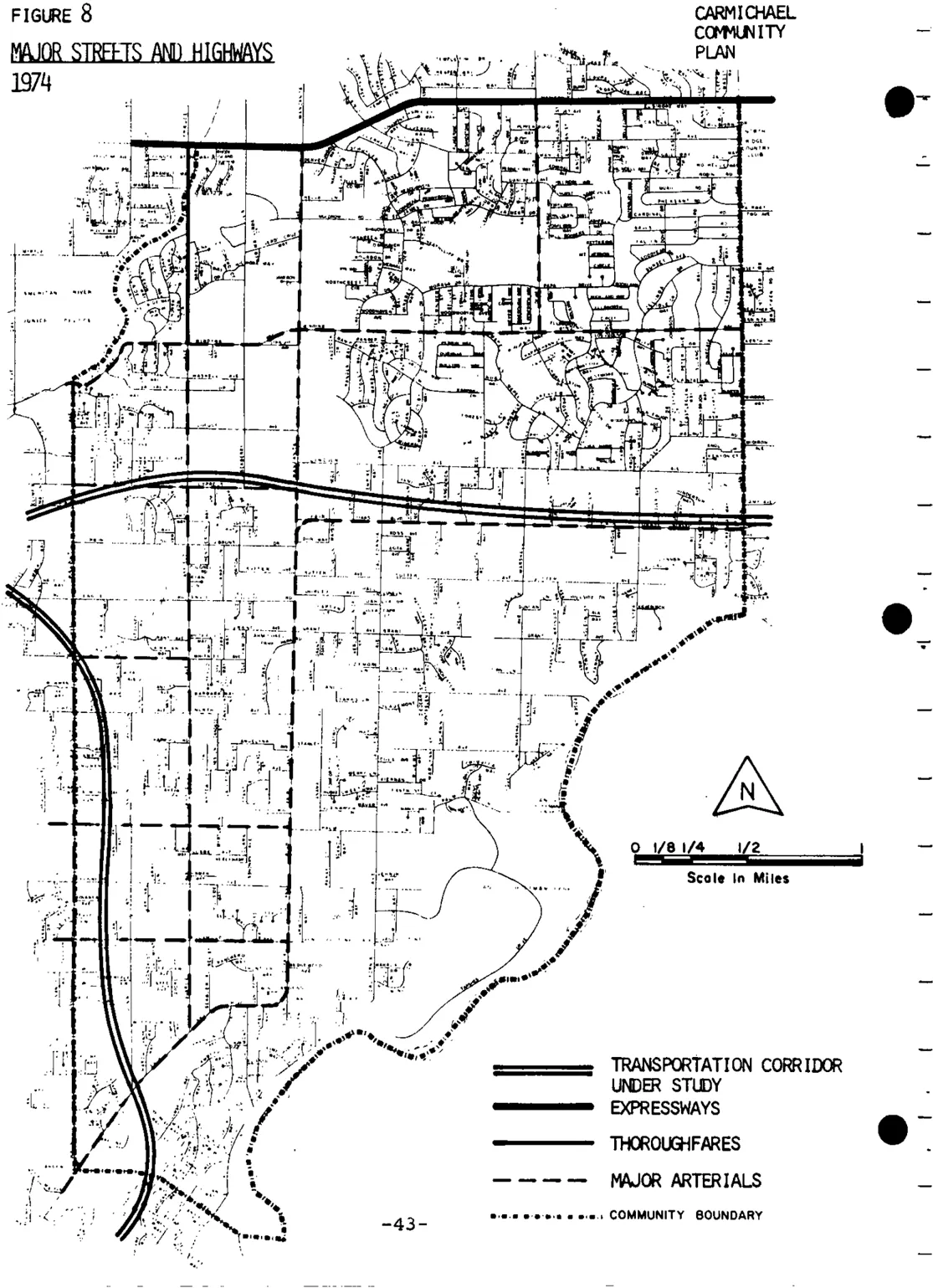
TABLE 9 1975-80 FIVE YEAR COUNTY ROAD IMPROVEMENT PROGRAM FOR THE CARMICHAEL AREA
Section titled “TABLE 9 1975-80 FIVE YEAR COUNTY ROAD IMPROVEMENT PROGRAM FOR THE CARMICHAEL AREA”| PROJECT & YEAR | LIMITS OF PROJECT | TYPE OF IMPROVEMENT |
|---|---|---|
| 1975-76 | ||
| 1976-77 Fair Oaks Blvd. |
Corridor traffic signal improvements including signal at Grant Avenue | |
| 1977-78 Fair Oaks Blvd. |
Garfield Ave. to El Camino | Left turn lanes |
| 1978-79 Madison Ave. |
Auburn Blvd. to Sunrise Blvd. | 6 lanes divided |
| 1979-80 Gibbons Drive Whitney Ave. Sue Pam Ave. Grant Ave. |
Walnut Ave. to Fair Oaks Blvd. Garfield Ave. to Fair Oaks Blvd. |
2 lanes 2 lanes |
Source: Sacramento County Department of Public Works
It is still an open questions as to whether or not the loss of property tax revenues through land acquisition by the State is offset by increasing land values (and hence property taxes) adjacent to the freeway rights of way.
The environmental impacts of freeways are great. Since the freeways would encourage the continued use of automobiles, the problems of air and noise pollution would increase. Both routes would require a bridge over the American River, an area of outstanding natural beauty. The construction of these bridges would disturb that natural beauty and this is too high a price to pay for better transportation facilities.
The conclusions reached in the report written by the Interdisciplinary Systems Group at UCD indicate that a combination of staggered work hours, better bus service, and increased driving and parking costs would reduce automobile traffic to a point disciplinary Systems Group at UcD indicate that a combination of where the existing system would be more than adequate to handle all existing and future traffic.
The Carmichael Citizens Advisory Committee has recommended that the freeways not be built for most of the above mentioned reasons which are based upon a desire to maintain community identity and to preserve the semi-rural character of Carmichael.
Expressways
Section titled “Expressways”Expressways are major inter-community streets with limited access, median dividers, four to six lanes, traffic lights, and frontage roads as needed. Madison Avenue, the northern boundary of the Carmichael Study Area, is the only existing expressway in the plan area. One alternative to the construction of the two freeways would be expressways. These streets would provide local traffic service without creating the major impacts of freeways. Special bus and bicycle lanes could be more easily provided.
An existing problem with the Madison Avenue expressway is traffic congestion at Manzanita and San Juan Avenues. This will be relieved somewhat with improvements to a full six lanes in the near future.
Thoroughfares and Major Arterials
Section titled “Thoroughfares and Major Arterials”These streets complete the major streets and highways network. Thoroughfares and major arterials are virtually identical with the exception that thoroughfares may be divided and are somewhat wider. Both are designed for four lanes, allow direct although restricted access, and do not require frontage roads. Generally, these streets collect traffic from residential streets and distribute it to expressways and freeways.
The only thoroughfare in Carmichael is Garfield Avenue between Madison Avenue and Winding Way. No others are anticipated.
The major arterials form the framework of the street network of Carmichael. Among the arterial streets are Fair Oaks Boulevard, Winding Way, Dewey Drive, Cypress, Marconi, El Camino, Garfield, Walnut, Manzanita, and San Juan Avenues. Major emphasis should be placed upon upgrading and maintaining these streets at as high a level of development as necessary to carry traffic through and within Carmichael.
Local Streets
Section titled “Local Streets”Local streets are generally from 60 to 42 feet in width, some in Carmichael are as narrow as 18 feet. The local streets are basically residential access and feeder streets which move cars from homes to major streets. Many are class “A” streets, with streets, curbs, gutters, and sidewalks. Most others are Class “c” s with only dirt ditches. It is recommended that all local streets be maintained as class “c” streets, with the exception of streets in new subdivisions, so as to retain the semi-rural atmosphere in those areas where class “c” streets now exist. Local street improvements should include roadway surface improvements and widening up to 42 feet to safely accommodate equestrians, pedestrians, bicyclists, and emergency parking, Development of sidewalks are not encouraged in the large lot areas.
Significant problems exist relative to three local streets - Jan Drive, Marshall Avenue and Grant Avenue. Jan Drive dead ends at its western terminus approximately 800 feet east of Manzanita Avenue. There is considerable neighborhood sentiment that if this street is continued through to Manzanita Avenue the traffic will increase greatly, thereby jeopardizing the safety and privacy of the people living along the street. It is the opinion of the Planning Department that this will have no more adverse environmental impact than any other neighborhood street. Jan Drive was stubbed out with the understanding that it would be extended to complete the neighborhood circulation pattern. The plan recommends that Jan Drive be incorporated into the development of the land to the west. Although it may not become a direct through street to Manzanita Avenue or maybe extended north to Rampart Drive, the plan recommends that it not remain a dead end street.
Marshall and Grant Avenues both dead end into ravines in the eastern portion of Carmichael. Future plans indicated bridges to be constructed over these ravines, thereby creating a more efficient circulation system in this area. Two problems exist with this proposal. Bridges would most likely ruin the natural stream areas over which they would be constructed. Secondly, the area is built up residentially about as much as it is expected to ever be, and there seems to be little desire among the areas’ residents to have these bridges constructed. It would not be an acceptable procedure to make these improvements which are expected to benefit only the immediate neighborhood if that neighborhood does not want it. These projects should be re-evaluated in that light.
TRANSIT
Section titled “TRANSIT”The Sacramento Regional Transit District provides the only mass transit service to Carmichael residents. The Sacramento Regional Transit system primarily accommodates inter-community and commuter travelers. It is rather limited for intra-community travel due to limited coverage of the community, limited bus frequencies, and lack of night and weekend service.
Six bus lines operated by the Sacramento Regional Transit presently serve the Carmichael area. These 1ines operate 7 days a week from 6:00 AM to 10:00 PM, Monday through Friday, and to 6:00 PM Saturdays and Sundays at regular intervals between Carmichael and downtown Sacramento. Present Regional Transit busses operate over the following routes in the community of Carmichael: Madison, Fair Oaks, Winding Way. Manzanita, Marconi, El Camino, California and Shelfield. In the future, routes are planned to serve even more of the community on Garfield, Winding Way, Gibbons, and American River Drive.
Bus transit has only captured a minor share of the trip making. In Sacramento County, bus transit makes up only about 3% of total trips.
One alternative which could improve the quality of transit service is to provide a combined system of bus transit and a community supported dial-a-bus system. While bus transit could primarily meet the needs of commuters and inter-community travelers, a dial-a-bus system could better meet the needs of citizens with limited mobility (i.e. the handicapped and elderly citizens).
Presently, several financing sources are available to support transit service in Carmichael. These include:
- Transportation Development Act of 197l (State SB 325)
- Urban Mass Transportation Act of 1970 (Federal)
- Passenger fares
- Local funds - additional unrestricted local sales tax revenue derived from SB 325; revenue sharing monies; general fund appropriations.
BICYCLES
Section titled “BICYCLES”The bicycle is a viable alternative to the automobile. It is less costly than the automobile, promotes physical fitness, and does not cause air or noise pollution. The bicycle can decrease automobile traffic flow considerably by replacing the car on short trips to commercial and service areas.
Figure 9 Regional Transit Bus Route, 1975
Section titled “Figure 9 Regional Transit Bus Route, 1975”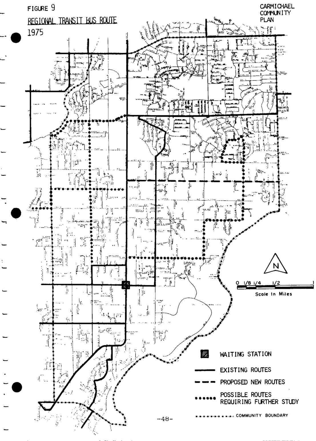
In August 1973, the Sacramento County Public Works Department conducted a survey to investigate existing bicycle patterns and to learn of people’s reaction to accepting the bicycle as an alternative to the automobile. This study concluded that more people would use bicycles if bicycle lanes were provided.
Sacramento County has encouraged the use of the bicycle by construction of bicycle paths which are separated from motor vehicle lanes and on street bikeway projects. Such bicycle paths are attractive and reduce bicycle vs. motor vehicle accidents. Types of bicycle facilities which are constructed include:
Class I: (Bike Trail or Bike path)
Section titled “Class I: (Bike Trail or Bike path)”A completely separated facility designated for the use of bicycles.’ The facility is separated from roads used by motorized vehicles by a physical space, berm, fence, or other barrier. Pedestrians are normally allowed use of the facility. Crossflows by vehicular and pedestrian traffic are kept to a minimum.
Class II: (Bike Lane)
Section titled “Class II: (Bike Lane)”A lane within a street or roadway designed for the one-way use of bicycles. It is an on-street facility with signs, striped lane markings, and pavement legends.
Class III:(Bike Route)
Section titled “Class III:(Bike Route)”A shared, on-street right-of-way delineated by signs and optional legends stenciled on the pavement. A Class III bike route shares its through traffic right-of-way with motor vehicles or pedestrian traffic.
Providing for increased bicycle use will bring several benefits to Carmichael. Bicycling can help establish a community identity. It will help preserve and accent Carmichael’s Semi-rural character. It will also offer an alternative to the automobile. Carmichael has a unique opportunity to develop an extensive bicycle system in the greenbelt areas of the community. Figure 10 indicates bicycle routes adopted by the Board of Supervisors as part of the Sacramento City-County Bikeway Master Plan in Carmichael. These routes should provide safe pathways for pedestrians as well as for bicyclists.
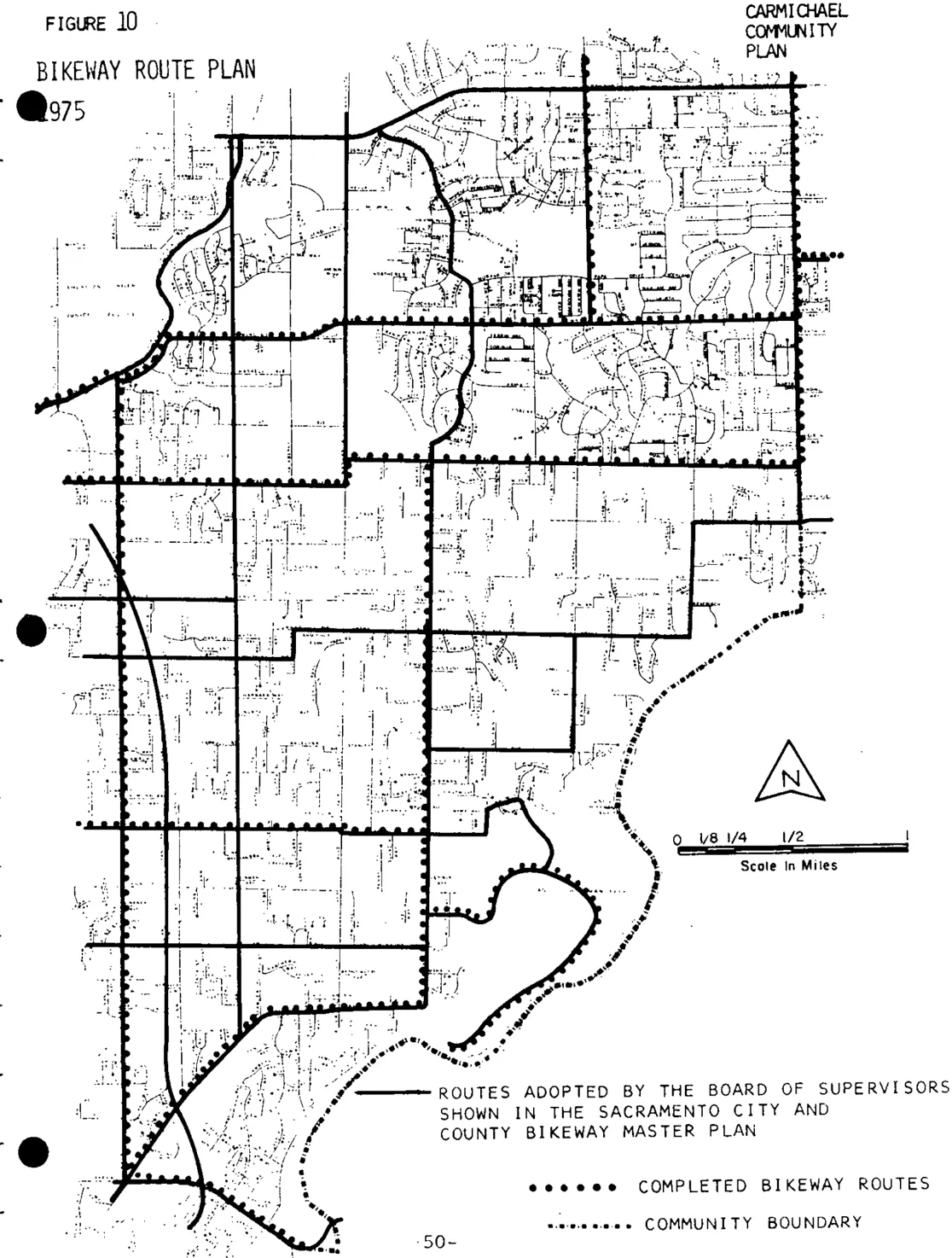
Horses
Section titled “Horses”The horse has figured dominantly in the history and development of Carmichael and has a significant part in present life in the community· The whole character of the southeast quadrant of the community and much of the west side of the area is shaped by large lots maintained at least in part for horses and other domestic animals.
If horses are ridden now, it must be on public streets alongside auto traffic or on private land. There is little or no trail system except within the American River Parkway or Hoffman Park.
A trail system utilizing both on and off-street routes has been studied by interested members of the Citizens Advisory Committee and considered for inclusion in the Carmichael Plan.
Although the plan recognizes park, parkway, and natural areas, trails through most of these areas have been discouraged because of the fragile nature of the growth in those areas. Therefore, it is recommended that the plan not include a map of horse trails in the community until public hearings can be held to consider this as an amendment to the plan.
RECOMMENDATIONS
Section titled “RECOMMENDATIONS”To improve and enhance Carmichael’s transportation and circulation system, the following policies will be established and implementation of them will be sought:
- Request public agencies to consider alternative modes of mass transportation other than only freeways and buses.
- Create a Citizens Committee to advise the Sacramento Regional Transit District on community transit needs in Carmichael, and to act as a liaison between the community and the Department of Public Works in matters concerning locally determined traffic problems.
- Further improve the quality of bus service by increasing the number of routes, hours of operation, and the frequency of service (buses/hour).
- Establish pathways for non-motorized modes of transportation on all collector and arterial streets in Carmichael.*
- Make a study of traffic problems in Carmichael with the participation of the Community Council along with Sacramento County Public Works, California State Division of Highways, Environmental Council of Sacramento and SRAPC.
- Adopt County-wide noise control regulations.
- Design the streets and highways through scenic areas in character with the natural surroundings.
- Reevaluate the proposed bridge on Marshall Avenue in light of possible environmental damage and neighborhood opposition.
- Reduce the use of the automobile by providing preferential lanes for buses, increased parking charges, and restricted movement of vehicular traffic in commercial centers to encourage a more balanced, less costly transportation system.
- Investigate the possibility of developing a dial-a-bus or mini bus system for senior citizens and non-drivers in conjunction with the normal public transit service.
- Delete State Freeway Routes 143 and 244 from the Sacramento County streets and highways system in favor of alternative transportation modes.
- Install class “A” street improvements on those portions of Walnut Avenue, Garfield Avenue, Fair Oaks Boulevard, Dewey Drive, San Juan Avenue, Marconi Avenue, El Camino Avenue, Engle Road and Manzanita Avenue not presently developed to Class “A” standards.
- Allow the orderly completion of Jan Drive with the understanding that it not become a major arterial through a residential area.
- Adopt as part of the Carmichael Plan the appropriate routes approved and adopted as part of the Sacramento City-County Bikeway Master Plan and adopt its text by reference.
- Consider and evaluate proposals for equestrian trails in the community to be adopted as an amendment to the plan.
*This will include bikeways, horses and pedestrian traffic, and elderly people, all of whom have no protection on streets in the community.
RECREATION AND OPEN SPACE
Section titled “RECREATION AND OPEN SPACE”GOAL: TO PROVIDE A WIDE RANGE OF RECREATIONAL ACTIVITIES AND FACILITIES FOR THE COMMUNITY.
GOAL: TO MAINTAIN AND PRESERVE THE VALUABLE NATURAL AND HISTORICAL RESOURCES OF CARMICHAEL.
The acquisition and maintenance of adequate recreation and open space areas by public agencies has long been a difficult but necessary job. It has been difficult because expenditures for these kind of facilities (parks, nature areas, etc.) can become a visual focal point for taxpayers’ outrage over increased governmental spending since they are so readily identifiable, unlike expenditures for administration, etc. Also, it has been difficult because there are so many types of open space that the desirable levels of all types of open space in a given urban area are very costly.
BENEFITS OF OPEN SPACE
Section titled “BENEFITS OF OPEN SPACE”Open space provides numerous benefits for people, particularly in urban areas.* Psychological and social stress, as a result of overcrowding in urban areas, can be reduced with adequate open space. Open space, both developed (parks) and undeveloped provide people with the chance to see and experience an uncrowded and relaxing atmosphere.
*Note: The open space benefits have been identified in the BENEFITS OF OPEN SPACE IN URBAN AREAS by Yvonne L. Hunter, Interdisciplinary Systems Group. August 1973.
Open space acts as a control relative to the maximum population of an area. Should Carmichael develop beyond its natural carrying capacity, the quality of the living environment will diminish. This is neither desirable nor necessary. Given a combination of developed and open areas, Carmichael’s maximum population can be maintained at a livable density.
Retention of ground water recharge areas is another important benefit of natural open spaces. As land is developed, more water is concentrated into small areas as it runs off impervious surfaces such as roofs and pavement. The open ground, which recharges groundwater supplies, is also diminished by development which means the increased runoff has less-opportunity to soak into the ground. This could result in an increased need for the importation of water and a higher potential for water erosion.
Urban developments affect weather in the form of increasing heat which is both retained and generated by buildings, pavement, and cars. Conversely, more open space and vegetation leads to a cooler, less noisy environment. Recent studies have also demonstrated that vegetation and open space act as a sink for air pollution, since certain types of plants consume or convert air pollutants harmful to human beings. The retention and provision of open space in urban areas can significantly reduce air pollution in the immediate area.
New studies* on economic benefits show that in many cases it is economically beneficial for a governmental agency to acquire open space rather than allow it to develop and then be required to provide necessary urban services (police and fire protection, schools, etc.). Although residential areas generally pay a high level of property taxes, they also demand the largest amount of Services. It has been shown from a cost/revenue standpoint that the most economical lands are agricultural, upon which-taxes are paid but very little in the way of services are required. Some open spaces in Carmichael fall into a similar category.
*Livingston and Blaney. Open Space Versus Development: Palo Alto Foothills Environmental Design. 197_.
Sewell, John; Poitras, Ronald; and Husbands, Victor P., The Economics of Preserving Agriculture in Ventura County. The Ventura County Planning Department, 1970.
Stanislaus Land Use Workshop, “The Fiscal Impact of Alternative Land Use in Stanislaus County, 1973.
OPEN SPACES TO BE PRESERVED
Section titled “OPEN SPACES TO BE PRESERVED”There are at least six major types of open space presently existing in Carmichael which require preservation. They are active recreation areas (parks and school playgrounds), passive recreation areas (undeveloped, publicly owned open space), natural resource areas (natural streams, major tree groves), scenic corridors (Gold Rush Parkway), sites of historical significance, and unique, semirural residential areas.
Active Recreational Open Space
Section titled “Active Recreational Open Space”As a general rule, a community park is needed for every 25,000 to 30,000 people. Neighborhood parks are smaller facilities approximately 7-8 acres in size, which are within safe walking distance of children from their homes. There should be a neighborhood park for every 4,000 to 5,000 people, The above described park needs are based upon generally accepted park standards of 2 acres of neighborhood parks for every 1,000 people, and 1.5 acres of community parks (at 40 to 60 acres per park) for every 1,000 people. This combined standard of 3.5 acres per 1,000 people in Carmichael indicates an eventual need for 2 community and 10 to 14 neighborhood parks, depending upon the projected total population and park sizes.
The Carmichael Recreation and Park District presently has two community parks (Carmichael Park and the undeveloped Del Campo site), six neighborhood park sites, two subneighborhood (mini) park sites, and three joint development school projects, all totaling over 150 acres. In addition, the Arcade Creek Park District owns a third community park site, the Arcade Creek Community Park, and the Mission Oaks Park District has purchased a neighborhood park site in the southwestern corner of Carmichael. The Community Plan recommends that two additional neighborhood parks be purchased in order to complete the park system within Carmichael. Figure 11 illustrates the park sites presently under public ownership, numbered in order of priority for development. The approximate locations for the additional two sites recommended by the Plan are also shown.
It is recommended that the ambitious acquisition policy of the past several years continue until the basic park system shown in Figure 11 is entirely in public ownership. Development of park sites should not take place at the expense of the acquisition program. When development of a neighborhood park does take place, it should reflect the needs and desires of the neighborhood residents. Some parks may remain as natural open space while others may have turf, playgrounds and baseball diamonds. The level of development should be determined by a consensus of neighborhood opinion and professional judgments.
The highest development priority involves the five original sites owned by the Carmichael Recreation and Park District. Carmichael Park (1), which for years has been the only developed site in the Community, has been heavily used and should be redesigned and redeveloped to give better automobile access as well as make better use of space now consumed by roadways and non-recreational lands. Del Campo Community Park (2) is of highest importance in terms of development, so as to relieve some of the use pressure on Carmichael Park. Schweitzer Grove (3) is also high on the development priority list; when developed, the grove of trees should be maintained in a natural state, while the western half of the site may be developed with needed facilities. The Bird Tract (4) and Stollwood (5) sites are subneighborhood parks which should be developed and maintained with the minimum of expense.
The Cardinal Court site (6) and the Palm Avenue site (7) are both greatly needed. Both park sites have large populations living within their serviceable areas and are located at some distance from other parks. The site on Kenneth Avenue (8), on the other hand, is not greatly needed, since the southeast portion of the community is relatively sparsely populated and has much private open space. This site is ranked at relatively high priority due to Park District activities, rather than community need.
The area between Dewey Drive and Manzanita Avenue is without a proposed neighborhood park. While Del Campo Park is slated for this area, a community park does not fulfill the same needs as a neighborhood park. The nature area at Thomas Kelley School (9), a joint development project of Carmichael Park District and San Juan School District, will partially fulfill this need. Another joint development project is located at the site of the original Carmichael School (10), which was recently destroyed. This development agreement will cost the park district little money and it is an appropriate site for a neighborhood park.
The northwestern portion of Carmichael lies within the Arcade Creek Park District (formerly the Del Paso Park District), and until recently has had no parks. That district now owns the Arcade Creek Community Park site (11), located adjacent to Garfield Avenue on an abandoned County sewage treatment site which includes part of the Arcade Creek Parkway.
The Maple Lane site (12), the Shelfield site (13), and the Hollister site (14) are all properties sold by the school district to the park district when it became evident that schools in those locations would not be needed. Although all are appropriate sites for neighborhood parks, they are ranked relatively low in terms of development priority, either because there are other parks sites near to them or because population density within their service area is low .
A portion of the Barrett School grounds (16) is the subject of a joint development agreement between the school district and the Carmichael Park District. Its location near the more desirable Jan Drive neighborhood park site places it near the last on the development priority list, but it will be difficult for the area to be used for anything other than a park.
The Grant Avenue site (17) is a beautiful open space area. Development of this park is postponed indefinitely in deference to the wishes of the neighboring residents. The Park District has agreed to consult with all residents in the immediate area before any development of the park property is proposed. In the meantime, the land will be kept as open space and as a 4-H tree farm project area.
The Jan Drive site is an unneeded school site proposed for acquisition as a neighborhood park. It is relatively well situated and is in the center of a presently populated area which is expected to grow in the future. The site is 14 acres in size. Only half that is necessary for an adequate neighborhood park and the Planning Department recommends that only seven acres be purchased. The CCAC recommends that the entire site be purchased. The school district is considering using the site for a cultural and fine arts center, in which case none of the property would be available for park use.
The North Avenue site is necessary to provide a minimum system of neighborhood parks. Although its close proximity to Carmichael Park means that the area is presently provided with some recreational opportunities, Carmichael Park should not remain a permanent substitute for a local neighborhood park.
In addition to the park sites, school grounds are also used for active recreation. Some school grounds and a few facilities are open after school hours, but not to the extent necessary to Serve the community. Tennis courts at the high schools are not lighted and ,consequently, night tennis is channeled to overcrowded Carmichael Park. Additional tennis courts and other facilities should be lighted so as to provide the maximum amount of recreational use for the community. This use of school grounds is particularly important in areas not adequately served by the park system.
Vandalism is the major drawback to leaving schools open after hours. This is a very real problem and threatens to deprive the entire community of recreation facilities due to the actions of a very few. A solution to this problem of vandalism which the Elk Grove School District has found successful and inexpensive has been to provide a space on each school grounds for a residence. Space for a mobile home is provided at no cost to an individual. The resident is required to do nothing other than live on the school grounds. He is not paid as a night watchman. The fact that someone is around most of the time discourages vandals.
Figure 11 Park System, 1975
Section titled “Figure 11 Park System, 1975”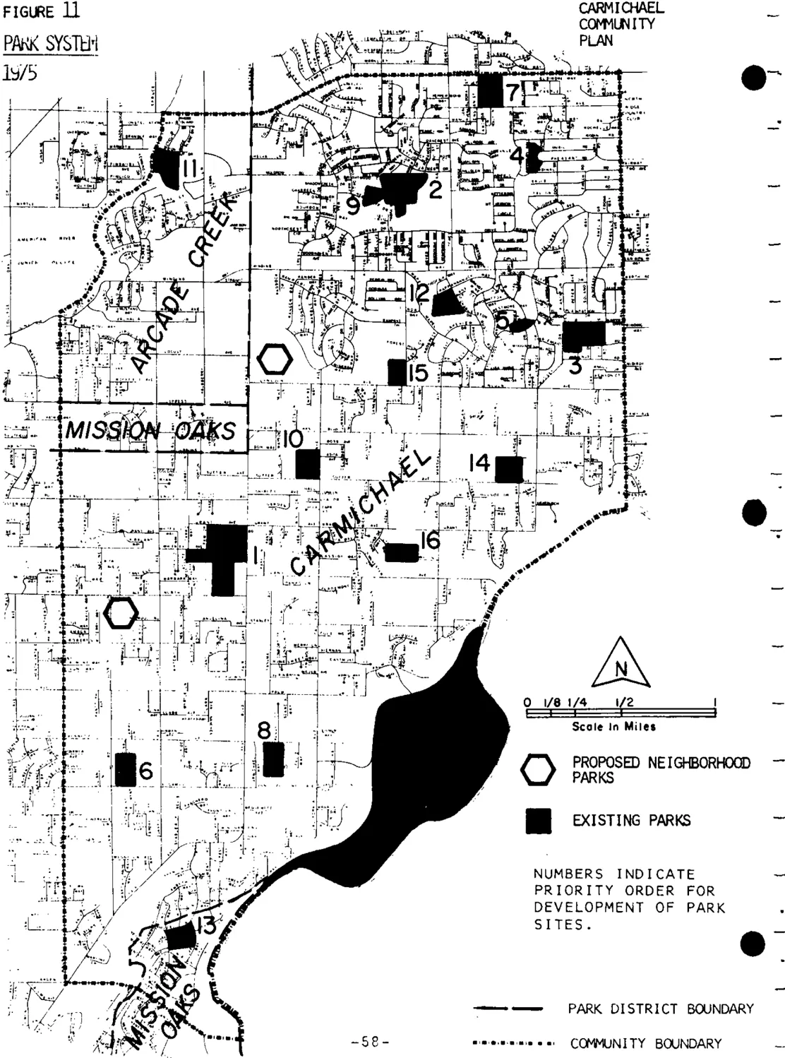
TABLE 10 PARKS IN ORDER OF DEVELOPMENT PRIORITY
Section titled “TABLE 10 PARKS IN ORDER OF DEVELOPMENT PRIORITY”| PRIORITY | SITE | SIZE (ACRES) | TYPE OF PARK | STATUS |
|---|---|---|---|---|
| 1. | CARMICHAEL PARK | 37 | Community | Developed |
| 2. | DEL CAMPO | 24 | Community | Acquired |
| 3. | SCHWEITZER GROVE | 16 | Neighborhood | Acquired |
| 4. | BIRD TRACT | 1 | Mini | Developed |
| 5. | STOLLWOOD | 2 | Mini | Acquired |
| 6. | CARDINAL COURT | 10 | Neighborhood | Acquired |
| 7. | PALM AVENUE | 10 | Neighborhood | Acquired |
| 8. | KENNETH AVENUE | 5 | Neighborhood | Acquired |
| 9. | THOMAS KELLEY SCHOOL | 5 | Joint Development | Acquired |
| 10. | CARMICHAEL SCHOOL | 5 | Joint Development | Acquired |
| 11. | ARCADE CREEK (1) | 7 | Community | Acquired |
| 12. | MAPLE LANE | 10 | Neighborhood | Acquired |
| 13. | SHELFIELD DRIVE (2) | 6 | Neighborhood | Acquired |
| 14. | HOLLISTER | 6 | Neighborhood | Acquired |
| 15. | BARRETT SCHOOL | 10 | Joint Development | Acquired |
| 16. | GRANT AVENUE | 8 | Neighborhood | Acquired |
(1) Within the Arcade Creek Recreation and Park District.
(2) Within the Mission Oaks Park District.
Passive Recreational Open Space
Section titled “Passive Recreational Open Space”Passive recreation areas are those open spaces providing for unorganized activities of limited physical exercise, such as picnicking, walking, quiet relaxation, and talking. Vacant schools and undeveloped park s sites’ make up most of these areas in addition to portion of the American River Parkway and Carmichael Park.
This means that most of the existing passive recreation areas are temporary. To insure the continuation of such areas, all new parks constructed in the community should have some passive recreation areas. Some minimal maintenance and development, if any, would be required for these areas.
The portion of Arcade Creek at the northwestern part of Carmichael is a significant passive recreational area. A bike trail traversing the Creek through Sacramento County is proposed. Adequate access to this trail should be maintained from at least one point in Carmichael. The County of Sacramento will probably be financially responsible for this parkway.
The large grove of oak trees on the east side of Manzanita between Winding Way and Madison Avenue is an outstanding visual point in Carmichael. This community asset should be maintained for public enjoyment, if at all possible. The adopted community land use plan map indicates this site in an RD-1 category.
The orchard behind the library is another passive recreation area. It is owned by the County and should remain in public ownership and be accessible to the public. Should the County develop this area as additional parking for the library, careful attention should be paid to preserving the natural beauty of the area.
FIGURE 12 PASSIVE RECREATIONAL OPEN SPACE, 1974
Section titled “FIGURE 12 PASSIVE RECREATIONAL OPEN SPACE, 1974”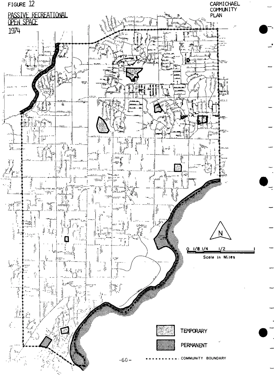
Open Space for the Preservation of Natural Resources
Section titled “Open Space for the Preservation of Natural Resources”In Carmichael the most significant natural resource areas are the natural stream courses, rolling terrain and major tree groves. Unfortunately, must of these original, natural resources have either been channelized or piped, graded and filled, or cut down. It is most important to preserve what is left so that Carmichael does not become one monotonous, unidentifiable suburb of asphalt channels and buildings. Outside the obvious benefit of the aesthetically pleasing impact of such natural areas, the preservation of natural resources provides a necessary balance between man-made and natural elements in an urban area, which helps to prevent a deterioration of the quality of life.
The map on the following page shows those natural resource areas proposed to be preserved. Most of the areas are within the natural drainage basin of Carmichael Creek. This preservation program is directed at prohibiting development within the floodable portion of the drainage areas. It is not meant to provide public access through these areas. Such access would most likely destroy a major portion of what makes these resources valuable.
The Save Our Soil Project near La Sierra High School is included in this section as is the nature area adjacent to Marvin Marshall School. Both sites provide excellent educational opportunities for residents of the areas and should be continued. There are other small creek areas which should remain in their natural states and no public access provided.
FIGURE 13 NATURAL RESOURCES AREAS, 1974
Section titled “FIGURE 13 NATURAL RESOURCES AREAS, 1974”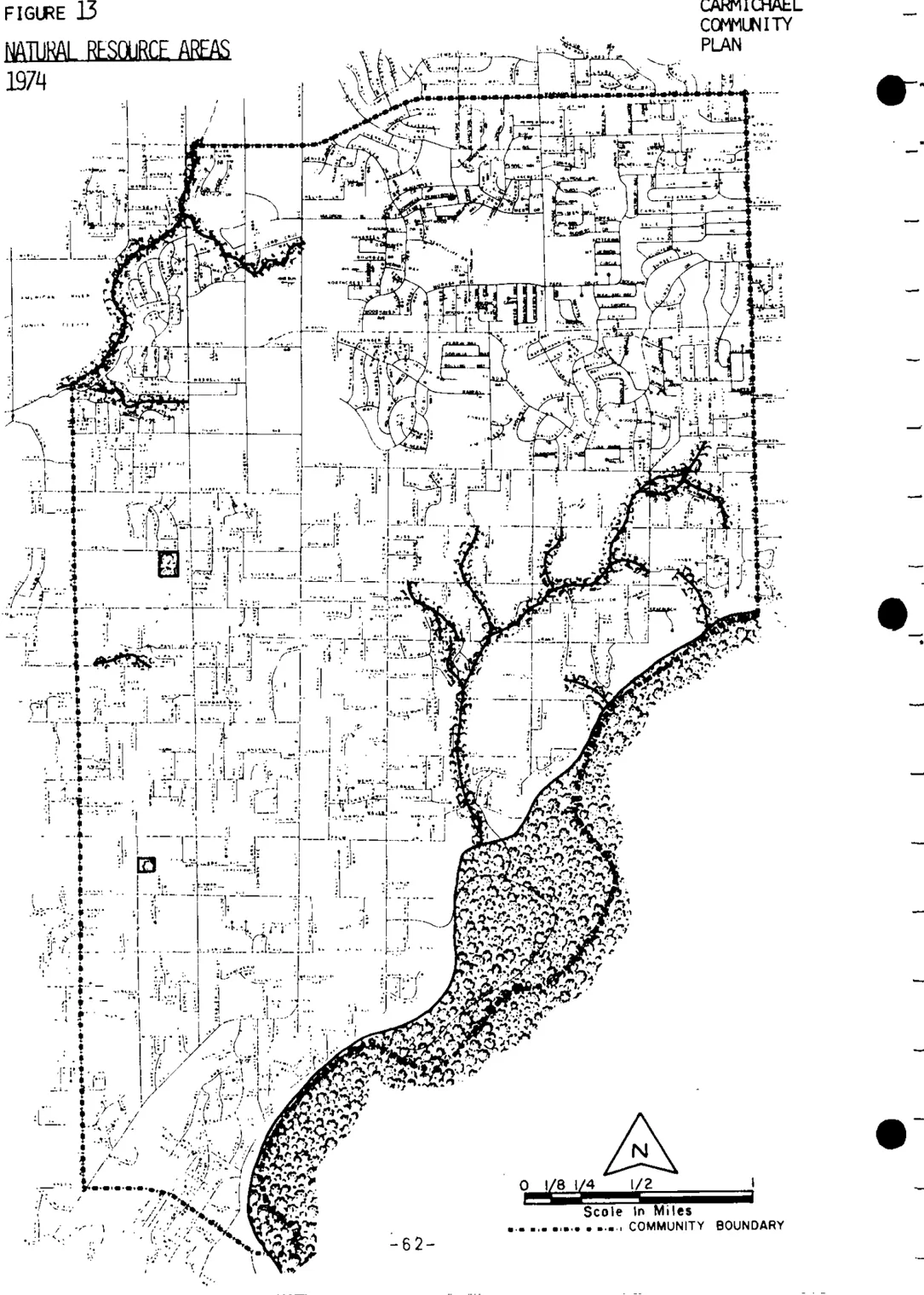
Scenic Corridors
Section titled “Scenic Corridors”The major reason for scenic corridors is to insure the preservation of desirable characteristics which exist along the path of a street or highway. Those desirable characteristics may be outstanding scenic beauty, unique architectural design, points of historical significance, recreation areas or simply uncluttered spots which should remain. The Gold Rush Parkway scenic corridor follows a path from downtown Sacramento, through Carmichael along Fair Oaks Boulevard (See figure 14) and up to the old gold rush country through Folsom, Auburn and Cool. While certain of the areas in Carmichael along the Parkway are something less than scenic, other areas are as beautiful as any spot in Sacramento County. It is desirable to upgrade the substandard areas in the scenic corridor, and insure that new developments exhibit a high quality of design. The Gold Rush Parkway scenic corridor plan has been adopted by the Board of Supervisors and appropriate regulations, controls and design criteria should be instituted to implement the objectives of the corridor. Identification signs for the scenic corridor are proposed. This signing should be carried out by Sacramento County.
Historical Preservation Zones
Section titled “Historical Preservation Zones”The preservation of sites of historical and cultural significance is important if we are to maintain a link between our past experiences and present lives. Without some sense of history, the individual is unable to retain a clear understanding of what has brought him to where he is and what to expect in the future.
Carmichael has a rich history, yet little evidence is left for new residents to see and understand. The most recent action which has contributed to the further disappearance of Carmichael’s history was the demolition of the original Carmichael School, the first school built in Carmichael in 1917.
All sites identified as having historical significance to Carmichael should be retained if it is within the community’s ability to do so. The palm trees along Palm Drive should be preserved as a reminder of the earliest farmers in Carmichael who lived along the road.
A group of local residents should be established to advise the Board of Supervisors as to other sites of historical significance. Those sites should then be incorporated into this community plan as areas to be retained as historical preservation zones.
FIGURE 14 GOLDRUSH PARKWAY SCENIC CORRIDOR, 1974
Section titled “FIGURE 14 GOLDRUSH PARKWAY SCENIC CORRIDOR, 1974”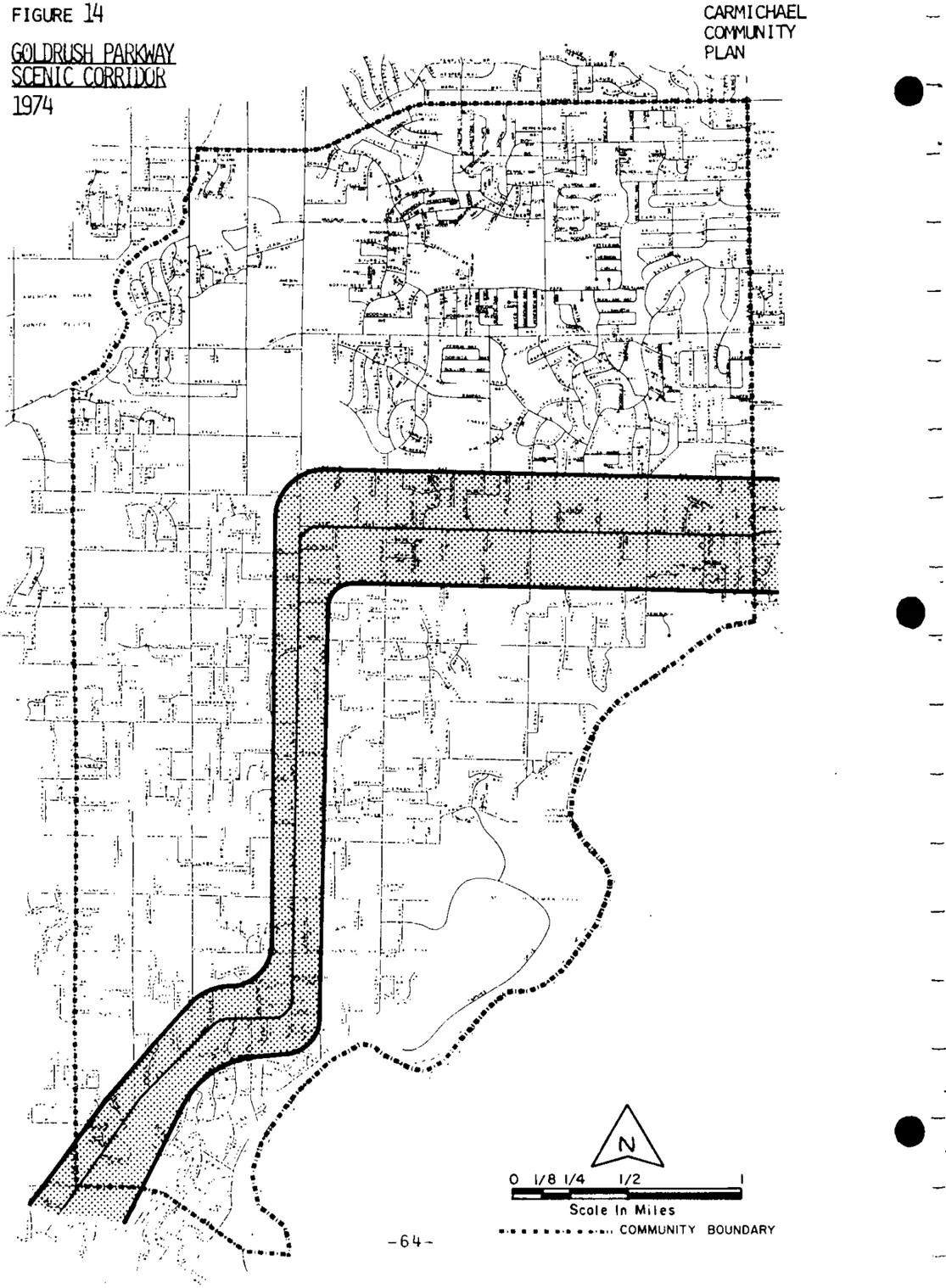
Unique, Semi - Rural Residential Areas
Section titled “Unique, Semi - Rural Residential Areas”Carmichael’s major asset as an attractive community are those portions of its residential areas which are sparsely populated and have substantial areas of private open space. These open areas, with horse pastures, large trees, natural creeks, and rolling terrain make Carmichael unique in Sacramento suburbia. Not only are these areas aesthetically pleasing and environmentally sensitive, the relatively low population density has meant fewer urban problems. Additionally, since this residential pattern has existed for a considerable amount of time, there are numerous older homes in the area which provide housing for lower income families. It is of the greatest importance to insure the continuation of this type of open space in Carmichael .
METHODS OF OPEN SPACE PRESERVATION
Section titled “METHODS OF OPEN SPACE PRESERVATION”There are numerous methods available to insure the preservation of open spaces in Carmichael. They range from outright public acquisition to voluntary programs. Each has its assets and detriments. A program which is ideal for one form of open space preservation might be undesirable for another.
Acquisition of Title in Fee Simple
Section titled “Acquisition of Title in Fee Simple”This is the most costly method, since it usually requires the payment of the full market value of the land. It is also the most effective, since the public agency, as owner, has full control over the use of the land. This is the most effective method of open space preservation in terms of long range planning. The property can be obtained through open market purchase, condemnation, eminent domain, installment purchase, tax delinquency or donation. Donation is the one major form of acquisition of title in fee simple which is not costly to park districts and is always encouraged. Combined with a life estate for the property owner, this form of park acquisition provides an excellent outlet for residents to provide a service to the community. Acquisition of title in fee simple is most useful and generally necessary for active and passive recreational open spaces.
Acquisition of Less than Fee Simple
Section titled “Acquisition of Less than Fee Simple”This method, generally referred to as easements, is less costly than outright acquisition, but is also less effective. Depending upon the type of easement acquired, the cost generally runs from 1/3 to 1/10 of the assessed value of the land. An easement can be positive if it acquires certain rights for the public, or negative if it prohibits the property owner from certain actions. In Carmichael, this method would be most useful in maintaining access to the American River Parkway and preserving the natural resource and historical areas.
FIGURE 15 SEMI-RURAL RESIDENTIAL AREAS, 1974
Section titled “FIGURE 15 SEMI-RURAL RESIDENTIAL AREAS, 1974”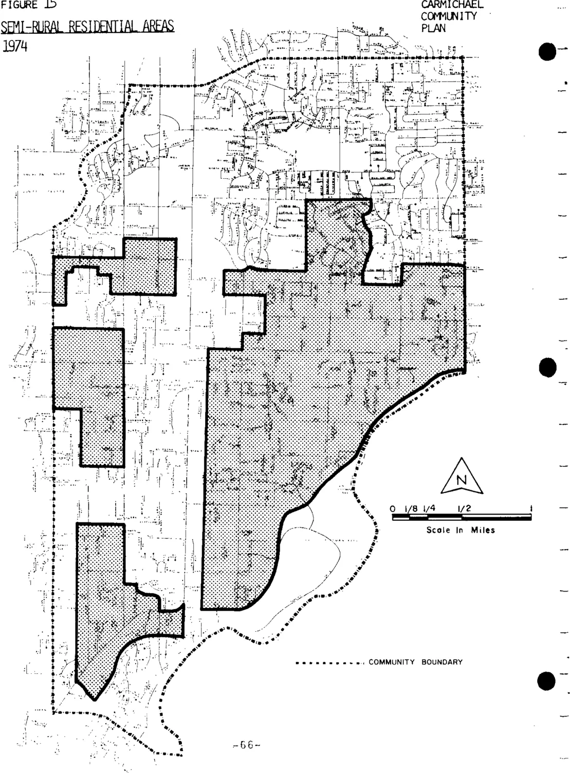
Police Power
Section titled “Police Power”This method is limited in scope and power, but very few costs are incurred at public expense. The powers presently available include zoning regulations, building code restrictions, subdivision laws and land dedication or in-lieu fee requirements for subdividers. Certain specialized zoning powers available but not widely used for open space preservation include planned unit development, cluster zoning, density zoning, floating zones and scenic corridor combining zones. The use of police powers will be most effective in preserving scenic corridors, historical areas, and unique residential areas.
Tax Incentives
Section titled “Tax Incentives”California State law enables local cities and counties to offer tax incentive programs in order to preserve open spaces which have scenic value, add to the amenities of living in adjoining areas, or which should remain rural or in its natural state, etc. While being described as easements, these grants of open space generally take the form of a contractual arrangement whereby an owner of property relinquishes his right to develop his property any further in return for which the City or County assesses the value of his property based upon such restrictions rather than the market value which is based in part on the developable potential of the land. This process is similar to the Williamson Agricultural Preserve assessment program presently carried out by Sacramento County for its rural areas. This would be most useful in preserving, under private ownership and access, the unique, semi-rural residential areas of Carmichael. It is proposed that this type of program be instituted in Sacramento County.
RECOMMENDATIONS
Section titled “RECOMMENDATIONS”Many proposals concerning park and recreation, and open space lands have been outlined in this section. In order for these proposals to be implemented, it is recommended that:
- The responsible park districts acquire and develop the recommended park sites to assure a complete system of community and neighborhood parks within walking distance of every Carmichael resident.
- The County of Sacramento acquire and maintain all public, non-motorized access to the American River Parkway as indicated on the Parkway Plan or as historically used.
- The San Juan Unified School District provide for the use of school recreation facilities after school hours given adequate vandalism protection.
- The County of Sacramento prohibit all development of or within designated, natural stream areas.
- The Carmichael Recreation and Park District and the County of Sacramento should jointly preserve all areas of outstanding scenic beauty in Carmichael through purchase where all other means fail.
- The County of Sacramento adopt the necessary regulations to implement the Gold Rush Parkway Plan scenic corridor concept and programs.
- Further destruction of sites of historical significance be prohibited by the County.
- The preservation of private open spaces be actively encouraged by the County through the adoption of an open space preservation program which allows owners of parcels l acre or larger to, in effect, “sell” further developments rights of their property to the County.
- The County of Sacramento actively encourage the development of cluster developments and other innovative construction techniques which maximize the amount of open space within residential and commercial areas.
PUBLIC FACILITIES AND UTILITIES
Section titled “PUBLIC FACILITIES AND UTILITIES”This section is included in this report in order to give a summary description of those public and quasi-public facilities in Carmichael which provide services essential to the continued functioning of the community. The utilities described here include water, liquid and solid waste disposal, and drainage. Public facilities discussed include schools, the library, police and fire protection, and public agency branch offices.
WATER SUPPLY
Section titled “WATER SUPPLY”While the Carmichael study area is supplied water by five separate water districts, the major agency in the community in terms of area served is the Carmichael Irrigation District (see Fig. 16). 75% of the district’s water supply comes from the American River, with the remaining 25% pumped from 8 wells during the peak summer use periods. The water is of high quality, treated only by small amounts of chlorination. The District has ample capacity to serve all projected population increases in Carmichael, either through increased usage of present facilities or the addition of a Ranney collector under the river at the northern end of Hoffman Park.
The Carmichael Irrigation District and the surrounding districts provide high quality, inexpensive water to the community. In certain cases, it may be desirable for two of the districts to consolidate and for some other minor boundary adjustments. Otherwise, the process of supplying water to Carmichael is well served by the present supplies. The districts should work together to develop permanent ties between their systems in order to provide mutual aid in the event of emergency needs. This type of cooperation will benefit the citizens living in all of the districts affected.
LIQUID WASTE DISPOSAL
Section titled “LIQUID WASTE DISPOSAL”The Northeast County Sanitation District, which serves all of Carmichael, is a dependent district which serves the entire northeastern sector of the County. Sewage is treated at two treatment plants. The largest plant, a secondary level plant with activated sludge and disinfection, is located on Arden Bar. The smaller plant in Fair Oaks is a trickling filter plant with disinfection. This second plant will eventually be abandoned, and the Arden Bar plant will pump its sewage south to the new central sanitation plant to further consolidate the treatment facilities.
The entire study area has been sewered, although there are individuals who have chosen not to hook up to the mains as yet. It is assumed that eventually all liquid disposal in Carmichael will be through the public disposal system.
FIGURE 16 WATER DISTRICTS, 1974
Section titled “FIGURE 16 WATER DISTRICTS, 1974”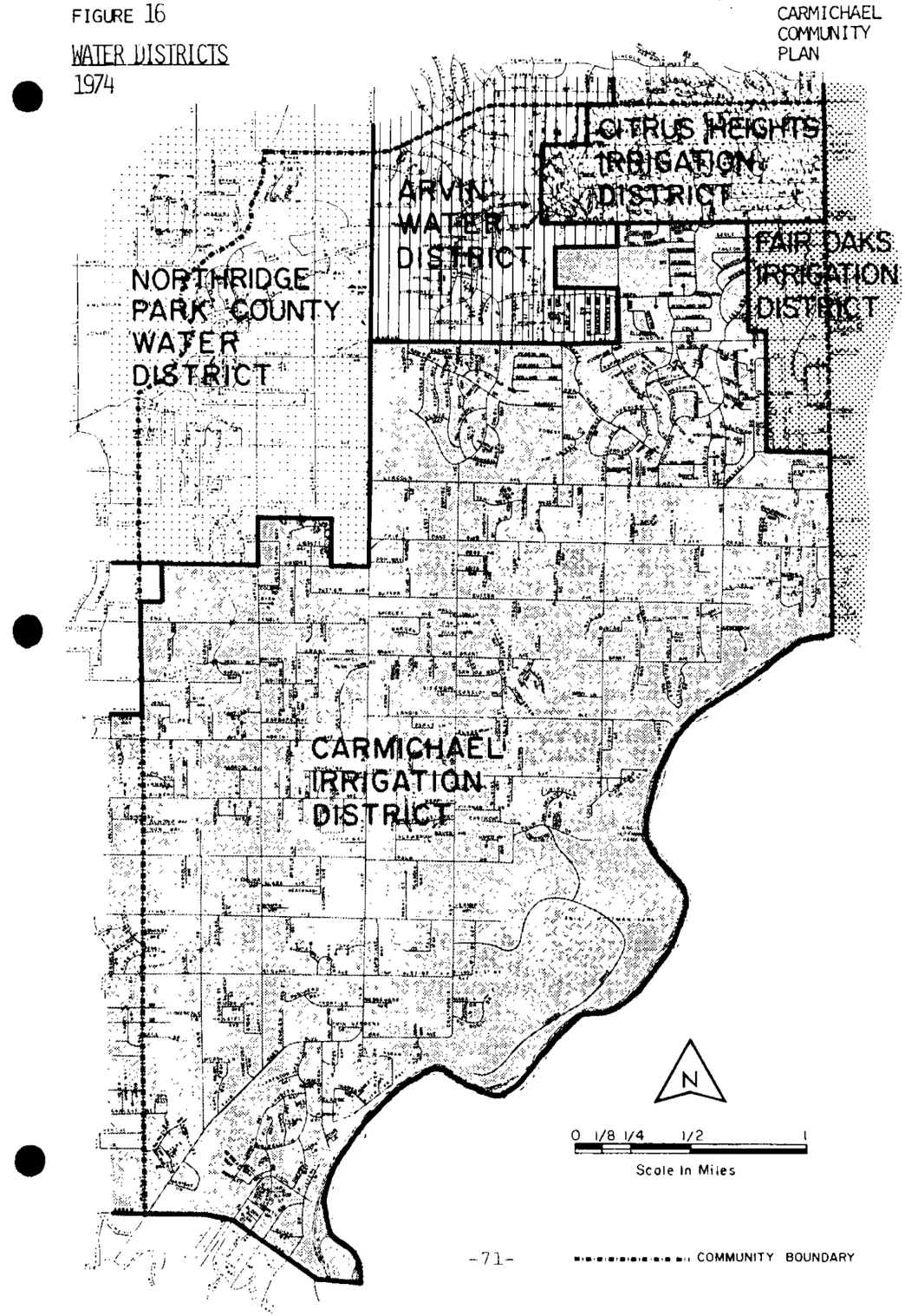
SOLID WASTE DISPOSAL
Section titled “SOLID WASTE DISPOSAL”Solid waste disposal in Carmichael is operated by Sacramento County. The sanitary land fill disposal system is financed by user’s fees. The County now operates sites at Gerber and Excelsior Roads and at Kiefer Boulevard and Grant Line Road.
DRAINAGE
Section titled “DRAINAGE”The provision for and maintenance of adequate drainage facilities in Carmichael is a two step procedure. The County Public Works Department is responsible for the provision of drainage facilities. Carmichael is in Zone 11 and all Carmichael residents pay a certain portion of their property taxes to the County to provide a drainage system. The Metropolitan Storm Drain Maintenance District is a dependent, special district whose directors are the Board of Supervisors. This district has responsibility for maintaining all drainage facilities within its area of jurisdiction. A portion of Carmichael, south and east of Fair Oaks Boulevard, is not included in this district, since those residents have rejected annexation. Consequently, individual resident property owners are responsible for maintaining the drainage system, man-made or natural, where it crosses their property. They are also liable for any damage their lack of drainage maintenance causes
SCHOOLS
Section titled “SCHOOLS”The Carmichael Study Area lies fully within the San Juan Unified School District. The 12 elementary (K-6), 4 junior high (7-8) and 3 senior high (9-12) schools serving the area are listed on Table 11. Figure 17 illustrates the location of the various schools, including the 4 vacant school sites in Carmichael. Some of the schools lie outside the study area and some students outside the study area attend schools in Carmichael. This situation is inevitable when boundaries for differing purposes are drawn in the same area. Generally though, the 19 schools listed serve Carmichael. There are approximately 12,000 school age children living in the Carmichael study area, and 15,000 students enrolled in the 19 schools.
FIGURE 17 SCHOOL SITES, 1974
Section titled “FIGURE 17 SCHOOL SITES, 1974”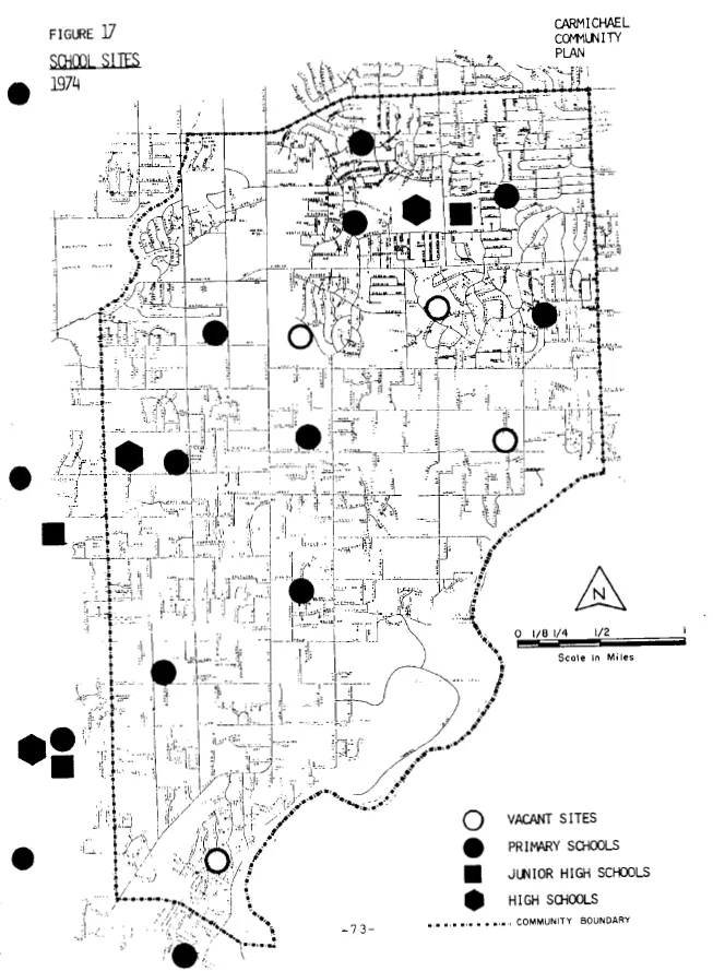
TABLE 11 EXISTING SCHOOLS by Capacity & Enrollment
Section titled “TABLE 11 EXISTING SCHOOLS by Capacity & Enrollment”| SCHOOL | CAPACITY | SEPTEMBER, 1973 ENROLLMENT | % OF CAPACITY |
|---|---|---|---|
| K - 6 | |||
| CAMERON RANCH | 544 | 460 | 85 |
| CARMICHAEL | 854 | 510 | 60 |
| DEL DAYO | 606 | 545 | 90 |
| DETERDING | 665 | 568 | 85 |
| DEWEY | 978 | 785 | 80 |
| GARFIELD | 663 | 440 | 66 |
| THOMAS KELLY | 551 | 565 | 103 |
| MARSHALL | 639 | 443 | 69 |
| PECK | 792 | 593 | 75 |
| SCHWEITZER | 577 | 509 | 88 |
| STARR KING | 437 | 287 | 65 |
| SUB-TOTAL | 7,306 | 5,695 | 78 |
| 7 & 8 | |||
| BARRETT | 856 | 776 | 91 |
| CHURCHILL | 808 | 842 | 104 |
| ROGERS | 1,100 | 1,196 | 109 |
| STARR KING | 580 | 640 | 110 |
| SUB-TOTAL | 3,344 | 3,476 | 104 |
| 9 - 12 | |||
| DEL CAMPO | 1,992 | 2,330 | 117 |
| EL CAMINO | 2.113 | 1,609 | 76 |
| LA SIERRA | 1,992 | 2,017 | 103 |
| SUB-TOTAL | 6,060 | 5,956 | 98 |
| TOTAL | 16,728 | 15,126 | 90 |
Source: San Juan Unified School District
Note: Portions of this table were illegible in the original document which resulted in potential inaccuracies in the data captured during the remediation of the table above. For accurate data please contact San Juan Unified School District.
TABLE 12 SCHOOL POPULATION AS IT RELATES TO STAGES OF COMMUNITY DEVELOPMENT
Section titled “TABLE 12 SCHOOL POPULATION AS IT RELATES TO STAGES OF COMMUNITY DEVELOPMENT”| YEAR | STATUS OF POPULATION DEVELOPMENT (%) | TOTAL POPULATION (1,000’s) | K-12 POP. AS PERCENT OF TOTAL POP. | ESTIMATED K-12 POPULATION |
|---|---|---|---|---|
| 1970 | 66.6 | 37.5 | 31 | 11,625 |
| 1990 | 90 | 53-58 | 27 | 14,310-15,660 |
| ULTIMATE | 100 | 57.5-64 | 24 | 13,800-15,360 |
Source: Sacramento County Planning Department.
The Carmichael Community Plan proposes no new schools to be developed in the study area. Referring to Table 6, Carmichael is already two-thirds developed population wise. It has been shown that as a given area develops, the school-age portion of the population declines. It is expected that in Carmichael, the school population will rise for a time and then drop somewhat and level off. Since the schools are presently at 90% capacity, there is room for an additional 1500 students. The total student population will be more than 16,700 at its peak, but not enough more to justify additional school sites in Carmichael. Mesa Verde High School, constructed in Citrus Heights is a regional high school, drawing students from throughout the San Juan District. This will relieve pressures due to overcrowding in Del Campo and La Sierra High Schools. Since El Camino is functioning at only 75% capacity, additional student loads can be shifted there if needed.
Junior high schools seem to represent the only significant overcrowding problem in the study area. Barrett is the only one of four not over capacity at this time. Since the portion of junior high students in the school age population generally remains constant, the overcrowding of facilities may become a temporary problem. Over the long run, the problem will subside. Therefore, no new junior high school sites are recommended to be developed. If needed, facilities should be expanded on existing sites. These facilities should either be temporary buildings or permanent buildings which can be converted from classrooms to community-oriented uses when the requirements for classroom space diminish.
The elementary schools are at only 80% capacity now. From all indications, the existing facilities offer more than enough space to fulfill the future classroom needs. The only apparent problem neighborhood is in the northwest section of the study area. A 100% increase in population is projected at ultimate development in that area. The school attendance boundaries are already gerrymandered to compensate for the closure of Hemlock School, on Hemlock Avenue north of Madison. Should the population expand in this area as anticipated, Hemlock School may have to be reopened to accommodate the future students. Therefore, Hemlock School should be retained for possible reopening should the need occur.
LIBRARY
Section titled “LIBRARY”There are presently 30 libraries in the Sacramento County Library system. The Carmichael branch, on Marconi Avenue west of Fair Oaks Boulevard is one of two regional libraries. It serves a large population in the northeast portion of Sacramento County. It is probably the finest library in the County system. It will undoubtedly expand in the future,* should the user demand continue to increase. As a regional library, it is expected to serve 100,000-175,000 people with 200,000-350,000 books, 300 periodical titles, and specialized material not generally found in the smaller community libraries. No additional branch is needed in the Carmichael area.
*Sunday opening is being tried on an experimental basis now.
FIRE PROTECTION
Section titled “FIRE PROTECTION”The Carmichael Community Study area is almost entirely within the Carmichael Fire District. Fifty-three paid personnel and 12 volunteers operate the district’s three fire stations, two of which are in the study area. The fire protection service is of high quality and the existing stations provide adequate fire protection coverage for the future. Increased service requirements due to population increase will be met with the replacement and addition of necessary equipment and personnel.
LAW ENFORCEMENT
Section titled “LAW ENFORCEMENT”Police protection in Carmichael is provided by the Sacramento County Sheriff’s Department and the California Highway Patrol. The Sheriff’s Department is a relatively well-manned (1.5 sworn personnel per 1,000 population), innovative organization which has attempted to provide good police protection in Carmichael. An example of this is the horse patrol of Ancil Hoffman Park during the summer. New methods and equipment are regularly tested to improve public service and protection.
PUBLIC AGENCIES
Section titled “PUBLIC AGENCIES”A few county and state branch offices are presently located in Carmichael. Their locations are temporary and scattered throughout the community. While these existing branches are small and limited in scope, the possibility exists that additional larger agencies may locate in Carmichael. In view of the fact that fully l/3 of the work force in the County is employed by public agencies, and that 70% of Carmichael’s work force is white collar, the opportunity for decentralized public agencies to locate in Carmichael is great. Also, in view of the increasing economic and social costs of our transportation system, it is desirable for major employers (state and county offices) to locate new buildings in the suburban areas. To plan for and encourage this trend, it is recommended that any new public offices to be located in Carmichael be placed in the business and professional district along Fair Oaks Boulevard near Carmichael Park. This is a centralized, well serviced area which has the strongest identity as the community center of any location in Carmichael. Well located and designed public buildings in this area would improve and enhance the whole central area of Carmichael.
FIGURE 18 FIRE DISTRICTS, 1974
Section titled “FIGURE 18 FIRE DISTRICTS, 1974”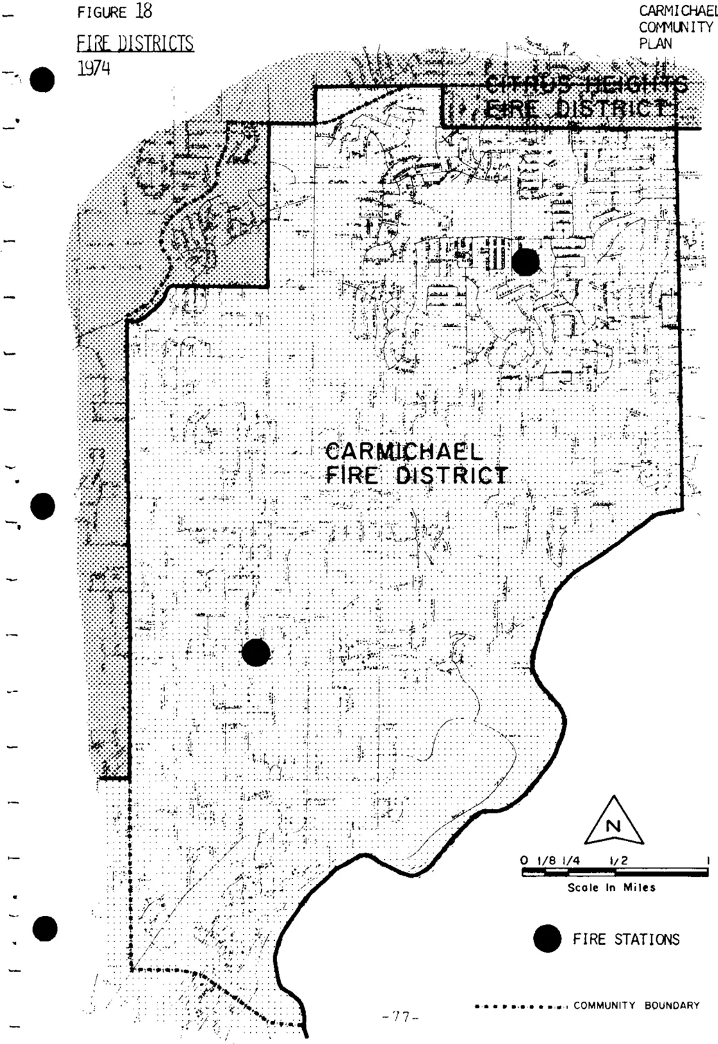
IMPLEMENTATION
Section titled “IMPLEMENTATION”GOAL: TO WORK FOR FULL IMPLEMENTATION OF ALL RECOMMENDATIONS PRESENTED IN THIS COMMUNITY PLAN.
Implementation is the key to the success of any plan. A land use plan such as this is really only a beginning point. It outlines the problems which exist, poses some possible solutions and points the way toward achieving a better community. Once that way is pointed, it is up to the community and their representatives to make the whole thing work. All the lofty ideals and grand plans are not worth the paper they are printed on if they are not implemented. It is in this context that this last chapter of the Carmichael Community Plan is written.
There are several vehicles by which this plan will be implemented. They include: new policies, which the Planning Commission and the Board of Supervisors should adopt and follow in their’ daily decision-making processes; specific actions in the term of new or revised ordinances and new committees; capital expenditure programs; and zoning consistency.
POLICIES
Section titled “POLICIES”Throughout this document are numerous recommendations which, if adopted, need to be stated as formal policy of the Planning Commission and Board of Supervisors relative to planning matters in Carmichael. Many of these recommendations have become de facto policy over the course of the past few years while no real policy exists concerning others. Those policy changes recommended are listed below. It is recommended that it become official policy of the County of Sacramento to:
- Encourage all public and private development in the commercial center of Carmichael to emphasize its character as a public gathering place and community center through proper architectural and environmental design;
- locate any new County facilities planned for the Carmichael area in the community center;
- discourage strip commercial development;
- encourage creative, progressive development throughout Carmichael;
- preserve to the greatest extent possible those semi-rural areas which exemplify that residential character of Carmichael;
- insure that new, higher density residential development is compatible with the surrounding area and is adequately served by transportation and recreation facilities;
- encourage innovative, progressive methods of solving the transportation problems of Sacramento County;
- encourage the development of pathways for non-motorized modes of transportation on all new major streets;
- support the efforts of the Regional Transit District to provide expanded bus service in Carmichael;
- support the Carmichael Recreation and Park District in its efforts to provide a thorough system of parks in Carmichael;
- maintain an open, accessible American River Parkway:
- prohibit any further development or “improvement” of the natural streams in Carmichael;
- prohibit the further destruction of any sites of historical significance in Carmichael; and
- encourage the use of innovative construction techniques which maximize usable open space in new residential and commercial development.
ACTIONS
Section titled “ACTIONS”Certain recommendations in this plan propose that the County of Sacramento undertake specific actions. The actions which are listed below are recommended by both Alternatives I and II and the adoption of the plan so that any new directions the County takes as a result of the plan will be current, viable, and understood by all. It is recommended that the County of Sacramento:
- Adopt a design review ordinance;
- adopt a strict, progressive sign ordinance;
- provide a design plan for the commercial center of Carmichael;
- create a community-based planning review council;
- hold zoning consistency hearings to bring existing z zoning of property into conformance with the proposals of the adopted plan;
- amend the R-l-B zoning district so as to prohibit development incompatible with the intent of the zone which is to allow for a variety of low density and semi-agricultural uses in the same general area.
- amend the R-E-3 and R-E-2 zoning districts so as to allow the boarding of horses;
- adopt and implement the Gold Rush Parkway Plan Program;
- adopt a comprehensive noise ordinance;
- adopt an expanded open space preservation program which will preserve small private open spaces in the urban areas of the County;
- Change the standard County land use designations to more accurately describe the type and density of land uses;
- delete State Freeway Routes 143 and 244 from the Sacramento County streets and highways system in favor of alternative transportation modes;
- install class “A” street improvements on those portions of Walnut, Garfield, San Juan, Marconi, El Camino, and Manzanita Avenues, and Fair Oaks Boulevard, Dewey Drive, and Engle Road not presently developed to class “A” standards; and
- allow the orderly completion of Jan Drive with the understanding that it not become a major arterial through a residential area.
Certain special districts are also recommended to take specific follow-up actions.
The Regional Transit District is encouraged to continue to improve mass transit services in Carmichael by:
- Decreasing headways and increasing the number of routes and hours of operations as detailed in the text;
- investigating the possibility of providing dial-a-bus service in Carmichael; and
- working closely with citizens’ groups such as the CCAC in order to meet the transit needs of the community.
The Carmichael, Mission Oaks and Arcade Creek Recreation and Park Districts are encouraged to:
- Acquire and develop those park sites recommended in this plan;
- preserve sites of outstanding scenic beauty in their natural state wherever possible; and
- work closely with the CCAC and other citizens’ groups who are interested in preserving parks and open space in Carmichael.
The San Juan Unified School District is urged to:
- Allow all school recreation facilities to be used after school hours, given adequate protection against vandalism; and
- hold surplus school sites for the appropriate park districts until such time as those districts are able to purchase them.
CAPITAL EXPENDITURES
Section titled “CAPITAL EXPENDITURES”Two sections of this plan contain recommendations which require capital expenditures if they are to be implemented. Those recommendations relate to street improvements and open space acquisition. Both of these categories of expenditures are essential to the development of a positive, attractive community, and should be given considerable attention. It is therefore recommended that capital improvement programs be developed for these categories of expenditures, including a priority listing of all proposed projects, projected costs, and time of development. These capital improvement programs should be reviewed with the community advisory council annually to insure that they reflect the most current attitudes of the community.
Carmichael Recreation and Parks District, Arcade Creek recreational and Park District and Mission Oaks Park District should prepare capital improvements programs for acquisition and development of parks that is consistent with the priorities set forth in this Plan.
ZONING CONSISTENCY
Section titled “ZONING CONSISTENCY”Following the final adoption of this plan, the County Zoning District Maps should be amended to bring them in general conformity with the land use plan. While the land use plan determines general residential densities and the relationship between land uses in Carmichael, zoning is necessary to express in detail permitted uses, building size and location, minimum lot areas and so forth. These two elements, land use and zoning, are the major planning tools now used in Sacramento County, with land use representing an expression of policy and zoning the implementation of that policy.
The zoning consistency matrix on the next page indicates those zones that are consistent with various land use categories. Sometimes a zone will allow a slightly higher density than the land use category it is consistent with. This is due to the lack of exact fit between the definitions of zones and the definitions of land use categories. The lack of fit presents more problems on paper than it does in real life, since actual densities usually average below the maximum permitted by zoning.
Hearings will be held after adoption of this plan to rezone those areas of Carmichael which are not now zoned consistently with the Plan. The matrix will be used to determine the necessary rezoning. In certain circumstances, departures will be made from matrix to recognize existing uses or peculiarities of parcels. For instance, in the case that the matrix would require a rezone that would render a parcel or use nonconforming to the Zoning Code and that use or parcel was created prior to adoption of the Plan, there may be a departure from the matrix. However, generally, it is the intention of the plan that all rezoning in the Carmichael area be consistent with the Plan.
Of particular concern to a number of Carmichael residents is the A-1-A zone as it relates to the continuation of incidental agricultural uses in residential areas. While generally considered a transition zone between agricultural and residential land uses, it is not the intention of this plan to eliminate those areas by changing the zoning classifications. On the contrary, a major emphasis of the plan is to enable individuals to retain incidental agricultural uses. The A-1-A zone is considered consistent with most proposed land use designations.
To comply with accessibility requirements, Table 19 has been split into Tables 19A-F.
Key for all tables below:
C - Consistent
N - Not Consistent
Table 19A ZONING CONSISTENCY MATRIX - AGRICULTURAL HOLDING AND GENERAL AGRICULTURAL ZONES
Section titled “Table 19A ZONING CONSISTENCY MATRIX - AGRICULTURAL HOLDING AND GENERAL AGRICULTURAL ZONES”| Agricultural Holding and General Agricultural Zones | Parkways | Parks | Public and Quasi Public | Business and Professional | Other Retail Commercial | Shopping Center Commercial | General Commercial | Residential Density 40 (RD-40) | Residential Density 20 (RD-20) | Residential Density 10 (RD-10) | Residential Density 5 (RD-5) | Residential Density 2 (RD-2) | Residential Density 1 (RD-1) |
|---|---|---|---|---|---|---|---|---|---|---|---|---|---|
| A-10 | C | C | C | N | N | N | N | N | N | C | C | C | C |
| A-2-A | C | N | C | C | C | C | C | C | C | C | C | C | C |
| A-2-B | C | N | C | N | N | N | N | N | N | N | N | N | C |
| A- | C | N | C | C | C | C | C | C | C | C | C | C | C |
| A-1-B | C | N | C | N | N | N | N | N | N | N | N | N | C |
| A-1-A | C | N | C | C | C | C | C | C | C | C | C | C | N |
Table 19B ZONING CONSISTENCY MATRIX - RECREATION ZONES
Section titled “Table 19B ZONING CONSISTENCY MATRIX - RECREATION ZONES”| Recreation Zones | Parkways | Parks | Public and Quasi Public | Business and Professional | Other Retail Commercial | Shopping Center Commercial | General Commercial | Residential Density 40 (RD-40) | Residential Density 20 (RD-20) | Residential Density 10 (RD-10) | Residential Density 5 (RD-5) | Residential Density 2 (RD-2) | Residential Density 1 (RD-1) |
|---|---|---|---|---|---|---|---|---|---|---|---|---|---|
| O - Recreation | C | C | C | C | C | C | C | C | C | C | C | C | C |
| CO - Commercial Recreation | C | C | C | N | C | C | C | N | N | N | N | N | N |
Table 19C ZONING CONSISTENCY MATRIX - ESTATE ZONES
Section titled “Table 19C ZONING CONSISTENCY MATRIX - ESTATE ZONES”| Estate Zones | Parkways | Parks | Public and Quasi Public | Business and Professional | Other Retail Commercial | Shopping Center Commercial | General Commercial | Residential Density 40 (RD-40) | Residential Density 20 (RD-20) | Residential Density 10 (RD-10) | Residential Density 5 (RD-5) | Residential Density 2 (RD-2) | Residential Density 1 (RD-1) |
|---|---|---|---|---|---|---|---|---|---|---|---|---|---|
| RE-5 Estate | N | N | C | N | N | N | N | N | N | C | C | C | C |
| RE-2 Estate | N | N | C | N | N | N | N | N | N | C | C | C | N |
| RE-1 Estate | N | N | C | N | N | N | N | N | N | C | C | N | N |
Table 19D ZONING CONSISTENCY MATRIX - RESIDENTIAL ZONES
Section titled “Table 19D ZONING CONSISTENCY MATRIX - RESIDENTIAL ZONES”| Residential Zones | Parkways | Parks | Public and Quasi Public | Business and Professional | Other Retail Commercial | Shopping Center Commercial | General Commercial | Residential Density 40 (RD-40) | Residential Density 20 (RD-20) | Residential Density 10 (RD-10) | Residential Density 5 (RD-5) | Residential Density 2 (RD-2) | Residential Density 1 (RD-1) |
|---|---|---|---|---|---|---|---|---|---|---|---|---|---|
| R-1-A Single Family | 1 | N | C | C | C | C | C | C | C | C | C | N | N |
| R-1-B Single Family and Duplex | 1 | N | C | C | C | C | C | C | C | C | C | N | N |
| R-2 Two Family | 1 | N | C | C | C | C | C | C | C | C | N | N | N |
| R-2A Two Family | 1 | N | C | C | C | C | C | C | C | N | N | N | N |
| R-10 Multiple Family | 1 | N | C | C | C | C | C | C | C | N | N | N | N |
| RM-1 Mobilehome Park | 1 | N | C | C | C | C | C | C | C | C | N | N | N |
| RM-2 Mobilehome Subdivision | 1 | N | C | C | C | C | C | C | C | C | C | N | N |
| R-TH Residential Townhouse | 1 | N | C | C | C | C | C | C | C | C | N | N | N |
NOTES: 1. PARKWAYS ARE CURRENTLY UNDER STUDY TO DETERMINE CONSISTENT ZONING. IN THE INTERIM RESIDENTIAL ZONES ARE CONSISTENT.
Table 19E ZONING CONSISTENCY MATRIX - COMMERCIAL ZONES
Section titled “Table 19E ZONING CONSISTENCY MATRIX - COMMERCIAL ZONES”| Commercial Zones | Parkways | Parks | Public and Quasi Public | Business and Professional | Other Retail Commercial | Shopping Center Commercial | General Commercial | Residential Density 40 (RD-40) | Residential Density 20 (RD-20) | Residential Density 10 (RD-10) | Residential Density 5 (RD-5) | Residential Density 2 (RD-2) | Residential Density 1 (RD-1) |
|---|---|---|---|---|---|---|---|---|---|---|---|---|---|
| BP - Business & Professional | N | N | C | C | C | C | C | N | N | N | N | N | N |
| CC - Convenience Center | N | N | C | C | C | C | C | C | C | C | C | C | C |
| SC - Shopping Center | N | N | C | N | C | C | C | N | N | N | N | N | N |
| LC - Limited Commercial | N | N | C | N | C | C | C | N | N | N | N | N | N |
| GC - General Commercial | N | N | C | N | N | N | C | N | N | N | N | N | N |
| AC - Auto Commercial | N | N | C | N | C | N | C | N | N | N | N | N | N |
| TC - Highway Travel Commercial | N | N | N | N | C | N | C | N | N | N | N | N | N |
Table 19F ZONING CONSISTENCY MATRIX - COMBINING ZONES
Section titled “Table 19F ZONING CONSISTENCY MATRIX - COMBINING ZONES”| Combining Zones | Parkways | Parks | Public and Quasi Public | Business and Professional | Other Retail Commercial | Shopping Center Commercial | General Commercial | Residential Density 40 (RD-40) | Residential Density 20 (RD-20) | Residential Density 10 (RD-10) | Residential Density 5 (RD-5) | Residential Density 2 (RD-2) | Residential Density 1 (RD-1) |
|---|---|---|---|---|---|---|---|---|---|---|---|---|---|
| Flood Combining | C | C | C | C | C | C | C | C | C | C | C | C | C |
| Planned Development | C | C | C | C | C | C | C | C | C | C | C | C | C |