

Riverwood PD
Sacramento County Zoning Code
Riverwood Planned Development Ordinance
Section titled “Sacramento County Zoning Code Riverwood Planned Development Ordinance”Adopted October 15, 1969
Amended October 5, 1977 & July 26, 1979
69-PD-2
Amended by 69-PD-2A & 69-PD-2B
BASE PLANNED DEVELOPMENT ORDINANCE
Section titled “BASE PLANNED DEVELOPMENT ORDINANCE”SECTION 1.
Section titled “SECTION 1.”Exhibits “B”, “C”, “D”, “E”, “F”, “G”, “H” and “I” attached hereto are incorporated into and made a part of this Ordinance for all purposes. The exhibits are on file in the Office of the Clerk of the Board of Supervisors and are part of this Ordinance as if fully set forth herein.
SECTION 2.
Section titled “SECTION 2.”Section 2 of Ordinance No. 534, as amended, is hereby amended to change the Zoning Classification of the real property described in Exhibit “A” attached hereto from “R-1B” Single Family and Duplex and “F” Flood to “R-1B (PD)” Single Family and Duplex (Planned Development) and “F (PD)” Flood (Planned Development) subject to the provisions of this Ordinance.
SECTION 3.
Section titled “SECTION 3.”During the public hearing on this Ordinance the Board of Supervisors made the following findings:
- That the proposed development will carry out the intent of the General Plan.
- That the proposed development is of sufficient size and is designed so as to provide a desirable environment within its own boundaries.
- That the proposed development is compatible with existing and proposed land uses in the surrounding area.
- That exceptions to the standard requirements of the Basic Zoning Ordinance are justified by the design of the development.
- That the arrangement of dwellings and mixing of dwelling types is justified by larger and more usable open spaces.
- That there is adequate assurance that all public improvements will be installed at the scheduled times as required by the Public Works Department.
- That there is adequate assurance that the development schedule will be met.
- That the existing or proposed utility services are adequate for the uses and population densities proposed.
SECTION 4.
Section titled “SECTION 4.”Property described in Exhibit “A” shall be used only as follows:
- The individual lots in phase 1 (Riverwood Unit No. 1) and subsequent phases shall be limited to single family residential uses and incidental and subordinate accessory uses related thereto.
- The common area in phase 1 (Riverwood Unit No. 1) and subsequent phases shall be limited to the private use for recreation and similar uses by the owners, residents and guests of the single family residential lots.
- Developers and property owners may establish and maintain appropriate storage yards and storage buildings for the maintenance and retention of materials and equipment required for planting, building, repair and maintenance and preservation of structures, gardens and other improvements of the residential lots and common areas.
SECTION 5.
Section titled “SECTION 5.”The uses of the property described in Exhibit “A” shall, in addition to the limitations imposed thereon by Section 4 of this Ordinance, be limited to the uses set forth in the Conditions, Covenants and Restrictions developed for Riverwood Unit No. 1 and subsequent phases of the project. Any change in use during the period the conditions, covenants and restrictions remain in force require a two-thirds (2/3) vote of the membership of the Association and approval of the County of Sacramento.
SECTION 6.
Section titled “SECTION 6.”The Board of Supervisors authorizes the developer(s) of the property to design each dwelling unit or dwelling group in advance of dividing the property into lots. This will permit the developer(s) to locate the dwellings in an esthetic manner and not interfere with the natural beauty of the property. The developer(s) will, as authorized in Section 7, from time to time file subdivision (or other approved forms of maps) to record the actual location of dwellings and the other facilities mentioned above.
SECTION 7.
Section titled “SECTION 7.”In addition to the provisions above the developer(s) shall:
- Record a Subdivision Map for the subject property amending the same as lots are created or alternatively record separate subdivision maps for the several phases of the entire project.
- At the time of filing subdivision maps submit to the Planning Commission for review, sketches or renderings of the typical structures to be erected. The sketches shall show the architectural character and elevation of the structures. The Planning Commission shall approve the proposed developments if it finds that the structures will harmonize and be substantially the same in character and quality as the original structures developed as part of the project.
- Grant the County a deed for ten (10) feet of right of way widening on Oak Avenue including the approximately 100 feet of frontage of the portion of the ownership of Assessors Parcel No. 283-300-39 not included in this application.
- Install street improvements on Oak Avenue including the full frontage of parcel 283-300-39 to the satisfaction of the Public Works Department.
- Provide public access on average of fifteen (15') feet limited to pedestrian, equestrian and non-motorized vehicle traffic across the subject property within the cross-hatched area as shown on Exhibit "I". The access is to connect with public access across the property East of the subject property linking Oak Avenue with Hoffman Park. County shall fence and police the access closing the same to the public when Hoffman Park is closed. This provision shall be of no force and effect after two years from the date of the adoption of this Ordinance unless prior to such date County establishes that within five years from such date that public access will be available across the property to the East to connect Hoffman Park with Oak Avenue.
- Provide for a pedestrian walkway to connect with an anticipated pedestrian walkway across property West of the subject property linking the pedestrian walkway network with River Oak Way - Sarah Court. Owner to locate the walkway at the time of submitting the final subdivision map for the initial phase of the development.
- Provide drainage easements and install drainage facilities to the satisfaction of the Public Works Department including any fee required by Ordinance 1 of the County Water Agency.
SECTION 8.
Section titled “SECTION 8.”[AMENDED 10-05-1977]
No structure shall be located within:
- Twenty-five (25) feet of the East property line;
- Twenty-five (25) feet of the public street right-of-way line of Oak Avenue;
- Twenty-five (25) feet of the bluff line described on Exhibit "C", provided, however, that with regard to lot 50 of said Riverwood Development, a pool or spa may be constructed, notwithstanding any conditions of approval of development plans previously approved, within the twenty-five (25) foot restricted area in a manner substantially as provided on exhibits prepared for Dr. Paul Kelly, approved by the Board of Supervisors August 24, 1977. Said exhibits identified as D-1 and D-2 are incorporated herein as part of this ordinance.
- Ten (10) feet of the west property line excepting the existing house in the southwest corner of the subject property;
- No building, including carport and garage structure, etc., shall be located within ten (10) feet of the right-of-way for the private streets nor in any position which would reduce normal sight distance for vehicles on the street curves and at the intersections with the driveways.
SECTION 9.
Section titled “SECTION 9.”The cross section of the roadways within the project area shall meet County standards as to type and depth of materials, strength of construction, etc., except the width of the roadway may be as specified on the plan.
SECTION 10.
Section titled “SECTION 10.”The covenants, conditions and restrictions, articles of association and incorporation, by-laws, regulations for the maintenance, operation and use of all of the common and jointly owned areas must be approved by the County Counsel’s office before any building permits are issued.
SECTION 11.
Section titled “SECTION 11.”The total number of dwelling units shall not exceed ninety (90). There shall not be more than six (6) dwelling units in any building group.
SECTION 12.
Section titled “SECTION 12.”The variance provision of Section 21 of said Ordinance No. 534, as amended, shall not apply to this Ordinance.
SECTION 13.
Section titled “SECTION 13.”Violation of the provisions of this Ordinance or Exhibits made part of this Ordinance shall be deemed a violation of the Basic Zoning Ordinance, Ordinance No. 534, as amended.
SECTION 14.
Section titled “SECTION 14.”This Ordinance shall take effect and be in full force on and after thirty (30) days from the date of its passage hereof, and before the expiration of fifteen (15) days from the date of its passage it shall be published once with the names of the members of the Board of Supervisors voting for and against the same, said publication to be made in a newspaper of general circulation published in the County of Sacramento.
PASSED AND ADOPTED by the Board of Supervisors of the County of Sacramento, State of California, on the 15th day of October, 1969, by the following vote, to wit:
- AYES: Supervisors, Gualco, Kloss, Phelan, Wood, O’Brien
- NOES: Supervisors, None
- ABSENT: Supervisors, None
Chairman of the Board of Supervisors of Sacramento County, California
(SEAL)
ATTEST: Clerk of the Board of Supervisors
Publish in Sacramento Legal Press 10/30/69. Send one affidavit and two publication bills with notice attached to each.
EXHIBIT “A”
Section titled “EXHIBIT “A””All that certain real property situate, lying and being in the County of Sacramento, State of California, particularly described as follows:
PARCEL NO. 1
All that portion of Lot 211 as shown on the plat of “Carmichael Colony”, recorded in the office of the County Recorder of Sacramento County, March 11, 1910 in Book 10 of Maps, Map No. 9, described as follows:
Beginning at the Southeasterly corner of said Lot 211; thence along the Easterly line of said Lot the following courses and distances: North 8°55’ East 35 feet, North 21°30’ West 216 feet and North 9°20’ East 189 feet to the Northeasterly corner of said lot, which is located in the center of a 40 foot road shown on the aforesaid plat; thence, West, along the center of said road and the North line of said Lot 211, a distance of 125 feet; thence South 2°02’ East 454.3 feet to a point on the Southerly line of said Lot 211, thence along the said Southerly line of said Lot, North 81°50’ East 9 feet and North 77°45’ East 146 feet to the place of beginning.
EXCEPTING therefrom the following described parcel: Beginning at the said northeasterly corner of said Lot 211; thence West 125.00 feet along the centerline of said 40.00 ft. County road; thence South 02°02’ East 38.22 feet; thence South 32°04’35” East 175.02 feet; thence North 09°20’ East 189.00 feet along the easterly line of said Lot 211 to the point of beginning.
PARCEL NO. 2
Commencing at the Southwesterly corner of Parcel No. 1, herein described, thence South 2°02’ East to the center of the American River; thence Easterly, following the center of said American River, to a point from which the Southeasterly corner of said Lot No. 211 of Carmichael Colony bears North 18° West; thence North 10° West to the said Southeasterly corner of said Lot No. 211; thence along the Southerly line of said Lot No. 211, South 77°45’ West 146 feet and South 81°50’ West 9 feet to the place of commencement.
EXCEPTING from said Parcel No. 2 that portion thereof conveyed by the deed dated January 17, 1907, recorded January 24, 1907, in Book 250 of Deeds, page 320, executed by C. W. Clarke Company and others to Robert E. Shields and Mary A. Deterding.
ALSO EXCEPTING from said Parcel No. 2 such portion thereof as may lie Southerly of the ordinary low water mark of the said American River and such portion thereof as may lie Southerly of the Southerly line of the Rancho de San Juan as described in the patent from United States of America to Hiram Grimes, recorded August 27, 1860, in the office of the County Recorder of Sacramento County, in Book 1 of Patents, page 18.
PARCEL NO. 3
Beginning at a point on the North line of Lot 211 as shown on Plat of “Carmichael Colony”, recorded in the office of the County Recorder of Sacramento County, California, on March 11, 1910, in Book 10 of Maps, Map No. 9, and on the center line of a 40 foot public road, from which the Northeast corner of said Lot 211 (which Northeast corner of Lot 211 is located on the center line of a 40 foot public road) bears East, measured along the North line of said Lot 211 at the distance of 125 feet; thence South 2°02’ East 454.30 feet to a point on the South line of said Lot 211 from which the Southeast corner of said Lot 211 bears North 81°50’ East 9 feet and North 77°45’ East 146 feet distant (measured along the South line of said Lot 211); thence South 2°02’ East to a point in the center line of the American River; thence, along the center line of said American River, Westerly to a point located due South of the Southwest corner of said Lot 211; thence North to the Southwest corner of said Lot 211; thence, along the Westerly line of said Lot 211, North 24° West 616 feet to the Northwest corner of said Lot 211, which corner is located on the center line of a 40 foot public road; thence, along the North line of said Lot 211 and along the center line of said 40 foot public road, East 535 feet to the point of beginning.
EXCEPTING from the above described property any portion of said real property as may lie southerly of the southerly line of Rancho de los San Juan as the same is described in a patent from the United States of America to Hiram Grimes, recorded in the office of the County Recorder of Sacramento County, August 27, 1860 in Book 1 of Patents at Page 18.
EXCEPTING therefrom the following described parcel: Beginning at a point in the North line of said Lot 211, from which the said Northeast corner thereof bears East 125.00 feet; thence from said point of beginning West 10.00 feet along said North line; thence South 20.00 feet to a point in the South line of said 40.00 foot road; thence South 32°04’35” East 21.48 feet; thence North 02°02’ West 38.22 feet to the point of beginning.
PARCEL NO. 4
That portion of Tracts Numbered 213 and 215 of Carmichael Colony, according to the official plat thereof filed in the office of the Recorder of Sacramento County on March 11, 1910, in Book 10 of Maps, Map No. 9, together with a portion of that tract of land heretofore conveyed by Breuner to Boyer as recorded in Book 87 of Official Records, page 126, Sacramento County Records, which last mentioned tract lies between Southerly boundary of Lot 215 and center line of American River, which portions herein described lie East of the following described boundary:
Beginning at the Northeast corner of said Lot 213 of said Carmichael Colony, which point is located on the center line of Oak Avenue, where the same is intersected by the center line of an unnamed creek, and running thence North 89°32’ West 62 feet along the center line of said Oak Avenue; thence South 31° East 50 feet to a stake located 50 feet at right angles Westerly from the center line of the aforesaid creek; thence along a line paralleling and uniformly 50 feet at right angles from the center line of said creek 375 feet to a stake; thence South 17°30’ West 150 feet to a stake located 40 feet at right angles Westerly from the center line of said creek; thence South 0°34’ West 370 feet, more or less, to the Southerly boundary of said Lot 215; thence continuing South 0°34’ West 350 feet, making 720 feet in all, to the center line of the American River.
PARCEL NO. 5
Lot 212, as shown on the official plat of “Carmichael Colony”, recorded in the office of the County Recorder of Sacramento County, March 11, 1910, in Book 10 of Maps, Map No. 9.
PARCEL NO. 6
All that portion of Lot 213 and 215, as shown on the official plat of “Carmichael Colony”, recorded in the office of the County Recorder of Sacramento County on March 11, 1910, in Book 10 of Maps, Map No. 9, described as follows:
Beginning at a point on the North line of said Lot 213, which is located North 89°42’ East a distance of 745 feet, measured along the North lines of Lots 213 and 214 and the center line of Oak Avenue from the Northwest corner of Lot 214 of Carmichael Colony (which last mentioned point is located North 0°25’ West a distance of 139.1 feet from the corner common to Lots 69 and 105, as shown on the Map of “Carmichael Colony No. 2”); thence continuing Easterly along said North line of Lot 213 and the center line of Oak Avenue a distance of 42 feet to a point; thence South 31°0’ East 50 feet to a stake located 50 feet at right angles Westerly from the center line of an unnamed creek; thence along a line paralleling and uniformly 50 feet at right angles from the center line of said creek in a general Southeasterly direction a distance of 375 feet to a stake; thence South 17°30’ West 150 feet to a stake located 40 feet at right angles Westerly from the center line of said creek; thence South 0°34’ West 370 feet, more or less, to the Southerly boundary line of said Lot 215; thence continuing South 0°34’ West to the center line of the American River; thence downstream along the center line of the American River to a point where said center line intersects a line drawn South 0°13’ East from said point of beginning; thence North 0°13’ West along said line to said point of beginning.
PARCEL NO. 7
All that portion of Lots 213 and 215, as shown on the official “Plat of Carmichael Colony”, recorded in the office of the County Recorder of Sacramento County on March 11, 1910 in Book 10 of Maps, Map No. 9, described as follows:
Beginning at a point on the North line of said Lot 213, located North 89°42’ East 873.00 feet measured along the North lines of Lots 213 and 214 and the center line of Oak Avenue from the Northwest corner of said Lot 214 of said Carmichael Colony (which last mentioned point is located North 0°25’ West 139.1 feet from the corner common to Lots 69 and 105 of Carmichael Colony No. 2 per map filed May 11, 1914 in Book 15 of Maps, Map No. 3, Official Records of said County); thence from said point of beginning, continuing East along said North line of Lot 213 and the center line of Oak Avenue a distance of 72.00 feet; thence South along a line bearing South 0°13’ East to a point on the center line of the American River; thence downstream along the center line of the American River to a point where said center line intersects a line drawn South 0°13’ East from said point of beginning; thence North 0°13’ West along said line to said point of beginning.
EXHIBIT “B”
Section titled “EXHIBIT “B””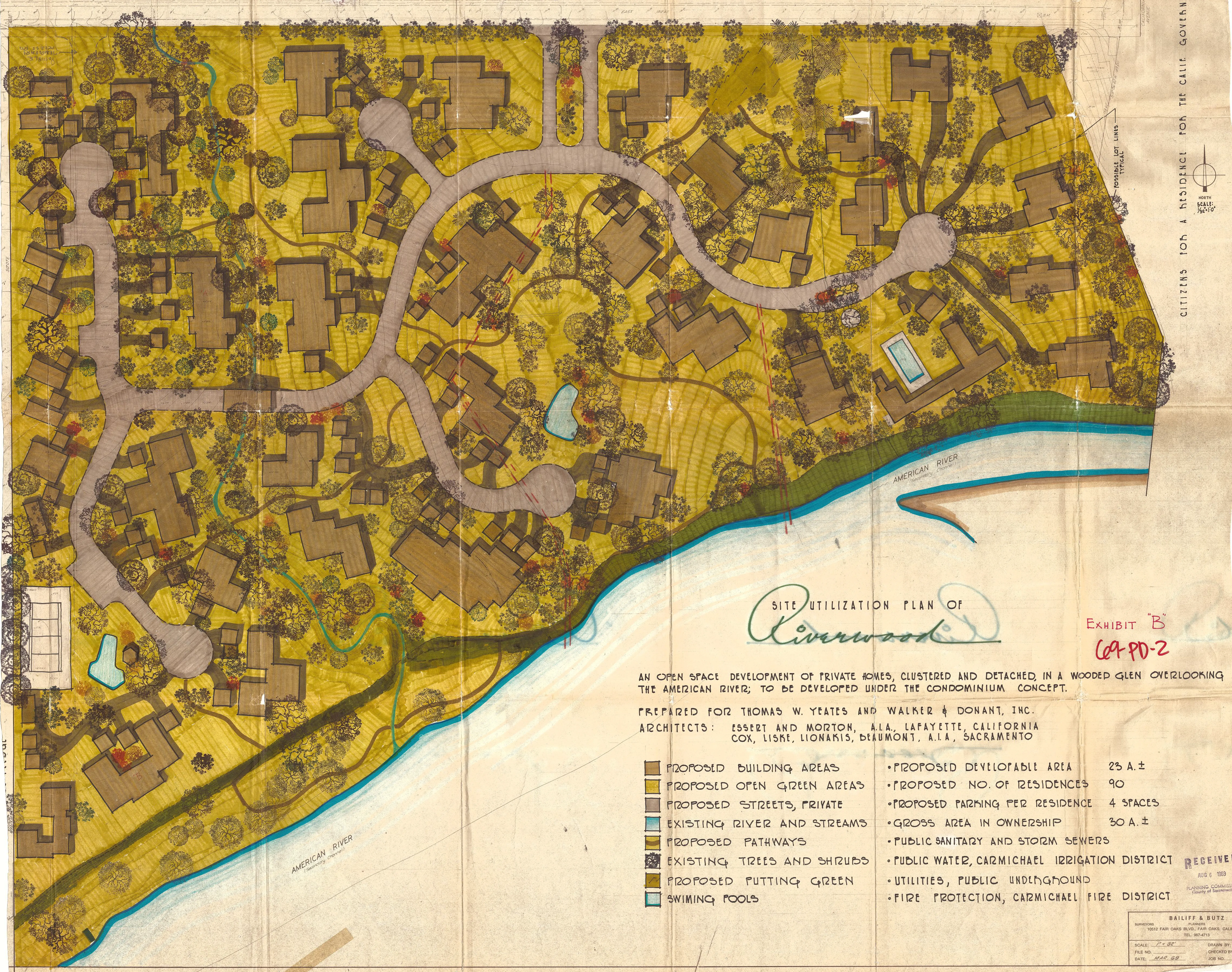
EXHIBIT “C”
Section titled “EXHIBIT “C””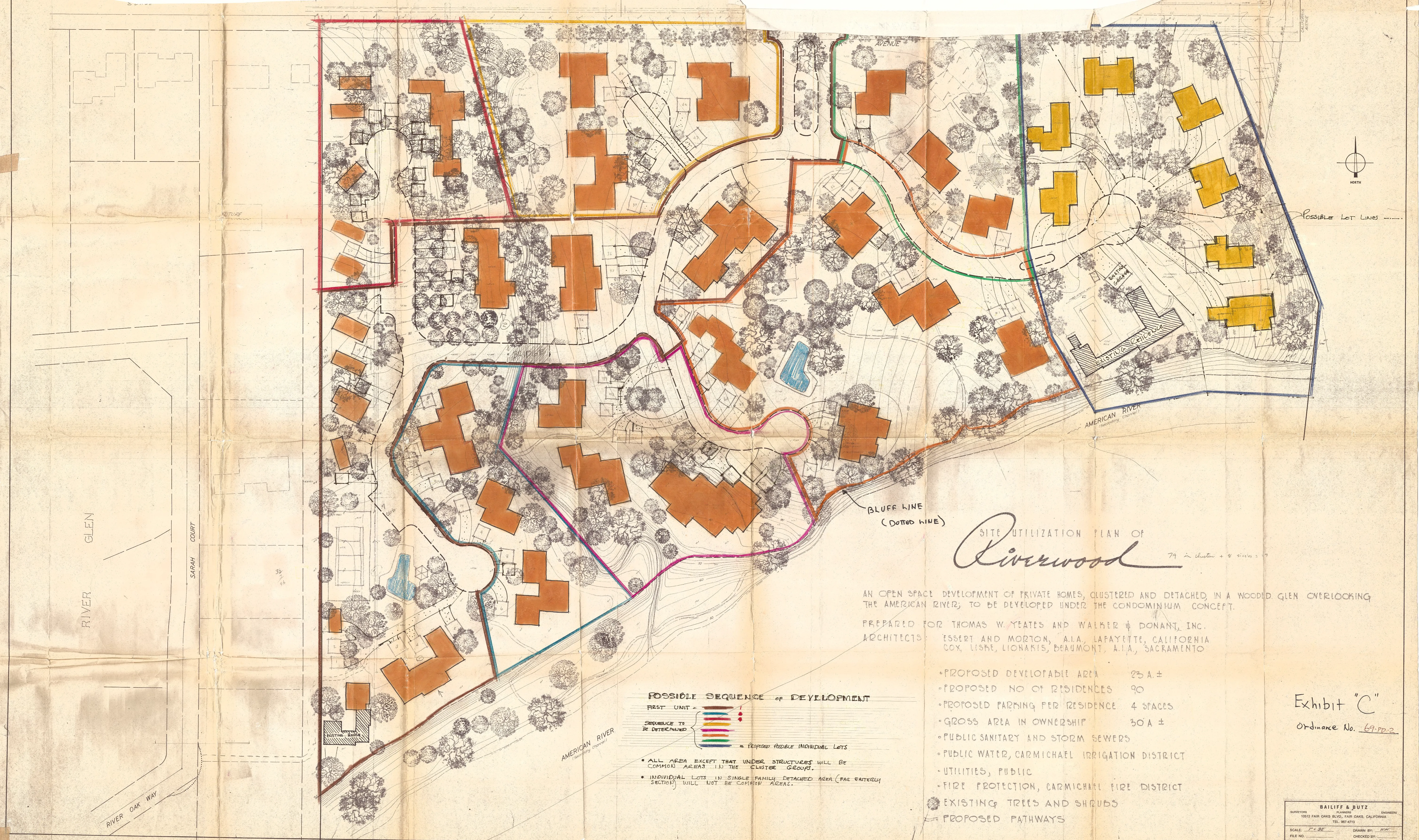
EXHIBIT “D”
Section titled “EXHIBIT “D””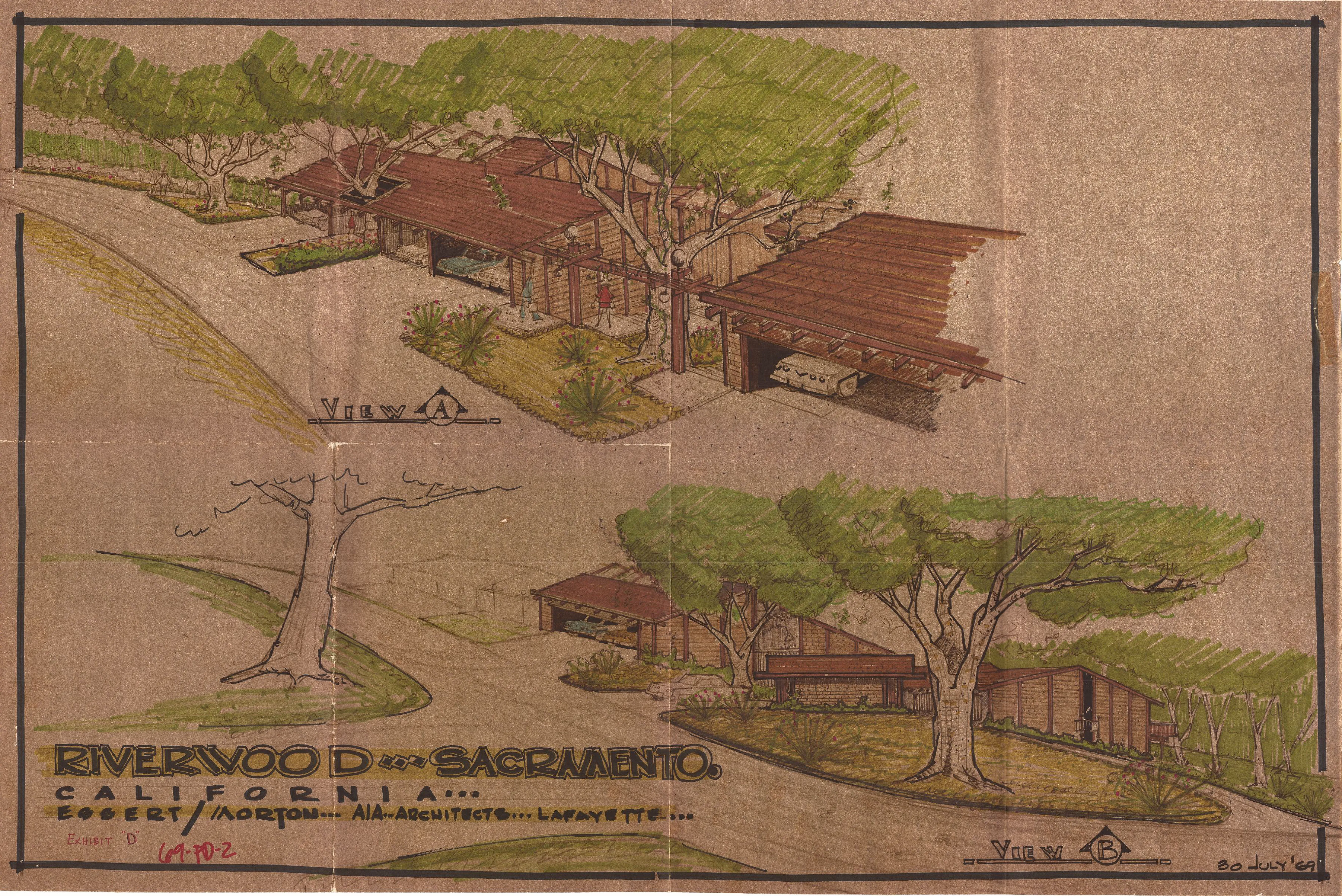
EXHIBIT “E”
Section titled “EXHIBIT “E””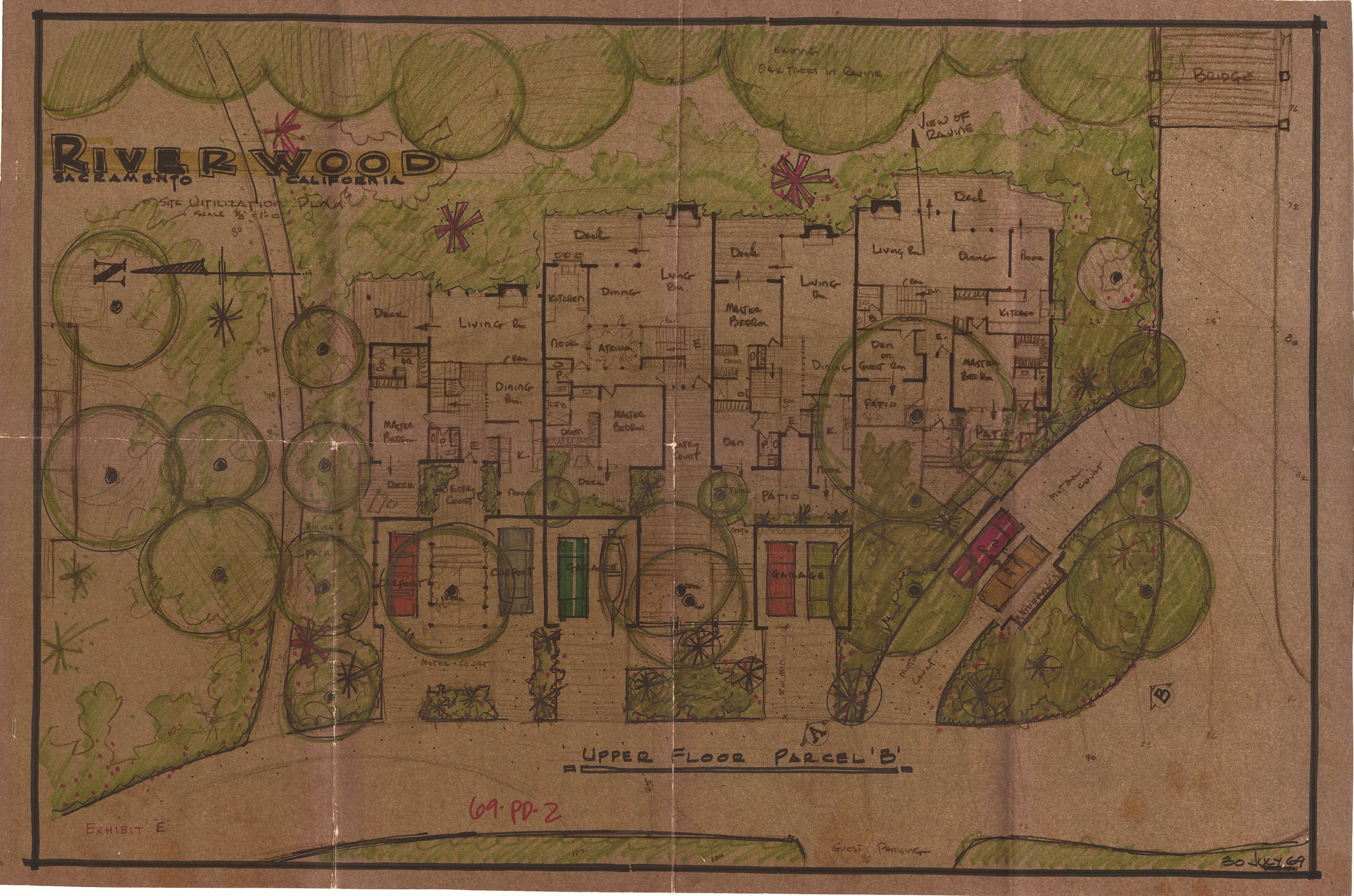
EXHIBIT “F”
Section titled “EXHIBIT “F””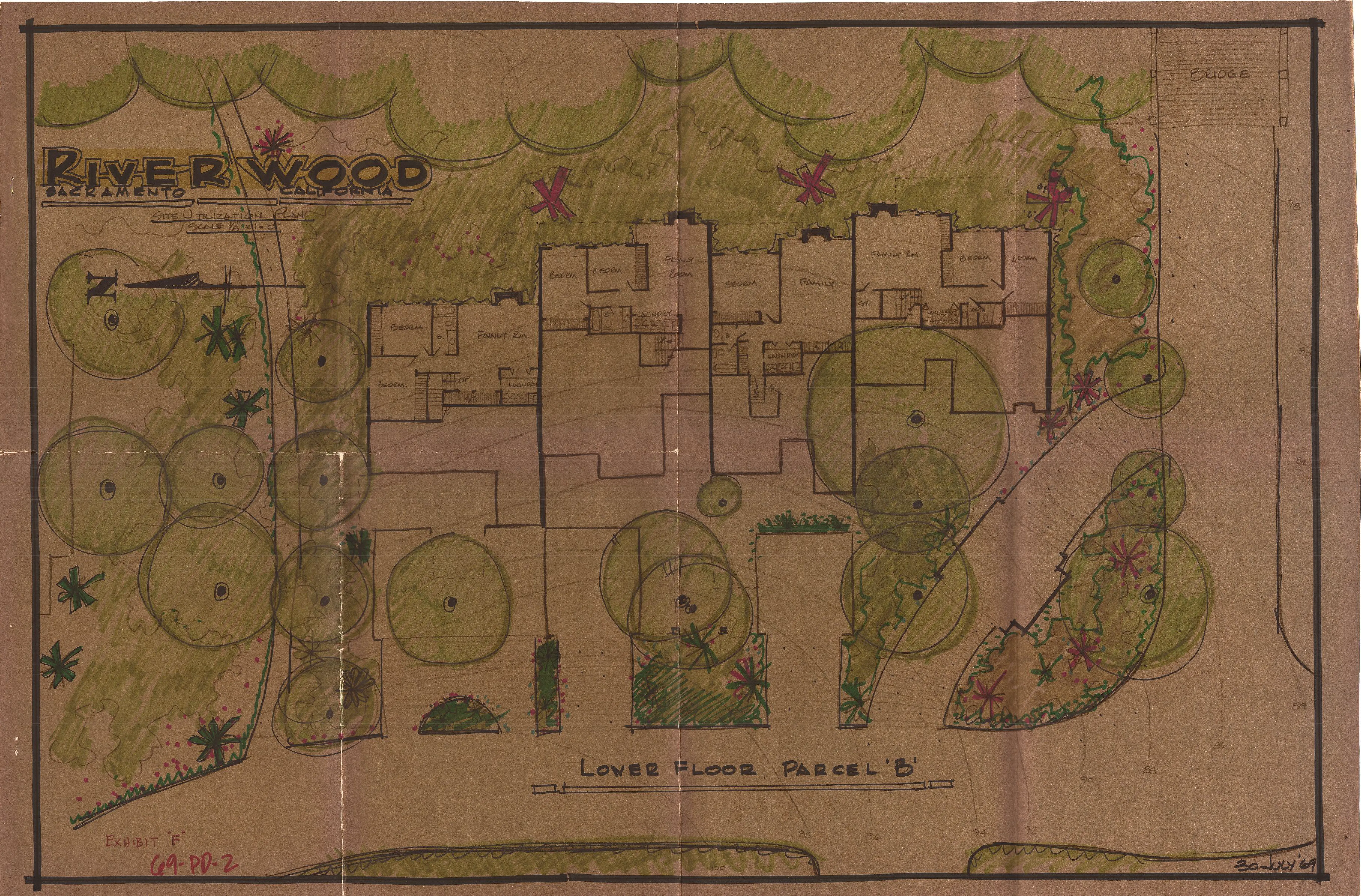
EXHIBIT “G”
Section titled “EXHIBIT “G””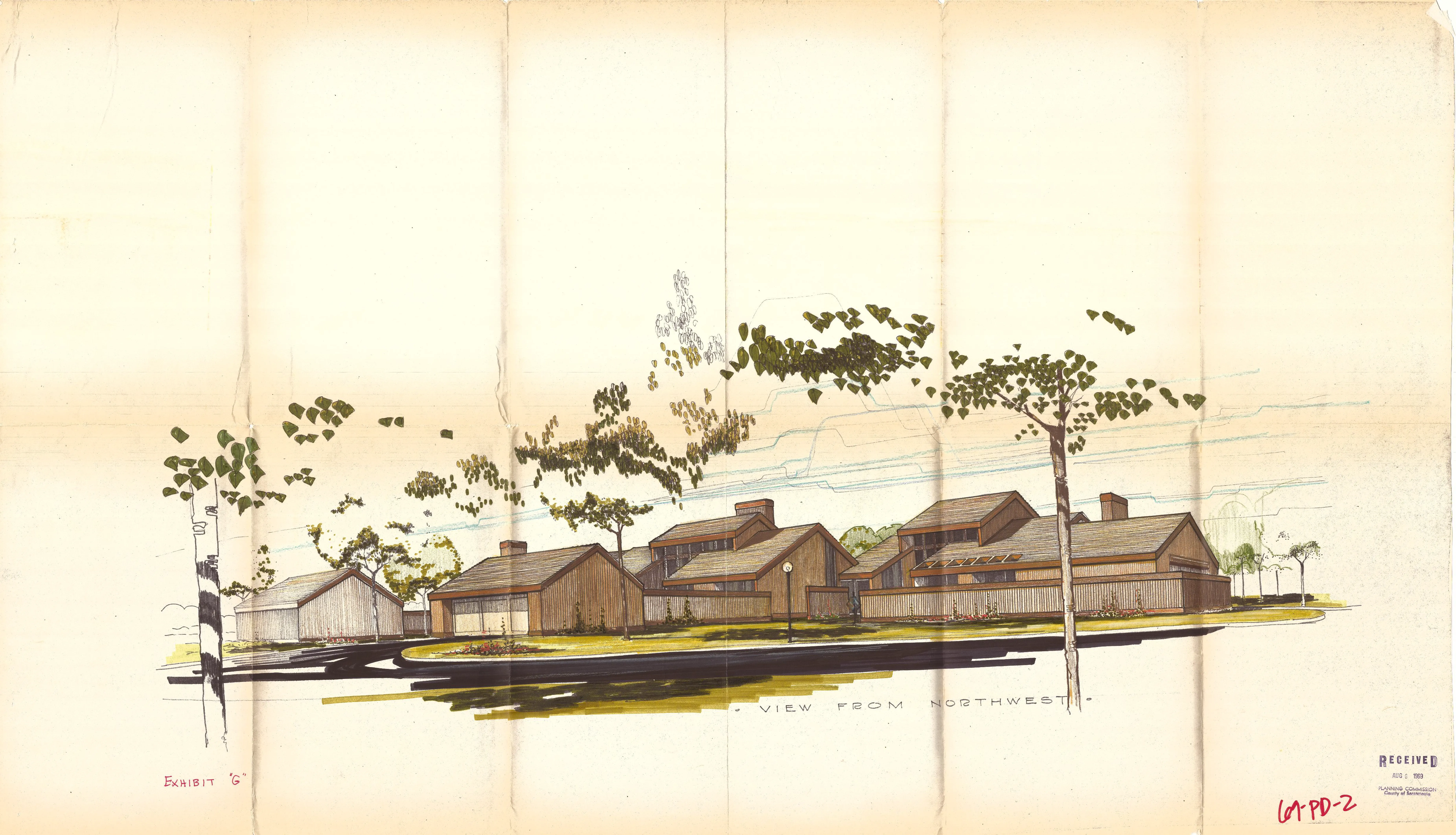
EXHIBIT “H”
Section titled “EXHIBIT “H””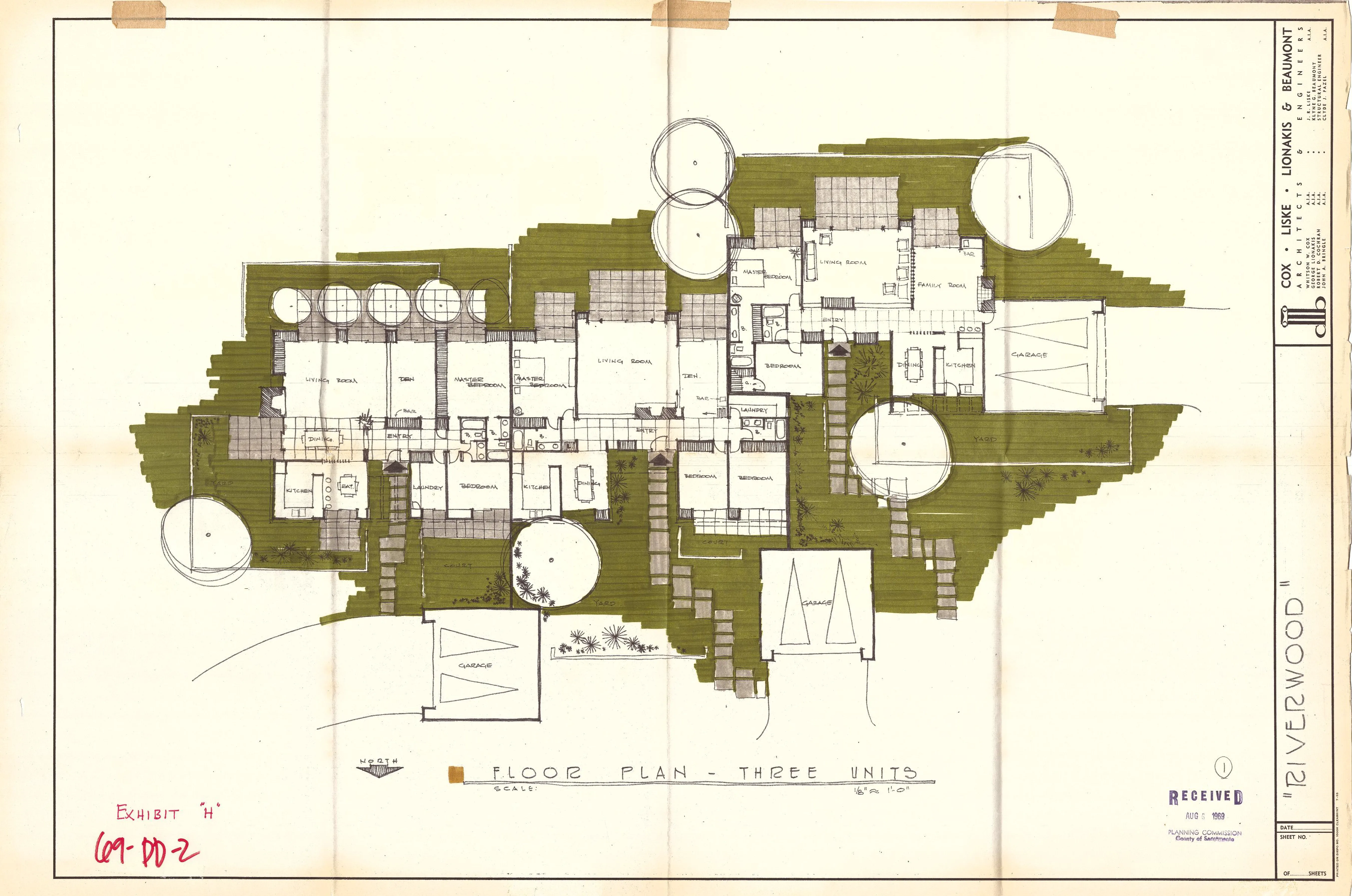
EXHIBIT “I”
Section titled “EXHIBIT “I””This exhibit is intended to depict a cross-hatched area across the eastern side of Riverwood where public access would be provided across from Oak Avenue to Ancil Hoffman Park [See Section 7(E)]. It appears that this easement was never recorded and, by its own provisions, is no longer applicable. This exhibit is not available.
EXHIBIT “D-1”
Section titled “EXHIBIT “D-1””[ADDED 10-05-1977]
This exhibit is missing.
EXHIBIT “D-2”
Section titled “EXHIBIT “D-2””[ADDED 10-05-1977]
This exhibit is missing.
RIVERWOOD UNIT 10 “TOP-OF-THE-HILL” PLANNED DEVELOPMENT ORDINANCE
Section titled “RIVERWOOD UNIT 10 “TOP-OF-THE-HILL” PLANNED DEVELOPMENT ORDINANCE”Ordinance No. 69-PD-2B amended the Riverwood Planned Development to establish a sub-area, known as Riverwood “Top-of-the-Hill” or Riverwood Unit 10. This ordinance regulates the property described in its own Exhibit “A” (the two parcels set forth below) and is governed by its own Sections 1 through 5 and Exhibits 1 through 5. Where silent, regulations defer to the Base Riverwood PD.
Adopted July 26, 1979
69-PD-2B Adopted by Ordinance 69-PD-2B
SECTION 1. PROPERTY REZONED
Section titled “SECTION 1. PROPERTY REZONED”Section 101-201 of the Zoning Code of Sacramento, Ordinance No. SZC 77-110, as amended, which establishes the planned unit development known as Riverwood Planned Development and incorporates said planned development as a part of the Zoning Code of Sacramento County, is amended to change the real property described in Exhibit “A” to provide for development as is further specified in this ordinance.
SECTION 2. EXHIBITS INCORPORATED
Section titled “SECTION 2. EXHIBITS INCORPORATED”Exhibits 1 through 5, inclusive, described generally in this section and attached to this ordinance are incorporated herein and made a part of this ordinance to regulate the property described in Exhibit “A”. The Exhibits are on file in the office of the Department of Planning and Community Development and are a part of this ordinance as if fully set forth herein.
Exhibits:
- 1 - Development Plan entitled Riverwood “Top-of-the-Hill”
- 2 - Floor Plans and Elevations for Units identified as V Units
- 3 - Floor Plans and Elevations for Units identified as W and X Units
- 4 - Floor Plans and Elevations for Units identified as Y and Z Units
- 5 - Tree Map for Riverwood Development (this map shows the location of trees and trees which have been authorized for removal; this map is not to be used to identify the number and type of residential units)
SECTION 3. DEVELOPMENT STANDARDS
Section titled “SECTION 3. DEVELOPMENT STANDARDS”Development shall be limited to seventeen (17) residential units as provided on Exhibit “1”. Dwelling units constructed shall substantially conform to the floor plans and elevations set forth in Exhibits “2” through “4”. The configuration of dwelling unit clusters shall also conform to the provisions of Exhibit “1”. The development shall also be subject to the following conditions:
- Unit X-10 should not exceed thirty (30) feet in height and Units X-11, 12 and 13 should not exceed thirty-two (32) feet in height. The elevations for these X Units are to be measured from existing ground levels to the peak of the roof.
- The X Units may not be constructed closer to the bluff’s edge than as shown on Exhibit “1”. In no event should the proposed decking of the units be allowed to encroach into the twenty-five (25) foot setback area which is established along the bluff.
- Developer shall introduce additional screen planting between the bluff edge and all of the X Units.
- The exterior of all units shall be finished in earthtone colors and the roofs shall be natural in appearance.
- The cul-de-sac private drive shall be designed to avoid disturbance of the twenty (20) inch oak tree shown within the cul-de-sac driveway.
- The sixteen (16) inch oak tree shown south and west of the concrete block wall shall be protected as well as all other oaks growing in that area.
- Developer shall be permitted, subject to receiving concurrence from the Parks and Recreation Department, to remove selected olive and other non-native trees that are competing with oak trees located between the bluffs edge and the Z-type units.
- The nine (9) inch and eight (8) inch oak trees shown south of Units Y-14 and Y-15 shall not be disturbed.
- Turf block or other porous materials shall be used if paving is to occur within the dripline of any oak tree not identified for removal on the Plan.
- All existing trees located between the bluffs’ edge and the X-type units shall be preserved unless shown for removal on the Tree Map, Exhibit “5”.
- The turn-around radius for the cul-de-sac private road shall be subject to approval of the Carmichael Fire District.
- Final development plans for the project including each of the units therein is subject to approval by the Planning and Community Development Department.
SECTION 4. CONTINUING REGULATION
Section titled “SECTION 4. CONTINUING REGULATION”Except as expressly provided by this ordinance, the provision of Ordinance No. 69-PD-2 shall apply to the development authorized by this ordinance.
SECTION 5. EFFECTIVE DATE
Section titled “SECTION 5. EFFECTIVE DATE”This ordinance shall take effect and be in full force and effect on and after thirty (30) days from the date of its passage hereof, and before the expiration of fifteen (15) days from the date of its passage it shall be published once with the names of the members of the Board of Supervisors voting for and against the same, said publication to be made in a newspaper of general circulation published in the County of Sacramento.
PASSED AND ADOPTED by the Board of Supervisors of the County of Sacramento, State of California, at a regular meeting thereof, this 26th day of July, 1979, by the following vote, to wit:
- AYES: Supervisors, Collin, Johnson, Sheedy, Wade, Smoley
- NOES: Supervisors, None
- ABSENT: Supervisors, None
Chairperson of the Board of Supervisors of Sacramento County, California
(SEAL)
ATTEST: Clerk of the Board of Supervisors
Publish in the Daily Recorder 8/8/79. Send one affidavit and two publication bills with notice attached to each.
EXHIBIT “A” (69-PD-2B)
Section titled “EXHIBIT “A” (69-PD-2B)”The two parcels described below constitute the property description for the property subject to this amendment to the Riverwood Planned Development. The descriptions are recorded in surveyor’s abbreviated form.
Parcel #1
POR LOT 211 OF CARMICHAEL COLONY BEG AT A PT ON THE SL’Y LINE OF COVERED BRIDGE RD SD POB LOC S 03°13’17” E 27.89 FT TH S 19°15’ E 96.94 FT TH S 31°26’20” E TO THE SL’Y LINE OF SD LOT 211 TH S 65°35’ W ALG SD SL’Y LINE TO THE SW COR OF SD LOT 211 TH N 23°34’20” W ALG SD WL’Y LINE TO THE SL’Y LINE OF COVERED BRIDGE RD TH SL’Y & EL’Y ALG SD SL’Y LINE TO THE POB CONTG 28.400± IN FORMER PARCEL 283-300-59 PTN.
Parcel #2
POR OF LOT 212 CARMICHAEL COLONY DESC AS BEG AT NE COR OF LOT B RIVERWOOD UNIT NO. 1 TH FROM SD POB S 46.39 FT TH S 32° W 235.21 FT TH S 16°30’ E 29 FT TH S 33°30’ E 201.5 FT TH S 03°33’ W TO A PT LOC ON S LINE OF SD LOT 212 TH EL’Y ALG SD S LINE TO A PT LOC ON THE E LINE OF SD LOT 212 TH NL’Y ALG SD E LINE TO A PT LOC ON S LINE OF COVERED BRIDGE RD (PVT) TH NWL’Y ALG SD S LINE OF RD TO THE POB CONTG 2.34± IN FORMER PARCEL 282-300-59 POR.
EXHIBIT 1
Section titled “EXHIBIT 1”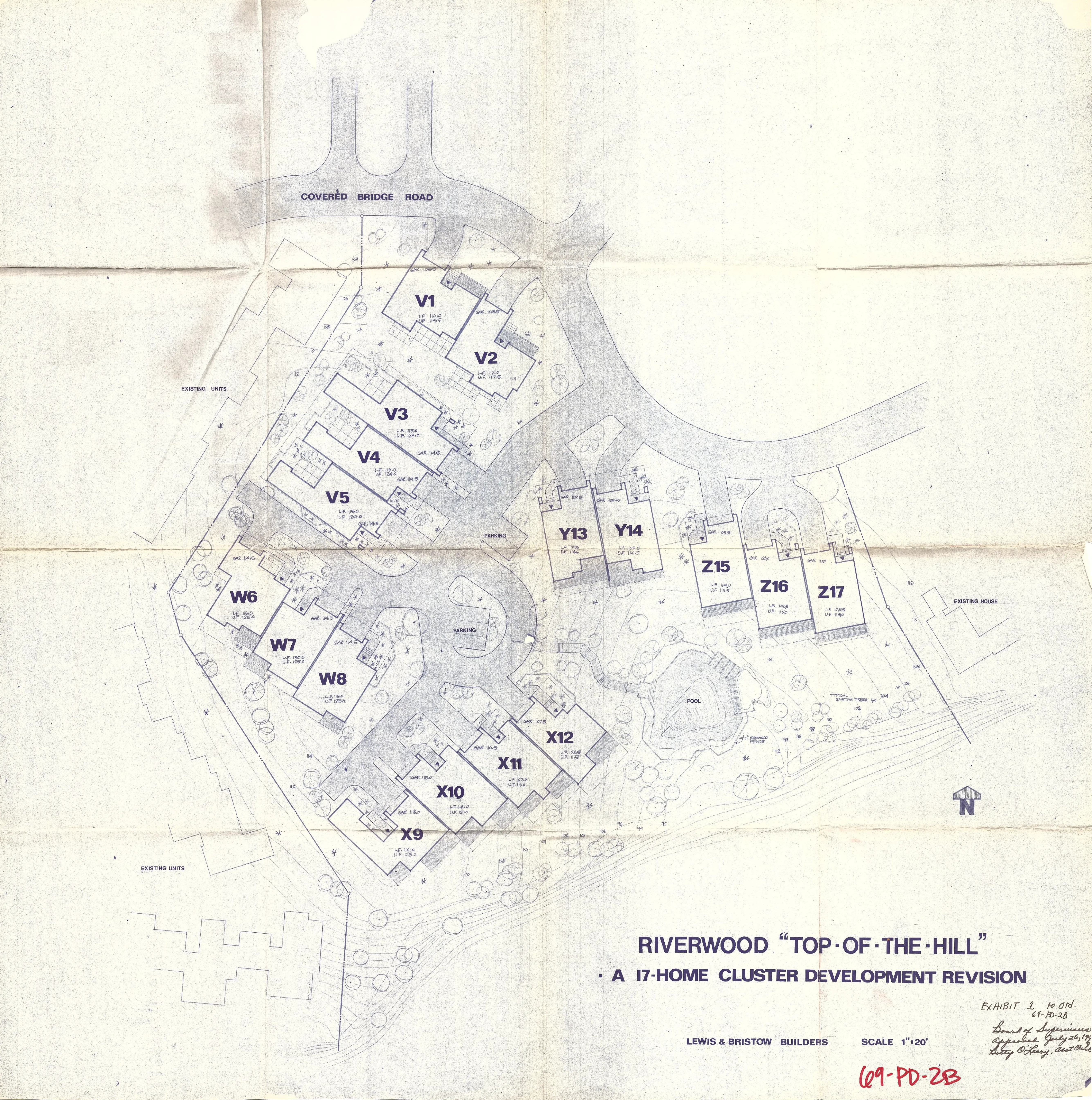
EXHIBIT 2
Section titled “EXHIBIT 2”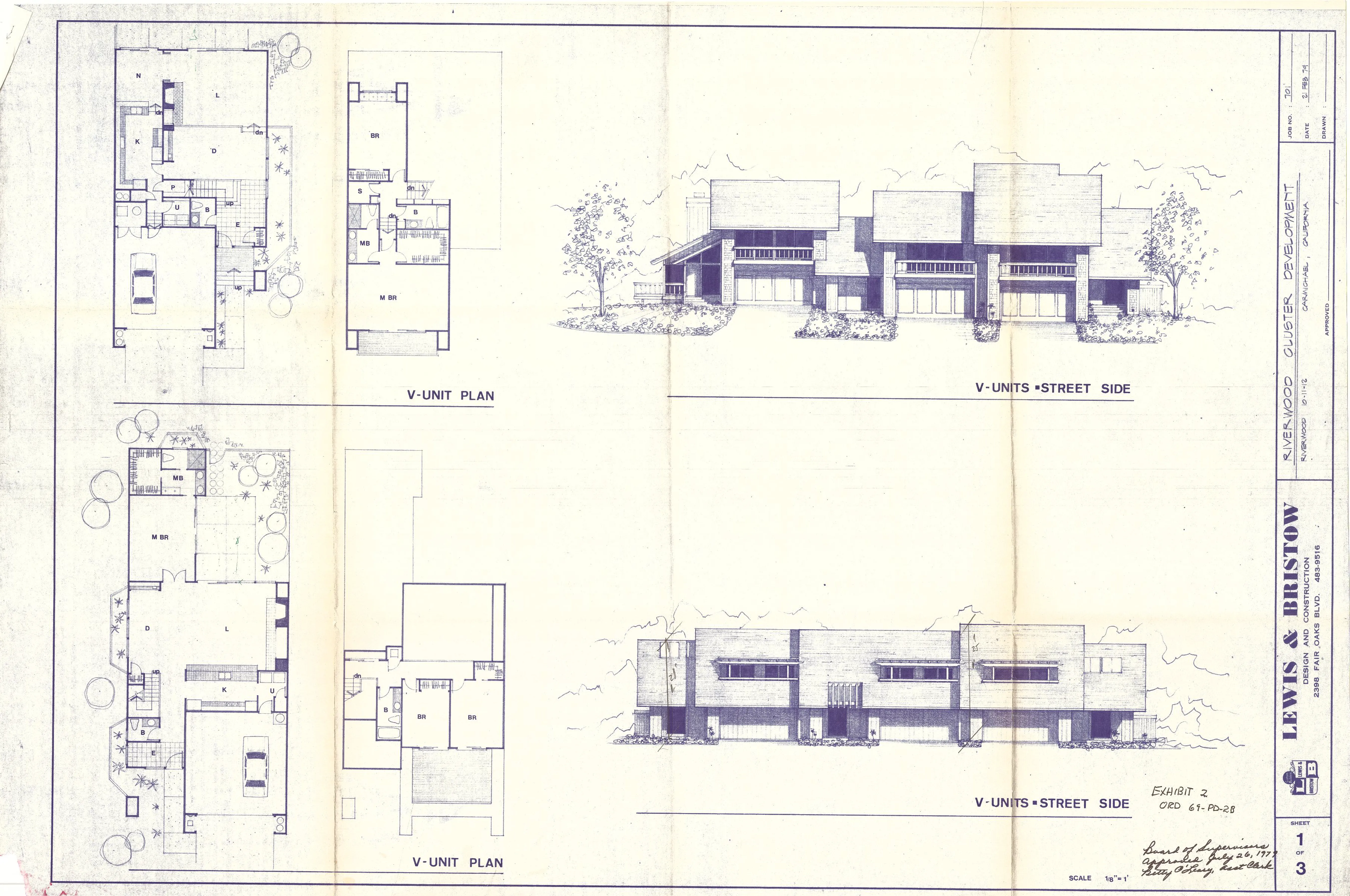
EXHIBIT 3
Section titled “EXHIBIT 3”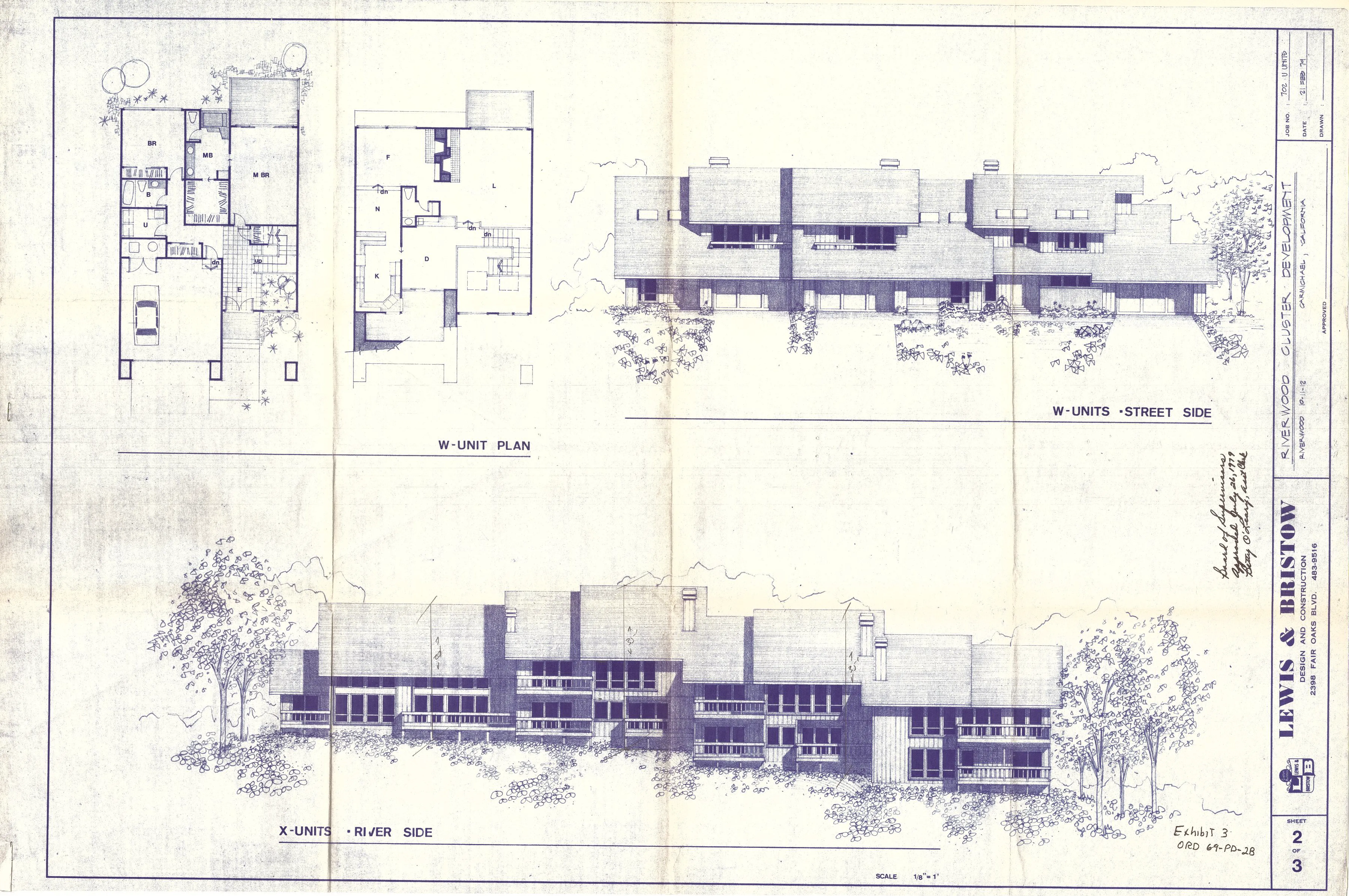
EXHIBIT 4
Section titled “EXHIBIT 4”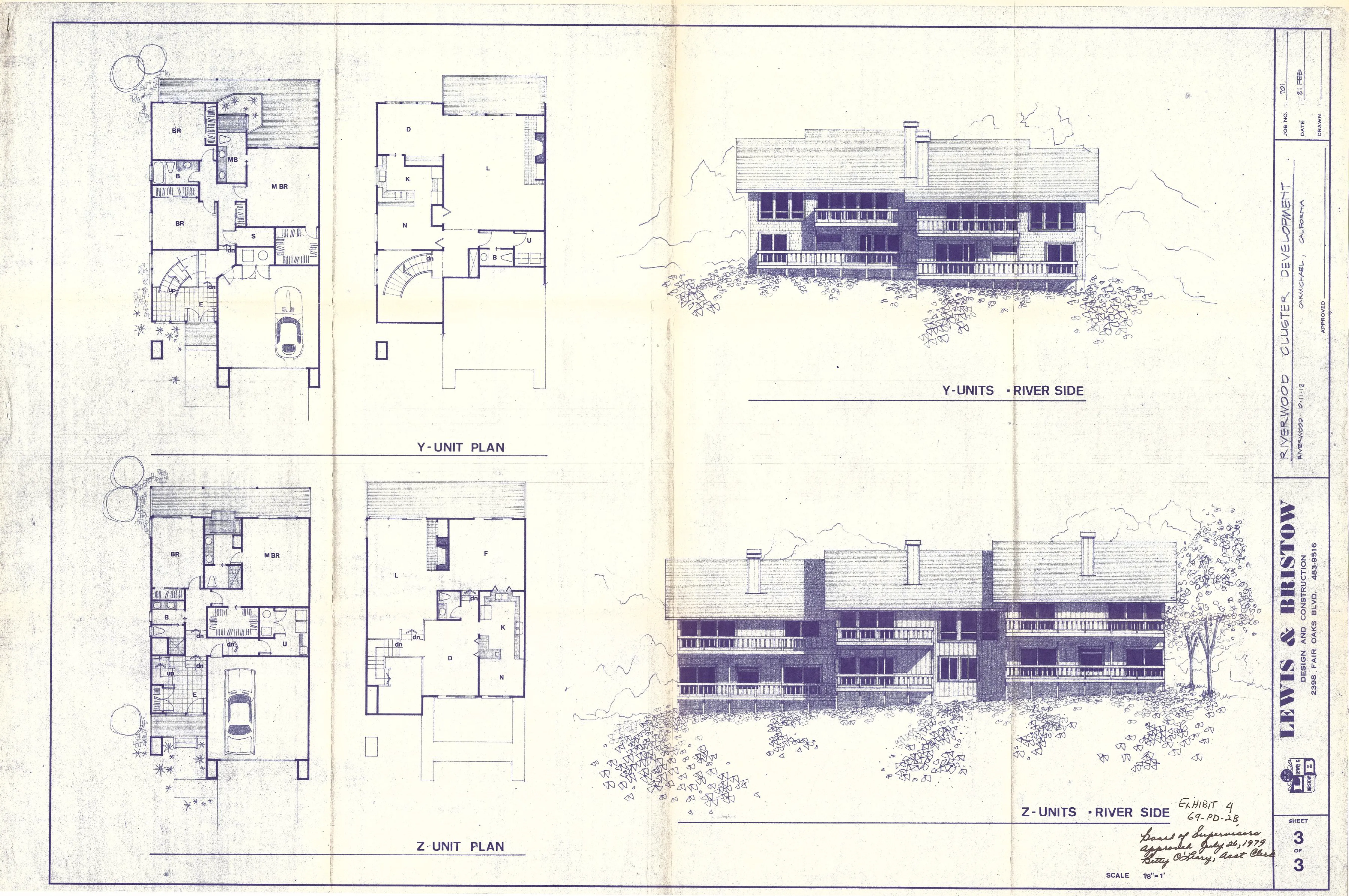
EXHIBIT 5
Section titled “EXHIBIT 5”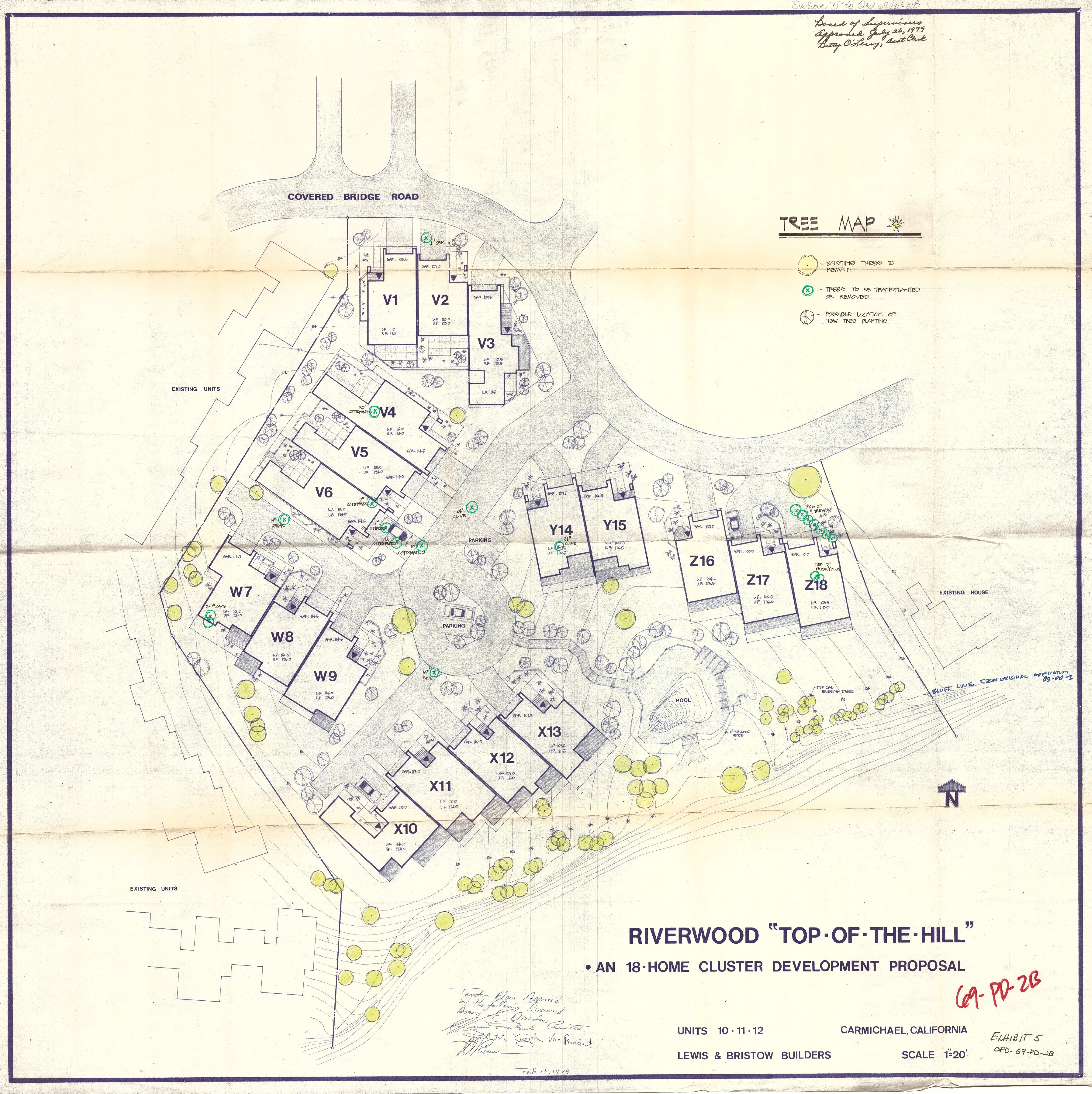
APPENDIX — SUPPORTING DOCUMENT: CORPORATION GRANT DEED
Section titled “APPENDIX — SUPPORTING DOCUMENT: CORPORATION GRANT DEED”The following recorded Corporation Grant Deed is included in the source PDF. It is not part of the ordinance text, but relates to the Lot 50 pool/spa provision added by Ordinance 69-PD-2(a). It conveyed a small portion of Lot “L” of Riverwood Unit No. 6 from the Riverwood Homeowners Association to Cuttle Construction Co., Inc.
For value received, RIVERWOOD HOMEOWNERS ASSOCIATION, a California corporation, grants to CUTTLE CONSTRUCTION CO., INC., a California corporation, all that real property situate in the County of Sacramento, State of California, described as follows:
All that portion of Lot “L” of Riverwood Unit No. 6, according to the official plat thereof, filed in the office of the Recorder of Sacramento County, California, on April 28, 1976, in Book 103 of Maps, Map No. 5, described as follows:
Beginning at a Southeast corner of Lot 50 of said Riverwood Unit No. 6 located South 79°06’09” West 38.93 feet from the Southeast corner of Lot 215 of Carmichael Colony, according to the official plat thereof, filed in the office of the Recorder of Sacramento County, California, on March 11, 1910, in Book 10 of Maps, Map No. 9; thence from said point of beginning, along the East line of said Lot 50, North 18.00 feet to a point located South 9.00 feet from a Northeast corner of said Lot 50; thence at a right angle to the East line of said Lot 50 East 8.00 feet; thence at a right angle to the last described line South 32.00 feet; thence at a right angle to the last described line West 49.50 feet to a Southeast corner of said Lot 50; thence along the East and South lines of said Lot 50 North 14.00 feet and East 41.50 feet to the point of beginning.
Executed this 17th day of April, 1977, by the Riverwood Homeowners Association (William W. Applegate, President; and Secretary).