Lake Knoll Estates PD
Sacramento County Zoning Code
Lake Knoll Estates Planned Development Ordinance
Section titled “Sacramento County Zoning Code Lake Knoll Estates Planned Development Ordinance”Adopted June 9, 1971
Amended August 14, 1974 & October 8, 1975 & October 29, 1975 & July 14, 1976
71-PD-5
Adopted by ZMA #2769
Amended by 71-PD-5A & 71-PD-5B & 71-PD-5C & 71-PD-5D
LAKE KNOLL ESTATES — PARCELS “A” THROUGH “F”
Section titled “LAKE KNOLL ESTATES — PARCELS “A” THROUGH “F””SECTION 1.
Section titled “SECTION 1.”[AMENDED 07-14-1976]
The area described in Exhibit “G” was removed from the regulation of this ordinance and established as a separate planned unit development (Lake Knolls Apartments), governed by the provisions set forth in the second part of this document.
Paragraph 47 of Subsection B of Section 2 of Ordinance No. 534, as amended, which incorporates Comprehensive Zoning Plan, Unit No. 356/200, and Paragraph 56 of Subsection B of Section 2 of Ordinance No. 534, as amended, which incorporates Comprehensive Zoning Plan, Unit No. 364/200, are amended to change the real property described in Exhibits “A”, “B”, and “C” on said comprehensive zoning plans to R-2-A (PD) Multiple Family Residential (Planned Development) Zone, and to change the real property described in Exhibit “D” on said comprehensive zoning plans to R-1-A (PD) Single Family Residential (Planned Development) Zone, and to change the real property described in Exhibit “E” on said comprehensive zoning plans to “BP” (PD) Business and Professional Office (Planned Development) Zone, and to change the real property described in Exhibit “F” on said comprehensive zoning plans to R-1-A (PD) Single Family Residential (Planned Development) Zone. Exhibits “A”, “B”, “C”, “D”, “E”, and “F” are attached to this ordinance and are incorporated herein and made a part of this ordinance.
SECTION 2.
Section titled “SECTION 2.”[AMENDED 08-14-1974][AMENDED 10-29-1975]
Exhibits 1 through 17, inclusive, described generally in this section and attached to this ordinance are incorporated herein and made a part of this ordinance to regulate the property described in Exhibits “A”, “B”, “C”, “D”, “E”, and “F”. The exhibits are on file in the office of the Clerk of the Board of Supervisors and are a part of this ordinance as if fully set forth herein.
Exhibits:
- 1 - Detailed Layout Plan
- 2 and 3 - Typical floor plans of Apartment Units A, B, C, and D
- 4 through 8, inclusive - Typical floor plans of Types A, B, C, D, and E Townhouses
- 9 - Typical floor plan of Type F Patio House
- 10 - Typical floor plan and elevation of Recreation Buildings
- 11 - Typical elevations of Types A, B, C, D, and E Townhouses, and Type F Patio Houses
- 12A and 12B - Typical elevations of Apartment Units A, B, C, and D
- 13A and 13B - Typical elevations of Business and Professional Offices
- 14 - Phasing and Detailed Layout Plan
- 15 - Location Plan of Carport Conversion to Garages
- 16 - Typical plans and elevations of Garages
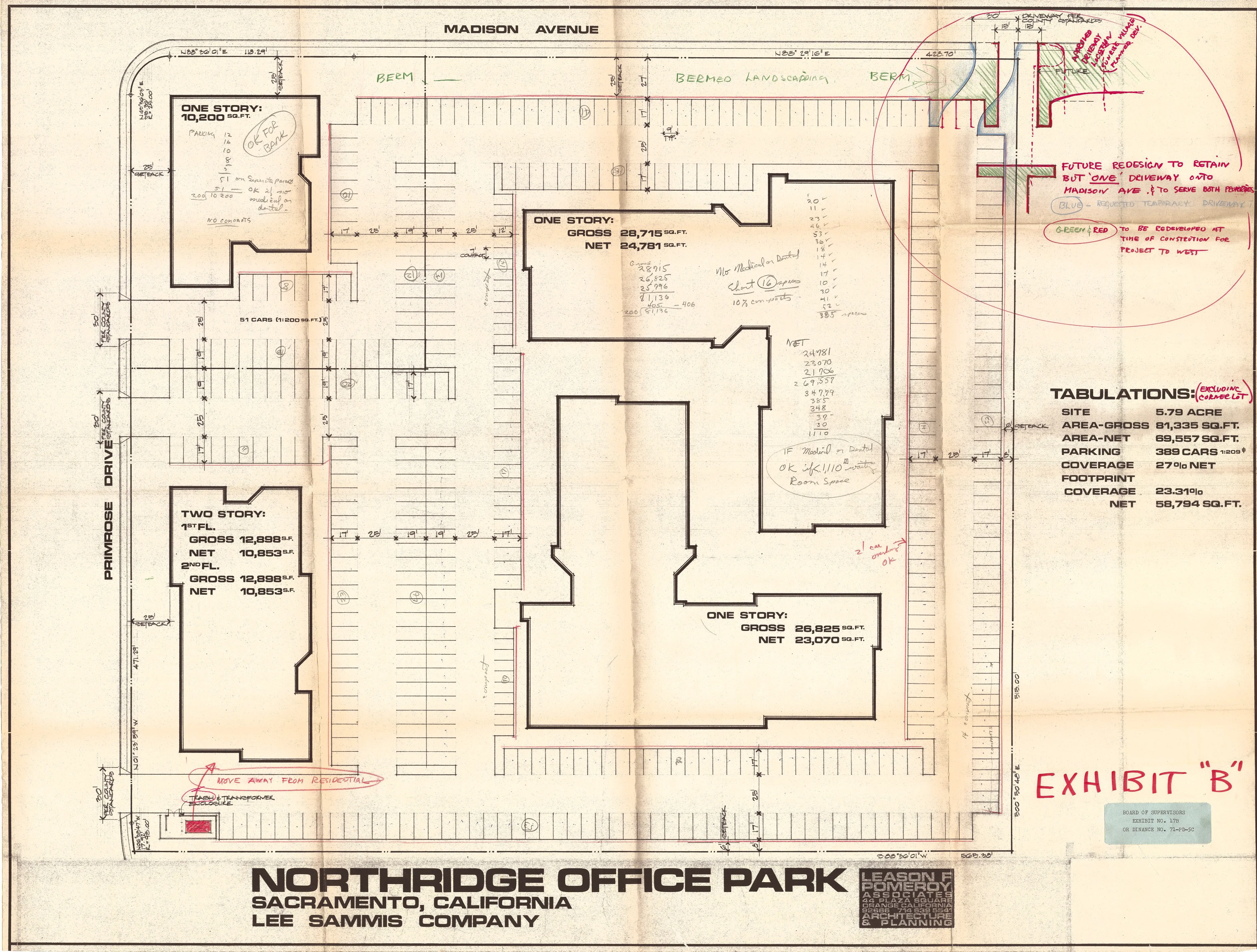
- 17A and 17B - Plan of Northridge Office Park
SECTION 3.
Section titled “SECTION 3.”[AMENDED 08-14-1974][AMENDED 10-29-1975]
The location, setback, configuration and arrangement of buildings, streets, private roads, parking areas, driveways, recreational areas, pools and lakes, walkways, screening mounds and berms, landscaping and open areas, and common areas shall be as shown on Exhibit 1.
The location, configuration, and arrangement of the office buildings, pools, fountains, landscaped berms, and other landscaping features located within the property described in Exhibit “E” shall be as shown on Exhibit 17A, except that the location of the trash and transformer enclosure shall be moved to the location shown on Exhibit 17B. The layout and arrangement of the parking, traffic patterns, and driveways shall be as shown on Exhibit 17B. A temporary driveway onto Madison Avenue shall be constructed in the location and configuration shown in blue on Exhibit 17B. Should the property to the East be required by the County of Sacramento at the time of its development to install a joint use driveway at the location and configuration shown in red on Exhibit 17B, or with a similar configuration approved by County at that time, then, and in that event, the temporary driveway as shown in blue on Exhibit 17B shall be closed, and no direct access to Madison Avenue shall be allowed other than a joint use driveway as shown in green and red on said Exhibit 17B.
The Board of Supervisors recognizes that in construction of the project minor deviations from the Detailed Layout Plan (Exhibit 1) may occur. The Board, having considered this possibility, has determined that insubstantial deviations from the Detailed Layout Plan do not constitute an amendment to the Plan and delegates to the Planning Commission the authority to approve any such changes.
Provided, however, that those buildings shown on Exhibit 15 with the exception of Units 14 through 18 and 21 through 34 as indicated with a red “X” on Exhibit 15 shall be permitted to be constructed with garages instead of carports in the parking areas as shown on Exhibit 1.
SECTION 4.
Section titled “SECTION 4.”[AMENDED 10-08-1975]
Dwelling Units constructed within those areas designated as 1-A and 1-E as shown on Exhibit No. 1 shall substantially conform to the elevations and floor plans set forth in Exhibits 2, 3, 12A, and 12B. It is the intent of the Board of Supervisors to permit variations in the types of units from those designated on Exhibit No. 1 and to permit the developer to choose to construct one or two bedroom dwelling units within areas 1-A and 1-E, provided however:
- The number of dwelling units in area 1-A do not exceed 44 units, and the number of dwelling units in area 1-E do not exceed 92 units;
- The number and configuration of dwelling unit clusters and the number of dwelling units within each cluster conforms to the number of clusters and configurations set forth in Exhibit No. 1.
SECTION 5.
Section titled “SECTION 5.”[AMENDED 08-14-1974]
Dwelling Units constructed within those areas designated as 1-B and 1-D as shown on Exhibit No. 1 and within those areas designated as Phases II, III, IV, V, and VI in Exhibit 14 shall substantially conform to the elevations and floor plans set forth in Exhibits 4, 5, 6, 7, 8, 9, and 11. The garages constructed with those units which may be constructed with garages as provided in Section 3 as amended shall substantially conform to the floor plan and elevations set forth in Exhibit 16. It is the intent of the Board of Supervisors to permit variations in the types of units from those designated on Exhibit No. 1, and to permit the developer to choose to construct two or three bedroom dwelling units within said areas 1-B and 1-D, provided however:
- The number of dwelling units in area 1-B do not exceed 35, and the number of dwelling units in area 1-D do not exceed 50;
- The number and configuration of dwelling unit clusters, and the number of dwelling units within each cluster conforms to the number and configuration set forth in Exhibit No. 1.
SECTION 6.
Section titled “SECTION 6.”[AMENDED 10-29-1975]
Business and Professional Offices constructed within the area described in Exhibit “E” shall substantially conform to the configuration and elevations set forth in Exhibits 13A and 13B.
SECTION 7.
Section titled “SECTION 7.”The recreation buildings shall substantially conform to the elevations and floor plans set forth in Exhibit No. 10.
SECTION 8.
Section titled “SECTION 8.”The uses permitted and the height and yard requirements in the area described in Exhibit “D” shall be as specified in Section 5 of said Ordinance No. 534, as amended.
SECTION 9.
Section titled “SECTION 9.”The driveways and parking areas shall conform to the number, layout, and configuration set forth in Exhibit 1, and to the parking standards set forth in Subsection C, Section 19 of Ordinance No. 534, as amended.
SECTION 10.
Section titled “SECTION 10.”The sequence of development of the planned development shall be as set forth in Exhibit No. 14. Construction of Phase 1-A shall begin not later than twelve (12) months from the effective date of this ordinance, and the entire project shall be completed not later than sixty (60) months from the effective date of this ordinance. The Board of Supervisors hereby delegates to the Planning Director the authority to amend the sequence of the construction schedule, provided however, that the Planning Director shall not be authorized to extend the construction schedule.
SECTION 11.
Section titled “SECTION 11.”The location, setback, configuration, and arrangement of buildings, streets, private roads, parking areas, driveways, recreational areas, pools and lakes, streams, landscaping and open areas within those areas designated as Phases II, III, IV, V, and VI, shall be as shown on Exhibit 14. Development plans shall be submitted to the Planning Commission for approval prior to any development on the property described in Exhibit “F” for public hearing after notice being given as provided in Paragraph 2(a), Subsection C, Section 23 of Ordinance 534, as amended.
SECTION 12.
Section titled “SECTION 12.”Developer and/or the owners shall record a subdivision map of the property described in Exhibits “A”, “B”, “C”, “D”, “E”, and “F”.
SECTION 13.
Section titled “SECTION 13.”During the public hearings on this ordinance the Planning Commission and the Board of Supervisors determined that:
- The proposed development will carry out the intent of the General Plan.
- The proposed development is of sufficient size and is designed so as to provide a desirable environment within its own boundaries.
- The proposed development is compatible with existing and proposed land uses in the surrounding area.
- Exceptions to the standard requirements of the Basic Zoning Ordinance are justified by the design of the development.
- The arrangement of dwellings and mixing of dwelling types is justified by larger and more usable open spaces.
- There is adequate assurance that all public improvement will be installed at the scheduled times as required by the Public Works Department.
- There is adequate assurance that the development schedule will be met.
- The existing or proposed utility services are adequate for the uses and population densities proposed.
SECTION 14.
Section titled “SECTION 14.”The variance provision of Section 21 of said Ordinance No. 534, as amended, shall not apply to this Ordinance.
SECTION 15.
Section titled “SECTION 15.”Violation of the provisions of this Ordinance or Exhibits made part of this Ordinance shall be deemed a violation of the Basic Zoning Ordinance No. 534, as amended.
SECTION 16.
Section titled “SECTION 16.”The Articles of Incorporation and Bylaws of the Homeowner Association, a California corporation, the prospective owner of the common area, shall be approved by the County Counsel prior to the issuance of the building permit for any dwelling unit.
SECTION 17.
Section titled “SECTION 17.”The Declaration of Covenants, Conditions and Restrictions which relate to the common area shall be approved by the County Counsel prior to the issuance of any building permits for dwelling units.
SECTION 18.
Section titled “SECTION 18.”This Ordinance shall take effect and be in full force on and after thirty (30) days from the date of its passage hereof, and before the expiration of fifteen (15) days from the date of its passage it shall be published once with the names of the members of the Board of Supervisors voting for and against the same, said publication to be made in a newspaper of general circulation published in the County of Sacramento.
PASSED AND ADOPTED by the Board of Supervisors of the County of Sacramento, State of California, this 9th day of June, 1971, by the following vote, to wit:
- AYES: Supervisors, KLOSS, MELARKEY, PHELAN, SHEEDY
- NOES: Supervisors, GUALCO
- ABSENT: Supervisors, NONE
Chairman of the Board of Supervisors of Sacramento County, California
(SEAL)
ATTEST: Clerk of the Board of Supervisors
Publish in the Sacramento Legal Press 6/21/71. Send one affidavit and two publication bills with notice attached to each.
EXHIBIT “A”
Section titled “EXHIBIT “A””Parcel description, Phase I. All that certain real property situate in the County of Sacramento, State of California, described as follows:
All that portion of projected Section 1, Township 9 North, Range 6 East, Mount Diablo Meridian, located within the San Juan Grant, described as follows:
Beginning at a point in the South line of Madison Avenue, a public road 100.00 feet in width from which the Northeast corner of Lot 141 as said lot is shown and so designated on the official “Plat of Greenridge Heights Unit No. 4” recorded in the office of the Recorder of Sacramento County, California in Book 60 of Maps, Map No. 22, bears South 88°36’01” West 924.14 feet distant; thence, from said point of beginning, along said South line, North 88°36’01” East 98.00 feet to a point of cusp; thence, leaving said South line, along the arc of a curve, concave to the Southeast, having a central angle of 90°00’00” and a radius of 25.00 feet, said arc being subtended by a chord bearing South 43°36’01” West 35.36 feet; thence, tangent to said curve, South 01°23’59” East 476.29 feet; thence, along the arc of a tangent curve to the left having a radius of 104.00 feet, said arc being subtended by a chord bearing South 31°03’42” East 102.94 feet; thence, tangent to said curve, South 60°43’25” East 65.94 feet; thence, along the arc of a tangent curve to the right having a radius of 146.00 feet, said arc being subtended by a chord bearing South 30°43’25” East 146.00 feet; thence, tangent to said curve, South 00°43’25” East 444.24 feet; thence, South 89°16’35” West 21.00 feet; thence, South 51°16’35” West 259.48 feet; thence, South 89°16’35” West 148.00 feet; thence, North 36°12’01” West 112.57 feet; thence, South 89°16’35” West 135.00 feet to the Northeasterly corner of Lot 206 as said lot is shown and so designated on said “Plat of Greenridge Heights Unit No. 4”; thence, along the exterior boundaries of said “Greenridge Heights Unit No. 4” the following three (3) bearings and distances: (1) North 51°24’30” West 255.68 feet, (2) North 38°35’30” East 194.50 feet, and (3) North 12°59’25” East 90.39 feet to the most Easterly corner of Lot 163 as shown and so designated on said “Plat of Greenridge Heights Unit No. 4”; thence, leaving said exterior boundaries, North 63°34’46” East 143.20 feet; thence, North a distance of 130.00 feet; thence, North 49°00’00” West 110.00 feet; thence, North 83°00’00” West 100.00 feet; thence, South 61°00’00” West 110.00 feet to the most Northerly corner of Lot 162 as said lot is shown and so designated on said “Plat of Greenridge Heights Unit No. 4”; thence, along the exterior boundaries of said Greenridge Heights Unit No. 4, the following eight (8) bearings and distances: (1) South 54°19’30” West 45.00 feet, (2) South 45°00’00” West 215.15 feet, (3) North 51°24’30” West 264.97 feet, (4) North 00°37’26” West 92.00 feet, (5) North 16°22’52” East 136.46 feet, (6) North 06°51’47” West 107.21 feet, (7) North 81°53’56” West 39.71 feet, and (8) North 01°23’59” West 174.53 feet to the Southeast corner of Lot 141 as said lot is shown on said “Plat of Greenridge Heights Unit No. 4”; thence, leaving said exterior boundary, along the arc of a non-tangent curve, concave to the North, having a central angle of 40°32’09” and a radius of 55.00 feet, said arc being subtended by a chord bearing North 68°19’57” East 38.11 feet to a point of reverse curve; thence, along the arc of a tangent curve to the right, having a radius of 45.00 feet, said arc being subtended by a chord bearing South 54°04’45” East 87.98 feet; thence, radial to said curve, South 49°26’00” East 32.30 feet; thence, along the arc of a tangent curve to the right having a radius of 163.00 feet, said arc being subtended by a chord bearing South 21°00’00” East 155.22 feet; thence, leaving said curve, North 88°36’01” East 249.34 feet; thence, South 17°25’50” East 140.46 feet; thence, along the arc of a non-tangent curve, concave to the South, having a central angle of 57°52’40” and a radius of 163.00 feet, said arc being subtended by a chord bearing South 78°29’30” East 157.74 feet; thence, tangent to said curve, South 49°33’10” East 205.27 feet; thence, along the arc of a non-tangent curve, concave to the Southeast, having a central angle of 32°45’30” and a radius of 170.00 feet, said arc being subtended by a chord bearing North 61°12’41” East 95.88 feet; thence, tangent to said curve, North 77°35’26” East 72.21 feet; thence, along a tangent curve to the left having a radius of 25.00 feet, said arc being subtended by a chord bearing North 38°05’44” East 31.80 feet; thence, tangent to said curve, North 01°23’59” East 470.46 feet; thence, along a tangent curve to the left, having a radius of 25.00 feet, said arc being subtended by a chord bearing North 46°23’59” West 35.36 feet to the point of beginning and containing 16.45 acres of land, more or less.
EXHIBIT “B”
Section titled “EXHIBIT “B””Parcel description, Phase II, Project A. All that certain real property situate in the County of Sacramento, State of California, described as follows:
All that portion of projected Section 1, Township 9 North, Range 6 East, Mount Diablo Meridian, located within the San Juan Grant, described as follows:
Beginning at the Northeast corner of Lot 141 as said lot is shown and so designated on the official “Plat of Greenridge Heights Unit No. 4” recorded in the office of the Recorder of Sacramento County California, in Book 60 of Maps, Map No. 22; thence, from said point of beginning, along the South line of Madison Avenue, a public road 100.00 feet in width, North 88°36’01” East 498.14 feet; thence, South 01°23’59” East 200.00 feet; thence, South 43°36’01” West 100.00 feet; thence, South 88°36’01” West 249.34 feet; thence, along the arc of a non-tangent curve, concave to the Southwest having a central angle of 32°54’25” and a radius of 163.00 feet, said arc being subtended by a chord bearing North 32°58’48” West 92.33 feet; thence, tangent to said curve, North 49°26’00” West 32.30 feet; thence, along the arc of a non-tangent curve, concave to the Southwest, having a central angle of 155°42’36” and a radius of 45.00 feet, said arc being subtended by a chord bearing North 54°04’50” West 87.99 feet to a point of reverse curve; thence, along the arc of a tangent curve to the right, having a radius of 55.00 feet, said arc being subtended by a chord bearing South 68°19’56” West 38.10 feet to the Southeast corner of said Lot 141; thence, along the East line of said Lot 141, North 01°23’59” West 130.31 feet to the point of beginning and containing 2.56 acres of land, more or less.
EXHIBIT “C”
Section titled “EXHIBIT “C””Parcel description, Phase III, Project B. All that certain real property situate in the County of Sacramento, State of California, described as follows:
All that portion of projected Section 1, Township 9 North, Range 6 East, Mount Diablo Meridian, located within the San Juan Grant, described as follows:
Beginning at a point in the South line of Madison Avenue, a public road 100.00 feet in width from which the Northeast corner of Lot 141, as said lot is shown and so designated on the official “Plat of Greenridge Heights Unit No. 4” recorded in the office of the Recorder of Sacramento County, California, in Book 60 of Maps, Map No. 22, bears South 88°36’01” West 498.14 feet distant; thence, from said point of beginning, along said South line, North 88°36’01” East 426.00 feet; thence, along the arc of a tangent curve to the right having a radius of 25.00 feet, said arc being subtended by a chord bearing South 46°23’59” East 35.36 feet; thence, tangent to said curve, South 01°23’59” East 470.46 feet; thence, along the arc of a tangent curve to the right having a radius of 25.00 feet, said arc being subtended by a chord bearing South 38°05’44” West 31.80 feet; thence, tangent to said curve, South 77°35’26” West 72.21 feet; thence, along the arc of a tangent curve to the left having a radius of 170.00 feet, said arc being subtended by a chord bearing South 61°12’41” West 95.88 feet; thence, leaving said curve, North 49°33’10” West 205.27 feet; thence, along the arc of a tangent curve to the left having a radius of 163.00 feet, said arc being subtended by a chord bearing North 78°29’30” West 157.74 feet; thence, radial to said curve, North 17°25’50” West 140.46 feet; thence, North 43°36’01” East 100.00 feet; thence, North 01°23’59” West 200.00 feet to the point of beginning and containing 5.32 acres of land, more or less.
EXHIBIT “D”
Section titled “EXHIBIT “D””Parcel description, Phase II, Project C (R-1-A). All that certain real property situate in the County of Sacramento, State of California, described as follows:
All that portion of projected Section 1, Township 9 North, Range 6 East, Mount Diablo Meridian, located within the San Juan Grant, described as follows:
Beginning at the most Northerly corner of Lot 162 as said lot is shown and so designated on the official “Plat of Greenridge Heights Unit No. 4”, recorded in the office of the Recorder of Sacramento County, California, in Book 60 of Maps, Map No. 22; thence, from said point of beginning, North 61°00’00” East 110.00 feet; thence, South 88°00’00” East 100.00 feet; thence, South 49°00’00” East 110.00 feet; thence, South a distance of 130.00 feet; thence, South 63°34’46” West 143.20 feet to the most Easterly corner of Lot 163 as shown on said “Plat of Greenridge Heights Unit No. 4”; thence, along the boundary of said “Greenridge Heights Unit No. 4”, North 34°56’15” West 263.54 feet to the point of beginning and containing 1.12 acres of land, more or less.
EXHIBIT “E”
Section titled “EXHIBIT “E””Parcel description, Phase III, Commercial Area. All that certain real property situate in the County of Sacramento, State of California, described as follows:
All that portion of projected Section 1, Township 9 North, Range 6 East, Mount Diablo Meridian, located within the San Juan Grant, described as follows:
Beginning at a point in the South line of Madison Avenue, a public road 100.00 feet in width from which the Northeast corner of Lot 141, as said lot is shown and so designated on the official “Plat of Greenridge Heights Unit No. 4,” recorded in the office of the Recorder of Sacramento County, California, in Book 60 of Maps, Map No. 22, bears South 88°36’01” West 1022.14 feet distant; thence, from said point of beginning, along said South line, North 88°36’01” East 124.26 feet; thence, continuing along said South line North 88°29’16” East 428.78 feet; thence, South 00°50’48” East 520.00 feet; thence, South 88°36’01” West 571.48 feet; thence, along the arc of a non-tangent curve, concave to the East, having a central angle of 09°52’46” and a radius of 104.00 feet, said arc being subtended by a chord bearing North 06°20’22” West 17.91 feet; thence, tangent to said curve, North 01°23’59” West 476.29 feet; thence, along the arc of a tangent curve to the right having a radius of 25.00 feet, said arc being subtended by a chord bearing North 43°36’01” East 35.36 feet to the point of beginning and containing 6.86 acres of land, more or less.
EXHIBIT “F”
Section titled “EXHIBIT “F””Lake Knoll Estates legal description. All that real property situate in the County of Sacramento, State of California described as follows:
All that portion of the Southwest one-quarter of Projected Section 1, T 9 N, R 6 E, M.D.M., in the San Juan Grant, being a portion of the parcel delineated as “Percy K. McMillan 114.080 Acres” on that certain “Record of Survey the Percy K. McMillan Property located in Section 1 and 2, T 9 N, R 6 E, and Section 6, T 9 N, R 7 E, M.D.M.,” recorded in the office of the Recorder of Sacramento County, California, in Book 9 of Surveys, Survey No. 33, described as follows:
Beginning at the Northeast Corner of Lot 206 as said Lot is shown upon the official “Plat of Greenridge Heights Unit No. 4” recorded in the office of the Recorder of Sacramento County, California in Book 60 of Maps, Map No. 22; thence from said point of beginning along the exterior boundary of said Greenridge Heights the following four (4) courses and distances: (1) South 00°43’25” East 263.11 feet; (2) South 89°16’35” West 105.00 feet; (3) South 83°23’16” West 81.61 feet; and (4) South 38°35’30” West 125.00 feet; thence leaving said Easterly boundary along the arc of a non-tangent curve to the left, concave to the Northeast with a 280.00 feet radius, said arc being subtended by a chord bearing South 71°03’57” East 188.38 feet; thence, tangent to said curve, North 89°16’35” East 514.90 feet; thence South 00°43’25” East 335.21 feet; thence South 89°16’35” West 614.25 feet to the Easterly boundary of said Greenridge Heights Unit No. 4; thence along said Easterly boundary, South 89°16’35” West 108.00 feet, and South 00°43’25” East 603.12 feet to the most Southeast corner of said Greenridge Heights Unit No. 4; thence leaving said Greenridge Heights Unit No. 4, North 89°16’35” East 1,264.76 feet to the Southeast corner of the hereinabove referred to “Percy K. McMillan 114.080 Acres” tract of land; thence along the Easterly boundary of said “114.080 Acres” tract of land, North 00°50’48” West 2,099.38 feet; thence South 89°36’01” West 571.48 feet; thence around a non-tangent curve to the left with a radius of 104.00 feet, the chord of which bears South 36°00’03” East 86.99 feet; thence South 60°43’35” East 65.94 feet; thence around a 146 foot radius curve to the right the chord of which bears South 03°43’35” East 146.00 feet; thence South 00°43’25” East 444.24 feet; thence South 89°16’35” West 21.00 feet; thence South 51°16’35” West 259.48 feet; thence South 89°16’35” West 148.00 feet; thence North 36°12’01” West 112.57 feet; thence South 89°16’35” West 135.00 feet to the point of beginning, containing 38.54 acres more or less.
EXHIBIT 1
Section titled “EXHIBIT 1”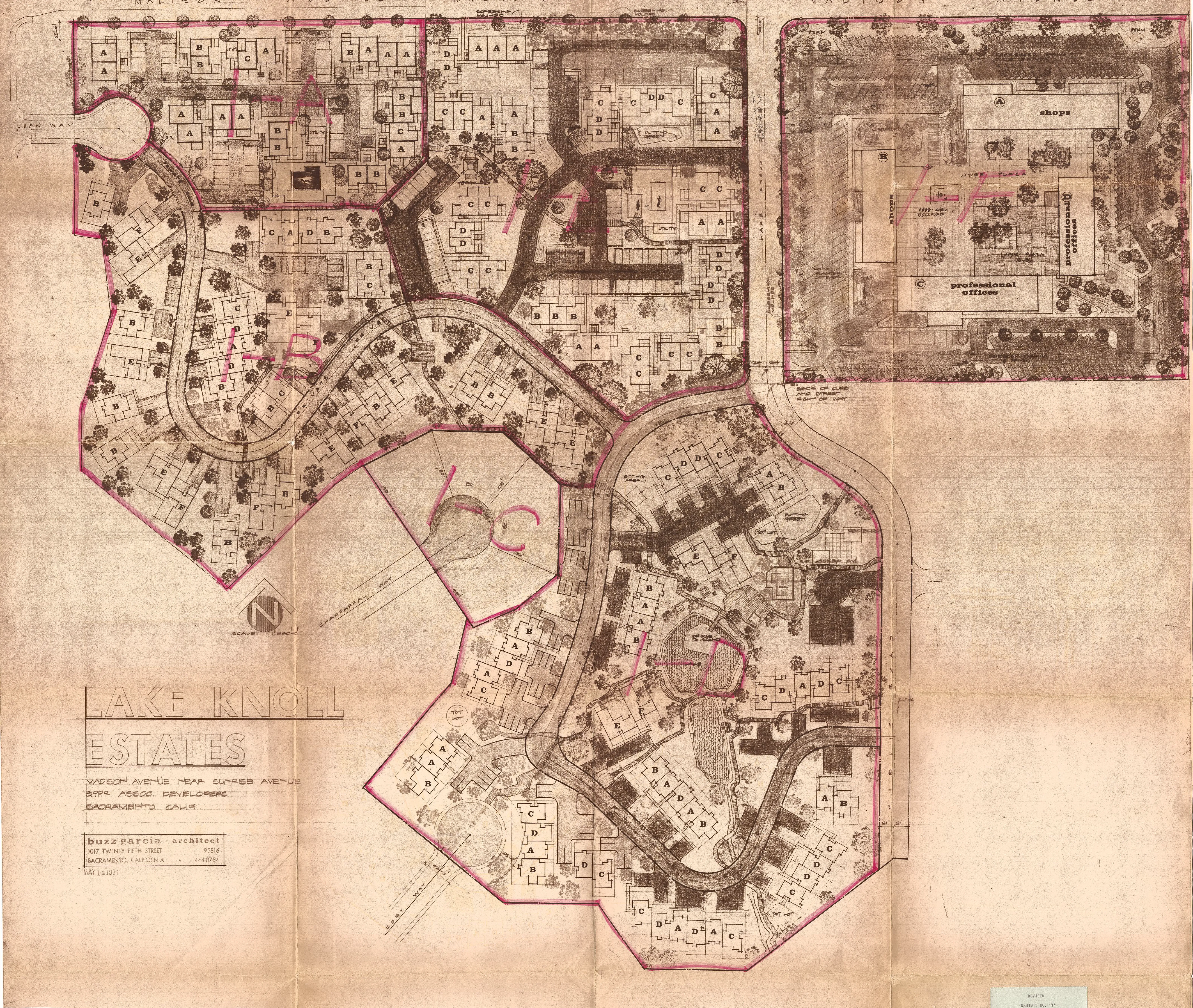
EXHIBIT 2
Section titled “EXHIBIT 2”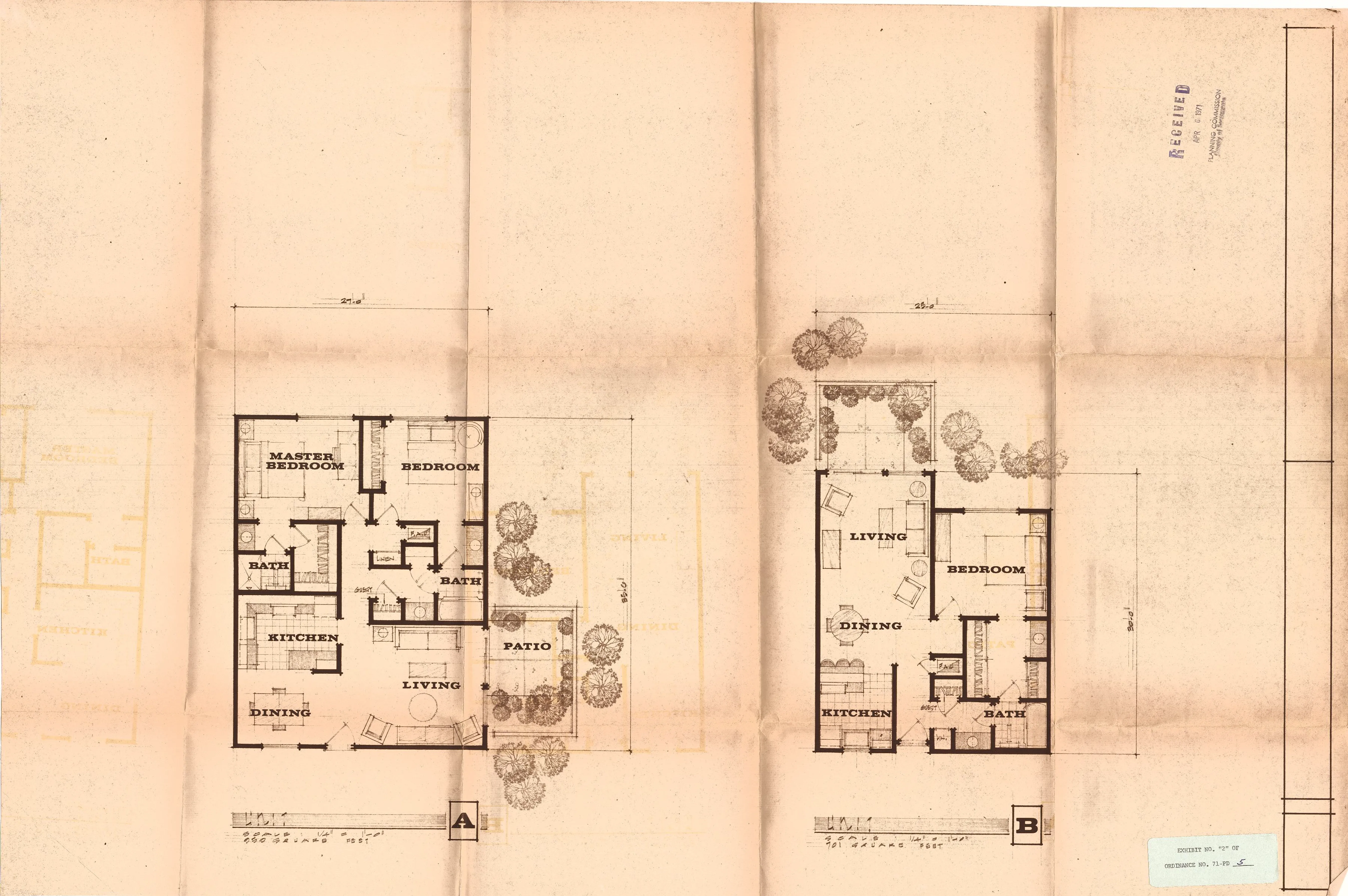
EXHIBIT 3
Section titled “EXHIBIT 3”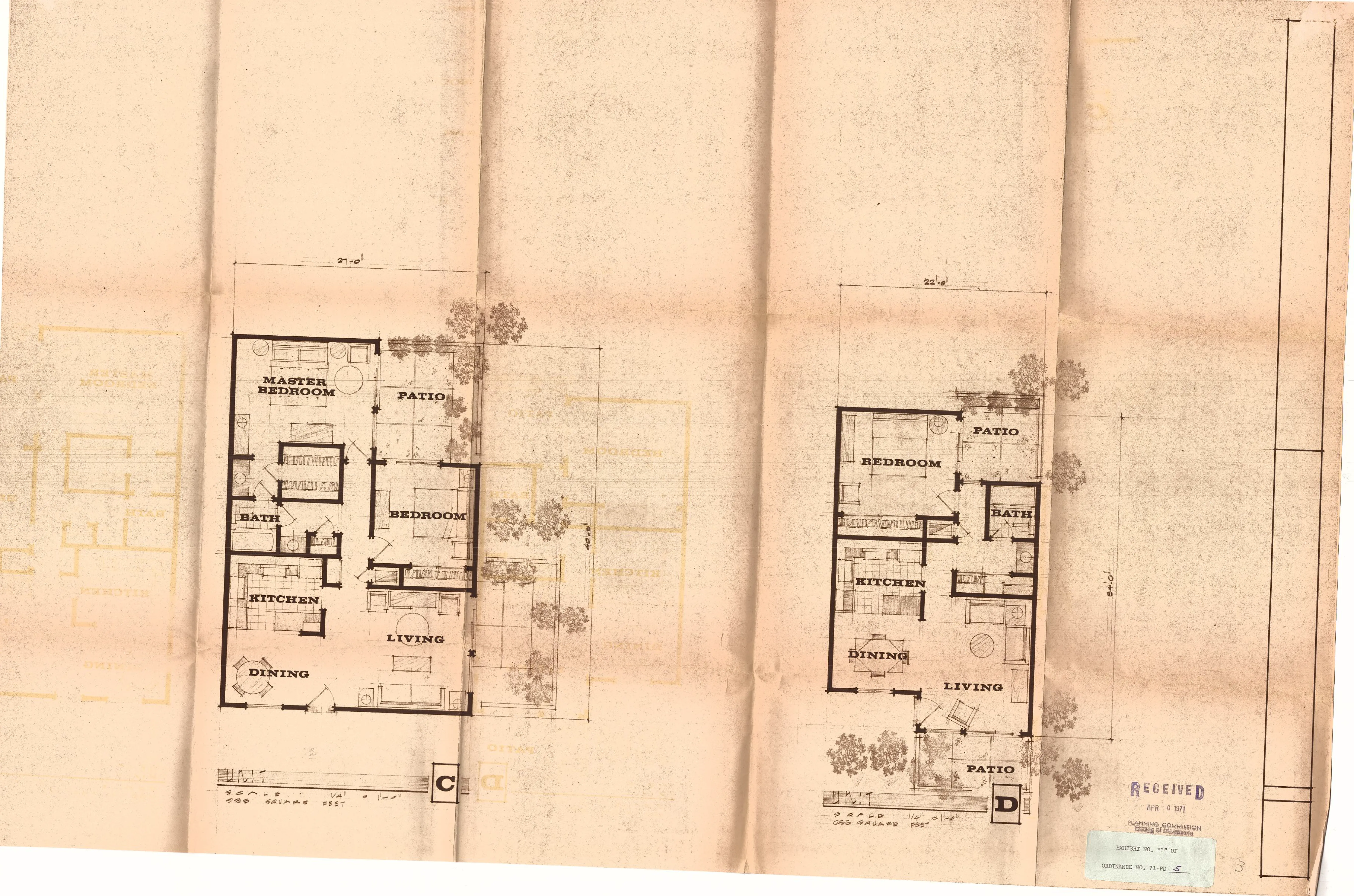
EXHIBIT 4
Section titled “EXHIBIT 4”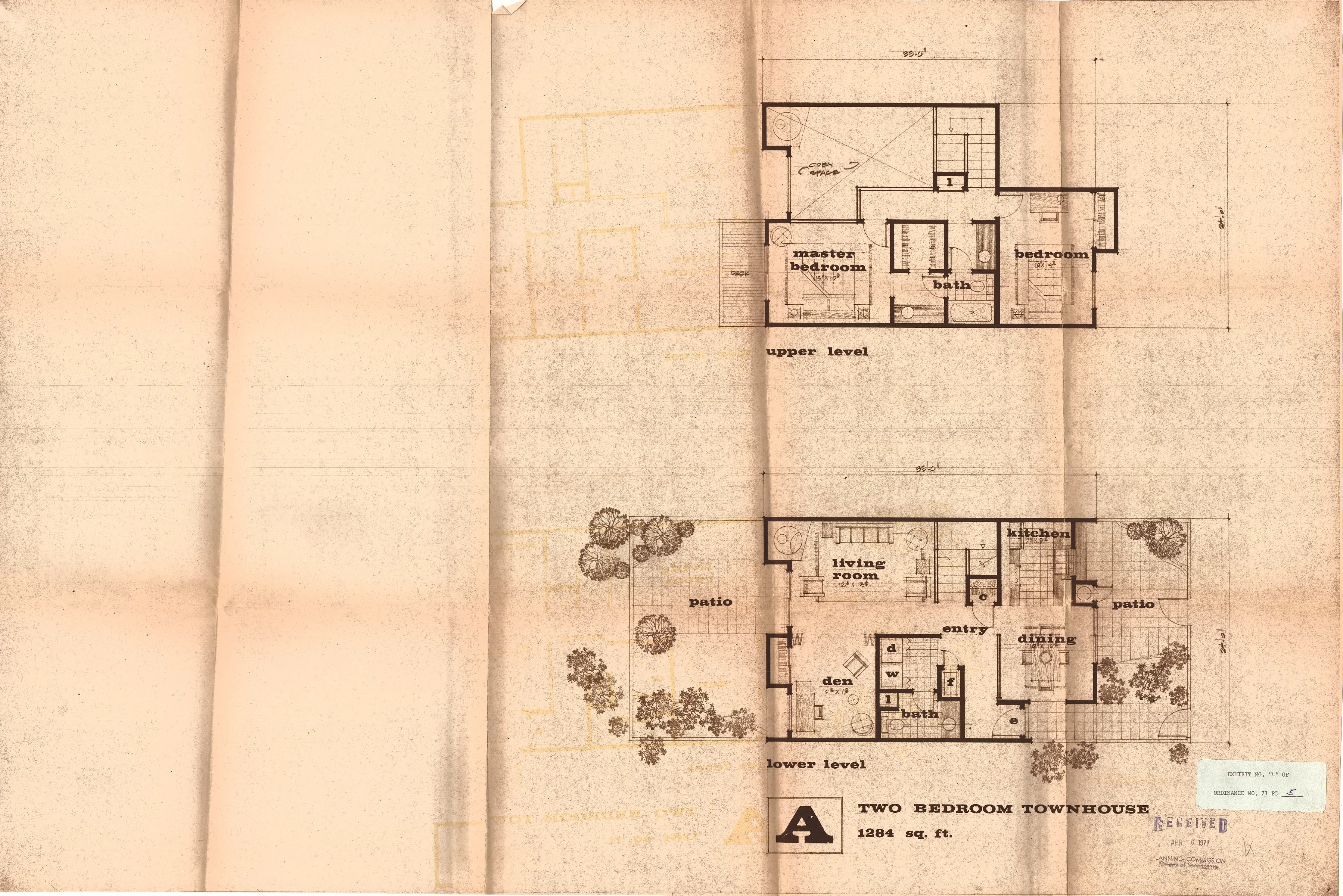
EXHIBIT 5
Section titled “EXHIBIT 5”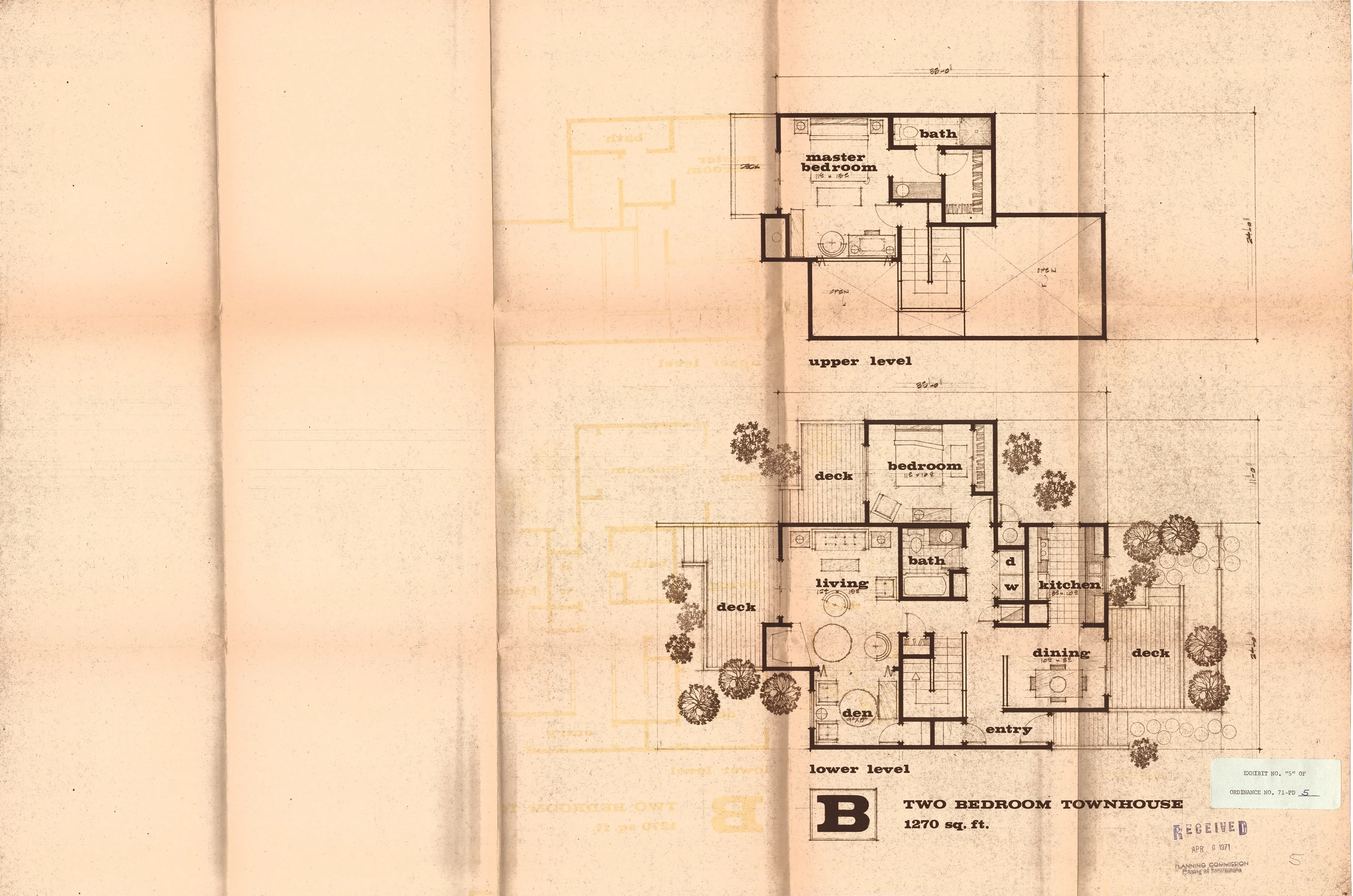
EXHIBIT 6
Section titled “EXHIBIT 6”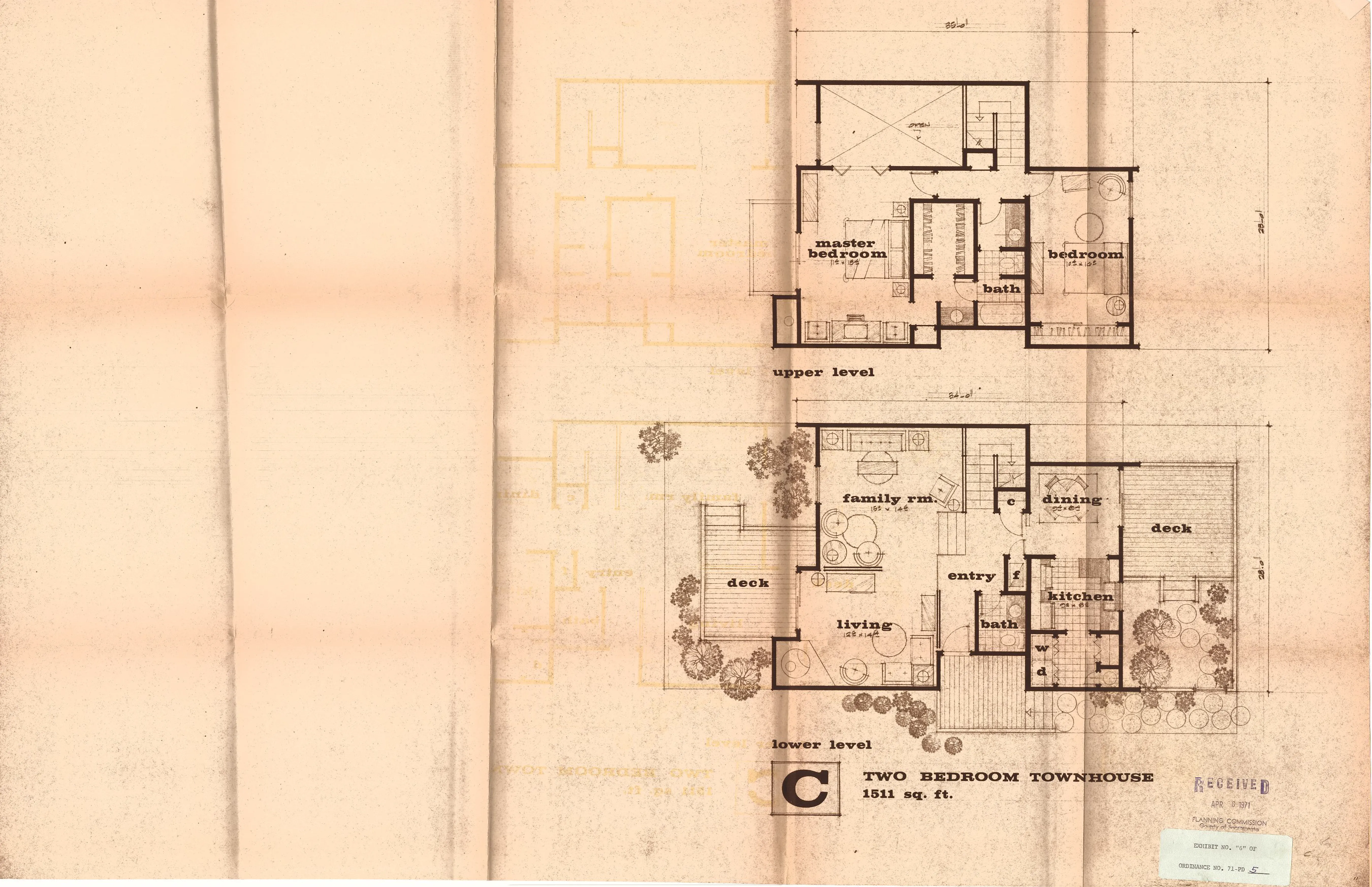
EXHIBIT 7
Section titled “EXHIBIT 7”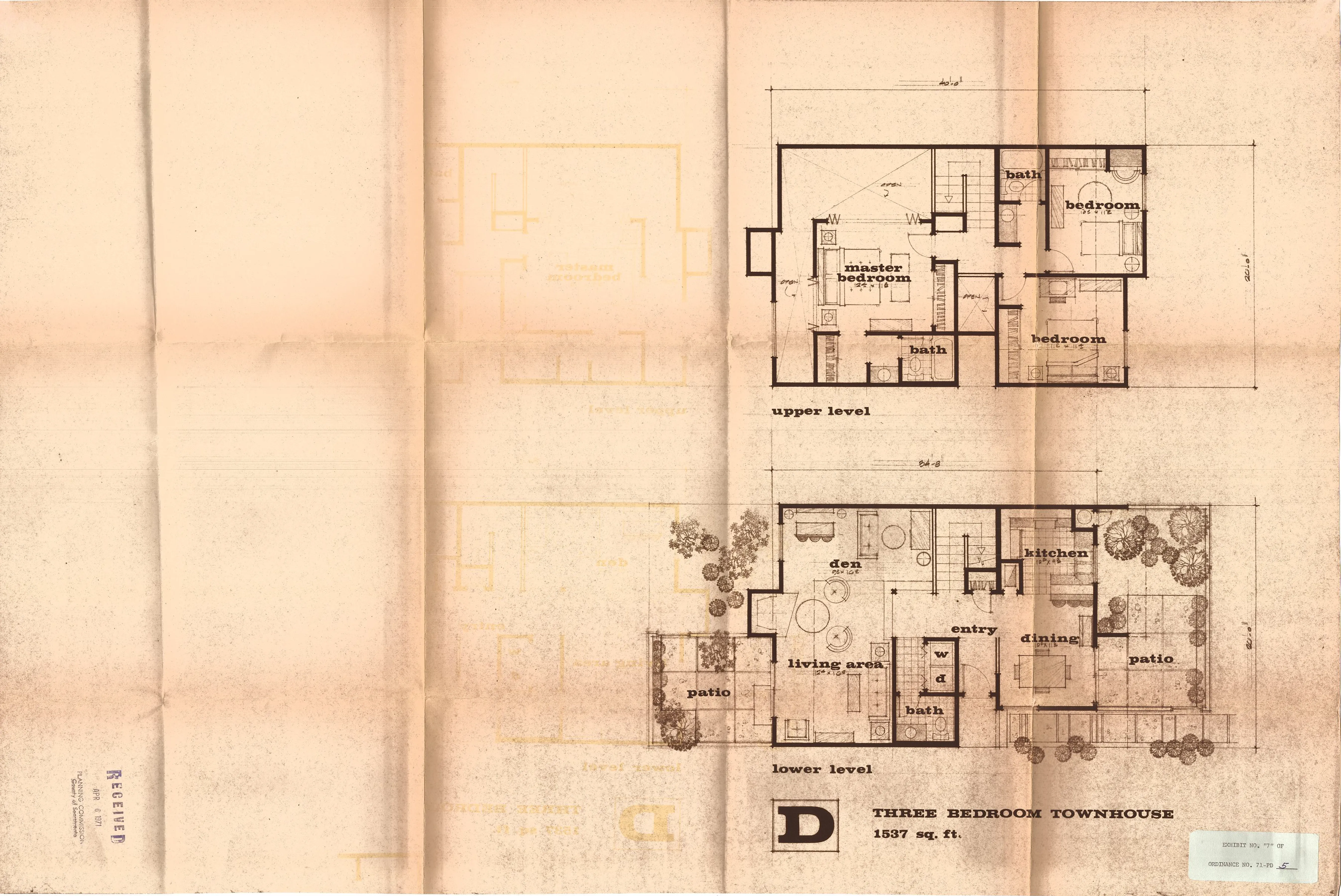
EXHIBIT 8
Section titled “EXHIBIT 8”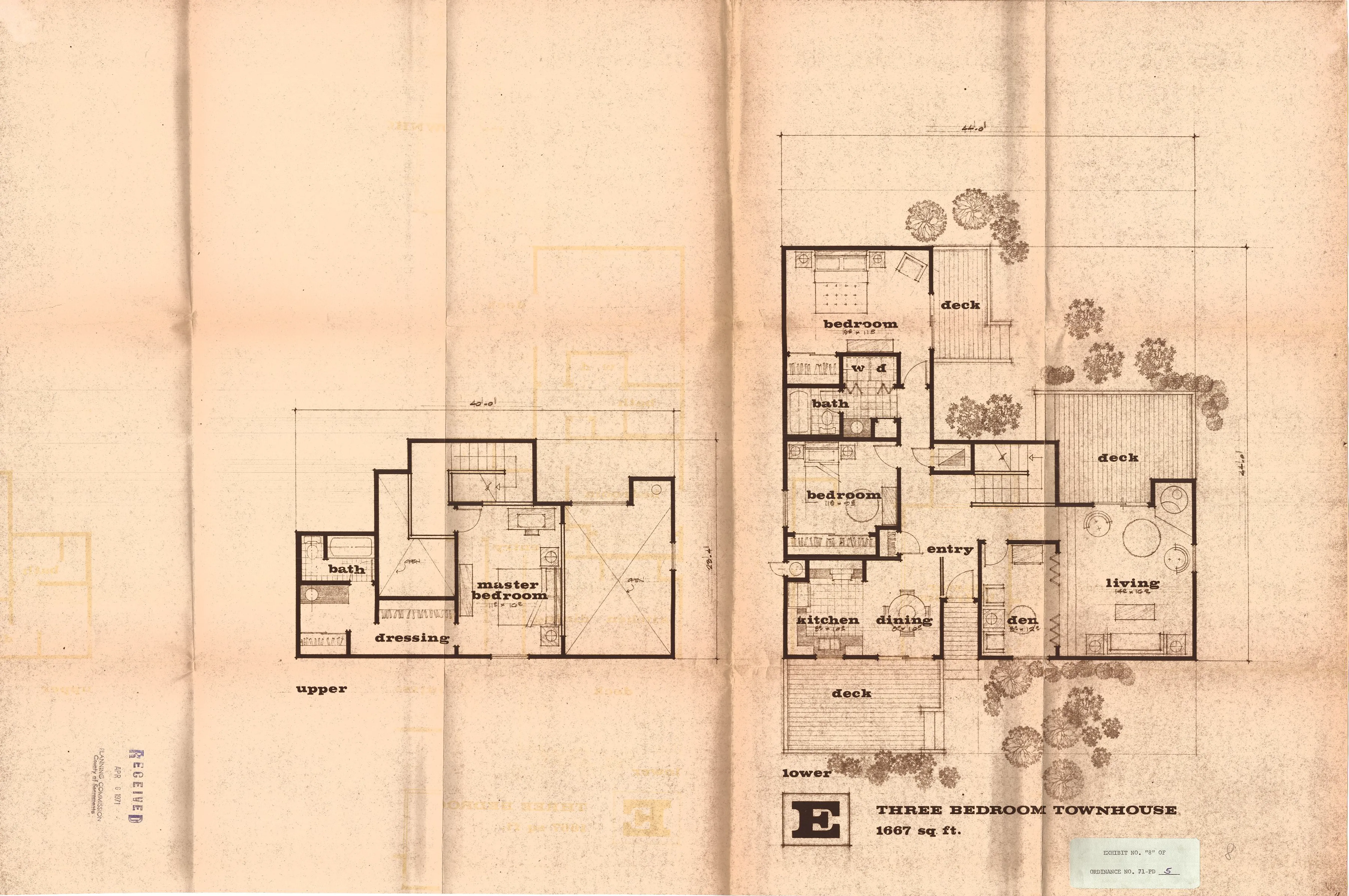
EXHIBIT 9
Section titled “EXHIBIT 9”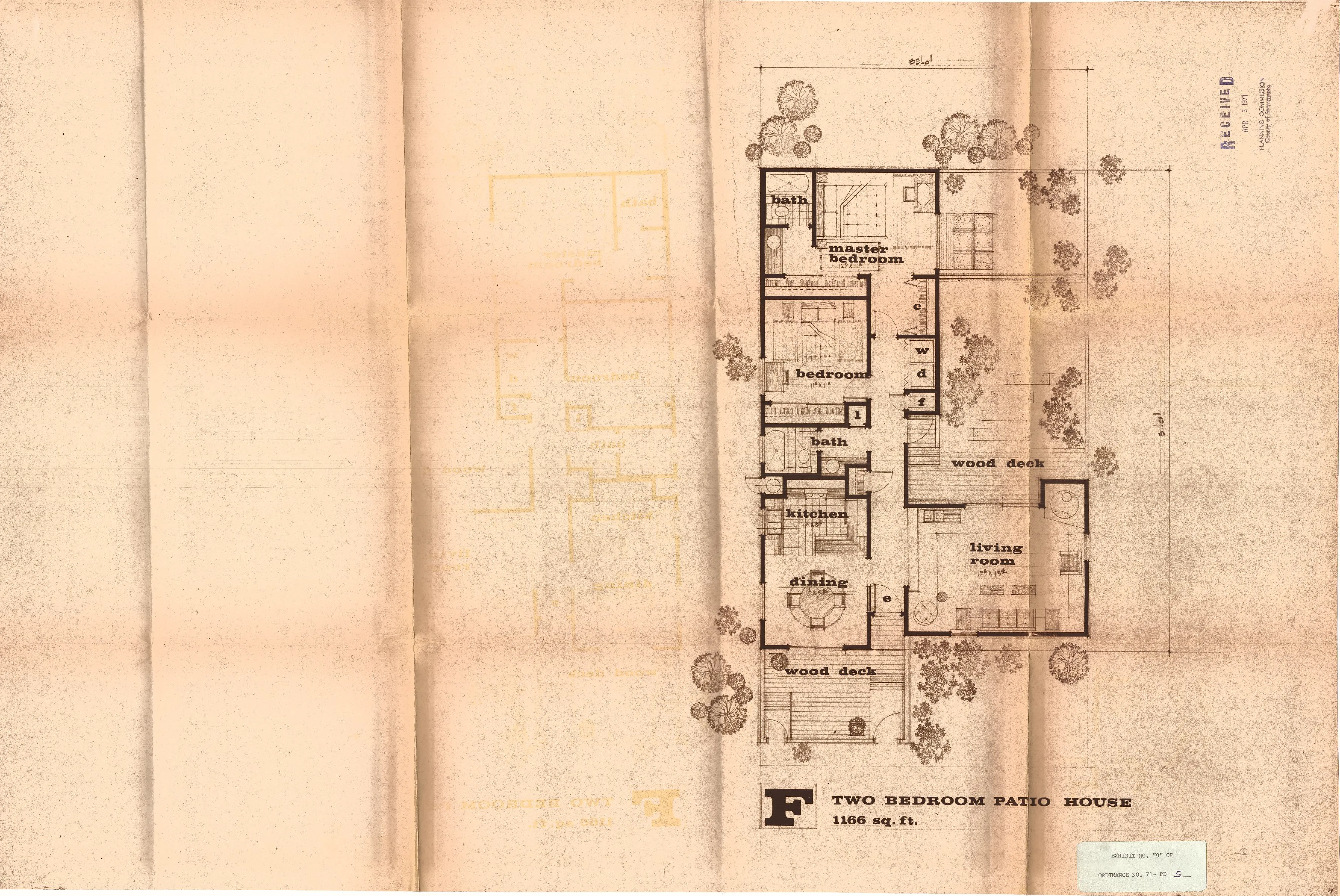
EXHIBIT 10
Section titled “EXHIBIT 10”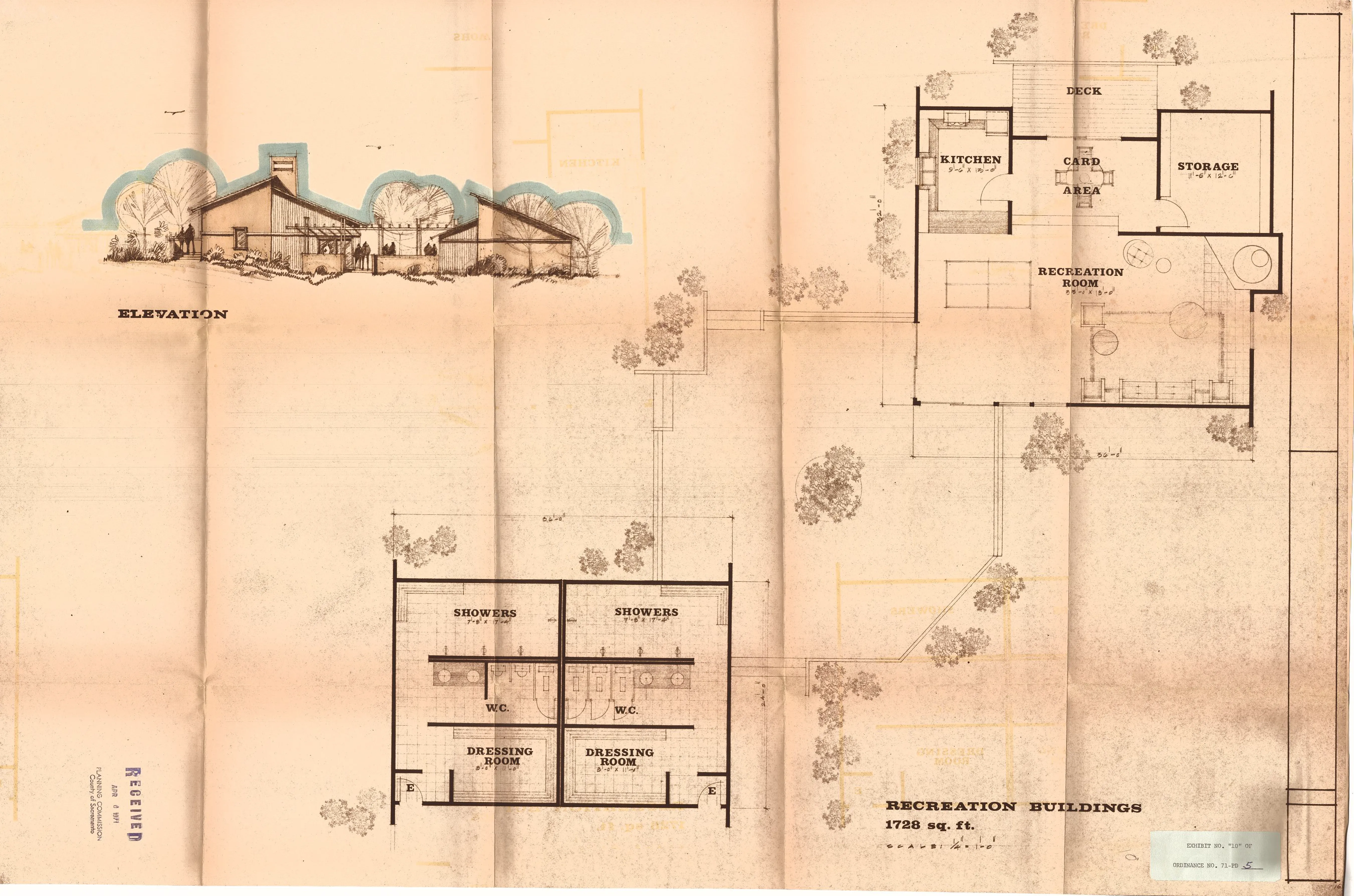
EXHIBIT 11
Section titled “EXHIBIT 11”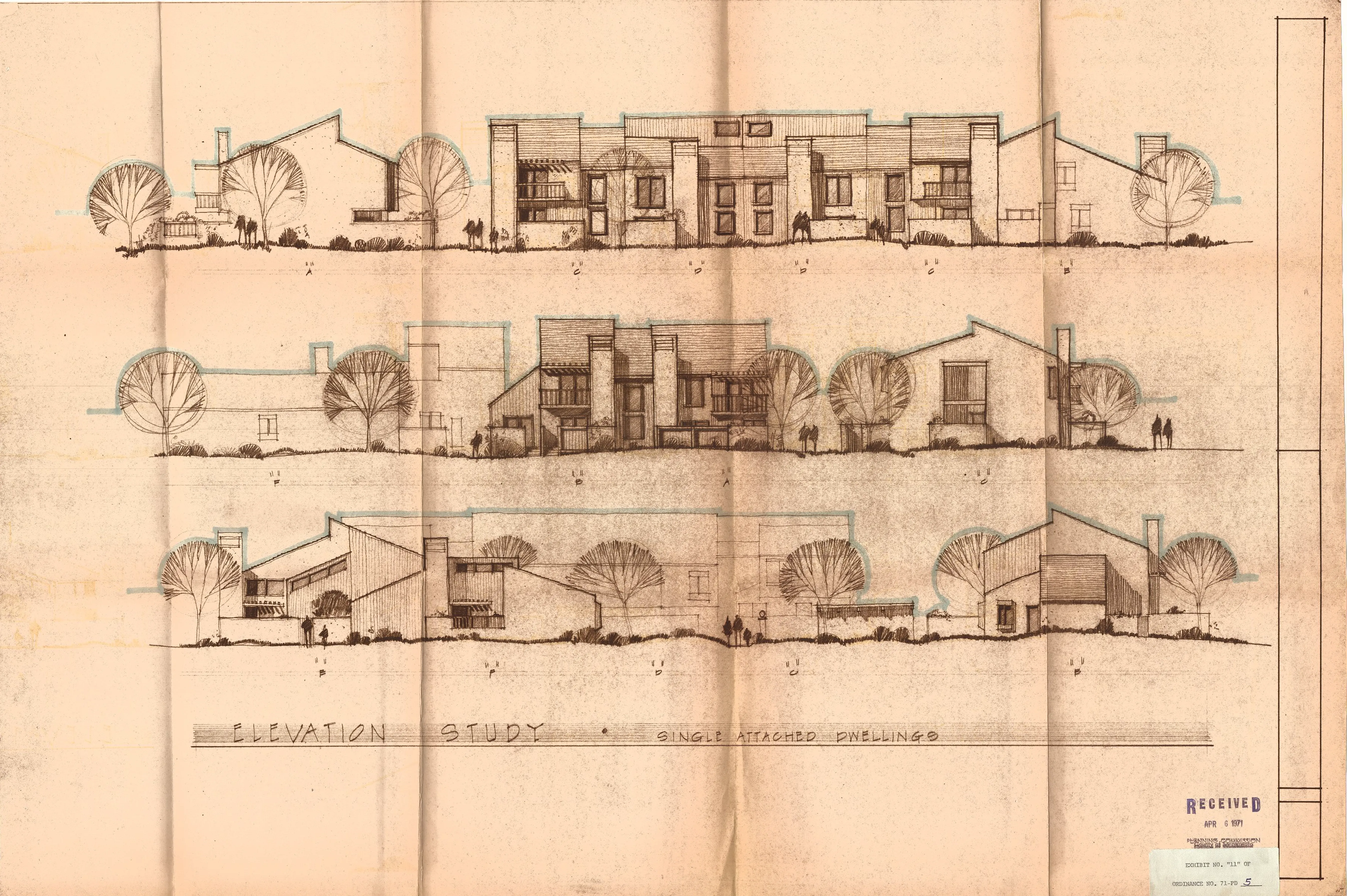
EXHIBIT 12A
Section titled “EXHIBIT 12A”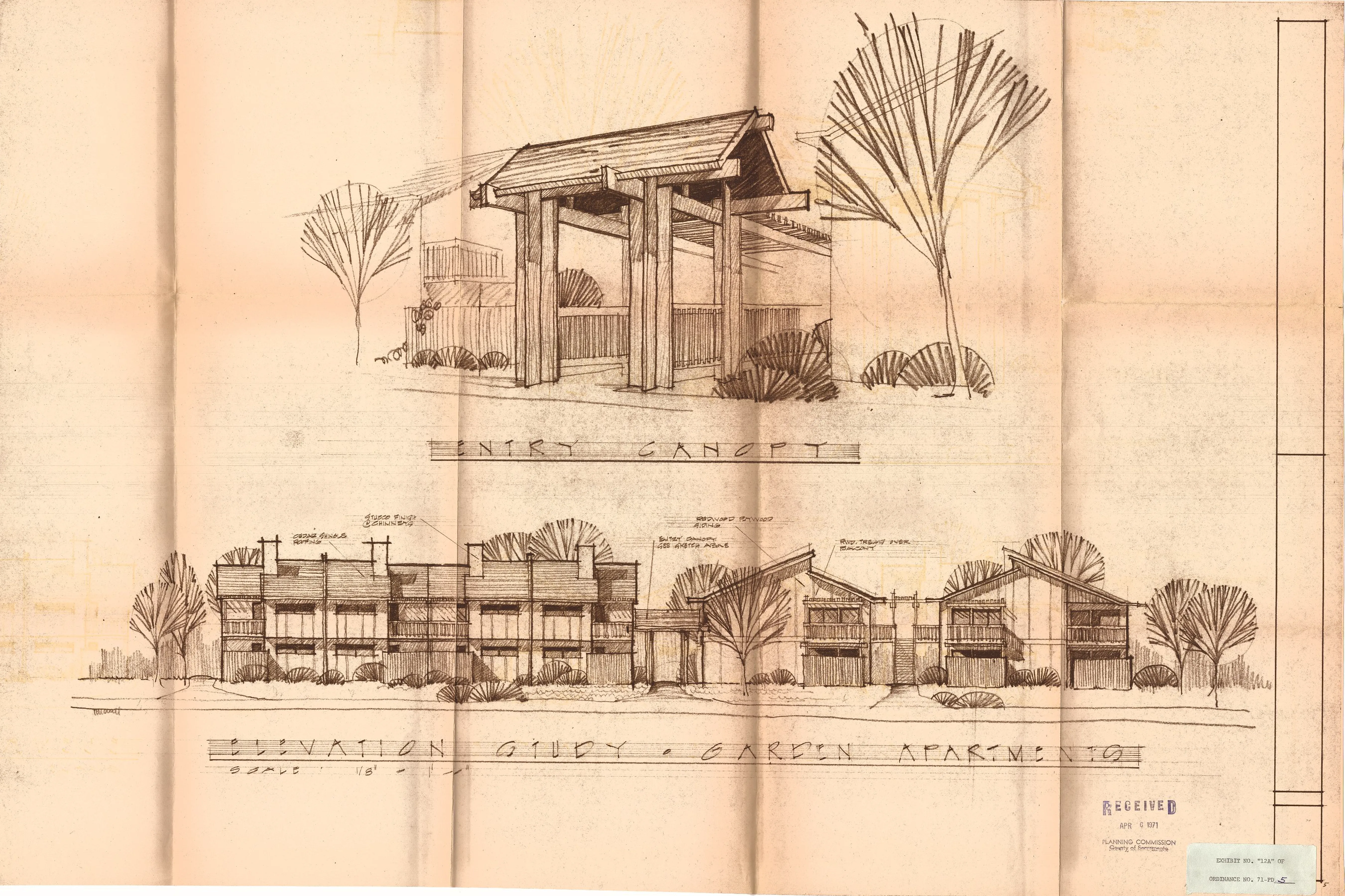
EXHIBIT 12B
Section titled “EXHIBIT 12B”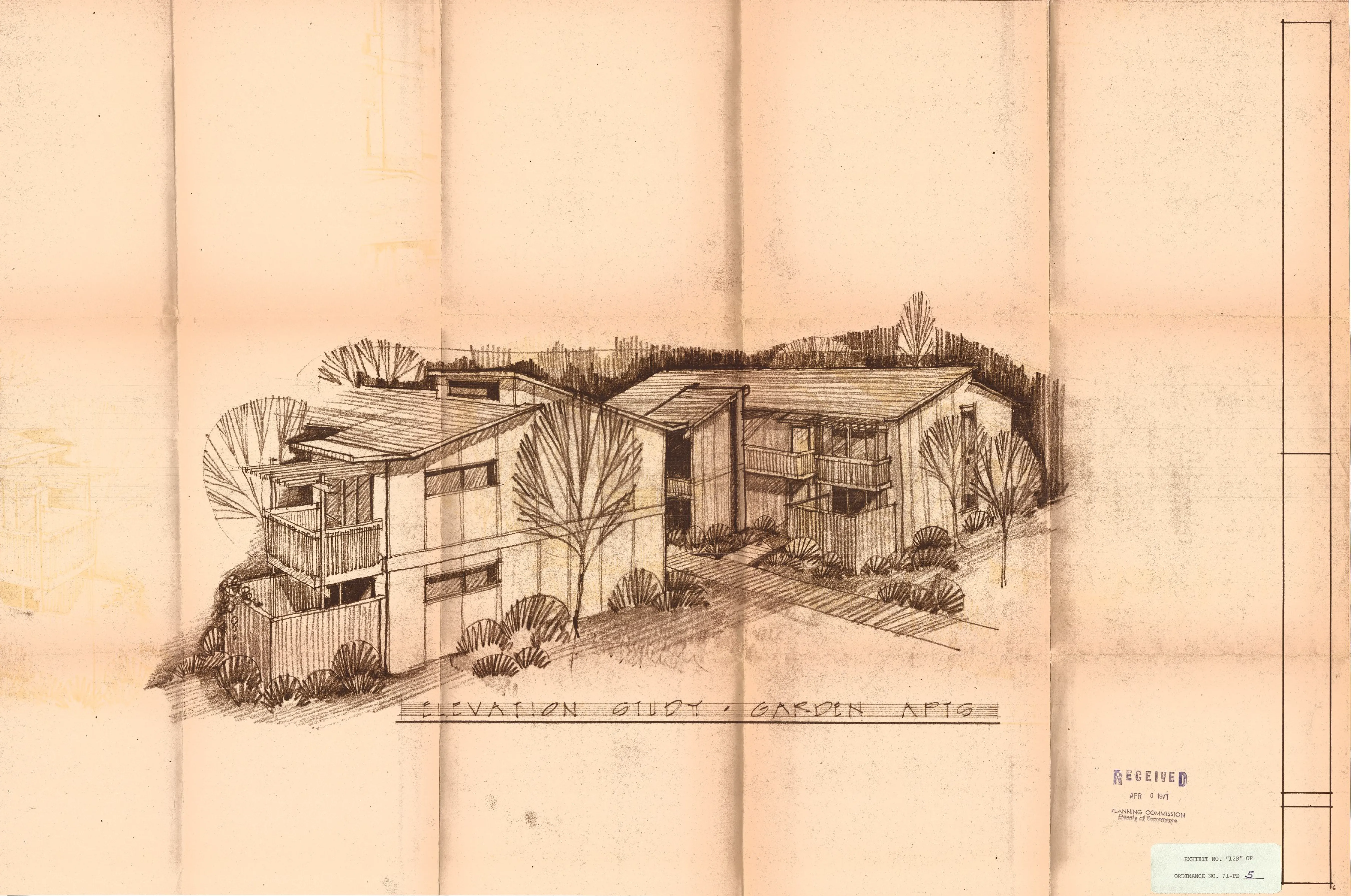
EXHIBIT 13A
Section titled “EXHIBIT 13A”[ADDED 10-29-1975]
Supersedes Exhibit 13
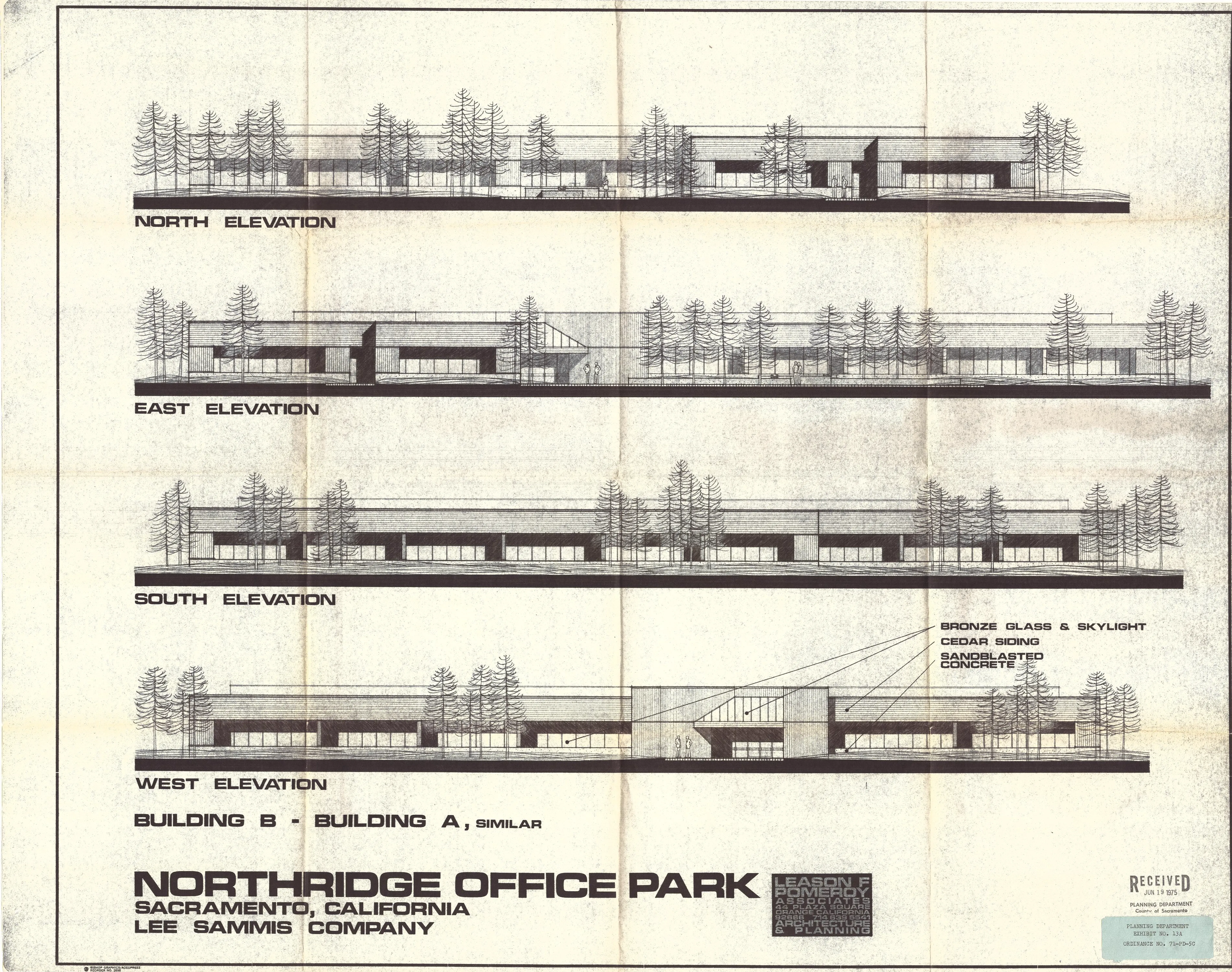
EXHIBIT 13B
Section titled “EXHIBIT 13B”[ADDED 10-29-1975]
Supersedes Exhibit 13
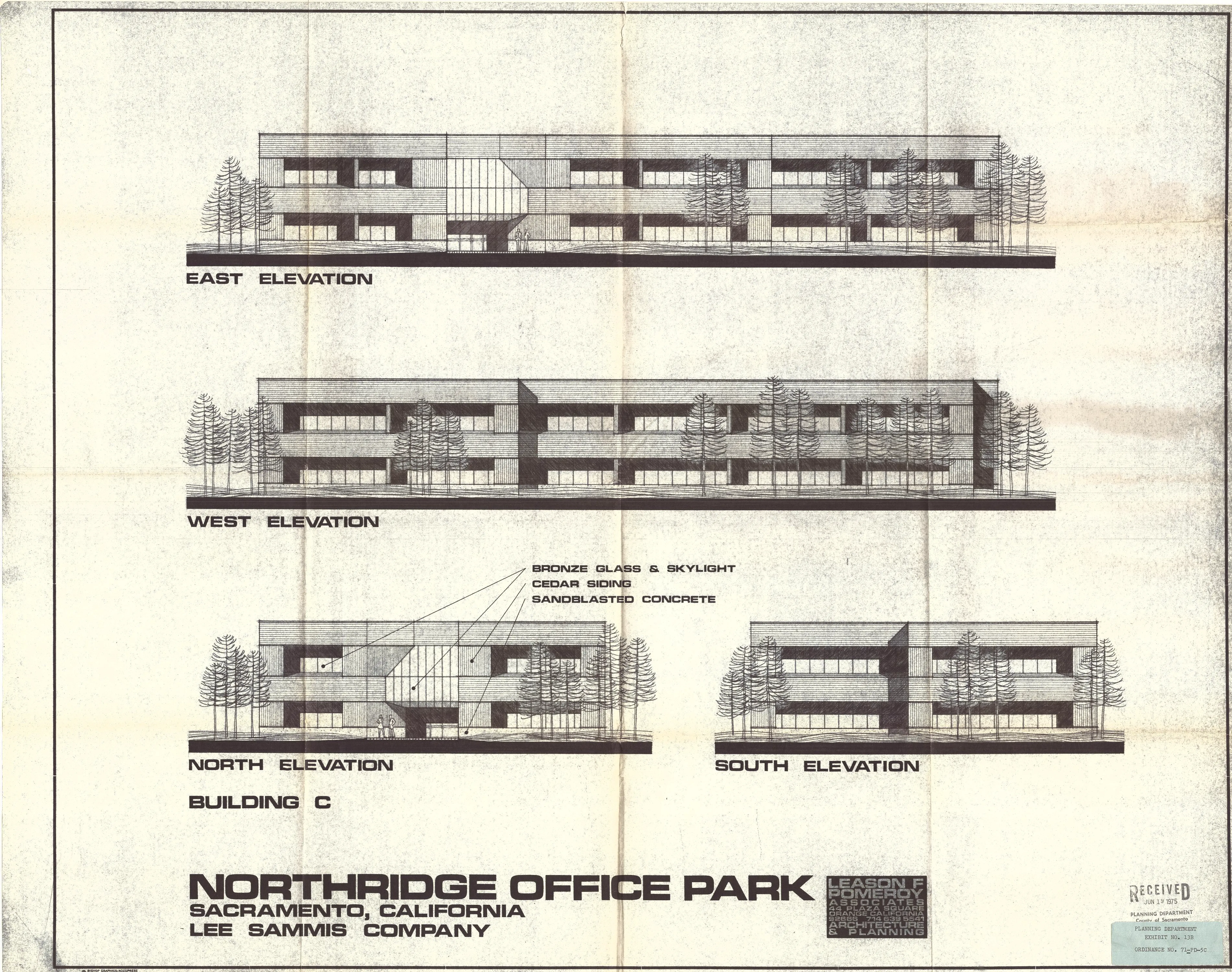
EXHIBIT 14
Section titled “EXHIBIT 14”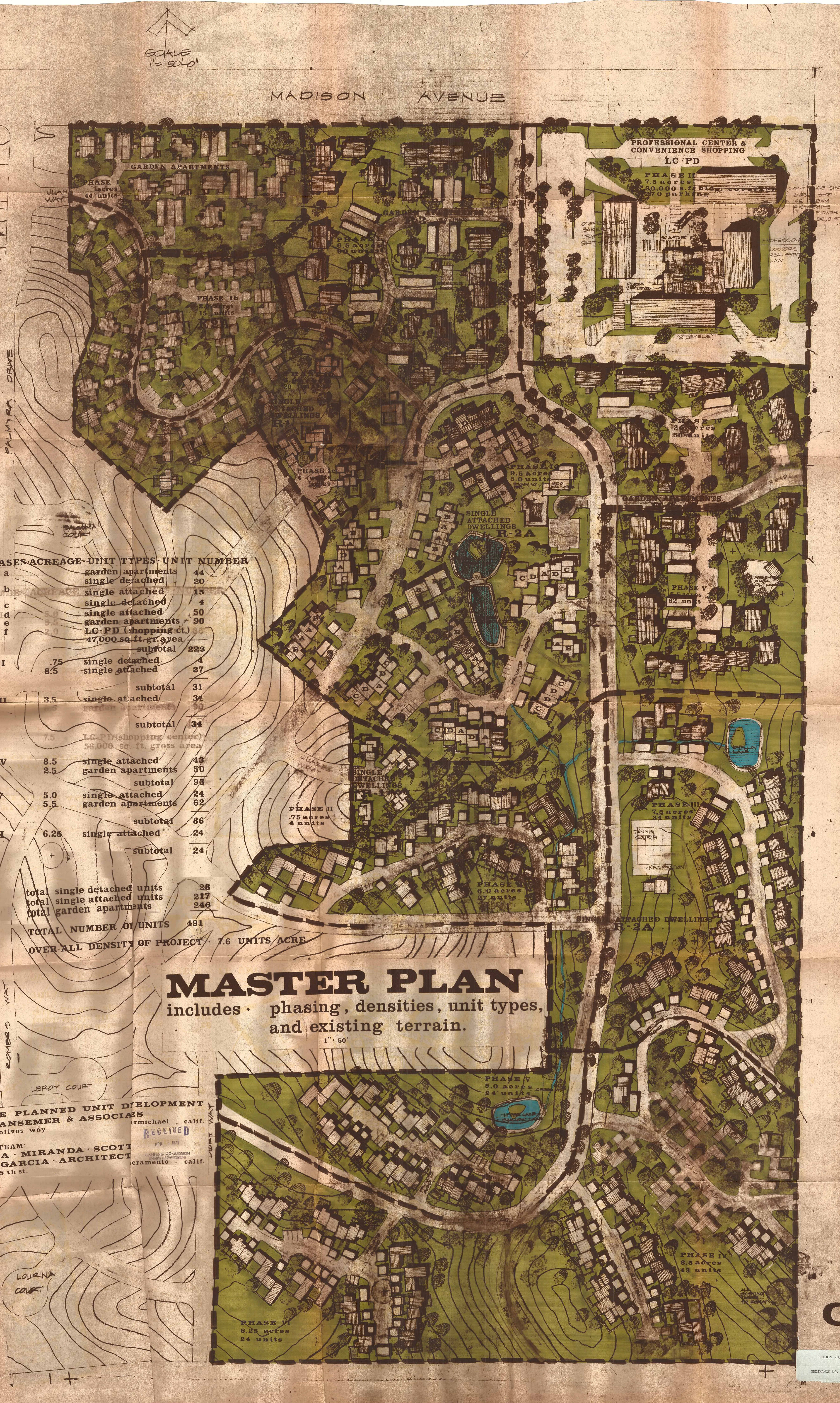
EXHIBIT 15
Section titled “EXHIBIT 15”[ADDED 08-14-1974]
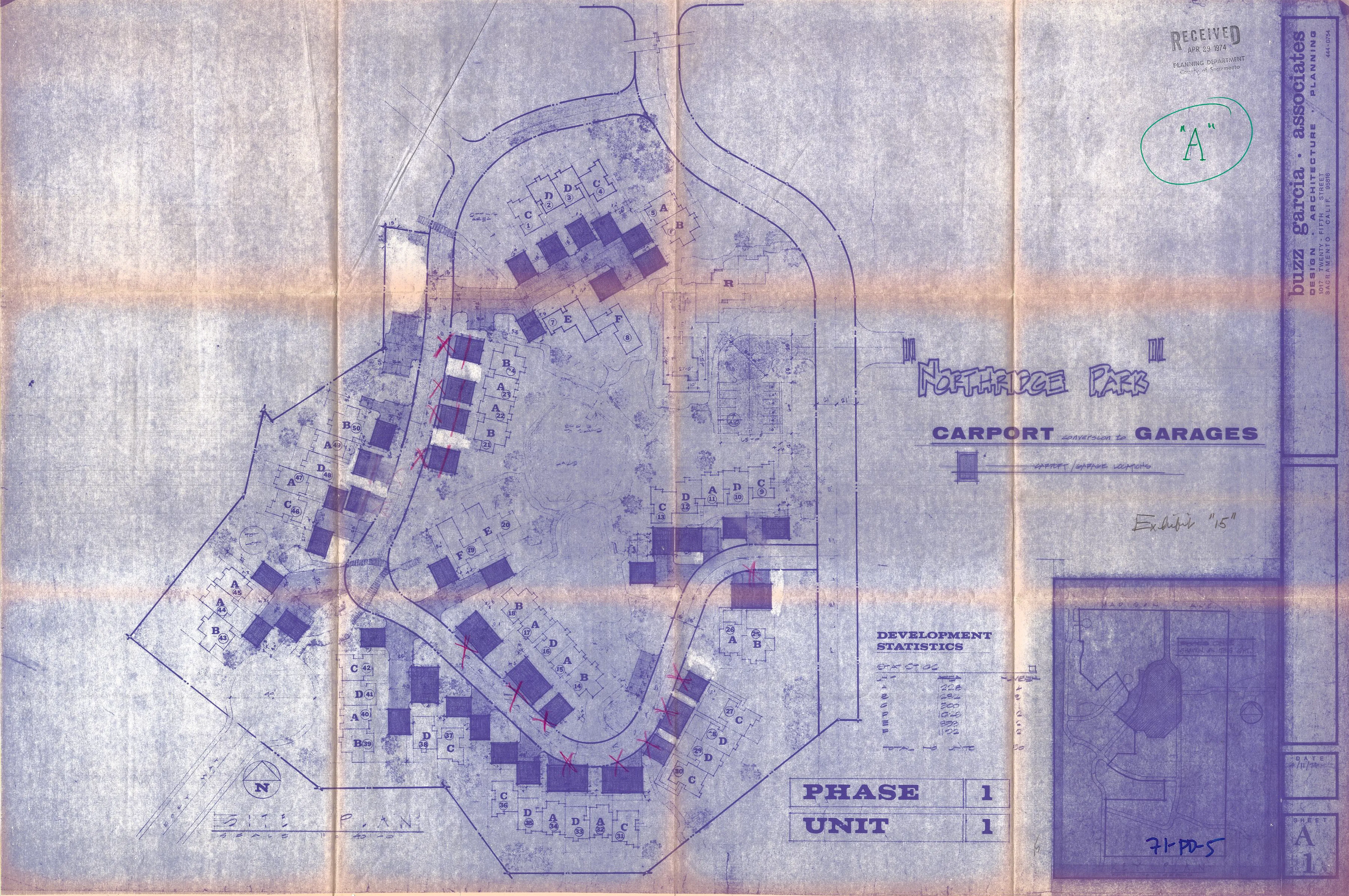
EXHIBIT 16
Section titled “EXHIBIT 16”[ADDED 08-14-1974]
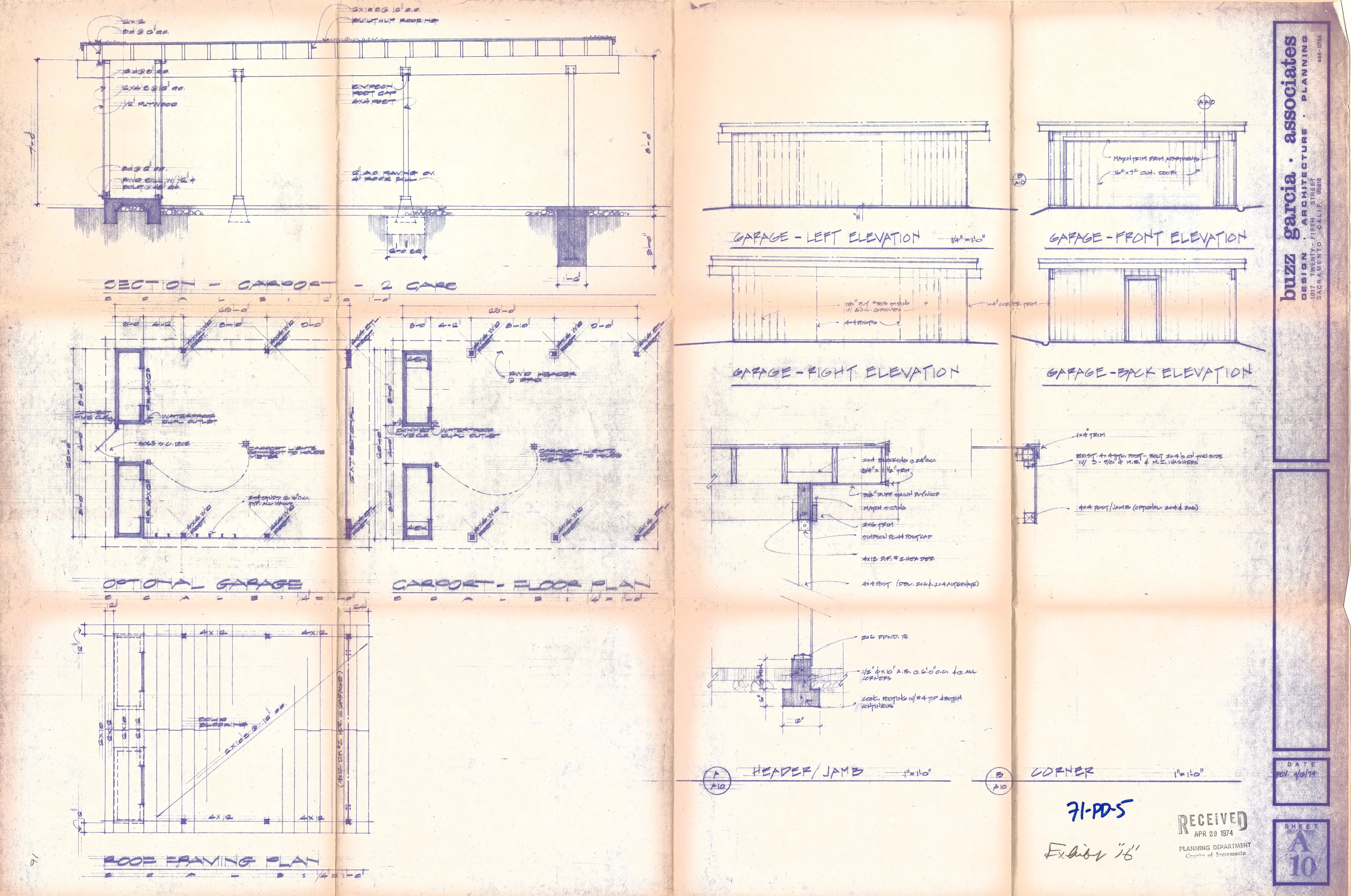
EXHIBIT 17A
Section titled “EXHIBIT 17A”[ADDED 10-29-1975]
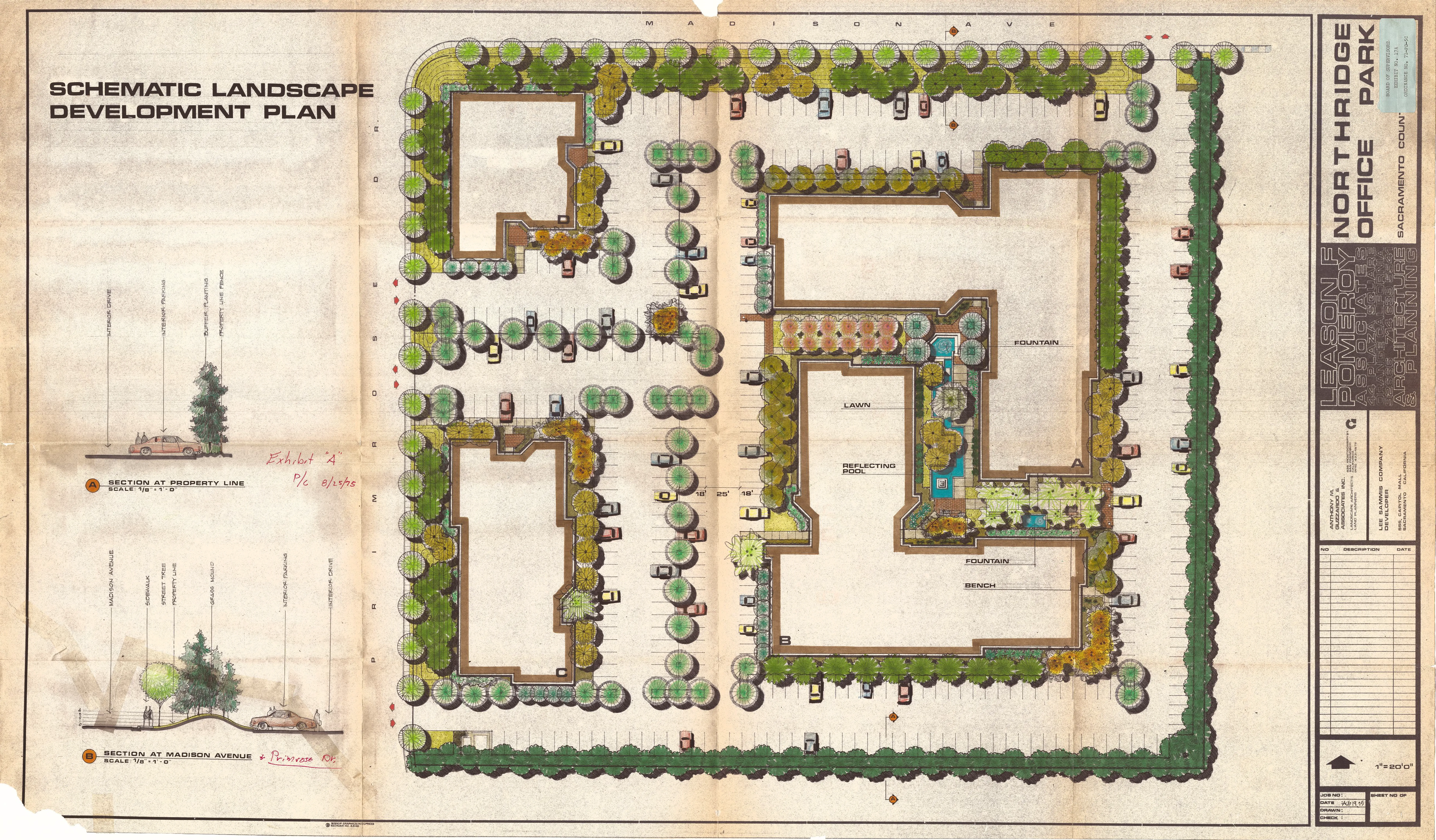
EXHIBIT 17B
Section titled “EXHIBIT 17B”[ADDED 10-29-1975]
LAKE KNOLLS APARTMENTS — PARCEL “G”
Section titled “LAKE KNOLLS APARTMENTS — PARCEL “G””Ordinance No. 71-PD-5D removed the area described in Exhibit “G” from the regulation of the base ordinance (71-PD-5) and established a separate planned unit development, commonly known as Lake Knolls Apartments. The area is governed by its own Sections 1 through 14 and Exhibits 18 through 21, as set forth below.
Adopted July 14, 1976
71-PD-5D
Amends the Zoning Code of Sacramento County, Ordinance No. 1111
SECTION 1. PROPERTY REZONED
Section titled “SECTION 1. PROPERTY REZONED”Section 1 of Ordinance No. 71-PD-5, as amended, is amended to change the regulation of the real property described in Exhibit “G”, attached hereto and incorporated herein and made a part of this Ordinance, from the provisions of the base Ordinance to the provisions set forth in this part.
SECTION 2. INCORPORATION WITHIN THE ZONING CODE
Section titled “SECTION 2. INCORPORATION WITHIN THE ZONING CODE”Section 23.01.315 of the Zoning Code of Sacramento County, Ordinance No. 1111, as amended, is amended to read as follows:
Section 23.01.315. Planned Unit Development Ordinance 71-PD-5 as amended by Ordinance No. 71-PD-5A, Ordinance No. 71-PD-5B, Ordinance No. 71-PD-5C, and Ordinance No. 71-PD-5D.
SECTION 3.
Section titled “SECTION 3.”Exhibits 18 through 21, inclusive, described generally in this section and attached to this Ordinance are incorporated herein and made a part of this Ordinance to regulate the property described in Exhibit “G”. The Exhibits are on file in the office of the Clerk of the Board of Supervisors and are a part of this ordinance as if fully set forth herein.
Exhibits:
- 18 - Site Plan
- 19 - Floor Plans
- 20 - Elevations
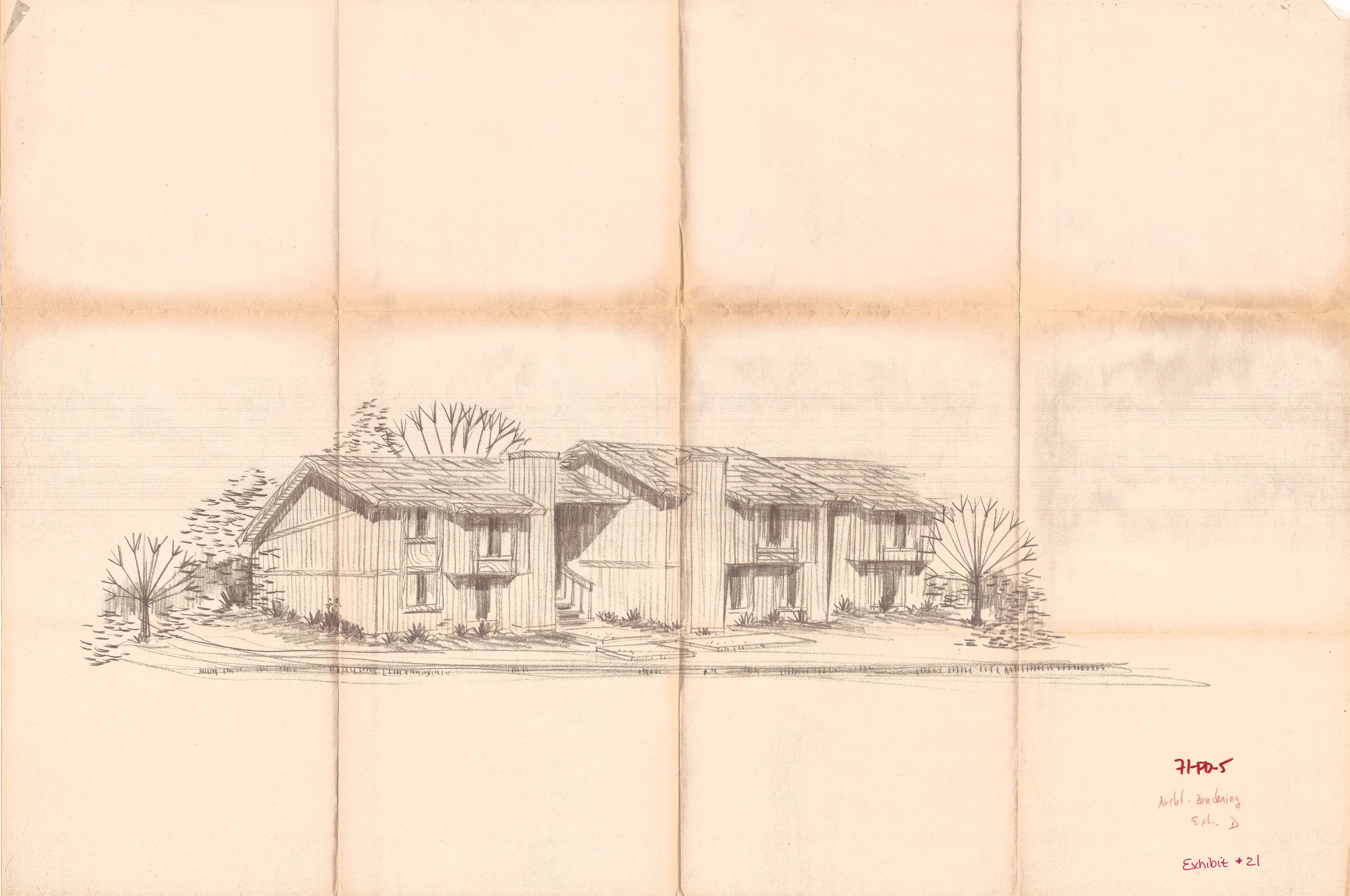
- 21 - Architectural Rendering
SECTION 4. PERMITTED USES
Section titled “SECTION 4. PERMITTED USES”All uses are authorized on the property described in Exhibit “G” which are authorized in the R-2-A Zone with which the Planned Development zone is combined.
SECTION 5. CONFIGURATION OF PROJECT
Section titled “SECTION 5. CONFIGURATION OF PROJECT”The location, configuration, and arrangement of the buildings, driveways, parking facilities, landscaping and recreational facilities shall be as shown on Exhibit 18.
The Board of Supervisors recognizes that in construction of the project minor deviations from the location and configuration of the project as shown on Exhibit 18 may occur. The Board having considered this possibility has determined that such insubstantial deviations do not constitute an amendment to the plan and delegates to the Planning Director the authority to approve any such changes.
The Board further has determined that variations from the location and configuration of the project of up to five (5) feet in any direction from the location as shown on Exhibit 18 is not a substantial deviation, provided however, that the setback from the perimeter of the property for any structure shall not be less than twenty-five (25) feet, nor that dimensions indicated on Exhibit 18 as minimum shall not be less than the amount shown.
SECTION 6. STREETS
Section titled “SECTION 6. STREETS”The perimeter streets adjoining the project as shown on Exhibit 18, shall be offered for dedication as a public street with a right-of-way as shown thereon, and shall be constructed in accordance with County Improvement Standards, adopted by Resolution No. 73-495, of the Board of Supervisors of the County of Sacramento for Class “A” Streets. All private roads are to be named and dwelling units are to be identified by signs showing the unit numbers and such names at locations readily visible to emergency vehicles. Such private roads and driveways shall be as provided in Section 9.03-9.01 of the County Improvement Standards adopted by Resolution No. 73-495 of the Board of Supervisors of the County of Sacramento, and amendments thereto which establish the allowable thickness for 42 foot wide streets. At the intersection of any private roads with any public street, the width of the private road at the right of way line of the public street shall not be less than 35 feet.
The location and configuration of the parking areas shall be as shown on Exhibit 18 except that the dimensions of the parking stalls shall conform to the parking standards set forth in Chapter 15 of the Zoning Code of the County of Sacramento, Ordinance No. 1111.
SECTION 7. LANDSCAPING
Section titled “SECTION 7. LANDSCAPING”Landscaping plans shall be submitted to the Project Planning Commission. No building permits shall be issued for any buildings within the project until landscaping plans for the development are approved by said Commission. Such plans shall provide for visual screening from adjacent property, and shall consist of live growing shrubs and trees, irrigated with a permanently installed system. Said trees when planted shall not be less than five (5) gallon size, and shall be placed no further apart than twenty (20) feet on center. The peripheral landscaping, providing visual screening from adjacent property, shall be installed before the completion of any buildings within the property.
SECTION 8. DWELLING UNITS
Section titled “SECTION 8. DWELLING UNITS”The dwelling units constructed within the property described in Exhibit “G” shall substantially conform to the floor plans shown on Exhibit 19, and to the elevations and architectural rendering on Exhibits 20 and 21. It is the intent of the Board of Supervisors to permit the developer to construct any combination of the several floor plans and elevations shown in Exhibits 19 and 20, within any of the clusters of dwelling units indicated on Exhibit 18; provided however, that:
- The number of dwelling units shall not exceed 136 units.
- The configuration of dwelling unit clusters shall conform to, and the number shall not exceed but may be less than, as shown on Exhibit 18.
- The number of dwelling units within each cluster shall not exceed but may be less than the number of dwelling units shown on Exhibit 18, taking into consideration that each dwelling unit shown on Exhibit 18 may be two-story, with one unit below and one unit above.
SECTION 9. RECREATION FACILITIES
Section titled “SECTION 9. RECREATION FACILITIES”The location and configuration of the recreation facilities shall be as shown on Exhibit 18 and shall be constructed concurrently with the dwelling units of the project. No occupancy permit shall be issued for any dwelling unit until the recreation facilities are completed.
Any lighting of the tennis courts shall be arranged so that the emitter or source of any outdoor lighting shall not be directly observable at the property line of adjoining residential uses, above a plane located four (4) feet above the ground surface. Hours of operation for the tennis courts shall be established and maintained so that all playing ceases at 10:00 P.M. on Sunday through Thursday nights and no later than 11:00 P.M. on Friday and Saturday nights. No out-of-doors sound amplification facilities shall be installed or utilized in any of the recreation areas.
SECTION 10. PHASING
Section titled “SECTION 10. PHASING”Construction of the project shall begin no later than twelve months from the effective date of this ordinance, and shall be completed not later than thirty (30) months from the effective date of this ordinance.
SECTION 11. FINDINGS
Section titled “SECTION 11. FINDINGS”During the public hearings on this Ordinance the Planning Commission and the Board of Supervisors determined that:
- The proposed development will carry out the intent of the General Plan.
- The proposed development is of sufficient size and is designed so as to provide a desirable environment within its own boundaries.
- The proposed development is compatible with existing and proposed land uses in the surrounding area.
- Exceptions to the standard requirements of the Sacramento County Zoning Code, Ordinance No. 1111, as amended, are justified by the design of the development.
- The arrangements of dwellings and mixing of dwelling types is justified by larger and more usable open spaces.
- There is adequate assurance that all public improvements will be installed at the scheduled times as required by the Public Works Department.
- There is adequate assurance that the development schedule will be met.
- The existing or proposed utility services are adequate for the uses and population densities proposed.
SECTION 12. VARIANCES
Section titled “SECTION 12. VARIANCES”The variance provisions of Article 1, Chapter 18, of the Sacramento County Zoning Code, Ordinance No. 1111, as amended, shall not apply to this Ordinance.
SECTION 13. VIOLATIONS
Section titled “SECTION 13. VIOLATIONS”Violation of the provisions of this Ordinance shall be deemed a violation of the Sacramento County Zoning Code, Ordinance No. 1111, as amended.
SECTION 14. EFFECTIVE DATE
Section titled “SECTION 14. EFFECTIVE DATE”This ordinance shall take effect and be in full force on and after thirty (30) days from the date of its passage hereof, and before the expiration of fifteen (15) days from the date of its passage it shall be published once with the names of the members of the Board of Supervisors voting for and against the same, said publication to be made in a newspaper of general circulation published in the County of Sacramento.
PASSED AND ADOPTED by the Board of Supervisors of the County of Sacramento, State of California, this 14th day of July, 1976, by the following vote, to wit:
- AYES: Supervisors, KLOSS, WADE, MELARKEY
- NOES: Supervisors, SMOLEY
- ABSENT: Supervisors, SHEEDY
Chairman of the Board of Supervisors of Sacramento County, California
(SEAL)
ATTEST: Clerk of the Board of Supervisors
Publish in the Press-Journal 7/29/76. Send one affidavit and two publication bills with notice attached to each.
EXHIBIT “G”
Section titled “EXHIBIT “G””All of Parcels “A” and “B” as recorded in the Office of the Recorder of Sacramento County in Parcel Book 17 of Maps, Map No. 47.
EXHIBIT 18
Section titled “EXHIBIT 18”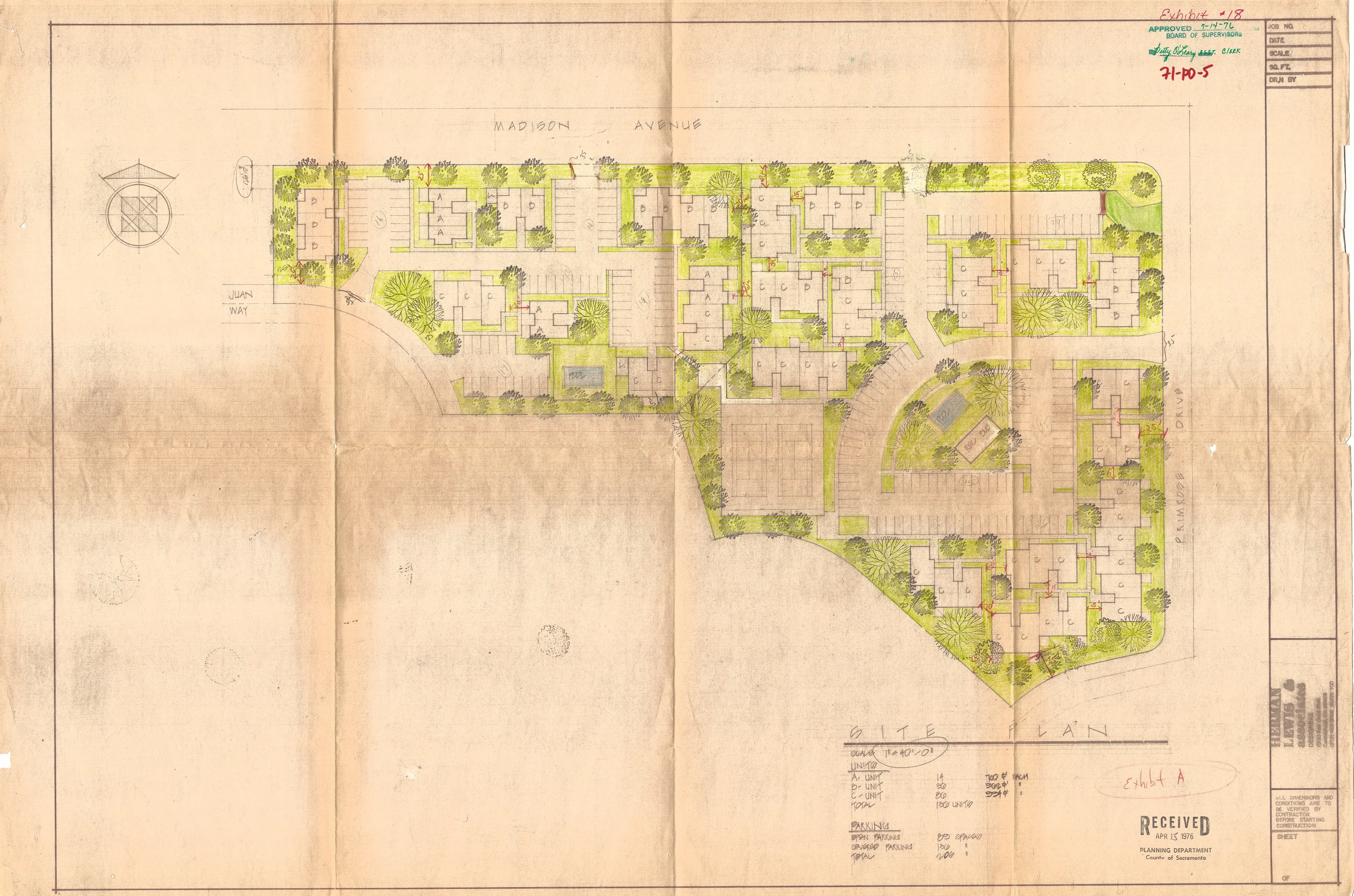
EXHIBIT 19
Section titled “EXHIBIT 19”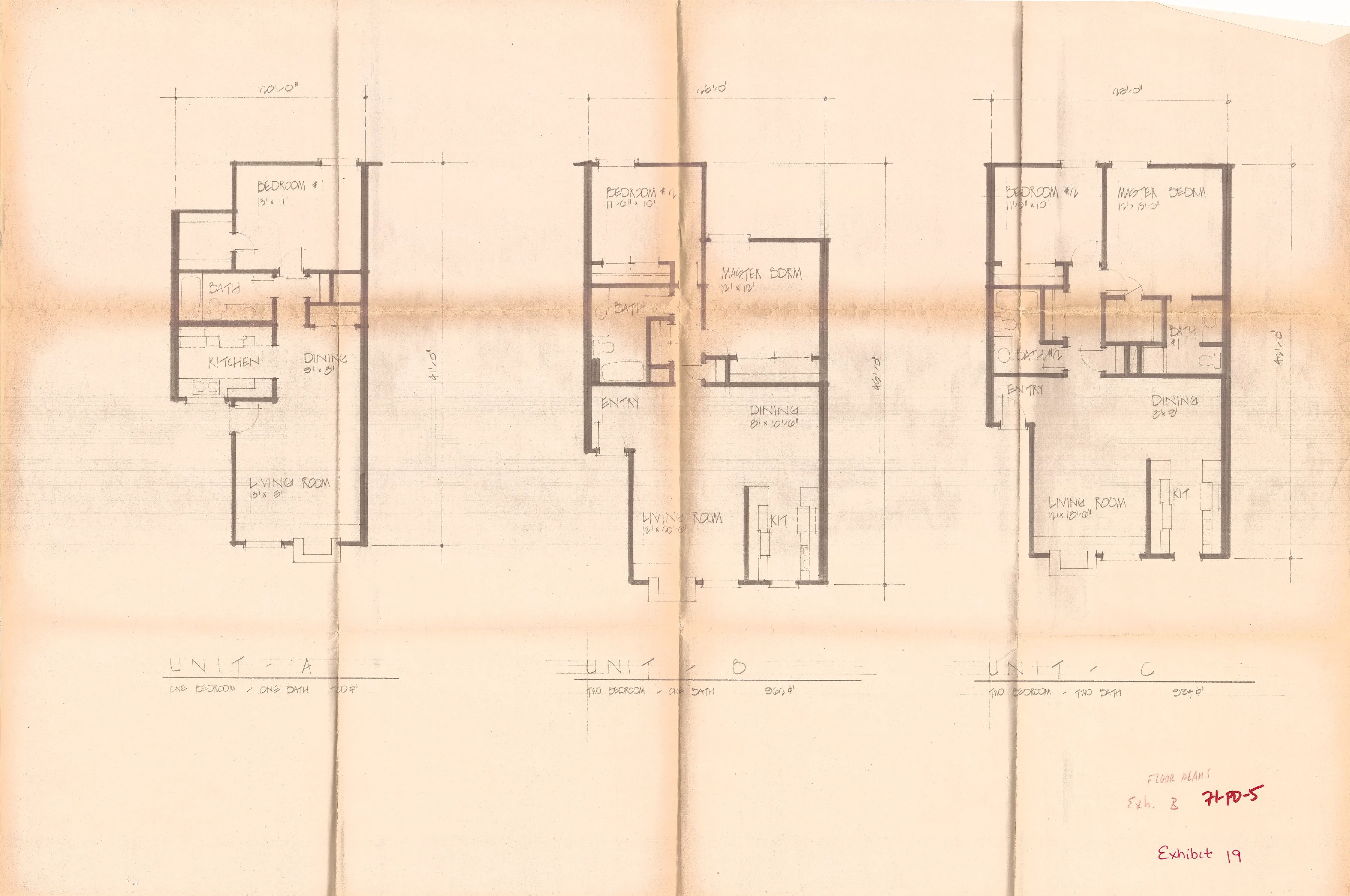
EXHIBIT 20
Section titled “EXHIBIT 20”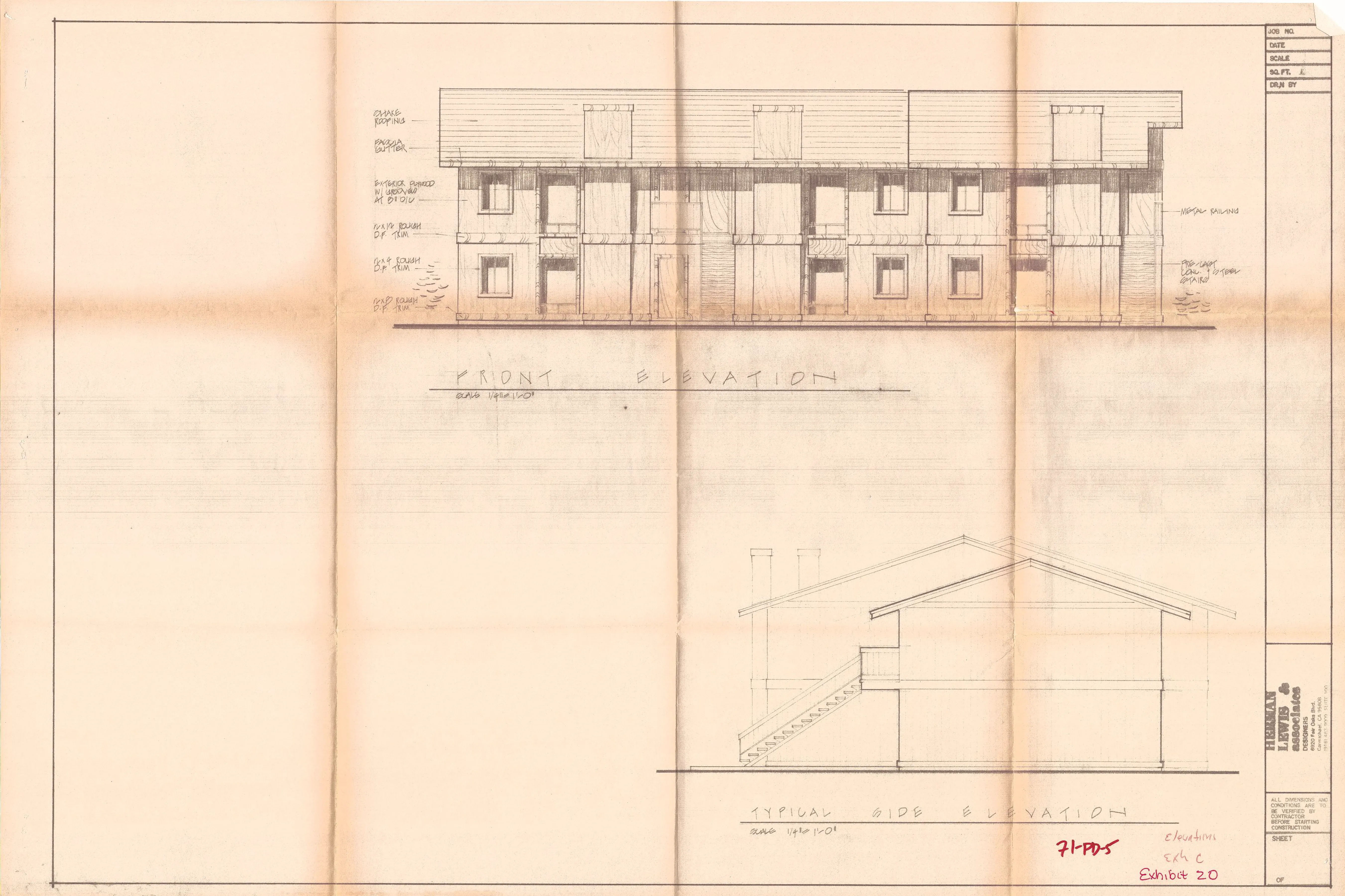
EXHIBIT 21
Section titled “EXHIBIT 21”