

Chapter 4: Land Use
South Sacramento Habitat Conservation Plan
Chapter 4: Land Use
Section titled “South Sacramento Habitat Conservation Plan Chapter 4: Land Use”4.1 Introduction
Section titled “4.1 Introduction”This chapter provides an overview of historic, existing, planned, and projected long-term land use conditions in the Plan Area. This chapter also examines forecasted demands for housing, commercial goods, and services in the Plan Area over the next 50 years.
4.2 Historical Land Use Conditions of the Plan Area
Section titled “4.2 Historical Land Use Conditions of the Plan Area”During the early part of the 20th century, agricultural and grazing lands dominated the landscape of Sacramento County, interrupted only by small pockets of urbanization. In the 1940s, Sacramento County experienced a rapid increase in population with a majority of new growth occurring within or near the City of Sacramento and in smaller cities, such as Folsom, Galt, and Isleton. A second wave of growth occurred between 1950 and 1960 when Sacramento County’s population grew by 81%, and the unincorporated county saw an expansion of urbanization to the south (Florin) and the east (Rancho Cordova). During the 1960s, 1970s, 1980s, and early 1990s, moderate but steady increases in population growth occurred along with an expansion of urban infrastructure farther into the southern and eastern portions of the county, resulting in conversion of grazing and croplands to urban uses.
In the early 1990s, a downturn in the housing market precipitated a sharp decrease in home sales, and a slowdown in urban expansion ensued. However, during the first 5 years of the 21st century, the entire region experienced explosive housing production and unprecedented urban sprawl as long-term interest rates reached historical lows, and jurisdictions struggled to keep up with housing demand. The housing market slowed and then softened considerably from 2007 to 2009 due to market contraction and asset value decline. Development slowed and home values dropped as housing supply exceeded demand for the first time in approximately 4 or 5 years.
4.3 Existing and Planned Land Use by Jurisdiction
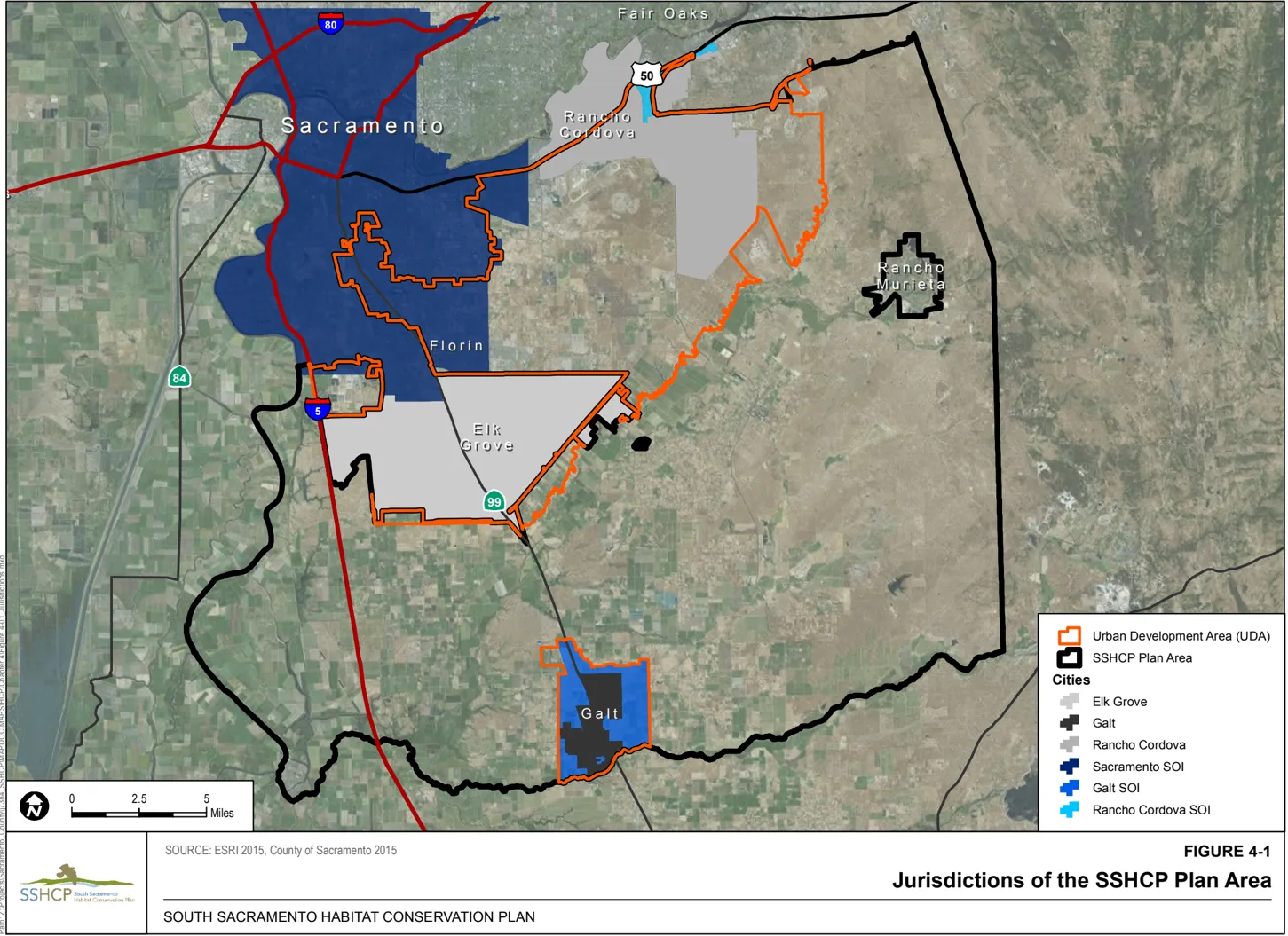
Section titled “4.3 Existing and Planned Land Use by Jurisdiction”The following section describes existing and planned land uses and General Plan policies related to the protection of natural resources by each jurisdiction located in the Plan Area. The majority of the information presented in this section is derived from the jurisdictions’ adopted General Plans. General Plans are documents prepared and adopted by local land use authorities, usually a county or city, to guide the location of land uses within their planning boundaries for the life of the General Plan. Figure 4-1 illustrates the jurisdictional boundaries that lie within the Plan Area.
4.3.1 Sacramento County
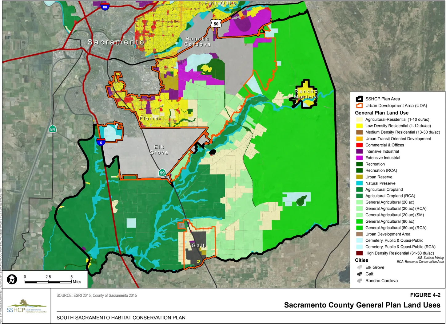
Section titled “4.3.1 Sacramento County”The County of Sacramento’s General Plan will guide development until the year 2030 (County of Sacramento 2011). Existing and planned land uses in the Plan Area located in the unincorporated county are summarized in Table 4-1 and depicted in Figure 4-2.
Table 4-1 Sacramento County General Plan Land Uses (2030)
| General Plan Land Use Designation - Land Use Component | General Plan Land Use Designation - Acreage |
|---|---|
| Agricultural Cropland | 68,019 |
| Agricultural Cropland (RCA) | 15,166 |
| Agricultural-Residential (1-10 du/ac) | 25,540 |
| Cemetery, Public, and Quasi-Public | 7,308 |
| Cemetery, Public, and Quasi-Public (RCA) | 1,645 |
| Commercial and Offices | 1,371 |
| Extensive Industrial | 4,659 |
| General Agriculture (20 ac) | 39,157 |
| General Agriculture (20 ac) (RCA) | 6 |
| General Agriculture (20 ac) (SM) | 27 |
| General Agriculture (80 ac) | 87,087 |
| General Agriculture (80 ac) (RCA) | 21,628 |
| High-Density Residential (31-50 du/ac) | 16 |
| Intensive Industrial | 3,488 |
| Low-Density Residential (1-12 du/ac) | 11,890 |
| Medium-Density Residential (13-30 du/ac) | 724 |
| Natural Preserve | 18,021 |
| Recreation | 5,163 |
| Recreation (RCA) | 472 |
| Urban Development Area | 94 |
| Urban Reserve | 1,909 |
| Urban-Transit-Oriented Development | 223 |
| Other | 44 |
| Total | 313,657 |
Source: County of Sacramento 2011.
Note:
ac = acre
du = dwelling units
RCA = Resource Conservation Area
SM = Surface Mining
Urban Policy Area and Urban Services Boundary
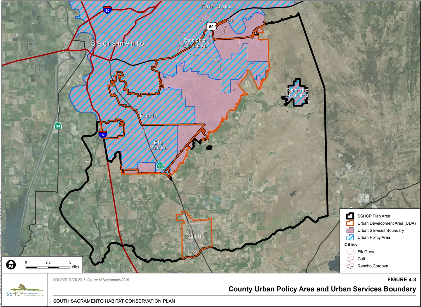
Section titled “Urban Policy Area and Urban Services Boundary”Urbanization in the unincorporated county is largely shaped by the Urban Policy Area (UPA) and Urban Services Boundary (USB). The UPA for Sacramento County was established in 1993 and is still maintained pursuant to Policy LU-1 of the 2030 Sacramento County General Plan. The UPA identifies the area in the county that is capable of providing a 20-year supply of developable land sufficient to accommodate projected growth (Figure 4-3). The intent of the UPA is to direct growth in a logical manner and to identify areas where infrastructure requiring large capital investments will be needed in the near future.
The USB was established in 1993 and is still maintained pursuant to Policy LU-2 of the 2030 Sacramento County General Plan. The USB indicates the ultimate boundary of the urban area in the unincorporated county (beyond 25 years) (Figure 4-3). It is intended to be a permanent growth boundary not subject to modification except under extraordinary circumstances. Sacramento General Plan Policy LU-1 restricts the UPA from expanding beyond the USB except when the County determines it is necessary for health and safety purposes.
The UPA and USB are the backbone of Sacramento County’s urban planning philosophy. These growth boundaries are intended to protect the county’s natural resources from urban encroachment, as well as to limit costly sprawling development patterns. While the USB is intended to be a permanent boundary, the UPA is adjusted incrementally as needed to ensure that the county can accommodate anticipated growth over the next 25-year planning cycle. The area between the two lines is reserved for future urbanization and is only to be developed when lands within the existing UPA can no longer accommodate projected growth or the project meets expansion criteria pursuant to Policy LU-120. Note that the UPA and USB only apply to the unincorporated areas of Sacramento County.
A majority of the land within the UPA identified for urban residential and commercial use is located north of the City of Elk Grove and east of the City of Sacramento. Industrial land uses are located just south of Mather Field and on properties owned by Aerojet, immediately east of Rancho Cordova and south of U.S. 50. In addition, there are three master plans that have been initiated along the Jackson Highway corridor: New Bridge, West Jackson, and Jackson Township. All three propose to expand the UPA.
Unincorporated Sacramento County (Outside the USB)
Section titled “Unincorporated Sacramento County (Outside the USB)”Outside the Urban Development Area (UDA), the eastern portion of the county within the Plan Area consists of dry pastureland suitable for cattle grazing. The land use designations are for General Agriculture with a minimum parcel size of 80 acres. The central and western portions are suitable for growing a variety of crops, including row crops, orchards, vineyards, and some irrigated pasture. These areas commonly also have General Agriculture land use designations, but with minimum parcel sizes of 20 or 40 acres. Scattered throughout the agricultural landscape are several agricultural-residential communities, including Alta Mesa (2,590 acres), Clay Station (3,095 acres), Herald (2,005 acres), Point Pleasant (471 acres), Sloughhouse (1,030 acres), and Wilton (9,785 acres).
Conservation and Open Space Policies
Section titled “Conservation and Open Space Policies”The Sacramento County General Plan includes several elements such as the agricultural, conservation, and open space elements that guide open space/agricultural resource management for areas within the unincorporated County. These elements provide a strategy for vegetation and wildlife conservation as well as protection of agricultural resources. The following is a list of policies from these elements that also support the SSHCP’s goals and objectives (County of Sacramento 2011).
-
AG-1 The County shall protect prime, statewide importance, unique and local importance farmlands located outside of the USB from urban encroachment.
-
AG-5 Projects resulting in the conversion of more than fifty (50) acres of farmland shall be mitigated within Sacramento County, except as specified in the paragraph below, based on a 1:1 ratio, for the loss of the following farmland categories through the specific planning process or individual project entitlement requests to provide in-kind or similar resource value protection (such as easements for agricultural purposes):
- Prime, statewide importance, unique, local importance, and grazing farmlands located outside the USB;
- Prime, statewide importance, unique, and local importance farmlands located inside the USB.
The Board of Supervisors retains the authority to override impacts to Unique, Local, and Grazing farmlands, but not with respect to Prime and Statewide farmlands.
However, if that land is also required to provide mitigation pursuant to a Sacramento County endorsed or approved Habitat Conservation Plan (HCP), then the Board of Supervisors may consider the mitigation land provided in accordance with the HCP as meeting the requirements of this section including land outside of Sacramento County.
Note: This policy is not tied to any maps contained in the Agricultural Element. Instead, the most current Important Farmland map from the Department of Conservation should be used to calculate mitigation.
- AG-12 The County will cooperate with landowners of agriculturally zoned properties to promote the placing of natural preserve/mitigation amenities on land, such as trees and other biota enhancing improvement, by making sure amenities are assets to both the natural preserve/mitigation areas and agriculture practices.
- AG-15 The County shall pursue opportunities to create mitigation banks, environmental mitigation sites, wildlife refuges, or other natural resource preserves wherein substantial agricultural activities that are compatible with protection of high habitat values continue, but incompatible activities and conversion for development are precluded by conservation easements.
- AG-16 Maintain private ownership by coordinating with non-profit organizations to acquire conservation easements for preserving farmlands.
- AG-17 The establishment of conservation easements combining preservation of agricultural uses, habitat values, and open space on the same property should be encouraged where feasible.
- AG-30 Provide a plan focused on noxious weed control in agricultural areas.
- CO-24 Comply with the Sacramento Areawide National Pollutant Discharge Elimination System Municipal Stormwater Permit (NPDES Municipal Permit) or subsequent permits, issued by the Central Valley Regional Water Quality Control Board (RWQCB) to the County, and the Cities of Sacramento, Elk Grove, Citrus Heights, Folsom, Rancho Cordova, and Galt (collectively known as the Sacramento Stormwater Quality Partnership [SSQP]).
- CO-25 Support the preservation, restoration, and creation of riparian corridors, wetlands, and buffer zones.
- CO-26 Protect areas susceptible to erosion, natural water bodies, and natural drainage systems.
- CO-58 Ensure no net loss of wetlands, riparian woodlands, and oak woodlands.
- CO-59 Ensure mitigation occurs for any loss of or modification to the following types of acreage and habitat function:
- Vernal pools,
- Wetlands,
- Riparian,
- Native vegetative habitat, and
- Special-status species habitat.
- CO-61 Mitigation should be consistent with Sacramento County-adopted habitat conservation plans.
- CO-65 Create a network of preserves linked by wildlife corridors of sufficient size to facilitate the movement of species.
- CO-66 Mitigation sites shall have a monitoring and management program including an adaptive management component including an established funding mechanism. The programs shall be consistent with Habitat Conservation Plans that have been adopted or are in draft format.
- CO-67 Preserves and conservation areas should have an established funding mechanism, and where needed, an acquisition strategy for its operation and management in perpetuity. This includes existing preserves such as the American River Parkway, Dry Creek Parkway, Cosumnes River Preserve and other plans in progress for riparian areas like Laguna Creek.
- CO-69 Avoid, to the extent possible, the placement of new major infrastructure through preserves unless located along disturbed areas, such as existing roadways.
- CO-71 Development design shall help protect natural resources by:
- Minimizing total built development in the floodplain, while designing areas of less frequent use that can support inundation to be permitted in the floodplain,
- Ensuring development adjacent to stream corridors and vernal pools provide, where physically reasonable, a public street paralleling at least one side of the corridor with vertical curbs, gutters, foot path, street lighting, and post and cable barriers to prevent vehicular entry.
- Projects adjacent to rivers and streams shall integrate amenities, such as trail connectivity, that will serve as benefits to the community and ecological function.
- Siting of wetlands near residential and commercial areas should consider appropriate measures to minimize potential for mosquito habitation.
- Development adjacent to steam corridors and vernal pools shall be designed in such a manner as to prevent unauthorized vehicular entry into protected areas.
- CO-73 Secure easement or fee title to open space lands within stream corridors as a condition of development approval.
- CO-74 Evaluate feasible on-site alternatives early on in the planning process and prior to the environmental review process that reduce impacts on wetland and riparian habitat and provide effective on-site preservation in terms of minimum management requirements, effective size, and evaluation criteria.
- CO-75 Maintain viable populations of special status species through the protection of habitat in preserves and linked with natural wildlife corridors.
- CO-76 Habitat conservation plans shall be adopted by the County to provide a comprehensive strategy to protect and aid in the recovery of special status species.
- CO-77 Development of open space acquisition programs within natural areas shall consider whether the area is occupied by special status species.
- CO-78 Plans for urban development and flood control shall incorporate habitat corridors linking habitat sites for special status species. (Please also refer to the Open Space Element for related policies.)
- CO-125 Restore concrete sections of rivers and streams to natural or naturalized channels, where feasible for increased flood or conveyance capacity and groundwater recharge.
- CO-126 Prohibit obstruction or underground diversion of natural waterways.
- CO-132 Protect native vegetative habitats from improper grazing regimes on public lands and inform private land operators of how they may minimize impacts to these habitats.
- CO-133 Prohibit native vegetative habitat mitigation and/or other public plantings onto incompatible substrates i.e., tree planting in vernal pool hardpan.
- CO-134 Maintain and establish a diversity of native vegetative species in Sacramento County.
- CO-135 Protect the ecological integrity of California Prairie habitat.
- CO-138 Protect and preserve non-oak native trees along riparian areas if used by Swainson’s Hawk, as well as landmark and native oak trees measuring a minimum of 6 inches in diameter or 10 inches aggregate for multi-trunk trees at 4.5 feet above ground.
- OS-1 Actively plan to protect, as open space, areas of natural resource value, which may include but are not limited to wetlands preserves, riparian corridors, woodlands, and floodplains associated with riparian drainages.
- OS-2 Maintain open space and natural areas that are interconnected and of sufficient size to protect biodiversity, accommodate wildlife movement and sustain ecosystems.
Demographics
Section titled “Demographics”The County of Sacramento is approximately 994 square miles. As of 2013, the estimated population of Sacramento County was approximately 1,462,131 persons with a 2010 U.S. Census estimate base of 1,418,788 persons (U.S. Census Bureau 2014a). There are approximately 558,807 housing units in the County as of 2010 (U.S. Census Bureau 2014a).
4.3.2 Rancho Cordova
Section titled “4.3.2 Rancho Cordova”The City of Rancho Cordova is located in central Sacramento County. Rancho Cordova is bisected by U.S. 50 between Bradshaw Road and Sunrise Boulevard. Between those points, the city extends north to the American River and south to Old Placerville Road. The eastern part of the city continues south of Folsom Boulevard between Sunrise Boulevard and Grant Line Road to the west and east, respectively. The southeastern part of the city is defined by Grant Line Road and Jackson Highway (Figure 4-1). Rancho Cordova encompasses approximately 20,000 acres and has a population of approximately 65,000 people (U.S. Census Bureau 2010a). With approximately 15,179 acres located within the Plan Area, Rancho Cordova makes up approximately 4.5% of the entire Plan Area.
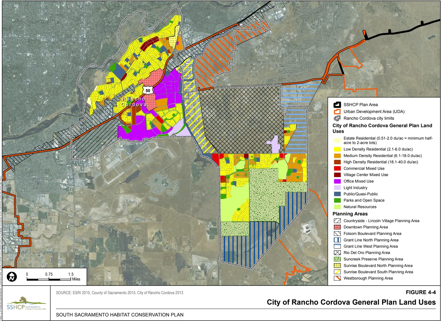
Rancho Cordova’s General Plan will guide development until the year 2030 (City of Rancho Cordova 2006). The most prevalent planned land use within the City of Rancho Cordova, as identified by the City’s General Plan, is residential (Table 4-2 and Figure 4-4). A majority of the existing urban residential land use designations are located in the northwestern portion of the city, while expanding, new residential land use designations are dominant in the southeastern half. Areas identified for industrial uses are prevalent along U.S. 50. Commercial land use designations are also located along U.S. 50 but additionally occur along commercial corridors like Sunrise Boulevard, Folsom Boulevard, and Coloma Road. Some infill in the form of residential and commercial land use is likely to occur within already established areas of the city; however, a majority of new development will occur in greenfield areas (undeveloped areas earmarked for future development) in southeastern Rancho Cordova.
Table 4-2 City of Rancho Cordova General Plan Land Uses
| General Plan Land Use - Land Use Component | General Plan Land Use - Acreage |
|---|---|
| Low-Density Residential (2.1-6.0 du/ac) | 1,055 |
| Medium-Density Residential (6.1-18.0 du/ac) | 564 |
| High-Density Residential (18.1-40.0 du/ac) | 127 |
| Commercial Mixed-Use | 122 |
| Village Center Mixed-Use | 12 |
| Office Mixed-Use | 1,003 |
| Light Industry | 252 |
| Public/Quasi-Public | 109 |
| Parks and Open Space | 347 |
| Natural Resources | 714 |
| Special Planning Area/Specific Plan Area/Other | 2,099 |
| Total | 14,706 |
Source: City of Rancho Cordova 2006, General Plan Land Use Diagram.
Note: du = dwelling unit; ac = acre
Conservation and Open Space Policies
Section titled “Conservation and Open Space Policies”The City of Rancho Cordova’s General Plan includes several policies that provide for the conservation of natural resources for areas within the City. The following is a list of policies from the City of Rancho Cordova’s General Plan that support the SSHCP’s Conservation Strategy (City of Rancho Cordova 2006).
- Policy NR.1.1 - Protect rare, threatened, and endangered species and their habitats in accordance with state and federal law.
- Action NR.1.1.1 - Incorporate large habitat preserves and interconnected wildlife corridors in new development areas to provide ample space for animal movement.
- Action NR.1.1.2 - Review projects through the entitlement process and [California Environmental Quality Act] CEQA analysis to ensure that they comply with this policy if the site contains unique habitat, creeks, and/or wooded corridors.
- Action NR.1.1.3 - As part of the consideration of development applications for individual Planning Areas containing habitats that support special-status plant and animal species that are planned to be preserved, the City shall require that these preserved habitats have interconnections with other habitat areas in order to maintain the viability of the preserved habitat to support the special-status species identified. The determination of the design and size of the ‘interconnections’ shall be made by the City, as recommended by a qualified professional, and will include consultation with the California Department of Fish and Game [Wildlife] and U.S. Fish and Wildlife Service.
- Action NR.1.1.4 - Prior to the approval of any public or private development project in areas containing trees, the City shall require that a determinate survey be conducted during the nesting season (March 1 and August 31) to identify if active nesting by birds protected under the Migratory Bird Treaty Act (MBTA) is taking place. If all site disturbance is to occur outside this time, the actions described in this mitigation measure are not required. If nesting activity is observed, consultation with the City of Rancho Cordova Planning Department shall be conducted in order to determine the appropriate mitigation, if any, required to minimize impacts to nesting birds. No activity may occur within 100 feet of any nesting activity or as otherwise required following consultation with the California Department of Fish and Game [Wildlife].
- Policy NR.1.2 - Conserve Swainson’s hawk habitat consistent with state policies and Department of Fish and Game [Wildlife] guidelines.
- Action NR.1.2.1 - Establish a Swainson’s Hawk Ordinance in coordination with the California Department of Fish and Game [Wildlife] to establish the process of mitigating for the loss of Swainson’s hawk foraging habitat based on habitat value lost to development. The ordinance will set forth a process where habitat lost to development will be mitigated through the permanent protection of equivalent or better existing habitat conditions (referred to hereafter as ‘mitigation lands’). The specific required mitigation ratios (habitat acreage lost versus mitigation lands) and any other provisions to mitigation process shall be established through technical studies as part of the development of the ordinance and will take into account value of habitat to be converted in relation to habitat value of the mitigation lands (e.g., relation to nesting sites), proximity of the mitigation lands to adjacent conditions affecting habitat (e.g., nearby land uses and already permanently protected lands), and other relevant factors. The ordinance will also establish standards ensuring that mitigation land will be adequately protected and managed in perpetuity (e.g., via conservation easement, deed restriction or other appropriate method), and setting forth the timing of the required provision of mitigation lands in relation with the timing of the loss of habitat in the City (as its boundaries may be changed through subsequent annexations), such that mitigation lands shall be provided no later than prior to ground disturbance.
- Policy NR.1.4 - Discourage the planting of invasive species.
- Action NR.1.4.1 - Create an educational leaflet that identifies common invasive species and recommends the planting of non-invasive species.
- Action NR.1.4.2 - The City shall adopt and maintain a Noxious Weed Ordinance. The Noxious Weed Ordinance shall include regulatory standards for construction activities that occur adjacent to natural areas to inhibit the establishment of noxious weeds through accidental seed import.
- Policy NR.1.6 - Participate in the development of a habitat conservation plan to address the unique biological resources in Rancho Cordova.
- Policy NR.1.8 - The City shall encourage creation of habitat preserves that are immediately adjacent to each other in order to provide interconnected open space areas for animal movement.
- Policy NR.1.9 - The City shall require that impacts to riparian habitats be mitigated at a no net loss of existing function and value based on field survey and analysis of the riparian habitat to be impacted. No net loss may be accomplished by avoidance of the habitat, restoration of existing habitat, or creation of new habitat, or through some combination of the above.
- Policy NR.1.10 - The City shall avoid the placement of new roadways within habitat preserves to the maximum extent feasible.
- Policy NR.1.11 - In such cases where habitat preserves are crossed by a roadway, or where two adjacent preserves are separated by a roadway, the roadway shall be designed or updated with wildlife passable fencing separating the roadway from the preserve and/or shall incorporate design features that allow for the movement of wildlife across or beneath the road without causing a hazard for vehicles and pedestrians on the roadway.
- Policy NR.2.1 - Require mitigation that provides for ‘no net loss’ of wetlands consistent with current State and federal policies.
- Action NR.2.1.1 - During the environmental review process, evaluate feasible on-site alternatives that will reduce impacts to wetland resources and effectively preserve these resources.
- Policy NR.2.2 - Ensure that direct and indirect effects to wetland habitats are minimized by environmentally sensitive project siting and design, to the maximum extent feasible.
- Policy NR.3.2 - In general, the City will encourage the preservation of existing location, topography, and meandering alignment of creeks. Where necessary, and if consistent with other City policies, the creation and realignment of creek corridors shall be constructed to recreate the character of the natural creek corridor. Channelization and the use of concrete within creek corridors shall not be supported.
- Action NR.3.2.1 - Develop guidelines for channel creation or modification that will ensure channel meander, naturalized side slope, and varied channel bottom elevation are considered in design.
- Action NR.3.2.2 - Adopt and implement improvement standards for soft bottom channels.
Demographics
Section titled “Demographics”The City of Rancho Cordova is approximately 34 square miles. As of 2013, the estimated population of Rancho Cordova was 67,911 persons with a 2010 U.S. Census estimate base of 64,805 persons (U.S. Census Bureau 2010a, 2014b). There were approximately 25,479 housing units in the City as of 2010 (U.S. Census Bureau 2014b).
4.3.3 Galt
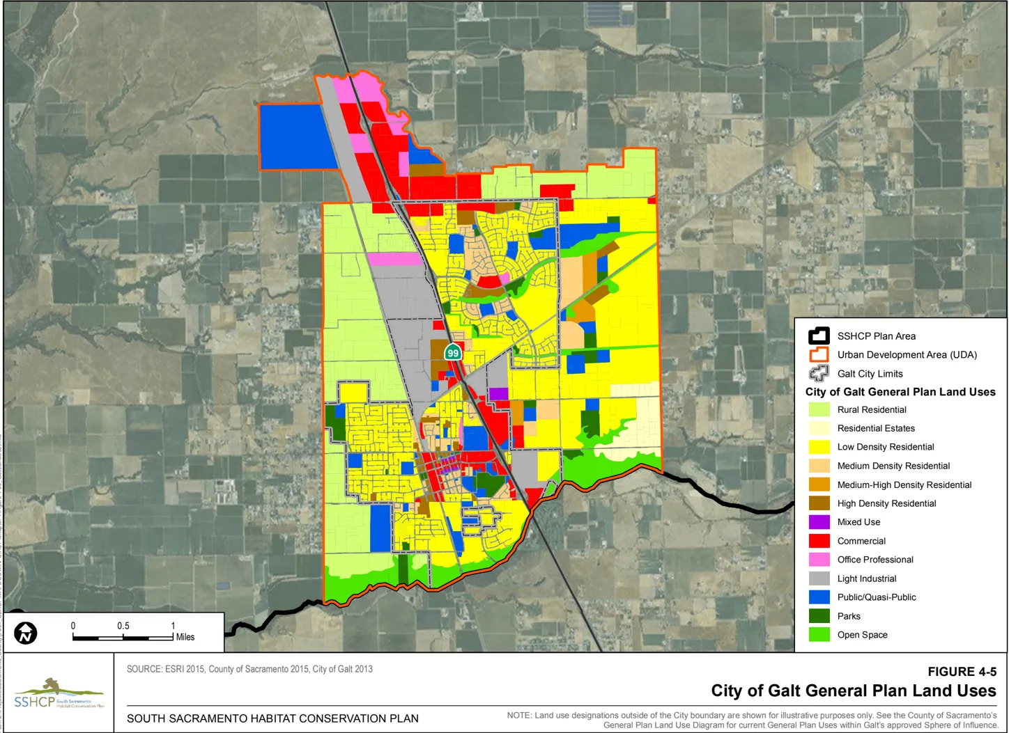
Section titled “4.3.3 Galt”The City of Galt is located in southern Sacramento County and can be generally described as extending from Dry Creek on the south to Twin Cities Road on the north, and from McFarland Street/Sparrow Drive on the west to Marengo Road on the east (Figures 4-1 and 4-5). Galt encompasses approximately 3,760 acres of land and has a population of approximately 23,600 (U.S. Census Bureau 2010b).
Galt makes up approximately 1% of the Plan Area. Galt’s 2030 General Plan will guide development until the year 2030 (City of Galt 2009). The most prevalent planned land use in Galt is low-density residential (Table 4-3).
Table 4-3 City of Galt General Plan Land Uses
| General Plan Land Use - Land Use Component | General Plan Land Use - Acreage |
|---|---|
| Rural Residential | 1 |
| Low-Density Residential (0-6 du/ac) | 1,401 |
| Medium-Density Residential (5-8 du/ac) | 216 |
| High-Density Residential (14-24 du/ac) | 140 |
| Mixed-Use | 5 |
| Commercial | 271 |
| Office Professional | 11 |
| Light Industrial | 284 |
| Public/Quasi-Public | 227 |
| Parks | 109 |
| Open Space | 153 |
| Other | 37 |
| Total | 2,854 |
Source: City of Galt 2009 (roads or other infrastructure not included).
Note: du = dwelling unit; ac = acre.
Conservation and Open Space Policies
Section titled “Conservation and Open Space Policies”The City of Galt General Plan includes several policies that provide for the conservation of natural resources for areas within the City. The following is a list of policies from the City of Galt’s General Plan that support the SSHCP’s Conservation Strategy (City of Galt 2009).
- Policy COS-1.10: Ecological Features Retention. The City shall retain to the extent feasible the ecological features of the creeks, sloughs, and rivers in their natural state.
- Policy COS-1.11: Riparian Corridor Protection. The City shall endeavor to protect, preserve, and improve riparian corridors.
- Policy COS-1.13: No Net Loss of Wetlands. The City shall review development proposals in accordance with applicable local, State, and Federal statues protecting jurisdictional wetlands (Section 404 of the Clean Water Act) and require that new developments have no net loss of existing wetland habitats.
- Policy COS-2.1: Sensitive Species Protection. The City should require minimization of impacts to protect mature trees, vernal pools, and any threatened endangered or other sensitive species when approving new development.
- Policy COS-2.3: Biologically Sensitive Area Development. The City should require new development in areas that are known to have particular value for biological resources to maximize preservation of sensitive vegetation and wildlife habitat.
- Policy COS-2.4: Federal, State, and Local Statutes Compliance. The City shall review development proposals in accordance with applicable Federal, State, and local statutes protecting special-status species and jurisdictional wetlands.
- Policy COS-2.7: Regional Habitat Conservation Efforts Coordination. The City shall continue to coordinate efforts with Sacramento County to develop the South Sacramento Habitat Conservation Plan.
- Policy COS-3.1: Riparian Protection. The City should require the protection of existing riparian vegetation along stream courses in the city.
- Policy COS-3.2: Mature Tree and Woodland Preservation. The City shall encourage retention of mature trees and woodlands to the maximum extent possible.
- Policy COS-4.1: Prime Agricultural Land Preservation. The City shall work to preserve prime agricultural lands surrounding the Planning Area from future development by creating a clear and sensitive urban transition to minimize land use conflicts and protect long-term agriculture.
- Policy COS-4.4: Open Space Protection. The City shall, where appropriate, permanently protect as open space areas of natural resource value, including wetlands preserves, riparian corridors, woodlands, and floodplains.
- Policy COS-4.8: Open Space and Natural Area Connectivity. The City shall maintain open space and natural areas that are interconnected and of sufficient size to protect biodiversity, accommodate wildlife movement, and to provide more sustainable ecosystems.
- Policy COS-4.9: Open Space Preservation. The City shall work to preserve open space that provides both habitat for wildlife and increases the quality of life for people. This can include maintaining areas for trails, bike and pedestrian paths, and open space buffers used as separators between neighborhoods to provide an identity and a sense of place.
- Policy PFS-2.3: Surface Water Protection. The City shall protect surface water resources, including rivers, creeks, streams, sloughs, and marshes, from development impacts.
Demographics
Section titled “Demographics”The City of Galt is approximately 6 square miles. As of 2013, the estimated population of Galt was approximately 24,472 persons with a 2010 U.S. Census estimate base of 23,647 persons (U.S. Census Bureau 2010b, 2014c). There are approximately 7,678 housing units in the City as of 2010 (U.S. Census Bureau 2014c).
4.3.4 Existing and Proposed Extra-Territorial Spheres of Influence
Section titled “4.3.4 Existing and Proposed Extra-Territorial Spheres of Influence”A sphere of influence (SOI) is ‘a plan for the probable physical boundaries and service area of a local government agency’ (California Government Code, Section 56076). An SOI may reflect the limits of probable future growth of a jurisdiction. An extra-territorial SOI is one that extends beyond a local governmental jurisdiction’s formal boundary. SOI applications are reviewed and approved by the Sacramento Local Agency Formation Commission (LAFCO). The following provides descriptions of extra-territorial and proposed SOI areas within the Plan Area. They are depicted in Figure 4-1.
City of Sacramento SOI
Section titled “City of Sacramento SOI”The City of Sacramento has four extra-territorial SOI areas that extend into the Plan Area. The largest is approximately 9,500 acres in size and includes the unincorporated South Sacramento area along Interstate 5 bounded to the east by Elk Grove Florin Road and to the south by Calvine Road. This area is largely developed but does have pockets of scattered open lands, particularly to the southeast along Elk Grove Florin Road. The second area extends 164 acres beyond the existing city limits to Hedge Avenue between Fruitridge Road and Elder Creek Road. It is characterized by scattered agricultural-residential development with several larger open lots. The third area overlaps with the Plan Area by approximately 1,930 acres. The area that overlaps with the Plan Area is bounded by the Sacramento city limits to the west, U.S. 50 to the north, Bradshaw Road to the east, and Jackson Highway to the south. This area is also largely developed. The fourth SOI area overlaps with the Plan Area by approximately 700 acres located within the Beach Lake area. The land is owned by the Sacramento Regional County Sanitation District (SRCSD) south of the existing city limits between Interstate 5 and Franklin Boulevard and largely acts as a buffer to the existing wastewater treatment plant. Annexation of land from any of these areas to the City of Sacramento would transfer land use authority for the area to the city, replacing existing land use regulation by Sacramento County and the County’s planning and zoning designations.
City of Galt SOI
Section titled “City of Galt SOI”The City of Galt’s SOI encompasses roughly 4,500 acres of land to the west, east, and north of the existing city limits. The western portion of the SOI is formed by the Sacramento County line, Sargent Avenue, and Twin Cities Road. The eastern portion of the Galt SOI is bounded by the County line, Cherokee Lane, and Twin Cities Road. The northern portion of their SOI includes lands north of Twin Cities Road between Cherokee Lane on the east and the Union Pacific Railroad on the west, and then generally following Skunk Creek east and southwest of Highway 99, south to a point approximately one-third of a mile north of Twin Cities Road easterly to Cherokee Lane (see Figure 4-1). Much of the SOI area west and north of Galt is scattered agricultural-residential development, but larger intact cropland and pasture areas are still present, particularly toward the southern extent of the SOI where it borders Dry Creek. The eastern portion of the SOI exhibits some agricultural-residential development but is predominantly crop and pasture lands. Growth in the Galt SOI is proposed to be a mixture of residential, commercial, industrial, and office professional development, as well as some unspecified public and quasipublic land uses. Annexation of land from any of these areas to the City of Galt would transfer land use authority for the area from Sacramento County to the City, replacing existing County land use regulations and the County’s planning and zoning designations.
4.4 Demographics of the Plan Area
Section titled “4.4 Demographics of the Plan Area”General Projections
Section titled “General Projections”As coastal communities continue to build out and the cost of living in those communities steadily increases, new growth will continue to shift to inland regions, mimicking patterns of growth that were observed in Southern California during the 1980s and 1990s. Sacramento Area Council of Governments (SACOG) has forecast that Sacramento County will see an increase in population from 2,057,200 in 2005 to 2,519,947 by 2020 and over 3,000,000 by 2035 (SACOG 2005, 2012; County of Sacramento 2011). Population growth is not expected to slow much past 2025, and current SACOG projections are that the population within the Sacramento region could swell to approximately 3,653,000 people by 2050. A large portion of this growth is expected to occur in southern Sacramento County within the Plan Area. Although Sacramento County’s population and housing needs are clearly expected to grow over time, the rate of growth is not expected to be linear. SACOG estimates slower growth rates through 2020 followed by a period of higher growth to approximately 2035 (County of Sacramento 2013, Chapter 5). Population and housing projections have an inherent level of uncertainty; however, a population model such as SACOG’s population synthesis process is a standard, widely accepted approach to developing population projections.
SACOG Blueprint Project
Section titled “SACOG Blueprint Project”SACOG recognized that the pattern of growth in the six-county area of El Dorado, Placer, Sacramento, Sutter, Yolo, and Yuba Counties may lead to the loss of habitat, an increase in traffic congestion, an increase in pollution, and the loss of agricultural land and open space. The SACOG Blueprint Project set out to identify the region’s housing/employment needs and to propose different scenarios for development to accommodate that need for the next 45 years. SACOG identified a ‘base-case scenario’ 1 representing current development trends and made projections out to 2050. Alternative strategies were developed, each implementing differing levels of smart growth strategies. After extensive outreach and public involvement, the SACOG Board adopted its preferred scenario in December 2004. The preferred scenario represents a balanced approach that emphasizes infill and revitalization, and relies on smart growth principles to encourage development at higher densities, while offering a wider choice of housing options (SACOG 2010). It should be noted that the growth projections used to develop the blueprint are now viewed as being overly optimistic.
Both the blueprint base-case scenario and the blueprint preferred alternative identify urban development within the Plan Area. The preferred scenario in Rancho Cordova and eastern Sacramento County (within the USB) are identified for more compact development with almost twice the population of the base-case scenario, which slates the areas for continued low-density growth. The remaining portion of the Plan Area (i.e., the east, southeast, and south county outside the USB) would see limited development to the south of the City of Elk Grove and the City of Folsom under the preferred scenario, as opposed to the base-case scenario that shows significant growth into these rural areas.
4.5 References
Section titled “4.5 References”- California Government Code, Section 56076. General: Definitions.
- City of Galt. 2009. 2030 General Plan Policy Document . Final. April 2009. Accessed February, 11, 2015. http://www.ci.galt.ca.us/Modules/ShowDocument.aspx?documentid=13095.
- City of Rancho Cordova. 2006. Rancho Cordova General Plan. Adopted June 26, 2006, Accessed February 11, 2015. http://www.cityofranchocordova.org/index.aspx?page=298.
- County of Sacramento. 2011. Sacramento County General Plan of 2005-2030 . Adopted November 9, 2011. Accessed February 11, 2015. http://www.per.saccounty.net/PlansandProjectsIn-Progress/Pages/GeneralPlan.aspx.
- County of Sacramento. 2013. Sacramento County Housing Element of 2013-2021. Sacramento, California: Sacramento County Department of Community Development . Adopted October 8, 2013. Accessed online June 17, 2015. http://www.per.saccounty.net/PlansandProjectsIn-Progress/Pages/HousingElementUpdate\_HOME.aspx.
- SACOG (Sacramento Area Council of Governments). 2005. ‘Projections of Employment, Population, Households, and Household Income in the SACOG Region for 2000-2050.’ Prepared for SACOG by the Center for Continuing Study of the California Economy and DB Consulting. September 15, 2005.
- SACOG. 2010. Sacramento Region Blueprint Transportation/Land Use Plan . April 2010.
- SACOG. 2012. Metropolitan Transportation Plan/Sustainable Communities Strategy 2035 . April 19, 2012.
- U.S. Census Bureau. 2010a. ‘2010 Demographic Profile: CA - Rancho Cordova City.’ Accessed February 16, 2015. http://www.census.gov/popfinder/.
- U.S. Census Bureau. 2010b. ‘2010 Demographic Profile: CA - Galt City.’ Accessed February 16, 2015. http://www.census.gov/popfinder/.
- U.S. Census Bureau. 2014a. ‘Sacramento County, California.’ State and County QuickFacts. Last updated December 2014. Accessed February 16, 2015. http://quickfacts.census.gov/qfd/states/06/06067.html.
- U.S. Census Bureau. 2014b. ‘Rancho Cordova (City), California.’ State and County QuickFacts. Last updated December 2014. Accessed February 16, 2015. http://quickfacts.census.gov/qfd/states/06/0628112.html.
- U.S. Census Bureau. 2014c. ‘Galt (City), California.’ State and County QuickFacts. Last updated December 2014. Accessed February 16, 2015.
Footnotes
Section titled “Footnotes”-
A projection of how the six-county Sacramento region would grow if recent development trends continued for the next 50 years. ↩