Safety Element
Sacramento County General Plan
Safety Element
Section titled “Sacramento County General Plan Safety Element”Adopted December 15, 1993
Amended November 9, 2011 & December 13, 2016 & September 26, 2017
Introduction
Section titled “Introduction”The purpose of the Safety Element is to identify hazards with the potential to occur in Sacramento County and to formulate policies that avoid or minimize risk in order to provide adequate public protection. This Element focuses on policies which minimize and prevent hazards, both natural and man-made, related to seismic events, floods, and fires pursuant to the requirements of Government Code Section 65302(g)(1). The reader can refer to the Safety Element Background Section for a more detailed examination of these hazards.
For a discussion of safety issues related to airports, the reader is referred to the Noise Element. For a discussion of safety issues related to hazardous materials, the reader is referred to the Hazardous Material Element.
Goals and Policies
Section titled “Goals and Policies”Seismic And Geologic Hazards
Section titled “Seismic And Geologic Hazards”Seismic hazards are those associated with faulting, groundshaking, liquefaction, and seiches whereas geologic hazards are those associated with subsidence, expansive soils, landslides, and erosion. Geologic hazards are more prevalent than seismic hazards in Sacramento County. Because no major faults transect Sacramento County, the County is less affected by seismic events than other portions of the state. Nevertheless, some property damage has occurred in the past largely due to major seismic events occurring in adjacent areas, especially the San Francisco Bay area and, to a lesser extent, the foothills of the Sierras. The areas of Sacramento County most vulnerable to seismic and geologic hazards are those areas subject to liquefaction and subsidence, such as the downtown area and the Delta.
Minimize the loss of life, injury, and property damage due to seismic and geological hazards.
Policies:
Section titled “Policies:”The County shall require geotechnical reports and impose the appropriate mitigation measures for new development located in seismic and geologically sensitive areas.
The County shall protect citizens from the hazards of old architecture affected by seismic activity.
The County shall support efforts by Federal, State, and other local jurisdictions to investigate local seismic and geological hazards and support those programs that effectively mitigate these hazards.
The County shall prohibit development on ground surfaces which exceed 40 percent in slope, such as the bluff areas along the American River. Development shall be set back from these slopes at a distance established by the Zoning Code
Implementation Measures
Section titled “Implementation Measures”- The County shall designate generalized areas subject to seismic and geological hazards. Development proposals falling within these areas shall include a geotechnical report with appropriate mitigation measures if a seismic or geological hazard is found to exist. (PLANNING & ENVIRONMENTAL REVIEW)
- The County shall draft an ordinance for consideration by the Board of Supervisors to establish a program for the removal or strengthening of poorly anchored parapets or architectural detailing on existing buildings. (PLANNING & ENVIRONMENTAL REVIEW, BUILDING PERMITS & INSPECTION, COUNTY ENGINEERING)
Flooding
Section titled “Flooding”Minimize the loss of life, injury, and property damage due to flood hazards.
Historically, Sacramento County was much more vulnerable to riverine flooding before the extensive system of dams, levees, overflow weirs, drainage pumping plants, and flood control bypass channels were constructed on the American and Sacramento Rivers and their tributary creeks and drainages. Due to existing infrastructure as well as ongoing maintenance and improvements, Sacramento County is reasonably safe from catastrophic flooding. In fact, the County is ranked among the nation’s best on the FEMA Community Rating System (CRS). In 2017, the County was raised from a Class 3 to a Class 2, becoming one of only six Class 2 communities nationwide. Participation in this program, as well as its rise from Class 9 rating in 1992 to Class 2 in 2017, shows that flood protection and floodplain management is very important to the leadership of the County. Nevertheless, the County has flood emergency plans in case of local or regional flooding. There are some areas of the County which may still experience localized flooding. In areas of localized flooding, the risk is reduced by more stringent development standards pursuant to the County Floodplain Management Ordinance. While the probability of catastrophic flooding may be small, the damage potential is high. Sacramento Area Flood Control Agency continues to work diligently to make further improvements to the river flood control systems. Projects that are anticipated to be completed within the planning horizon of this General Plan will continue the County’s efforts toward more effective flood protection. These projects include the raising of Folsom Dam and its dikes, spillway improvements to Folsom Dam, and improvements to various levee systems within the County. The ultimate goal is to improve flood protection along the American River to the California Department of Water Resources’ 200-year flood protection standard. (Updated 2016)
Policies in this section address flood avoidance and emergency response, interagency coordination, location and design of public facilities, location and design of new development, floodplain fill, levee protection and the requirements of drainage plans. The policies required by Senate Bill-5 (Machado, 2007) on floodplain management are found in the Conservation Element, the Safety Element and the Safety Element Background document. Conservation Element policies CO-30 & CO-105a stress the importance of preserving natural drainage. Safety Element policies SA6a-c and SA-37 emphasize the importance of interagency coordination for maintenance of facilities and for emergency response. Policies SA-18a and b require levee setbacks that will allow regular maintenance or emergency repair. A key requirement of Senate Bill-5 is addressed in SA-22a which differentiates between flood-protection standards for project sites that are subject to the Urban Level of Flood Protection (ULOP) requiring 200-year flood protection, and project sites that are subject to the 100-year FEMA flood standard . (Added 2016)
The text and policies of this General Plan use the following definitions for classifying and managing areas subject to flooding. (Added 2016)
-
Flood Hazard Zone. This term is used to identify project sites that must be evaluated for potential flood hazards (SA-23) and to locate appropriate sites for public facilities (SA-7). It is defined by the State of California, and in this General Plan, as an area subject to flooding that is delineated as either a Special Flood Hazard Area or an Area of Moderate Flood Hazard on an official Flood Insurance Rate Map (FIRM) issued by the Federal Emergency Management Agency (FEMA).
- Special Flood Hazard Area. This term is defined in the Sacramento County Flood Plan Management Ordinance as an area shown on the FEMA Flood Insurance Study and the FIRM as Zone A, AO, A1-30, AE, A99, AH or AR. These zones are lands covered by the floodwaters of the base flood (100-year) where the National Flood Insurance Program's floodplain management regulations apply.
- Area of Moderate Flood Hazard. These areas are shown by the letter 'X' on the Flood Insurance Rate Maps (FIRM). (Older maps use the letters 'B' or 'C'.)
-
Local Flood Hazard Area. An area having risk of flooding in a base flood event as determined by the Floodplain Administrator, and which is supplemental to federally defined special flood hazard areas. The base flood elevation related to actual surveyed ground elevation is the local flood hazard area.
The Safety Element Background document contains data required by Senate Bill-5 primarily in the form of mapped data. (Added 2016)
Any development located within the Central Valley Flood Protection Board’s jurisdiction is required to apply for a permit from the CVFPB per the California Code of Regulations, Title 23 Waters, Division 1, Article 3, Section 6. Their authority extends over (a) the levee section, (b) the waterward area between project levees, (c) a 10-foot-wide strip adjacent to the landward levee toe, (d) within 30 feet of the top of the banks of unleveed project channels, (e) within Designated Floodways adopted by the CVFPB, and (f) activities outside of these limits which could adversely affect the flood control projects. (Added 2011)
Additional floodplain information may be obtained by contacting the Sacramento County Department of Water Resources. The Sacramento County Floodplain Management Ordinance contains additional information regarding safety and development in or near designated floodplains. Historical data on flooding, including locally prepared maps of areas that are subject to flooding, areas that are vulnerable to flooding after wildfires, and sites that have been repeatedly damaged by flooding is available in the Safety Element Background document and the Sacramento County Local Hazard Mitigation Plan. (Added 2011)
Policies:
Section titled “Policies:”A comprehensive drainage plan for major planning efforts shall be prepared for streams and their tributaries prior to any development within the 100-year floodplain and/or the 200-year floodplain in areas subject to the Urban Level of Flood Protection, defined by full watershed development without channel modifications. The plan shall:
- Determine the elevation of the future 100-year flood and/or the 200-year flood in areas subject to the Urban Level of Flood Protection, associated with planned and full development of the watershed;
- Determine the boundaries of the future 100-year floodplain and/or the 200-year floodplain in areas subject to the Urban Level of Flood Protection, for both flood elevations (planned and full development) based on minimum 2-foot contour intervals;
- Assess the feasibility of gravity drainage into the existing flowline of the stream;
- Assess the feasibility of alternative means of drainage into the stream;
- Identify potential locations for sedimentation ponds and other stormwater treatment facilities;
- Determine practical channel improvements and/or detention basins to provide the flood control needs of the proposed development;
- Determine the location and extent of marsh, vernal pool and riparian habitat;
- Develop measures for protecting and mitigating natural habitat;
- Develop measures for protecting and mitigating for federal and state listed endangered species;
- Develop and ensure implementation of measures that would reduce vector larvae;
- Identify appropriate plant species to be included as part of the natural features of the comprehensive drainage plan. (Modified 2016)
The County will coordinate with the City of Sacramento, the Army Corps of Engineers, the Sacramento Area Flood Control Agency, and other Federal, State and local governments and agencies to develop a plan to finance, develop and construct flood control project improvements to reduce flooding potential in Sacramento County. The construction of flood control projects along the Sacramento and American Rivers and the immediate connection of local streams to these rivers shall be included in these projects. Such projects should provide 200-year flood protection.
SA-6a.
Section titled “SA-6a.”The County will continue to coordinate with parties responsible for flood management facilities and structures (e.g., pump stations, levees, canals, channels, and dams) to provide proper maintenance and/or improvements. (Added 2016)
SA-6b.
Section titled “SA-6b.”The County will continue to coordinate with relevant organizations and agencies (e.g., Federal Emergency Management Agency (FEMA) and State of California Department of Water Resources (CADWR)) when updating floodplain mapping, flood management plans, local hazard mitigation plans, and other emergency response plans to consider the impacts of urbanization and climate change on longterm flood safety and flood event probabilities. (Added 2016)
SA-6c.
Section titled “SA-6c.”The County will continue to coordinate with local, regional, state, and federal agencies to maintain an adequate flood management information base, prepare risk assessments, and identify strategies to mitigate flooding impacts . (Added 2016)
In accordance with the County Floodplain Management Ordinance, the County shall locate, when feasible, new essential public facilities outside of flood hazard zones 1 , including hospitals and health care facilities, emergency shelters, fire stations, emergency command centers, and emergency communications facilities; or identify construction methods or other methods to minimize damage if these facilities are located in flood hazard zones.
Maintain the structural and operational integrity of essential public facilities during flooding.
New and modified bridge structures should minimize any increase in water surface elevations of the 100-year floodplain, or the 200-year floodplain in areas subject to the Urban Level of Flood Protection. (Modified 2016)
SA-10.
Section titled “SA-10.”Fill within the 100-year floodplain of creeks outside of the Urban Service Boundary is permissible to accommodate structures (e.g., residential, commercial, accessory) and septic systems, and only when the Board of Supervisors finds that the fill will not impede water flows or storm runoff capacity. Such development shall not cause an increase in base flood elevation of the 100-year floodplain exceeding 0.10 feet, unless analysis clearly indicated that the physical and/or economic use of adjacent property within the floodplain will not be adversely affected. A permit is required if the fill is within the jurisdiction of the Central Valley Flood Protection Board.
SA-11.
Section titled “SA-11.”The County shall implement the improvement of natural drainage channels and certain floodplains for urbanized or urbanizing portions of the County to reduce local flooding. Such improvements shall comply with the General Plan policies contained in the Conservation Element, Urban Streams, and Channel Modification Section.
SA-12.
Section titled “SA-12.”The County shall continue local efforts that encourage implementation of the Federal Flood Insurance Program.
SA-13.
Section titled “SA-13.”Where new upstream development in Sacramento County will increase or potentially impact runoff onto parcels downstream in a neighboring jurisdiction, such as the City of Sacramento, Sacramento County will coordinate with the appropriate neighboring jurisdiction to mitigate such impacts.
SA-14.
Section titled “SA-14.”The County shall require, when deemed to be physically or ecologically necessary, all new urban development and redevelopment projects to incorporate runoff control measures to minimize peak flows of runoff and/or assist in financing or otherwise implementing Comprehensive Drainage Plans.
SA-15.
Section titled “SA-15.”The County shall regulate, through zoning and other ordinances, land use and development in all areas subject to potential flooding and prohibit urban uses on unprotected flood land.
SA-16.
Section titled “SA-16.”Deny creation of parcels that do not have buildable areas outside the 100-year floodplain, or the 200-year floodplain in areas subject to the Urban Level of Flood Protection, unless otherwise allowed in the Floodplain Management Ordinance. (Modified 2016)
SA-17.
Section titled “SA-17.”For residential zoning, the area outside the 100-year floodplain, or the 200-year floodplain in areas subject to the Urban Level of Flood Protection , must be contiguous or reasonably situated to provide buildable area for a residence and associated structures. Examples of structures include swimming pools, sheds, barns, detached garages, and other outbuildings that are normally associated with residential development. There may be exceptions (such as the Delta area) as allowed in the Floodplain Management Ordinance. (Modified 2016)
SA-18.
Section titled “SA-18.”Vehicular access to the buildable area of newly created parcels must be at or above the 10-year flood elevation. Exceptions may be made when the existing public street from which access is obtained is below the 10-year flood elevation. There may be exceptions (such as the Delta area) as allowed in the Floodplain Management Ordinance.
SA-18a.
Section titled “SA-18a.”Provide unobstructed access to levees on county-owned lands, whenever practicable, for maintenance and emergencies. Require setbacks and easements to provide access to levees from private property . (Added 2016)
SA-18b.
Section titled “SA-18b.”Urban flood control levees should have adequate setbacks consistent with local, regional, State, and federal design and management standards. (Added 2016)
SA-19.
Section titled “SA-19.”Creation of lots that require watercourse crossings for single lots, or that will likely encourage watercourse crossings to be built by property owners (lots with useable area on both sides of a watercourse) will not be allowed unless a detailed hydraulic study is approved by Water Resources and there is found to be no adverse impact in accordance with the County Floodplain Management Ordinance.
SA-20.
Section titled “SA-20.”Levees for the purpose of floodplain reclamation for development shall be strongly discouraged. Floodplain restoration shall be encouraged to provide flood protection and enhancement and protection of a riparian ecosystem.
SA-21.
Section titled “SA-21.”If levee construction is approved to reclaim floodplain for new development, 200year flood protection is required.
SA-22.
Section titled “SA-22.”Areas within a 100-year floodplain, or within the 200-year floodplain in areas subject to the Urban Level of Flood Protection, shall not be upzoned to a more intensive use unless and until a Master Drainage Plan is prepared that identifies areas of the floodplain that may be developed. (Modified 2016)
SA-22a.
Section titled “SA-22a.”Sacramento County will evaluate development projects and all new construction located within a defined Flood Hazard Zone (FHZ) to determine whether the 200-year Urban Level of Flood Protection or 100-year FEMA flood protection applies, and whether the proposed development or new construction is consistent with that standard. Prior to approval of development projects or new construction subject to either standard, the appropriate authority must make specific finding(s) related to the following:
- Urban Level of Flood Protection standard (200-year) applies to projects in a Flood Hazard Zone that meet certain criteria, developed by the State of California Department of Water Resources, related to urbanization, watershed size and potential flood depth.
- Federal Emergency Management Agency (FEMA) standard of protection (100year) applies to projects in a Special Flood Hazard Area that are not subject to the Urban Level of Flood Protection. (Added 2016)
SA-22b.
Section titled “SA-22b.”New development shall be elevated as required by the applicable flood standards (100-year, or 200-year in areas subject to the Urban Level of Flood Protection) and should be constructed to be resistant to flood damage consistent with the Floodplain Management Ordinance. (Added 2016)
Implementation Measures:
Section titled “Implementation Measures:”- Amend the Flood Combining Zone to further limit development within the 100-year floodplain. This zone should enhance flood protection and provide opportunities for reclamation of riparian habitats and recreation. (PLANNING & ENVIRONMENTAL REVIEW, DWR)
- Update the County's zoning grid maps to reflect current Flood Insurance Rate Maps (FIRM). (PLANNING & ENVIRONMENTAL REVIEW, DWR)
- The County shall implement the improvement of natural drainage channels in urbanized or urbanizing portions of the County to reduce local flooding. (PLANNING & ENVIRONMENTAL REVIEW, DWR)
- Update the County's floodplain elevations by coordinating with the California Department of Water Resources (CADWR) and the Federal Emergency Management Agency (FEMA). (PLANNING & ENVIRONMENTAL REVIEW, DWR)
FIGURE 1
Section titled “FIGURE 1”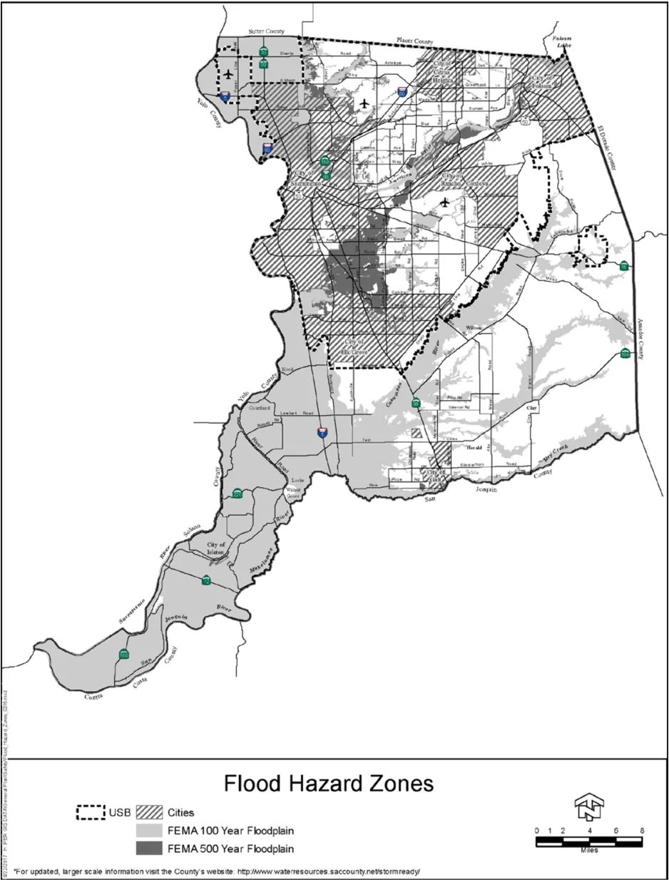
Fire Hazards
Section titled “Fire Hazards”Urban and rural fires are another type of hazard which the County may be exposed to. However, Sacramento County is much less vulnerable to major wildland fires, especially in contrast to surrounding counties that do not share its relatively flat topography and policies which limit urbanization of wildland areas. Wildfires can of course still be caused by lightning, arson, or carelessness, especially in the less developed portions of the County. Areas such as the American River Parkway and the grasslands in the east portion of the County are particularly vulnerable, and as such preventions and policies have been put in place.
Minimize the loss of life, injury, and property damage due to fire hazards.
Policies:
Section titled “Policies:”SA-23.
Section titled “SA-23.”The County shall require that all new development meets the local fire district standards for adequate water supply and pressure, fire hydrants, and access to structures by firefighting equipment and personnel.
SA-24.
Section titled “SA-24.”The County shall require, unless it is deemed infeasible to do so, the use of both natural and mechanical vegetation control in lieu of burning or the use of chemicals in areas where hazards from natural cover must be eliminated, such as levees and vacant lots.
SA-25.
Section titled “SA-25.”The County shall work with local fire districts to develop high visibility fire prevention programs, including those which provide voluntary home inspections and awareness of home fire prevention measures.
SA-26.
Section titled “SA-26.”The County and fire districts shall develop programs to provide citizens with selfpreparedness and community readiness skills for large or extended accidental, natural, and terrorist emergencies/incidents.
SA-27.
Section titled “SA-27.”The County shall require, where appropriate, the use of fire resistant landscaping and building materials for new construction developments that are cost effective.
SA-28.
Section titled “SA-28.”The County shall encourage and require, to the maximum extent feasible, automatic fire sprinkler systems for all new commercial and industrial development to reduce the dependence on fire department equipment and personnel.
SA-29.
Section titled “SA-29.”The County and fire districts will work together to regulate hazardous materials to mitigate emergency responses.
SA-30.
Section titled “SA-30.”The County, medical community, and fire districts shall work to improve EMS response system that includes first responder emergency care and transportation services.
- Properly locating resources to provide timely response
- Paramedic services from every fire station
Implementation Measures
Section titled “Implementation Measures”- The County shall request the Fire Advisory Board to propose measures that will assist in the prevention of fire in new and existing structures throughout the County. (FIRE ADVISORY BOARD)
- The County, fire districts, and the public should explore and develop standards for property development to reduce the cost of automatic fire sprinkler systems to developers and the end user who will live in these units. ( BUILDING PERMITS & INSPECTION, COUNTY ENGINEERING )
Emergency Response
Section titled “Emergency Response”Land use decisions can greatly affect the implementation of emergency response and evacuation plans in a major disaster. Road networks which have been poorly planned, do not have regular maintenance, or are not designed to accommodate population densities and growth, can severely hinder the ability of emergency response personnel from delivering supplies into an area or move people out in a timely manner. Additionally, evacuation difficulties and loss of life and property are increased when high density developments or other sensitive land uses are allowed near facilities where major disasters are more likely to occur, such as tank farms, airports, deep floodplains, or railyards. An adequate circulation network and careful land use planning, which balances the potential for disaster with economic development equally, are key to saving lives and minimizing property damage.
The Sacramento County Local Hazard Mitigation Plan forms the foundation for the community’s long-term strategy to reduce disaster losses by breaking the repeated cycle of disaster damage and reconstruction. The Local Hazard Mitigation Plan for Sacramento County is hereby incorporated by reference in to this General Plan.
An Emergency Preparedness System that can effectively respond in the event of a natural or manmade disaster.
Policies:
Section titled “Policies:”SA-31.
Section titled “SA-31.”The County shall continue to maintain, periodically update, and test the effectiveness of its Emergency Response Plan.
SA-32.
Section titled “SA-32.”The County will implement the Local Hazard Mitigation Plan in the planning and operations of the County to achieve the goals, objectives, and actions of the County’s Local Hazard Mitigation Plan.
SA-33.
Section titled “SA-33.”The County shall continue its coordinative efforts, including evacuation planning, with service agencies, the cities within the County, and cities within surrounding counties.
SA-34.
Section titled “SA-34.”The County shall increase its efforts to inform and educate the general public of disaster response and emergency preparedness procedures.
SA-35.
Section titled “SA-35.”The County shall ensure that the siting of critical emergency response facilities such as hospitals, fire, sheriff’s offices and substations, and other emergency service facilities and utilities have minimal exposure to flooding, seismic and geological effects, fire, and explosions.
SA-36.
Section titled “SA-36.”The County shall require that high intensity land uses proposed in areas highly susceptible to multiple hazards, such as the Delta, provide mitigation measures that include emergency evacuation routes. Consideration shall be given to the need for additional roads, particularly in the Delta, that may serve as evacuation routes. The County Regional Emergency Operations Office has a study of evacuation routes for various levee breach scenarios for reaches of the Sacramento River north of Freeport and for the American River.
SA-37.
Section titled “SA-37.”The County shall continue to maintain its response to flood emergencies by maintaining and updating the following:
- Flood Emergency Action Plan, to address potential flooding in levee and dam inundation areas, consistent with the California Water Code, and;
- Community flood evacuation and rescue maps, making them available to the public, as appropriate. (Added 2016)
Implementation Measures
Section titled “Implementation Measures”- The County shall continue to provide a high visibility promotional program to inform the general public of disaster response and emergency preparedness procedures. (OFFICE OF EMERGENCY SERVICES)
- The County shall revise its zoning designations to include zones not suitable for essential services due to potential hazards. (PLANNING & ENVIRONMENTAL REVIEW)
Appendix (Modified 2016)
Section titled “Appendix (Modified 2016)”The following information is provided as a part of this General Plan, in compliance with the subsections of California Government Code Section 65302(g)(2)(A):
- Flood Hazard Zones: Map is included in Safety Element, Figure 1.
- Floodplain Map: Map is included in Safety Element Background, Figure III-3.
- US Army Corps of Engineers Flood Hazard Information: Information is available from the FEMA Flood Map Service Center (MSC).
- Designated Floodway Map: Map is included in Safety Element Background, Figure III-4.
- Dam Failure Inundation Map: Text is provided in Safety Element Background, Page 39, and map is included in Safety Element Background, Figure III-10.
- Awareness Flood Plain Map: Map is included in Safety Element Background, Figure III-5.
- Levee Protection Zones: Maps are included in Safety Element Background, Figure III-7 and Figure III-8.
- Project and Non-project Levee or Floodwall Failure Inundation Map: Map is included in Safety Element Background, Figure III-11.
- Historical Data on Flooding: Text is provided in Safety Element Background, starting on Page 21, and map is included in Safety Element Background, Figure III-2.
- Existing and Planned Development in Flood Hazard Zones: Map is included in Safety Element Background, Figure III-9.
- Local, State and Federal Agencies with Responsibility for Flood Protection: The following agencies participate in flood-related data collection, planning and construction, and emergency response:
Local and Regional
- Sacramento County Department of Water Resources
- Sacramento County Office of Emergency Services (OES)
- American River Flood Control District (ARFCD)
- Sacramento Area Flood Control Agency (SAFCA)
State of California
- California Department of Water Resources (CADWR)
- Central Valley Flood Protection Board (CVFPB)
Federal
- Federal Emergency Management Agency (FEMA)
- California-Nevada River Forecast Center (CNRFC)
Reclamation Districts: Information on Reclamation Districts is available at the Local Agency Formation Commission’s (LAFCo) webpage. Reclamation Districts are as follows:
| District Name | District Number |
|---|---|
| Grand Island | RD 3 |
| Lower Andrus Island | RD 317 |
| Sherman Island | RD 341 |
| Sutter Island | RD 349 |
| Libby McNeil | RD 369 |
| Andrus Island | RD 407 |
| Pierson District | RD 551 |
| Walnut Grove | RD 554 |
| Upper Andrus Island | RD 556 |
| Tyler Island | RD 563 |
| (South of Freeport) | RD 744 |
| Randall Island | RD 755 |
| Cosumnes River | RD 800 |
| Ehrhardt Club | RD 813 |
| Natomas | RD 1000 |
| Glanville Tract | RD 1002 |
| Twitchell Island | RD 1601 |
| Brannan Island | RD 2067 |
| McCormack Williamson Tract | RD 2110 |
| Deadhorse Island | RD 2111 |