Casitas Manzanitas (Unit 1-6) PD
Adopted January 21, 1970
70-PD-1
Adopted by ZMA #3813
SECTION 1
Section titled “SECTION 1”Section 2 of Ordinance No. 534, as amended, is hereby amended to change the zoning classification of the real property described in Exhibit “A” to the R-2A (PD) Multiple Family Residential Zone (PD).
SECTION 2
Section titled “SECTION 2”Exhibits “B” through “G” inclusive, attached hereto, are incorporated and made a part of this Ordinance to regulate the property described in Exhibit “A”. The Exhibits are on file in the Office of the Clerk of the Board of Supervisors and are part of this Ordinance as if fully set forth herein.
SECTION 3
Section titled “SECTION 3”During the public hearings on this Ordinance the Planning Commission and the Board of Supervisors determined that:
- The proposed development will carry out the intent of the General Plan.
- The proposed development is of sufficient size and is designed so as to provide a desirable environment within its own boundaries.
- The proposed development is compatible with existing and proposed land uses in the surrounding area.
- Exceptions to the standard requirements of the Basic Zoning Ordinance are justified by the design of the development.
- The arrangement of dwellings and mixing of dwelling types is justified by larger and more usable open spaces.
- There is adequate assurance that all public improvements will be installed at the scheduled times as required by the Public Works Department.
- There is adequate assurance that the development schedule will be met.
- The existing or proposed utility services are adequate for the uses and population densities proposed.
SECTION 4
Section titled “SECTION 4”The number of dwelling units in any dwelling unit group as shown on Exhibit “B” shall not exceed eight (8) dwelling units.
SECTION 5
Section titled “SECTION 5”It is the intent of the Board of Supervisors to permit flexibility in the arrangement and types of apartments within the dwelling unit groups shown on Exhibit “B”. For the purpose of this ordinance and to carry out this legislative intent, the developer may construct any of the dwelling units described in Exhibits “C”, “D”, and “E” within any dwelling unit group provided that:
- The number of dwelling unit groups remains the same as shown on Exhibit "B".
- The number of dwelling units within each dwelling unit group remains the same or is less than shown on Exhibit "B".
- The percentage of parking spaces, roads, living area, and common area conforms to the data shown on Exhibit "B".
- The units identified with the red "X" on Exhibit "B" shall be one (1) story in height.
SECTION 6
Section titled “SECTION 6”The common area which includes the area for park purposes is to be governed by an involuntary Home Owners Association. The common area shall be substantially as indicated on Exhibit “B”. The property description for the common area shall be submitted to the Planning Commission at the time the subdivision map for the development is submitted to the County.
SECTION 7
Section titled “SECTION 7”Parking areas shall be constructed and maintained as shown on Exhibit “B”. Parking areas shall not be converted to other uses.
SECTION 8
Section titled “SECTION 8”The sequence of completion of the phases shown on Exhibit “B” shall be as follows:
- Phase A
- Phase B
All of the sub-phases of Phase “A” shall be completed before the commencement of construction in Phase “B”. The Board of Supervisors realizes that the construction of dwelling unit groups of this type depends on many factors such as weather, financing, and the labor market among others. The Board of Supervisors delegates to the Planning Commission the authority to change the sequence of completion of the phases and sub-phases above if evidence is submitted to the Commission of the need for change.
SECTION 9
Section titled “SECTION 9”The minimum setback from public street rights-of-way and property lines shall be as follows:
- For the unnamed North-South street the minimum setback to the nearest point of any structure shall be fifteen (15) feet.
- For the unnamed East-West street the minimum setback to the nearest point of any structure shall be twelve and one-half (12½) feet.
- The setback along the Northern property line for the property described in Exhibit "A" shall be fifteen (15) feet to the nearest point of any structure except that the setback to the nearest point of any structure shall be not less than seven and one-half (7½) feet for the Westerly four hundred eighty (480) feet along said Northern property line.
- From the property line on the East side of the property, the setback of the property described in Exhibit "A" to the nearest point of any structure shall be fifteen (15) feet.
- From Manzanita Avenue and Coyle Avenue, the setback to the nearest point of any structure shall be twenty-five (25) feet. The yard areas between the structures and the right-of-way for Manzanita Avenue and Coyle Avenue shall be landscaped.
SECTION 10
Section titled “SECTION 10”The following uses for the property described in Exhibit “A” are prohibited:
- The parking and/or storage of commercial, industrial or agricultural motor vehicles or trailers rated more than one (1) ton capacity.
- Storage yards, storage buildings, garages, carports, and similar accessory buildings except as otherwise shown on exhibits.
- Patio awnings except on patios which adjoin the parking areas.
The Articles of Incorporation and the Bylaws which establish and regulate the Home Owners Association and the covenants, conditions, and restrictions which regulate the common area of the property described in Exhibit “B” are incorporated into this Ordinance by reference. The uses described in the covenants, conditions, and restrictions shall regulate the property in Exhibit “A” by the terms of this Ordinance as if said uses are enumerated herein.
SECTION 11
Section titled “SECTION 11”Street improvements shall be as called for by the Subdivision Ordinance and the dedication of said streets shall be made on the recording of the Subdivision Map.
SECTION 12
Section titled “SECTION 12”All utilities shall be underground.
SECTION 13
Section titled “SECTION 13”Violation of the provisions of this Ordinance or Exhibits made part of this Ordinance shall be deemed a violation of the Basic Zoning Ordinance, Ordinance No. 534, as amended.
EXHIBIT A
Section titled “EXHIBIT A”All that certain real property situate in the County of Sacramento, State of California, described as follows:
All that portion of Section 4, Township 9 North, Range 6 East, M.D.M., described as follows:
Beginning at the Northwest corner of the Northeast quarter of said Section 4, said corner also being a point in the East line of Rancho Del Paso, the official plat of which is recorded in the office of the Recorder of Sacramento County in Book 11 of Surveys, Map No. 94; thence from said point of beginning, along the North line of said Section 4, North 87°56’16” East 1269.01 feet to the Northwest corner of “Merrihill North Unit No. 1,” filed in the office of the Recorder of Sacramento County in Book 57 of Maps, Map No. 9; thence along the Westerly boundary of said Merrihill North Unit No. 1, the following six (6) courses:
- South 09°52’30” East 251.15 feet
- South 10°44’50” West 101.85 feet
- South 26°06’40” West 145.67 feet
- South 13°31’00” West 149.22 feet
- South 01°10’30” West 144.92 feet, and
- South 02°03’10” East 248.00 feet, to a point in the centerline of Coyle Avenue; thence along the centerline of said Coyle Avenue, South 87°56’50” West 586.25 feet; thence at right angles to said centerline of Coyle Avenue, North 02°03’10” West 612.89 feet; thence parallel with said centerline of Coyle Avenue, South 87°56’50” West 586.33 feet to a point in said East line of Rancho Del Paso; thence along said East line of Rancho Del Paso, North 00°46’30” West 400.00 feet to the point of beginning; containing 20.317 acres, more or less.
EXHIBIT B
Section titled “EXHIBIT B”
EXHIBIT C
Section titled “EXHIBIT C”
EXHIBIT D
Section titled “EXHIBIT D”
EXHIBIT E
Section titled “EXHIBIT E”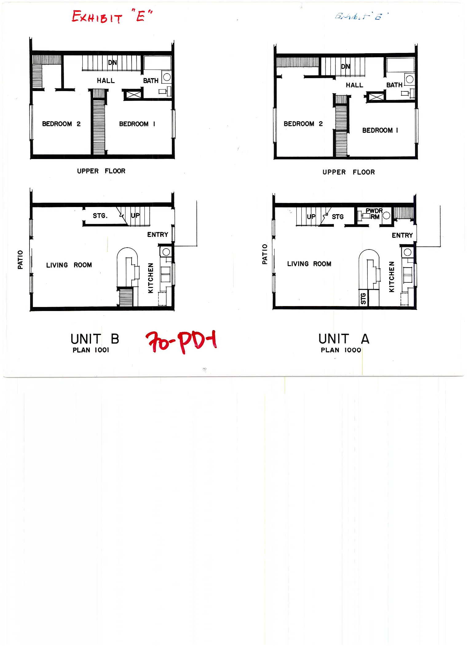
EXHIBIT F
Section titled “EXHIBIT F”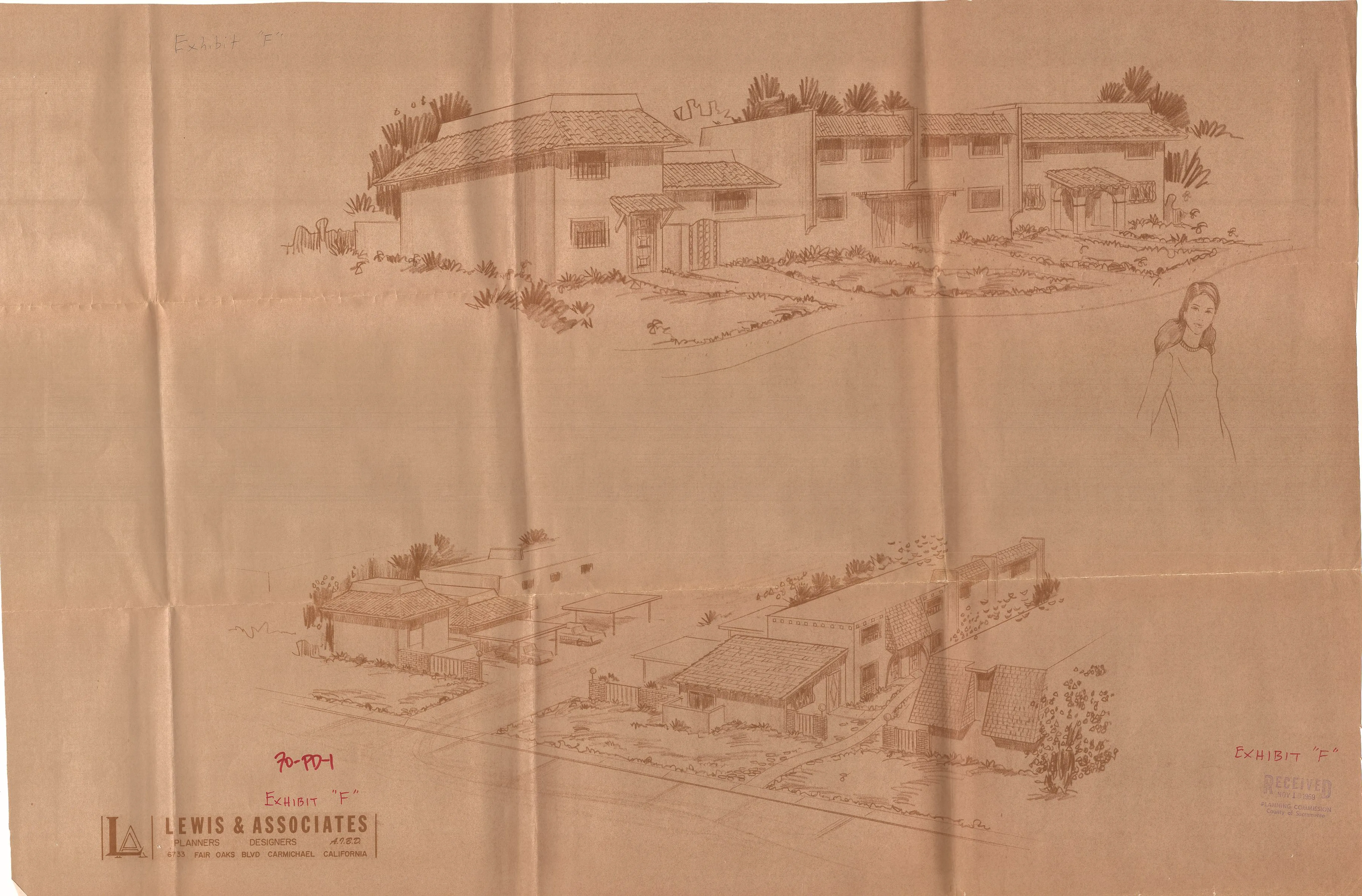
EXHIBIT G
Section titled “EXHIBIT G”