Wilhaggin Lake Estates PD
Sacramento County Zoning Code
Wilhaggin Lakes Estates Planned Development Ordinance
Section titled “Sacramento County Zoning Code Wilhaggin Lakes Estates Planned Development Ordinance”Adopted April 10, 1974
Amended September 9, 1987
74-PD-4
Adopted by ZMA #3271
Amended by Ordinance 74-PD-4A
SECTION 1.
Section titled “SECTION 1.”Section(s) 23.01.161 and 23.01.162 of the Zoning Code of Sacramento County, Ordinance No. 1111, which incorporates Comprehensive Zoning Plan(s), Unit(s) No. 324/176 and 332/176 are amended to change the real property described in Exhibit “A” on said Comprehensive Zoning Plan to RE-2 (PD) Rural Estate (Planned Development) Zone. Exhibit “A” is attached hereto and incorporated herein and made a part of this ordinance.
SECTION 2.
Section titled “SECTION 2.”Article 3 of the Zoning Code of Sacramento County is hereby amended by adding thereto Section 23.01.151, which shall read as follows:
23.01.151 – Planned Unit Development Ordinance 74-PD-4
SECTION 3.
Section titled “SECTION 3.”[AMENDED 09-09-1987]
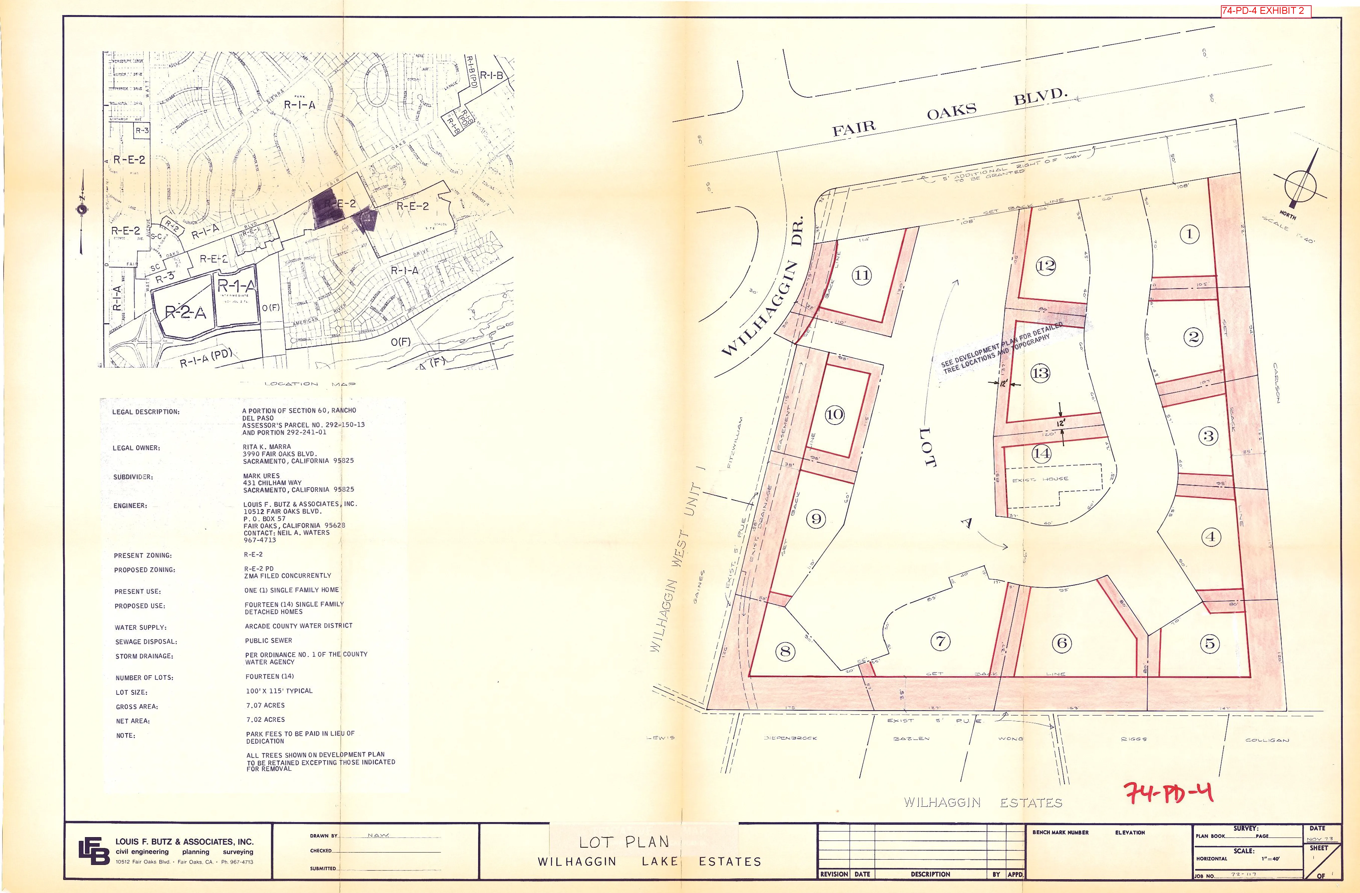
Exhibits 1, 2 and B inclusive, described generally in this section and attached to this ordinance are incorporated herein and made a part of this ordinance to regulate the property described in Exhibit “A”. The exhibits are on file in the office of the Clerk of the Board of Supervisors and are a part of this ordinance as if fully set forth therein.
EXHIBITS:
- Development Plan
- Lot Plan
- Lot “6” Site Plan
SECTION 4.
Section titled “SECTION 4.”The following uses are authorized on the property described in Exhibit “A”. None of the common area shall be converted to any use other than for the private recreational uses of the owners, residents and guests. All uses not specifically named are prohibited.
- One (1) Single Family Detached Dwelling on each lot;
- Foster Homes not to exceed six children, including children of the foster family;
- Accessory uses customarily incidental to and subordinate to the principal use of the premises;
- Temporary construction yard and buildings pursuant to Section 23.14.012 of the Zoning Code;
- Signs offering individual dwelling units "for rent" or "for sale", provided: The total area of each sign is no more than four square feet; The sign shall not be illuminated; no more than one such sign shall be placed on each lot;
- Temporary signs identifying architects, landscape architects, contractors.
SECTION 5. Single Family Detached Dwellings.
Section titled “SECTION 5. Single Family Detached Dwellings.”[AMENDED 09-09-1987]
The existing residence on lot 14 as shown on Exhibits “1” and “2” may remain. Single Family detached dwellings shall be constructed on lots numbered 1 through 13 inclusive, as set forth on Exhibits “1” and “2”, subject to the following provisions:
- The dwellings on lots 5, 7, 8, 9, 10, 11, as set forth on Exhibits "1" and "2" shall not exceed one story in height;
- The dwellings on lots numbered 1, 2, 3, 4, 6, 12, and 13 as set forth on Exhibits "1" and "2" shall not exceed two stories in height. The second story addition of Lot 6 shall not vary from the location nor exceed the area identified on Exhibit B, and no openings are permitted facing the south and west.
- No building shall be placed in that area shaded in red as shown on Exhibit "2";
- The height limit of any proposed dwelling, building, structure or pole shall not exceed thirty (30) feet in height;
- All garages are to be constructed at a setback minimum of not less than twenty-five (25) feet from the edge of the private street as shown on Exhibit "1";
- Fencing is permissible on all lots, subject to the following:
- No fencing shall be constructed within thirty (30) feet as measured from the back of a curb of any private street as shown on Exhibit "1";
- Fencing is permissible along the exterior boundary of the project as shown in Exhibit "1"; provided that any wall, fence or other visual obstruction along the north boundary of the project shall not be permitted unless shown in the approved landscaping plan as provided herein;
- Fencing is permissible on the west side of lots 12 through 14, and on the east side of lots 9 through 11, and on all lots mentioned herein shall be of a non-solid type.
SECTION 6. Streets.
Section titled “SECTION 6. Streets.”The location, configuration and arrangement of the streets shall be as shown on Exhibit “1”. All streets in the project shall be at least as wide as shown on Exhibit “1” and sufficiently maintained so as to allow passage for fire trucks and other emergency vehicles. The minimum allowable thickness of the roadbed sections of the streets shall be as provided in Section 11.09.1 of the County Improvements Standards adopted by Resolution No. 66-1048 of the Board of Supervisors of the County of Sacramento, and amendments thereto, which establish the allowable thickness for 42 foot wide streets, and the maximum allowable grade exchange in the profile of streets shall be eight percent (8%). The vertical clearance between the finished surface of the streets and any wires, lights, poles, tree limbs or other obstructions shall not be less than twelve (12) feet. At the intersection of any private street with any public street there shall be a curb return of not less than a 20 foot radius. For the purpose of this section private street is defined as any private street providing vehicular access to or parking for more than one (1) dwelling unit. All private streets are to be named and dwelling units are to be identified by signs showing the unit numbers and street names at locations readily visible to emergency vehicles.
SECTION 7. Parking.
Section titled “SECTION 7. Parking.”The location and configuration of parking areas shall be as shown on Exhibit “1”. The number of parking stalls within the parking areas shall be as shown on Exhibit “1”. The dimensions of the parking stalls shall conform to the parking standards set forth in Chapter 15 of the Zoning Code of Sacramento County, Ordinance No. 1111. Parking shall be permitted only on one side of the private streets shown on Exhibit “1”; the developer shall place “no parking” signs along the other side of such streets; and the Homeowners’ Association shall maintain such signs to the satisfaction of the Public Works Department. The parking or storage of commercial, industrial or agricultural motor vehicles or trailers rated more than 3/4 ton capacity is expressly prohibited, except for normal and temporary service or delivery functions within the development. All boats, trailers, recreational motor vehicles and camper bodies shall be parked or stored within enclosed garage structures. Developer is hereby put on notice that the parking facilities approved by the Board of Supervisors may in addition to any permit required by Sacramento County require a permit or other form of approval by the United States Environmental Protection Agency. Approval by the Board of Supervisors of this parking facility shall not in any manner be construed to be a representation by the said Board that the parking facility will be approved in part or in total by said Environmental Protection Agency. In the event that the Environmental Agency approves the parking facilities with less parking spaces than is approved by the Board of Supervisors, then the developer shall install only such parking spaces as is approved by the Environmental Protection Agency, but the additional spaces or areas for parking spaces otherwise required by this ordinance shall be landscaped to the satisfaction of the Parks and Recreation Department and the Planning Department.
SECTION 8. Grading.
Section titled “SECTION 8. Grading.”No grading, as defined in Chapter 16.44 of the Sacramento County Code, on the property described in Exhibit “A” shall be undertaken except in conformance with final grading plans approved by the Public Works Department and the grading permit issued by said department. No building permit for any dwelling within the property described in Exhibit “A” shall be issued until such grading plans have been approved and the grading permit issued by the Public Works Department. All grading shall be limited to that necessary to install private streets and driveways as shown on Exhibit “1”, and the normal site preparation for building sites; provided, however, no site grading shall be permitted in lots 9, 10, 11, 12 and 13 until site grading plans are approved for said lots by the Planning Department.
In the event that fill is necessary to develop lots 1, 2, 7, 8 and 12 as shown on Exhibit “1”, such fill shall not be obtained from other parts of the development. All grading within the project shall be conducted only between the months of May and September, provided that the developer may begin grading earlier than May or later than September if provisions are made for erosion control to the satisfaction of the Public Works Department.
SECTION 9. Landscaping Plan
Section titled “SECTION 9. Landscaping Plan”Prior to the construction of any building described in Exhibit “A”, the developer shall submit to the Parks and Recreation Department for approval a landscaping plan which shall show landscaping details of the common area designated as Lot “A” on Exhibit “2”. Said landscaping plan shall include provisions for the proper care and maintenance of the lake within the development, including provisions for the proper and adequate circulation of the lake water and the protection of the lake from street runoff. Such provisions for the proper care and maintenance of the lake as provided in said landscaping plan shall also be submitted to the Sacramento County Health Agency for approval.
SECTION 10. The Homeowners’ Association
Section titled “SECTION 10. The Homeowners’ Association”The Homeowners’ Association shall maintain all the common area designated as Lot “A” on Exhibit “2”. The Articles of Incorporation and Bylaws of the Homeowners’ Association, the prospective owner of the common area, and the Declaration of Covenants, Conditions and Restrictions shall be approved by the County Counsel prior to the issuance of the building permit for any dwelling unit. The Declaration of Covenants, Conditions and Restrictions, the Articles of Incorporation and the Bylaws shall provide that the same may not be amended without the concurring approval of the County of Sacramento. The documents shall also provide that the County of Sacramento shall be able to enforce the provisions of the documents which relate to the maintenance of structures, joint use facilities and the common open space and the lake.
SECTION 11. Insubstantial Deviations
Section titled “SECTION 11. Insubstantial Deviations”The Board of Supervisors recognizes that in construction of the project minor deviations from the location and configuration of the project as shown on Exhibits “1” and “2” may occur. The Board, having considered this possibility, has determined that “insubstantial deviations” from Exhibits “1” and “2” do not constitute an amendment to the plan. Insubstantial deviations in locations of the streets or property lines of up to five (5) feet from locations shown on Exhibits “1” and “2” shall be permitted. The Board of Supervisors delegates to the Zoning Administrator the authority to permit deviations in the locations of the streets or property lines of over five (5) feet, but less than twenty (20) feet from the locations shown on Exhibits “1” or “2” if the Zoning Administrator determines that such adjustments do not reduce or diminish the quality of the development; provided, however, that the Zoning Administrator shall not permit an increase in the number of dwelling units or a decrease in the amount of open area as shown on Exhibits “1” or “2”.
SECTION 12. Subdivision Map
Section titled “SECTION 12. Subdivision Map”Developer and/or the owners shall record a subdivision map of the property described on Exhibit “A”.
SECTION 13. Variances
Section titled “SECTION 13. Variances”The variance provision of Article 1, Chapter 18 of the Sacramento County Zoning Code, Ordinance No. 1111, shall not apply to this ordinance.
SECTION 14. Violation
Section titled “SECTION 14. Violation”Violation of the provisions of this ordinance or exhibits made part of this ordinance shall be deemed a violation of the Sacramento County Zoning Code, Ordinance No. 1111.
SECTION 15. Findings
Section titled “SECTION 15. Findings”During the public hearings on this ordinance the Planning Commission and the Board of Supervisors determined that:
- The proposed development will carry out the intent of the General Plan;
- The proposed development is of sufficient size and is designed so as to provide a desirable environment within its own boundaries;
- The proposed development is compatible with existing and proposed land uses in the surrounding area;
- Exceptions to the standard requirements of the Sacramento County Zoning Code, Ordinance No. 1111, are justified by the design of the development;
- The arrangements of dwellings and mixing of dwelling types is justified by larger and more usable open spaces;
- There is adequate assurance that all public improvements will be installed at the scheduled times as required by the Public Works Department;
- There is adequate assurance that the development schedule will be met;
- The existing or proposed utility services are adequate for the uses and population densities proposed.
EXHIBIT “A”
Section titled “EXHIBIT “A””PARCEL 1
Section titled “PARCEL 1”All that portion of Section 60, as shown on the “Map of Survey and Subdivision of Rancho Del Paso”, recorded in the office of the Recorder of Sacramento County, California, on March 4, 1911, in Book A of Surveys, Map No. 94, described as follows:
BEGINNING at a point on the Northerly boundary of that certain 2206.81 acre tract of land described in deed executed by Rancho Del Paso Land Company to W. E. Gerber and W. A. Curtis, dated October 19, 1910, and recorded in the office of the County Recorder of the Sacramento, in Book 317 of Deeds, page 559, from which the corner common to Sections 58, 59, 60 and 61 of said Rancho Del Paso bears North 67°52’30” East 614.11 ft. to a concrete monument; thence North 68°46’00” East 832.40 ft. to a concrete monument; thence North 61°35’00” East 331.50 ft.; and thence North 01°49’00” West 1096.72 ft.; thence from said point of beginning South 67°52’30” West 613.60 ft. along the Northerly boundary of said 2206.81 acre tract; thence North 08°06’40” West 570.51 ft. to a point on the South line of Fair Oaks Boulevard; thence North 57°45’30” East 430.31 ft. along said South line; thence South 26°50’00” East 631.23 ft. to the point of beginning.
PARCEL 2
Section titled “PARCEL 2”All that portion of Lot 3, as shown on the official “Plat of Wilhaggin West, Unit No. 1” recorded in the office of the County Recorder of the County of Sacramento, State of California, in Book 60 of Maps, Map No. 3, described as follows:
BEGINNING at a point from which the northwest corner of said Lot 3 bears North 06°46’00” West 0.15 ft. and South 59°14’45” West 20.71 ft; thence along the west line of that certain property described in Book 68-07-16 Official Records, at Page 68, South 06°46’00” East 162.42 ft.; thence North 76°18’11” West 20.51 ft. to a point in the west line of said Lot 3 and the east line of Wilhaggin Drive, a County road 60.00 ft. in width; thence along said line and along the arc of a curve to the left having a radius of 180.00 ft., the chord of which bears North 03°09’23” West 126.65 ft.; thence along the arc of a curve to the right having a radius of 25.00 ft., the chord of which bears North 14°30’47” East 30.97 ft. to the point of beginning and containing 1290 square feet.
EXHIBIT B
Section titled “EXHIBIT B”[ADDED 09-09-1987]
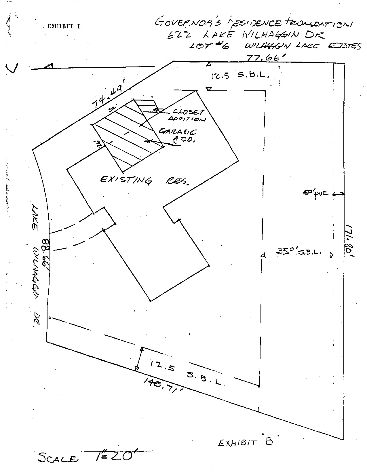
EXHIBIT 1
Section titled “EXHIBIT 1”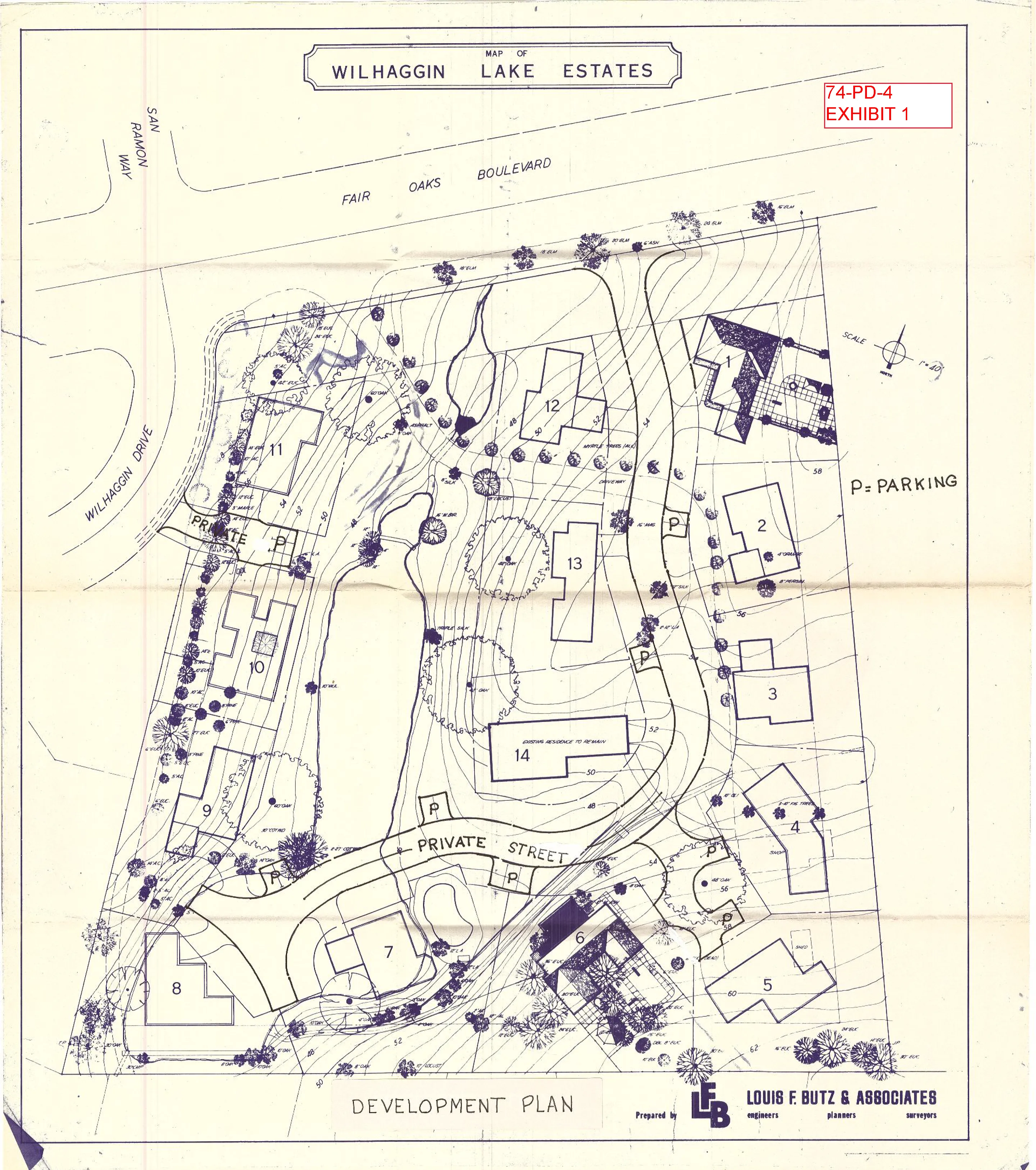
EXHIBIT 2
Section titled “EXHIBIT 2”