Sunrise Hills PD
Sacramento County Zoning Code
Sunrise Hills Planned Development Ordinance
Section titled “Sacramento County Zoning Code Sunrise Hills Planned Development Ordinance”Adopted February 26, 1975
75-PD-1
Adopted by ZMA #3373
SECTION 1. ZONE
Section titled “SECTION 1. ZONE”Section 23.01.185 of the Zoning Code of Sacramento, Ordinance No. 1111, which incorporates Comprehensive Zoning Plan No. 356/212 is amended to change the real property described in Exhibit “A” on said Comprehensive Zoning Plan to the RE-1 (PD) Estate (Planned Development) Zone. Exhibit “A” is attached hereto and incorporated herein and made a part of this ordinance.
SECTION 2. AMENDMENT
Section titled “SECTION 2. AMENDMENT”Article 3 of the Zoning Code of Sacramento County, Ordinance No. 1111, is hereby amended by adding thereto Section 23.01.342, which shall read as follows:
23.01.342 – Planned Unit Development Ordinance 75-PD-1
SECTION 3. EXHIBITS
Section titled “SECTION 3. EXHIBITS”Exhibit “1” is described generally in this section and attached to this ordinance and is incorporated herein and made a part of this ordinance to regulate the property described in Exhibit “A”. The Exhibit is on file in the Office of the Clerk of the Board of Supervisors and is a part of this ordinance as if fully set forth herein.
EXHIBITS:
- Development Plan
SECTION 4. USES
Section titled “SECTION 4. USES”The following uses are authorized on the property described in Exhibit “A”. All uses not specifically named are prohibited.
- One (1) Single Family detached dwelling on each lot.
- Accessory buildings appurtenant to a permitted use which are incidental to and subordinate to the principal use of the premises. Such accessory buildings shall be located in the buildable portion of the lot.
- Accessory uses customarily incidental to and subordinate to the principal use of the premises.
- Foster homes not to exceed 6 children.
- Day care homes not to exceed 10 children.
- Real Estate signs advertising the particular property on which the sign is located as provided in Section 23.16.000 of the Zoning Code.
- Temporary construction signs as provided in Section 23.16.001 of the Zoning Code.
- Political, religious and civic campaign signs as provided in Section 23.16.001 of the Zoning Code.
- Subject to the issuance of a conditional use permit by the Zoning Board of Adjustment, one mobilehome or travel trailer may be used as an accessory dwelling where there is a need for close supervision of the occupants of the mobile home or travel trailer by the occupants of the principal dwelling subject to conditions of Section 23.14.021 of the Zoning Code.
SECTION 5. SINGLE FAMILY DETACHED DWELLINGS
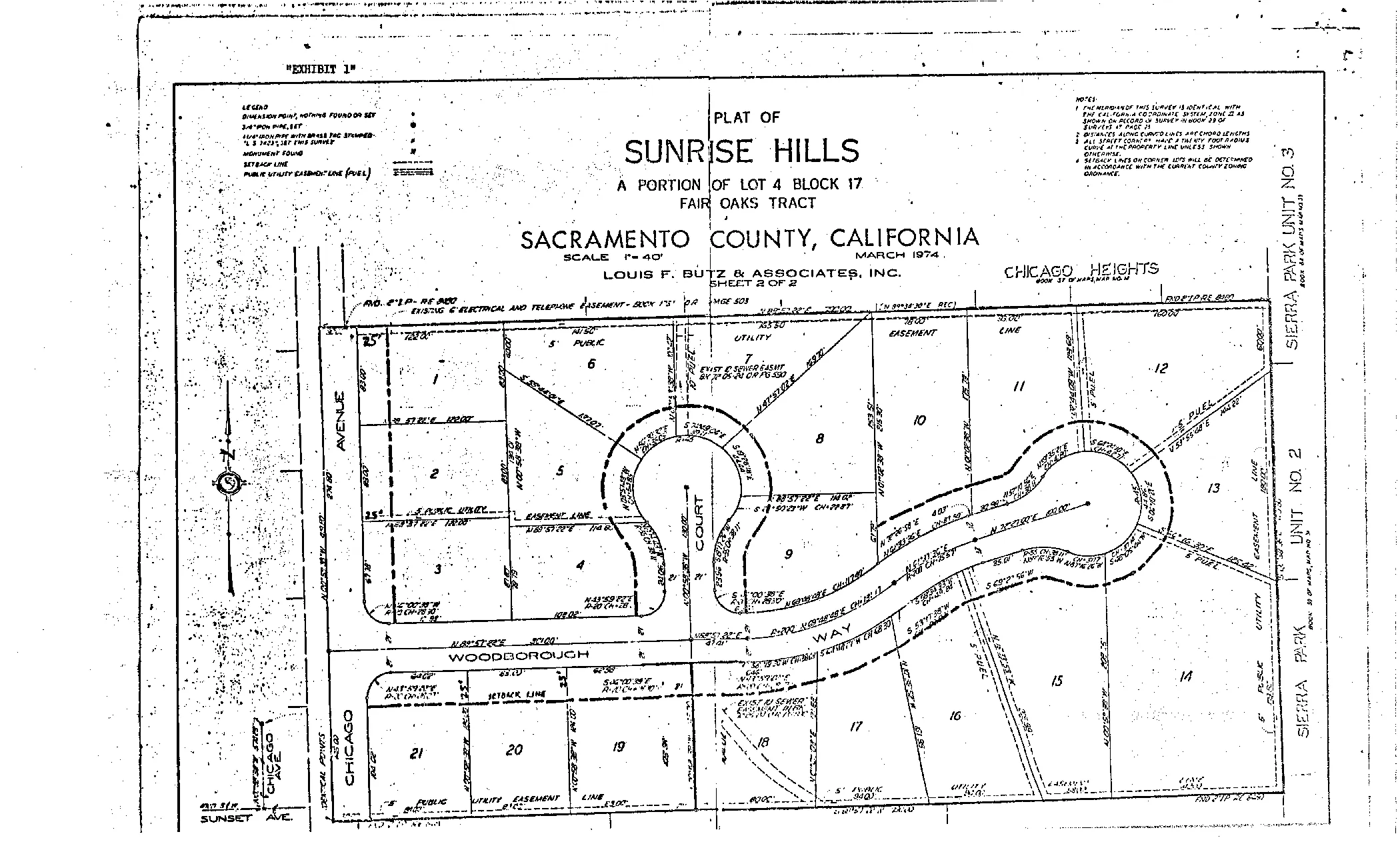
Section titled “SECTION 5. SINGLE FAMILY DETACHED DWELLINGS”The number of lots in the project shall be as shown on Exhibit “1”. The size and shape of each lot in the project shall be as shown for each lot on Exhibit “1”. One (1) single family detached dwelling shall be constructed on each lot set forth on Exhibit “1”. Site plans, floor plans, and elevations for each single family detached dwelling on each lot described in Exhibit “1” shall be submitted to the Planning Department for approval, and no building permit shall be issued for a single family dwelling until the site plan, floor plan, and elevations are so approved. The development of each lot set forth on Exhibit “1” shall conform to Sections 23.07.033, 23.07.034, 23.07.035, 23.07.036, 23.07.037 except that the yard requirements for each building or structure erected on each of the lots set forth in Exhibit “1” shall be as follows:
- Front Yard. There shall be a front yard of not less than twenty-five (25) feet.
- Rear Yard. There shall be a rear yard of not less than thirty (30) feet except if the lot is less than one hundred and fifty (150) feet in depth, the rear yard shall be twenty (20%) percent of the average lot depth to a minimum of twenty (20) feet.
- Side Yards. A side yard on each side of all buildings and structures of not less than five (5) feet for a one story building and not less than seven and one-half (7 1/2) feet for a two story building.
- Side Street Yards. On corner lots there shall be a side street yard of not less than twelve and one-half (12 1/2) feet for all single family detached dwellings and their accessory buildings. All other buildings shall provide side street yards of not less than twenty-five (25) feet.
SECTION 6. STREETS
Section titled “SECTION 6. STREETS”The location, configuration, and arrangement of streets shall be as shown on Exhibit “1”. In the event that the Board of Supervisors at a future date approves any changes in the location, configuration, or arrangement of streets presently shown on Exhibit “1” then this ordinance shall be construed so as to apply to such changes. All streets in the project shall be at least as wide as shown on Exhibit “1” and sufficiently maintained so as to allow passage for fire trucks and other emergency vehicles. The minimum allowable thickness of the roadbed section of the streets shall be as provided in Section 11.09.1 of the County Improvement Standards adopted by Resolution No. 66-1048 of the Board of Supervisors of Sacramento County and amendments thereto which establish the allowable thickness for forty-two (42) foot wide streets, and the maximum allowable grade change in the profile of streets shall be eight (8%) percent. All streets set forth in Exhibit “1” shall be offered for dedication as public streets. The vertical clearance between the finished surface of the street and driveways and any wires, lights, poles, tree limbs, or other obstructions shall not be less than twelve (12) feet.
SECTION 7. PARKING
Section titled “SECTION 7. PARKING”The parking or storage of commercial, industrial, or agricultural motor vehicles rated more than 3/4 ton capacity for periods of time in excess of twelve (12) hours is expressly prohibited.
SECTION 8. GRADING
Section titled “SECTION 8. GRADING”No grading on the property described in Exhibit “A” shall be undertaken except in conformance with final grading plans approved by the Public Works Department and subject to a grading permit issued by said Department. No building permit shall be issued for any building or structure on the lots set forth in Exhibit “1” until any grading plan required by the provisions of this ordinance or any provision of the Sacramento County Code or the Zoning Code of Sacramento County has been approved. Prior to the issuance of any grading permit for any lot set forth on Exhibit “1”, the site plan for said lot must be approved by the Planning Department as provided in this Ordinance.
SECTION 9a. VARIANCES
Section titled “SECTION 9a. VARIANCES”The variance provision of Article 1, Chapter 18, of the Zoning Code of Sacramento County, Ordinance No. 1111, shall not apply to this Ordinance.
SECTION 10. VIOLATION
Section titled “SECTION 10. VIOLATION”Violation of the provisions of this ordinance or exhibits made part of this ordinance shall be deemed a violation of the Zoning Code of Sacramento County, Ordinance No. 1111.
SECTION 11. FINDINGS
Section titled “SECTION 11. FINDINGS”During the public hearing on this ordinance, the Planning Commission and the Board of Supervisors determined that:
- The proposed development will carry out the intent of the general plan.
- The proposed development is of sufficient size and is designed so as to provide a desirable environment within its own boundaries.
- The proposed development is compatible with existing and proposed land uses in the surrounding area.
- Exceptions to the standard requirements of the Sacramento County Zoning Code, Ordinance No. 1111, are justified by the design of the development.
- There is adequate assurance that all public improvements will be installed at the scheduled times as required by the Public Works Department.
- The existing or proposed utility services are adequate for the uses and population densities proposed.
EXHIBIT “A” – SUNRISE HILLS PLANNED DEVELOPMENT
Section titled “EXHIBIT “A” – SUNRISE HILLS PLANNED DEVELOPMENT”Assessor’s Parcel No. 246-023-07
Beginning at the southeast corner of Chicago Heights Subdivision; running thence westerly along the southerly boundary of said Chicago Heights Subdivision 770 feet more or less to the easterly Right-of-way line of Chicago Avenue; thence southerly along said easterly Right-of-way line of Chicago Avenue 420 feet more or less to a point located northerly 577.09 feet from the centerline of Sunset Avenue; thence N. 89°34’30” E. 770 feet more or less to the westerly boundary line of Sierra Park Unit No. 2 Subdivision; thence northerly along said westerly boundary of Sierra Park Unit No. 2 Subdivision and the westerly boundary of Sierra Park Unit No. 3 Subdivision 420 feet more or less to the point of beginning.
EXHIBIT 1
Section titled “EXHIBIT 1”