Curragh Oaks PD
Sacramento County Zoning Code
Curragh Oaks Planned Development Ordinance
Section titled “Sacramento County Zoning Code Curragh Oaks Planned Development Ordinance”Adopted November 10, 1976
76-PD-08
Adopted by ZMA #3580
SECTION 1. PROPERTY REZONED
Section titled “SECTION 1. PROPERTY REZONED”Sections 23.01.184, 23.01.185, and 23.01.189 of the Zoning Code of Sacramento County, Ordinance No. 1111, as amended, which incorporates Comprehensive Zoning Plans Units No. 348/212, 356/212, and 356/224 respectively, is amended to change the real property described in Exhibit “A” on said Comprehensive Zoning Plan to A-1-A (PD) Agricultural (Planned Development) Zone. Exhibit “A” is attached hereto and incorporated herein and made a part of this ordinance.
SECTION 2. INCORPORATION WITHIN ZONING CODE
Section titled “SECTION 2. INCORPORATION WITHIN ZONING CODE”Chapter 11, Article 3 of the Zoning Code of Sacramento County, Ordinance No. 1111, as amended, is hereby amended by adding thereto Section 23.01.357, which shall read as follows:
Section 23.01.357 – Planned Unit Development Ordinance No. 76-PD-8
SECTION 3. EXHIBITS INCORPORATED
Section titled “SECTION 3. EXHIBITS INCORPORATED”Exhibits “1” and “2”, inclusive, described generally in this section and attached to this ordinance are incorporated herein and made a part of this ordinance to regulate the property described in Exhibit “A”. The exhibits are on file in the office of the Clerk of the Board of Supervisors, and are a part of this ordinance as if fully set forth herein.
EXHIBITS:
- Site Plan
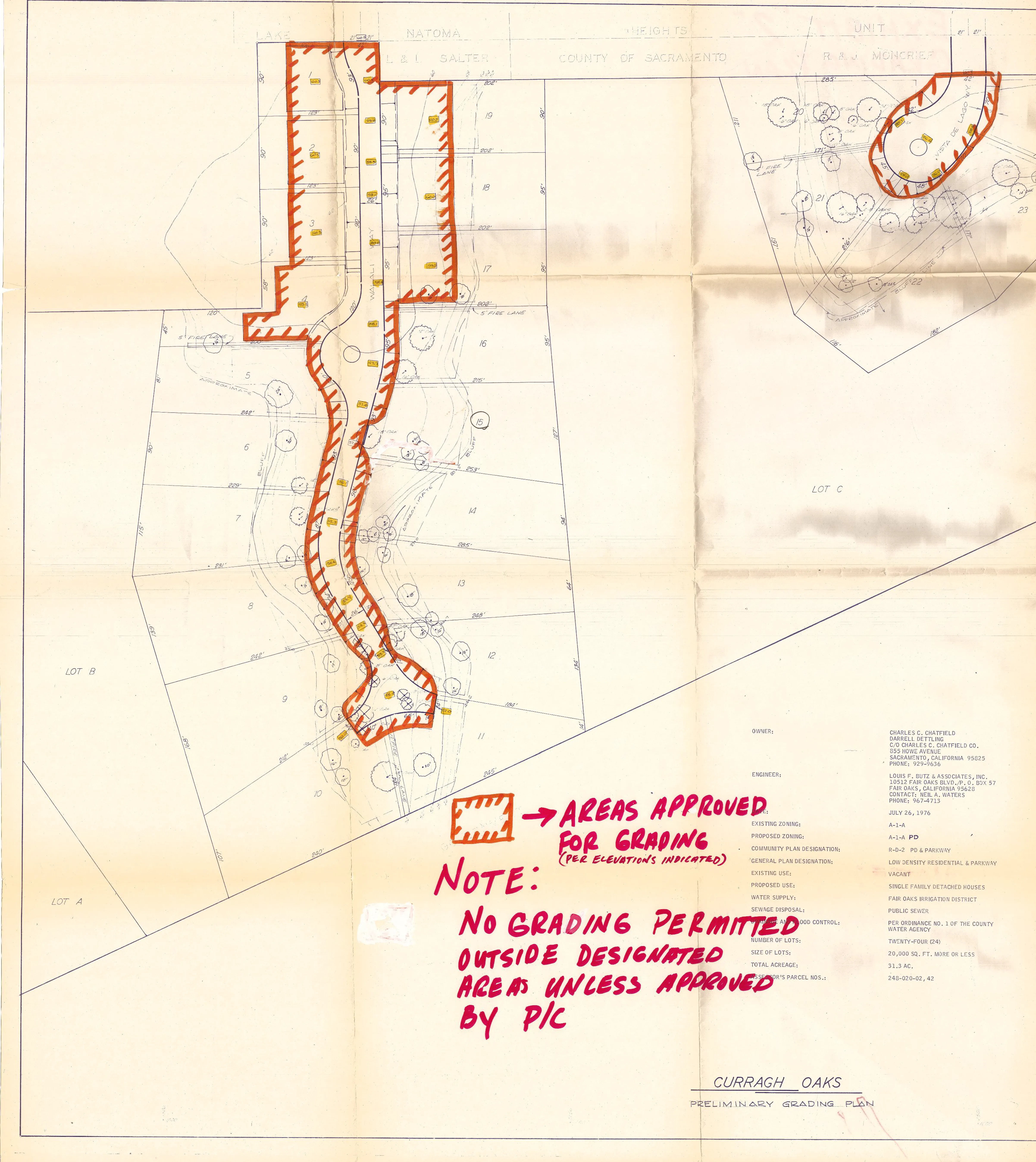
- Grading Plan
SECTION 4. PURPOSE OF ORDINANCE
Section titled “SECTION 4. PURPOSE OF ORDINANCE”The property commonly known as Curragh Oaks P.D. and more specifically described in Exhibit “A” consists of two generally level, developable areas with the remainder of the site being heavily wooded environmentally sensitive ravines. It is the purpose of this ordinance to provide flexibility in the design and development of the area in order to maximize the preservation of the unique physical and scenic characteristics of the land, while at the same time maintaining development consistent with the applicable zoning as shown on the Exhibits incorporated herein. It is also the purpose of this ordinance to provide for review and approval by the Project Planning Commission of building sites to determine the extent of tree removal and grading, for those sites which do not have designated building envelopes as indicated on Exhibit “1”.
SECTION 5. PERMITTED USES
Section titled “SECTION 5. PERMITTED USES”- One (1) single family detached dwelling on each lot.
- Accessory buildings appurtenant to a permitted use which are incidental to and subordinate to the principal use of the premises.
- Accessory uses customarily incidental to and subordinate to the principal use of the premises.
- Foster homes not to exceed 6 children including children of the foster family.
- Real estate signs as provided in Section 23.16.000.
- Temporary construction signs as provided in Section 23.16.001.
- Political, religious, and civic campaign signs as provided in Section 23.16.002.
SECTION 6. DEVELOPMENT STANDARDS
Section titled “SECTION 6. DEVELOPMENT STANDARDS”No building or structure erected on or moved onto any lot shown on Exhibit “1” with a “building envelope” shall have a height greater than two stories or greater than thirty (30) feet; nor shall such building or structure, whether principal or accessory, be constructed without providing the yard areas established by the “building envelope” lines.
No building or structure, whether principal or accessory, erected on or moved onto any lot designated on Exhibit “1” with a red “X” shall have a height greater than two stories or greater than thirty (30) feet; nor shall any building permit be issued for such building or structure until a site plan has been submitted to and approved by the Project Planning Commission.
Said site plan shall show:
- The location of existing and proposed structures and buildings.
- The location and size of existing trees.
- The location of adjacent public rights-of-way and private easements for ingress and egress, if any.
- The location of existing and proposed walls and fences; the height and the construction materials thereof.
- Finished grade of the site at the building.
- An indication of areas intended for landscaping.
- An elevation drawing of all improvements.
- Other data or materials deemed necessary by the director.
The Planning Commission should limit its review to the following:
- Location of the trees to be removed and to be retained.
- Lot grading.
- Location of improvements on the lot taking into consideration the size and configuration of the lot.
The review provided by this Section shall not render said lots undevelopable to the uses and densities established herein.
SECTION 7. GRADING
Section titled “SECTION 7. GRADING”Grading within the area indicated in orange on Exhibit “2” shall be in substantial conformance with the elevations shown on said Exhibit “2”. No grading outside of said areas shall be done during the construction of the project or during the construction of any residences, unless the site plans therefor have been approved pursuant to Section 6 above.
SECTION 8. TREE REMOVAL
Section titled “SECTION 8. TREE REMOVAL”The design, layout, and configuration of the improvements shall be accomplished so as to minimize the removal of trees. No trees shall be damaged or removed unless:
- The trees are located within the right-of-way of an approved street or approved building envelope.
- The trees are specifically approved for removal by the Planning Commission as part of the site plan approval.
SECTION 9. RESTRICTED AREAS
Section titled “SECTION 9. RESTRICTED AREAS”As shown by a dashed green line on Exhibit “A”, a restricted area shall be established on the indicated portion of the lot and shall be shown on the Final Subdivision Map, within which no structure or fence shall be constructed or placed, no trees shall be removed, and no grading or excavating shall be conducted without the consent of the County. Consent by the County shall mean written approval by the Director of the Community Development and Environmental Protection Agency, or by such other person as may be designated by said Director to give such consent. Restricted areas established hereunder shall not render a lot undevelopable to the uses and densities established herein.
SECTION 10. STREETS
Section titled “SECTION 10. STREETS”Vista Del Lago shall be offered for dedication as a public road with a right-of-way of 42 feet total width. Said public road shall be constructed in conformance with County standards adopted by Resolution No. 73-495, for Class “B” streets as defined therein. The extension of Walali Road shall be continued in the location and configuration shown on Exhibit “A” and shall be a private road. The minimum thickness of the roadbed sections of the said Walali Road shall be as provided in Section 9.03–9.01 of the County Improvement Standards adopted by Resolution No. 73-495 of the Board of Supervisors of the County of Sacramento, and amendments thereto which establish the allowable thickness for 42-foot wide streets. The widths of the private road shall not be less than as shown on Exhibit “1”. Said private road shall be sufficiently maintained so as to allow passage for fire trucks and other emergency vehicles. All private roads are to be named and dwelling units are to be identified by signs showing unit numbers, and such names and unit numbers shall be placed at locations visible to emergency vehicles. Those roads designated at the southerly end of Walali Way on Exhibit “1” as fire lanes shall be private roads at least ten (10) feet in width and sufficiently maintained and kept free of obstructions so as to allow passage for fire trucks and other emergency vehicles and to the satisfaction of the fire district having jurisdiction over said property. The vertical clearance between the finished surface of the private roadway and any wires, lights, poles, tree limbs, or other obstructions shall not be less than twelve (12) feet.
SECTION 11. SUBSEQUENT IMPROVEMENTS
Section titled “SECTION 11. SUBSEQUENT IMPROVEMENTS”The Board of Supervisors recognizes that after the development of the project has taken place, property owners and residents thereof may desire to make certain improvements, alterations, and additions to their property. The Board of Supervisors, having considered this possibility, has determined that certain deviations such as, but not limited to, fireplaces, window and patio awnings, barbecues, and other normal ancillary landscaping features are insubstantial deviations from the requirements of this ordinance and do not constitute an amendment to the plan; and that such changes shall be permitted upon the issuance of any building permit issued pursuant to the provisions of Title 16 of the Sacramento County Code.
SECTION 12. SUBDIVISION MAP
Section titled “SECTION 12. SUBDIVISION MAP”Developer and/or the owners shall record a subdivision map of the property described in Exhibit “A”. No site preparation or construction work of any kind shall be commenced until a tentative subdivision map has been submitted to and approved by the Planning Commission.
SECTION 13. APPROVAL OF COVENANTS AND RESTRICTIONS
Section titled “SECTION 13. APPROVAL OF COVENANTS AND RESTRICTIONS”The Declaration of Covenants, Conditions, and Restrictions, which relate to the common area shall be approved by the County Counsel prior to the issuance of any building permits for dwelling units. The Declaration of Covenants, Conditions, and Restrictions, and the Articles of Incorporation and the By-laws shall provide that the same may not be amended without the concurring approval of Sacramento County. The documents shall also provide that the County of Sacramento shall be able to enforce the provisions of the documents which relate to the maintenance of the private roads and common aras.
SECTION 14. FINDINGS
Section titled “SECTION 14. FINDINGS”During the public hearings on this ordinance the Planning Commission and the Board of Supervisors determined that:
- The proposed development will carry out the intent of the General Plan.
- The proposed development is of sufficient size and is designed so as to provide a desirable environment within its own boundaries.
- The proposed development is compatible with existing and proposed land uses in the surrounding area.
- Exceptions to the standard requirements of the Sacramento County Zoning Code, Ordinance No. 1111, are justified by the design of the development.
- The arrangements of dwellings and mixing of dwelling types is justified by larger and more usable open spaces.
- There is adequate assurance that the development schedule will be met.
- There is adequate assurance that all public improvements will be installed at the scheduled times as required by the Public Works Department.
- The existing or proposed utility services are adequate for the uses and population densities proposed.
SECTION 15. VARIANCES
Section titled “SECTION 15. VARIANCES”The variance provision of Article 1, Chapter 18, of the Sacramento County Zoning Code, Ordinance No. 1111, as amended, shall not apply to this ordinance.
SECTION 16. VIOLATIONS
Section titled “SECTION 16. VIOLATIONS”Violation of the provisions of this ordinance or exhibits made part of this ordinance shall be deemed a violation of Sacramento County Zoning Code, Ordinance No. 1111, as amended.
EXHIBIT “A”
Section titled “EXHIBIT “A””Exhibit “A” is missing from County records. See Exhibit “1” for the boundary of the PD.
EXHIBIT “1”
Section titled “EXHIBIT “1””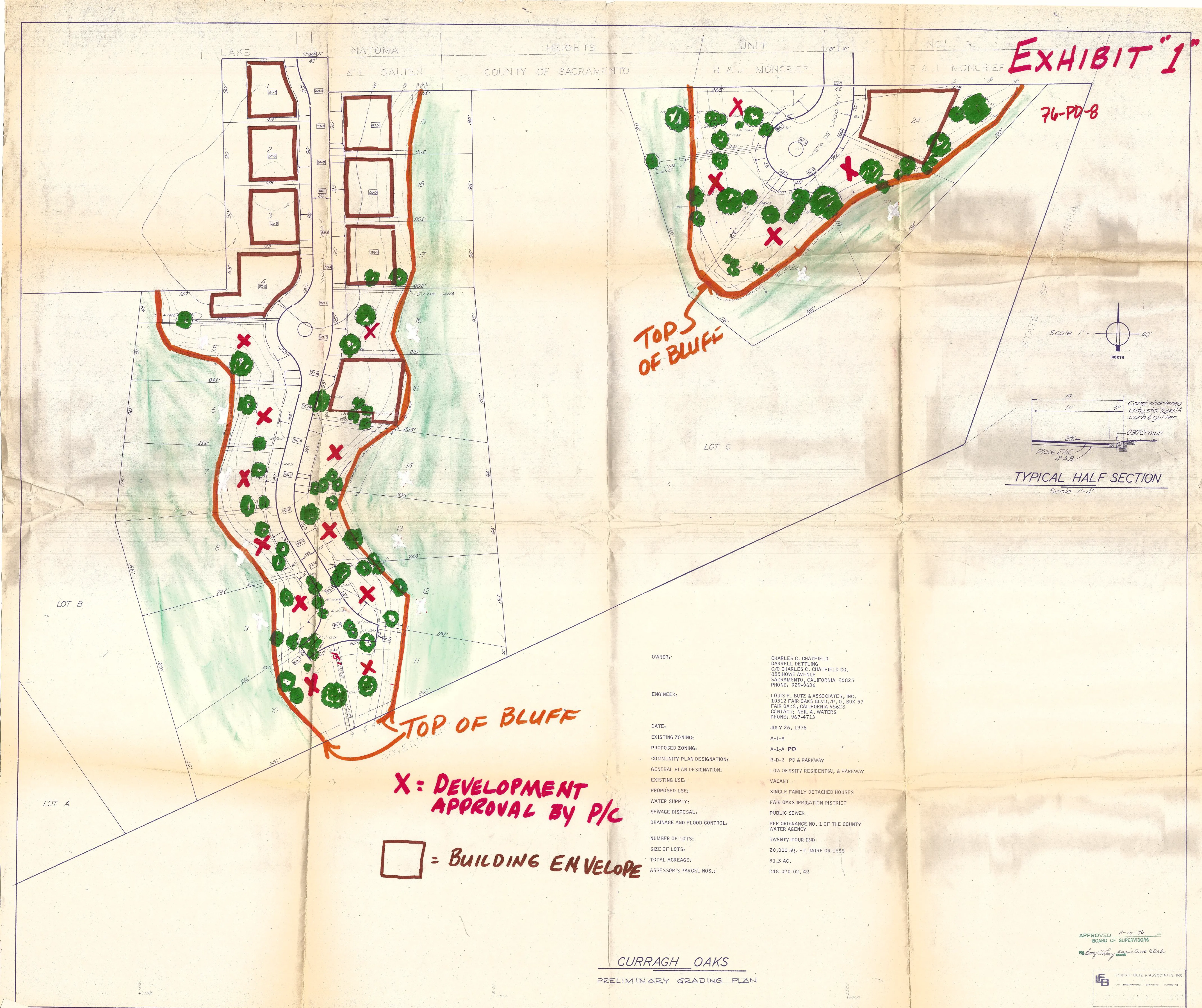
EXHIBIT “2”
Section titled “EXHIBIT “2””