Winding Woods PD
Sacramento County Zoning Code
Winding Woods Planned Development Ordinance
Section titled “Sacramento County Zoning Code Winding Woods Planned Development Ordinance”Adopted June 29, 1977
77-PD-05
SECTION 1. PROPERTY REZONED
Section titled “SECTION 1. PROPERTY REZONED”Section 23.01.185 of the Zoning Code of Sacramento County, Ordinance No. 1111, as amended, which incorporates Comprehensive Zoning Plan Unit No. 356/212, is amended to change the real property described in Exhibit “A” on said Comprehensive Zoning Plan to A-1-A Agricultural (Planned Development) Zone. Exhibit “A” is attached hereto and incorporated herein and made a part of this ordinance.
SECTION 2. INCORPORATION WITHIN ZONING CODE
Section titled “SECTION 2. INCORPORATION WITHIN ZONING CODE”Chapter 1, Article 3, of the Zoning Code of Sacramento County, Ordinance No. 1111, as amended, is hereby amended by adding thereto Section 23.01.362, which shall read as follows:
Section 23.01.362 – Planned Unit Development Ordinance 77-PD-5, commonly known as Winding Woods P.D.
SECTION 3. EXHIBITS INCORPORATED
Section titled “SECTION 3. EXHIBITS INCORPORATED”Exhibits 1 and 2 inclusive, described generally in this section and attached to this ordinance, are incorporated herein and made a part of this ordinance to regulate the property described in Exhibit “A”. The exhibits are on file in the office of the Clerk of the Board of Supervisors and are a part of this ordinance as if fully set forth herein.
EXHIBITS:
- Development Plan
- Grading Plan
SECTION 4. PERMITTED USES
Section titled “SECTION 4. PERMITTED USES”All uses are authorized on the property described in Exhibit “A” which are authorized in the A-1-A Agricultural Zone, with which the Planned Development Zone is combined, including those uses permitted with a use permit, except that: the raising and sheltering of domestic animals, or the establishment of riding stables, boarding stables, or riding academies shall not be permitted, except that dogs, cats, or other household pets may be kept provided they are not kept for any commercial purpose.
SECTION 5. CONFIGURATION OF LOT AND BUILDING
Section titled “SECTION 5. CONFIGURATION OF LOT AND BUILDING”The location, configuration, and arrangement of the lots within the area described in Exhibit “A” shall be as shown on Exhibit “1”.
No building or structure, whether principal or accessory, shall be erected on or moved onto any lot designated on Exhibit “1” with a red “X”; nor shall any building permit be issued for such building or structure until a site plan therefor has been submitted to and approved by the Project Planning Commission. Said site plan shall show:
- The location of existing and proposed structures, and buildings.
- The location and size of existing trees.
- The location of adjacent public rights-of-way and private easements for ingress and egress, if any.
- The location of existing and proposed walls and fences; the height and the construction materials thereof.
- Finished grade of the site at the building.
- An indication of areas intended for landscaping.
- An elevation drawing of all improvements.
- Other data or materials deemed necessary by the Director.
The Planning Commission should limit its review to the following:
- Location of the trees to be removed and to be retained.
- Lot grading.
- Location of improvements on the lot taking into consideration the size and configuration of the lot.
The review provided by this section shall not render said lots undevelopable to the uses and densities established herein. The buildings within the property described in Exhibit “A” shall be located within the lots shown on Exhibit “1”, and in conformity with the height regulations and yard requirements set forth in Sections 23.04.034 and 23.04.035 of the Sacramento County Zoning Code, respectively; provided, however, that the front yards may be reduced to twenty (20) feet on those parcels designated with a red “X” on Exhibit “1”.
SECTION 6. PUBLIC STREETS
Section titled “SECTION 6. PUBLIC STREETS”The location, configuration, and arrangement of the streets shall be as shown on Exhibit “1”. The interior streets of the development shall be offered for dedication as public roads with the rights-of-way shown on Exhibit “1”. Said public streets shall be constructed in conformance with County standards for Class “B” streets as provided in the County Improvement Standards adopted by Resolution No. 73-495 of the Board of Supervisors of the County of Sacramento.
SECTION 7. SUBDIVISION REQUIREMENT
Section titled “SECTION 7. SUBDIVISION REQUIREMENT”Developer and/or the owners shall record a subdivision map of the property described in Exhibit “A”.
SECTION 8. GRADING
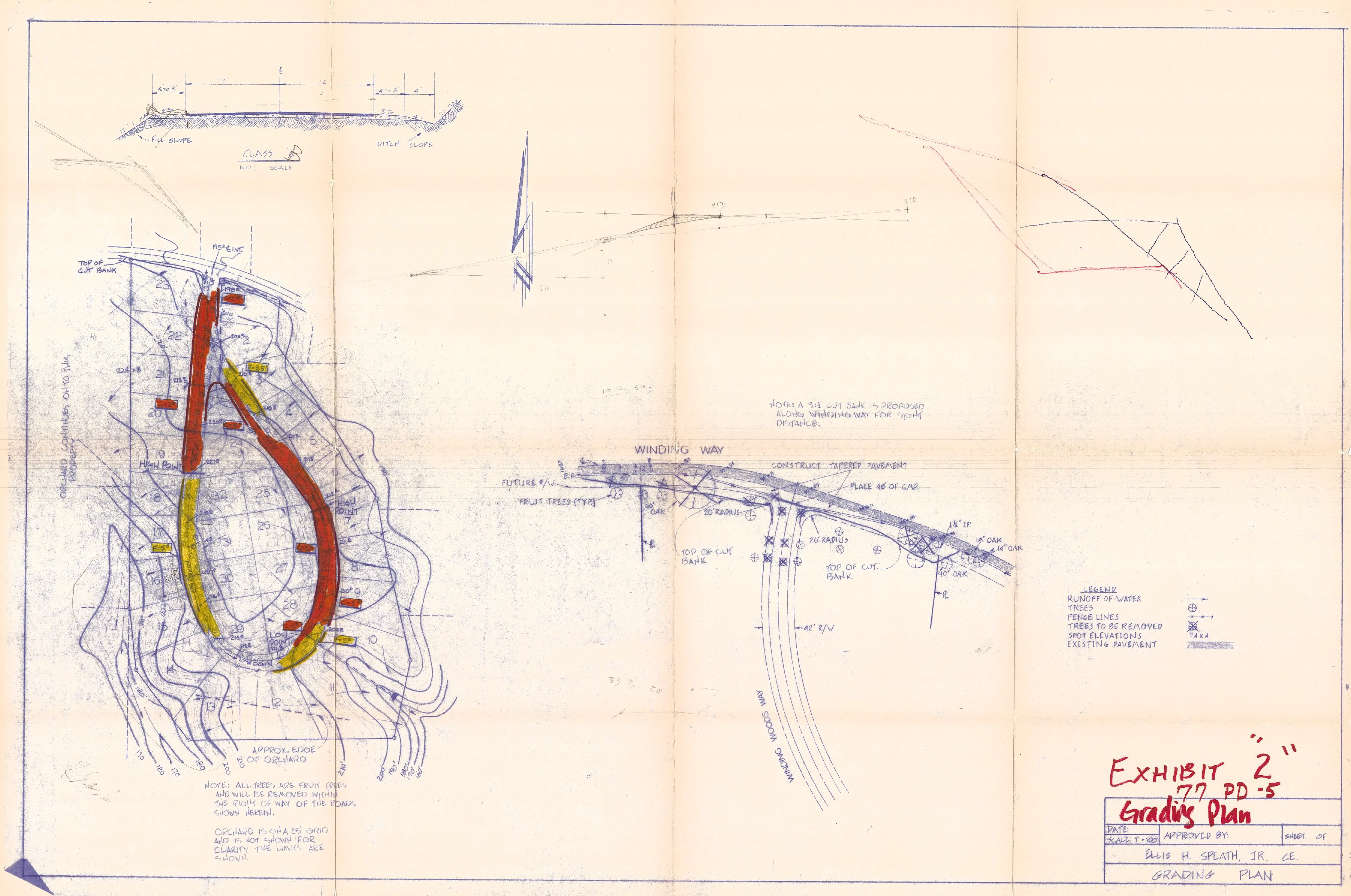
Section titled “SECTION 8. GRADING”Grading on the property described in Exhibit “A” shall conform to the grading plan shown on Exhibit “2”, except that grading necessary for the construction of driveways and buildings shall be permitted on any lot not designated with a red “X” on Exhibit “1”. Grading on those lots designated with a red “X” shall be in conformity with the grading plan approved as part of the site plan review by the Project Planning Commission pursuant to the provisions of Section 5.
SECTION 9. FINDINGS
Section titled “SECTION 9. FINDINGS”During the public hearings on this ordinance the Planning Commission and the Board of Supervisors determined that:
- The proposed development will carry out the intent of the General Plan.
- The proposed development is of sufficient size and is designed so as to provide a desirable environment within its own boundaries.
- The proposed development is compatible with existing and proposed land uses in the surrounding area.
- Exceptions to the standard requirements of the Sacramento County Zoning Code, Ordinance No. 1111, as amended, are justified by the design of the development.
- The arrangements of dwellings and mixing of dwelling types is justified by larger and more usable open spaces.
- There is adequate assurance that all public improvements will be installed at the scheduled times as required by the Public Works Department.
- There is adequate assurance that the development schedule will be met.
- The existing or proposed utility services are adequate for the uses and population densities proposed.
SECTION 10. VARIANCES
Section titled “SECTION 10. VARIANCES”The variance provision of Article 1, Chapter 18, of the Sacramento County Zoning Code, Ordinance No. 1111, as amended, shall not apply to this ordinance.
SECTION 11. VIOLATIONS
Section titled “SECTION 11. VIOLATIONS”Violation of the provisions of this ordinance or exhibits made part of this ordinance shall be deemed a violation of Sacramento County Zoning Code, Ordinance No. 1111, as amended.
EXHIBIT “A”
Section titled “EXHIBIT “A””Beginning at the point of intersection of the centerline of Winding Way and the northerly prolongation of the east line of Lot 2, Block 30, Fair Oaks Tract, the official plat of which is recorded in the Office of the Recorder of Sacramento County in Book 3 of Maps, Map No. 24; running thence S. 00°40’30” E. 935.80 feet, thence S. 06°39’10” E. 165.00 feet, thence S. 37°50’01” E. 236.54 feet, thence N. 88°36’38” E. 545.54 feet, thence N. 12°21’58” E. 188.10 feet; thence N. 14°39’01” W. 137.28 feet; thence N. 13°56’ W. 151.14 feet; thence N. 10°53’ W. 153.78 feet; thence N. 32°08’ W. 219.12 feet; thence N. 35°59’ W. 273.24 feet; thence N. 05°28’ E. 150 feet more or less to centerline of said Winding Way; thence northwesterly along said centerline of Winding Way a distance of 335 feet more or less to the point of beginning, and including the adjacent right of way along Winding Way.
ACTION: To A-1-A(PD)
EXHIBIT “1” TENTATIVE SUBDIVISION MAP AND DEVELOPMENT PLAN
Section titled “EXHIBIT “1” TENTATIVE SUBDIVISION MAP AND DEVELOPMENT PLAN”Note: Lots marked with a Red “X” require P/C approval of development plan.
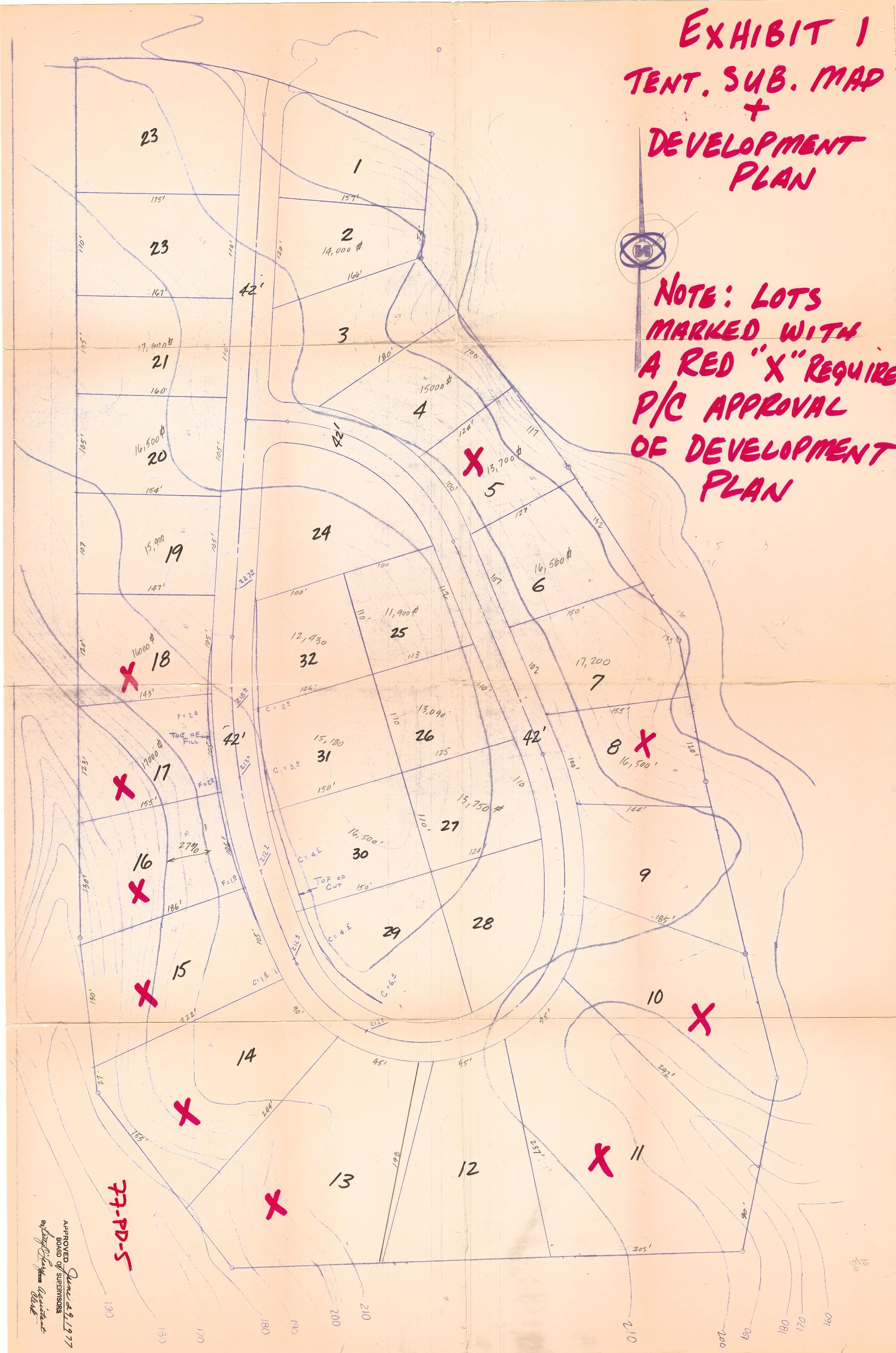
EXHIBIT “2” GRADING PLAN
Section titled “EXHIBIT “2” GRADING PLAN”