Gold River SPA
Sacramento County Zoning Code
Gold River Special Planning Area Ordinance
Section titled “Sacramento County Zoning Code Gold River Special Planning Area Ordinance”Adopted July 12, 1978
78-SPA-12
Adopted by ZMA #3888 (1978 Rancho Cordova Consistency Rezone)
501-120. INTENT.
Section titled “501-120. INTENT.”It is the intent of the Board of Supervisors in adopting this Special Planning Area Ordinance to allow development of the property described in Section 501-127 in a manner which is compatible with the existing physical environment of the site, that provides for improved access to the property in order to minimize traffic congestion on Sunrise Boulevard, and that provides the full range of public services consistent with established levels of service in the community, while providing for a reasonable use of the property.
501-121. PERMITTED USES.
Section titled “501-121. PERMITTED USES.”This special planning area shall include a combination of residential, commercial, business-professional, recreation, open space, institutional, and related uses necessary to create a safe, healthy, and attractive living environment. Notwithstanding the provisions below, those specific uses permitted shall include those described in Sections 201-02 and 225-11 of the Sacramento County Zoning Code for the following land use zones: RD-3, RD-4, RD-5, RD-10, RD-20, SC, and BP.
501-122. GENERAL DEVELOPMENT PLAN.
Section titled “501-122. GENERAL DEVELOPMENT PLAN.”Prior to the submission of any specific development proposals, a general development plan shall be prepared by the property owners and submitted to the Planning Department for review. The plan shall be processed through the Project Planning Commission to the Board of Supervisors for approval. Notice of the hearings before the Planning Commission and the Board shall be as provided in Title I of the Zoning Code. The general development plan shall include, but is not limited to, the following:
- A land use plan indicating the location, acreage, and density of proposed residential land uses and the location and acreage of proposed commercial, institutional, public, recreation, open space, and related land uses, and the areas reserved for future transportation facility options based on recommendations of the General Plan transportation update.
- A circulation plan indicating the location of arterial and collector streets, proposed access points to existing public streets and highways, including Sunrise Boulevard, Hazel Avenue, and Highway 50, proposed transit routes, bicycle routes, or other transportation facilities.
- A drainage plan indicating provisions for on-site disposal of surface water runoff, or information explaining how on-site disposal is hydrologically infeasible.
- A plan for phasing development based on the capacity of the circulation system to accommodate increased traffic generated from uses described in the general development plan.
- Upon approval by the Board of Supervisors, the general development plan shall become Section 501-128 to this Ordinance and shall be a part hereof for all purposes.
501-123. REVIEW BY APPROPRIATE AUTHORITY.
Section titled “501-123. REVIEW BY APPROPRIATE AUTHORITY.”Development may not take place on any property within the area described in Section 501-127, except that it conforms to the approved General Development Plan and the development criteria established in Section 501-124 (below) and is approved by the Planning Director. Any decision of the Planning Director may be appealed to the Zoning Board of Appeals. For purposes of this section, approval of a tentative subdivision shall constitute the necessary approval for that development as required herein. All other development proposals shall require approval by the Planning Director.
501-124. DEVELOPMENT AND PERFORMANCE STANDARDS.
Section titled “501-124. DEVELOPMENT AND PERFORMANCE STANDARDS.”a. Access.
Section titled “a. Access.”- Full development shall be based on the provision of adequate vehicular access. Development shall proceed in conformance with the phasing schedule described in the general development plan and shall be correlated with the provision of access improvements as described therein.
- The applicant shall petition the county and participate in a request to CALTRANS for access to Highway 50 and will participate in the cost of said access in conjunction with county policy. The applicant shall likewise petition the county and participate in the cost of providing vehicular access to Hazel Avenue.
- The cost of all street improvements to Sunrise Boulevard, including signalized intersections, shall be shared by the developer and the county in accordance with policy of the Department of Public Works. There shall be no curb cuts (private access) directly onto Sunrise Boulevard.
b. Services.
Section titled “b. Services.”- The development shall provide a combined surface and groundwater water supply system in conjunction with the City of Folsom's development plans for public water service.
- Prior to the approval of any tentative subdivision map or other specific development proposals, the property owners shall take the necessary actions to initiate annexation to the Folsom Cordova Unified School District.
c. Design.
Section titled “c. Design.”- A sound attenuation device or mitigation measures (setback) shall be provided along Highway 50, along the industrial property boundary to the west and along Sunrise Boulevard to the specification of the County Health Agency.
- A plan for live landscaping along Sunrise Boulevard shall be developed in conjunction with the county and subject to review by the Project Planning Commission.
d. Physical Environment.
Section titled “d. Physical Environment.”- A thorough investigation of the extent and nature of the aquifer recharge function of the site shall be prepared prior to development. Provisions for on-site disposal of surface water runoff shall be included with the general development plan for the site.
- Development plans for lots along the American River shall be subject to approval of the Project Planning Commission and shall include:
- the size, type, color, and location of fencing along the American River Parkway;
- the number, location, and type of the planting along the American River Parkway shall be from the list of native trees and shrubs prepared by the Parks and Recreation Department Native Vegetation Planting Program Advisory Committee;
- all structures shall comply with height restrictions of Section 235-26 (Parkway Corridor Combining Land Use Zone) for the Sacramento County Zoning Code;
- each lot along the Parkway shall be so oriented that the rear yard setback will be along the Parkway boundary, rather than a sideyard setback along the Parkway.
e. Density.
Section titled “e. Density.”- The gross density of residential development in this Special Planning Area shall not exceed 3.5 dwelling units per acre.
501-125. RESERVE AREAS.
Section titled “501-125. RESERVE AREAS.”Areas reserved for future transportation facilities shall be reserved for a period of two years from the date of adoption of this Ordinance. At the end of the two year period, the disposition of reserve areas shall be determined by the Board of Supervisors.
501-126. FINDINGS.
Section titled “501-126. FINDINGS.”- The area which comprises this Special Planning Area includes a portion of the once extensive holdings of the Natomas Company which began gold dredging operations in Sacramento County around 1918. That dredging operation, along with subsequent sand and gravel mining, has created land with special environmental concerns, particularly windrows of dredger tailings, significant wildlife habitat and aquifer recharge potential. In addition, the property currently has severely limited access and borders the American River Parkway for several miles.
- Urban development of this property, although possible, is constrained by the existing environmental features described above. Current zoning alternatives do not provide the flexibility needed to allow urban development of the site in a manner which is sensitive to the site's special features/constraints.
- This special planning area comprises nearly 1,000 acres, one of the largest developable areas in the county. The property is large enough to provide considerable latitude in design to accommodate the special concerns of the area, while allowing a reasonably broad range of development options to the property owners.
- The list of permitted uses and development criteria described herein provide for reasonable use of the land and will not result in undue hardship on property owners within the zone.
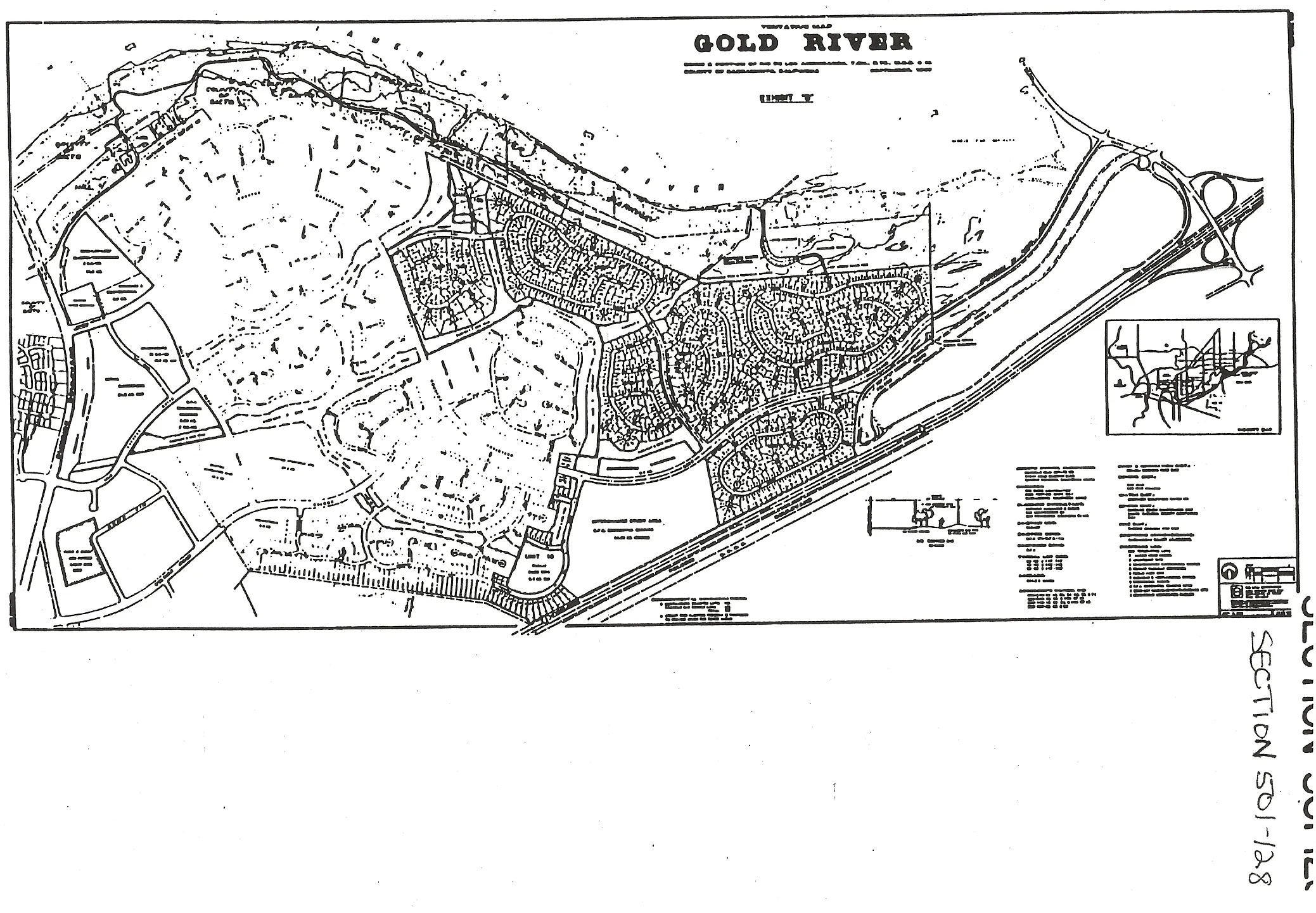
501-127.
Section titled “501-127.”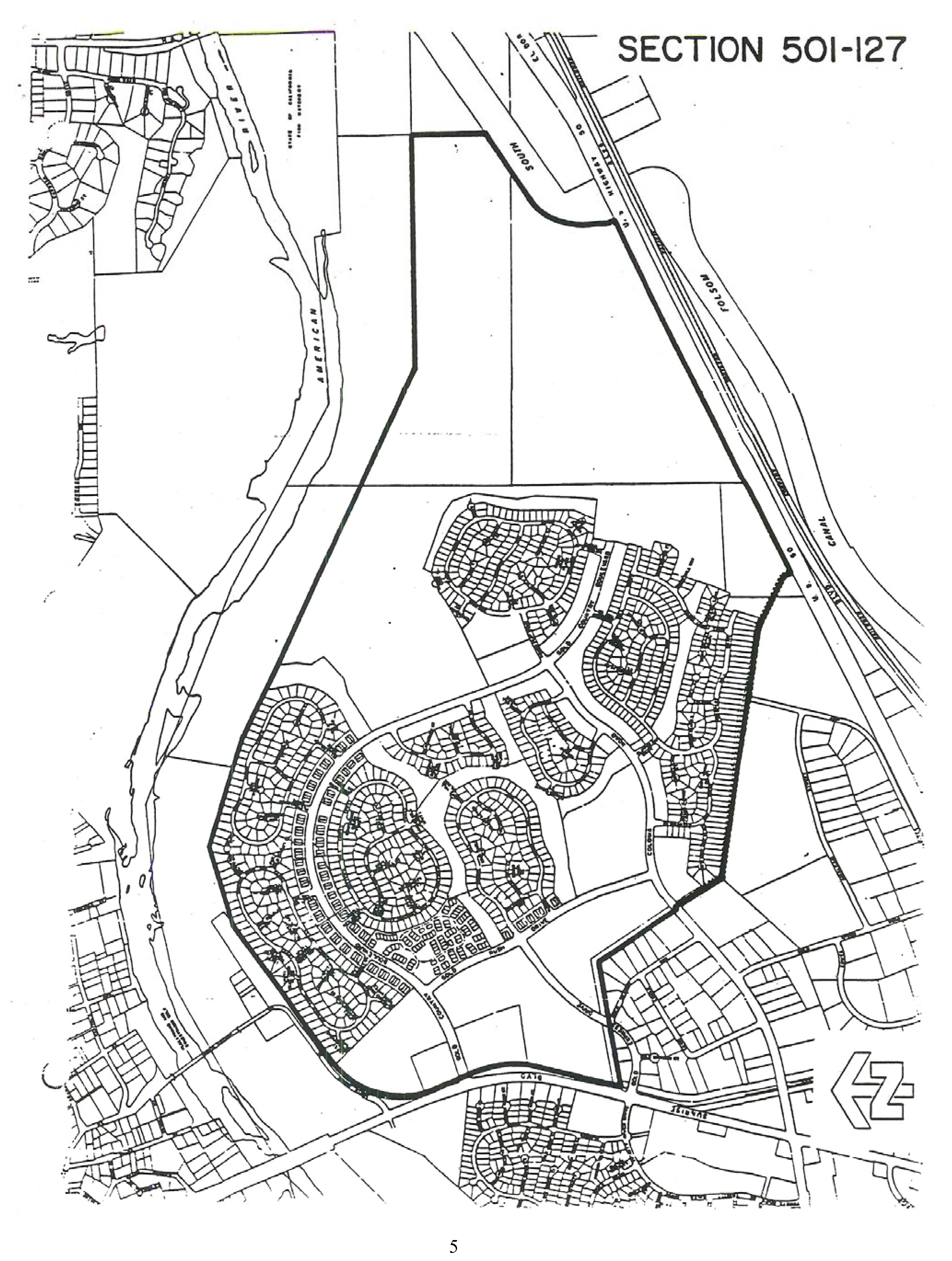
501-128.
Section titled “501-128.”