Larchmont Countryside SPA
Sacramento County Zoning Code
Larchmont Countryside Special Planning Area Ordinance
Section titled “Sacramento County Zoning Code Larchmont Countryside Special Planning Area Ordinance”Adopted July 6, 1988 as the Gibson Ranch SPA
80-SPA-5
503-50. INTENT.
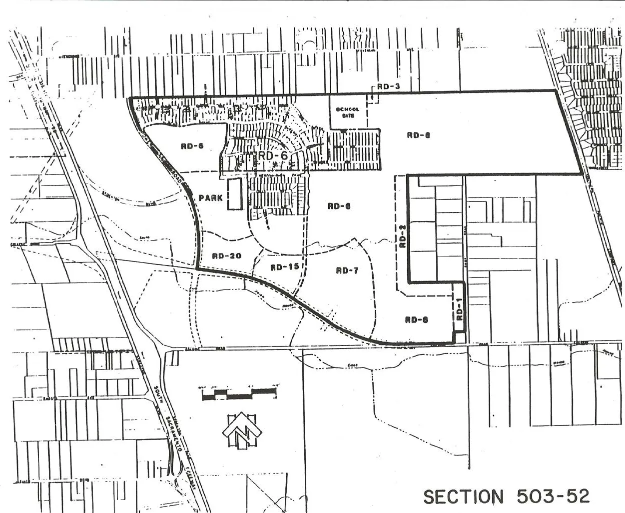
Section titled “503-50. INTENT.”It is the intent of the Board of Supervisors in adopting this Special Planning Area to allow development of the property described in Exhibit 503-52 in a manner which is compatible with the existing physical environment and surrounding land uses, that conforms to current County General Plan Policies and Goals for development within the designated urban area, and that provides the full range of public services, including the future potential use of surface water, consistent with established levels of service in the community, while providing for a rational use of the property.
503-51. APPLICABILITY.
Section titled “503-51. APPLICABILITY.”Special Planning Area 5-3-5 is applicable to development within the boundaries indicated on Exhibit 503-52 attached. Development within the area defined on Exhibit 503-52 must conform to the approved SPA (Special Planning Area) Development Plan as shown on Exhibit 503-52 attached, and the development criteria established in Section 503-55 of this Ordinance and must be approved by the Planning Director, or as otherwise provided herein.
503-52. BOUNDARIES.
Section titled “503-52. BOUNDARIES.”The boundaries of this Special Planning Area are shown on exhibit labeled 503-52.
503-53. PERMITTED USES.
Section titled “503-53. PERMITTED USES.”This Special Planning Area includes a combination of residential, recreational, open space, institutional, and related uses necessary to create a safe, healthy, and attractive living environment.
The following chart indicates the uses permitted and conditionally permitted for each of the land use zones indicated on the SPA Development Plan, identified as Section 503-52, attached.
| ZONES: | PERMITTED USES: |
|---|---|
| RD-1, RD-2, RD-3, RD-4, RD-5, RD-7, RD-10, RD-20, RD-30, O | All those uses designated in the respective zones, Section 201-02 (Residential-Open Space Lots Use Table) of this Code. |
| RD-6 | All those uses designated in the RD-5 zone, Section 201-02, of this Code. |
| RD-12 and RD-15 | All those uses designated in the RD-20 zone, Section 201-02, of this Code. |
503-54. REVIEW BY APPROPRIATE AUTHORITY.
Section titled “503-54. REVIEW BY APPROPRIATE AUTHORITY.”Development may not take place on any property within the area, unless it conforms to the approved SPA Development Plan (Section 503-52) and the development criteria established in Section 503-53 and 503-55 of this Ordinance and is approved by the Planning Director, or as otherwise provided herein. Any decision of the Planning Director may be appealed to the Board of Supervisors. For purposes of this Article, approval of a tentative subdivision shall constitute the necessary approval for that development, as required herein. All other development proposals shall require approval by the Planning Director.
503-55. DEVELOPMENT AND PERFORMANCE STANDARDS.
Section titled “503-55. DEVELOPMENT AND PERFORMANCE STANDARDS.”a. Phasing of Project Development.
Section titled “a. Phasing of Project Development.”Development shall be based on the provision, funding, and phasing of adequate vehicular access and circulation. Development shall conform to the phasing schedule described in this Article and shall be correlated with the access improvements, as described in this Article. The following conditions are to be used as a guide to incremental development of the project. Only the specified dwelling units are to be permitted, based on the listed street improvements and traffic conditions.
- If no major improvements (listed below) are made to the existing street system, development shall be limited to a maximum of 200 units, or discontinued, when the capacity ratio at the Stockton Boulevard/Northbound State Route 99 off-ramp intersection exceeds 1.07, whichever comes first.
- Upon the formation of an assessment district for the purpose of constructing the following described improvements, or the actual construction of the following described improvements, whichever shall occur first, the following described residential and commercial development may occur:
- aa. If extension of Power Inn Road is constructed or financed by way of formation of an assessment district or otherwise as a two-lane facility from Elsie Avenue to Calvine Road, with traffic signals at Elsie Avenue, Route 148, and Stockton Boulevard, up to 1,035 residential units may be constructed. Commercial development may be commenced with this phase of development, providing that adequate street capacity exists, to the satisfaction of the Public Works Department.
- If extension of Power Inn Road is constructed or financed by way of formation of an assessment district or otherwise as a four-lane facility from Gerber Road to Calvine Road, along with a four-lane facility on Elsie Avenue from Stockton Boulevard to Power Inn Road, up to 1,812 residential units may be constructed. Constructing Power Inn Road to a four-lane facility shall include dual northbound left-turn lanes at its intersection with Elsie Avenue. If Elsie Avenue is developed to four lanes, an exclusive eastbound right-turn lane with a long radius corner (50 feet) shall be included at the intersection of Power Inn Road. Improvement of the Mack Road interchange at Highway 99 shall include upgrading of the Southbound to Eastbound loop to eliminate conflicts at Alta Valley Drive and two eastbound lanes at a widened Mack Road overcrossing shall be considered in the ultimate design.
- Full development beyond 1,812 residential units on the project site shall be allowed to proceed as-of-right when a financing mechanism to provide for the construction of the Calvine Road Interchange is established to the satisfaction of the Planning Director and the Director of the Department of Public Works.
- Prior amendments to the Countryside Special Planning Area permitting the withdrawal therefrom of property located to the West by Sanders-O.I. properties, pursuant to Ordinance No. SZC 87-28, and property to the South (by Orchard Properties), pursuant to Ordinance No. SZC 87-40, were previously approved by the Board of Supervisors. Such approvals were based on an understanding and intent to distribute the responsibility for traffic improvements amongst said parties and the remainder of the property, formerly subject of the Countryside SPA, on an equitable and proportionate basis. None of the properties were intended to bear any greater burden, or receive any greater benefit, as separate entities than the property would have had as a part of said Countryside SPA as it existed prior to said properties being withdrawn therefrom. Therefore, no variation of traffic requirements, nor approval of any Ordinance having any effect thereon, shall be approved without notice being given to all owners of property, then, or formerly being located in the Countryside SPA.
At any such hearing, the Board of Supervisors shall give due consideration to the intent hereinabove set forth in this Section.
b. Transportation Improvements.
Section titled “b. Transportation Improvements.”- Developer shall participate in the cost of providing improvements to and in the extension of Power Inn Road and Calvine Road in accordance with County standards and policies in effect at the time of final map recordation.
- The cost of all street improvements to Power Inn Road, including signalized intersections, shall be shared by the developer, other developers benefiting therefrom, and the County in accordance with County policies in affect at the time of final map recordation.
- The developer shall install off-site public street improvements to the satisfaction of the Department of Public Works.
- Direct vehicular access to the major streets, Power Inn Road and Calvine Road, shall be allowed with the approval of the Department of Public Works of Sacramento County.
- All thoroughfares, arterials, and collector streets shall include on-street bike lanes to County standards.
- The developer shall bear the cost of street frontage along the linear park.
- Special planning and design standards are necessary where bike trails intersect with streets and shall be worked out with the Southgate Recreation and Park District and Planning Department.
- Bus turnouts shall be provided along major streets to the satisfaction of the Public Works Department.
- Record an Irrevocable Offer of Dedication (IOD) for the Calvine Road Bypass to a width satisfactory to the Public Works Department.
- Development plans or tentative subdivision maps adjacent to the Calvine Road Bypass right-of-way and located in the Countryside SPA as depicted in Section 503-52 shall include a road design and cross-sections for one-half of the right-of-way. Design shall be coordinated with the Planning and Public Works Department and with Regional Transit.
- Developer shall participate in the Landscape and Lighting Act Assessment District established by the Southgate Recreation and Park District for maintenance of landscaped corridors, parkways and parks.
- The properties within these boundaries are required to participate in any assessment district or other financing mechanism established: (1) to construct a freeway interchange at new Calvine Road (formerly Route 148) and Highway 99; and (2) to construct Power Inn Road as a four-lane facility from Gerber Road to Calvine Road (or any intermediate improvement), including traffic signals at Elsie Avenue, Route 148, Stockton Boulevard, and Auberry Drive.
c. Setbacks.
Section titled “c. Setbacks.”- A residential building setback of 185 feet shall be maintained from the Southern Pacific Railroad right-of-way in accordance with existing County policy.
- A residential building setback of 50 feet shall be maintained from the property line adjoining any land zoned for agricultural-residential uses.
d. Parkways.
Section titled “d. Parkways.”- Design of multifamily areas are to be subject to Planning Department review.
- Design and landscaping of the parks, parkways, and landscape corridors shall be the responsibility of the Southgate Recreation and Park District and approved by the Planning Department of Sacramento County. The design shall include bikeways and appropriately installed landscaping. Fencing within landscape corridors shall be located along the interior boundary of the open space easement, described in this Ordinance, and shall be designed to the satisfaction of the Southgate Recreation and Parks District.
- The developer shall grant to the County an open space easement along the east side of Power Inn Road and the north side of Calvine Bypass Road. The easement shall generally be 20 feet in width, although it may be increased to a maximum of 25 feet at some locations to provide for design flexibility. The easement granted shall meet the requirements of the Open Space Easement Act of 1974 (GC 51070 et seq) and shall specifically provide for public access.
e. Service Financing.
Section titled “e. Service Financing.”The applicant shall execute an agreement with the appropriate agencies regarding participation in the funding or provision of the funding of the following public services:
- Fire Protection. Developer shall provide one-third of the land acquisition cost for the fire station site when requested by the Fire District.
- Parks and recreation
- Off-site street improvements, as defined by this Article
- Performance of any and all provisions of any agreement now existing between developer and Elk Grove School District.
f. Water Supply.
Section titled “f. Water Supply.”The water distribution system shall be designed to utilize a surface water supply when available. The design shall be subject to approval of the Public Works Department. The project is in the franchise area of Citizens Utilities Company of California.
g. Drainage.
Section titled “g. Drainage.”The channel shall be realigned to the satisfaction of the Public Works Department. The design may provide for adequate depth to support fisheries and natural vegetation to enhance its appearance.
h. Landscaping.
Section titled “h. Landscaping.”A plan for appropriate landscaping and provision for its maintenance along specified major existing and proposed streets shall be developed in conjunction with the Southgate Recreation Park District and the County of Sacramento and subject to review by the Project Planning Commission.
i. Density and Development Standards.
Section titled “i. Density and Development Standards.”The development standards applicable to the RD-5 zone shall control development in the RD-6 areas, while the six units to the gross acre maximum shall control density. The development standards applicable to the RD-20 zone shall control development in the RD-15 area and the 15-unit per net acre maximum shall
control density. The development standards and densities for all other areas shall be controlled by the corresponding zones of the Zoning Code.
j. Development Plan Review.
Section titled “j. Development Plan Review.”Multiple-family development shall be subject to review by the Project Planning Commission, pursuant to the provisions of Title I, Chapter 10, Article 7 of the Zoning Code.
503-56. FINDINGS.
Section titled “503-56. FINDINGS.”The Board of Supervisors, in adopting this Article, makes the following findings:
- That the area within the SPA zone as indicated in Section 503-52 has the following significant features:
- The parcel was owned and ranched by the Gibsons, a pioneer Sacramento family.
- A large portion of the site is within the Strawberry and Union House Creek floodplains.
- The area is bordered and impacted by Calvine Road, Power Inn Road and the Southern Pacific rail line.
- The area is bordered by and within the sphere of agricultural uses on Short Road.
- That the said unusual features cannot adequately be buffered and protected by the adoption of any other land use zone.
- That the SPA zone is of sufficient size that the adoption of the regulations contained therein will not constitute the granting of a special privilege, nor deprivation, of property rights.
- That the SPA zone will provide for a reasonable use of the land and not cause undue hardship on property owners within the zone.
- The existing infrastructure is insufficient for urban densities on the site and appropriate measures are necessary to assure adequate circulation and service within the project. Of special concern is access to the area from the Highway 99 freeway.
- The area indicated in Section 503-52 constitutes one of the larger developable areas in the County. The property is large enough to provide considerable latitude in design to accommodate the special concerns of the area, while allowing a reasonably broad range of development options to the property owners.
503-52. MAP OF BOUNDARIES.
Section titled “503-52. MAP OF BOUNDARIES.”