Metro Air Park SPA
Sacramento County Zoning Code
Metro Air Park Special Planning Area Ordinance
Section titled “Sacramento County Zoning Code Metro Air Park Special Planning Area Ordinance”Adopted May 12, 1993 as the Metropolitan Airport/Vicinity Special Planning Area Ordinance
Amended February 25, 1998 & August 5, 1998 & August 5, 2008 & July 8, 2016 & December 1, 2016 & October 16, 2018 & November 19, 2019 & August 23, 2022
83-SPA-3
Adopted by 1989-GPB-ZOB-0781
Amended by 1996-ZOB-SDP-BLS-PAP-ABE-0447 (Metro Air Park) & 1998-ZOB-XXB-0131 & PLNP2007-00447 & PLNP2016-00125 & PLNP2016-00351 & PLNP2018-00075 & PLNP2019-00038 & PLNP2021-00114
505-30. INTENT.
Section titled “505-30. INTENT.”It is the intent of the Board of Supervisors in adopting this Special Planning Area (SPA) Ordinance to allow development of Metro Air Park as a high quality, multi-use, commercial and industrial business park.
Land uses in the Metro Air Park include airport related uses, light manufacturing, high tech research and development, professional offices, retail and recreation. This balanced mix of uses will ensure economic viability while providing an economic business environment, which is complementary to the airport.
Metro Air Park will have a distinctive identity reflecting its relationship to the airport, its orientation around an open space/recreation spine that will also accommodate drainage and wildlife needs and its incorporation of landscape and site design considerations as set forth in the Metro Air Park Landscape and Design Guidelines (Exhibit 100-116).
505-31. EXHIBITS.
Section titled “505-31. EXHIBITS.”Exhibits 100-111, 100-112, 100-114, 100-115, and 100-116 described in this section and adopted by ordinance, are intended to regulate property described by this ordinance. Exhibit 100-116 is on file in the office of the Clerk of the Board of Supervisors, and a part of this ordinance as if fully set forth herein. Exhibits 100-111, 100-112, 100-114 and 100-115 are attached.
- Exhibit 100-111 - Land Use Distribution by Zoning District
- Exhibit 100-112 - Metro Air Park Special Planning Area Boundaries
- Exhibit 100-113 - Deleted
- Exhibit 100-114 - Metro Air Park, Land Use Districts
- Exhibit 100-115 - Metro Air Park, Circulation Plan, as amended 9-23-2022
- Exhibit 100-116 - Metro Air Park, Landscape and Design Guidelines, as amended 9-23-2022
505-32. DEFINITIONS.
Section titled “505-32. DEFINITIONS.”For the purposes of this ordinance, the following definitions are applicable:
-
CLUP Compliance. Any use proposed within the Metro SPA which is not consistent with the terms of the Metropolitan Airport Comprehensive Land Use Plan (Metro CLUP) shall only be permitted upon approval by the Board of Supervisors and after making the necessary findings as required by the Sacramento County General Plan and the Metro CLUP.
-
Floor Area Ratio (FAR). Determined by dividing the gross floor area of all buildings on a lot by the gross area of that lot. Intended primarily to help achieve a lower traffic generation level for the overall business park (i.e., the property described by this ordinance).
-
High Tech/R & D Uses. A building or group of buildings in which are located facilities for scientific research, investigation, testing, for experimentation with limited manufacturing and assembly of products pertaining to the following fields, including similar and like fields:
- Medical, dental or optical
- Medical electronics and equipment
- Computers, parts and chips, integrated circuits
- Automotive design
- Aircraft design
- Physics
- Chemistry
- Biology
-
Lot Coverage. The maximum allowable percentage of a parcel of land covered by a building.
-
Net Acreage. Net Acreage is the total developable area exclusive of major roads, collector and local access streets
505-33. DESIGN REVIEW.
Section titled “505-33. DESIGN REVIEW.”A Design Review shall be conducted to ensure an orderly development pattern, facilitate good design practices and maintain a harmonious character to the design and appearance of property and structures at Metro Air Park. The required Design Review will be bundled with any applicable planning entitlement, as provided for in the Sacramento County Zoning Code.
-
FAA Review. Prior to with Design Review approval, the architect or applicant shall complete and electronically submit the Federal Aviation Administration (FAA) Form 7460-1 to the FAA’s Obstruction Evaluation Group (OEG). Upon FAA review and approval, applicant shall submit a copy of the determination letter stating that the FAA does not object to the proposed plans to the Sacramento County Planning and Environmental Review Division.
-
Applicability. Prior to the issuance of any building permit, all public and private construction, development, redevelopment or improvement projects within the area shown in Exhibit 100-114 shall undergo a Design Review as stated in Section 6.3.2. of the Sacramento County Zoning Code, except:
- Improvements to existing buildings that do not alter the outward appearance of the building exterior;
- Improvements of less than $10,000, excluding signs;
- Public works, utility and maintenance projects, including:
- Roadway and landscape maintenance, repaving, rehabilitation of irrigation, tree trimming, mowing, weed abatement, sidewalk repair, parking lot striping, placement of parking and roadway placards/signs;
- Existing utility improvement and maintenance, undergrounding of utilities, maintenance of utility poles, sewer or water lines, water wells & related facilities, drainage facilities;
- Other public works, utility or maintenance projects as determined by the Director of Planning and Environmental Review.
-
Regulating Documents. The Design Review shall be based on guidelines as described in Exhibit 100-116: Metro Air Park Landscape and Design Guidelines. For uses not addressed in Exhibit 100-116, refer to the Sacramento County Countywide Design Guidelines as the appropriate underlying document.
-
Metro Air Park Property Owners Association (MAPPOA). Concurrent with application submittal to County staff for any Planning application process with Sacramento County, applicants, or their representatives, must submit their proposal to MAPPOA and obtain an written acknowledgement of the project site plan, architecture, and landscape architecture. Written acknowledgement from MAPPOA must be received by the Planning and Environmental Review Division prior to issuance of a Design Review determination.
-
Pre-application Meeting. Applicants, or their representatives, are encouraged to meet with the County staff and review their proposal well in advance of their plans to submit a request for a building permit. A pre-application meeting is not a requirement of the Design Review process; however, receiving “early review and comment” may accelerate the timeframe associated with the formal review of an applicant’s proposal.
-
Application Submittal & Fees. Applicants should refer to the Design Review Program application checklist for submittal requirements and shall submit the package together with the appropriate fees, to the Sacramento County Planning and Environmental Review Division. Within 30 days after receiving the application for Design Review, the Design Review Administrator (DRA), or designee, shall review the application for completeness. If determined not to be complete, the DRA, or designee may request additional information. The application for Design Review will not be deemed complete until all additional information that is required by the DRA has been received. Development of individual sites will require a Design Review determination. Development may not take place on any property within the Metro Air Park SPA until a Design Review determination is obtained from the DRA or as otherwise provided herein. Design Review requests submitted for DRA determination shall demonstrate, by appropriate maps and written explanation, the project’s consistency with Exhibit 100-116 Metro Air Park Landscape and Design Guidelines.
-
Authority & Appeals. The following provisions define the appropriate authority for conducting design review:
- The Design Review Administrator (DRA) is the appropriate authority to conduct Design Review as set forth in the Sacramento County Zoning Code 6.3.2.E.1. The DRA, may make a determination of consistency or inconsistency with the Metro Air Park Landscape and Design Guidelines (Exhibit 100-116).
- Decisions of the DRA may be appealed to the Board of Zoning Appeals pursuant to the provisions of Sacramento County Zoning Code Section 6.1.3.
- Submission Requirements and Review Procedures. Development of individual sites will require a determination of consistency with the Metro Air Park Landscape and Design Guidelines (Exhibit 100-116). Development may not take place on any property within the Metro Air Park SPA until the Design Review determination is obtained from the DRA, or as otherwise provided herein. Design Review requests shall demonstrate, by appropriate maps and written explanation, the project's consistency with Exhibit 100-116 Metro Air Park Landscape and Design Guidelines.
-
Design Review Required Findings. In making the Design Review determination, the DRA must find that the request complies with the intent and follows criteria of this ordinance, and that the design is consistent with the Development Standards of this ordinance.
505-34. SPECIAL DEVELOPMENT PERMITS.
Section titled “505-34. SPECIAL DEVELOPMENT PERMITS.”A proposed project within the Metro Air Park Special Planning Area may request deviations from the Floor Area Ratios (FAR) of Section 505-37 or the Development Standards of Section 505-38 through a Special Development Permit.
-
Purpose. The purpose of a Special Development Permit is to encourage a creative and more efficient approach to the use of land; to maximize the choice in the type of environment available; and to provide a means of greater creativity and flexibility in design than is provided under the strict application of the zoning district development standards while at the same time providing adequate protection of the environment and of the health, safety and comfort of the users of the development.
-
Decision Authority & Appeals.
- The Planning Commission may issue a Special Development Permit to allow deviations from the required Floor Area Ratios or any development standard listed in this document.
- Decisions of the Planning Commission may be appealed to the Board of Supervisors pursuant to the provisions of Sacramento County Zoning Code Section 6.1.3.
-
Effect of Permit. Upon the issuance of the Special Development Permit, the property may be developed either pursuant to the development standards set forth in this document or in the alternative, pursuant to the development standards set forth in the Special Development Permit and the requirements set forth in this document; provided, however, that upon the issuance of any building permit for the construction of streets, utilities, and other facilities pursuant to the development standards set forth in the Special Development Permit, the Special Development Permit shall regulate the property, and shall remain in full force and effect until revoked.
-
General Findings for All Special Development Permits. The hearing body shall not issue the Special Development Permit unless the following general findings can be made:
- That the proposed development will carry out the intent of the SPA;
- That the proposed development is of sufficient size and is designed so as to provide a desirable environment within its own boundaries;
- That the development is compatible with existing and proposed land uses in the surrounding area;
- The proposed development is justified by the project design or by the substantial energy savings proposed;
- That there is adequate assurance that all necessary infrastructure will be installed at the scheduled times;
- That the existing or proposed utility services are adequate for the uses proposed; and
- That the proposed development will not be materially detrimental to the environment or to the health, safety, or general welfare of the people utilizing the development and residents of the County.
-
Issuance of Permit. The Special Development Permit, when approved by the hearing body, shall incorporate the approved plans and detailed regulations setting forth the requirements for development on the site. The permit may, in addition, specify the authority to review and approve details of the development plan, provided that standards for such review are set forth in the Permit. The hearing body may also designate conditions of approval for a Special Development Permit to satisfy the requirements of this document. Such conditions may include, but are not limited to, right-of-way dedication and regulations on building height, landscaping and fencing, and shall be related to the nature of the Special Development Permit.
505-35. PERMITTED AND CONDITIONALLY PERMITTED USES.
Section titled “505-35. PERMITTED AND CONDITIONALLY PERMITTED USES.”Metro Air Park is composed of districts as indicated by Exhibit 100-114 and described below. Uses permitted, conditionally permitted, and prohibited in each district are set forth in Table 1. Additional permitted or conditionally permitted uses are listed in Table 3.1 in Section 3.2.5 of the Sacramento County Zoning Code under the corresponding underlying zoning designation for each district. Temporary and Accessory uses may be authorized as provided for in Sections 3.1.2.C and D of the Sacramento County Zoning Code.
1. District 1: Light Manufacturing and Distribution District
Section titled “1. District 1: Light Manufacturing and Distribution District”Purpose: This district is intended to provide for permitted light industrial uses which include fabrication, manufacturing, assembly, distribution, processing or storage of materials that, for the most part, are already in processed form and which do not in their maintenance, assembly, manufacture, or plant operation create smoke, gas, odor, dust, sound, or other objectionable influences which might be obnoxious to persons conducting business in this or any other zone. The corresponding underlying zone as referenced in the Sacramento County Zoning Code is M-1 (Light Industrial).
2. District 2: Airport Manufacturing and Distribution District
Section titled “2. District 2: Airport Manufacturing and Distribution District”Purpose: This district is intended to provide for most of the uses permitted in Districts 1, plus the permitted light industrial uses which are directly related to airport functions. This includes both those uses which do and do not require physical adjacency to the airport. The corresponding underlying zone as referenced in the Sacramento County Zoning Code is M-1 (Light Industrial).
3. District 3A: Office - Retail/High Tech/R & D District Core
Section titled “3. District 3A: Office - Retail/High Tech/R & D District Core”Purpose: This district is intended to provide for well-designed and controlled high-tech office space and limited commercial services supporting the surrounding uses. The corresponding underlying zone as referenced in the Sacramento County Zoning Code is MP (Industrial/Office Park).
4. District 3B: Office - High Tech/R&D District Periphery
Section titled “4. District 3B: Office - High Tech/R&D District Periphery”Purpose: This district is intended to support the High Tech/R & D District Core by providing the space needed for larger high-tech/research and development uses. Limited manufacturing and assembly of products will be permitted. A mix of industrial, manufacturing, research and office uses is expected to develop. The corresponding underlying zone as referenced in the Sacramento County Zoning Code is M-1 (Light Industrial).
5. District 4: Office/Hotel/Retail Services District - East/West:
Section titled “5. District 4: Office/Hotel/Retail Services District - East/West:”Purpose: This district is intended to provide office space as well as commercial services which are in support of the airport and the Metro Air Park users. The corresponding underlying zone as referenced in the Sacramento County Zoning Code is GC (General Commercial).
6. District 5A: Office/Hotel/Retail Services District - Core
Section titled “6. District 5A: Office/Hotel/Retail Services District - Core”Purpose: This district is intended to serve as the focus of business activity in Metro Air Park by providing for small office uses and retail uses for visitors and employees. It is envisioned as a pedestrian oriented, campus-like environment with direct connections to the surrounding districts, open space system and future light rail transit system. The corresponding underlying zone as referenced in the Sacramento County Zoning Code is GC (General Commercial).
7. District 5B: Office/Hotel/Professional Services District - North
Section titled “7. District 5B: Office/Hotel/Professional Services District - North”Purpose: This district is intended to provide for a variety of general and professional office uses and supplemental services. The corresponding underlying zone as referenced in the Sacramento County Zoning Code is GC (General Commercial).
8. District 5C: Office/Hotel/Retail/Services District - Central
Section titled “8. District 5C: Office/Hotel/Retail/Services District - Central”Purpose: This district is intended to provide office space as well as commercial services which are in support of the airport and the Metro Air Park users. With its visually prominent location at the main gateway off Interstate 5, strong environmental and architectural controls are necessary. The corresponding underlying zone as referenced in the Sacramento County Zoning Code is GC (General Commercial).
9. District 6: Recreation and Open Space District
Section titled “9. District 6: Recreation and Open Space District”Purpose: This district is intended to meet on-site drainage requirements while providing for aesthetic, recreation and land use buffering purposes. The corresponding underlying zone as referenced in the Sacramento County Zoning Code is O (Recreational).
505-36. USE TABLE
Section titled “505-36. USE TABLE”Purpose: The purpose of the Use Table is to designate the permitted, conditionally permitted, and prohibited uses within the buildable area of the districts described above.
Permitted Uses: A “P” in the column opposite a use listed indicates that it is permitted in the district represented by the district number at the top of the column.
Conditionally Permitted Uses: A number in the column opposite a use indicates the use is permitted up to a maximum acreage within the SPA, or permitted with the issuance of a Use Permit and Design Review in the district represented by the district number at the top of the column. The number within the column references the corresponding footnote below the Use Table.
Prohibited Uses: A blank space in the column opposite a use indicates the use is prohibited in the district represented by the district number at the top of the column.
Uses Not Listed: If a use is not listed in the Use Table, refer to the District’s corresponding underlying zone in the Sacramento County Zoning Code to determine whether that use is allowed.
Similar and Like Uses: If a use is not listed in the Use Table or Sacramento County Zoning Code and is similar or like to other permitted uses; the appropriate authority may grant a use permit for such use as provided for in Section 3.2.4.B of the Sacramento County Zoning Code.
TABLE 1: USE TABLE
Section titled “TABLE 1: USE TABLE”| Use Code | Use Classification | Dist 1 | Dist 2 | Dist 3A | Dist 3B | Dist 4 | Dist 5A | Dist 5B | Dist 5C | Dist 6 |
|---|---|---|---|---|---|---|---|---|---|---|
| A. | AIRPORT AND RELATED USES | |||||||||
| A.1 | Aircraft sales, lease, rent, storage, repair charter service | P | ||||||||
| A.2 | Airport-related manufacturing, repair, assembly, sales distribution | P | ||||||||
| A.3 | Hangars, shops and warehousing of merchandise and equipment for aircraft and aircraft ground support equipment | P | ||||||||
| A.4 | Aviation schools | P | P | |||||||
| A.5 | Package delivery/baggage transfer service | P | P | |||||||
| A.6 | Flight kitchens/caterers | P | ||||||||
| A.7 | Offices, when incidental to a permitted use | P | P | |||||||
| A.8 | Food services not occupying more than 15% of the total floor area | P | P | |||||||
| B. | INDUSTRIAL AND MANUFACTURING USES | |||||||||
| B.1 | Machinery shop uses | P | P | P | [5] | [5] | [5] | |||
| B.2 | Sign manufacturing | P | P | P | [5] | |||||
| B.3 | Manufacturing, compounding, processing, assembly, and fabrication | P | P | P | [5] | [5] | [5] | |||
| B.4 | Printing shops, lithography, publish | P | P | P | P | P | P | P | P | |
| B.5 | Assembly of small electrical and electronic equipment | P | P | P | P | [5] | [5] | [5] | ||
| B.6 | Warehousing and wholesale distribution | P | P | P | [5] | [5] | [5] | |||
| B.7 | Moving and storage | P | P | P | P | [5] | [5] | [5] | ||
| B.8 | Mini Storage | P | P | [5] | [5] | [5] | ||||
| B.9 | Offices, when incidental to a permitted use | P | P | P | P | |||||
| B.10 | Food services not occupying more than 15% of the total floor area | P | P | P | P | P | P | P | P | |
| B.11 | Concrete Batch Plant | |||||||||
| B.12 | Animal Slaughter, Tannery, and Rendering | |||||||||
| B.13 | Hazardous Waste Storage/Disposal Facility | |||||||||
| B.14 | Junk Tire Handling | |||||||||
| B.15 | Junkyard, Wrecking Yard, Scrap Yard | |||||||||
| B.16 | Wastewater Disposal | |||||||||
| B.17 | Minor Recycling Facilities | P | P | |||||||
| B.18 | Accessory Use: Storage of Flammable, Explosive or Highly Corrosive Materials | P | P | P | P | |||||
| C. | VEHICLE RELATED USES | |||||||||
| C.1 | Auto rental, wholesale, or lease agency, including limousine service | P | P | P | P | P | P | P | ||
| C.2 | Automobile vehicle storage and service/preparation including wash and preparation facilities | [1] | [1] | [1] | [1] | [1] | ||||
| C.3 | Recreational vehicle and boat sales and rentals | [1] | [1] | [1] | [1] | [1] | ||||
| C.4 | Auto/Truck fueling station with or without convenience store and liquor sales | [1], [6] | [1], [6] | [1], [6] | [1], [6] | [1], [6] | [1], [6] | [1], [6] | [1], [6] | |
| C.5 | Automobile/Truck wash | [1] | [1] | [1] | [1] | [1] | [1] | [1] | [1] | |
| C.6 | Auto commercial parking lot/garage | P | P | P | P | P | P | P | ||
| C.7 | Storage of Towed or Damaged Vehicles and Boats | |||||||||
| D. | RETAIL SALES AND SERVICE USES | |||||||||
| D.1 | Personal services | P | P | P | P | P | P | P | P | |
| D.2 | Restaurants, Eating/Drinking/Lodging: | |||||||||
| D.2.a | Bar/tavern | [2] | [2] | [2] | [2] | |||||
| D.2.b | Brew Pub | [2] | [2] | [2] | [2] | |||||
| D.2.c | Catering service | P | P | P | P | P | P | |||
| D.2.d | Restaurant, Carry-out/Drive-through/Sit-down | [2] | [2] | [2] | [2] | [2] | ||||
| D.2.e | Hotels/Motels | [3] | [3] | [3] | [3] | [3] | ||||
| D.2.f | Hotel with Convention/Conference Facility | [3] | [3] | [3] | [3] | [3] | ||||
| D.2.g | Event Center/Convention Facilities | [2] | [2] | [2] | ||||||
| D.2.h | Restaurant/Coffee Shop/Cafeteria | [2] | [2] | [2] | [2] | [2] | [2] | |||
| D.2.i | Retail use less than 1,500 S.F., auxiliary to hotel use | P | P | P | P | P | ||||
| D.3 | Entertainment/Recreation Services: | |||||||||
| D.3.a | Art gallery/studio | P | P | P | P | |||||
| D.3.b | Public parks and ancillary uses | P | P | P | P | P | P | P | ||
| D.3.c | Museum | P | P | P | P | P | P | |||
| D.3.d | Gyms/Fitness studio | [2] | [2] | [2] | [2] | [2] | [2] | [2] | [2] | |
| D.3.e | Public recreation golf course and ancillary uses including clubhouse, parking | P | ||||||||
| D.3.f | Live/Motion Picture Theater and Performing Arts Center | [2] | [2] | [2] | [2] | |||||
| D.4 | Food, Drug, Liquor Sales: | |||||||||
| D.4.a | Bakery, pastry shop, candy shop | [2] | [2] | [2] | [2] | |||||
| D.4.b | Liquor store/off-sale of alcoholic beverages | [2] | [2] | [2] | [2] | |||||
| D.4.c | Prescription/non-prescription pharmacy | [2] | [2] | [2] | [2] | |||||
| D.4.d | Neighborhood convenience store, food markets | [2] | [2] | [2] | [2] | |||||
| D.5 | General Retail Merchandise Sales | [2] | [2] | [2] | [2] | [2] | ||||
| D.6 | Adult Business Uses | |||||||||
| D.7 | Public Auction, Flea Market | |||||||||
| E. | OFFICE AND PROFESSIONAL USES | |||||||||
| E.1 | General Office | [4] | [4] | [4] | [4] | |||||
| E.2 | Financial offices/Banks | [4] | [4] | [4] | [4] | |||||
| E.3 | Corporate Office | [4] | [4] | [4] | [4] | |||||
| E.4 | Medical or dental office | [4] | [4] | [4] | [4] | |||||
| E.5 | Real estate office | [4] | [4] | [4] | [4] | |||||
| E.6 | Building trades contractors office | [4] | [4] | [4] | [4] | [4] | [4] | |||
| E.7 | Federal and State buildings, facilities, and grounds | P | P | P | P | P | P | P | P | |
| E.8 | Aviation-related offices | [4] | [4] | [4] | [4] | [4] | [4] | [4] | ||
| E.9 | Food services not occupying more than 15% of the total floor area | P | P | P | P | P | P | P | P | |
| F. | HIGH TECH RESEARCH & DEVELOPMENT USES | |||||||||
| F.1 | Research and development facilities | P | P | |||||||
| F.2 | Laboratory, medical, dental, research, or optical | P | P | |||||||
| F.3 | Aircraft related research and development | P | P | P | P | |||||
| F.4 | Offices, when incidental to a permitted use | P | P | P | P | |||||
| F.5 | Food services as one tenant in a building and not occupying more than 15% of the total floor area | P | P | P | P | P | P | P | P | |
| G. | PARKING FACILITIES | |||||||||
| G.1 | Ground-level and/or underground parking facilities. | P | P | P | P | P | P | P | P | |
| H. | RESIDENTIAL USES | |||||||||
| H.1 | All Residential Uses | |||||||||
| H.2 | Recreational Vehicle Park, Travel Trailer Park | |||||||||
| I. | PUBLIC, CIVIC, AND INSTITUTIONAL USES | |||||||||
| I.1 | Cemetery |
Table Footnotes
Section titled “Table Footnotes”-
Permitted use in this district, however, a maximum of 40 acres of these Vehicle-Related Uses are allowed in the Metro Air Park SPA subject to the approval of a design review as required by this ordinance.
-
Permitted use in this district, however, a maximum of 65 acres of these Retail Sales and Service Uses are allowed in the Metro Air Park SPA subject to the approval of a design review as required by this ordinance. An event center or reception hall with capacity exceeding 300 persons (per Fire Department occupancy load calculations) shall be subject to a Conditional Use Permit by the Zoning Administrator. Event centers or reception halls that are accessory to hotels or motels are exempt from the Use Permit requirement.
-
Permitted use in this district; however, a maximum of 40 acres of hotels and motels are allowed in the Metro Air Park SPA subject to the approval of a design review as required by this ordinance.
-
Permitted use in this district, however, a maximum of 420 acres of these office uses are allowed in the Metro Air Park SPA subject to the approval of a design review as required by this ordinance.
-
Permitted use in this district; however, a maximum of 300 net acres of these Industrial and Manufacturing Uses shall be permitted in Districts 4, 5B, and 5C.
-
Permitted with the issuance of a Conditional Use Permit from the Board of Supervisors.
505-37. MAXIMUM FLOOR AREA RATIOS (FAR).
Section titled “505-37. MAXIMUM FLOOR AREA RATIOS (FAR).”The following maximum floor area ratios shall be maintained in the development and the division of any lot within the industrial business park for the primary purpose of realizing no more than 142,535 external daily trips from the overall project, after accounting for TSM measures. Maximum FAR for use categories in the Use Tables of this ordinance are as follows:
-
Manufacturing - .30
-
Distribution - .48
-
High Tech/R & D - .30
-
Airport Related - .30
-
Office - .48
-
Retail Commercial - .26
-
Automotive Related - .26
-
Hotels and Motels - 60 rooms per acre
505-38. DEVELOPMENT STANDARDS.
Section titled “505-38. DEVELOPMENT STANDARDS.”The following sections set forth development standards for each district within the Metro Air Park SPA. Appropriate sections of the Sacramento County Zoning Code are referenced wherever existing regulations apply; otherwise, new standards have been developed for the SPA. In all cases, these new standards exceed the existing minimum standards.
1. Minimum Lot Area.
Section titled “1. Minimum Lot Area.”The minimum lot area shall be 10,000 square feet.
2. Minimum Lot Width.
Section titled “2. Minimum Lot Width.”The minimum permitted lot width shall be 100 feet.
3. Setbacks.
Section titled “3. Setbacks.”The minimum setback from the public street right-of-way shall be 25 feet. The minimum side and rear yard setbacks from the property line shall not be less than 5 feet, and the minimum rear yard shall not be less than 5 feet. The minimum building setback from the snake wall shall be 25 feet. This setback requirement will not apply if Lone Tree Road is located along the snake wall property line.
4. Maximum Building Height:
Section titled “4. Maximum Building Height:”- Districts 1, 2: The maximum permitted building height shall be between 106 and 173 feet above mean sea level, which is the maximum allowed by Federal Aviation Regulations (Part 77). Changes to FAA regulations may reduce this maximum height standard, but any such changes shall not increase the maximum height standards to more than between 106 and 173 feet above mean sea level. Final building height shall be determined prior to the issuance of a building permit.
- Districts 3A, 3B, 4, 5A, 5B, 5C: The maximum permitted building height shall be 173 feet above mean sea level, which is the maximum allowed by Federal Aviation Regulations (Part 77). Changes to FAA regulations may reduce this maximum height standard, but any such changes shall not increase the maximum height standards to more than 173 feet above mean sea level.
5. District-Specific Development Standards:
Section titled “5. District-Specific Development Standards:”a. District 2: Airport Interface.
Section titled “a. District 2: Airport Interface.”No use within this District shall be entitled to directly access Sacramento International Airport property, runways, taxiways or airport facilities, except upon approval of such access by the Department of Airports and Board of Supervisors.
b. District 6: Recreation and Open Space District.
Section titled “b. District 6: Recreation and Open Space District.”The Recreation and Open Space District is intended to:
- Enhance the environmental quality of the developed areas and provide recreational opportunities for the psychological and physical benefit of the employees and visitors;
- Integrate a drainage "channel" from one end of the SPA to the other;
- Accommodate existing endangered, threatened and other wildlife species;
- Buffer different land use areas, and;
- Help lower the overall employee density and trip generation levels while contributing to the overall economic value of the SPA.
The Recreation and Open Space District shall contain a mix of native and ornamental plants, many of which should be suitable to a wetland-type environment. The drainage system shall be developed as a natural-appearing amenity and may be incorporated into a golf course. Open space corridors with walkways shall also be used to separate different land uses and to connect buildings. Landscaped plazas with site furnishings, shade trees, fountains and arcades shall be developed in the Commercial and High Tech/Research and Development cores and link to the larger open space system.
Guidelines for this district are set forth in the Metro Air Park Landscape and Design Guidelines, Exhibit 100-116 of this ordinance.
6. On-Street Parking.
Section titled “6. On-Street Parking.”No on-street parking shall be permitted within Metro Air Park. Parking prohibition signs shall be installed to the satisfaction of the Department of Transportation (DOT). Enforcement of the no-parking provision shall be the responsibility of the County.
7. Bus Turnouts.
Section titled “7. Bus Turnouts.”Bus turnouts shall be provided along major streets to the satisfaction of the DOT and Regional Transit.
8. Street Lighting.
Section titled “8. Street Lighting.”Street lighting shall be provided as required by Sacramento County. Street lighting shall conform to all County improvement standards, and necessary easements shall be granted to accommodate those standards.
9. Metro Air Park Entrances.
Section titled “9. Metro Air Park Entrances.”The primary entrances into the SPA shall require special landscape treatment and a unified theme including similar monument design. A planting island or different street paving material or both shall be installed at these entrances. Entrance designs must be substantially compliant with examples set forth in the Metro Air Park Landscape and Design Guidelines, Exhibit 100-116 of this ordinance.
10. Off-Street Parking Areas.
Section titled “10. Off-Street Parking Areas.”All off-street parking areas shall be in conformance with the provisions for Off-Street Parking, Section 5.9 the Sacramento County Zoning Code, unless otherwise noted below:
- Screening. Parking located adjacent to any collector street may be screened from view by buildings or landscaped berms, or a combination of berms, walls or fences and solid evergreen shrubbery in such a manner as to reduce visibility from any public street.
- Striping. All parking spaces should be clearly outlined on the surface of the parking facility with painted white lines or stone, brick, textured or smooth concrete banding.
- Parking. The Planning Commission may approve a reduction in off-street parking as part of the TSM measures intended to achieve a peak period commute rate of 1.5 persons per vehicle set forth in an adopted TSM Plan as required by this ordinance.
11. Safety.
Section titled “11. Safety.”Access arrangements and fire hydrants shall be provided to the satisfaction of the fire district prior to any combustible construction.
12. Outside Storage and Service Areas.
Section titled “12. Outside Storage and Service Areas.”- No outside storage of materials, merchandise, products, parts or equipment, other than company vehicles, shall be permitted unless screened from view from any public street, in conformance with the Metro Air Park Landscape and Design Guidelines, Exhibit 100-116 of this ordinance.
- All permitted storage structures, exterior trash structures and service areas shall be screened from view from public roadways with a wall, fence, berm, or landscaping.
- No storage areas shall be allowed within any landscape or open space easement or front and rear-yard setback areas.
13. Loading Areas.
Section titled “13. Loading Areas.”All loading activity, including turnaround and maneuvering, shall be made on the site. Loading areas shall be located and/or screened in such a manner as to reduce visibility from any public street.
14. Fencing and Walls
Section titled “14. Fencing and Walls”- All fencing and walls shall be in conformance with Metro Air Park Landscape and Design Guidelines, Exhibit 100-116 of this ordinance. If Exhibit 100-116 is silent, standards of the Sacramento County Zoning Code Section 5.2.5 for the proposed use shall apply.
- Fencing and walls adjacent to streets shall be located outside of any Public Utility Easements (PUE) or Public Utility and Public Facility Easements (PUPFE).
- Fences deviating from standards are permitted with a Special Development Permit from the Planning Commission. Fence standards may be modified by a condition of approval by the appropriate authority as part of a separate entitlement.
15. Site Lighting.
Section titled “15. Site Lighting.”Site lighting shall be in conformance with all applicable standards of the Sacramento County Code Section 5.9.4.G, Metro Air Park Landscape and Design Guidelines Exhibit 100-116 of this ordinance, and the following additional provisions:
- Building and driveway entries, pedestrian walkways, plazas and other activity points shall be illuminated.
- Site lighting shall be coordinated architecturally with buildings and other structural streetscape features and have similar materials and style.
- Pedestrian-scale light standards shall be used adjacent to buildings and within parking areas.
16. Signs.
Section titled “16. Signs.”he Master Sign Program and signage design guidelines are set forth in the Metro Air Park Landscape and Design Guidelines (Exhibit 100-116 of this ordinance). Freestanding signs consistent with the Master Sign Program are subject to Incidental Design Review as set forth in the Sacramento County Design Review Program.
A. Development Standards
Section titled “A. Development Standards”- Freeway Monument Signs. Up to two freeway monument signs will identify Metro Air Park from I-5 near the east and west property boundaries and adjacent to I-5. Freeway Monument signage is subject to the following development standards and administrative process:
- Freeway monument signage shall be substantially compliant with the Freeway Monument Sign example (overall design and development criteria) as described in the Master Sign Program in Section 11.0 of the Metro Air Park Landscape and Design Guidelines and the applicable development standards contained therein.
- The height of the signage wall shall not exceed 70 feet.
- Gateway Signs (Primary Monument Signs). Gateway signs will identify Metro Air Park at its primary entrances or at the freeway interchange. Gateway signage is subject to the following development standards and administrative process:
- Gateway signage shall be consistent with the Primary Monument Sign example (overall design and development criteria) as described in the Master Sign Program in Section 11.0 of the Metro Air Park Landscape and Design Guidelines and the applicable development standards contained therein.
- Secondary Monument Signs. Secondary Monument Signs will identify Metro Air Park at its secondary entrances.
- Secondary Monument signage shall be substantially compliant with the Secondary Monument Sign example (overall design and development criteria) as described in the Master Sign Program in Section 11.0 of the Metro Air Park Landscape and Design Guidelines and the applicable development standards contained herein.
- Tenant Monument Signs. Tenant Monuments Signs will provide street addressing and tenant identification for building at major street driveway entries.
- Tenant Monument Signs shall be substantially compliant with the Tenant Monument Sign examples (overall design and development criteria) as described in the Master Sign Program in Section 11.0 of the Metro Air Park Landscape and Design Guidelines and the applicable development standards contained therein.
- Onsite Directional Signs. On-site directional signage shall be used to provide directional wayfinding information.
- Tenant Wall Signs. Tenant Wall Signs will be attached to the building to be used to identify tenants in both single-tenant and multi-tenant buildings. Tenant Wall signage is subject to the following administrative process:
- Tenant Wall Signs that are substantially compliant with the Tenant Wall Sign applicable examples (overall design and development criteria) as described in the Master Sign Program are exempt from MAPPOA pre-application review and approval and the Sacramento County Design Review program.
- Deviations from the Master Sign Program.
- Minor Deviations. A Minor Deviation from the Master Sign Program consists of: minor color variations and color palette options, minor sign dimension modifications, logo updates and changes, and minor font changes. A Minor Deviation shall be reviewed and approved by MAPPOA and be subject to the Sacramento County Design Review Program.
- Major Deviation. Deviations not deemed to be Minor, as described above, subject to a Special Development Permit, pursuant to the process outline in Section 505-34.
B. Installation Operation and Maintenance.
Section titled “B. Installation Operation and Maintenance.”- Installation, operation and maintenance of primary and secondary monument signs shown in Figure 4 of the Metro Air Park Landscape and Design Guidelines are the responsibility of MAPPOA or their designee.
- When projects and facilities outlined in the MAP PFFP are triggered for any reason (i.e. due to absorption rates or a specific project), any signage associated with those projects or facilities, shall be constructed and installed by MAPPOA or their designee prior to the acceptance and reimbursement of the required facilities.
17. Noise Attenuation.
Section titled “17. Noise Attenuation.”Interior noise levels of structures shall be in conformance with the County Noise Ordinance.
18. Minimum Floor Elevations.
Section titled “18. Minimum Floor Elevations.”Comply with the Sacramento County Water Agency Drainage Ordinance No. 1, as amended.
505-39. LANDSCAPE STANDARDS
Section titled “505-39. LANDSCAPE STANDARDS”Landscape standards of the Sacramento County Zoning Code, Section 5.2.4, for the proposed use, as amended from time to time, shall apply to all new development, buildings, or structures that may be erected or enlarged, and/or the maintenance of existing landscaping for all districts in the SPA, unless a differing provision is listed in this Section. Landscaping shall also follow the applicable Site Development Guidelines of the Metro Air Park Landscape & Design Guidelines, Exhibit 100-116.
1. Landscaping of Setback and Frontage Areas.
Section titled “1. Landscaping of Setback and Frontage Areas.”All areas between the edge of the street right-of-way and the building or parking lot, and visible from the public street, except for driveways and screen areas, shall be landscaped. See Sacramento County Zoning Code Section 5.2.4.F for parking lot landscaping requirements.
A. Frontage Landscaping Adjacent to Parking Lots and Driveways.
Section titled “A. Frontage Landscaping Adjacent to Parking Lots and Driveways.”- A minimum twelve (12) foot wide planter excluding curbing, shall be provided between the edge of parking areas and: 1) sidewalks, where sidewalks are detached from curb and gutter, and 2) street right-of-way where sidewalks are attached. In addition, where the right-of-way is located behind a public sidewalk or curb, any area within the street right-of-way shall be developed as a planter or landscaped area. The planter shall be designed to comply with parking lot shading and street tree requirements.
- Within this planter, trees approved by the Planning Director shall be planted no further than 30 feet on center and at least four (4) feet but not further than 10 feet from the back of the sidewalk. The planter shall also include shrubs, ground covers, and other natural growth, or stormwater quality features and drainage treatments. Nothing in this Section shall preclude the installation of additional landscaping and the planting of additional trees so long as it is consistent with visibility regulations
- Bus shelters may be located within this planter if approved by the Director of the Department of Transportation, or designee, and the regional transit agency, but shall not be placed so as to reduce the number of trees which are otherwise required by this Section.
B. Frontage Landscaping Adjacent to Buildings.
Section titled “B. Frontage Landscaping Adjacent to Buildings.”Within the area between the right-of-way and buildings, trees shall be planted no further than thirty (30) feet on center and at least four (4) feet but not further than ten (10) feet from the back of the sidewalk. The planter shall also include shrubs, ground covers, and other natural growth, or stormwater quality features and drainage treatments. Nothing in this Section shall preclude the installation of additional landscaping and the planting of additional trees so long as it is consistent with visibility regulations.
C. Landscaped Parkways.
Section titled “C. Landscaped Parkways.”When required by the County’s Improvement Standards, a minimum eight (8) foot landscaped parkway shall be provided between the curb (i.e., edge of the street right-of-way) and detached sidewalk.
- Landscape parkways may include earth berms, hedges, fences, or walls in combination with trees and plantings, and may be used for stormwater purposes.
- Alternative landscaping methods and landscape parkway requirements may be considered as part of the Design Review process.
- Street Trees. Approved trees for planting in rights-of-way and public easements shall be subject to the County’s Improvement Standards. Trees not listed in the Improvement Standards, may be planted with the approval of Planning and Environmental Review for tree selections that can provide the greatest benefits (i.e., benefits to shading, health, air quality, water and energy conservation).
D. Clustering and Alternative Design.
Section titled “D. Clustering and Alternative Design.”Alternative design approaches, such as clustering of trees, may also be approved during Design Review.
E. Pedestrian Walks and Connections.
Section titled “E. Pedestrian Walks and Connections.”Required landscape areas should include pedestrian walks and well-marked paths of travel and connections, steps, and similar hard surface areas, provided that such hard surface areas do not cover more than 25 percent of the required landscape areas. A barrier free, four (4) foot wide paved walk may be provided through the required planter at street and driveway intersections to provide unencumbered access for people with disabilities from the sidewalk to the parking lot. Such walk shall be located so as to facilitate the most direct movement of persons using sidewalk curb ramps, if such are provided.
2. Landscape Screening from Public Rights-of-Way.
Section titled “2. Landscape Screening from Public Rights-of-Way.”For industrial uses visible from a public right-of-way, not otherwise screened by required landscaping, a twelve (12) foot wide landscaped area shall be provided adjacent to the right-of-way. Landscaping shall include a combination of trees and shrubs at sufficient intervals to achieve the desired screening. Trees shall be planted at least 30 feet on center. The right-of- way elevation, relative to elevations in the adjoining property, shall be a consideration in selecting landscape plants which can accomplish appropriate visual screening.
3. Parking Lot Landscaping.
Section titled “3. Parking Lot Landscaping.”- No planter shall be less than eight (8) feet wide or have an area less than 40 square feet, excluding curbing. Smaller planter sizes may be considered through the Design Review process.
- Each planter shall include an irrigation system, unless otherwise permitted in Section 5.2.4.B.9 of the Sacramento County Zoning Code.
- Not more than 25 percent of the parking landscaped area may be covered with hard surfaces such as gravel, landscaping rock, concrete, or other impervious materials. Pervious pavement and permeable pavers may be considered a substitute for impermeable hard surface areas as described in Section 5.2.4.B.5.b of the Sacramento County Zoning Code.
- All landscaping shall be within planters bound by a curb at least six (6) inches high. Curbs separating stormwater management landscaping or other landscaped area intended to filter runoff, from parking areas, shall provide curb cuts to allow stormwater run-off to pass through them.
505-40. PERFORMANCE STANDARDS.
Section titled “505-40. PERFORMANCE STANDARDS.”The following performance standards must be met for the property described by this ordinance; the time for compliance is set forth in each standard. If no time for compliance is indicated, then the subject performance standard must be met prior to issuance of any building permit.
Notwithstanding the foregoing, the golf course in District 6 and the Exception Property may be developed prior to implementation of certain performance standards, specifically Performance Standard Nos. 1, 2e, 2f, 2g and any other performance standards deemed inapplicable or deferrable by the County. Refer to the list of conditions of approval for the Metro Air Park Golf Course (Control No. 96-ZOB-SDP-PAP-ABE-0447) for applicable performance standards for the golf course. Refer to the list of conditions of approval for the Exception Property (Control No. 98-ZOB-PAP-XXB-0142) for applicable performance standards for the industrial use.
1. SMUD Facilities.
Section titled “1. SMUD Facilities.”SMUD has identified the need for three future substations to serve the Metro Air Park Special Plan Area (MAP SPA). SMUD has a substation site secured on Meister Way, west of Lone Tree Road. Substation sites shall be dedicated on future tentative maps and final maps to SMUD’s satisfaction. The substation sites will be an approximate size of 250 feet by 250 feet of net useable area (approximately 62,500-square-feet of net usable area) and shall be unencumbered by jurisdictional wetlands, sensitive species, cultural resources, or hazardous wastes or materials. To provide power to the three substation sites within MAP, SMUD will need to secure 69kV easements. The easements widths are 20’ for single circuit 69kV lines and 25’ for double circuit 69kV lines. The MAP landowners shall work with SMUD to secure easements for future 69kV routes in a timely manner to ensure SMUD can construct the facilities ahead of proposed development. The anticipated SMUD 69kV routes will require the following SMUD easement locations:
- Entering Metro Air Park from the southwest corner of Greenbriar Master Plan located in the City of Sacramento and continuing north and west to the Meister Way substation (located on Lot 35).
- Leaving the Meister Way substation and continuing west to Power Line Road. Then north along Power Line Road to Elverta Road and the future Power Line Road substation.
- The south side of Elverta Road from Power Line Road to Lone Tree Road and the eastern boundaries of Metro Air Park.
- Leaving the Meister Way substation heading north to Elkhorn Boulevard and then continuing east along Elkhorn Boulevard to Lone Tree Road.
- Turning north from Elkhorn Boulevard at Lone Tree Road and continuing north along Lone Tree Road to Allbaugh Drive.
- Turning west at Allbaugh Drive to the Lone Tree Road/Allbaugh Drive substation.
- Leaving the Lone Tree Road/Allbaugh Drive substation heading east and then turning north along Lone Tree Road to Elverta Road.
Final 69kV alignments are subject to adjustments based on development needs and SMUD’s approval.
2. Master Drainage Study.
Section titled “2. Master Drainage Study.”The following conditions shall apply to future projects within the Metro Air Park Special Planning Area:
- All proposed development shall be consistent with the latest approved update to the Metro Air Park Master Drainage Study (MDS). The drainage study shall be revised to address issues with non-conforming hydrology used in the modeling and update the overland release analysis. Until such time as the revised MDS is approved, individual projects shall demonstrate to the satisfaction of the Sacramento County Department of Water Resources (Water Resources) that on-site improvements adhere to the onsite detention storage that was assumed in the original modeling, and that the proposed development provides for adequate on-site and off-site overland release.
- Construction of onsite and offsite drainage improvements may be phased, subject to the approval of Water Resources, so long as hydrologic/hydraulic analyses are provided that demonstrate the phased improvements are substantially consistent with the latest approved update to the MDS. Proposed deviations from the latest approved update to the MDS may, to the discretion of Water Resources, necessitate a revision to the MDS. Revisions to the MDS, if required, shall include identification of mitigation measures as needed to demonstrate proposed and existing drainage facilities, including overland release in the roads, will function pursuant to current Improvement Standards and to the satisfaction of Water Resources.
- Proposed tentative maps and/or development projects that deviate from the roadway layout shown on the latest approved update to the MDS, may be required to revise the MDS to the discretion of Water Resources. Roadway layout deviations include, but are not limited to, road realignments and new roads not considered in the MDS.
3. Signage Installation Operation and Maintenance.
Section titled “3. Signage Installation Operation and Maintenance.”- Installation, operation and maintenance of primary and secondary monument signs shown in Figure 4 of the Metro Air Park Landscape and Design Guidelines are the responsibility of MAPPOA or their designee.
- When projects and facilities outlined in the MAP PFFP are triggered for any reason (i.e. due to absorption rates or a specific project), any signage associated with those projects or facilities, shall be constructed and installed by MAPPOA or their designee prior to the acceptance and reimbursement of the required facilities.
- During off-site infrastructure plan review for projects that have frontage which will hold future MAP primary or secondary signs, Planning and Environmental Review will review the off-site infrastructure plans for adequate underground infrastructure (e.g., electrical conduit for future power, irrigation piping for future landscaping, etc.) to support the future MAP primary or secondary sign installation.
4. Public Facilities Financing and Phasing Plan (PFF/PP).
Section titled “4. Public Facilities Financing and Phasing Plan (PFF/PP).”No development shall occur until a comprehensive public facilities financing plan and phasing plan for the area is approved by the Board of Supervisors and the resulting financing mechanism(s) have been implemented. This comprehensive public facilities financing plan shall include major roadways, transit, sanitary sewer, storm drainage, water supply, fire protection, and any other public facilities as determined by the Board of Supervisors. The property owner(s) shall be fully responsible for and advance all costs associated with the preparation of the financing and phasing plan subject to possible reimbursement from the proceeds of the financing mechanism if and when it is formed. This plan shall provide for the requirements in Condition A through H, inclusive (below) and other related improvements required by the Public Works Agency such that all property in the SPA is well served and the SPA area is linked to surrounding major roadways. Development within the MAP SPA shall participate in the financing mechanisms including payment of any development impact fees and participation in Mello-Roos community financing districts formed pursuant to the PFF/PP.
- The following roadway improvements shall be addressed in the PFF/PP and shall be the sole responsibility or fair shared responsibility of the property owners as approved by the Board of Supervisors. All required and proposed roadway improvements shall comply with street section details listed in the accompanying Landscape and Design Guidelines or as modified and approved by County Department of Transportation (DOT). All Right-of-Way dedications will include adjacent 14-foot minimum Public Utilities and Public Facilities Easements (PUPFE) where required. Additional PUPFE may be required when necessary easements for appurtenances are required by utility companies.
- Widen Elkhorn Boulevard to a maximum of 4 lanes from Power Line road to Road B (Bear Paw Drive), widen to a maximum of 4 lanes from Road B (Bear Paw Drive) to Metro Air Parkway, and widen to a maximum of 6 lanes from Metro Air Parkway to Lone Tree Road, including any necessary improvements and signalization at the State Route 99 interchange to accommodate project traffic.
- Power Line Road - Widen to a 2-lane arterial standard from Elverta Road to I-5.
- Metro Air Parkway - Provide 5-lane facility from South Bayou Way to north boundary of the Caltrans right-of-way and a 6-lane facility from the north boundary of the Caltrans right-of-way to New Road (Allbaugh Drive) and a 4-lane facility (96 foot right-of- way) from New Road (Allbaugh Drive) to Elverta Road.
- Lone Tree Road - Construct to 2-lane arterial standard from Meister Way to Elverta Road and from Meister Way to Road F/ Road K if needed.
- New Road (Allbaugh Drive) - Construct to 2-lane arterial standard from Lone Tree Road to Power Line Road.
- Elverta Road - Widen to 4 lanes from Metro Air Parkway to State Route 99 and to a 2-lane arterial standard from Metro Air Parkway to Power Line Road.
- Metro Air Parkway Interchange - Construct partial interchange with I-5 to the satisfaction of Caltrans.
- Widen I-5 to 6 lanes from Metro Air Parkway to State Route 99 to the satisfaction of Caltrans.
- Provide up to 14 new traffic signals as required by Sacramento County Transportation Division including:
- Power Line Road and Elverta Road
- Lone Tree Road and Elverta Road
- Metro Air Parkway and Elverta Road
- Metro Air Parkway and New Road
- Lone Tree Road and New Road
- Power Line Road and Elkhorn Boulevard
- Metro Air Parkway and Elkhorn Boulevard
- Metro Air Parkway and Meister Way
- Lone Tree Road and Meister Way
- Lone Tree Road and Elkhorn Boulevard
- I-5 interchange at Metro Air Parkway (2)
- Metro Air Parkway and South Bayou Way
- Power Line Road and Del Paso Road
- Power Line Road and South Bayou Way
- Airport Boulevard Northbound Ramps and Crossfield Drive
- Revise intersection control at Airport Boulevard and South Bayou Way to provide stop control on the southbound approach only.
- Provide a free right turn on northbound Metro Air Parkway at Elkhorn Boulevard to the satisfaction of the Transportation Division.
- Improve Del Paso Road to 2-lane arterial standards between Power Line Road and the City/County line.
- Improve (south) Bayou Way to 2-lane arterial standards between Power Line Road and the City/County line.
- Improve Power Line Road to 2-lane arterial standards from I-5 to Del Paso Road.
- The PFF/PP shall include the property owners fair share contribution for the following roadway improvements:
- Widen the I-5 southbound ramp approved to Airport Boulevard to provide separate right and left turn lanes.
- Provide a new traffic signal at Airport Boulevard and I-5 Southbound Ramps.
- Transit Facilities. The PFF/PP shall provide a "fair share" contribution to the satisfaction of the Board of Supervisors for provision of public transit/light rail to the SPA site based on improvements identified in the Transit Master Plan adopted by Regional Transit.
- Water and Sewer Service. The PFF/PP shall include provisions for the financing and/or phasing of the following water and sewer requirements:
- Provide public sanitary sewer and water supply facilities in accordance with the Sacramento County Improvement Standards.
- Provide verification from the appropriate water purveyor that an adequate and potable water system is available to service the project.
- A water system designed for fire protection and minimum fire flows shall be provided to the satisfaction of the Natomas Fire Protection District.
- No development may occur until the Sacramento County Water Agency initiates creation of a zone encompassing the project site (SPA) for purposes of collecting development fees or other funding mechanism to the satisfaction of the Sacramento County Water Agency. The purpose of the zone is to provide a means of funding the development, construction and maintenance of a surface water system.
- The public water delivery system which will be constructed shall be designed to be ultimately incorporated into a surface water supply system. This system is to be developed to the satisfaction of the Sacramento County Public Works Agency's Water Resources Division.
- Public sanitary sewer services from the Sacramento Regional County Sanitation District and Sacramento Area Sewer District shall be provided in a manner capable of serving the entire SPA. The necessary trunk and interceptor sewer facilities needed to provide these services are included in the Sacramento Sewerage Expansion Study completed in April 1993 by the Public Works Agency. Funding for the extension of any and all Capital improvements associated with the existing sanitary sewer facilities shall be included as part of the Sacramento Regional County Sanitation District and Sacramento Area Sewer District financing plans.
- Fire Service Facilities. PFF/PP shall include provisions for the following:
- Provide one acre of land for a fire protection facility. The exact facility, location and timing thereof, equipment and operating costs to be provided shall be determined in the PFF/PP to be approved by the Board of Supervisors pursuant to conditions contained herein.
- Drainage Facilities. The PFF/PP shall include provisions for the following drainage facilities and services:
- A benefit assessment district or some other funding mechanism, including annexation to a Storm Water Utility for storm drain maintenance shall be formed to the satisfaction of the County Division of Water Resources once the issue of storm drain maintenance and assessment is resolved between Reclamation District No. 1000 and the Sacramento County Water Agency.
- Detailed engineering studies shall be conducted and completed prior to construction indicating design details and improvements to accommodate drainage from future development. These studies shall be reviewed and approved by the County Division of Water Resources, Reclamation District No. 1000 staff and trustees, and Natomas Central Mutual Water Company.
5. Other Conditions/Requirements.
Section titled “5. Other Conditions/Requirements.”- Each property developer, as part of a tentative map or development plan review application, shall provide a Circulation Plan of streets and sidewalks within the proposed project which is consistent with the general location and number of roadways as shown of Exhibit 100-115, Circulation Plan, and Exhibit 100-116, Metro Air Park Landscape and Design Guidelines.
- Required dedications of right-of-way and roadway improvements shall be made by the property owner or project developer whose property contains or abuts the required improvement. Right-of-way for the indicated streets shall be based on geometries to be approved by the County Transportation Division. Improvements shall be made as part of project development as determined appropriate by the Transportation Division. Public street improvements shall be installed pursuant to the County Improvement Standards and the Metro Air Park Landscape and Design Guidelines. Necessary off-site right-of-way acquisition shall be the responsibility of the property owners.
- Dedicate right-of-way for the extension of light rail service through the SPA. Dedication of land for double track right-of-way, stations and ancillary facilities shall be required. The specific alignment shall be recommended by Regional Transit.
- Each property owner, if subject to light rail Irrevocable Offers of Dedication (IOD) on their property, shall show those IODs as part of a tentative map or design review application and consider the IOD area when designing frontage improvements. Light rail IODs that conflict with required frontage improvements shall be relocated, or a Special Development Permit to the Planning Commission must be requested for reduced frontage improvements.
- Property owners shall participate in any future County-wide funding mechanism to support the operation of transit services in the project area which may be approved by the Board of Supervisors.
- Property owners shall dedicate easements for bus stops and shelter sites at locations within the SPA as approved by the County in consultation with Regional Transit as a condition of tentative map or development plan review approval. As a condition of tentative map or development plan review approval, property owners must a) construct bus shelters, b) provide funding for the construction of bus shelters, or c) enter into an agreement with Regional Transit to provide funding for bus shelters at such time as regularly scheduled bus service is provided to the project.
- Prior to issuance of any building permits for the Property, Project developers within the SPA shall establish or join a Transportation Systems Management (TSM) Association. The Association shall be responsible for preparing and updating a Plan for the SPA as described in Sacramento County Zoning Code Section 5.9.6. Said Plan shall be subject to review and approval by the Planning Commission. The Plan shall promote employee use of alternative commute modes in order to achieve a peak period commute rate of 1.5 persons per vehicle by carpooling, vanpooling, public transit, bicycling, and pedestrian commuting. The Plan shall include:
- The designation of a Transportation Coordinator who shall implement the provisions of the Plan and submit an annual report to the Planning Director.
- A description of pedestrian and bicycle linkages to adjoining uses and transit support facilities.
- Consideration of provisions for telecommute incentives within the office or commercial areas of the SPA.
- Emergency Ride Home Program
- Shuttle Bus Program
- Sponsored Vanpools
- Parking Management Program
- Special Promotions
- The Plan shall include provisions for a regular monitoring program, with specific methodology approved by the Sacramento County Planning Director and the Transportation Division. In the event that the peak period commute rate of 1.5 persons per vehicle is not being met, the Association shall propose additional and/or revised measures to the Plan in a report to the Planning Director, which shall be forwarded to the Project Planning Commission.
- Provide a plan for 24-hour security service within the entire SPA, including the name/phone number of the entity providing such services and location on-site which will serve as a base of operations.
- Consult with the Sacramento County Sheriff’s Department Crime Prevention Unit to ensure the implementation of appropriate crime prevention construction and design.
- Comply with the Metro Air Park Master Air Quality Mitigation Plan (AQMP) for this project.
- Future development within the SPA shall control dust emissions during construction by implementing the following measures:
- Maintain a graveled track at all project entryways to remove mud and dirt from vehicles leaving the site.
- Water all disturbed earth surfaces throughout construction to control dust erosion.
- For any disturbed portions, permanent soil stabilization measures (e.g., paving or landscape planting) shall be implemented immediately following the completion of construction of any portion of the site where construction has occurred.
- All inactive fill stockpiles shall be seeded with native grasses to control dust erosion.
- Prior to construction of any structure containing office and/or commercial uses, the project applicant shall submit to the Sacramento County Department of Environmental Review and Assessment development plans identifying design measures which will reduce interior noise levels for office areas and areas where the public will be received in order to provide an interior noise level of 45 dB (CNEL) or less. Design measures approved for noise attenuation shall be incorporated into the building design.
- Prior to recordation of any final map, grant an avigation easement to the County acknowledging ongoing operations at the Sacramento International Airport, aircraft overflights and associated adverse noise.
- All on-site drainage facilities and grading must meet current Sacramento County improvement standards.
- Prior to the issuance of a grading permit or improvement plan approval, whichever occurs first, the developer shall prepare an erosion control plan as part of the grading or improvement plans, to the satisfaction of the Sacramento County Water Resources Division Chief. The erosion control plan shall be designed to minimize water quality degradation by controlling the runoff of sediment and other pollutants during the course of construction and providing swift stabilization and protection of disturbed areas. Specific measures such as seeding, mulching, coverings, straw bales, detention areas, and other techniques consistent with the erosion control plan goals as approved by the Water Resources Division Chief will be required.
- Submit to Sacramento County Water Resources a storm water quality management plan in accordance with the standards developed for Sacramento County prior to map recordation. Said plan shall provide on- and/or off-site detention in order to provide water quality mitigation for urban runoff.
- Prior to modification, destruction, or alteration of the existing canal system, the SPA property owners shall acquire any necessary permits from the California Department of Fish and Game and U.S. Army Corps of Engineers.
- Development of all or any portion of the SPA property shall comply with all basin-wide, standards, restrictions, or ordinances of the County of Sacramento or the Sacramento County Water Agency from time to time in effect.
- In 2002, the U.S. Fish and Wildlife Service and the California Department of Fish and Game issued Incidental Take Permits to MAPPOA to conduct development activities in the SPA project area when following the guidelines and requirements of the Metro Air Park Habitat Conservation Plan (MAPHCP) and accompanying Implementation Agreement. Sacramento County is also signatory to the agreements. All MAP SPA property owners must be a member of MAPPOA in good standing and comply with all habitat mitigation requirements in advance of converting lands to urban use. Proof of satisfying the mitigation requirements shall be obtained from MAPPOA and/or the Natomas Basin Conservancy and provided to the County prior to the issuance of any development permits.
- Should any cultural resources, such as structural features, unusual amounts of bone or shell, artifacts, human remains, or architectural remains be encountered during any development activities, work shall be suspended and Planning and Environmental Review shall be immediately notified at (916) 874-7914. At that time, Sacramento County Planning and Environmental Review will coordinate any necessary investigation of the site with appropriate specialists as needed. The project proponent shall be required to implement any mitigation deemed necessary for the protection of the cultural resources. In addition, pursuant to Section 5097.98 of the California State Public Resources Code, and Section 7050.5 of the California State Health and Safety Code, in the event of the discovery of human remains, all work is to stop and the Sacramento County Coroner shall be immediately notified. If the remains are determined to be Native American, guidelines of the Native American Heritage Commission shall be adhered to in the treatment and disposition of the remains.
- All storage tanks for hazardous materials shall be designated with leak detection systems and secondary containment.
- Underground storage of hazardous materials shall be limited to Class I flammable materials.
- All air emissions, including, but not limited to, process emissions and tank venting, shall be treated to remove or reduce hazardous air contaminants.
- Systems to remove or reduce hazardous air emissions shall be reviewed and approved by the Sacramento County Air Pollution Control Officer prior to any handling of hazardous materials.
- Prior to handling of hazardous materials, handler shall prepare a contingency plan for spills, fires, or other incidents involving hazardous material incidents. Such contingency plans shall be prepared in cooperation with and reviewed by the Natomas Fire Protection District, the Sacramento County Sheriff, the California Highway Patrol, and the Sacramento County Environmental Management Department.
- Wastewater shall meet all requirements of the Regional Sanitation District.
- Prior to any handling of hazardous materials, users shall prepare a Mass Balance Analysis Program (MBAP), subject to review and approval of the Planning Director in consultation with the County Environmental Management Department. The MBAP shall provide a means of monitoring and accounting for all hazardous materials at all times from arrival on-site through ultimate disposition, including material storage, movement, processing or fabrication, analysis, waste storage, treatment discharge, product storage and shipment off site. Adequate monitoring shall be provided to detect any losses, which shall be immediately reported to appropriate agencies.
- Hazardous wastes stored on-site shall be inventoried and reported to the Natomas Fire Protection District at intervals not to exceed fifteen days.
- A minimum 250-foot setback or buffer area shall be provided along the north and east boundaries of the SPA to increase the distance between target areas subject to pesticide spraying and the developed portions of the project. Acceptable uses of properties within this buffer would be open space, warehouses, storage, parking areas or other low intensity uses that minimize the exposure of people to agricultural chemicals.
- Comply with the Mitigation Monitoring and Reporting Program (MMRP) for this project as follows: The SPA property owners shall comply with the MMRP for various projects within the Metro Air Park SPA, including the payment of 100% of the Department of Environmental Review and Assessment staff costs, and the costs of any technical consultant services incurred during implementation of the MMRP. The estimate of these costs is $8,500.00 for Control No. 96-Z0B-SDP- PAP-0447, $7,500.00 for Control No. 98-Z0BXXB-0131, and $1,750.00 for Control No. 98-Z0B-PAP-XXB-0142. If the initial estimate exceeds the actual monitoring costs, the balance shall be refunded to the property owners, and if the actual monitoring costs exceed the initial estimate, the property owners shall be responsible to pay the additional amount.
- Dedicate visibility easements at each driveway and street intersection location pursuant to the Sacramento County Improvement Standards and to the satisfaction of the Department of Transportation.
6. Annual Reporting:
Section titled “6. Annual Reporting:”- MAPPOA shall provide information to Planning staff on an annual basis pertaining to current property owners within the SPA, acreage owned by each property owner, the current use of each parcel, and development entitlements of each parcel.
- Timing: Receipt by Planning staff must occur on or before July 1st of every calendar year.
- Current Property Owner: Ownership information must be current within 90-days of submittal, subject to verification by the County Assessor’s Office.
- Use of Property: General description based on the Metro Air Park SPA land use descriptions must be included.
- MAPPOA shall provide a TSMP Monitoring Report to County Planning and Environmental Review every July 1st, demonstrating continued compliance with the peak period commute rate of 1.5 persons per vehicle.
505-41. FINDINGS.
Section titled “505-41. FINDINGS.”During the public hearings on this ordinance, the Planning Commission and Board of Supervisors found that:
-
The area included within the SPA is appropriate for a business park development because of its proximity to a proposed light rail corridor, excellent freeway access, and relationship to the Sacramento International Airport. The SPA will provide areas for airport-related land uses in close proximity to the Airport and will not preclude their ability to obtain direct access to the runway system should the need arise. Further, many of the anticipated uses (e.g., offices and corporate headquarters) are expected to generate a significant volume of air travel due to the nature of their businesses.
-
Because of the proximity of the SPA to the Sacramento International Airport, the SPA is an appropriate mechanism to increase Sacramento County’s competitiveness for the location and establishment of airport oriented industries, goods and services in relation to competing markets such as Salt Lake City, Utah; Phoenix, Arizona; and Portland, Oregon which have similar airport business park developments.
-
The SPA may provide advantages to the Sacramento International Airport by supplying convenient retail services, conference facilities and hotel accommodations for air travelers, and a unique economic business environment that may generate a demand for more air traffic routes and diversity in services offered by the Airport which will benefit the region as a whole.
-
The SPA is an appropriate mechanism to provide flexibility and encourage innovation in terms of development guidelines (e.g., multi-user parking areas located behind buildings, textured transitional paving, and an open plaza atmosphere at the core areas which are, in turn, connected to the open space/recreational corridor via short promenades) so as to foster a more pedestrian-friendly environment and fewer vehicle trips within the SPA itself.
-
This SPA is of sufficient size so that the adoption of the regulations contained herein will constitute neither the granting of a special privilege nor deprivation of property rights.
-
The SPA will provide for a reasonable use of the land and not cause undue hardship on the property owners.
-
The application of standard land use zones cannot adequately address the development potential of the SPA.
EXHIBIT 100-111 LAND USE DISTRIBUTION BY ZONING DISTRICT
Section titled “EXHIBIT 100-111 LAND USE DISTRIBUTION BY ZONING DISTRICT”| District # | Zoning District | Gross Acres | Net Acres |
|---|---|---|---|
| 1 | Light Manufacturing & Distribution | 573.1 | 551.4 |
| 2 | Airport Related | 284.6 | 276.7 |
| 3A | Office-High Tech/R&D Core | 15.8 | 14.5 |
| 3B | Office-High Tech/R&D Periphery | 142.5 | 129.3 |
| 4 | Office-Professional Corporate | 118.3 | 108.6 |
| 5A | Office/Hotel/Retail | 10.8 | 9.7 |
| 5B | Office/Retail North | 76.3 | 72.8 |
| 5C | Office/Hotel/Retail Periphery | 238.3 | 217.9 |
| 6 | Recreation and Open Space | 275.2 | 275.2 |
| All | Subtotal | 1,734.9 | 1,656.1 |
EXHIBIT 100-112 METRO AIR PARK SPA BOUNDARIES
Section titled “EXHIBIT 100-112 METRO AIR PARK SPA BOUNDARIES”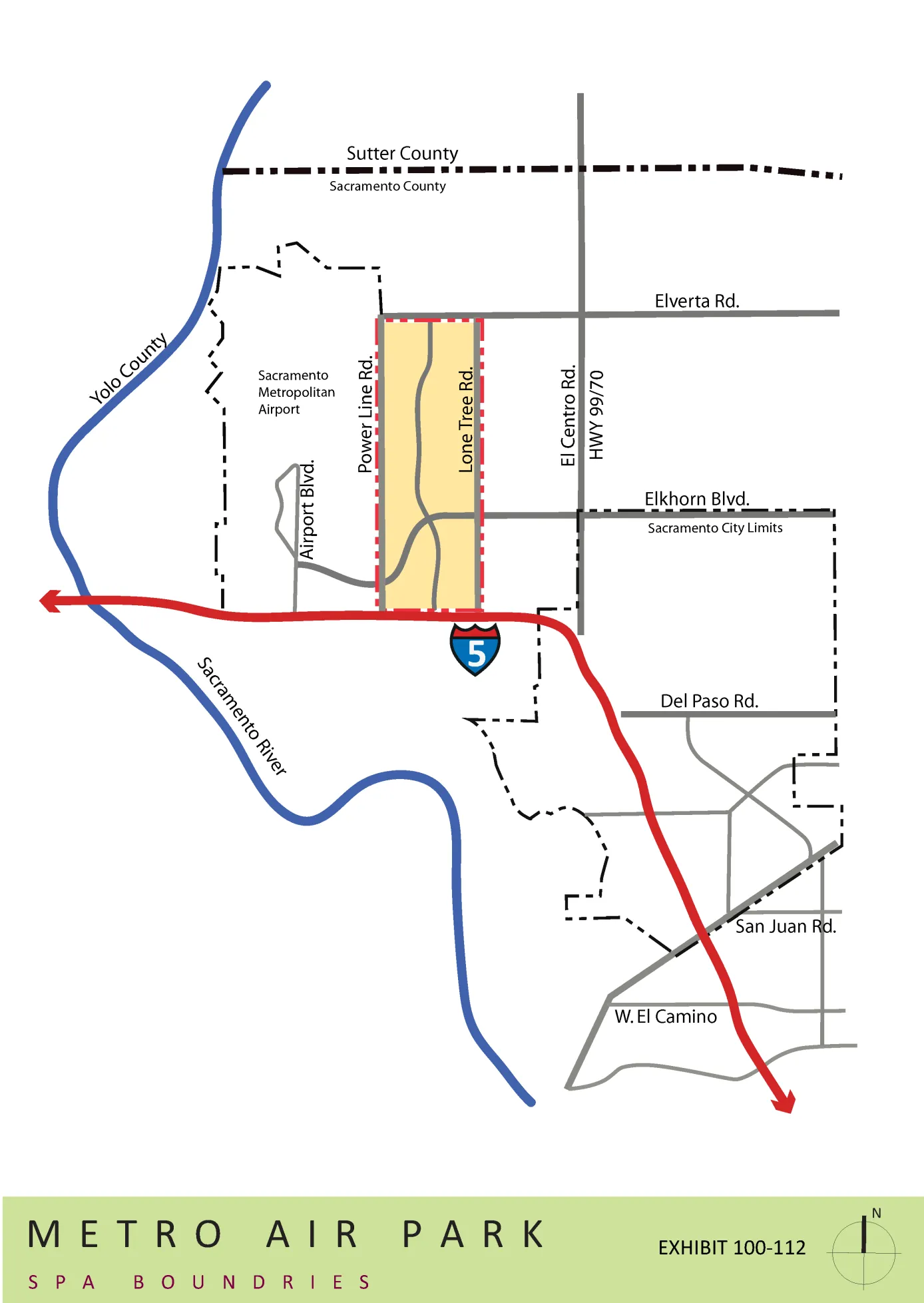
EXHIBIT 110-114 METRO AIR PARK SPA PROPOSED LAND USES
Section titled “EXHIBIT 110-114 METRO AIR PARK SPA PROPOSED LAND USES”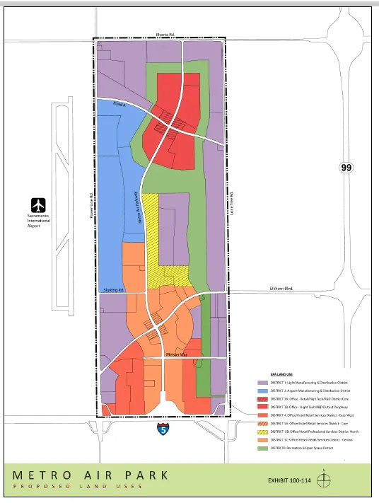
EXHIBIT 100-115 METRO AIR PARK CIRCULATION PLAN
Section titled “EXHIBIT 100-115 METRO AIR PARK CIRCULATION PLAN”[AMENDED 09-23-2022]
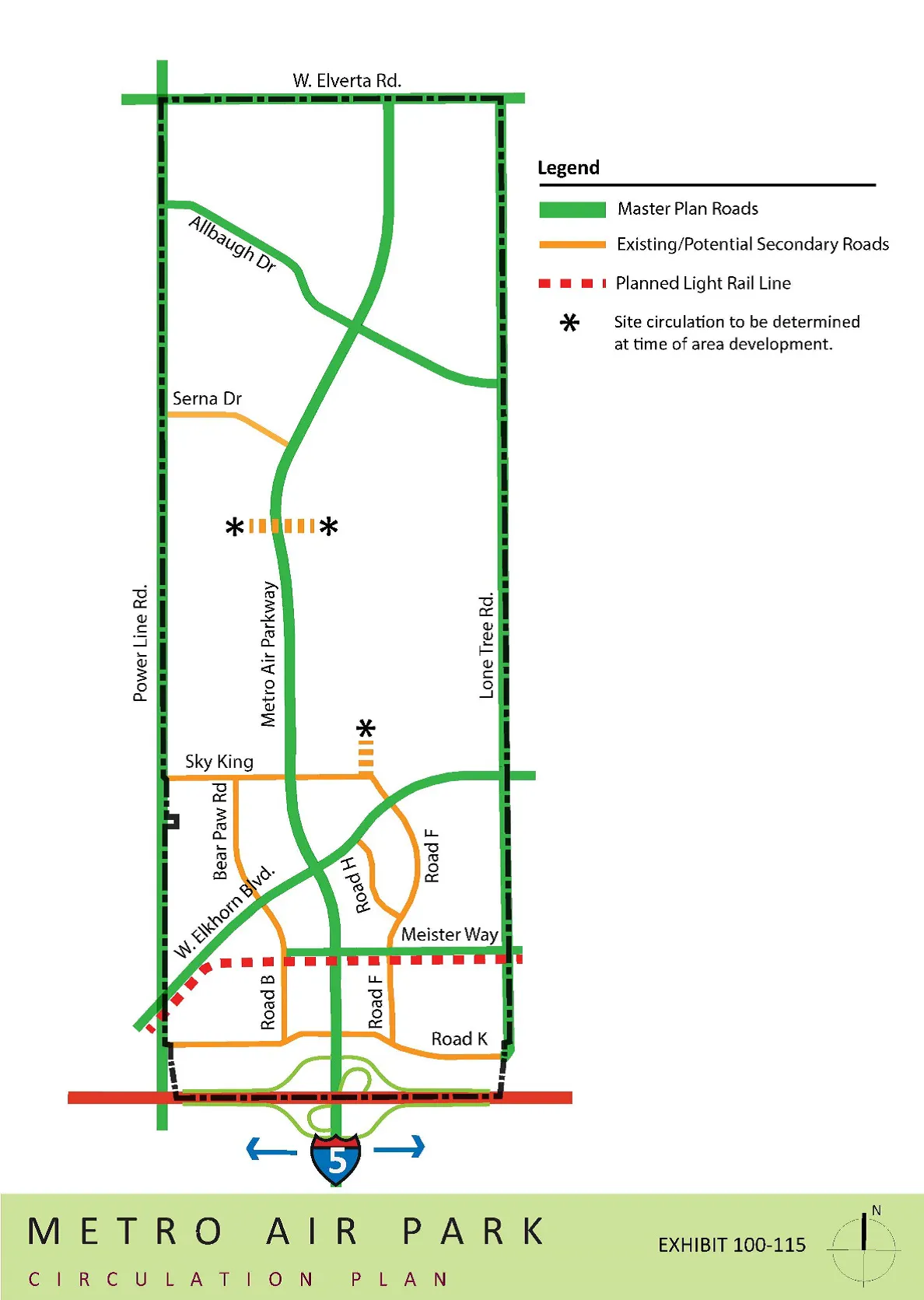
EXHIBIT 100-116 METRO AIR PARK LANDSCAPE & DESIGN GUIDELINES
Section titled “EXHIBIT 100-116 METRO AIR PARK LANDSCAPE & DESIGN GUIDELINES”Download the Metro Air Park Landscape and Design Guidelines
METRO AIR PARK TRANSPORTATION SYSTEMS MANAGEMENT PLAN (TSMP)
Section titled “METRO AIR PARK TRANSPORTATION SYSTEMS MANAGEMENT PLAN (TSMP)”Download the Metro Air Park Transportation Systems Management Plan
METRO AIR PARK MASTER AIR QUALITY MITIGATION PLAN (AQMP)
Section titled “METRO AIR PARK MASTER AIR QUALITY MITIGATION PLAN (AQMP)”Download the Metro Air Park Master Air Quality Mitigation Plan. This is an archived PDF document.