Greenback Lane SPA
Sacramento County Zoning Code
Greenback Lane Special Planning Area Ordinance
Section titled “Sacramento County Zoning Code Greenback Lane Special Planning Area Ordinance”Adopted July 18, 1984
Amended June 3, 1992 & July 23, 1993 & January 10, 1994 & August 20, 2003 & May 25, 2011 & January 12, 2016 & May 11, 2018 & September 19, 2024
Adopted by ZMA #4375
Amended by 1992 Amendment & 1993 Amendment & 1993-ZOB-0212 (261-0220-001) & 2002-ZOB-SDP-SPP-EXR-0594 (The Palms) & ZMA #5625 / & PLNP2016-00483 (8695 Greenback Ln) & PLNP2015-00151 (Downtown Orangevale) & PLNP2020-00042 (6th Cycle Housing Element Rezone Program)
506-20. INTENT.
Section titled “506-20. INTENT.”- Greenback Lane west of Chestnut Avenue: It is the intent of the Board of Supervisors in adopting this Article to recognize the importance of Greenback Lane to the community of Orangevale. In order to promote the development of Greenback Lane in a manner that is more compatible in a spatial and aesthetic sense with the overall rural character of the community, the Board believes it is necessary to establish special design standards for development along this road. One of the major goals of the development plan review process required in this Article is to achieve a visual break in the front elevation of the project such that there is a feeling of looking into a cluster of small structures rather than a solid wall. This will be achieved on an individual basis with consideration given to the scale of the project, amount of frontage, location of buildings on adjoining properties, and two-story versus one-story structures relative to the amount of setback.
In furtherance of this intent, it shall be the policy of the Board of Supervisors, in reviewing projects west of Chestnut Avenue on Greenback Lane in Orangevale, that:- New development west of Chestnut Avenue shall establish a character more consistent with the rural community by incorporating the following special design features:
- Greater and variable setback from Greenback Lane
- Extensive front yard landscaping
- Sensitivity to existing terrain
- Underground utilities
- Minimum sign usage
- Unique street improvements
- 9Shielding of parking areas
- Limited access to Greenback Lane
- Low-scale buildings located in small clusters
- New development shall be adequately buffered from adjacent residential development.
- New development west of Chestnut Avenue shall establish a character more consistent with the rural community by incorporating the following special design features:
- Greenback Lane east of Chestnut Avenue: The intent for this area of Greenback Lane is to define and identify the original and distinct business district in Orangevale by promoting the economic environment, slowing traffic, beautifying and creating an intimate and pedestrian-friendly street scene with gathering places, neon signage, and focal points such as murals, gateways, and theme architecture. The Downtown Orangevale Commercial Design Guidelines (Appendix A) will address the entirety of Downtown Orangevale, which encompasses the area of Greenback Lane east of Chestnut Avenue to the Folsom City limits and Main Avenue north to Orangevale Avenue and south to Madison Avenue, as indicated in the Downtown Orangevale Boundary Map (Exhibit F). However, Downtown Orangevale Commercial Design Guidelines will address only the area of Greenback Lane east of Chestnut Avenue to the Folsom city limits that is covered within the SPA boundaries identified in Section 506-028 (Exhibit D). Areas outside the SPA but within the boundaries of Downtown Orangevale, called 'mutual cooperation zones' in the Commercial Design Guidelines, are encouraged (although not required), at the applicant's option, to follow the Commercial Design Guidelines.
In furtherance of this intent, it shall be the policy of the Board of Supervisors, in reviewing projects east of Chestnut Avenue on Greenback Lane in Orangevale, that:- New development on Greenback Lane east of Chestnut Avenue shall establish a distinct character by incorporating the following guidance in defining Downtown Orangevale as a business district by incorporating the following special design features:
- Reduce landscape setbacks from Greenback Lane
- Underground utilities
- Enhanced pedestrian promenades along Greenback Lane
- Create a special neon/neon-like sign district, permitting neon signs within Downtown Orangevale and utilizing signage in the context of art, as described in the attached Commercial Design Guidelines
- Street improvements, utilizing palm trees and gateways to create district identifiers.
- Low-scale buildings located closer to Greenback Lane along the pedestrian promenade
- Low -scale 'Town and Country'/'California Rancho'/'Mid-Century Modern' themed buildings
- Retaining the underlying zoning, yet restricting certain uses
- New development on Greenback Lane east of Chestnut Avenue shall establish a distinct character by incorporating the following guidance in defining Downtown Orangevale as a business district by incorporating the following special design features:
- All development projects, including land use entitlements and building permits for new construction and renovation proposed within the Greenback Lane SPA, as depicted in Section 506-28, shall be subject to the County's Development Plan Review and/or Design Review procedures, as addressed in Section 506-24.
- Existing structures inconsistent with the above suggested features should not expand unless the expansion is in conformance with this Article.
506-21. ZONING CODE PROVISIONS.
Section titled “506-21. ZONING CODE PROVISIONS.”Unless otherwise specified in this Article, provisions of Chapters 1 through 7 of the Sacramento County Zoning Code (SZC) shall apply.
506-22. EXCEPTION FOR EXISTING SINGLE-FAMILY RESIDENCES.
Section titled “506-22. EXCEPTION FOR EXISTING SINGLE-FAMILY RESIDENCES.”Single-family residences, located within residential zones, existing as of July 18, 1984, may expand or rebuild to the standards of the residential land use designation, as specified on Exhibit 1 in Section 506-28.
506-23. PERMITTED USES.
Section titled “506-23. PERMITTED USES.”- For the area east of Chestnut Avenue and west of Folsom City Limits on Greenback Lane, those uses permitted under the land use zoning designation in the SZC, as specified in Section 506-28, shall apply, except for the following prohibited uses:
- Card Room
- Drug or Paraphernalia Sales
- Massage Parlors
- Pawn Shops
- Storage Facilities
- Liquor Stores
- Tattoo Parlor
However, any of these uses that are currently operating under a legal business license on this stretch of Greenback Lane, can continue business operations and, can expand or move to another location in Downtown Orangevale providing that the Planning Director determines that there will be no additional nuisance impacts to adjacent businesses or residences resulting from the expansion or relocation. These existing businesses would not be considered non-conforming uses. - For the area west of Chestnut Avenue on Greenback Lane, those uses permitted under the land use zoning designation in the SZC, as specified in Section 506-28, shall apply:
- Single-Family Homes on Residentially Zoned Parcels. With the exception of those parcels listed in Section 506-24(b), one single-family home may be built to the standards of the residential land use designation, as specified on Exhibit "1" in Section 506-28, on any residentially zoned parcel existing as of July 18, 1984, without a Development Plan Review. For those parcels listed in Section 506-24(b), single-family homes are prohibited unless developed to the minimum density requirement applicable to the underlying zone for the parcel pursuant to Section 5.4.3.B. Table 5.8.A. of the SZC.
- Cluster Developments. Cluster developments may be permitted by a use permit heard by the Project Planning Commission, in all agricultural-residential land use designations and residential land use designations. Densities through the RD-7 designations may be increased as set forth in Section 506-25(a) of this Article. For those parcels listed in Section 506-24(b), the developments shall use the minimum and maximum density applicable to the underlying zone for the parcel pursuant to Section 5.4.3.B. Table 5.8.A. of the Sacramento County Zoning Code.
- Assessor's Parcel No. 261-0210-020, located at the northwest corner of Greenback Lane and Hickory Avenue, is designated as LC and all uses as permitted or conditionally permitted in the SZC shall be allowed with the exception of the prohibited uses outlined in Section 506-30 (1). (Added 5/2018).
- Assessor's Parcel No. 261-0210-005, located at 8685 Greenback Lane, on the north side of Greenback Lane, approximately 190 feet west of Hickory Avenue, shall not have the following uses as outlined in Section 506-29 (1). (Added 5/2011)
506-24. DEVELOPMENT PLAN AND DESIGN REVIEW.
Section titled “506-24. DEVELOPMENT PLAN AND DESIGN REVIEW.”Those projects within the boundaries of Downtown Orangevale, within the Greenback Lane SPA, shall conform to the attached Commercial Design Guidelines and shall be subject to the County’s Design Review program. Projects within Downtown Orangevale (Exhibit F), outside the SPA, are encouraged to follow the Commercial Design Guidelines, subject to applicable review procedures for Development Plan Review, addressed in Section 6.3.1 of the SZC and/or the County’s Design Review program. Otherwise, all uses permitted under the land use designation in the SCZC, as specified in Section 506-28, except as otherwise provided for herein, shall be subject to Development Plan Review and/or the County’s Design Review program, as applicable.
- Multifamily residential projects specified in Section 506-25(a) shall only be subject to the County's Design Review program and Affordable Housing Incentive Program (Section 6.5.4. of the SZC), unless accompanied by a discretionary entitlement, in which the project will be subject to the applicable entitlement review process.
- The parcels rezoned by the County to satisfy the 2021-2029 Housing Element Cycle Regional Housing Needs Assessment (RHNA) for lower-income households are listed below:
- APN 261-0210-019
- APN 261-0220-038
506-25. DEVELOPMENT STANDARDS.
Section titled “506-25. DEVELOPMENT STANDARDS.”Those projects within the boundaries of Downtown Orangevale shall conform to the attached Commercial Design Guidelines (Appendix A), as applicable. For the area on Greenback Lane, west of Chestnut Avenue, unless otherwise specified in this Article, development standards shall be as required by the SZC for the type of use indicated in Section 506-28.
Multifamily residential projects that provide at least 20 percent of proposed housing units as affordable to lower-income households located on parcels rezoned by the County to satisfy the Regional Housing Needs Assessment (RHNA), as listed in Section 506-24(b), shall utilize the density and development standards in Section 5.4.5. of the Zoning Code for the underlying zoning district applicable to the parcel, and the objective Design Standards listed in Section 3.0 of the Countywide Design Guidelines.
b. Densities.
Section titled “b. Densities.”Densities for cluster developments may be increased to a maximum average of ten (10) units per acre. The maximum density shall not exceed five (5) units per acre within 100 feet of any agricultural/residential zone or residential zone (RD-1 through RD-7) located to the rear of the property. This area may be used when computing the average density of ten (10) units per acre for the project.
c. Development on Existing Small Parcels.
Section titled “c. Development on Existing Small Parcels.”Small parcels existing as of July 18, 1984, may be developed without Development Plan Review to the standards of the zone shown on Exhibit “A” through “C” in Section 506-28 and are not subject to the standards in this Article when the existing parcel is 150 feet, or less, in depth, measured from the future Greenback Lane right-of-way and/or 10,000 square feet, or less, in net lot area.
d. Front Yard Setbacks on Greenback Lane for all Uses.
Section titled “d. Front Yard Setbacks on Greenback Lane for all Uses.”- All buildings and structures, including carports, and accessory structures and parking areas shall be set back 50 feet from the ultimate right-of-way along Greenback Lane.
- Setback Reductions. In order to accomplish a better site design and to provide greater flexibility in building design and solar orientation, the 50 foot setback requirement may be reduced as follows:
- Any part of a structure and/or a parking area may encroach to a setback of 30 feet if the landscaped area in front of the structures and/or the parking area average a setback of 50 feet for the project. No portion of a structure or a parking area with a setback greater than 75 feet may be considered in obtaining an overall average.
- When structures within 100 feet of Greenback Lane do not exceed 24 feet in height and one story, the setbacks may be reduced to an average of 30 feet with a minimum of 20 feet when all of the following criteria are met:
- The parking areas are located to the rear of the structures, or at least 50 feet from the ultimate right-of-way.
- Landscaped berms averaging three (3) feet in height are provided.
- No structures with a setback greater than 50 feet may be considered in obtaining an overall average setback. (See standards which are illustrated on the following page.)
e. Landscaping.
Section titled “e. Landscaping.”- Front Yards. The required front yard setback area, except for sidewalks, outdoor dining and seating within the building setback area, and driveways, shall be landscaped from the edge of pavement to the building and/or parking area with live turf, groundcover, shrubs, mounds, and trees such that autos within parking areas are screened from view within five (5) years of planting, and a rural character is maintained.
- Shading. The front yard landscape area shall include shade trees from the County Tree List and be placed so as to cover 50 percent of the total front yard area with a canopy within 15 years of planting.
f. Street Improvements, Sidewalks, and Access within the boundaries of Downtown Orangevale shall be consistent with the attached Streetscape Master Plan (Appendix B), otherwise.
Section titled “f. Street Improvements, Sidewalks, and Access within the boundaries of Downtown Orangevale shall be consistent with the attached Streetscape Master Plan (Appendix B), otherwise.”-
Street Improvements. Subject to approval of the design by the Department of Public Works, the street section shall be as illustrated on Exhibit “E” and be comprised of: standard pavement width, a concrete header at the edge of pavement, a landscaped swale for drainage purposes, and a meandering sidewalk to the standards set forth below in Section (2). The use of a concrete header and drainage swale in lieu of a concrete curb and gutter shall be required where practical, based on existing development and topography.
-
Sidewalks. Sidewalks, except at street intersections, existing sidewalks, and bus turnouts, shall meander from a minimum of nine (9) feet, to a maximum of 20 feet, from the edge of the pavement.
-
Driveway Access. Access to Greenback Lane shall be limited to the extent possible by cross-easements and reciprocal parking agreements, to be considered on a project-by-project basis.
g. Space between Buildings Fronting on Greenback Lane.
Section titled “g. Space between Buildings Fronting on Greenback Lane.”Space between buildings, commercial and residential in a cluster development, shall be as set forth in Section 5.4.3, Table 5.8, of the SZC. However, as an element of the plan review, the appropriate authority may vary the requirements up to 50 percent in order to meet the intent of this Article.
(h) Height for all Structures and Buildings.
Section titled “(h) Height for all Structures and Buildings.”- Height shall not exceed two (2) habitable stories or 40 feet, except as otherwise set forth in Section 5.5.2, Table 5.13, Commercial Zoning Districts, of the SZC.
- Height shall not exceed 24 feet and shall not exceed one story when located within 100 feet of any property zoned RD-1 through RD-7, or AR-1 and AR-2.
- Height shall not exceed 24 feet and shall not exceed one story when located within 100 feet of the future right-of-way of Greenback Lane when the average setback is less than 50 feet, as provided for in Section 506-25(d)(2).
(i) Signs.
Section titled “(i) Signs.”- On-site signs are permitted as regulated by Section 5.10 of the SZC, based upon the zoning classifications prescribed by Sections 506-23 and 506-28, except that neon/neon like signs may be permitted in Downtown Orangevale, consistent with the Intent of the attached Commercial Design Guidelines.
- Off-site signs are specifically prohibited, except directory signs.
(l) Signs, Vacant and Redeveloped Properties.
Section titled “(l) Signs, Vacant and Redeveloped Properties.”Notwithstanding the provisions of Subsection (i), above, on-site signs on those properties specifically designated on Exhibits “A”, “B”, and “C” shall be regulated by Section 5.20.7, Special Sign Corridors, of the SZC.
In addition, on-site signs on any other parcel shown on Exhibits “A”, “B”, and “C” shall conform to the Special Sign Corridor standards when any of the following occur:
-
Any existing buildings or structures on the parcel are enlarged or expanded to the extent that the total building area after such enlargement exceeds the building area prior to enlargement by 50 percent or more, or
-
Any new buildings or structures are constructed on the parcel and the resulting building area on the parcel exceeds the existing building area by 50 percent or more, or
-
The existing buildings or structures on the parcel are destroyed, demolished, or removed from the parcel and are replaced with new buildings or structures.
(j) Underground Utilities.
Section titled “(j) Underground Utilities.”Unless it is determined by the Planning Director to be impractical due to existing development or natural features, utilities shall be underground for all projects. The Planning Director may request a recommendation from the appropriate utility company.
(k) Buffer Walls.
Section titled “(k) Buffer Walls.”- The use of buffer walls should be avoided by innovative methods of project design utilizing greater setbacks, mounding, single-story structures with solid walls facing the arterial and use of office buildings fronting on the arterial. If there is no other alternative, such as the cluster development approach or frontage roads, the following standards for buffer walls shall apply:
- Buffer walls shall have an average setback of 20 feet from the ultimate right-of-way and may vary in setback to a minimum of ten (10) feet. Mounds shall be used with walls that are required to obtain a height of more than five (5) feet above the grade of Greenback Lane.
- Landscaping. All setback areas shall be landscaped with groundcover, shrubs, vines, and mounds such that at least 50 percent of the buffer wall shall be screened from Greenback Lane within five years. Trees shall be placed so as to cover 50 percent of the total landscaped area with a canopy within 15 years of planting. Buffer walls may not be used unless an automatic sprinkler system is installed and a maintenance program is established to provide ongoing maintenance of the wall and landscaped area.
506-26. SPECIAL DEVELOPMENT PERMITS.
Section titled “506-26. SPECIAL DEVELOPMENT PERMITS.”Those projects within the boundaries of Downtown Orangevale shall be consistent with the attached Commercial Design Guidelines. Otherwise, those projects which meet the intent of this Article but do not meet the precise standards contained herein may be considered, subject to approval of a Special Development Permit, pursuant to Section 6.4.6 of the SZC. Special Development Permits which were approved prior to July 18, 1984, shall continue to be valid if construction is commenced within three (3) years from the date that the Special Development Permit was adopted.
a. Criteria.
Section titled “a. Criteria.”The Special Development Permit may be granted by the appropriate hearing authority when the following criteria are considered and the required findings can be made:
- The uses of all contiguous parcels
- The topography of the parcel and all contiguous parcels
- The height and number of stories of structures and buildings on contiguous parcels
- The distance of the buildable area of the parcel from buildings on contiguous parcels
- The beneficial or harmful effect of a higher building on existing terrain and vegetation
- The opportunity for a higher structure to overlook yard areas of contiguous parcels and invade the privacy of such yard areas
- The impact of the structure on traffic circulation.
b. Findings.
Section titled “b. Findings.”The Special Development Permit may be granted only if the following findings are made:
- That the application of the standards of this Article is not practical
- That the alternate proposal meets the intent of this Article
506-27. FINDINGS.
Section titled “506-27. FINDINGS.”During the public hearings on this Ordinance, the Planning Commission and the Board of Supervisors determined that:
- The area included within the SPA has the following unusual environmental, historical, architectural or other features:
- The Orangevale Planning Area has an overall rural character and there is a strong desire among the residents of the community to maintain that character along Greenback Lane , west of Chestnut Avenue, as typical urban-type development takes place. East of Chestnut Avenue, the intent is to promote the development of Downtown Orangevale, consistent with development guidance in the attached Commercial Design Guidelines and streetscape master plan.
- Greenback Lane is a high-speed major arterial that traverses the entire Orangevale community from east to west and serves much of the commercial development and a large amount of undeveloped commercial and residentially zoned land. About one-half of the frontage along Greenback Lane is presently undeveloped such that, future development of the vacant areas could establish a highly visible community identity for the Orangevale community.
- Much of the area located to the rear of the parcels fronting on Greenback Lane is in low-density residential zones and there is a need to promote development which will be more compatible with these areas. There are also significant topographical differences.
- Projects within the SPA along Greenback Lane, west of Chestnut Avenue, should be consistent with the intent in Section 506-20 and the following standards:
- Present development standards generally result in projects with a more urban appearance, whereas the standards of this Article will promote development that is more compatible in a spatial and aesthetic sense with the overall rural character of Orangevale in that there are requirements for greater and more flexible setbacks, more landscaping, lower profile structures along Greenback Lane and adjacent to low-density residential, clustering of smaller structures with a greater spatial appearance, parking to the rear or screened from view, meandering sidewalks, more aesthetic soundwalls with greater setbacks and more aesthetic and rural street drainage improvements in lieu of concrete curbs and gutters, where practical.
- Projects within the SPA along Greenback Lane, east of Chestnut Avenue , should be consistent with the attached Environmental Mitigation Measures (Attachment A), Commercial Design Guidelines for Downtown Orangevale (Appendix A) and the Streetscape Master Plan (Appendix B).
- These unusual features cannot adequately be protected by the adoption of any other land use zone.
SECTION 506-28.
Section titled “SECTION 506-28.”EXHIBIT 1: GREENBACK LANE SPA - RESIDENTIAL ZONES
Section titled “EXHIBIT 1: GREENBACK LANE SPA - RESIDENTIAL ZONES”| Parcel No. | Uses authorized as permitted or Conditional in | Area |
|---|---|---|
| [2] 223-0730-003 | RD-7 | 2.00 ac. |
| [2] 223-0730-004 | RD-7 | 2.00 ac. |
| 261-0210-004 | AR-2 | 3.34 ac. |
| [1] 261-0210-005 | LC | 3.44 ac. |
| 223-0091-009 | RD-2 | 8.12 ac. |
| 223-0091-010 | RD-2 | 1.00 ac. |
| 261-0160-019 | RD-5 | 9.02 ac. |
| 261-0160-020 | RD-10 | 1.00 ac. |
| 261-0160-031 | RD-2 | 13,200 sq. ft. |
| 261-0160-032 | RD-2 | 13,200 sq. ft. |
| 261-0160-033 | RD-2 | 13.200 sq. ft. |
| 261-0160-034 | RD-10 &(NS) | 1.10 ac. |
| 261-0160-038 | RD-2 &(NS) | 1.82 ac. |
| [3] 261-0220-001 | BP | 22,340 sq. ft. |
| 261-0220-002 | RD-2 | 29,790 sq. ft. |
| 261-0220-003 | RD-2 | 21,100 sq. ft. |
| 261-0220-004 | RD-2 | 27,740 sq. ft. |
| 261-0220-005 | RD-2 | 24,500 sq. ft. |
| 261-0220-015 | RD-2 | 3.88 ac. |
| 261-0220-038 | RD-30 | 1.17 ac. |
| 261-0220-039 | RD-2 | 1.13 ac. |
| 223-0161-014 | RD-4 | 24,000 sq. ft. |
| 223-0161-016 | RD-4 | 10.00 ac. |
| 223-0161-020 | RD-4 | 34,800 sq. ft. |
| 223-0161-021 | RD-4 | 1.50 ac |
| 261-0220-022 | RD-4 | 3.42 ac |
| 261-0160-018 | RD-15 | 30,720 sq. ft. |
| 261-0160-050 | RD-5 | 36,111 sq. ft. |
| 261-0210-019 | RD-40 | 1.60 ac |
| 261-0540-016 | RD-10 | 6,738 sq. ft. |
| 261-0210-012 | RD-15 | 4.87 ac |
| 223-0092-041 (por.) | RD-20 | 4.80 ac. |
| 261-0160-016 | RD-30 | 28,710 sq. ft. |
| 223-0092-011 | RM-1 | 2.00 ac. |
[1] Certain uses permitted in the LC Zone, pursuant to the SCZC , shall not be allowed onsite [See Section 506-30]
[2] Amended June 3, 1992
[2] Amended July 23, 1993
[3] Limited uses. See rezone agreement, Control No. 93-ZOB-0212
EXHIBIT 2: GREENBACK LANE SPA - COMMERCIAL ZONES
Section titled “EXHIBIT 2: GREENBACK LANE SPA - COMMERCIAL ZONES”| Parcel No. | Uses authorized as permitted or Conditional in | Area |
|---|---|---|
| 223-0141-032 | LC | 2.04 ac. |
| 223-0162-001 | LC | 1.18 ac. |
| 223-0162-006 (por.) | LC | 20,000 sq. ft. |
| 223-0162-007 | LC | 4,000 sq. ft |
| 223-0162-008 | LC | 20,000 sq. ft. |
| 223-0162-036 | LC | 19,880 sq. ft. |
| 223-0162-037 | LC | 10,080 sq. ft. |
| 223-0171-042 | LC | 1.08 ac. |
| [1] 261-0210-020 | LC | 2.66 ac. |
| 223-0022-026 | GC | 13,520 sq. ft. |
| 223-0141-005 (por.) | GC | 17,200 sq. ft. |
| 223-0141-006 | GC | 19,200 sq. ft. |
| 223-0141-008 | GC | 37,408 sq. ft. |
| 223-0141-025 | GC | 15,340 sq. ft. |
| 223-0141-026 | GC | 24,500 sq. ft. |
| 223-0141-030 | GC | 2.10 ac. |
| 223-0141-031 | GC | 38,020 sq. ft. |
| 223-0141-034 | GC | 37,988 sq. ft. |
| 223-0142-003 | GC | 20,880 sq. ft. |
| 223-0142-004 | GC | 17,400 sq. ft. |
| 223-0142-005 | GC | 1.00 ac. |
| 223-0142-010 | GC | 4,500 sq. ft. |
| 223-0142-026 | GC | 1.86 ac. |
| 223-0142-030 | GC | 1.06 ac. |
| 223-0142-031 | GC | 19,500 sq. ft. |
| 223-0142-037 | GC | 1.02 ac. |
| 223-0142-038 | GC | 18,825 sq. ft. |
| 223-0142-041 | GC | 19,733 sq. ft. |
| 223-0142-042 | GC | 25,657 sq. ft. |
| 223-0142-043 | GC | 26,530 sq. ft. |
| 223-0162-051 | GC | 1.25 ac. |
| 223-0182-052 | GC | 1.04 ac. |
| 223-0182-053 | GC | 3.44 ac. |
| 223-0190-001 | GC | 10,600 sq. ft. |
| 261-0210-025 | GC | 1.85 ac. |
| 261-0210-026 | GC | 7.18 ac |
| 261-0240-001 | GC | 4,950 sq. ft. |
| 261-0240-002 | GC | 5.32 ac. |
| 261-0240-003 | GC | 9,735 sq. ft. |
| 261-0240-004 | GC | 30,525 sq. ft. |
| 261-0240-012 | GC | 27,840 sq. ft. |
| 223-0081-005 | SC | 13,420 sq. ft. |
| 223-0081-011 | SC | 1.08 ac. |
| 223-0081-012 | SC | 1.68 ac. |
| 223-0081-013 | SC | 20,125 sq. ft. |
| 223-0081-014 | SC | 3.67 ac. |
| 223-0081-015 | SC | 26,441 sq. ft. |
| 223-0081-016 | SC | 1.71 ac. |
| 223-0081-017 | SC | 2.75 ac. |
| 223-0081-018 | SC | 1.39 ac. |
| 223-0081-020 | SC | 2.18 ac. |
| 223-0081-021 | SC | 35,458 sq. ft. |
| 223-0081-022 | SC | 28,619 sq. ft. |
| 223-0081-023 | SC | 17,076 sq. ft. |
| 223-0081-024 | SC | 4.75 ac. |
| 223-0082-020 | SC | 6.75 ac. |
| 223-0082-027 | SC | 1.20 ac. |
| 223-0082-036 | SC | 10,000 sq. ft. |
| 223-0082-037 | SC | 4.13 ac. |
| 223-0092-012 | BP | 2.00 ac. |
| 223-0092-041 (por.) | BP | 2.76 ac. |
| 223-0092-042 | BP | 1.24 ac. |
| 223-0161-003 | BP | 1.00 ac. |
| 223-0161-004 | BP | 26,796 sq. ft. |
| 223-0162-014 | BP | 15,200 sq. ft. |
| 223-0162-015 | BP | 18,121 sq. ft. |
| 223-0162-052 | BP | 25,115 sq. ft. |
| 261-0220-033 | BP | 1.06 ac. |
| 261-0220-034 | BP | 4,840 sq. ft. |
| 261-0220-035 | BP | 41,275 sq. ft. |
| 261-0240-017 | BP | 27,000 sq. ft. |
| 261-0240-018 | BP | 1.50 ac. |
| 261-0240-019 | BP | 1.00 ac. |
| 261-0540-001 | BP | 17,640 sq. ft. |
| 261-0540-012 | BP | 23,472 sq. ft. |
[1] Certain uses permitted in the LC Zone, pursuant to the Zoning Code, shall not be allowed onsite [See Section 506-30 (1)].
EXHIBIT 3: GREENBACK LANE SPA - DOWNTOWN ORANGEVALE AREA [1]
Section titled “EXHIBIT 3: GREENBACK LANE SPA - DOWNTOWN ORANGEVALE AREA [1]”| Parcel No. | Uses Authorized as Permitted or Conditional in | Area |
|---|---|---|
| 223-0101-037 | RM-1 | 8.03 ac. |
| 223-0101-029 | LC | 2.37 ac. |
| 223-0101-028 | LC | 1.94 ac. |
| 223-0171-031 | LC | 10,602 sq. ft. |
| 223-0171-038 | LC | 25,575 sq. ft. |
| 223-0171-048 | LC | 32,670 sq. ft. |
| 223-0171-049 | LC | 28,096 sq. ft. |
| 223-0171-025 | LC | 21,000 sq. ft. |
| 223-0171-026 | LC | 20,989 sq. ft. |
| 223-0171-043 | LC | 9,072 sq. ft. |
| 223-0171-028 | LC | 14,280 sq. ft. |
| 223-0171-045 | LC | 27,220 sq. ft. |
| 223-0110-039 | GC | 13,770 sq. ft. |
| 223-0110-024 | GC | 1.00 ac. |
| 223-0110-023 | GC | 38,016 sq. ft. |
| 223-0110-022 | GC | 17,980 sq. ft. |
| 223-0110-021 | GC | 17,980 sq. ft. |
| 223-0110-020 | GC | 1.00 ac. |
| 223-0110-019 | GC | 1.40 ac. |
| 223-0110-054 | GC | 20,400 sq. ft. |
| 223-0110-053 | GC | 18,600 sq. ft. |
| 223-0122-027 | GC | 10,035 sq. ft. |
| 223-0122-026 | GC | 13,520 sq. ft. |
| 223-0122-025 | GC | 16,800 sq. ft. |
| 223-0122-060 | GC | 1.01 ac. |
| 223-0122-042 | GC | 35,990 sq. ft. |
| 223-0171-039 | GC | 13,040 sq. ft. |
| 223-0182-001 | GC | 17,697 sq. ft. |
| 223-0182-027 | GC | 20,100 sq. ft. |
| 223-0182-028 | GC | 28,215 sq. ft. |
| 223-0182-009 | GC | 17,985 sq. ft. |
| 223-0182-054 | GC | 20,650 sq. ft. |
| 223-0182-044 | GC | 1.06 ac |
| 223-0182-047 | GC | 16,875 sq. ft. |
| 223-0182-048 | GC | 675 sq. ft. |
| 223-0182-066 | GC | 3.44 ac |
| 223-0182-051 | GC | 1.10 ac |
| 223-0190-018 | GC | 16,350 sq. ft. |
| 223-0190-003 | GC | 6,160 sq. ft. |
| 223-0190-005 | GC | 19,440 sq. ft. |
| 223-0190-017 | GC | 1.13 ac |
| 223-0190-008 | GC | 15,210 sq. ft. |
| 223-0190-009 | GC | 25,560 sq. ft. |
| 223-0110-055 | GC | 11,050 sq. ft. |
| 223-0200-012 | AC | 19,000 sq. ft. |
[1] Exhibit “D”
EXHIBIT 4: GREENBACK LANE SPA - DOWNTOWN ORANGEVALE MUTUAL COOPERATION ZONES [1]
Section titled “EXHIBIT 4: GREENBACK LANE SPA - DOWNTOWN ORANGEVALE MUTUAL COOPERATION ZONES [1]”| Parcel No. | Uses Authorized as Permitted or Conditional in | Area |
|---|---|---|
| 223-0171-044 | LC | 10,890 sq. ft. |
| 223-0102-024 | GC | 19,712 sq. ft. |
| 223-0102-026 | GC | 24,406 sq. ft. |
| 223-0102-031 | GC | 21,344 sq. ft. |
| 223-0182-010 | GC | 14,170 sq. ft. |
| 223-0182-054 | GC | 4.31 ac. |
| 223-0182-056 | GC | 35,284 sq. ft. |
| 223-0182-055 | GC | 2.04 ac. |
| 223-0110-002 | GC | 10,880 sq. ft. |
| 223-0110-035 | GC | 9,000 sq. ft. |
| 223-0110-012 | GC | 9,443 sq. ft. |
| 223-0110-011 | GC | 5,100 sq. ft. |
| 223-0110-010 | GC | 4,250 sq. ft. |
| 223-0110-009 | GC | 2,890 sq. ft. |
| 223-0110-008 | GC | 8,048 sq. ft. |
| 223-0110-007 | GC | 435 sq. ft. |
| 223-0110-006 | GC | 12,551 sq. ft. |
| 223-0110-005 | GC | 6,800 sq. ft. |
| 223-0110-004 | GC | 10,875 sq. ft. |
| 223-0110-050 | GC | 1.44 ac. |
| 223-0102-029 | GC | 1.3 ac. |
| 223-0102-021 | GC | 1.62 ac. |
| 223-0102-030 | GC | 14,375 sq. ft. |
| 223-0122-064 | GC | 29,017 sq. ft. |
| 223-0122-006 | GC | 38,887 sq. ft. |
| 223-0122-007 | GC | 29,974 sq. ft. |
| 223-0122-059 | GC | 4.77 ac. |
| 223-0122-031 | GC | 1.61 ac. |
| 223-0122-056 | GC | 1.16 ac. |
| 223-0122-055 | GC | 41,382 sq. ft. |
| 223-0122-037 | GC | 31,320 sq. ft. |
| 223-0122-044 | GC | 11,125 sq. ft. |
| 223-0122-054 | GC | 39,745 sq. ft. |
| 223-0122-063 | GC | 24,401 sq. ft. |
| 223-0190-004 | GC | 21,600 sq. ft. |
| 223-0200-017 | SC | 40,690 sq. ft. |
| 223-0200-039 | SC | 4.5 ac. |
| 223-0200-045 | SC | 2.76 ac. |
| 223-0200-046 | SC | 2.24 ac. |
| 223-0200-040 | SC | 21,780 sq. ft. |
| 223-0102-023 | RM-1/GC | 2.45 ac. |
| 223-0102-018 | RM-1 | 1.86 ac. |
| 223-0110-034 | RM-1 | 3 ac. |
| 223-0190-016 | RM-1 | 4.82 ac. |
| 223-0190-013 | RM-1 | 4.8 ac. |
| 223-0200-011 | RM-1 | .78 ac |
[1] Exhibit “F”
EXHIBIT “A”
Section titled “EXHIBIT “A””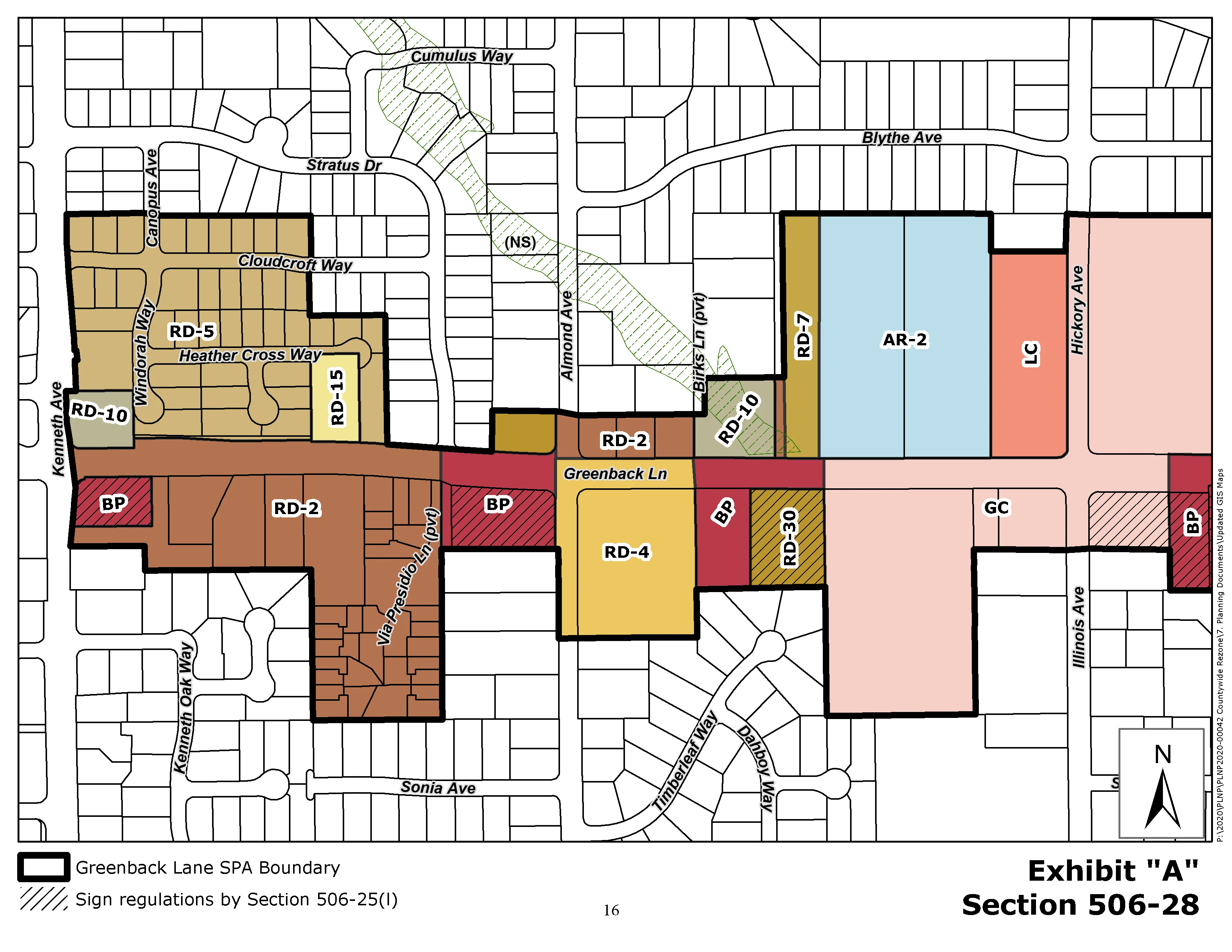
EXHIBIT “B”
Section titled “EXHIBIT “B””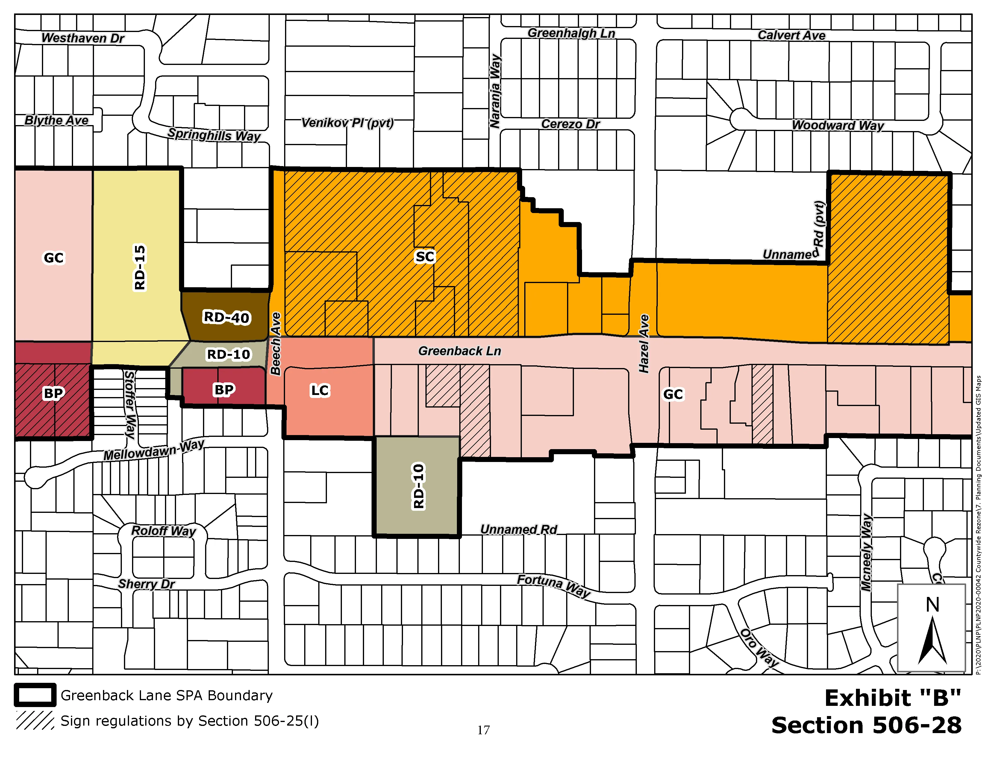
EXHIBIT “C”
Section titled “EXHIBIT “C””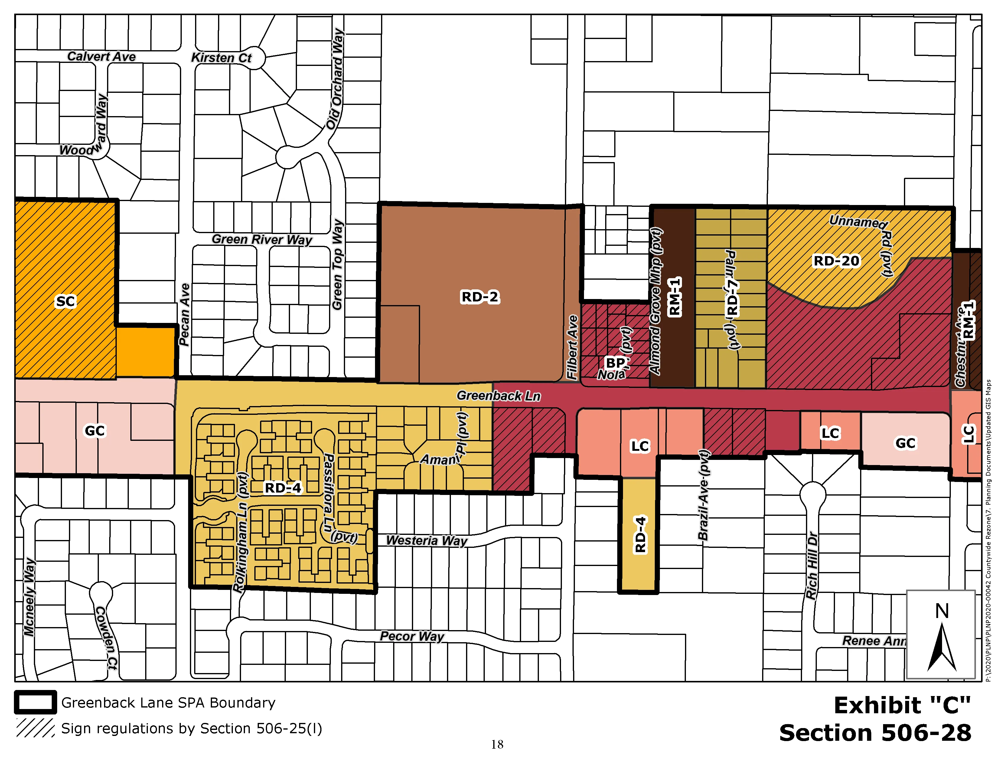
EXHIBIT “D”
Section titled “EXHIBIT “D””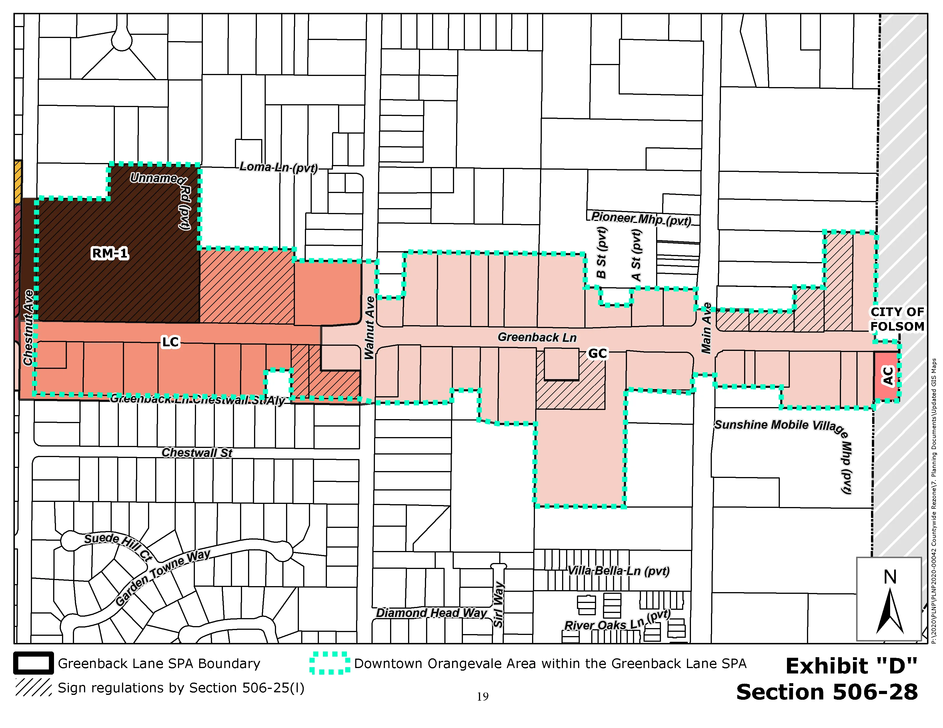
EXHIBIT “E”
Section titled “EXHIBIT “E””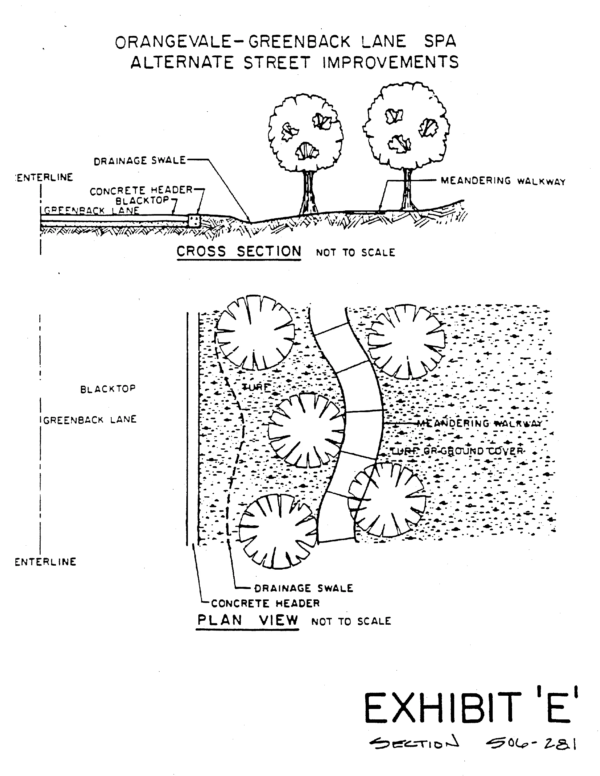
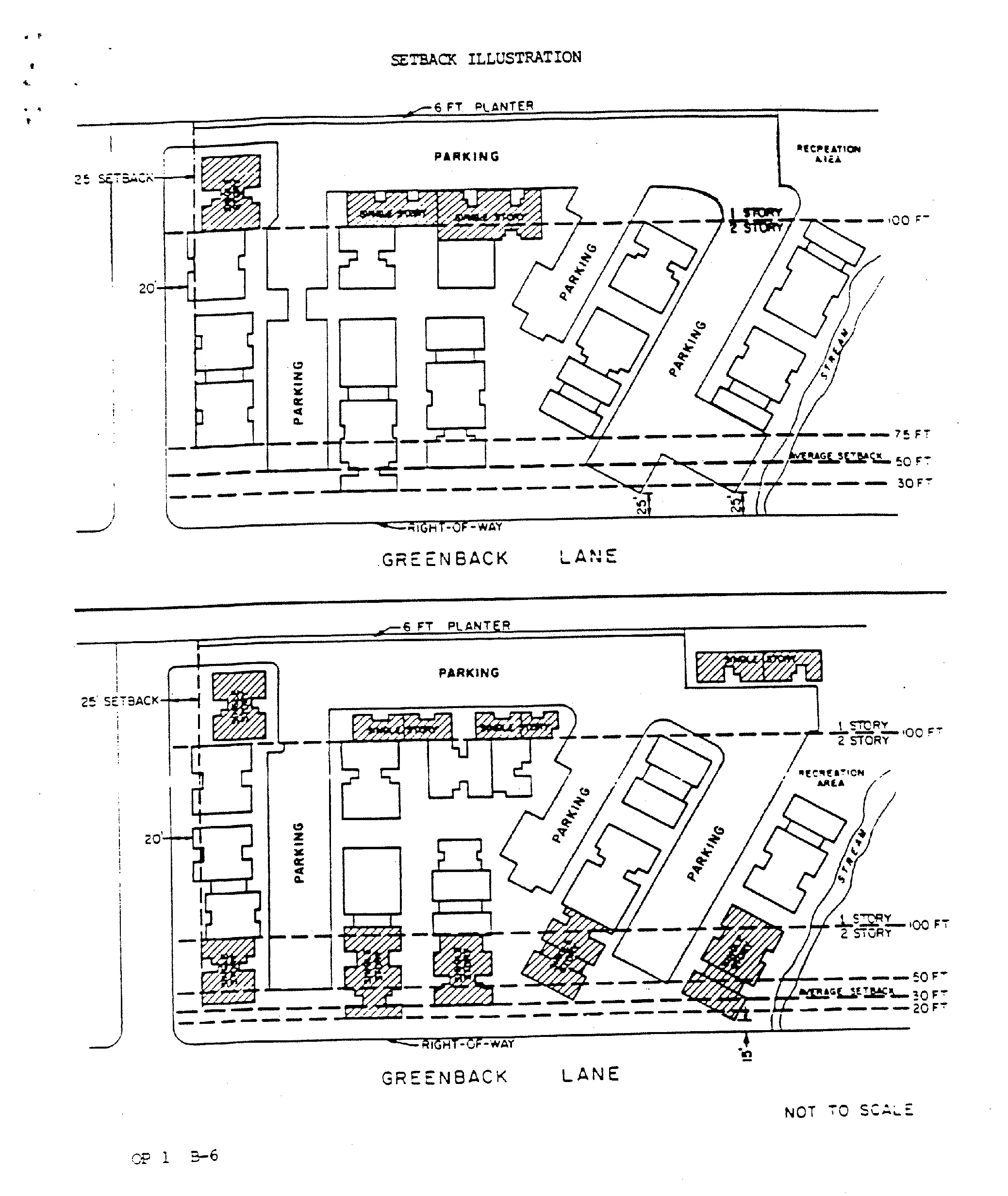
EXHIBIT “F”
Section titled “EXHIBIT “F””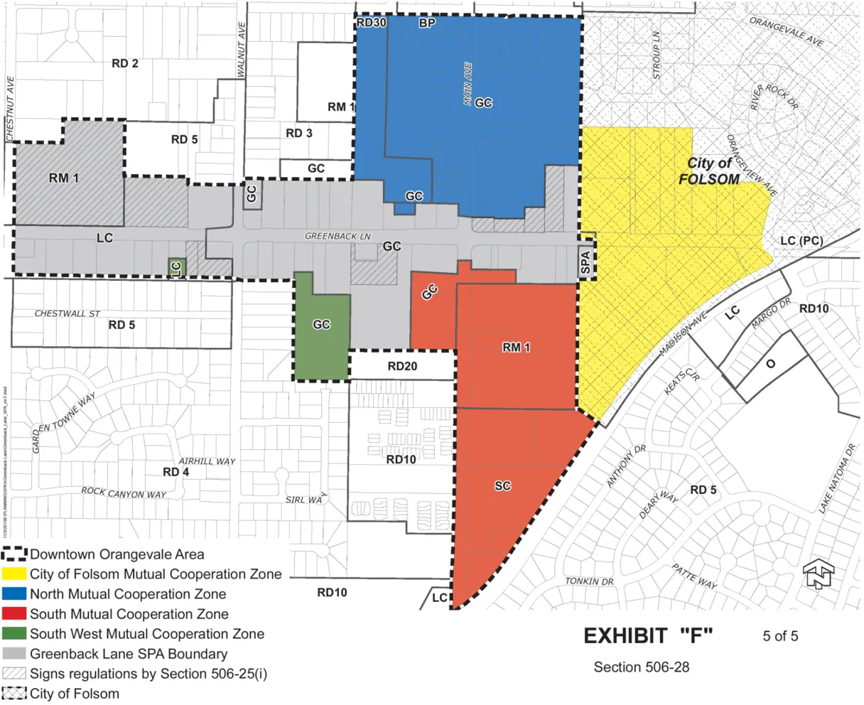
506-29. PERFORMANCE STANDARDS.
Section titled “506-29. PERFORMANCE STANDARDS.”The following Performance Standards are applicable to APN: 261-0210-005, approved through Control No. PLNP2009-RZB-SPP-PMR-DRS-00212).
- The subject parcel shall not have the following uses on-site as allowed under the Limited Commercial (LC) zoning (Section 3.2, Table 3.1 Commercial Use Tables, of the SCZC):
- Automotive Sales, Service, and Repair
- Funeral Establishment
- Tattoo Shop
- Wedding Chapel, Reception Hall
- Social Center
- Animal Kennels
- Laundromat, Self-Service
- Towing Service
- Appliance and Electronic Equipment Repair Services
- Bar/Tavern
- Drive-in Café
- Hotel/Motel
- Card Room
- Butcher and Meat Market
- Drive-in Dairy, Food Market, or Stand
- Drug Store
- Liquor Store
- Supermarket - Food Store
- Building Material and Lumber Sales
- Garage Equipment and Tool Sales
- Hardware Store
- Pawn Shop
- Recreation Equipment Sales
- Boat Sales and Service
- Motorcycle Sales and Service
- Manufacturing/Processing
- Storage/Recreational Vehicle Facilities
- Agricultural and Livestock Supplies
- Psychiatric/Rehabilitation Facilities
- Outdoor Equipment Sales and Supply
- Outdoor Recreation Facility
- Machine Sales Shops
- Residential Uses (Other than Senior Housing with a Use Permit, as applicable).
- Schools
- Transportation Facilities and Services
- Agricultural and Livestock Supplies
- If residential uses occur on the subject parcel, prior to approval of Development Plan Review or Use Permits for residential units, the property shall annex into the County of Sacramento Community Facilities District No. 2005-1 (Police Services). The annexation process takes approximately 6 months and the applicants must contact the County of Sacramento Infrastructure Finance Section at (916) 874-6525 at the earliest possible time to initiate the process and to obtain information concerning annexation costs.' (Sacramento County Community Development Department - Planning and Environmental Review Division)
- Comply with Conditions for Special Development Permit Control no. PLNP2012-ZOB-SPP-DRS00141. (Note: conditions relating to the Oak Grove Professional Center have been deleted from the SPA).
506-30. PERFORMANCE STANDARDS.
Section titled “506-30. PERFORMANCE STANDARDS.”The following Performance Standards are applicable to APN: 261-0210-020, approved through Control No. PLNP2016-00483).
- The subject parcel is designated as LC and all uses as permitted or conditionally permitted in the Zoning Code shall be allowed with the exception of the prohibited uses outlined below:
- Mobile Home Park
- Condominium Conversions
- Boarding House
- Fraternity/Sorority House
- College, University
- Hospital
- Solar Energy Facility
- Wind Turbine Facility
- Fortune Teller
- Bar/Tavern
- Adult Business: Adult Novelty Store
- Card Room
- Live/Motion Picture Theater and Performing Arts Center
- Nightclub, Dance Club, or Hall
- Hookah / Smoking / Vape Lounges
- Bed and Breakfast Inn
- Hotel, Motel
- General Retail Sales greater than 350,000 square feet
- Pawn Shop
- Thrift / Consignment
- Automobile Repair, Major
- Automobile Repair, Minor
- Comply with Conditions of Approval for Control No. PLNP2016-00483. Condition/Mitigation Measure and Responsible Agency The conditions are formatted with the Responsible Agency as headings. The timing or implementation of the condition is at the beginning of the condition in ALL CAPITAL LETTERS.
Sacramento County, Office of Planning and Environmental Review (PER)
- This action does not relieve the applicant of the obligation to comply with all ordinances, statutes, regulations, and procedures.
- Development of the site is limited to the permitted and conditionally permitted uses listed in Attachment 3 and as incorporated into the amended Greenback Lane Special Planning Area (Sacramento County Code Title V 506-20).
- Prior to SITE DEVELOPMENT: Prior to site development, the developer shall coordinate with the property owner to the north of the project site (APN 261-0210021) regarding desired location and height of masonry wall, and provide written verification to the Office of Planning and Environmental Review. Wall height shall not exceed 10 feet. However, ultimate wall height and location is at the discretion of the Planning Director as determined through the Design Review Process.
Attachment A: Environmental Mitigation Measures for Greenback Lane, East of Chestnut Avenue
Section titled “Attachment A: Environmental Mitigation Measures for Greenback Lane, East of Chestnut Avenue”MITIGATION MEASURE A: OAK TREE REMOVAL (STREETSCAPE MASTER PLAN/FUTURE PROJECT DEVELOPMENT WITHIN SPA AREA)
Section titled “MITIGATION MEASURE A: OAK TREE REMOVAL (STREETSCAPE MASTER PLAN/FUTURE PROJECT DEVELOPMENT WITHIN SPA AREA)”Prior to ground disturbing activities within 50 feet of native trees within the SPA area, the project proponent(s) shall submit an arborist report for the project impact. The report shall include the species, diameter, dripline, and health of the trees, and shall be prepared by an ISA certified arborist. The report shall include an exhibit that shows the trees and their dripline in proximity to the project improvements. The report shall identify any tree that will be removed and quantify the dripline encroachment from project equipment or facilities.
Any substantial (>20%) encroachment and/or removal of native oak trees shall be compensated by planting native trees (valley oak/ Quercus lobata , interior live oak/ Quercus wislizenii , blue oak/ Quercus douglasii , and California black walnut), equivalent to the dbh inches lost, based on the ratios listed below, at locations that are authorized by the Division of Planning and Environmental Review. On-site preservation of native oak trees that are less than 6 inches (<6 inches) dbh, may also be used to meet this compensation requirement. Encroachment of over 20 percent within the dripline radius of native trees will require compensatory mitigation based on the percentage of encroachment multiplied by the dbh. Encroachment over 50 percent will require compensation for the entire tree.
Equivalent compensation based on the following ratio is required:
- one preserved native oak tree < 6 inches dbh on-site = 1 inch dbh
- one ‘deepot’ seedling (40 cubic inches or larger) = 1 inch dbh
- one 15-gallon tree = 1 inch dbh
- one 24-inch box tree = 2 inches dbh
- one 36-inch box tree = 3 inches dbh
Replacement tree planting shall be completed prior to the issuance of building permits or a bond shall be posted by the applicant in order to provide funding for purchase, planting, irrigation, and 3year maintenance period, should the applicant default on replacement tree mitigation. The bond shall be in an amount equal to the prevailing rate of the County Tree Preservation Fund. Prior to the approval of Improvement Plans or building permits, a Replacement Oak Tree Planting Plan shall be prepared by a certified arborist or licensed landscape architect and shall be submitted to the Environmental Coordinator for approval. The Replacement Oak Tree Planting Plan(s) shall include the following minimum elements:
-
Species, size and locations of all replacement plantings and < 6-inch dbh trees to be preserved;
-
Method of irrigation;
-
The Sacramento County Standard Tree Planting Detail L-1, including the 10-foot deep boring hole to provide for adequate drainage;
-
Planting, irrigation, and maintenance schedules;
-
Identification of the maintenance entity and a written agreement with that entity to provide care and irrigation of the trees for a 3-year establishment period, and to replace any of the replacement oak trees which do not survive during that period.
-
Designation of 20-foot root zone radius and landscaping to occur within the radius of oak trees < 6-inches dbh to be preserved on-site.
No replacement tree shall be planted within 15 feet of the driplines of existing oak trees or landmark size trees that are retained on-site, or within 15 feet of a building foundation or swimming pool excavation. The minimum spacing for replacement oak trees shall be 20 feet on-center. Examples of acceptable planting locations are publicly owned lands, common areas, and landscaped frontages (with adequate spacing). Oak trees <6 inches dbh to be retained on-site shall have at least a 20-foot radius suitable root zone. The suitable root zone shall not have impermeable surfaces, turf/lawn, dense plantings, soil compaction, drainage conditions that create ponding, utility easements, or other overstory tree(s) within 20 feet of the tree to be preserved. Trees to be retained shall be determined to be healthy and structurally sound for future growth, by an ISA Certified Arborist subject to Department of Environmental Review and Assessment approval.
If oak tree replacement plantings are demonstrated to the satisfaction of the Environmental Coordinator to be infeasible for any or all trees removed, then compensation shall be through payment into the County Tree Preservation Fund. Payment shall be made at a rate of $325.00 per dbh inch removed but not otherwise compensated, or at the prevailing rate at the time payment into the fund is made.
MITIGATION MEASURE B: OAK TREE PROTECTION (STREETSCAPE MASTER PLAN/FUTURE PROJECT DEVELOPMENT WITHIN SPA AREA)
Section titled “MITIGATION MEASURE B: OAK TREE PROTECTION (STREETSCAPE MASTER PLAN/FUTURE PROJECT DEVELOPMENT WITHIN SPA AREA)”All healthy native trees that are 6 inches dbh or larger within the project area, all portions of adjacent off-site healthy native oak trees that are 6 inches dbh or larger which have driplines that extend onto the project site, and all off-site healthy native oak trees that are 6 inches dbh or larger which may be impacted by utility installation and/or improvements associated with this project, shall be preserved and protected as follows:
-
A circle with a radius measurement from the trunk of the tree to the tip of its longest limb shall constitute the dripline protection area of the tree. Limbs must not be cut back in order to change the dripline. The area beneath the dripline is a critical portion of the root zone and defines the minimum protected area of the tree. Removing limbs which make up the dripline does not change the protected area.
-
Any protected trees on the site that require pruning shall be pruned by a certified arborist prior to the start of construction work. All pruning shall be in accordance with the American National Standards Institute (ANSI) A300 pruning standards and the International Society of Arboriculture (ISA) ‘Tree Pruning Guidelines.’
-
Prior to initiating construction, temporary protective fencing shall be installed at least one foot outside the driplines of the protected trees within 100-feet of construction related activities, in order to avoid damage to the tree canopies and root systems. Where encroachment occurs, temporary high visibility protective fencing shall be installed a maximum of one foot outside the work areas in order to minimize damage to the tree canopies and root systems.
-
Chain link fencing or a similar protective barrier shall be installed one foot outside the driplines of the protected trees prior to initiating project construction, in order to avoid damage to the trees and their root systems. Where encroachment is being allowed for pedestrian improvements within the driplines of native trees, prior to initiating construction, protective fencing shall be installed a maximum of one foot outside the work areas in order to minimize damage to the tree canopy and root system.
-
Any removal of paving or structures (i.e. demolition) that occurs within the dripline of a protected oak tree shall be done under the direct supervision of a certified arborist. To the maximum extent feasible, demolition work within the dripline protection area of the protected tree shall be performed by hand. If the certified arborist determines that it is not feasible to perform some portion(s) of this work by hand, then the smallest/lightest weight equipment that will adequately perform the demolition work shall be used.
-
No signs, ropes, cables (except those which may be which may be installed by a certified arborist to provide limb support) or any other items shall be attached to the protected trees. Small metallic numbering tags for the purpose of preparing tree reports and inventories shall be allowed.
-
No vehicles, construction equipment, mobile home/office, supplies, materials or facilities shall be driven, parked, stockpiled or located within the driplines of protected trees.
-
No grading (grade cuts or fills) shall be allowed within the driplines of protected trees, except for the minimum required for construction and streetscape improvements.
-
Drainage patterns on the site shall not be modified so that water collects or stands within, or is diverted across, the dripline of any protected tree.
-
The construction of impervious surfaces within the driplines of protected trees shall be stringently minimized. When it is absolutely necessary, a piped aeration system per County standard detail shall be installed under the supervision of a certified arborist.
-
Any soil disturbance (scraping, grading, trenching, and excavation) is to be avoided within the dripline of the oak protected. Where this is necessary, an ISA Certified Arborist will provide specifications for this work, including methods for root pruning, backfill specifications and irrigation management guidelines.
-
The installation of pedestrian improvements within driplines of native trees shall be installed utilizing techniques developed to protect and preserve roots to the maximum extent possible. Structural soils, rubberized sidewalks, at or above grade construction, pervious concrete or other methods approved by the environmental coordinator shown to minimize impacts to root zones shall be employed during the installation of pedestrian facilities and roadway improvements.
-
Before grading, excavation or trenching within five feet outside the driplines of protected trees, root pruning shall be required at the limits of grading or excavation to cut roots cleanly to a depth of the excavation or 36 inches (whichever is less). Roots shall be cut by manually digging a trench and cutting exposed roots with a saw, vibrating knife, rock saw, narrow trencher with sharp blades or other approved root-pruning equipment under the supervision of an ISA Certified Arborist.
-
To the greatest extent feasible, all underground utilities and drain or irrigation lines shall be routed outside the driplines of oak trees. If lines must encroach upon the dripline, they should be tunneled or bored under the tree under the supervision of a certified arborist.
-
Any herbicides placed under paving materials must be safe for use around trees and labeled for that use. Any pesticides used on site must be tree-safe and not easily transported by water.
-
No sprinkler or irrigation system shall be installed in such a manner that it sprays water within the dripline of the protected tree.
-
Tree pruning required for clearance during construction must be performed by an ISA Certified Arborist or Tree Worker.
-
Landscaping beneath the protected trees may include non-plant materials such as bark mulch, boulders, decorative rock, wood chips, organic mulch, non-compacted decomposed granite, etc. Landscape materials shall be kept two (2) feet away from the base of the trunk. The only plant species which shall be planted within the dripline of the protected tree are those which are tolerant of the natural semi-arid environs of the trees. Limited drip irrigation approximately twice per summer is recommended for the understory plants.
Mitigation Measure C: Surface Waters (Streetscape Master Plan/Future Project Development within SPA Area)
Section titled “Mitigation Measure C: Surface Waters (Streetscape Master Plan/Future Project Development within SPA Area)”In order to reduce impacts to potential surface water habitat on Assessor’s Parcel Number (APN): 2230171-045, comply with one or a combination of the following:
- Total Avoidance: Construction fencing shall be installed a minimum of 50 feet from the swale/open waterway. All construction activities are prohibited within this buffer area. If total avoidance is achieved, no further action is required.
- Partial avoidance: ( If the Streetscape Master Plan project or future development on the site is designed to avoid encroaching within the open waterway/swale, but is within 50 feet of the boundaries). In such a case, construction fencing shall be installed at the limits of construction. Regardless of the construction season, this shall be supplemented by straw wattles (or similar) and silt fencing.
- Wetland Delineation/Compensate for habitat removed. Prior to any construction activities within the defined banks of the open waterway/swale on the project site, conduct a wetland delineation prepared by a qualified biologist. Depending on the results of the wetland delineation, obtain all applicable permits from the U.S. Fish and Wildlife Service, U.S. Army Corps of Engineers, California Department of Fish and Game, and the Central Valley Regional Water Quality Control Board for any proposed modifications to on-site surface waters and mitigate for habitat loss in accordance with the published regulatory guidelines.
Mitigation Measure D: Unanticipated Discoveries of Cultural Resources (Streetscape Master Plan/Future Project Development within SPA Area)
Section titled “Mitigation Measure D: Unanticipated Discoveries of Cultural Resources (Streetscape Master Plan/Future Project Development within SPA Area)”- If subsurface deposits believed to be cultural or human in origin are discovered during site preparation or construction activities, then all work must halt within a 200-foot radius of the discovery. A qualified professional archeologist, meeting the Secretary of the Interior’s Professional Qualification Standards for prehistoric and historic archaeology, shall be retained at the Applicant’s expense to evaluate the significance of the find. If it is determined due to the types of deposits discovered that a Native American monitor is required, the Guidelines for Monitors/Consultants of Native American Cultural, Religious, and Burial Sites as established by the Native American Heritage Commission shall be followed, and the monitor shall be retained at the Applicant’s expense.
- Work shall not continue within the 200-foot radius of the discovery site until the archaeologist conducts sufficient research and data collection to make a determination that the resource is either 1) not cultural in origin; or 2) not potentially eligible for listing on the National Register of Historic Places or California Register of Historical Resources.
- If a potentially-eligible resource is encountered, then the archeologist, and the project proponent shall coordinate with Sacramento County Planning and Environmental Review Division (PER), and arrange for either 1) total avoidance of the resource, if possible; or 2) test excavations or total data recovery as mitigation. The determination shall be formally documented in writing and submitted to PER as verification that the provisions of CEQA for managing unanticipated discoveries have been met.
- Section 5097.98 of the State Public Resources Code and Section 7050.5 of the State Health and Safety Code, in the event of the discovery of human remains, all work must stop and the County Coroner shall be immediately notified. If the remains are determined to be Native American, guidelines of the Native American Heritage Commission shall be adhered to in the treatment and disposition of the remains.
Mitigation Measure E: Contaminated Parcels Within the Plan Area (Streetscape Master Plan/Future Project Development within SPA Area)
Section titled “Mitigation Measure E: Contaminated Parcels Within the Plan Area (Streetscape Master Plan/Future Project Development within SPA Area)”- Prior to ground disturbing activities and/or acquisition of right-of-way on the following parcels: 223-0171-031, 223-0110-039, 223-0171-039, 223-0182-027, 223-0182-009, 223-0182-047, 223-0110-055, 223-0190-018, 223-0122-027, 223-0200-012, 223-0190-017, 223-0190009, 223-0190-008, 223-0200-044; 223-0200-017 submit either a Phase II Environmental Site Assessment or Soil Management Plan, as identified in Table IS-4, prepared to the satisfaction of the Sacramento County Environmental Management Department (EMD).
- All necessary site remediation recommendations (from the submitted Phase II and/or Soil Management Plan) shall be included as construction notes on all project plans, specifications and construction bid documents.
Mitigation Measure F: Streetscape Master Plan Contingency Plan
Section titled “Mitigation Measure F: Streetscape Master Plan Contingency Plan”The Sacramento County Department of Transportation (SacDOT) shall develop a contingency plan in the event that construction activities related to the project’s Streetscape Master Plan encounter unforeseen contamination. This plan should include: EMD and County Counsel coordination, contamination characterization and remediation.
Mitigation Measures as follows: Comply with the Mitigation Monitoring and Reporting Program (MMRP) for this project
All onsite trees and adjacent off-site trees 6 inches in dbh or larger which may be impacted by utility installation and/or improvements associated with this project, shall be preserved and protected as follows; with the exception of Tree 61, Tree 147, and any additional trees approved for removal or encroachment through an
(4) MITIGATION MEASURE A: TREE PROTECTION approved Tree Permit:
Section titled “(4) MITIGATION MEASURE A: TREE PROTECTION approved Tree Permit:”- A circle with a radius measurement from the trunk of the tree to the tip of its longest limb, plus one foot, shall constitute the critical root zone protection area of each protected tree. Limbs must not be cut back in order to change the dripline. The area beneath the dripline is a critical portion of the root zone and defines the minimum protected area of each protected tree. Removing limbs that make up the dripline does not change the protected area.
- Any protected trees on site which require pruning shall be pruned by an ISA Certified Arborist prior to the start of construction work. All pruning shall be in accordance with the American National Standards Institute (ANSI) A300 pruning standards, ANSI Standard 2133.1-2000 regarding safety practices, and the International Society of Arboriculture (ISA) 'Tree Pruning Guidelines' and Best Management Practices.
- Prior to initiating construction, temporary protective fencing shall be installed at least one foot outside the root protection zone of the protected trees in order to avoid damage to the tree canopies and root systems. Fencing shall be installed in accordance with the approved fencing plan prior to the commencement of any grading operations or such other time as determined by the review body. The developer shall contact the Project Arborist and the Planning Department for an inspection of the fencing prior to commencing construction activities on site.
- Signs shall be installed on the protective fence in four (4) equidistant locations around each individual protected tree. The size of each sign must be a minimum of two (2) feet by two (2) feet and must contain the following language:
- WARNING: THIS FENCE SHALL NOT BE REMOVED OR RELOCATED WITHOUT WRITTEN AUTHORIZATION FROM THE COUNTY OF SACRAMENTO.
- Once approval has been obtained by the County of Sacramento Municipal Services Agency protective fencing shall remain in place throughout the entire construction period and shall not be removed, relocated, taken down or otherwise modified in whole or in part without prior written authorization from the Agency, or as deemed necessary by the Project Arborist to facilitate approved activities within the root protection zone.
- Any removal of paving or structures (i.e. demolition) that occurs within the dripline of a protected tree shall be done under the direct supervision of the Project Arborist. To the maximum extent feasible, demolition work within the dripline protection area of the protected tree shall be performed by hand. If the Project Arborist determines that it is not feasible to perform some portion(s) of this work by hand, then the smallest/lightest weight equipment that will adequately perform the demolition work shall be used.
- No signs, ropes, cables (except those which may be installed by an ISA Certified Arborist to provide limb support) or any other items shall be attached to the protected trees. Small metallic numbering tags for the purpose of identification in preparing tree reports and inventories shall be allowed.
- No vehicles, construction equipment, mobile homes/office, supplies, materials or facilities shall be driven, parked, stockpiled or located within the driplines of protected trees.
- Drainage patterns on the site shall not be modified so that water collects, stands or is diverted across the dripline of any protected tree.
- No trenching shall be allowed within the driplines of protected trees, except as specifically approved by the Planning Department as set forth in the project's Conditions of Approval and/or approved tree permit. If it is absolutely necessary to install underground utilities within the dripline of a protected tree the utility line within the protected zone shall be 'bored and jacked' or performed utilizing hand tools to avoid root injury under the direct supervision of the Project Arborist.
- Grading within the protected zone of a protected tree shall be minimized. Cuts within the protected zone shall be maintained at less than 20% of the critical root zone area. Grade cuts shall be monitored by the Project Arborist. Any damaged roots encountered shall be root pruned and properly treated as deemed necessary by the Project Arborist.
- Minor roots less than one (1) inch in diameter encountered during approved excavation and/or grading activities may be cut, but damaged roots shall be traced back and cleanly cut behind any split, cracked or damaged area as deemed necessary by the Project Arborist.
- Major roots greater than one (1) inch in diameter encountered during approved excavation and/or grading activities may not be cut without approval of the Project Arborist. Depending upon the type of improvement being proposed, bridging techniques or a new site design may need to be employed to protect the roots and the tree.
- Cut faces, which will be exposed for more than 2-3 days, shall be covered with dense burlap fabric and watered to maintain soil moisture at least on a daily basis (or possibly more frequently during summer months). If any native ground surface fabric within the protected zone must be removed for any reason, it shall be replaced within forty-eight (48) hours.
- If fills exceed 1 foot in depth up to 20% of the critical root zone area, aeration systems may serve to mitigate the presence of the fill materials as determined by the Project Arborist.
- When fill materials are deemed necessary on two or three sides of a tree it is critical to provide for drainage away from the critical root zone area of the tree (particularly when considering heavy winter rainfalls). Overland releases and subterranean drains dug outside the critical root zone area and tied directly to the main storm drain system are two options.
- In cases where a permit has been approved for construction of a retaining wall(s) within the protected zone of a protected tree the applicant will be required to provide for immediate protection of exposed roots from moisture loss during the time prior to completion of the wall. The retaining wall within the protected zone of the protected tree shall be constructed within seventy-two (72) hours after completion of grading within the root protection zone.
- The construction of impervious surfaces within the dripline of a protected tree shall be minimized. When necessary, a piped aeration system shall be installed under the direct supervision of the Project Arborist.
- Preservation devices such as aeration systems, tree wells, drains, special paving and cabling systems must be installed in conformance with approved plans and certified by the Project Arborist.
- No sprinkler or irrigation system shall be installed in such a manner that sprays water or requires trenching within the dripline of a protected tree. An above ground drip irrigation system is recommended. An independent lowflow drip irrigation system may be used for establishing drought-tolerant plants within the protected zone of a protected tree. Irrigation shall be gradually reduced and discontinued after a two (2) year period.
- All portions of permanent fencing that will encroach into the protected zone of a protected tree shall be constructed using posts set no closer than ten (10) feet on center. Posts shall be spaced in such a manner as to maximize the separation between the tree trunks and the posts in order to reduce impacts to the tree(s).
- Landscaping beneath native oak trees may include non-plant materials such as bark mulch, wood chips, boulders, etc. Planting live material under protected native oak trees is generally discouraged, and is not recommended within six (6) feet of the trunk of a native oak tree with a diameter a breast height (DBH) of eighteen (18) inches or less, or within ten (10) feet of the trunk of a native oak tree with a DBH of more than eighteen (18) inches. The only plant species which shall be planted within the dripline of native oak trees are those which are tolerant of the natural, semi-arid environs of the tree(s).
- Maintenance measures identified in the Arborist Report prepared by Acorn Arboricultural Services, Inc dated April 26, 2017 and included as Appendix C of the Initial Study shall be completed to the satisfaction of the Office of Planning and Environmental Review.
(5) MITIGATION MEASURE B: NON-NATIVE TREE CANOPY PROTECTION
Section titled “(5) MITIGATION MEASURE B: NON-NATIVE TREE CANOPY PROTECTION”Removal of non-native tree canopy for development shall be mitigated by creation of new tree canopy equivalent to the acreage of non-native tree canopy removed. New tree canopy acreage shall be calculated using the Sacramento County Department of Transportation 15-year shade cover values for tree species. Preference is given to on-site mitigation, but if this is infeasible, then funding shall be contributed to the Sacramento Tree Foundation’s Greenprint program in an amount proportional to the tree canopy lost (as determined by the 15-year shade cover calculations for the tree species to be planted through the funding, with the cost to be determined by the Sacramento County Tree Foundation).
(6) MITIGATION MEASURE C: CULTURAL RESOURCES
Section titled “(6) MITIGATION MEASURE C: CULTURAL RESOURCES”To ensure protection of cultural resources, the following measure applies. This measure shall be included verbatim as a Construction Note on all Plans and Specifications for the project:
Should any cultural resources, such as structural features, unusual amounts of bone or shell, artifacts, human remains, or architectural remains be encountered during any development activities, work shall be suspended and the Planning and Environmental Review Division shall be immediately notified. At that time, the Planning and Environmental Review Division will coordinate any necessary investigation of the find with appropriate specialists as needed. The project proponent shall be required to implement any mitigation deemed necessary for the protection of the cultural resources.
In addition, pursuant to Section 5097.97 of the State Public Resources Code and Section 7050.5 of the State Health and Safety Code, in the event of the discovery of human remains, all work is to stop and the County Coroner shall be immediately notified. If the remains are determined to be Native American, guidelines of the Native American Heritage Commission shall be adhered to in the treatment and disposition of the remains.
Appendix A: Downtown Orangevale Commercial Design Guidelines
Section titled “Appendix A: Downtown Orangevale Commercial Design Guidelines”Download the Downtown Orangevale Commercial Design Guidelines.
Appendix B: Downtown Orangevale Streetscape Master Plan
Section titled “Appendix B: Downtown Orangevale Streetscape Master Plan”Download the Downtown Orangevale Streetscape Master Plan. This is an archived PDF document.