Aerojet SPA
Sacramento County Zoning Code
Aerojet Special Planning Area Ordinance
Section titled “Sacramento County Zoning Code Aerojet Special Planning Area Ordinance”Adopted May 3, 1995
Amended September 10, 1997 & January 28, 2009 & January 12, 2021
Adopted by ZMA #5216 / 1993-CZB-ZOB-0124
Amended by 1996-ZOB-0628 & 2004-GPB-ZOB-SDP-AHS-0035 (Easton Place & Glenborough) & PLNP2019-00367 (Addition of 072-0100-020)
SECTION I: SPECIAL PLANNING AREA.
Section titled “SECTION I: SPECIAL PLANNING AREA.”Title V, Chapter 8, Article 3, is hereby added to the Zoning Code of Sacramento County (referred to herein as this “Code”) to add Sections 508-300 through 508-316, to read:
508-300. PROPERTY REGULATED.
Section titled “508-300. PROPERTY REGULATED.”This Ordinance applies to and regulates land use and development of all real property in that part of the unincorporated area of the County of Sacramento depicted in Section 508-313, Exhibit “A”, attached hereto and incorporated by reference into this Ordinance; provided, however, that:
- Addition and Deletion of Property. Subject to approval as set forth herein below, Aerojet shall have the option, exercisable at Aerojet's sole discretion, to (i) include within this Special Planning Area other properties in which Aerojet has acquired a possessory interest, including, but not limited to, an ownership or leasehold interest, provided such property is contiguous with this Special Planning Area and (ii) to remove specified properties from this Special Planning Area. Any application for the addition or deletion of property to or from this Special Planning Area shall depict, on an exhibit, any property to be added or deleted, the relationship of the property to this Special Planning Area and the permitted uses requested for such property. Such application shall be subject to notice and public hearing pursuant to Section 110-04 of this Code, and upon approval of such application by the Board of Supervisors, said property shall immediately and automatically be deemed added, or deleted, to or from this Special Planning Area, as the case may be, and the uses approved for said added property shall be deemed permitted uses thereof pursuant to Section 508-304 of this Ordinance; and
- Documentation. Any and all such documentation as may be necessary to represent any amendment or modification made pursuant to Subsection (a) above, shall be incorporated herein and made a part of this Code for all purposes.
508-301. INTENT.
Section titled “508-301. INTENT.”It is the intent of the Board of Supervisors in adopting this Special Planning Area Ordinance to develop a regulatory mechanism for land uses, existing and proposed, on the property described in Section 508-300 that allows for the use and development of the property in a manner that:
- recognizing Aerojet's right to continue, expand, reactivate, and relocate existing uses on the property within this Special Planning Area, maintains a safe environment in which the subject property can be used given the special facilities and uses historically conducted thereon: and
- permits, as specified in this Ordinance, residential, retail, research and development, office, recreational, community, commercial, surface mining, manufacturing, high technology industrial, intensive and extensive industrial development, including, but not limited to, manufacturing, production, testing, remanufacture, resource recovery, storage and disposal of ordnance, propulsion systems, propellants, energetic compounds and other chemical compounds, to occur in ways that are compatible with existing uses and surrounding uses; and
- permits the consolidation and restructuring of Aerojet facilities, including, but not limited to, the expansion, relocation, and reactivation of existing uses, (as specified in Section 508-304(a) hereof), new uses (as specified in Section 508-304(b) and (c) hereof), and the planning of future development, pursuant to a Land Use Master Plan, as defined herein below (as specified in Section 508-304(d) hereof), for all or any portion of the subject property within this Special Planning Area; and
- allows the processing, from time to time, of one or more applications for any Land Use Master Plan, as defined herein below, for all or any portion of the subject property, which Land Use Master Plan will entitle uses of property not related to the historical uses thereof; and
- allows the filing and processing, from time to time, of one or more applications for uses that are not related to the historical uses of the property within this Special Planning Area as specified in Sections 508-304(b), (c) and (d) and Section 508-305 hereof); and
- allows any actions or activities that may be taken by the property owner as regulated under federal, state or local laws, statutes, ordinances, rules or regulations with respect to activities on, or uses of, the property as well as any actions resulting from contracts of the United States Government or any agency thereof, and does not expand the regulatory oversight of the County with respect to such actions, activities, uses or contracts.
508-302. EXHIBITS.
Section titled “508-302. EXHIBITS.”Section 508-313 consisting of Exhibits “A” through “317-F” attached to this Ordinance, is incorporated herein and made a part of this Ordinance for all purposes.
508-303. DEFINITIONS.
Section titled “508-303. DEFINITIONS.”The terms used herein are defined for purposes of this Ordinance only, and are intended to be understood herein in the sense of these following definitions, and are not intended to create new terms or alter the meaning of the following terms with respect to any other part of this Code, or with respect to any other law, statute, ordinance, rule or regulation.
- "Aerojet" means Aerojet-General Corporation, an Ohio Corporation, and the parent company, affiliates, divisions, units and plants of Aerojet-General Corporation, including, but not limited to, the successors and assigns and the Sacramento operations thereof that may, from time to time, own, occupy or operate the property and the facilities within this Special Planning Area.
- "Building Permit Agreement" means that certain building permit agreement dated September 17, 1991, by and between the County (as adopted by Resolution no. 91-1474 of the Board of Supervisors) and Aerojet Propulsion Division (APD), and such building permit agreement between Aerojet-General Corporation and Sacramento County Fire Protection District dated January 9, 1997, as the same may be amended or restated from time to time.
- "Existing Uses" means all uses existing within the subject property as of the date of this Ordinance, and all uses conducted at any time prior to the effective date of this Ordinance that are determined pursuant to Section 508-304(a) hereof to have historically been permitted uses of the subject property, wherever such uses may, from time to time, be located on the subject property, including, but not limited to (i) the net approximately 4.6 million square feet of office uses (ii) research, and design, development, production, electrolytic processing, manufacture, testing, repair, remanufacture, storage, decommissioning, treatment and disposal of ordinance, propulsion systems, liquid and solid propellants, energetic compounds, explosives, and other chemical compounds (including by way of example and not limitation, oxidizers, acids, light metal hydrides, oxygen, flourins, and pharmaceuticals), metal parts (including by way of example and not limitation, casting, deed drawing and other means of forming), and plastics, resins, and similar products, (iii) the generation, storage, transfer, treatment, resource recovery and recycling of wastes and hazardous materials and the disposal of generated wastes and hazardous and non-hazardous materials.
- "Improvement" means, but is not limited to, any building, structure, container, storage, tank, pipeline, pond, lagoon, dry well, landfill, treatment and disposal unit or impoundment.
- "Land Use Master Plan" means any conceptual land use plan, such as any tentative map, or any Specific Plan, as defined elsewhere in this Code, submitted by the property owner for a development project (as specified in Section 508-307 hereof).
- "New Use" means any new development or new improvement within this Special Planning Area after the effective date of this Ordinance, including, but not limited to, uses permitted pursuant to an approved Land Use Master Plan as specified in Sections 508-304(d) and 508-307, provided, however, recognizing that Aerojet has the right to reactivate, relocate, restructure, modify, expand and renovate its existing uses of the subject property commensurate with its historical uses thereof, "New Use" for the purposes of this Ordinance shall not include any (i) closure, reactivation, relocation, restructure, modification, expansion or renovation of an existing or previously existing, use or improvement within this Special Planning Area, or any (ii) change in use, reactivation, relocation, restructure, expansion, renovation or the development of any improvement classified as "Secret" or "Top Secret" by the United States Government; or any (iii) development, improvement or expansion, modification or relocation of any existing improvement or existing use of the property within this Special Planning Area that (1) is owned or operated by the United States Government, or (2) conducted pursuant to any contract of Aerojet with the United States Government; or any (iv) incidental use or accessory use; or any (v) modification to an existing Resource Conservation and Recovery Act (RCRA) interim status or hazardous waste management permit that has been approved by the California Department of Toxic Substances Control (DTSC) or the United States Environmental Protection Agency (USEPA): or any (vi) closure, reactivation, relocation, restructure, modification, expansion or renovation of an existing or previously existing use or improvement within this Special Planning Area designated for the remediation or other treatment of groundwater, including, but not limited to, groundwater that may be brought onto this Special Planning Area from off-site extraction wells or sources for remediation or other required treatment as approved by the USEPA or the California Central Valley Regional Water Quality Control Board (the "Regional Board"). Notwithstanding the foregoing, the importation to this Special Planning Area of hazardous wastes (as defined by RCRA) generated outside this Special Planning Area, with the exception of groundwater brought onto the site from off-site extraction wells or other sources for remediation or other required treatment as provided in this subparagraph (vi), shall be considered a new use subject to issuance of a conditional use permit.
508-304. PERMITTED USES.
Section titled “508-304. PERMITTED USES.”Uses on any portion of the property described in Section 508-300 and permitted as a matter of right are as follows:
- Existing Uses
All existing uses shall be deemed permitted uses within this Special Planning Area as a matter of right requiring only the issuance of a building permit. The following existing uses are subject to the following special conditions:
- Propulsion Systems Testing
Aerojet’s permitted uses of the subject property within this Special Planning Area necessitate the conduct of periodic hot fire propulsion systems testing activities that generate significant levels of visible emissions, pressure and noise. Notwithstanding subsections (b) and (c) below, and except as otherwise provided pursuant to Section 508-304(d) hereof, static firing of propulsion devices shall be permitted in this Special Planning Area where appropriate or required, consistent with applicable United States Department of Defense quantity/distance criteria for such testing.
- Routine Component Testing
Aerojet’s permitted uses of the subject property within this Special Planning Area related to the process of manufacturing necessitate the conduct of routine component testing activities. Notwithstanding subsections (b) and (c) below, and except as otherwise provided pursuant to Section 508-304(d) hereof, the conduct of routine component testing activities shall be permitted in this Special Planning Area where appropriate or required, consistent with applicable United States Department of Defense quantity/distance criteria for such testing.
- Office Uses
Aerojet’s permitted uses of the subject property within this Special Planning Area permit Aerojet to reactivate, relocate, restructure, modify, expand and renovate its office uses commensurate with its historical uses. Notwithstanding subsections and (c) below and except as otherwise provided pursuant to Section 508- 304(d) hereof, or the approval of one or more Land Use Master Plans pursuant to Section 508-307 hereof, the total net office uses, wherever such office uses may, from time to time, be located on the property within this Special Planning Area shall not exceed the net approximately 4.6 million square feet of existing office uses (as defined in Section 508-303(c) hereof). Any reactivated or relocated office use shall be (a) within the Administrative Area of the subject property, which is depicted in Section 508-313, Exhibit ” B” of this Special Planning Area Ordinance, or (b), if located outside said administrative area, the total net office uses outside said administrative area shall not exceed 250,000 square feet and shall be located within areas of the subject property that have been historically used for office purposes. If such office use exceeds said 4.6 million square feet within said administrative area or exceeds said 250,000 square feet outside of said administrative area within areas that have been historically used for office purposes, it is considered a new use and is subject to issuance of a conditional use permit pursuant to Section 508-305 hereof, except as may otherwise be provided pursuant to the approval of one or more Land Use Master Plans pursuant to Section 508-307 hereof. Relocated office uses shall not be located within 500 feet of the White Rock Road Special Planning Area without the issuance of a conditional use permit or, alternatively, the approval of one or more Land Use Master Plans.
- Propulsion Systems Testing
- Industrial Zone
New Uses permitted in the Industrial Zone as depicted in Section 508-313, Exhibit “B” attached hereto (the “Industrial Zone”) are all uses listed as permitted or conditional uses on Exhibit “C” attached hereto, in addition to those uses provided for in Section 508-304(a) hereof and those uses permitted pursuant to one or more approved Land Use Master Plans as specified in Sections 508-304(d) and 508-307 hereof. To the extent that uses are added to the Industrial Use Tables of this Code for the M-1 Light Industrial Zone (as defined in this Code), the M-2 Heavy Industrial Zone (as defined in this Code), and the Commercial Uses Tables of this Code for the MP Industrial-Office Park Zone (as defined in this Code), the Planning Director shall determine whether such added uses are sufficiently similar to the uses permitted pursuant to Exhibit “C” hereof to be permitted pursuant to this Section 508-304(b) or whether such uses shall be subject to the issuance of a conditional use permit pursuant to Section 508-305 hereof. Other uses listed in the Commercial Uses Tables are permitted upon the issuance of a conditional use permit by the appropriate authority; provided, however, no conditional use permit shall be issued for any residential uses listed in said Commercial Use Tables unless and until a Master Land Use Plan that permits such residential uses has been developed and approved pursuant to Section 508-307 hereof.
- Industrial Border Zone
New Uses permitted in the Industrial Border Zone, being that portion of the property that is depicted in Section 508-313, Exhibit “B”, are all those uses permitted under this Code for any Permanent Agricultural zone (AG-160, AG-80, AG-20), in addition to those uses provided for in Section 508-304(a) hereof and those uses permitted pursuant to one or more approved Land Use Master Plans as specified in Sections 508-304(d) and 508-307 hereof.
- Future Development Areas
Notwithstanding the foregoing sections (a), (b), and (c), from time to time, based upon the business and operational needs of the property owner, and upon the approval of one or more Land Use Master Plans pursuant to Section 508-307 below for all or any portion of the property within this Special Planning Area, this Ordinance shall be modified so that the uses, design guidelines and development standards, if any, for any area described in any such approved Land Use Master Plans shall be incorporated into this Special Planning Area Ordinance
508-305. SIMILAR OR LIKE USES PERMITTED WITH A CONDITIONAL USE PERMIT.
Section titled “508-305. SIMILAR OR LIKE USES PERMITTED WITH A CONDITIONAL USE PERMIT.”In addition to the permitted uses specified in Section 508-304, if a use is requested by the property owner for a use not shown as a permitted use in Section 508-304 hereof, is permitted pursuant to Section 508-304 subject to the issuance of a conditional use permit, or is not specifically provided for in this Code, the Board of Supervisors authorizes the appropriate granting authority to grant a conditional use permit in accordance with the provisions of this Code, subject to the following:
- A finding by the granting authority that the use is substantially similar in characteristics, intensity, and compatibility to a use or uses permitted and applicable to the subject property pursuant to Section 508-304 hereof.
- A finding by the granting authority that the use would be appropriate in the zoning classification applicable to the subject property as a permitted or conditional use. Each such use shall conform to all regulations and conditions of approval applicable to the similar use that is applicable to the subject property (as specified in Section 508- 304 hereof), as well as the standards and provisions applicable to the similar uses as set forth in Title III of this Code.
508-306. USE REGULATIONS.
Section titled “508-306. USE REGULATIONS.”- Project review
Any New Use in this Special Planning Area that is not a permitted use pursuant to this Ordinance or is not a permitted use pursuant to one or more approved Land Use Master Plans shall be subject to Section 508-305. Any New Use in this Special Planning Area that is a permitted use pursuant to Section 508-304(b) or (c) this Ordinance, and not otherwise subject to the issuance of a conditional use permit pursuant to Sections 508-304(a) (3) or 508-304(b), or the approval of one or more Land Use Master Plans pursuant to Section 508-307, shall be subject only to ministerial review and approval by the Planning Director. Any determination necessary to verify whether a proposed use is a permitted use shall be made by the Planning Director within thirty (30) days from the date of the receipt by the County of such application.
- Building Permits
No building permit authorizing improvements in this Special Planning Area shall be issued except as specified in the Building Permit Agreement, as described in Section 508-303(b), or as required to implement an approved Conditional Use Permit or one or more approved Land Use Master Plans consistent with this Ordinance.
508-307. LAND USE MASTER PLANS.
Section titled “508-307. LAND USE MASTER PLANS.”The property owner may, from time to time, submit to the County a request for approval of a Land Use Master Plan, which may, but shall not necessarily include, a tentative map, or a Specific Plan, as defined elsewhere in this Code, for all or any portion of the property included within this Special Planning Area. Each and every such Land Use Master Plan shall comply with the requirements of the California Environmental Quality Act (CEQA) and be subject to the review and approval of the Policy Planning Commission and the Board of Supervisors. Notice of the hearing before the Planning Commission and the Board of Supervisors shall be as provided in Ch. 10, Art. I, Title I of this Code. A Land Use Master Plan shall contain, but shall not be limited to, (i) a conceptual land use plan indicating the location and acreage of proposed elements of the development, which may include all uses permitted by this Code or uses substantially similar to uses permitted by this Code, (ii) a phasing plan that identifies the sequence and timing of a proposed development, and (iii) development and performance standards.
The Policy Planning Commission shall use its reasonable best efforts to schedule for action any application for a Land Use Master Plan within ninety (90) days of the completion of the environmental review, if any, required for such a Land Use Master Plan. The Board of Supervisors shall use its reasonable best efforts to schedule a hearing to act upon the recommendation of the Policy Planning Commission respecting an application for any Land Use Master Plan within sixty (60) days from the date a recommendation is made by the Policy Planning Commission. Upon approval by the Board of Supervisors, the uses, design guidelines and development standards, if any, incorporated into any such approved Land Use Master Plan shall become a separate section of this Special Planning Area Ordinance and shall be a part hereof for all purposes.
508-308. APPEALS.
Section titled “508-308. APPEALS.”Appeals shall be in conformance with Chapter 15, Article 3 of Title 1 of this Code; provided, however, that the Board of Supervisors, rather than the Board of Zoning Appeals, shall hear and decide all appeals from the actions of the Planning Director under this Ordinance.
508-309. AMENDMENTS TO THIS SPECIAL PLANNING AREA ORDINANCE.
Section titled “508-309. AMENDMENTS TO THIS SPECIAL PLANNING AREA ORDINANCE.”The procedures for amending this Special Planning Area Ordinance shall be the same as for any amendment to the Zoning Code, as set forth in Title 1, Chapter 15, Article 2, including any such application pursuant to the provisions of Section 115-12 of this Code or any amendment, modification or replacement thereof.
508-310. PERFORMANCE AND DEVELOPMENT STANDARDS.
Section titled “508-310. PERFORMANCE AND DEVELOPMENT STANDARDS.”- Hazardous Materials Management
The historical and continuing roles of Aerojet as a defense/aerospace manufacturing entity, and a developer and producer of chemicals, subjects the property within this Special Planning Area to extensive regulation by federal, state and local authorities. The Board of Supervisors recognizes that certain actions and activities of the property owner, particularly with respect to, but not limited to, operations on the subject property that involve the management of hazardous materials or that are carried out in connection with contracts with the United States Government, are regulated under federal, state or local environmental laws, statutes, ordinances, rules or regulations. It is not the intent of this Ordinance to extend the regulatory oversight of the County to any such actions, activities, uses or contracts that are otherwise so regulated. Aerojet does, and shall continue to, use reasonable best efforts to establish and implement such policies, guidelines and procedures as are necessary and appropriate to manage its operations in compliance with applicable federal, state and local laws and regulations that govern the management of hazardous materials, as the same are amended, replaced or superseded from time to time. Historically, hazardous waste management on the property within this Special Planning Area has been limited to hazardous wastes (as defined by RCRA) generated within this Special Planning Area, and the importation to this Special Planning Area of hazardous wastes (as defined by RCRA) generated outside this Special Planning Area, with the exception of groundwater brought onto the site from off-site extraction wells or other sources for remediation or other required treatment as approved by the USEPA or the Regional Board, shall be considered a new use (as defined in Section 508-303(f)) subject to the issuance of a conditional use permit.
- Propellant and Explosive Storage
- External Perimeter.
Notwithstanding subsections (b) and (c) of Section 508-304 above, and except as otherwise provided pursuant to Subsection 508-304(d) above, the storage of propellants and explosives shall be located primarily, but not exclusively, within that area of the property that is, from time to time, designated for the storage of propellants and explosives (the “propellant and explosive storage area”). Aerojet does, and shall continue to, use its reasonable best efforts to comply with United States Department of Defense quantity/distance criteria for the storage of propellants and explosives. Consistent with the quantity/distance criteria pertaining to the handling of propellants and explosives contained in the Department of Defense Contractor’s Manual for Ammunition and Explosives (DOD Manual 4145.26-M) dated March 2008, Aerojet is authorized to generate overpressures not to exceed 1.00 pounds per square inch (PSI) at its external perimeter at any time. Notwithstanding that such overpressures are permitted, Aerojet has agreed to conduct its business in such a manner that overpressures generated, if any, will not exceed 0.50 PSI at its external perimeter. Aerojet has also agreed to conduct its business such that overpressures generated, if any, will not exceed 0.25 PSI on any of the facilities of the adjacent commercial and recreational use commonly known as The Mine Shaft, which commitment will continue for so long as such or similar land uses exist on that site.
- External Perimeter and Land Use Master Plan Areas
The external perimeter may be modified from time-to-time to accommodate Land Use Master Plan areas. Where a Land Use Master Plan area is approved, the external perimeter shall be the Industrial Zone boundary adjacent to the new Land Use Master Plan area. Compliance with the overpressure limits at this perimeter will be met prior to the issuance of occupancy permits for residential uses within the Land Use Master Plan area.
- External Perimeter.
- Air Emissions Management
Aerojet does, and shall continue to, use reasonable best efforts to establish and implement such policies, guidelines and procedures as are necessary and appropriate to manage its operations to comply with applicable federal, state and regional air quality standards, laws, regulations, ordinances, rules, permits and reporting requirements, as the same are amended, replaced or superseded from time to time.
- Regulatory Mandates and Court Orders
Nothing in this Ordinance shall alter or supersede the terms and conditions of that certain Partial Consent Decree and that certain 1994 Imminent and Substantial Endangerment Determination and Consent Order, as defined herein below, and in no event shall any on-site activity conducted pursuant to the Partial Consent Decree or the 1994 Imminent and Substantial Endangerment Determination and Consent Order be subject to any permit requirement of the County:
- Partial Consent Decree and Modifications Thereto
Portions of the subject property are subject to a federal court Partial Consent Decree (the “Decree”), entered in the Federal District Court in Sacramento, effective June 23, 1989 (CIVS-86-0064-EJG) respecting environmental conditions at, and related to, the Aerojet Propulsion Division facility. In addition, portions of the property are subject to a federal court order, entered in the Federal District Court in Sacramento, effective April 15, 2002 [CIVS-86-0063-EJG and CIVS-86-0064-EJG (Consolidated)] (the “Order”), creating “Carve-out Lands,” as described in the Order, being those lands removed from the Decree.
- Imminent and Substantial Endangerment Determination and Consent Orders
Portions of the subject property are subject to Imminent and Substantial Endangerment Determination and Consent Orders (the “ISEOs”) issued by DTSC on November 14, 1991 and on June 1, 1994. Such ISEOs were issued to Aerojet, as the current owner, and to McDonnell Douglas Company, as the previous owner and operator.
- Partial Consent Decree and Modifications Thereto
- Natural Resources
Recognizing Aerojet’s right to continue, expand and relocate existing uses on the property within this Special Planning Area, the property owner shall take into consideration the location of natural vegetation and trees, if any, and the flora, fauna, vernal pools and riparian habitats identified in surveys contained in that certain Environmental Assessment of the United States-Aerojet RCRA Facility Hazardous Waste Management Units prepared by ICF Technology Incorporated and dated December 1989, during the design of any Land Use Master Plan. For any proposed development or improvements that impact waters of the United States or endangered species (as defined by the laws of the United States and of the State of California), the property owner shall obtain permits, if any, required by the United States Army Corps of Engineers, the United States Fish and Wildlife Service, and the California Department of Fish and Game for the proposed use. The Director of Public Works, the Planning Director or their designee, in consultation with the County Department of Environmental Review and assessment (DERA), shall review applications for grading permits for projects within this Special Planning Area relative to the above-described natural resource considerations to assure the appropriate mitigation of impacts, if any.
- Public Services, Water Use and Discharge
Aerojet uses potable and industrial water supplied by the Water Department of the City of Folsom for the operations within the Industrial Zone. Other areas of the subject property within this Special Planning Area use water supplied by the Sunrise Water Maintenance District. Aerojet discharges domestic and industrial waste water into the regional sanitary sewer system of the Sacramento County Regional County Sanitation District pursuant to an Industrial Sewer Use Permit. Aerojet does, and shall continue to, use reasonable best efforts to establish and implement such policies, guidelines and procedures as are necessary and appropriate to manage water discharges within this Special Planning Area in compliance with the waste discharge requirements, National Pollutant Discharge Elimination System (NPDES) Permits, if any, issued respecting the subject property by the Regional Water Quality Control Board (RWQCB), and Industrial Sewer Use Permits, if any, issued respecting the subject property.
508-311. NOTICES.
Section titled “508-311. NOTICES.”Any County Notices shall be sent to Aerojet General Corporation pursuant to standard County notice procedures by United States mail to the following addresses:
GenCorp, Inc.
P.O. Box 537012
Sacramento, California 95813-7012
Attention: Chief Executive Officer
GenCorp
P.O. Box 537012
Sacramento, California 95813-7012
Attention: General Counsel
GenCorp
P.O. Box 537012
Sacramento, California 95813-7012
Attention: Vice-President, Real Estate
508-312. FINDINGS.
Section titled “508-312. FINDINGS.”In creating this Special Planning Area, the Board of Supervisors finds:
- That the area included within this Special Planning Area represents an important source of economic benefit for the county and that changes in the aerospace and defense industries require that the property owner be permitted to continue, expand, modify and relocate existing uses and establish new uses within this Special Planning Area as permitted in this Ordinance; and
- That this Ordinance provides a regulatory mechanism for making land use decisions that maintain a safe environment in which the subject property can be used given the special requirements of the property owner, Aerojet: and
- The development in such a manner as is described in subsection (b) cannot be effectively provided for with any other land use and its related development standards as described in this Code; and
- This Special Planning Area ordinance allows development of the site in a manner which is sensitive to the site's constraints and special features; and
- That this Special Planning Area Zone will provide for a reasonable use of the land and not cause undue hardship on the property owner
508-313. EXHIBITS.
Section titled “508-313. EXHIBITS.”The Exhibits to this Ordinance are as follows:
- Exhibit "A": Depicting the area encompassed by this Ordinance Amended January 21, 2021.
- Exhibit "B": Depicting certain designations within the SPA area Amended January 21, 2021.
- Exhibit "C": Listing the uses permitted pursuant to this Ordinance.
- Exhibit "D": Depicting the Carve-Out Area pursuant to the order, entered in the Federal District Court in Sacramento, effective April 15, 2002 [CIVS-86-0063-EJG and CIVS-86-0064-EJG (Consolidated)].
- Exhibit "E": Conditions - Easton Place and Glenborough.
- Exhibit "314-A": Depicting the Land Use Master Plan for "Glenborough at Easton."
- Exhibit "315-A": Depicting the Land Use Master Plan for "Easton Place."
- Exhibit "316-A": Easton Place Land Use Master Plan.
- Exhibit "316-B": Glenborough Land Use Master Plan.
- Exhibit "F": Conditions - Aerojet Waste Consolidation Unit
- Exhibit "317-A": Aerojet Waste Consolidation Unit Project Plan
- Exhibit "317-B": AWCU Service Area Boundary and Haul Routes
- Exhibit "317-C": AWCU Site Plan
- Exhibit "317-D": AWCU Landscape Plan
- Exhibit "317-E": AWCU Landscape Plan Enlargement
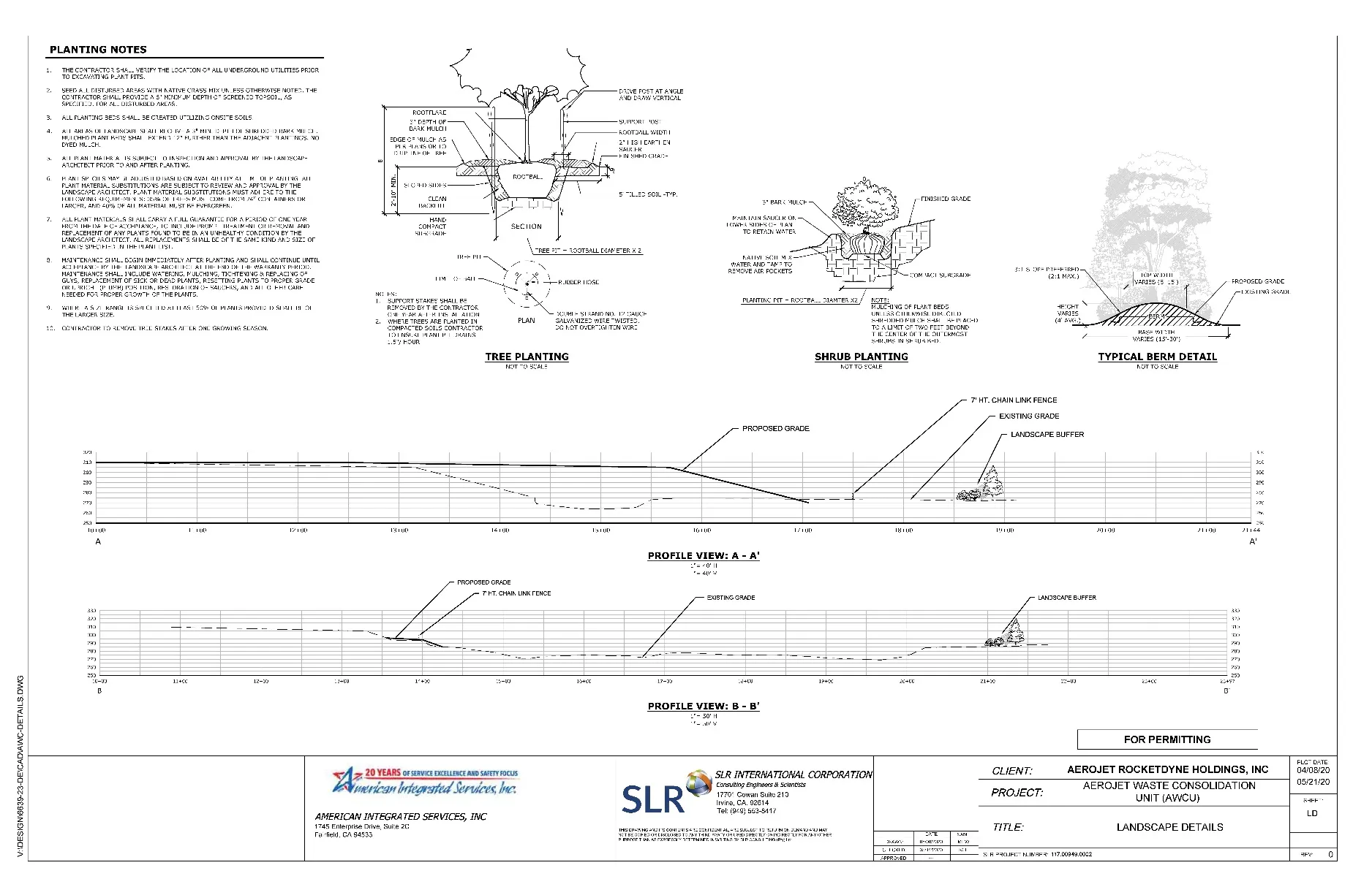
- Exhibit "317-F": AWCU Landscape Plan Details
508-314. Land Use Master Plan for “GLENBOROUGH at EASTON.”
Section titled “508-314. Land Use Master Plan for “GLENBOROUGH at EASTON.””- Glenborough is a master planned community as depicted on Exhibit 314-A and Exhibit B of this Ordinance. The Glenborough Land Use Master Plan designates eighteen single-family residential villages, three multi-family residential developments, two commercial mixed use sites, one commercial site, two office sites, three elementary school sites, and numerous park sites, in addition to a large open space area adjacent to or near Alder Creek. The land uses are described as follows:
- Commercial Mixed Use (CMU) Zone
Purpose and Intent
The Commercial Mixed Use (CMU) zone applies to two sites that front onto Prairie City Road and Easton Valley Parkway.
The Commercial Mixed Use Zone is designed to promote and protect the public health, safety, and general welfare. The Board of Supervisors in establishing this zone finds that this zone is consistent and compatible with the objectives, policies, general land uses, and programs specified in the Sacramento County General Plan; and is adopted for the following purposes:
- To permit flexibility of development on several sites in the project area.
- To provide well designed employment uses with adequate access for automobiles, pedestrians, and bicycles.
- To promote a mixture of uses where appropriate, with a balance of retail, commercial services, residential and office.
- To create compact, walkable mixed-use nodes
Permitted Uses
The uses permitted within the CMU designation are based on those uses allowed within the Limited Commercial (LC) Zone and the Business Professional (BP) Zone of the Sacramento County Zoning Code, with the flexibility to provide additional housing options. Residential uses are included within the CMU zone to encourage housing development close to jobs and retail services.
Acknowledging that market-driven uses may differ somewhat from the uses defined in the zoning code at any given moment, the list of permitted uses is provided by way of example, intended to describe the types of uses envisioned for the CMU Zone, rather than a comprehensive or exclusive list of uses.
The CMU Zone imposes additional restrictions than those provided in the LC and BP zones. The list of expressly prohibited uses appears at the end of this section, and is also provided by way of example.
Commercial Uses: Commercial Services and Retail
Commercial services and retail uses in the CMU Zone area should focus on providing commercial services for neighborhood residents and employees, and for regional visitors.
Examples of commercial services and retail uses include:
- Business Services (such as advertising businesses, copy shop, travel agency.)
- Personal Services (such as a dry cleaner or tailor.)
- Full-service restaurant, coffee shop, delicatessen, fast-food restaurants.
- Neighborhood serving food, drug, or liquor sales (such as a bakery, farmers’ market, convenience store/neighborhood market, supermarket, or drug store.)
- General merchandise (such as a book store, hardware store, florist, stationery store.)
- Gasoline service station.
Office Uses
Office Uses may be included within the CMU zone. Office uses shall have access to the nearby retail and residential uses. Office and commercial uses may be developed as mixed-use projects, and office uses may also be developed as stand-alone facilities.
Examples of office uses include, by way of example:
- Business or professional office.
- Insurance office.
- Medical or dental office.
- Bank/Financial Institution.
Residential Development
The targeted residential densities within the CMU zone shall be medium density residential (seven to twelve dwelling units per acre), although higher densities (twelve units per acre and above) are permitted. Residential prototypes that include town houses, freestanding apartments and apartments or condominiums over retail or office uses, and condominiums, are all permitted. Residential blocks are intended and designed to afford flexibility in lotting arrangements, allowing a mix of residential types and styles to occur within a single block.
Exceptions
The following uses that are currently allowed in the BP or the LC zones and are prohibited in the CMU zone include:
- Auto repair establishments, except as may be part of an auto service station.
- Motorcycle, sports cycles, trail bikes, jet skis, snowmobile, ultralight and moped sales rent, service, repair and dismantling.
- Automobile rental or lease agency.
- Truck sales, lease, rent, or repair.
- Utility trailer or truck, rent or storage as ancillary to permitted uses.
- Ambulance service.
- Psychiatric facility.
- Sanitarium.
- Social Rehabilitation Center.
- Bath House.
- Fortune teller, palmist, tarot-card reader.
- Tattoo Shop.
- Cold Storage, frozen food locker.
- Parking lot or garage as primary use.
- Mini-storage.
- Taxidermist.
- Towing Service.
- Grinding-Sharpening service.
- Lawn mower engine and garden power tools sales, service and repair.
- Tool Reconditioning.
- Arcade - electronic, mechanical, or video games.
- Card room.
- Building material and lumber sales
- Firewood sales.
- Garage equipment and tool sales.
- Pawn shop.
- Camper shell sales or service.
- Travel Trailer, Mobile Home, Motorhome, Camper - Sales, Rent, Storage.
- RV and boat storage.
- Recycling centers shall be permitted only with a conditional use permit.
- Driving School.
- Baggage transfer facility.
- Taxi cab storage facility.
- Bus Depot.
- Freight Depot.
- Village Commercial
The Village Commercial (VC) zone applies to a smaller commercial center, located in Village O at the intersection of Easton Valley Parkway and Glenborough Drive, which will serve nearby neighborhoods.
Permitted Uses
The permitted uses in the VC zone are those uses listed in the Sacramento County Zoning Code for the Limited Commercial (LC) zone.
Prohibited Uses
The following uses that are permitted in the LC zone are prohibited in the VC zone:
- All gasoline service stations.
- All auto service repair establishments.
- Motorcycle, sports cycles, trail bikes, jet skis, snowmobile, ultralight and moped sales rent, service, repair and dismantling. Automobile rental and service.
- Truck and utility trailer and truck sales, lease, rental, or service.
- Ambulance service.
- Cold storage, frozen food locker.
- Parking lot or garage as primary use.
- Mini-storage.
- Taxidermist.
- Towing service.
- Building material and lumber sales.
- Hardware stores.
- Pawn shop.
- Camper shell sales or service.
- Office Park Zone
Purpose and Intent.
The Office Park (OP) zone applies to two sites adjacent to Highway 50.
The Office Park Zone in these locations has been proposed to allow for a campus environment close to Highway 50 and near the light rail stations at Hazel Avenue and Iron Point Road. Uses within this zone include professional office, research and development, flex office and appropriate related uses.
The Office Park Zone is designed to promote and protect the public health, safety, and general welfare. The Board of Supervisors in establishing this zone finds that this zone is consistent and compatible with the objectives, policies, general land uses, and programs specified in the Sacramento County General Plan; and is adopted for the following purposes:
- To create job generating uses within close proximity to transit.
- To provide high quality, well designed employment uses that are compatible with the surrounding uses with adequate access for automobiles, pedestrians, and bicycles.
Permitted Uses
The permitted uses within the Office Park Zone are those listed in the Sacramento County Zoning Ordinance for the Business Professional (BP) Zone in addition to the following uses:
- Addressing and Mailing Services.
- Off-site signs.
- Blueprinting-Photostating Service.
- Computer Sales, rental and lease.
- Computer Service and training.
- Delivery Service.
- Mail or delivery service pick-up station.
- Remote teller, freestanding for pedestrian use.
- Delicatessen.
- Hotel.
- Restaurant, coffee shop, cafeteria.
- Physical fitness studio.
- Recreation facility, indoors.
- Stationery store.
- Bank, savings and loan, finance loan, credit union.
Exceptions
The following uses that are allowed in the BP zone are prohibited in the OP zone:
- Motor vehicle sales, rental, repair.
- Kennels, pet stores, and animal grooming.
- Warehousing and storage.
- Tool sales and repair.
- Convenience stores.
- Home improvement and furnishings.
- Retail sales, other than those listed in OP Permitted Uses, above.
- Gas stations.
- Adult entertainment establishments.
- Community Resource Area Zone
Purpose and Intent.
The Community Resource Area is located west of Prairie City Road adjacent to the Alder Creek open space corridor. The zone will provide a location for those community functions that are appropriate at the gateway to the major open space area and the community.
The Community Resource Area Zone is designed to promote and protect the public health, safety, and general welfare. The Board of Supervisors in establishing this zone finds that this zone is consistent and compatible with the objectives, policies, general land uses, and programs specified in the Sacramento County General Plan; and is adopted for the following purposes:
- To create recreation opportunities through vehicle parking and trail access.
- To provide educational opportunities at the gateway to the site’s most significant natural environment as part of the operations and management of the resource.
- To provide support services related to the public’s use of the Alder Creek corridor.
- To provide an information center related to Aerojet’s commitment to the community, resource information, community development opportunities and sales information for the site.
Permitted Uses
The permitted uses within the Community Resource Area Zone are as follows:
- Residential and Commercial Sales and information center.
- Café, restaurant, delicatessen or snack bar.
- Bicycle or sports equipment rental.
- Education, conservancy offices, exhibits building and associated parking.
- Vehicle and school bus parking related to open space and trail access.
- Plant nursery or propagation of materials to be used on the project site.
- Endangered species mitigation or conservation areas.
- All uses described and permitted as part of the Resource Conservation and management Plan for the Alder Creek regional park.
- Community Center, meeting rooms, conference facilities and outdoor and indoor event venues associated with the Community Center.
- Low Density Residential (LDR)
The low density residential designation is the largest use at Easton Villages A thru D, E1, F, G1, L, N, O1 and R1 are included in this category. These villages will have a density range from 1 to 7 dwelling units per acre. Sacramento County zoning designations of RD-3 to RD-7 would apply except as amended by the Development Standards Table.
- Medium Density Residential (MDR)
The medium density residential designation includes Villages E2, E3, E4, G2, M, P and R2. The residential density in these Villages will be between 7 and 12 dwelling units per acre. Sacramento County zoning designations of RD-7, RD-10 and RD-15 will apply except as amended by the Development Standards Table.
- High Density Residential (HDR)
The high density residential designation is located in Villages, I, O2 and Q. The residential densities in these Villages will be between 12 and 25 dwelling units per acre. Sacramento County zoning designations of RD- 15 to RD-30 will apply except as amended by the Development Standards Table.
- Elementary School
There are three elementary school sites on the property that will be combined with parks. The schools are located strategically near residential areas and recreational facilities and to serve the community with sidewalk and trail connections to the neighborhood and regional open space. One school will be located between Village M and N south of Easton Valley Parkway, another will be located in Village F, north of Easton Valley Parkway, and the third adjacent to Village Q. Each site will contain at least 10 acres for the school property and be located adjacent to a neighborhood park. The school sites are placed away from major roadways; however, access is clear and will not disrupt the traffic flow of the local streets.
- Major Roadways
There are four major roadways on the property including Easton Valley Parkway, Glenborough Drive, Birkmont Drive, and Kimball Place. The roadways include four to six travel lanes with the exception of Kimball Place, and will have standard curb and gutter sections with left-turn pockets. Center medians will vary in width, and will be landscaped with lawn, trees and shrubs that will enhance the character of the site. Street sections are highlighted in the Design Guidelines.
- Linear Parkways
The landscaped area behind the curb extending to the Villages and the private property boundaries will be a zone that varies in width. This area will contain a shared pedestrian/bicycle path and be attractively landscaped with trees, shrubs, lawn and ground covers. The path will meander in the zone and make connections to the neighborhoods at both Village entry drives and at portals at the end of cul-de-sac streets and other locations such as where greenways intersect. Parkways will be maintained through a benefit assessment district.
- Active Parks
The active parks at Glenborough will include larger neighborhood open spaces with sport fields to smaller Village identity ‘green’ spaces between roadways. Approximately 53 acres have been designated for active parks, as distinguished from the linear parkways, the larger regional park, and the passive parks, such as Alder Creek and native oak areas, respectively. Each park will be designed separately according to its function, with larger spaces that contain areas for active play and smaller parks perhaps serving only small children with tot lots. The intent is to create a diversity of spaces that meet the needs of all future residents.
- Regional Parks
Alder Creek and its main drainage corridor include approximately 270 acres, or 22% of the site area. The intent is to conserve and manage this unique resource while providing access in the form of trails and appropriate amenities such as seating picnic areas, viewing areas and education exhibits. A Resource and Conservation Management Plan (RCMP) will address the steps necessary to monitor, maintain and manage a healthy and vibrant open space system. Public utilities and public service facilities will be incorporated into this zone as necessary as a permitted use.
- Passive Parks
Passive Parks include all of greenways, minor drainage corridors and large areas of native oaks on the site. This network of open spaces forms the backbone of the north-south open space system, connecting the Villages to the Alder Creek corridor. The largest area within this designation is situated both north and south of the LDS Church property. Trails connecting the Villages to these open spaces will be provided as a passive recreational experience. Public utilities and public service facilities may be incorporated into these zones as necessary as a permitted use.
- Commercial Mixed Use (CMU) Zone
Purpose and Intent
- Development within the Glenborough LUMP area is subject to the rezone conditions for Easton Place and Glenborough in Exhibit E.
508-315. Land Use Master Plan for “EASTON PLACE.”
Section titled “508-315. Land Use Master Plan for “EASTON PLACE.””- Easton Place is a transit oriented, pedestrian scaled, regional high density mixed use center complemented by community serving commercial uses. This zone encompasses approximately 183 acres, as depicted on Exhibit 315-A and Exhibit B of this Ordinance. The Easton Place Land Use Master Plan designates three separate Districts within the plan area, including the Transit District, the Central District, and the Market District. Streets within Easton Place are laid out in a grid pattern connecting to the Hazel Avenue light rail station on the Folsom Line of Regional Transit. Urban parks are included within Easton Place. The Districts and the land uses permitted within each District are described as follows:
- Transit District Mixed Use Zone
Purpose and Intent.
The Transit District is generally located within ¼ mile of the Hazel Avenue light rail station. Regional Transit owns a seven acre parcel adjacent to the station for parking. This Transit District is bounded by the light rail corridor to the north, Atlanta Street to the south, Aerojet Road to the east, and Hazel Avenue to the west. Residential uses, complemented by office, hotel and retail services will be the primary uses in the Transit District. Residential units will be multi-family attached units including townhouses, condominiums and apartments in various configurations. Retail uses will be oriented to street frontages.
The Transit District Mixed Use Zone is designed to promote and protect the public health, safety and general welfare. The Board of Supervisors, in establishing this zone, finds that this zone is consistent and compatible with the objectives, policies, general land use, and programs specified in the Sacramento County General Plan, and is adopted for the following purposes:
-
To promote a mixture of uses appropriate for proximity to a light rail station
-
To create a compact, walkable mixed-use neighborhood
-
To permit flexibility with regard to the location of uses within the District
Permitted Uses
The uses permitted within the TDMU zone are based on those uses allowed within this Zoning Code for high density residential zones, including higher densities options not defined in this Code at the time of adoption of this SPA ordinance, as well as the Limited Commercial (LC) Zone and the Business and Professional Office (BP) Zone of this Code.
Acknowledging that market-driven uses may differ somewhat from the uses defined in the zoning code at any given time, the list of permitted uses is provided by way of example, intended to describe the types of uses envisioned for the TDMU Zone, rather than a comprehensive or exclusive list of uses.
The TDMU Zone imposes additional restrictions than those provided in the LC and BP zones, expressly prohibiting those uses which do not support a walkable, mixed-use environment. The list of expressly prohibited uses appears at the end of this section, and is also provided by way of example.
Commercial Uses: Commercial Services and Retail
Commercial services and retail uses in the TDMU Zone area should focus on providing commercial services for neighborhood residents and employees, as well as for those using the light rail transit station.
Examples of commercial services and retail uses include:
- Business Services (such as advertising businesses, copy shop, travel agency.)
- Personal Services (such as a dry cleaner or tailor.)
- Full-service restaurant, coffee shop, delicatessen, fast-food restaurants, coffee houses.
- Neighborhood serving food, drug, or liquor sales (such as a bakery, farmers’ market, convenience store/neighborhood market, supermarket, or drug store.)
- General merchandise (such as a book store, hardware store, florist, stationery store.)
Office Uses
Office Uses are encouraged within the TDMU zone to take advantage of the proximity of the light rail station and nearby retail and residential uses. Office and commercial uses may be developed as mixed-use projects, and office uses may also be developed as stand-alone facilities.
Examples of office uses include, by way of example and not of limitation:
- Business or professional office.
- Insurance office.
- Medical or dental office.
- Bank/Financial Institution.
Residential Development
Residential densities may range from twelve dwelling units per acre to 100 dwelling units per acre. Residential prototypes that include town houses, freestanding apartments, apartments over retail or office uses, and condominiums, are all permitted, to take advantage of the proximity of the light rail station, office and retail uses.
Exceptions
The following uses that are currently allowed in the BP or the LC zones and are expressly prohibited in the TDMU zone include:
- Auto repair establishments except as may be part of an auto service station.
- Motorcycle, sports cycles, trail bikes, jet skis, snowmobile, ultralight and moped sales, rent, service, repair and dismantling.
- Automobile rental or lease agency and service.
- Truck sale, lease, rent, or repair.
- Utility trailer or truck, rent or storage as ancillary to permitted uses.
- Ambulance service.
- Psychiatric Facility.
- Sanitarium.
- Social Rehabilitation Center.
- Bath House.
- Fortune teller, palmist, tarot-card reader.
- Massage Parlor.
- Tattoo Shop.
- Cold Storage, frozen food locker.
- Parking lot or garage as primary use.
- Mini-storage.
- Taxidermist.
- Towing Service.
- Grinding-Sharpening service
- Lawn mower engine and garden power tool sales, service, and repair.
- Tool Reconditioning.
- Arcade - electronic, mechanical, or video games.
- Card room.
- Building material and lumber sales.
- Firewood sales.
- Garage equipment and tool sales.
- Pawn shop.
- Camper shell sales or service.
- Travel Trailer, Mobilehome, Motorhome, Camper - Sales, Rent, Storage.
- RV and boat storage.
- Recycling centers shall be permitted only with a conditional use permit.
- Driving school.
- Baggage transfer facility.
- Taxi Cab Storage facility.
- Bus Depot.
- Freight Depot.
-
- Central District Mixed Use Zone
Purpose and Intent.
The Central District is located south of the Transit District. This District is bounded by Atlanta Street to the north, Easton Valley Parkway to the south, Aerojet Road to the east, and Hazel Avenue to the west. This District will include a central “Main Street” fronted by mixed-use buildings with retail, office and residential ground floor uses and either commercial or residential uses above. Residential uses are encouraged on the floors above commercial, retail, office and service uses on the ground floor in this District. Uses to the west and east of “Main Street” are proposed to contain mid- to high-rise buildings. A small civic core is proposed to accommodate local government offices, a neighborhood institution such as a public library, and other public or quasi-public uses as appropriate.
The Central District Mixed Use Zone is designed to promote and protect the public health, safety and general welfare. The Board of Supervisors, in establishing this zone, finds that this zone is consistent and compatible with the objectives, policies, general land use, and programs specified in the Sacramento County General Plan, and is adopted for the following purposes:
- To promote a mixture of uses appropriate for proximity to a light rail station, high density residential development to the north, and more intense commercial and retail development to the south.
- To create a compact, pedestrian-oriented mixed-use neighborhood.
- To permit flexibility with regard to the location of uses within the District.
- To provide well designed employment uses with adequate access for automobiles, pedestrians, and bicycles.
Permitted Uses
The uses permitted within the CDMU zone are based on those uses allowed within this Zoning Code for high density residential zones, including higher density options not defined in this Code at the time of adoption of this SPA ordinance, as well as the Limited Commercial (LC) Zone and the Business and Professional Office (BP) Zone of this Code.
Acknowledging that market-driven uses may differ somewhat from the uses defined in the zoning code at any given moment, the list of permitted uses is provided by way of example, intended to describe the types of uses envisioned for the CDMU Zone, rather than a comprehensive or exclusive list of uses.
The CDMU Zone imposes additional restrictions than those provided in the LC and BP zones, expressly prohibiting those uses which do not support a mixed-use environment. The list of expressly prohibited uses appears at the end of this section, and is also provided by way of example.
Commercial Uses: Commercial Services and Retail
Commercial services and retail uses in the CDMU Zone area should focus on providing commercial services for neighborhood residents and employees, as well as for those residents of the Transit District and Market District.
Examples of commercial services and retail uses include:
- Business Services (such as advertising businesses, copy shop, travel agency, insurance agencies, notary services.)
- Personal Services (such as a dry cleaner or tailor, barber shops, beauty parlors, day spas.)
- Full-service restaurant, coffee shop, delicatessen, fast-food restaurants.
- Neighborhood serving food, drug, or liquor sales (such as a bakery, coffee houses, farmers’ market, convenience store/neighborhood market, supermarket, or drug store.)
- General merchandise (such as a book store, hardware store, florist, stationery store.)
- Motion picture theatres.
- Performing arts venues.
- Museums.
Office Uses
Office Uses are encouraged within the CDMU zone to take advantage of the proximity of the light rail station and nearby retail and residential uses. Office and commercial uses may be developed as mixed-use projects, and office uses may also be developed as stand-alone facilities.
Examples of office uses include, by way of example and not of limitation:
- Business or professional office.
- Insurance office.
- Medical or dental office.
- Bank/Financial Institution.
Residential Development
Residential densities may range from twelve dwelling units per acre to 100 dwelling units per acre. Residential prototypes that include town houses, freestanding apartments, apartments over retail or office uses, and condominiums, are all permitted, to take advantage of the proximity of the light rail station, office and retail uses.
Exceptions
The following uses that are currently allowed in the BP or the LC zones and are expressly prohibited in the CDMU zone include:
- Auto repair establishments, except as may be part of an auto service station.
- Motorcycle, sports cycles, trail bikes, jet skis, snowmobile, ultralight and moped sales, rent, service repair and dismantling.
- Automobile rent and service.
- Truck sales, lease, rent, or service.
- Utility trailer or truck, rent or storage as ancillary to permitted uses.
- Ambulance Service.
- Psychiatric Facility.
- Sanitarium.
- Social Rehabilitation Center.
- Bath House.
- Fortune teller, palmist, tarot-card reader.
- Massage Parlor.
- Tattoo Shop.
- Cold Storage, frozen food locker.
- Parking lot or garage as primary use.
- Mini-storage.
- Taxidermist.
- Towing Service.
- Grinding-Sharpening service.
- Lawn mower engine and garden power tool sales, service, and repair.
- Tool Reconditioning.
- Arcade - electronic, mechanical, or video games.
- Card room.
- Building material and lumber sales.
- Firewood sales.
- Garage equipment and tool sales.
- Pawn shop.
- Camper shell sales or service.
- RV and boat storage.
- Travel Trailer, etc.- Sales, Rent, Storage.
- Recycling centers shall be permitted only with a conditional use permit.
- Travel Trailer, etc.- Repair or Service.
- Driving school.
- Baggage transfer facility.
- Bus Depot.
- Freight Depot.
- Taxi Cab Storage facility.
- Market District Mixed Use Zone
Purpose and Intent.
The Market District is bounded by Easton Valley Parkway to the north, the EPA carve-out boundary to the south, Aerojet Road to the east, and Hazel Avenue to the west. Of the three Districts comprising Easton Place, this District is the farthest away from the Hazel Avenue light rail station and, consequently, will contain lesser concentrations of residential uses and contain more neighborhood and region-serving retail and general commercial uses.
The Market District Mixed Use Zone is designed to promote and protect the public health, safety and general welfare. The Board of Supervisors, in establishing this zone, finds that this zone is consistent and compatible with the objectives, policies, general land use, and programs specified in the Sacramento County General Plan, and is adopted for the following purposes:
-
To promote a mixture of commercial and residential uses appropriate for proximity to residential, office and civic development to the north, and the full range of residential uses, including affordable housing, at Glenborough at Easton to the east.
-
To permit flexibility with regard to the location of uses within the District.
-
To provide well designed market commercial uses with adequate access for automobiles, pedestrians, and bicycles.
Permitted Uses
The uses permitted within the MDMU zone are based on those uses allowed within the medium and high density residential zones of this Code, the Limited Commercial (LC) Zone, the Shopping Center (SC) Zone, and the General Commercial (GC) Zone of this Code.
Acknowledging that market-driven uses may differ somewhat from the uses defined in the zoning code at any given moment, the list of permitted uses is provided by way of example, intended to describe the types of uses envisioned for the MDMU Zone, rather than a comprehensive or exclusive list of uses.
The MDMU Zone imposes additional restrictions than those provided in the SC, LC and GC zones, expressly prohibiting those uses which do not support a walkable, mixed-use environment. The list of expressly prohibited uses appears at the end of this section, and is also provided by way of example.
Commercial Uses: Commercial Services and Retail
Commercial services and retail uses in the MDMU Zone area should focus on providing commercial services for residents and employees in Easton Place and Glenborough at Easton.
Examples of commercial services and retail uses include:
- Business Services (such as advertising businesses, copy shop, travel agency, banking institution, insurance agency, notary services.)
- Personal Services (such as a dry cleaner or tailor, health club.)
- Full-service restaurant, coffee shop, delicatessen, fast-food restaurants.
- Neighborhood serving food, drug, or liquor sales (such as a bakery, farmers’ market, convenience store/neighborhood market, supermarket, or drug store.)
- General merchandise (such as a clothing, shoes, housewares, and linens, athletic apparel and equipment, book store, hardware store, florist, stationery store.)
- Region serving food, drug, or liquor sales.
Office Uses
Office uses are permitted within the MDMU zone provide such uses are consistent with the commercial uses in the same proximate area. Office and commercial uses may be developed as mixed-use projects, and office uses may also be developed as stand-alone facilities.
Examples of office uses include, by way of example and not of limitation:
- Business or professional office.
- Insurance office.
- Medical or dental office.
- Bank/Financial Institution.
Residential Development
Residential densities within the MDMU zone shall be a minimum of seven (7) dwelling units per acre, although higher densities are permitted. Residential prototypes that include town houses, freestanding apartments, apartments over retail or office uses, and condominiums, are all permitted, to take advantage of the proximity of the office and commercial retail uses, as well as parks and schools.
Exceptions
The following uses that are currently allowed in the SC, LC or GC zones and are expressly prohibited in the MDMU zone include:
- Auto repair establishments, except as may be part of an auto service station.
- Motorcycle, jet skis, snowmobile, and moped sales and service.
- Truck sales, lease, rent, or service.
- Psychiatric Facility.
- Sanitarium.
- Social Rehabilitation Center.
- Fortune teller, palmist, tarot-card reader.
- Massage Parlor.
- Tattoo Shop.
- Cold Storage, frozen food locker.
- Taxidermist.
- Towing Service.
- Towed Vehicle Storage.
- Arcade - electronic, mechanical, or video games.
- Card room.
- Carnival.
- Circus.
- Pawn shop.
- Camper shell sales or service.
- Motorcycle, etc., Sales, Rent, Service, Repair and Dismantling.
- RV and boat storage.
- Recycling centers shall be permitted only with a conditional use permit.
- Driving school.
- Baggage Transfer Facility.
- Freight Depot.
- Taxi Cab Service and Storage Facility.
-
- Transit District Mixed Use Zone
- Development within the Easton Place LUMP area is subject to the rezone conditions for Easton Place and Glenborough in Exhibit E.
508-316 AEROJET WASTE CONSOLIDATION UNIT (Parent APN 072-0100-020)
Section titled “508-316 AEROJET WASTE CONSOLIDATION UNIT (Parent APN 072-0100-020)”- The Aerojet Waste Consolidation Unit (AWCU) is a 1,000,000 cubic yard (CY) Class II Landfill within the eastern portion of the 250-acre parcel as depicted on Exhibit 317-A of this Ordinance. The AWCU is located on top of the existing pre-regulation 100-acre White Rock North Dump with the surrounding area and western portion containing undeveloped land with various biological and aquatic resources. The AWCU consists of 500,000 CY of Transfer Material excavated from the Aerojet Solid Waste Landfill and 500,000 CY from other areas within the AWCU Service Area. Transfer Material includes waste soil that exceeds contamination screening levels (Class II waste) and inert construction debris, which would be transported via private roads located within the AWCU Service Area as depicted on Exhibit 317-B. The AWCU shall be designed and screened in substantial compliance with Exhibits 317-C, 317-D, 317-E, and 317-F. If the AWCU is constructed, the AWCU and the remainder of the existing pre-regulation 100-acre White Rock North Dump (following any consolidation to reduce footprint) is to be capped and closed in accordance with Title 27 requirements once the AWCU is completely filled to the maximum 1,000,000 CY capacity or by December 31, 2035, whichever occurs first.
- Absent an amendment to the Aerojet Special Planning Area, no new or additional development within the boundaries of the parent parcel (APN 072-0100-020), expansion or enlargement of the AWCU or WRND, or intensification of use shall occur.
- This action does not relieve the applicant of the obligation to comply with all ordinances, statutes, regulations and procedures. Any required subsequent procedural actions shall take place within 36 months of the date on which the permit became effective or this action shall automatically be null and void.
- Zoning shall be in accordance with Exhibit “X”.
- The applicant shall provide disclosure to prospective purchasers of property in the project area of potential aircraft overflights and noise exposure associated with the project’s location below the arrival path of aircraft approaching Mather Airport. The disclosure will be provided at the time of the initial sale of homes. (Mitigation Measure LU-6a)
- The applicant shall ensure that a permanent Grant of Avigation and Noise Easement is granted to Sacramento County for property in the project area. The grant will be attached to the property and will remain in title with subsequent property transfers. Execution of the grant will occur prior to approval of the subdivision maps. (Mitigation Measure LU-6b)
- The applicant shall limit construction to daylight hours. If nighttime lighting or construction is necessary, the applicant shall ensure that unshielded lights, reflectors, or spotlights are not located and directed to shine toward or be directly visible from adjacent properties or streets. To the extent possible, the applicant shall minimize the use of nighttime construction lighting within 500 feet of existing residences, including the apartments and mobile homes on Folsom Boulevard. This measure will be identified on grading plans and in construction contracts. (Mitigation Measure AE-1)
- The applicant shall revise the LUMPs to include design guidelines that comply with Sacramento County General Plan Land Use Element policies LU-22 and LU-23. These policies require exterior building materials on nonresidential structures to be composed of a minimum of 50 percent low-reflectance, non-polished finishes, and encourage bare metallic surfaces such as pipes, flashing, vents, and light standards on new construction to be painted so as to minimize reflectance. The revised LUMPs will be approved by the County as part of final project approval. (Mitigation Measure AE-5)
-
Prior to each phase of development and issuance of grading permits, the applicant shall be required to obtain coverage under the General Permit for Discharges of Stormwater Associated with Construction Activity from the Central Valley RWQCB. As part of the permit application, the applicant shall prepare a SWPPP to identify the sources of sediment and other pollutants on site and to ensure the reduction of such pollutants in stormwater discharged from the site. The SWPPP will include an Erosion and Sedimentation Control Plan and provide descriptions of Best Management Practices (BMPs) selected to control erosion, sediment discharge, and other pollutant sources during construction. The SWPPP will be approved by the RWQCB prior to any ground-disturbing activities, and appropriate BMPs will be implemented throughout the duration of construction activities.
BMPs identified in the SWPPP and Erosion and Sedimentation Control Plan will be implemented during each phase of construction. Table HWQ-2 identifies typical BMPs from the Stormwater Best Management Practice Handbook for Construction (CSQA 2004a) that may be used. (Mitigation Measure HWQ-2a)
-
The applicant shall prepare a Fluvial Geomorphic and Stormwater Quality Assessment for the Alder Creek corridor within and immediately downstream of the project area. The study will evaluate the Alder Creek floodplain and the project’s proposed water quality basins to determine the potential for increased erosion resulting from the project’s increased runoff. Parameters for the study will be discussed and determined in consultation with the Sacramento County Water Resources Department. The study will be completed prior to any grading activities in the project area.
If the study concludes that substantial erosion is anticipated from project runoff, recommendations to reduce or minimize erosion will be identified and will be implemented as part of each phase of construction or incorporated into project design, as appropriate and in consultation with the County. Erosion control measures may include construction of detention basins, use of standard construction and urban BMPs (see Mitigation Measures HWQ-2a and HWQ-4a), or diversion of runoff to another location along Alder Creek to reduce the impact of increased runoff in more sensitive areas. Specific measures will be approved prior to issuance of grading permits (for facilities that may require grading) or prior to issuance of building permits (for facilities or measures incorporated into project design). (Mitigation Measure HWQ-2b)
-
Prior to each phase of development and the issuance of improvement plans approval, the applicant shall be required to prepare a Post Construction Stormwater quality plan (PCSQP), in compliance with the County’s Stormwater Quality Standards for Development Projects. The plan shall demonstrate the design of the proposed treatment and Low Impact Development (LID) measures to reduce pollutants in urban runoff, per the latest edition of the Stormwater Quality Design Manual. The PCSQP shall be prepared by a registered civil engineer or a registered professional hydrologist in coordination with and Sacramento County Department of Water Resources (DWR). The plan will be reviewed and approved by the County’s DWR prior to any ground-disturbing activities. Treatment and LID measures described in the plan will be incorporated into project design and implemented as part of each phase of development. In addition, long term maintenance of the proposed treatment and applicable LID measures shall be ensured by executing maintenance covenants with the County’s DWR before the approval of the plan.
A variety of stormwater BMPs are available for managing urban runoff. Stormwater BMPs are most effective when implemented as part of a comprehensive stormwater management program that includes proper selection, design, construction, inspection, and maintenance measures. Stormwater BMPs can be grouped into two broad categories: structural and non- structural. Structural BMPs are used to treat the stormwater at either the point of generation or the point of discharge to the stormwater sewer system or to receiving waters. Non- structural BMPs include a range of pollution prevention, education, institutional, management, and development practices designed to limit the conversion of rainfall to runoff and to prevent pollutants from entering runoff at the source of runoff generation.
Table HWQ-3 provides a summary of potential structural and nonstructural stormwater BMPs that may be used (EPA 1999; CSQA 2004b; Sacramento Stormwater Quality Partnership 2007).
LID is a stormwater management strategy designed to maintain or restore the natural hydrologic functions of an area. This strategy incorporates natural and built features to control stormwater runoff by reducing the runoff rate, filtering pollutants, and facilitating groundwater infiltration. LID measures are designed to improve the quality of surface waters and stabilize flow rates. Typical measures may include preserving open space, minimizing land disturbance, protecting natural systems and processes, using traditional site infrastructure, incorporating natural site elements as design features, and micromanaging stormwater at its source. The project incorporates many of these measures, through preservation of the Alder Creek corridor, and the applicant shall incorporate additional, feasible measures into the project’s design. (Mitigation Measure HWQ-4a)
-
The applicant shall prepare an on-site construction mitigation plan, which will be approved by the County and SMAQMD prior to issuance of grading permits, demonstrating that the heavy-duty (>50 horsepower) off-road vehicles to be used during construction, including owned, leased and subcontractor vehicles, will achieve a project-wide fleet-average 20 percent NOx reduction and 45 percent particulate reduction compared with the most recent ARB fleet average at time of construction, utilizing equipment reasonably available in the commercial marketplace. Acceptable options for reducing emissions may include use of late-model engines, low-emission diesel products, alternative fuels, engine retrofit technology, after-treatment products, and other options as they become available. Additional measures to be implemented include minimizing idling time to no more than 10 minutes, using low-sulfur fuel for stationary equipment, using low-emission on-site stationary equipment, and ensuring all equipment is properly tuned and maintained.
During each phase of construction, a comprehensive inventory of all off-road construction equipment equal to or greater than 50 horsepower that will be used an aggregate of 40 or more hours will be submitted to the County and SMAQMD. The inventory should include the horsepower rating, engine production year, and projected hours of use or fuel throughput for each piece of equipment. The inventory should be updated and submitted monthly throughout the duration of the project, except that an inventory should not be required for any 30-day period in which no construction activity occurs. At least 48 hours prior to the use of subject heavy-duty off-road equipment, the anticipated construction timeline, including start date and name and phone number of the project manager and on-site foreman, will be provided to SMAQMD.
This measure is part of the project’s Proposed Approach to Reduce Particulate Matter Emissions (Appendix I). This approach will be approved by the County and SMAQMD prior to issuance of grading permits. (Mitigation Measure AQ-1a)
-
The applicant shall ensure that emissions from all off-road diesel-powered equipment used in the project area do not exceed 40 percent opacity for more than three minutes in any one hour. Any equipment found to exceed 40 percent opacity (or Ringelmann 2.0) should be repaired immediately, and the County and SMAQMD should be notified within 48 hours of identification of non-compliant equipment. A visual survey of all in-operation equipment should be made at least weekly, and a monthly summary of the visual survey results should be submitted throughout the duration of the project, except that the monthly summary will not be required for any 30-day period in which no construction activity occurs. The monthly summary should include the quantity and type of vehicles surveyed as well as the dates of each survey. The SMAQMD and other officials may conduct periodic site inspections to determine compliance.
This measure is part of the project’s Proposed Approach to Reduce Particulate Matter Emissions (Appendix I). This approach will be approved by the County and SMAQMD prior to issuance of grading permits. (Mitigation Measure AQ-1b)
-
The applicant shall pay a mitigation fee prior to each phase of construction (before any earth-disturbing activities) in accordance with the SMAQMD Construction Air Quality Mitigation Plan Protocol (SMAQMD 2007c). Because NOx emissions would not be reduced to acceptable levels with implementation of the previous two mitigation measures, an off-site construction mitigation fee is required. The current (as of November 2007) off- site mitigation fee is $14,300 per ton of emissions. Assuming a 20 percent reduction in NOx emissions with implementation of Mitigation Measures AQ-1a and AQ-1b, the total off-site mitigation fee would be approximately $4.1 million, depending on specific acreages of disturbance for each phase. The calculation of the off-site mitigation fee is included in Appendix I. The County will calculate the final mitigation fee using the most recent SMAQMD off-site construction mitigation fee calculation prior to the fee being collected for each phase of construction. (Mitigation Measure AQ-1c)
-
The applicant shall ensure implementation of dust control measures and a particulate matter monitoring program during each phase of construction. Dust control measures identified in the project’s Proposed Approach to Reduce Particulate Matter Emissions (Appendix I) include:
-
Minimize on-site construction vehicle speeds on unpaved surfaces. Speed limits must be posted.
-
Suspend grading operations when wind is sufficient to generate visible dust clouds.
-
Pave, water, use gravel, cover, or spray a dust-control agent on all haul roads.
-
No open burning of vegetation during project construction. Vegetative material should be chipped or delivered to waste to energy facilities.
-
Reestablish vegetation as soon as possible after construction and maintain vegetation.
-
Clean earth-moving construction equipment with water once daily and clean all haul trucks leaving the site.
-
Exposed earth surfaces, graded areas, storage piles, and haul roads should be watered and kept moist at all times. (Mitigation Measure AQ-2)
-
-
The applicant shall implement measures identified in the project’s AQMP (Appendix I) to reduce vehicle emissions associated with project implementation. The AQMP was developed in accordance with the SMAQMD Recommended Guidance for Land Use Emission Reductions, 2007 Update (SMAQMD 2007b) and describes how the project, as confirmed by AQMD staff, will reduce ROG and NOx emissions by 16.78 percent, exceeding SMAQMD’s standard emission reduction goal. Emission reduction measures contained in the draft AQMP include (note that many of the measures in the AQMP are already included in the project description):
-
Short- and long-term bicycle parking facilities with “end of trip” services (i.e., lockers, showers, and changing areas) in all non-residential areas
-
Long-term bicycle parking at apartment complexes or condominiums without garages
-
Internal bicycle trail network, including bike lanes along roads and trails in open space areas
-
Internal pedestrian access network, including sidewalks, trails, and access that would not conflict with automobile access
-
Transit stops within the project area
-
Traffic calming measures to promote pedestrian and bicycle trips
-
Adequate parking facilities that connect transit facilities to adjacent uses
-
High density residential, office, and mixed use close to transit opportunities
-
No wood-burning fireplaces or stoves in residential buildings
-
Energy Star-certified roofing materials on all office, commercial, and mixed use buildings
-
Service and refueling facilities for alternative fuel vehicles (Mitigation Measure AQ- 4a)
-
-
The applicant will implement operational mitigation measures identified in the applicant’s GHG reduction plan (Section 18.4). These measures would reduce project GHG emissions by about 57 percent. The Easton Place and Glenborough at Easton LUMPs will be revised, as necessary, to incorporate additional feasible operational measures identified in the Attorney General’s list. The revised LUMPs will be approved by the County as part of final project approval. (Mitigation Measure AQ-4b)
-
The applicant shall implement applicable measures to reduce construction-related noise.
Measures would include, but are not limited to, the following: maintaining all manufacturer- installed engine mufflers and enclosures on powered construction equipment; fitting impact tools with adequate mufflers and shrouding; locating construction staging areas and fixed powered construction equipment as far as possible from sensitive receivers; providing shielding or enclosures for fixed equipment to reduce noise exposures to sensitive receivers; and limiting construction to daytime hours (6 a.m. to 8 p.m. weekdays and 7 a.m. to 8 p.m. on weekends) and weekdays. These measures will be identified on grading plans and approved by the County prior to issuance of grading permits. (Mitigation Measure NO-1) -
For properties in the project area significantly affected by transportation noise, the applicant shall either construct sound walls, ranging in height from 6 to 7.5 feet depending on distance to roads, or identify alternate measures through an acoustical study to achieve acceptable interior and exterior noise levels in accordance with Sacramento County Noise Element policies (see Plate NO-2). Acceptable exterior noise levels include 60 dB Ldn/CNEL or the performance standards of General Plan Noise Element Table II-1 for residences; 70 dB Ldn/CNEL after inclusion of protective noise reduction measures for schools and libraries; and 65 dB Ldn/CNEL for office, business, commercial, and professional land uses. Acceptable interior noise levels include 45 dB Ldn/CNEL for residences, 35 to 45 dBA Leq for classrooms, 40 to 45 dBA Leq for small offices and libraries, 45 to 50 dBA Leq for stores, and 45 to 55 dBA Leq for restaurants. Note that the affected units identified below are close enough to the roads that designs or setbacks would not be adequate to reduce traffic noise impacts.
Sound walls should be constructed at the following locations along Easton Valley Parkway, based on tentative subdivision map (TSM) units within 85 to 130 feet from the center line:
-
TSM Unit 1, Lot 1 (6 feet tall)
-
TSM Unit 2, Lots 37-40, 42, 43, 45-51 (7.5 feet tall)
-
TSM Unit 3, Lots 1-9, 227-240 (7.5 feet tall)
-
TSM Unit 5, Lots 1-12, 153, 154, 160-162, 168, 169, 178-182 (7.5 feet tall)
-
TSM Unit 6, Lots 1, 10, 11, 30, 39, 40, 51, 52, 63, 64, 89 (6 feet tall)
-
TSM Unit 6, Lots 95-105 (7.5 feet tall)
-
TSM Unit 7, Lots 1-8 (7.5 feet tall)
-
TSM Unit 8, Lots 1-6, 8, 89-90, 93-98 (7.5 feet tall)
-
TSM Unit 8, Lot 9 (7 feet tall)
-
TSM Unit 8, Lot 10 (6.5 feet tall)
-
TSM Unit 9, Lots 14, 15-28, 212-222, 286-295, 398-406 (7.5 feet tall)
-
TSM Unit 10, Lots 1-4, 168-175 (7.5 feet tall)
Sound walls should be constructed at the following locations along Glenborough Drive, based on TSM units within 75 to 80 feet from the centerline:
-
TSM Unit 3, Lots 191-196, 207-209, 215, 216, 219-226 (6 feet tall)
-
TSM Unit 5, Lots 13-36 (6 feet tall)
-
TSM Unit 9, Lots 29-44, 147, 148, 150-152, 153 (6 feet tall)
-
TSM Unit 10, Lots 115-121 (6 feet tall)
Sound walls should be constructed at the following locations near U.S. 50, based on TSM units within 800 to 1,450 feet from the centerline:
- TSM Unit 4, Lots 1-5, 32-38 (6 feet tall)
- TSM Unit 6, Lot 97 (7 feet tall)
- TSM Unit 6, Lots 225, 248 (6 feet tall)
As an alternate to constructing sound walls at the above lots, and for high density residential land uses, schools, and other sensitive land uses that would be significantly affected by transportation noise and are not shown on the TSMs, the applicant shall obtain an acoustical professional to conduct an acoustical investigation and to recommend measures necessary to maintain acceptable exterior and, when applicable, interior noise levels at the time of the development proposal. Acceptable noise levels are provided above.
The amount of noise reduction required to ensure compliance with County standards would vary depending on site-specific environmental factors, including distance to the U.S. 50, Folsom Boulevard, Hazel Avenue, Easton Valley Parkway, Glenborough Drive, and Prairie City Road, and noise attenuation provided by intervening buildings, structures, and vegetation. The acoustical study will determine the specific level of noise reduction required to meet the County’s standards.
The specific measures required for any given residence, school, or other sensitive receptor would depend on various factors, including exterior noise exposure, building height and orientation, and the details of building elevations, floor plans and façade design, including the relative amount of window exposure to traffic noise. Measures to be employed may include, but are not limited to, sound walls, construction of stucco walls for the exterior, attic vents that are acoustically baffled, buildings with adequate and appropriately designed mechanical ventilation systems, roof insulation, and acoustically rated windows and doors. Specific designs for buildings will be submitted to Sacramento County for approval prior to issuance of building permits to ensure compliance with noise standards. (Mitigation Measure N0-3)
-
-
For proposed residences significantly affected by light rail noise in Easton Place, the applicant shall obtain an acoustical professional to conduct an acoustical investigation and to recommend measures necessary to achieve acceptable interior and exterior noise levels in accordance with Sacramento County Noise Element policies.
Acceptable exterior noise levels would be 60 dB Ldn/CNEL or the performance standards of General Plan Noise Element Table II-1, and acceptable interior noise levels would be 45 dB Ldn/CNEL.The amount of noise reduction required to ensure compliance with County standards would vary depending on site-specific environmental factors, including distance to the light rail line and noise attenuation provided by intervening buildings, structures, and vegetation.
The acoustical study will determine the specific level of noise reduction required to meet the County’s standards.
The specific measures required for any given residence would depend on various factors, including exterior noise exposure, building height and orientation, and the details of building elevations, floor plans and façade design, including the relative amount of window exposure to traffic noise. Measures to be employed may include, but are not limited to, construction of stucco walls for the exterior, attic vents that are acoustically baffled, buildings with adequate and appropriately designed mechanical ventilation systems, roof insulation, and acoustically rated windows and doors. Specific designs for buildings will be submitted to Sacramento County for approval prior to issuance of building permits to ensure compliance with noise standards. (Mitigation Measure NO-4)
-
For proposed land uses significantly affected by non-transportation noise, the applicant shall obtain an acoustical professional to conduct an acoustical investigation and to recommend measures necessary to achieve acceptable interior and exterior noise levels in accordance with Sacramento County Noise Element policies. The specific measures required for any given residence or noise-sensitive use would depend on various factors, including exterior noise exposure, building orientation, and the details of building elevations, floor plans, and façade design, including the relative amount of window exposure to the noise source. Measures to be employed may include, but are not limited to, appropriate setbacks for buildings near substantial non-transportation noise sources, construction of stucco walls for the exterior, attic vents that are acoustically baffled, buildings with adequate and appropriately designed mechanical ventilation systems, roof insulation, and acoustically rated windows and doors. Specific designs for buildings and setbacks will be submitted to Sacramento County for approval prior to issuance of building permits to ensure compliance with noise standards.
Acceptable exterior noise levels include 60 dB Ldn/CNEL or the performance standards of General Plan Noise Element Table II-1 for residences, 70 dB Ldn/CNEL after inclusion of protective noise reduction measures for schools and libraries, and 65 dB Ldn/CNEL for office, business, commercial, and professional land uses. Acceptable interior noise levels include 45 dB Ldn/CNEL for residences, 35 to 45 dBA Leq for classrooms, 40 to 45 dBA Leq for small offices and libraries, 45 to 50 dBA Leq for stores, and 45 to 55 dBA Leq for restaurants. The amount of noise reduction required to ensure compliance with County standards would vary depending on site-specific environmental factors, including distance to the noise source and noise attenuation provided by intervening topography buildings, structures, and vegetation. The acoustical study will determine the specific level of noise reduction required to meet the County’s standards. (Mitigation Measure NO-5a)
-
Project applicants for future commercial development in the project area shall obtain an acoustical professional to conduct an acoustical investigation and to recommend measures necessary to maintain the exterior and, when applicable, interior noise levels at residential and noise-sensitive land uses existing at the time of the commercial development proposal. The acoustical investigation shall include, but not be limited to, potential noise conflicts due to operation of the following items:
- Mechanical building equipment, including HVAC systems
- Loading docks and associated truck routes
- Refuse pick up locations
- Refuse or recycling compactor units
Specific designs for proposed facilities will be submitted to Sacramento County for approval prior to issuance of building permits to ensure compliance with noise standards. (Mitigation Measure NO-5b)
-
The applicant shall revise the RCMP consistent with mitigation measures provided in this EIR and implement natural resources protection measures and natural resource programs identified in the RCMP (Appendix F). Specific EIR mitigation measures that will need to be incorporated into a revised RCMP include Mitigation Measure BR-3, BR-5, BR-6, BR-8, BR-9, BR-12, BR-14a, BR-14b, and BR-15. The RCMP shall be revised to reflect these measures and any additional or updated measures identified in the biological permits from the USACE, USFWS, or others prior to approval of improvements plans. All biological resource mitigation measures required for individual species or resources described in this EIR depend to one degree or another upon the successful implementation of the RCMP programs. These measures include, but are not limited to, designing project facilities to avoid sensitive biological resources; preserving wetlands, oak trees, and riparian habitat within the EOSP; protecting off-site habitat in conservation easements; and educating the public about the importance of natural resources protection. The applicant shall implement all applicable measures identified in the RCMP during construction and following development of the project area. The entity responsible for managing the CRA and Alder Creek corridor (Sacramento County Department of Regional Parks, Glenborough Community Association, or a third-party conservancy or similar organization) would be responsible for ensuring protection of preserved natural resources within those areas.
Management of the EOSP would be guided by the project’s RCMP (Appendix F and its appendices contained in Appendix G); the applicant’s intent is that this document be a living document that incorporates adaptive management strategies to effectively manage the preserved and restored habitats in the EOSP. The RCMP may evolve over time as the adaptive management strategies provide new information. (Mitigation Measure BR-1)
-
The applicant shall avoid riparian woodlands to the extent feasible during construction activities in the project area. For riparian woodlands (defined as valley foothill riparian, Fremont cottonwood woodlands, and willow scrub based on USFWS 1997) that cannot be avoided, the applicant shall calculate the acreage of woodlands lost and compensate for the loss by preserving and restoring similar riparian woodlands at an off-site conservation easement. This easement may be the same off-site easement used to preserve oak tree canopy (Mitigation Measure BR-4), as long as the easement contains the same types of riparian woodlands as the affected woodlands in the project area (e.g., valley foothill riparian or Fremont cottonwood woodland). The off-site easement must occur outside of a designated natural preserve and shall be under the ownership of a public agency or appropriate entity approved by the County (Policy CO-72). To ensure no net loss of riparian woodlands, the easement shall also be used to restore riparian woodlands to replace the amount of riparian woodlands affected in the project area. A restoration plan shall be prepared to describe the specific goals and methodology to restore riparian woodlands. The plan will contain the same types of information identified in Mitigation Measure BR-4 for the oak tree mitigation plan. This plan will be approved by Sacramento County prior to approval of grading plans or improvement plans. This mitigation measure will be incorporated into the Final RCMP. (Mitigation Measure BR-3)
-
The applicant shall be required to implement measures relating to oak tree canopy restoration and preservation as described in the RCMP and implement the Native Oak Tree Mitigation Plan (ECORP 2007e), which is included as Appendix F to the RCMP and included in Appendix G of this EIR. Specifically, these measures include on-site restoration of approximately 47 acres of oak trees within the EOSP and off-site preservation of approximately 52 acres of oak tree canopy within a conservation easement of at least 112 acres in eastern Sacramento County (to be approved by the County).
On-site Restoration. Approximately 47 acres of disturbed land and slopes were estimated to be available for on-site restoration within the EOSP. The restoration sites will be specifically evaluated during construction phases to assess soil characteristics, site conditions, and other factors to determine if oak trees could be successfully planted. If any sites are determined infeasible for on-site restoration of oak trees, additional off-site conservation easements would be secured in coordination with Sacramento County. Suitability criteria for each restoration site include the following:
- Appropriate soil types and water table
- Easily accessible
- Size of site is sufficient for planting, irrigating, maintenance, and monitoring
- Able to be irrigated, hand watered, or supplied with Dri-Water
- Safe for planting, maintenance, and monitoring crews
- Minimal site preparation needed
- No conflicts with more appropriate uses
Valley oak, interior live oak, and blue oak woodland will be planted at each restoration site, as appropriate. A detailed planting plan that includes planting and irrigation plans, monitoring plans, success criteria, phasing of restoration activities, and other restoration details will be submitted to the County prior to grading activities and will be approved prior to issuance of grading permits. On-site or off-site plantings to achieve an equivalent oak tree canopy shall consist of oak trees planted no closer than 10 feet minimum on center spacing and 40 feet maximum on center spacing to achieve an average spacing of 25 feet. Plan details may include the following:
- Water mitigation plantings for three to five years using an irrigation system, hand watering during dry season, or using Dri-Water irrigation supplement.
- Protect plantings with shelter or fencing to minimize foraging by wildlife. Beaver- resistant caging could be used near Alder Creek; prefabricated tubular shelter could be used away from the creek; tall fencing (to prevent deer from jumping over) could be used on larger tracts.
- Monitor over a seven-year period during years 1, 2, 3, 5, and 7. Successful plantings would include trees surviving in at least good condition. If the overall success rate falls below 100 percent, additional plantings will be necessary to replace dead or poor-health trees. Other measures may also be implemented to improve the success rate, such as soil augmentation or irrigation system improvements.
Off-Site Conservation. Because additional land is not available on-site for restoration plantings, the remaining affected oak tree canopy will be offset through establishment of a conservation easement in eastern Sacramento County, preferably within 5 miles of the project area. The easement will contain a minimum of 51.99 acres of oak tree canopy and at least 112.3 total acres of land to allow for regeneration. The total land acreage includes the affected area of oak tree canopy plus a 30-foot buffer around the canopy (in this case, 51.99 acres of affected canopy was buffered at 30 feet, totaling 112.3 acres of land). The easement will be coordinated with the County and willing participants in the project vicinity and will be held and managed by a conservation-oriented entity approved by the County. The land will be protected through fee title or easement in perpetuity.
- The off-site preservation area must satisfy the following conditions, consistent with the Conservation Element of the General Plan (Policy CO-136):
- Is of equal or greater in area to the total area that is included within a radius of 30 feet of the dripline of all trees to be removed (at least 112.3 acres of preservation area required);
- Is adjacent to protected stream corridor or other preserved natural areas;
- Supports a significant number of native broadleaf trees; and
- Offers good potential for continued regeneration of an integrated woodland community. (Mitigation Measure BR-4)
-
During all construction activities, the applicant shall ensure the preservation and protection of all native oak trees that are 6 inches diameter at breast height (dbh) or larger in the project area, all portions of adjacent off-site native oak trees that are 6 inches dbh or larger which have driplines that extend into the project area, and all off-site native oak trees that are 6 inches dbh or larger which may be affected by utility installation and/or improvements associated with this project. As necessary, pre-construction surveys by a Certified Arborist to identify and tag oak trees within proposed construction areas within the EOSP, along the security fence, and throughout the project area as appropriate should occur. Driplines of tagged oak trees should be assessed to determine potential impacts and measures to implement to avoid adverse effects on the trees. This mitigation measure will be incorporated into the Final RCMP.
The following measures shall be implemented during project construction activities; these measures will be identified on grading plans and will be approved by the County prior to issuance of grading permits:
- A circle with a radius measurement from the trunk of the tree to the tip of its longest limb shall constitute the dripline protection area of each tree. Limbs must not be cut back in order to change the dripline. The area beneath the dripline is a critical portion of the root zone and defines the minimum protected area of each tree. Removing limbs that make up the dripline does not change the protected area.
- Any protected trees on the site that require pruning shall be pruned by a certified arborist prior to the start of construction work. All pruning shall be in accordance with the American National Standards Institute (ANSI) A300 pruning standards and the International Society of Arboriculture (ISA) “Tree Pruning Guidelines.”
- Prior to initiating construction, temporary protective fencing shall be installed at least 1 foot outside the driplines of the protected trees within 100 feet of construction-related activities to avoid damage to the tree canopies and root systems. The only exception to this requirement will be that the protective fencing can be placed just outside the limits of identified improvements (as identified on grading plans) that are within the driplines of protected trees. No encroachment may exceed 20 percent of the dripline.
- No signs, ropes, cables (except those which may be installed by a certified arborist to provide limb support), or any other items shall be attached to the protected trees. Small metallic numbering tags for the purpose of preparing tree reports and inventories shall be allowed.
- No vehicles, construction equipment, mobile home/office, supplies, materials, or facilities shall be driven, parked, stockpiled, or located within the driplines of protected trees.
- No grading (grade cuts or fills) shall be allowed within the driplines of protected trees, except where such grading is shown on the project plans. Grading will not be permissible within more than 20 percent of the dripline of any tree protected by this measure.
- Drainage patterns on the site shall not be modified so that water collects or stands within, or is diverted across, the dripline of any protected tree.
- No trenching shall be allowed within the driplines of protected trees. If it is absolutely necessary to install underground utilities within the dripline of a protected tree, the utility line shall be bored and jacked under the supervision of a certified arborist.
- The construction of impervious surfaces within the driplines of protected trees shall be stringently minimized. When it is absolutely necessary, a piped aeration system per County standard detail shall be installed under the supervision of a certified arborist.
- All portions of permanent fencing that will encroach into the dripline protection area of any protected tree shall be constructed using posts set no closer than 10 feet on center. Posts shall be spaced in such a manner as to maximize the separation between the tree trunks and the posts in order to reduce impacts on the trees.
- Trunk protection measures, per Sacramento County standards, shall be used for all protected trees where development/construction activity, including installation of fencing, occurs within 10 feet of the trunk of a tree.
- No sprinkler or irrigation system shall be installed in such a manner that sprays water or requires trenching within the driplines of protected trees. An aboveground drip irrigation system is recommended.
- Landscaping beneath oak trees may include non-plant materials such as bark mulch, wood chips, boulders, etc. The only plant species which shall be planted within the driplines of oak trees are those which are tolerant of the natural semi-arid environs of the trees. A list of such drought-tolerant plant species is available at the Department of Environmental Review and Assessment (DERA). Limited drip irrigation approximately twice per summer is recommended for the understory plants. (Mitigation Measure BR-5)
-
The applicant shall implement measures relating to wetland restoration and preservation as described in the RCMP and implement the Seasonal Wetland Mitigation Monitoring Plan (ECORP 2007f), which is included as Appendix G to the RCMP and included in Appendix G to this EIR. Specifically, these measures include on-site restoration of approximately 2.547 acres of seasonal wetlands within the EOSP and off-site mitigation for approximately 8.224 acres of lost wetlands and other waters through a mitigation bank, mitigation facility, and/or payment of fees (to be approved by the County and USACE). Mitigation associated with jurisdictional waters will be a condition of the project Section 404 permit and will be approved by the USACE prior to issuance of grading permits. Note that the applicant has submitted an application for a permit from the USACE and is pending receipt of the permit. Mitigation for non-jurisdictional (isolated) waters will be approved by the USFWS for vernal pool invertebrate habitat and possibly the CDFG and Central Valley RWQCB. The applicant shall be required to comply with all terms of the USACE permit, USFWS Biological Opinion, CDFG Streambed Alteration Agreement, and other permits or approvals that involve mitigation measures to protect biological resources. As appropriate, the RCMP will be revised to incorporate additional or new details for mitigation measures described in the EIR. The revised RCMP will be approved by the County prior to approval of implementation plans.
On-Site Restoration. The RCMP and Seasonal Wetland Mitigation Monitoring Plan include measures to restore seasonal wetlands along the Alder Creek corridor. Approximately 2.547 acres of seasonal wetlands would be created in suitable areas along the creek; this would offset the loss of 1.959 acres of waters at a 1.3:1 ratio. The areas designated for on-site restoration were selected based on suitable soil types, continuity with existing wetland habitat, and potential to increase or enhance habitat functions and values. Based on the Seasonal Wetland Mitigation Monitoring Plan, which is pending approval by the USACE, on-site restoration will involve the following:
- Constructing off-channel seasonal wetlands, designed to have hydrology typical of seasonal wetlands in the Central Valley. The wetlands will be excavated to a depth of 8 to 24 inches with varying slopes (maximum slope of 3:1). Natural surface runoff will provide the water source.
- Achieving success criteria for hydrology (sufficient inundation or saturation to support wetland plants; 95 percent of wetland acreage should be inundated or saturated for a sufficient duration to support wetland vascular plants or open water as the most prevalent and dominant component) and vegetation (species richness equals or exceeds 10 species; prevalence index less than 3.0; aerial coverage of vegetation greater than or equal to 85 percent in seasonal wetlands and 50 percent in perennial wetlands, with remaining 50 percent open water).
- Monitoring restoration sites annually for five years. Performance standards are expected to be achieved within three to five years. Annual monitoring reports will be prepared and submitted to the USACE and County.
- Implementing remedial actions if success criteria are not met. The USACE will be consulted to identify specific actions to restore failed wetlands.
Off-Site Mitigation. In addition to on-site restoration, off-site mitigation will be required to offset the loss of 8.224 acres of wetlands and drainages. Additional on-site mitigation is not possible due to the extent of dredge tailings and disturbed areas in the project area that would require extensive modification to serve as suitable mitigation sites for wetlands. The following approaches to off-site mitigation will be implemented:
- Payment into the Sacramento County Wetland Restoration Trust Fund for impacts to 4.119 acres of waters of the State (isolated waters). Payment of $35,000 per acre to the Trust Fund will be required prior to issuance of grading permits.
- Purchasing credits in a USFWS-approved mitigation bank or establishing a mitigation site, approved by the USFWS and USACE, for impacts to 2.003 acres of waters of the U.S. and waters of the State (these waters provide habitat for vernal pool branchiopods [see Impact BR-7] and require USFWS and USACE approval for mitigation; see below for brief description of bank/site criteria).
- Purchasing credits in a USACE-approved mitigation bank or establishing a mitigation site, approved by the USACE, for impacts to 2.102 acres of waters of the U.S. (see below for brief description of bank/site criteria).
Mitigation Bank: In the event that an approved mitigation bank is available, the preferred method of mitigation for impacts to waters of the U.S. will be to purchase credits at an agency-approved bank. An agency-approved mitigation bank is defined as a site approved by the USACE, USFWS, and other federal and local resource agencies to mitigate for impacts to aquatic habitat and vernal pool species habitat. Use of an approved mitigation bank will ensure that the functions and values of the aquatic habitat are established and no temporal losses of functions and values are incurred. Banks currently available in the project’s service area include the Clay Station Mitigation Bank, the Bryte Ranch Conservation Bank, and the Elsie Gridley Mitigation Bank.
Mitigation Site or Facility (“turn-key” mitigation site): In the event that an approved mitigation bank is not available, the preferred method of mitigation for impacts to waters of the U.S. will be at a “turn-key” off-site mitigation facility (a mitigation project that is managed and implemented by another entity). In order to ensure mitigation success, the mitigation would be designed in accordance with Mitigation and Monitoring Proposal Guidelines, USACE, December 30, 2004, and Compensatory Mitigation for Losses of Aquatic Resources, Proposed Rule, Federal Register, Vol. 71, No. 59, March 28, 2006. Every effort will be made to obtain a mitigation site in the same watershed as the project. In addition, similar efforts will be made to ensure that the mitigation will be “in kind” and will occur on suitable soils and geologic formations. Specific criteria for the off-site mitigation site include the following:
-
Site should include similar hydrology, soils, and habitat values as the affected waters and should be in the same watershed (Lower American Watershed #18020111).
-
Aquatic features should be supported by a self-sustaining, natural hydrologic process, requiring little or no long-term maintenance.
-
Site should be adjacent to existing high quality habitats to provide wildlife corridors.
-
Design of restored features should reference the affected features in the project area and provide functions and values equal to or better than the affected features.
-
Protection of the mitigation site(s) will be required “in perpetuity.”
A detailed mitigation and monitoring plan will be prepared for the off-site mitigation site and will be approved by the USACE, USFWS, and Sacramento County prior to issuance of grading permits. Creation of aquatic features at the mitigation site will occur prior to construction or concurrently with construction. The plan will include the following features:
-
The purpose of the compensatory mitigation project will be clearly identified and include specific statements about the type(s) of habitat (and associated functions and values) affected by the project, the functions and values that would be replaced at the proposed compensatory mitigation site, and any other functions and/or values that are desired.
-
For wetlands, information will be developed on depth, duration, and timing of ponding/saturation; mitigation site topography; and whether urban stormwater runoff is a water source. The plan may provide information about the amount and the variability of water available to the site in an average rain year (October 1 to September 30).
-
Grading plans will be developed incorporating topographical data no coarser than 1- foot contours. Topographic variation will be incorporated into the design to maximize aquatic habitat diversity.
-
The plan will take into account wetland construction on suitable soil types. Test pits may be installed to verify subsurface conditions.
-
The plant palette will be developed based on the soil types and hydrology.
-
During agency consultations, success criteria will be established in order to meet the concept of “no net loss of wetlands.” The criteria will be based on environmental factors such as soil types, existing vegetation communities, hydrology, and precipitation.
-
The type and timing of maintenance and monitoring, including preparation of monitoring reports.
-
A proactive program to remove invasive plants upon discovery may be enacted to continue successful compensatory mitigation.
-
Contingency measures will be considered in mitigation site design. If approved success criteria are not met, remedial actions will be implemented in coordination with the agencies.
-
The long-term manager/owner will be identified and will include a conservation easement or other documentation of long-term protection and a well-designed long- term management plan. (Mitigation Measure BR-6)
-
Implement Mitigation Measure BR-6. The applicant shall be required to purchase credits in a USFWS-approved mitigation bank or establishing a mitigation site, approved by the USFWS and USACE, for impacts to 2.003 acres of waters of the U.S. and waters of the State. In addition, as part of the Section 7 consultation process, the applicant shall be required to comply with the Biological Opinion issued by the USFWS for federally listed branchiopods (vernal pool fairy shrimp and vernal pool tadpole shrimp). Additional mitigation measures may be identified in that document to further reduce adverse impacts to the federally listed species. (Mitigation Measure BR-7)
-
The applicant shall be required to implement measures relating to valley elderberry longhorn beetle habitat preservation as described in the RCMP and implement the Valley Elderberry Longhorn Beetle Mitigation Plan (ECORP 2007g), which is included as Appendix E to the RCMP and included as Appendix G to this EIR, once it is approved by the USFWS. Additional measures may also be identified by the USFWS through the Section 7 consultation process and will be a condition of the Biological Opinion. Any additional measures will be incorporated into the Final RCMP. Specifically, the RCMP measures include preservation of approximately 677 acres of habitat, with a total combined habitat value of 246.7, within the EOSP and off-site on the Aerojet property and enhancement of the habitat to improve the quality for the beetle. The preserved areas will be protected through the establishment of deed restrictions, conservation easements, or an adaptive management plan, as required by the County and USFWS. Approval of the mitigation plan and issuance of a Biological Opinion will be required prior to issuance of grading permits from the County.
Implementation of the mitigation plan will involve developing a conservation and adaptive management program to define specific goals for management and monitoring of the preserved areas. In addition to preservation, the habitat should be enhanced to increase the habitat value by at least 244.9 (or equivalent value as determined by USFWS) through replacement plantings, transplanting elderberry shrubs, and other measures. The enhancement of the preserved habitat would ensure no net loss of beetle habitat occurs with development of the project area. Enhancement activities could occur as part of each construction phase to offset the loss of habitat value for the area being impacted. Specific activities should be identified and approved by the USFWS prior to issuance of grading permits for each phase of construction.
The mitigation plan will need to identify planting plans, monitoring plans, success criteria, and other restoration/enhancement details, as well as phasing of the mitigation. Plan details may include the following:
- Transplant elderberry shrubs from the developed area (impact area) into dedicated open space areas.
- Implement landscape treatments focusing on landform features, soils, and elderberry shrub distributions, abundances, and structural attributes.
- Implement weed control in dedicated open spaces and other areas.
- Sustain patches of elderberry shrubs and encourage growth of elderberry stands consistent with colonization and persistence of the beetle.
- Initiate studies of beetle survival and recruitment along the edges of dedicated open space areas.
- Assess uses by the beetle and other targeted wildlife expected to occur in open space landscape linkages as those linkages are created.
- Conduct research to evaluate beetle use, distribution, preferences, and other life history information and the effects of various land uses on beetle habitat.
Please note that at the time this Draft EIR was published, USFWS was considering whether to publish a draft delisting package for the valley elderberry longhorn beetle. It is uncertain whether and when USFWS will adopt this delisting package, and whether the language of delisting package can be interpreted to mean that the beetle is no longer a CEQA special- status species. If the listing package is finalized and there is no pending litigation challenging the delisting, the County will re-examine the need to implement the above mitigation measure for unconstructed project phases. (Mitigation Measure BR-8)
-
The applicant shall be required to preserve and avoid all elderberry shrubs in the EOSP and along the security fence. Complete avoidance (i.e., no adverse effects) may be assumed when a 100-foot (or wider) buffer is established and maintained around elderberry plants containing stems measuring 1.0 inch or greater in diameter at ground level. All facilities outside of the development footprint shall be designed to avoid direct impacts to elderberry shrubs, as much as feasible, and minimize indirect impacts (within 100 feet). In buffer zones construction-related disturbance should be minimized, and any damaged area should be promptly restored following construction. Firebreaks may not be included in the buffer zone. The USFWS must be consulted before any disturbance within the 100-foot construction-free buffer zone is considered. In addition, the USFWS must be provided with a map identifying the avoidance area and written details describing avoidance measures. This map will be submitted to the USFWS prior to issuance of grading permits for the facilities outside the development footprint.
The following measures shall be implemented during construction activities:
- Fence and flag all areas to be avoided during construction activities. In areas where encroachment on the 100-foot buffer has been approved by the USFWS, provide a minimum setback of at least 20 feet from the dripline of each elderberry plant.
- Brief contractors on the need to avoid damaging the elderberry plants and the possible penalties for not complying with these requirements.
- Erect signs every 50 feet along the edge of the avoidance area with the following information: “This area is habitat of the valley elderberry longhorn beetle, a threatened species, and must not be disturbed. This species is protected by the Endangered Species Act of 1973, as amended. Violators are subject to prosecution, fines, and imprisonment.” The signs should be clearly readable from a distance of 20 feet and must be maintained for the duration of construction.
- Instruct work crews about the status of the beetle and the need to protect its elderberry host plant.
The applicant shall protect all preserved elderberry shrub habitat following construction and provide a written description to USFWS of how the buffer areas around shrubs are to be restored, protected, and maintained after construction is completed.
The following measures shall be implemented after construction:
- Any damage done to the buffer area (area within 100 feet of elderberry plants) during construction would be restored to its pre-disturbance conditions, including implementing erosion control measures and re-vegetating with appropriate native plants.
- Buffer areas must continue to be protected after construction from adverse effects of the project. Measures such as fencing, signs, weeding, and trash removal are usually appropriate.
- No insecticides, herbicides, fertilizers, or other chemicals that might harm the beetle or its host plant should be used in the buffer areas or within 100 feet of any elderberry plant with one or more stems measuring 1.0 inch or greater in diameter at ground level.
- Mowing of grasses/ground cover may occur from July through April to reduce fire hazard. No mowing should occur within 5 feet of elderberry plant stems. Mowing must be done in a manner that avoids damaging plants (e.g., stripping away bark through careless use of mowing/trimming equipment).
- These measures will be identified on grading plans for facilities outside the development footprint and will be approved by the USFWS prior to issuance of grading permits from the County. This mitigation measure will be incorporated into the Final RCMP.
- These measures will be identified on grading plans for facilities outside the development footprint and will be approved by the USFWS prior to issuance of grading permits from the County. This mitigation measure will be incorporated into the Final RCMP. (Mitigation Measure BR-9)
-
The applicant shall implement Mitigation Measures HWQ-2a and 2b and HWQ-4a and 4b to minimize adverse effects on water quality in the American River. (Mitigation Measure BR-10)
-
The applicant shall retain a qualified biologist to conduct pre-construction surveys within 48 hours prior to any construction activities along Alder Creek to locate potential nest sites of the northwestern pond turtle and any individuals. Upland habitat, particularly grasslands, within 1,300 feet of the creek will be surveyed for nesting activity, and any nest sites will be evaluated for the presence of eggs or hatchlings. If active nest sites are located, the applicant shall consult CDFG and the County to determine appropriate avoidance measures to implement, such as establishing a no-disturbance buffer around the nest site until the nest is no longer active. If northwestern pond turtles are identified in the construction area, they will be moved to a suitable aquatic site outside of the construction area by a qualified biologist.
These measures will be identified on grading plans prior to issuance of grading permits from the County. This mitigation measure will be incorporated into the Final RCMP. (Mitigation Measure BR-12)
-
Prior to each phase of development, the applicant shall retain a qualified biologist to conduct pre-construction surveys of the disturbance area and vicinity (within 0.5 mile of boundaries of the disturbance area) to identify and locate active raptor nests. Surveys will be conducted by a qualified biologist within 30 days of any construction activities scheduled to take place during the breeding or active nesting period (March through September). All active raptor nests identified during field surveys will be flagged. For Swainson’s hawk nests, a 0.5-mile no disturbance buffer will be established around the nest site using bright- colored flagging, stakes, and other means necessary to inform construction crews to avoid the site. A 500-foot no disturbance buffer will be established around all other active raptor nest sites. Construction activities will be directed away from the nest site until the young have fledged or as determined appropriate by a qualified biologist or the CDFG. Trees containing active nests will be removed during the non-nesting season (September through January). These measures will be enforced by the County.
If no active nests are found during the pre-construction surveys, no further measures relating to nest disturbances would be necessary.
Construction crews will also be educated about raptors in the area and those with potential to nest on-site, including identification of the raptors, nests, and suitable habitat. These measures will be identified on grading plans prior to issuance of grading permits from the County. This mitigation measure will be incorporated into the Final RCMP. (Mitigation Measure BR-14a)
-
The applicant shall preserve through conservation easement or fee title one acre of equally suitable habitat for each acre developed in accordance with the Swainson’s Hawk Impact Mitigation Program Ordinance (Chapter 16.130 of the Sacramento County Code). The applicant shall preserve 319 acres of suitable foraging habitat in the geographical foraging area of the hawk, as determined by CDFG and the County, within unincorporated Sacramento County, outside of the Urban Services Boundary. This land will be protected through fee title or conservation easement, in perpetuity, and will be owned or managed by a conservation organization. A portion of the preserved foraging habitat may be satisfied by the off-site conservation easement for oak tree canopy (112 acres; Mitigation Measure BR- 4); the CDFG and County will need to confirm that the easement provides suitable foraging habitat for Swainson’s hawk. An additional conservation easement or fee title land will be required to offset the remainder of the impacts to foraging habitat; the size of the additional easement will be determined by the CDFG and County once the acreage of suitable foraging habitat in the oak tree easement is identified. Preservation of off-site foraging habitat will be required prior to issuance of grading permits or approval of final subdivision maps. This mitigation measure will be incorporated into the Final RCMP.
In addition, where the preserved land is owned and managed by the County, the applicant shall pay to the County a mitigation operations and maintenance fee to cover the costs of administering, monitoring, and managing the property in fee title in an amount to be determined by the County, but not exceeding $3,500 per acre. (Mitigation Measure BR- 14b)
-
The applicant shall retain a qualified biologist to conduct pre-construction surveys of the disturbance area and within 100 feet to identify and locate active songbird nests for those species identified above, and establish buffers around these nests during construction.
Surveys will be conducted by a qualified biologist within 30 days of any construction activities scheduled to take place during the active nesting period (March through August). All active songbird nests identified during field surveys will be flagged, and a 100-foot buffer will be established around the nest site using bright-colored flagging, stakes, and other means necessary to inform construction crews to avoid the site. Construction activities will be directed away from the nest site until the young have fledged or as determined appropriate by a qualified biologist or the CDFG. These measures will be enforced by the County.
Construction crews will also be informed about protected songbirds in the area and those with potential to nest on-site to be aware of them and avoid them where possible.
These measures will be identified on grading plans prior to issuance of grading permits from the County. This mitigation measure will be incorporated into the Final RCMP. (Mitigation Measure BR-15)
-
In compliance with Section 106 of the NHPA and PRC Section 21083.2, the applicant shall retain a qualified archaeologist and/or historian to prepare adequate mitigation measures for each contributing element to be adversely affected by the project; such measures will be approved at a minimum by the USACE and SHPO prior to implementation. Such measures may include: photodocumentation (including low-level aerial photography, video, and scale drawings), opportunity for public comment, and preparation of a technical report for the mining loci; and preparation of a research design, treatment plan, data recovery program, technical report, and curation of recovered material for the contributing cultural features. All final documentation will be approved by USACE as the lead federal agency and the SHPO prior to the initiation of any project ground-disturbing activities within the district. (Mitigation Measure CR-1a)
-
The applicant shall implement inadvertent discovery measures during all construction activities within the project area. Measures will include: (1) a worker education course for all construction personnel; (2) monitoring of all earth-disturbing activities during each project phase within the Alder Creek Corridor Mining District (CA-SAC-1008H) by a qualified archeologist; and (3) procedures for discovery of cultural resources, including human remains, during construction or earth-disturbing activities if an archaeological monitor is not present.
A worker education course for all construction personnel will be conducted immediately prior to initiation of ground-disturbing activities for each project phase. The course will explain the importance of, and legal basis for, the protection of significant archaeological resources. Each worker will also learn the proper procedures to follow in the event cultural resources or human remains/burials are uncovered during construction activities, including work curtailment or redirection and to immediately contact their supervisor and the archaeological monitor. The worker education session will include visuals of artifacts (prehistoric and historic) that might be found in the project vicinity, and may include handouts.
The applicant shall provide an on-site qualified archeological monitor during all earth- disturbing activities for each phase of the project within the Alder Creek Corridor Mining District. If an unknown cultural resource were discovered, earth-disturbing activities would stop until the County Department of Environmental Review and Assessment (DERA) is notified, the resource is evaluated, and applicable mitigation measures for significant resources completed (e.g., preservation in place, data recovery program pursuant to PRC Section 21083.2[i]).
In the event an archaeological monitor is not present when cultural resources, including human remains, are discovered during construction or earth-disturbing activities, the applicant shall halt all activities within 100 feet of the find until a qualified professional archaeologist can evaluate it. The archaeologist will examine the findings, assess their significance, and recommend appropriate procedures to either further investigate or mitigate adverse impacts (e.g., adverse effect on a significant historical resource) to the resources encountered in conformance with the protocols set forth in PRC Section 5097.98. Any human remains encountered during construction will be treated in accordance with the California Health and Safety Code Section 7050.5. (Mitigation Measure CR-1b)
-
The applicant shall implement cultural resources protection measures identified in the RCMP. These measures include, but are not limited to, educating the public; designing trails, signs, and other recreation facilities to avoid direct impacts to cultural resources; and preserving certain resources within the EOSP (see Impact CR-1). The County will ensure all applicable measures identified in the RCMP are implemented during construction and following development of the project area. The entity responsible for managing the CRA and Alder Creek corridor (Sacramento County Department of Regional Parks, Glenborough Community Association, or a third party conservancy or similar organization) would be responsible for ensuring protection of preserved cultural resources within those areas. (Mitigation Measure CR-2a)
-
The applicant shall design trails and signs within the EOSP and use vegetation to minimize indirect effects, including avoiding loci and features that could be vandalized, such as remaining refuse deposits, adits, drifts, and ditches. Permanent barriers, such as metal screening, should be erected to minimize indirect effects and protect the public from potentially hazardous cultural elements within the District, such as mineshafts and tunnels. Specific designs for recreation facilities within the EOSP should be submitted to the USACE and SHPO to ensure minimization of impacts. (Mitigation Measure CR-2b)
-
The applicant shall implement inadvertent discovery measures for the protection of paleontological resources during all construction activities in the project area. If potential paleontological resources are discovered during construction or earth-disturbing activities, the applicant shall halt all activities within 100 feet of the find until a qualified professional paleontologist can evaluate it. The paleontologist will examine the findings, and recommend appropriate procedures if fossils are unearthed. Appropriate procedures established by the SVP would include contacting a qualified paleontologist who would then salvage the fossils and assess the necessity for further mitigation measures, if applicable. (Mitigation Measure CR-5)
- Prior to the issuance of grading permits, the applicant shall prepare and implement an Erosion Control Plan in compliance with County Code (Sec. 16.44) and a Stormwater Pollution Prevention Plan (SWPPP) as part of the National Pollutant Discharge Elimination System (NPDES) Permit program. Both plans will identify specific measures or Best Management Practices (BMP) to control erosion, the discharge of sediment, and other pollutant sources during construction. The plans will be approved by the County and Central Valley RWQCB prior to any ground-disturbing activities and will be fully implemented throughout the duration of project construction. See Mitigation Measure HWQ-1 for a list of applicable construction BMPs. (Mitigation Measure GEO-1)
- The applicant shall show on grading plans locations subject to high risk of settlement and expansion and use proper techniques during mass grading to minimize the risk of settlement and expansion. The Wallace Kuhl and Associates Preliminary Geotechnical Report (2007) provides recommendations which are subject to modifications as the project proceeds and actual conditions dictate based upon the approval of the Geotechnical Engineer. This preliminary geotechnical report recommends excavation of silts and clays to a suitable depth, replacement with engineered fill, and provision of a minimum 3 feet of cover of properly compacted granular fill material (such as rocky soils from the dredge tailings) over the engineered fill. Specifically, site-grading activities should include removal of clays and silts in the slickens ponds to their full extent (depth varies across the site, but is generally between 6 and 26 feet deep). Engineered fill should be used to backfill the excavated areas; fill could include native sand, gravels, cobbles, and excavated clays and silts (all fill must be free of trash, debris, and organic material and must be placed at least 3 feet below final subgrade and should not be wet). The top 3 feet should consist of granular fill. Fill material should be compacted in level lifts. This, or a similar, effective measure, will be indicated on grading plans and in construction contracts and will be approved by the County prior to issuance of grading permits. (Mitigation Measure GEO-2a)
- The applicant shall identify on building plans adequate foundations and interior floors to support one- and two-story residences and other project buildings or structures. For example, continuous and isolated spread foundations may extend 12 to 18 inches below grade to support one- and two-story residences (Wallace Kuhl and Associates, Inc. 2007). Additional reinforcement may be necessary and could include reinforcing bars placed near the top and bottom of the foundations. Interior slab-on-grade concrete floors should be designed to resist moisture penetration and should be adequately reinforced. For non- expansive soils, flat sheets of welded wire fabric or chaired, reinforced steel bars placed near mid-depth would be adequate for residential slabs. To resist moisture, crushed rock should be used to provide a capillary break, and a moisture vapor retarder with optional sand layer should underlie interior slabs-on-grade. This, or a similar, effective, measure based on a site-specific geotechnical investigation will be indicated on building plans and in construction contracts and will be approved by the County prior to issuance of building permits. (Mitigation Measure GEO-2b)
- The applicant shall retain a qualified geotechnical engineer prior to each phase of development and issuance of grading permits to conduct site-specific investigations for areas that may require special preparation. Special preparation may be required for areas required to support heavier structures than one- or two-story residences, specifically commercial and office uses and Easton Place buildings. The soil conditions at each individual structure’s site should be evaluated, and the geotechnical engineer should provide recommendations for proper site preparation and grading. Measures may include the use of reinforced steel in foundations, use of drainage control devices, importation of topsoil, dewatering soil, implementing aeration or lime treatment, and overexcavating and backfilling with nonexpansive soil during construction activities to minimize adverse effects. Proposed areas of development could also be supported on post-tensioned slab foundations designed to resist and/or span the problem soil. The recommendations provided should be approved by the County and should be indicated on grading plans and in construction contracts. (Mitigation Measure GEO-2c)
- The applicant’s draft GHG reduction plan calls for the following additional construction mitigation measures to be implemented: limit idling time for construction vehicles and use low or zero-emission construction vehicles. These measures will be implemented during each phase of construction and will be identified on grading plans. (Mitigation Measure CC-1c)
- The applicant will implement operational mitigation measures identified in the applicant’s GHG reduction plan (Section 18.4). These measures would reduce project GHG emissions by about 57 percent. The Easton Place and Glenborough at Easton LUMPs will be revised, as necessary, to incorporate additional feasible operational measures identified in the Attorney General’s list. The revised LUMPs will be approved by the County as part of final project approval. (Mitigation Measure CC-2)
-
Dedicate right-of-way for the indicated streets, and install public street improvements pursuant to the Sacramento County Improvement Standards and as modified by the Glenborough at Easton Land Use Master Plan per the approved tentative subdivision maps.
Dedication of right-of-way less than 40 feet shall be made after adoption of a Resolution by the Board of Supervisors pursuant to California Streets and Highways Code Section 906. If such a resolution is not adopted at time of final map recordation, a minimum 40-foot right- of-way shall be dedicated for the minor residential street section as shown on the tentative map. In this case, the final map shall show private maintenance of the 4-foot landscape strip from right-of-way to back of curb.
-
Grant the County Irrevocable Offer of Dedication (IOD) on Easton Valley Parkway based on a 98-foot modified thoroughfare (the separated sidewalk shall be in the adjacent 39-foot landscape/pedestrian easement) and install a 4-lane public street (the remaining two travel lanes will be temporarily landscaped in the median) in accordance with the Land Use Master Plan for Glenborough at Easton and for Easton Place, the Sacramento County Improvement Standards and to the satisfaction of Department of Transportation. Improvements are to be made pursuant to an approved phasing plan.
-
Grant the County Irrevocable Offer of Dedication (IOD) on Glenborough Drive, based on a 76-foot modified arterial (the separated sidewalk shall be in the adjacent 39-foot landscape/pedestrian easement) and install public street improvements in accordance with the Land Use Master Plan for Glenborough at Easton and for Easton Place, the Sacramento County Improvement Standards and to the satisfaction of Department of Transportation. Improvements are to be made pursuant to an approved phasing plan.
-
Provide a second point of emergency access prior to the issuance of the 40th building permit per Title 22 of the County Code to the satisfaction of the LD&SIR Division of the MSA. If access is used to Prairie City Road via Aerojet Road prior to Easton Valley Parkway being constructed, access shall be limited to emergency use only.
-
Install Type 2 vertical curb and gutter at all separated sidewalk locations (except at elbows and cul-de sac bulbs) in accordance with the Sacramento County Improvement Standards. The sidewalk shall be installed in an adjacent pedestrian easement.
- The Developer shall enter into a Park Development Agreement (PDA) with the Cordova Park and Recreation District (CRPD). The developer will comply with the following stipulations:
- Developer shall dedicate all park parcels to CRPD. These parcels include Easton Park Plaza as well as all parks identified on the adopted Land Use Master Plans for a total of 60.5 acres.
- All parks shall be planned, engineered and constructed by Developer.
- Park conceptualization, master planning, environmental work, construction documentation and development shall adhere to CRPD park design, engineering and development standards.
- CRPD shall retain final approval authority for all parks design, engineering, development, maintenance, programming and post-construction operations and programming.
- The development of each park shall commence no later than 51% of residential certificate of occupancy in each individual subdivision where the park is located and be completed no later than 75% of residential certificate of occupancy of that same subdivision.
- CRPD and the Developer shall establish the Developer's maintenance/warranty obligations and the duration of those same obligations in the PDA.
- Developer shall establish a Community Financing District or other public financing district (CFD) for purposes of funding all maintenance and operations of CRPD owned and maintained properties within the project. The CFD will include an annual rate of inflation.
- The CFD shall be amended from time to time to include parks as they are accepted by CRPD.
- CRPD will only be required to maintain property owned by CRPD.
- CRPD will assume ownership of dedicated properties only after they are improved by the Developer per CRPD Guidelines, accepted by CRPD; and maintenance for that dedicated property is funded in full by the adopted CFD.
-
All land within the Alder Creek Corridor will be dedicated to the County in fee title.
-
All land within the Alder Creek Corridor will be subject to a conservation easement except for the following areas:
- The trails and the areas within 30 feet of the centerline of the trails.
- The improvements within the Alder Creek Corridor, including but not limited to restrooms, picnic tables, benches, and parking lots.
- Drainage basins and drainage easements within the Alder Creek Corridor.
- Any firebreaks and fence structures next to any residential or commercial areas adjacent to the Alder Creek Corridor.
- Easement for sewer, water (potable and nonpotable) public utilities and a private drive extension of Kimball Drive to Village H will be allowed within the conservation easement area. Additionally, Aerojet groundwater monitoring and extraction facilities will be allowed within the conservation easement.
The conservation easement will be held, monitored and managed by a mutually agreed upon 3rd party land conservancy, The conservancy’s management duties may include biological monitoring, restoration, and weed control, as specified in an agreement between applicant, County and conservancy.
-
The County will be responsible for maintaining trails, trail shoulders, restrooms, parking lots and other park amenities within Alder Creek Corridor. Detailed operation and maintenance standards for these areas will be established in a separate agreement between applicant, County and conservancy.
-
The Alder Creek Corridor in Glenborough will be dedicated in phases consistent with the phasing plan, dated June 2008 submitted to County’s Planning Department. Phase 1 will include a County-approved connection to the American River Parkway. Phase 3 or 4 of trail development will include a trail connection to the City of Folsom trail system on the east side of Prairie City Road. If the City of Folsom trail system is not completed, and an off- street trail connection between Alder Creek Corridor and City’s trail can not be constructed during Phase 3 or 4, a County-approved on-street connection will be identified, signed and constructed.
-
All land within the Glenborough Open Space Areas will be dedicated to the County.
-
All Open Space Areas will be subject to a conservation easement except for the following areas:
- The trails and the areas within 30 feet of the centerline of the trails.
- The amenities within the open space areas, such as picnic tables, drinking fountains, kiosks, and other amenities provided to Open Space users.
- Drainage basins and drainage easements within the Open Space Areas, if any.
- A 30 foot wide firebreak area next to any residential or commercial areas adjacent to open space.
- Easement for sewer, water (potable and nonpotable) public utilities and a private drive extension of Kimball Drive to Village H will be allowed within the conservation easement area. Additionally, Aerojet groundwater monitoring and extraction facilities will be allowed within the conservation easement.
The conservation easement will be held by the same land conservancy as the Alder Creek Corridor, with monitoring and management responsibilities identified in the single Agreement for all conservation easement areas within Alder Creek Corridor, Community Resource Area and Glenborough.
-
The County will be responsible for maintaining trails, trail shoulders, restrooms, parking lots and other park amenities within Open Space Areas. Detailed operation and maintenance standards for these areas will be established in a separate agreement between applicant, County and conservancy.
-
The Open Space Areas will be dedicated in phases consistent with the phasing of residential development in Glenborough. The trails through the Open Space Areas will also be dedicated in phases, consistent with the dedication of the Open Space Areas.
-
The Community Resource Area will also be dedicated to the County, with the exception of a parcel for the Welcome Center and a parcel for the Community Center. Parcels for the Welcome Center and Community Center will include the footprint of the building, parking to accommodate use, and associated landscape and hardscape areas. Applicant and County may enter into a shared parking agreement to locate all or some parking for uses in the Community Resource Area in a shared lot or lots.
-
A portion of the CRA will be subject to a conservation easement. The following areas will be excluded from the easement area:
- The trails and the areas within 30 feet of the centerline of the trails.
- The improvements within the Community Resource Area, such as buildings, parking lots, landscaped areas, picnic tables, drinking fountains, and information kiosks.
- Drainage basins and drainage easements within the CRA, if any.
- Any firebreaks area next to residential or commercial areas adjacent to the CRA.
- Easement for sewer, water (potable and nonpotable) public utilities and a private drive extension of Kimball Drive to Village H will be allowed within the conservation easement area. Additionally, Aerojet groundwater monitoring and extraction facilities will be allowed within the conservation easement.
The conservation easement will be held by the same land conservancy as the Alder Creek Corridor, with monitoring and management responsibilities identified in the single Agreement for all conservation easement areas within Alder Creek Corridor, Community Resource Area and Glenborough.
-
County will be responsible for the maintenance and operations of the Interpretive Center and land dedicated to the County within the Community Resource Area. The Welcome Center and the Community Center will be operated by applicant or the Homeowners Association unless an alternative arrangement is agreed upon by the County. Detailed operation and maintenance standards for these areas will be established in a separate agreement between Applicant, County, Homeowners Association and Conservancy.
- Connection to Sacramento Area Sewer District’s (SASD’s) sewer system shall be required to the satisfaction of SASD. Sacramento County Improvement Standards apply to any on- and off-site sewer construction.
- Each lot and each building with a sewage source shall have a separate connection to the SASD sewer system.
- An approved Subdivision Sewer Study (level II) may be required prior to approval of the large lot final map or submittal of improvement plans for plan check to the District, whichever comes first. The sewer study shall demonstrate the quantity of discharge and any “flow through sewage” along with appropriate pipe sizes and related appurtenances from this subject and other upstream areas and shall be done in accordance with the District’s most recent “Minimum Sewer Study Requirements.” The study shall be done on a no “Shed-Shift” basis unless approved by the District in advance and in compliance with Sacramento County Improvement Standards.
- In order to obtain sewer service, construction of SASD sewer infrastructure will be required.
- Sewer easements will be required. All sewer easements shall be dedicated to SASD, in a form approved by the District Engineer. All SASD sewer easements shall be at least 20 feet in width and ensure continuous access for installation and maintenance. SASD will provide maintenance only in public right-of-ways and in easements dedicated to SASD.
- The District requires their sewers to be located a minimum of 10 feet (measured horizontally from edge of pipe to edge of pipe) from all potable water lines. Separation of sewer line from other parallel utilities, such as storm drain and other “dry” utilities (electrical, telephone, cable, etc.) shall be a minimum of 7 feet (measured horizontally from the center of pipe to the center of pipe). Any deviation from the above separation due to depth and roadway width must be approved by the District on a case-by-case basis. Prior to approval of Improvement Plans, the applicant shall prepare a utility plan that will demonstrate that this condition is met.
- The trunk and collector sewer system for the project will not be accepted for operation and maintenance until the downstream sewer system serving the project is also accepted for operation and maintenance. All sewer facilities shall be accepted for operation and maintenance prior to issuance of a building permit.
-
Two fire station sites shall be reserved within Parcel B-42 or B-43, and within or near B-18 subject to Sacramento Metropolitan Fire District review of the final development plans and roadway grid.
If a fire station is established in a residential medium density setting, then a minimum of 2.5 acres (net) will be required for the fire station. If a fire station is established in a high density urban setting, then a minimum of 1.5 acres (net) will be required for the fire station. Fire stations shall not be located across from or adjacent to school sites.
-
Fire access shall be provided into wetland and open space areas for emergency and wildland firefighting purposes as phasing of adjacent development areas occurs as required by Sacramento Metropolitan Fire District with Improvement Plan approval.
-
Firebreaks shall be provided adjacent to wetland and within open space areas that abut commercial, residential, and recreational development to the satisfaction of Sacramento Metropolitan Fire District and Sacramento County Park Department. A maintenance agreement shall be provided to maintain firebreaks.
-
Firebreaks shall be a minimum of 30 feet and possibly more from combustible fences, structures, and ornamental vegetation depending on terrain and vegetation.
-
Where fencing is provided on the boundaries of wetland and open space areas as shown within the tentative map, the fencing shall be commercial grade tubular steel to Sacramento County Park Department standards. No direct access (gates) shall be permitted from private residences into the open space. Fencing of side lot lines next to open space may be solid noncombustible from the side lot corners of the residential structure. A maintenance agreement shall be provided to maintain firebreaks.
-
Where wetlands areas or open spaces are enclosed, the barrier or fencing shall be with noncombustible materials. If fencing is desired, fencing shall be of metal, open grating type. Alternative fencing types, such as low post and cable, shall be permitted subject to approval of Sacramento Metropolitan Fire District.
-
Every building shall be accessible to fire district apparatus by means of an all-weather driving surface capable of supporting the imposed loads of the vehicle. Access shall be designed to meet the requirements of Sacramento County Road improvement Standards (a minimum of 2 inches of asphalt concrete on 6 inches of aggregate base). The access is to be a minimum of 20 feet wide and have a minimum turning radius of 50 feet outside and 25 feet inside. The minimum vertical clearance acceptable is 13.5 feet. The access roadways are to be extended to within 150 feet of all portions of the exterior walls of the first story of every building. Dead-end fire department access roads longer than 150 feet shall be provided with approved turnaround facilities for fire department apparatus per Sacramento County Road Improvement Standards and current Sacramento Metropolitan Fire District turnaround standards.
-
All bridges at fire accesses shall be constructed in accordance with the California Fire Code, Section 902.2.2.5.
-
The landscape medians shall be designed to the satisfaction of DOT and the Sacramento Metropolitan Fire District.
-
Over-crosses or underpasses shall be provided at railroad and light rail crossings at Hazel Avenue and Glenborough Drive to provide unrestricted emergency apparatus response.
-
Traffic control signal devices (Opticom) that allow the District to activate the light and therefore control the flow of traffic shall be installed on all signal lights installed and/or modified as part of this project.
-
The minimum required fire flow for residential developments with a total area per structure not exceeding 3,600 square feet is 1,000 gallons per minute at 20 pounds per square inch residual pressure. It is recommended that the infrastructure be designed to provide the required fire flow for the most demanding structure. A District certificate of release is required for structures exceeding 3,600 square feet in total area. For the purposes of fire flow calculation, all areas under the buildings’ roof lines, including covered porches, patios, garages, breezeways, etc., are considered.
-
Prior to any combustible construction or storage of combustible materials on site, the following improvements shall be provided: fire hydrants capable of providing the required “fire flow” shall be installed, tested, and approved.
-
Required fire access lanes shall be installed, identified, and approved prior to construction or storage of combustible material to the “first lift” (up to the last 1 inch of pavement). The fire access lanes shall be designed to meet the requirements of Sacramento County Road Improvement Standards (a minimum of 2 inches of asphalt concrete on 6 inches of aggregate base).
-
All new development within the area will be subject to an established. District-wide impact fee to cover the cost of new fire station real property acquisition, development, and equipment.
- On-street lighting shall be provided at a lighting level consistent with current Sacramento County lighting standards for public roads and rights-of-way.
- Landscaping shall be of the type and situated in locations to maximize observation while providing the desired degree of aesthetics. Security planting materials are encouraged along fences and property lines and under vulnerable windows.
- All lighting fixtures shall be of a type and kind to resist breakage and other vandalism and are consistent with Sacramento County Improvement Standards.
- Parking areas and roadways shall be illuminated with high-intensity discharge lighting with sufficient wattage to provide adequate illumination to provide a safe, secure environment for persons, property, and vehicles on-site. Such lighting shall be equipped with vandal- resistant covers and photocell control. A lighting level of 0.25 to 0.50 foot-candles, maintained at ground level, is required for the site in general; entry intersections should be 0.50 foot-candles or greater.
- Applicant shall reserve space in Easton Place for a Sheriff Service Center. The space will be made available for a period of 10 years subsequent to the issuance of the first residential certificate of occupancy within the Easton Place and/or Glenborough area.
- Prior to the issuance of any building permit, the property shall be annexed to an active zone of County Service Area No. 10, or be included in an alternative financing mechanism to the satisfaction of the Administrator of the Municipal Services Agency, for the purposes of funding a variety of transportation demand management (TDM) services to implement an overall TDM strategy that will contribute to the goal of reducing vehicle trips. The purpose of CSA No. 10, or equivalent financing mechanism, is to fund programs and services to implement trip reduction measures that improve mobility and coincidentally reduce air quality impacts.
- Prior to approval of small lot final maps or building permits for residential uses, whichever may come first, the property shall annex to the County of Sacramento Community Facilities District No. 2005-1 (Police Services). Annexing the property into the district will authorize the levy of an annual special tax on the property in perpetuity to fund police services. The annexation process takes approximately 4 months and must be initiated with an application which includes an application fee. The applicants must contact the County of Sacramento Infrastructure Finance Section at (916) 874-6525 at the earliest possible time to initiate the process and to find current application fee and special tax rates. Annexation is not required for non-residential uses; however, for non-residential zoning classifications that allow residential development by right, annexation of residential units is required prior to use permit or development plan review, whichever comes first.
- Applicant shall install a dual pipe system adjacent to and proximate in time with the backbone infrastructure in the roadways to accommodate the future use of non-potable water within the project for irrigation of all commercial and public areas within the project, including parks, schools and streetscapes. Such a non-potable water conveyance system will include a separate purple pipe distribution system, storage facilities and backflow prevention devices, as may be required to construct this system. The City of Folsom would assure installation and annual inspection of the backflow devices, as required. For the Easton Place and Glenborough at Easton projects, Sacramento County Department of Water Resources and the City of Folsom will review and approve the non-potable water system master plan prior to the approval of Improvement Plans for underground infrastructure. The portions of the system needed for each development phase will be implemented prior to building permits for the development phase.
- Comply with countywide or this area specific ordinance adopted by the County requiring the installation of non-potable water conveyance systems for residential and non-residential development, and participate in any program that identifies sources of non-potable water.
-
The applicant shall prepare and implement a detailed Traffic Management Plan to ensure efficient operation of local roadways. The plan will be approved by the County and other entities as appropriate prior to construction activities. The plan will include proper advance warning and posted signage for street closures and detours; time of street closures; the number of truck trips; time of arrival and departure of trucks; limitations of the size and type of trucks; truck circulation patterns; and driveway access plans along Folsom Boulevard, Blue Ravine Road, Prairie City Road, and Iron Point Road so that vehicular access is maintained (Mitigation Measure TC-1)
-
The applicant shall participate in the Sacramento County Transportation Development Fee program (SCTDF) once it is adopted and in effect. The EDU conversion for purposes of SCTDF fees shall be calculated as defined in the SCTDF report. Applicant’s participation in the SCTDF shall fulfill its fair share responsibility for those improvements that are included in the fee program. If the SCTDF program is not in effect prior to the issuance of building permits then the fair share percentages set forth in these conditions of approval shall apply until such time the fee program is in effect. Additionally, if the mitigation obligation imposed by the conditions of approval exceeds the improvement or portion of improvements obligation contained in the fee program, then the applicant shall pay both its SCTDF fee and the fair share of the portion of the improvement not included in the SCTDF program.
-
The applicant shall participate in the 50 Corridor Mobility Fee program (50 CMF) once it is adopted and in effect. The EDU conversions shall be calculated as defined in the 50 CMF report. Applicant’s participation in the adopted 50 CMF shall fulfill its fair share responsibility for those improvements that are included in the fee program. If the 50 CMF program is not in effect prior to the issuance of building permits then the fair share percentages set forth in these conditions of approval shall apply until such time the fee program is in effect. Additionally, if the obligation imposed by the conditions of approval exceeds the obligation contained in the fee program, then the applicant shall pay both its 50 CMF percentage and the fair share of the portion of the improvement not included in the 50 CMF program.
-
Within three months of the issuance of the building permit for the 1st EDU, the applicant shall initiate or cause to be initiated an agreement with the County to advance the required funds for the preparation of the Project Study Report (PSR)/Project Report (PR) for improvements to the Hazel Avenue/US 50 interchange and Folsom Boulevard grade separation mitigation measures as identified by the traffic analysis appended to the Draft EIR and incorporated by reference into the Final EIR.
-
The applicant shall enter into an agreement with the County to advance the required funds for project development, preparation of environmental documents, project design and construction for the interim improvements at the Hazel Avenue and Folsom Boulevard intersection. These interim improvements include a) the restriction of the northbound and southbound left turn movements at this intersection and b) the jug handle connection between Hazel Avenue and Folsom Boulevard in the southwest quadrant of this intersection as shown in the Easton Place Land Use Master Plan. Construction of the interim improvements shall be completed prior to the issuance of 250th EDU building permit, calculated according to the table E-8 for equivalent dwelling unit identified in the November 14, 2008 “Draft Report - Glenborough at Easton and Easton Place Public Facilities Financing Plan”. The jug handle connection shall be constructed to the ultimate width and configuration. Portions of the interim improvements that are not part of ultimate improvements of the Hazel Avenue/Folsom Boulevard interchange may be non- reimbursable through the SCTDF program. These improvements shall be constructed to the satisfaction of DOT. The EDU trigger for this improvement may be increased at the discretion of the Director of the DOT as additional detailed traffic analysis is completed.
-
Prior to the issuance of building permits for 3001 EDUs, calculated according to the table E- 8 for equivalent dwelling unit identified in the November 14, 2008 “Draft Report - Glenborough at Easton and Easton Place Public Facilities Financing Plan” within the Easton Project:
- The Hazel Avenue/Folsom Boulevard/US 50 interchange improvements shall be constructed (as identified in the PSR/PR) including but not limited to the appropriate turn pockets, through lanes, ramps modifications, high-occupancy vehicle bypass lanes, auxiliary lanes as well as grade separation of Hazel Avenue over Folsom Boulevard and the light rail tracks to the satisfaction of DOT. (FEIR Mitigation Measure TC- 2c/TIS Mitigation No. 13, 25, 70, 71) at the time these improvements are made, Hazel Avenue shall be extended and connected to Easton Valley Parkway. The EDU trigger for this improvement may be increased at the discretion of the Director of the DOT as additional detailed traffic analysis is completed. If the updated SCTDF program is not in effect or the above improvements are not included in the updated SCTDF program, then the project shall pay fair share (61%) for these improvements.
- Install a traffic signal at the Scott Road and White Rock Road intersection and provide an exclusive eastbound left turn lane (with protected left-turn phasing), to the satisfaction of DOT. (FEIR Mitigation Measure TC-3f/TIS Mitigation 38)
-
Prior to the issuance of building permits for 6001 EDUs, calculated according to the table E- 8 for equivalent dwelling unit identified in the November 14, 2008 “Draft Report - Glenborough at Easton and Easton Place Public Facilities Financing Plan” within the Easton Project:
- Modify the traffic signal and install a second exclusive northbound left turn and right turn lane with right turn overlap phasing at the Aerojet Road and Folsom Boulevard intersection to the satisfaction of DOT. (FEIR Mitigation Measure TC-3g/TIS Mitigation 26a)
-
Prior to the issuance of building permits for 8001 EDUs calculated according to the table E- 8 for equivalent dwelling unit identified in the November 14, 2008 “Draft Report - Glenborough at Easton and Easton Place Public Facilities Financing Plan” within the Easton Project:
- Project shall install the west side half section of the ultimate six lane roadway improvements on Prairie City Road between US 50 and Easton Valley Parkway including the Alder Creek bridge crossing west side reconstruction based on the 98 foot right-of-way (with the separated sidewalk installed in an adjacent pedestrian/landscape easement; walkway is attached to the bridge) to the satisfaction of DOT. For interim conditions, the intent of this mitigation measure is to use this westerly half section of the roadway for two-way traffic until the completion of the easterly half section improvements that would be constructed by the Folsom SOI project. (FEIR Mitigation Measure TC-2a/TIS Mitigation 7)
-
Provide a fair share contribution for the following mitigation measures for County roadway and intersection facilities to the satisfaction of the DOT.
- Pay fair share (14%) for Hazel Avenue widening from four to six lanes between Greenback Lane and Madison Avenue to the satisfaction of DOT. This improvement mitigates impacts at the Hazel Avenue and Madison Avenue intersection. (FEIR Mitigation Measure TC-2b/ TIS Mitigation 8)
- Pay fair share (22%) for Hazel Avenue widening from four to six lanes between Madison Avenue and Sunset Avenue to the satisfaction of DOT. This improvement mitigates impacts at the 1) Hazel Avenue and Madison Avenue (FEIR Mitigation Measure TC-2b/8) and TIS Mitigation 8) and 2) Hazel Avenue and Sunset Avenue intersections. (FEIR Mitigation Measure TC-2b/ TIS Mitigation 9)
- Pay fair share (24%) for Hazel Avenue widening from four to six lanes between Sunset Avenue and Winding Way to the satisfaction of DOT. This improvement mitigates impacts at the Hazel Avenue and Sunset Avenue intersection. (FEIR Mitigation Measure TC-2b/ TIS Mitigation 10)
- Pay fair share (27%) for Hazel Avenue widening from four to six lanes between Winding Way and Gold Country Boulevard to the satisfaction of DOT. (FEIR Mitigation Measure TC-2b/ TIS Mitigation 11)
- Pay fair share (20%) for Prairie City Road widening to six lanes between US 50 and Easton Valley Parkway including Alder Creek Bridge crossing to the satisfaction of DOT. (FEIR Mitigation Measure TC-6a/ TIS Mitigation 48)
- Pay fair share (20%) for Prairie City Road widening to six lanes between Easton Valley Parkway and White Rock Road to the satisfaction of DOT. (FEIR Mitigation Measure TC-6a/ TIS Mitigation 48)
- Pay fair share (3%) to optimize traffic signal timings and modify traffic signal operations to provide overlap phasing for the southbound right turn movement at the Sunrise Boulevard and State Route 16 (Jackson Highway) intersection to the satisfaction of DOT. (FEIR Mitigation Measure TC-3a/7i/ TIS Mitigation 19, 64b)
- Pay fair share (16%) to install a traffic signal and convert the shared eastbound left turn/through lane to an exclusive left turn lane and exclusive through lane and provide protected eastbound left turn phasing at the Prairie City Road and White Rock Road intersection to the satisfaction of the DOT. (FEIR Mitigation Measure TC-3c/ TIS Mitigation 34)
- Pay fair share (5%) to install a traffic signal and provide an exclusive northbound left turn lane with protected phasing at the Grant Line Road and White Rock Road intersection to the satisfaction of DOT. (FEIR Mitigation Measure TC-3d/ TIS Mitigation 45)
- Pay fair share (2%) to convert the northbound & southbound shared left- turn/through/right -turn lane to an exclusive left turn lane (with protected left turn phasing) and a shared through/right turn lane at the Grant Line Road and State Route 16 (Jackson Highway) intersection to the satisfaction of DOT. (FEIR Mitigation Measure TC-3e/7n/ TIS Mitigation 36, 83b)
- Pay fair share (5%) to convert westbound shared through/right turn lane to be an exclusive through lane (convert right-turn treatments for all approaches to “permitted overlap”) at the Sunrise Boulevard and Folsom Boulevard intersection to the satisfaction of DOT. (FEIR Mitigation Measure TC-7f/ TIS Mitigation 61b)
- Pay fair share (3%) to provide a second westbound right turn lane at the Sunrise Boulevard and White Rock Road intersection to the satisfaction of DOT. (FEIR Mitigation Measure TC-7g/ TIS Mitigation 62a)
- Pay fair share (26%) to provide a second eastbound right lane and reconfigure the westbound approach to provide an exclusive left turn lane, one through lane and dual right turn lanes at the Hazel Avenue and US 50 westbound off ramp/Tributary Point Drive intersection to the satisfaction of DOT. (FEIR Mitigation Measure TC-2c/ TIS Mitigation 69b)
- Pay fair share (40%) to reconfigure the southbound approach to provide one exclusive left turn lane, one through lane, and a one exclusive right turn lane at the Aerojet Road and Folsom Boulevard intersection to the satisfaction of DOT. (FEIR Mitigation Measure TC-7j/ TIS Mitigation 72a)
- Pay fair share (2%) to provide a “free” northbound right turn movement (from Grant Line Road to White Rock Road) including a receiving lane that extends at least 1,000 feet along eastbound White Rock Road at the Grant Line Road and White Rock Road intersection to the satisfaction of DOT. (FEIR Mitigation Measure TC-7m/ TIS Mitigation 82)
- Pay fair share (3%) to provide an additional westbound left turn lane at the Rancho Cordova Parkway and US 50 westbound off-ramps to the satisfaction of DOT. (FEIR Mitigation Measure TC-7q/ TIS Mitigation 88)
-
Provide a fair share contribution for the following mitigation measures for Caltrans freeway facilities to the satisfaction of the DOT.
- Pay fair share (36%) to construct an auxiliary lane on US 50 eastbound between Sunrise Boulevard and Hazel Avenue to the satisfaction of DOT. (FEIR Mitigation Measure TC-5/ TIS Mitigation 39)
- Pay fair share (10%) to construct an auxiliary lane on US 50 eastbound between Folsom Boulevard and Prairie City Road to the satisfaction of DOT. (FEIR Mitigation Measure TC-5/ TIS Mitigation 39)
- Pay fair share (9%) to construct an auxiliary lane on US 50 eastbound between Prairie City Road and East Bidwell/Scott Road to the satisfaction of DOT. (FEIR Mitigation Measure TC-5/ TIS Mitigation 39)
- Pay fair share (11%) to construct an auxiliary lane on US 50 westbound between East Bidwell/Scott Road and Prairie City Road to the satisfaction of DOT. (FEIR Mitigation Measure TC-5/ TIS Mitigation 39)
- Pay fair share (8%) to construct an auxiliary lane on US 50 eastbound between Bradshaw Road and Mather Field Road to the satisfaction of DOT. (FEIR Mitigation Measure TC-5/ TIS Mitigation 39)
- Pay fair share (10%) to construct an auxiliary lane on US 50 eastbound between Zinfandel Drive and Sunrise Boulevard to the satisfaction of DOT. (FEIR Mitigation Measure TC-5/ TIS Mitigation 39)
-
Provide a fair share contribution for the following roadway and intersection improvements within the City of Folsom as identified in the following conditions (103 a-i). If the City of Folsom provides written evidence to the County and to the satisfaction of the Director of DOT that any of the facilities included in the following conditions will not be constructed then said fair share shall be reimbursed to the applicant provided such reimbursement, including details regarding timing and interest, is provided for in the implementation of the financing plan.
- Pay fair share (13%) for Prairie City Road widening to six lanes between Blue Ravine Road and Iron Point Road to the satisfaction of DOT. (FEIR Mitigation Measure TC-6b TIS Mitigation /46)
- Pay fair share (10%) for Iron Point Road widening to six lanes between Broadstone Parkway and Oak Avenue Parkway to the satisfaction of DOT. (FEIR Mitigation Measure TC-6c/ TIS Mitigation not listed)
- Pay fair share (100%) to provide a second southbound left turn lane at the Folsom Boulevard and Iron Point Road intersection to the satisfaction of DOT. (FEIR Mitigation Measure TC-4f/ TIS Mitigation 29b, 75b)
- Pay fair share (15%) to provide a second northbound and southbound left turn lane and reconfigure the westbound approach to provide two exclusive left turn lanes, one through lane, and an exclusive right turn lane at the Folsom Boulevard and Blue Ravine Road intersection to the satisfaction of DOT. (FEIR Mitigation Measure TC-4g/ TIS Mitigation 30b)
- Pay fair share (12%) to provide a second northbound left turn lane at the Prairie City Road and Blue Ravine Road to the satisfaction of DOT. (FEIR Mitigation Measure TC- 4d/ TIS Mitigation 31b)
- Pay fair share (16%) to convert the shared westbound through/right turn lane to an exclusive through lane and an exclusive right turn lane and provide a second northbound left turn lane at the Prairie City Road and Blue Ravine Road to the satisfaction of DOT (FEIR Mitigation Measure TC-7k/ TIS Mitigation 77a) It should be noted that northbound improvements are included in the above mentioned condition of approval.
- Pay fair share (100%) to optimize traffic signal timings (splits and offsets) at the Prairie City Road and Iron Point Road intersection to the satisfaction of DOT. (FEIR Mitigation Measure TC-4e/ TIS Mitigation 32b)
- Pay fair share (18%) to provide a second westbound left turn lane at the Prairie City Road and US 50 westbound off ramp intersection to the satisfaction of DOT. (FEIR Mitigation Measure TC-7l/ TIS Mitigation 79a)
- Pay fair share (3%) to provide a triple westbound right turn lanes at the East Bidwell Street and US 50 westbound off ramp intersection to the satisfaction of DOT. (FEIR Mitigation Measure TC-7o/ TIS Mitigation 84)
-
Provide a fair share contribution for the following roadway and intersection improvements within the City of Rancho Cordova as identified in the following conditions (104 a-k). If the City of Rancho Cordova provides written evidence to the County and to the satisfaction of the Director of DOT that any of the facilities included in the following conditions will not be constructed then said fair share shall be reimbursed to the applicant provided such reimbursement, including details regarding timing and interest, is provided for in the implementation of the financing plan.
- Pay fair share (3%) to convert the eastbound approach to provide two exclusive left turn lanes, a through lane, a shared through/right turn lane, and an exclusive right turn lane at the Zinfandel and US 50 eastbound off ramp intersection to the satisfaction of DOT. (FEIR Mitigation Measure TC-4a, 7a/ TIS Mitigation 14, 51)
- Pay fair share (3%) to provide a third eastbound left turn lane at the Zinfandel Drive and White Rock Road intersection to the satisfaction of DOT. (FEIR Mitigation Measure TC-4c/ TIS Mitigation 15)
- Pay fair share (1%) to convert the westbound approach to provide two exclusive left turn lanes, three through lanes, and one exclusive right turn lane at the Zinfandel Drive and International Drive intersection to the satisfaction of DOT. (FEIR Mitigation Measure TC-7b/ TIS Mitigation 53)
- Pay fair share (1%) to provide an exclusive eastbound left turn lane at the Sunrise Boulevard and Zinfandel Drive intersection to the satisfaction of DOT. (FEIR Mitigation Measure TC-7c/ TIS Mitigation 58)
- Pay fair share (2%) to convert the westbound approach to provide a dual left turn lanes, one shared left/right turn lane and dual right turn lanes at the Sunrise Boulevard and US 50 westbound off ramp intersection to the satisfaction of DOT. (FEIR Mitigation Measure TC-7d/ TIS Mitigation 59b)
- Pay fair share (4%) to modify the dual eastbound right turn lanes to make the outside right turn lane to be a free movement at the Sunrise Boulevard and US 50 eastbound off ramp intersection to the satisfaction of DOT. (FEIR Mitigation Measure TC-7e/ TIS Mitigation 60a)
- Pay fair share (3%) to provide a second southbound right turn lane at the Sunrise Boulevard and White Rock Road intersection to the satisfaction of DOT. (FEIR Mitigation Measure TC-7g/ TIS Mitigation 62a)
- Pay fair share (2%) to provide a second eastbound and westbound left turn lane at the Sunrise Boulevard and Douglas Road intersection to the satisfaction of DOT. (FEIR Mitigation Measure TC-7h/ TIS Mitigation 63a)
- Pay fair share (1%) to provide a third northbound left turn lane at the Sunrise Boulevard and International Drive intersection to the satisfaction of DOT. (FEIR Mitigation Measure TC-7p/ TIS Mitigation 85)
- Pay fair share (11%) to provide a third westbound left turn lane and second northbound right turn lane at the Rancho Cordova Parkway and Easton Valley Parkway intersection to the satisfaction of DOT. (FEIR Mitigation Measure TC-7r/ TIS Mitigation 89b)
- Pay fair share (6%) to provide a second southbound right turn lane and second eastbound left turn lane at the Rancho Cordova Parkway and White Rock Road intersection to the satisfaction of DOT. (FEIR Mitigation Measure TC-7s/ TIS Mitigation 90)
-
Implement Mitigation Measure TC-5. In addition, contribute fair share funding consistent with the Financing Plan to provide parallel facilities to U.S. 50, including construction of Easton Valley Parkway east of Prairie City Road, from the project area through the Folsom sphere of Influence (SOI) to El Dorado County. (Mitigation Measure TC-8)
- GenCorp shall participate in a Transit Corridor study for Easton Valley Parkway, in conjunction with Regional Transit, SACOG, the City of Folsom, and the County of Sacramento. The costs and schedule for this study will be determined by separate agreement. The goal of the Study is to assess how to support transit service along Easton Valley Parkway in Sacramento County and the City of Folsom SOI, etc.). The result of the Study will be to recommend the most effective transit service for the Corridor.
- A report shall be provided to the Board of Supervisors on the status of the Transit Corridor Study and on efforts to consider density changes within 1 year of approval of the Land use master Plan (LUMPs).
- Development densities of at least 15 du/ac within ½ mile of transit stops are encouraged as a means of increasing transit use. To accommodate the interests of encouraging transit use ad simultaneously acknowledging the importance of market conditions to the success of any development project, GenCorp, and its successors in interest, shall have the ability to achieve higher development densities proximate to transit stops than are now reflected in the LUMPs, and do so by way of, density bonuses and, density transfer mechanisms that are provided for the LUMPs. Any application for a density bonus or transfer shall be subject to environmental review.
- No building permits shall be approved and no small lot final maps for single family residential projects shall be recorded until a financing mechanism is in place to the satisfaction of the county MSA Administrator for the maintenance of the landscape corridor. Landscape corridors will be maintained by a County-approved entity. The maintenance of the landscape corridors shall be funded by a Communities Facilities District, a Landscaping and Lighting District, or other assessment district.
- A density bonus of 20 percent may be awarded to projects which elect to achieve a 25 percent reduction in total energy use above that required by Title 24 as benchmarked to 2007 standards. The Aerojet SPA includes a series of guidelines and techniques that builders can employ, in the design of individual neighborhoods, to achieve this reduction. This program would provide an incentive for projects to exceed the measures outlined in the Easton Green House Gas Reduction Plan.
- This action does not relieve the applicant of the obligation to comply with all ordinances, statutes, regulations, and procedures. Any required subsequent procedural actions shall take place within 36 months of the date on which the permit became effective or this action shall automatically be null and void.
- The final development plans shall be in substantial compliance with Exhibit 317-A (Aerojet Waste Consolidation Unit Project Plan), Exhibit 317-B (AWCU Service Area Boundary and Haul Routes), Exhibit 317-C (AWCU Site Plan), Exhibit 317-D (AWCU Landscape Plan), Exhibit 317-E (AWCU Landscape Plan Enlargement), Exhibit 317-F (AWCU Landscape Plan Details). If substantial compliance is not achieved an amendment of the Aerojet Special Planning Area will be required.
- WITHIN 120 DAYS OF APPROVAL OF IMPROVEMENT/GRADING PLAN: Street frontage landscaping along White Rock Road is to be installed per the approved plans (Exhibits 317-E and 317-F), If automatic irrigation is installed at a future date, irrigation plans shall be provided and subject to review and approval by the Sacramento County Associate Landscape Architect.
- AS AN ONGOING MEASURE: No public roads shall be used to transfer materials to the Aerojet Waste Consolidation Unit. All material transportation shall be consistent with the identified haul routes and occur solely within the AWCU Service Area as depicted in Exhibit 317-B.
- AS AN ONGOING MEASURE: The AWCU shall be capped and closed in accordance with Title 27 requirements by December 31, 2035.
- AS AN ONGOING MEASURE: Absent an amendment to the Aerojet Special Planning Area, no new or additional development within the boundaries of the parent parcel (APN 072-0100-020), expansion or enlargement of the AWCU or WRND, or intensification of use shall occur.
- The following practices are considered feasible for controlling fugitive dust from a construction site. Control of fugitive dust is required by District Rule 403 and enforced by SMAQMD staff.
- Treat all exposed surfaces at least two times daily during active site work and as needed on all other days in order to remain in compliance with Sacramento Metropolitan AQMD adopted Rule 403 at all times during the project. Exposed surfaces include but are not limited to soil piles, graded areas, unpaved parking areas, staging areas, and access roads. Consistent with adopted Rule 403, treatment may include application of asphalt, oil, water, or suitable chemicals on dirt roads, materials stockpiles, and other surfaces which can give rise to airborne dusts.
- Cover, or wet and maintain at least 2 feet of free board space on haul trucks transporting soil, sand, or other loose material on the site. Any haul trucks that would be traveling along freeways or major roadways should be covered.
- Use wet power vacuum street sweepers to remove any visible trackout mud or dirt onto adjacent public roads at least once a day. Use of dry power sweeping is prohibited.
- Limit vehicle speeds on unpaved roads to 15 miles per hour.
- All roadways, driveways, sidewalks, and parking lots to be paved should be completed as quickly as possible. In addition, building pads should be laid as soon as possible after grading unless seeding or soil binders are used.
- Minimize idling time either by shutting equipment off when not in use or reducing the time of idling to 5 minutes \[required by California Code of Regulations, Title 13, sections 2449(d)(3) and 2485\]. Provide clear signage that posts this requirement for workers at the entrances to the site.
- Maintain all construction equipment in proper working condition according to manufacturer's specifications. The equipment must be checked by a certified mechanic and determine to be running in proper condition before it is operated. (Mitigation Measure AQ-1).
-
Special-Status Plant Species. Prior to Phase 1 or 2 construction activities, the following actions are recommended for avoiding impacts to special-status plant species:
- Perform focused plant surveys according to USFWS, CDFW, and CNPS protocols. Surveys should be timed according to the blooming period for target species and known reference populations, if available.
- The USFWS generally considers plant survey results valid for approximately three years. Therefore, follow-up surveys may be necessary if Project implementation occurs after this three-year window.
- If special-status plant species are found, avoidance zones may be established around plants to clearly demarcate areas for avoidance. Avoidance measures and buffer distances may vary between species and the specific avoidance zone distance would be determined in coordination with appropriate resource agencies (CDFW and/or USFWS).
- If special-status plant species are found within the Project and avoidance of the species is not possible, additional measures such as seed collection and/or translocation may be developed in consultation with the appropriate agencies.
- If no special-status plants are found, no further measures pertaining to special-status plants are necessary. (Mitigation Measure BIO-1).
-
American Badger. Potentially suitable habitat (e.g., annual grassland) is present onsite for one special-status mammal, the American badger. To ensure that there are no impacts to American badgers, the following measures are recommended:
- Conduct a pre-construction survey for American badger. If no evidence (e.g., sign, scat, burrows) of American badger presence is found, no further measures are necessary. If evidence of American badger presence is found, consult with CDFW to determine if any additional measures are necessary. (Mitigation Measure BIO-2)
-
Native Oak Trees. The Applicant shall implement the following measures to minimize potential impacts to native oak trees:
- Conduct an arborist survey according to Sacramento County guidelines by an International Society of Arboriculture certified arborist for the Project footprint.
- If no impacts to protected trees are found, no action is required.
- Should the arborist report identify potential impacts to trees protected by County ordinance, prepare and submit an application for a Sacramento County Tree Permit. The tree permit would outline mitigation measures to reduce impacts to protected trees to less-than-significant consistent with County requirements. (Mitigation Measure BIO-3)
-
Vernal Pool Fairy Shrimp and Vernal Pool Tadpole Shrimp: The following measures are recommended to minimize potential impacts to vernal pool fairy shrimp and vernal pool tadpole shrimp:
- The Applicant may assume presence of listed large branchiopods. Prior to any construction or work related activities or impacts to any features that provide suitable habitat (vernal pools, seasonal wetlands, and seasonal wetland swales) for the aforementioned listed large branchiopod species, Section 7 consultation would take place with USFWS to establish mitigation, avoidance, and/or minimization measures as part of the Section 404 permitting process.
- If the Applicant does not assume presence of listed large branchiopods, perform protocol level surveys pursuant to the current USFWS Guidelines. The findings of the protocol surveys would dictate mitigation, avoidance, and/or minimization measures through Section 7 consultation with USFWS. (Mitigation Measure BIO-4)
-
Elderberry Longhorn Beetle: The following measure is recommended to minimize potential impacts to VELB:
- Conduct surveys for elderberry shrubs within areas of the Study Area that have not been previously surveyed.
- If elderberry shrubs would be removed, an evaluation using the 2017 USFWS guidance entitled USFWS 2017 Framework for Assessing Impacts to the VELB should be conducted to determine the appropriate mitigation needs to minimize impacts to VELB and its host shrub.
- Section 7 consultation would take place with USFWS to establish mitigation, avoidance, and/or minimization measures as part of the Section 404 permitting process. (Mitigation Measure BIO-5)
-
Western Spadefoot: The following measures shall be implemented to minimize potential impacts to western spadefoot:
- Although no formal survey protocol is required by agencies to determine presence of western spadefoot, it is recommended that nighttime auditory surveys and dip net surveys are made in suitable aquatic habitat during the breeding season (typically late February into April, Shedd 2016).
- If no western spadefoot is detected during the surveys no further measures are needed.
- If western spadefoot is detected, additional measures may be developed in consultation with CDFW to avoid impacts to this species. Measures may include preconstruction surveys and/or monitors present during construction activities in and adjacent to suitable aquatic habitat. (Mitigation Measure BIO-6)
-
Waters of the United States/Waters of the State. To minimize potential impacts to Waters of the U.S./State, the following measures shall be implemented prior to Phase 2 construction.
- To compensate for the permanent loss of Waters of the U.S./State, Aerojet shall obtain Section 404 and 401 Permits from the USACE and RWQCB and either create replacement wetland habitat or purchase credits at an agency-approved mitigation bank.
- The wetland compensation ratio shall be a minimum of 1:1 (one acre of wetland habitat credit for every one acre of impact) to ensure no net loss of wetland habitat functions and values. The project shall also implement the conditions and requirements of the state and federal permits. The actual mitigation ratio and associated credit acreage may be modified based on final design and USACE and RWQCB permitting which will dictate the ultimate compensation for permanent impacts to Waters of the U.S. / State.
- If applicable, Aerojet shall also obtain a Section 1602 Permit from the California Department of Fish and Wildlife. (Mitigation Measure BIO-7)
- Unanticipated Discovery. If any cultural resources, such as structural features, unusual amounts of bone or shell, artifacts, human remains, or architectural remains are encountered during the initial inspection or during any subsequent construction activities, work shall be suspended within 100 feet of the find, and the construction supervisor shall immediately notify the CVRWQCB representative. If the find includes human remains, CVRWQCB shall immediately notify the Sacramento County Coroner and the procedures in Section 7050.5 of the California Health and Safety Code and, if applicable, Section 5097.98 of the Public Resources Code, shall be followed. If the discovery is reasonably associated with Native American culture, CVRWQCB shall coordinate any necessary investigation of the discovery with an appropriate tribal representative and a qualified archaeologist approved by CVRWQCB. As part of the site investigation and resource assessment, CVRWQCB shall consult with appropriate parties to develop, document, and implement appropriate management recommendations, should potential impacts to the resources be found by CVRWQCB to be significant. Possible management recommendations could include documentation, data recovery, or (if deemed feasible by CVRWQCB) preservation in place. The contractor shall implement any measures deemed by CVRWQCB, at its discretion, to be necessary and feasible to avoid, minimize, or mitigate significant effects to the cultural resources. (Mitigation Measure CUL-1)
- Human Remains Discovery. If human remains of any kind, or remains that are potentially human, are found during any phase on any portion of the Project, a qualified professional archaeologist shall ensure reasonable protection measures are taken to protect the discovery from disturbance (AB 2641). The archaeologist shall notify the Sacramento County Coroner (per § 7050.5 of the Health and Safety Code). The provisions of § 7050.5 of the California Health and Safety Code, § 5097.98 of the California Public Resources Code, and AB 2641 will be implemented. If the Coroner determines the remains are Native American and not the result of a crime scene, the Coroner will notify the NAHC, which then will designate a Native American Most Likely Descendant for the project (§ 5097.98 of the Public Resources Code). The designated Most Likely Descendant will have 48 hours from the time access to the property is granted to make recommendations concerning treatment of the remains. If the landowner does not agree with the recommendations of the Most Likely Descendant, the NAHC may mediate (§ 5097.94 of the Public Resources Code). If no agreement is reached, the landowner must rebury the remains where they will not be further disturbed (§ 5097.98 of the Public Resources Code). This will also include either recording the site with the NAHC or the appropriate Information Center; using an open space or conservation zoning designation or easement; or recording a reinternment document with the county in which the property is located (AB 2641). Work may not resume within the no-work radius until the lead agencies, through consultation as appropriate, determine that the treatment measures have been completed to their satisfaction. (Mitigation Measure CUL-2)
- Discovery of Unknown Paleontological Resources. Any deep excavations extending below the surface dredge tailings or landfill materials will be monitored closely by a qualified paleontologist. If any paleontological resources (i.e., fossils) are found during excavation, construction shall be halted immediately in the subject area and the area shall be isolated using orange or yellow fencing until the lead agency, Central Valley Water Quality Control Board, is notified and the area is cleared for future work. A qualified paleontologist will evaluate the findings and recommend appropriate treatment of the inadvertently discovered paleontological resources. In addition, in the event of an inadvertent find, sediment samples should be collected and processed to determine the small fossil potential on the Project Site. If the lead agency resumes work in a location where paleontological remains have been discovered and cleared, the lead agency will have a paleontologist onsite to observe any continuing excavation and confirm that no additional paleontological resources are in the area. Any fossil materials uncovered during mitigation activities should be deposited in an accredited and permanent scientific institution for the benefit of current and future generations. (Mitigation Measure GEO-1)
- AS AN ONGOING MEASURE: The project description indicates the development of a landfill within the Aerojet Special Planning Area. Landfill permitting, construction, and operation are subject to the requirements of Title 27 of the California Code of Regulations and are subject to LEA regulatory authority. Contact John Lewis at LewisJoh@saccounty.net or Will Scheffler, REHS at Schefflerw@saccounty.net with any questions.
- AS AN ONGOING MEASURE: If an abandoned well is located on the property, it must repaired, brought back into service, or it must be destroyed at the parcel owner’s cost. All well related activities must be performed in compliance with EMD’s well permitting and inspection program requirements. Contact Derek Jacks at jacksd@saccounty.net with any questions.
- PRIOR TO COMMENCEMENT OF WORK: The Applicant shall submit grading plan and obtain approval from the Department of County Engineering, Site Improvement and Permit Section. The grading plan shall clearly specify the proposed haul route.
- PRIOR TO APPROVAL OF IMPROVEMENT/GRADING PLAN: Provide improvement/grading plans for review and approval by the Sacramento County Department of Water Resources (Water Resources) pursuant to current Improvement Standards, Water Agency Code, and the Floodplain Management Ordinance.
- PRIOR TO APPROVAL OF IMPROVEMENT/GRADING PLAN: The improvement/grading plan for each anticipated phase of work on the proposed landfill (either the AWCU or the WRND) shall show that its runoff will be directed to the existing mine tailings on APN 072-0231-141 as indicated by the applicant in a letter to the County dated March 10, 2020. Deviations from this plan may necessitate, to the discretion of Water Resources, a drainage analysis to demonstrate no adverse impacts downstream due to increased storm runoff, and to show compliance with storm water quality requirements.
- PRIOR TO APPROVAL OF IMPROVEMENT/GRADING PLAN: With the initial submittal of the improvement/grading plans, provide open channel calculations to demonstrate the proposed ditches can convey the 100-year peak discharge from the proposed landfill into the proposed retention areas.
- PRIOR TO APPROVAL OF IMPROVEMENT/GRADING PLAN: Provide drainage easements to the County as needed and pay any fee required by the Sacramento County Water Agency Code.
- PRIOR TO APPROVAL OF IMPROVEMENT/GRADING PLAN: Onsite drainage facilities shall be labeled as private on the improvement plans, and a copy of a private drainage facility maintenance agreement plan shall be provided to Water Resources for review and approval.
- AS AN ONGOING MEASURE: SMUD has existing overhead 12kV facilities on Old White Rock Road, White Rock Road and on the project site that will need 69kV to remain. The Applicant shall be responsible for maintaining all CalOSHA and State of California Public Utilities Commission General Order No. 95 safety clearances during construction and upon building completion. If the required clearances cannot be maintained, the Applicant shall be responsible for the cost of relocation.
- AS AN ONGOING MEASURE: Structural setbacks less than 14-feet shall require the Applicant to conduct a pre-engineering meeting with all utilities to ensure property clearances are maintained.
- AS AN ONGOING MEASURE: Any necessary future SMUD facilities located on the subject property (APN 072-0100-020) shall require a dedicated SMUD easement. This will be determined prior to SMUD performing work on the subject property (APN 072-0100-020).
- AS AN ONGOING MEASURE: In the event the Applicant requires the relocation or removal of existing SMUD facilities on or adjacent to the subject property, the Applicant shall coordinate with SMUD. The Applicant shall be responsible for the cost of relocation or removal.
- AS AN ONGOING MEASURE: SMUD reserves the right to use any portion of its easements on or adjacent to the subject property that it reasonably needs and shall not be responsible for any damages to the developed property within said easement that unreasonably interferes with those needs.
- AS AN ONGOING MEASURE: The Applicant shall not place any building foundations within 5-feet of any SMUD trench to maintain adequate trench integrity. The Applicant shall verify specific clearance requirements for other utilities (e.g., Gas, Telephone, etc.).
- AS AN ONGOING MEASURE: In the event the County requires an Irrevocable Offer of Dedication (IOD) for future roadway improvements, the Applicant shall dedicate a 12.5-foot public utility easement (PUE) for overhead and/or underground facilities and appurtenances adjacent to the County’s IOD.
- AS AN ONGOING MEASURE: The Applicant shall comply with SMUD siting requirements (e.g., panel size/location, clearances from SMUD equipment, transformer location, service conductors). Information regarding SMUD siting requirements can be found at: https://www.smud.org/en/Business-Solutions-and-Rebates/Design-and-Construction-Services.
- AS AN ONGOING MEASURE: The Applicant shall dedicate any private drive, ingress and egress easement, (and 10-feet adjacent thereto) as a public utility easement for (overhead and) underground facilities and appurtenances. All access roads shall meet minimum SMUD requirements for access roads.
- AS AN ONGOING MEASURE: The Applicant shall dedicate and provide all-weather vehicular access for service vehicles that are up to 26,000 pounds. At a minimum: (a) the drivable surface shall be 20-feet wide; and (b) all SMUD underground equipment and appurtenances shall be within 15-feet from the drivable surface.
- Prior to issuance of a building permit, any future building or facility must be connected to public water.
- Prior to issuance of a building permit, any future building or facility must be connected to public sewer.
- If an abandoned septic system tank is discovered on the property, it must be destroyed in compliance with EMD’s liquid waste permitting and inspection program requirements. Contact Jennea Monasterio at monasterioj@saccounty.net with any additional questions.
- Any proposed project not incorporating an entry design that will accommodate access control gates pursuant to Sacramento County Code 17.04, (Section 503.6.1 of the International Fire Code, as amended by the County) shall be denied with respect to future access control gates. Note: Gate plan submittal is a separate submittal process.
- As an advisory notice, a Trunk Expansion Project may be planned along White Rock Road. Please contact Dillon Miele at (916) 876-6480 for any project conflicts and utility coordination issues.
- As an advisory notice, the Southeast Connector Segment D3 is tentatively scheduled to begin. Please contact Matt Lampa at (916) 876-6480 for any project conflicts and coordination issues.
- Water Resources recommends quantifying the total volume of runoff generated by the disturbed area (100% impervious due to cover), as well as assessing anticipated soil infiltration rates within the proposed retention areas to evaluate the potential need for additional storage.
- Water Resources does not require compliance with the Stormwater Quality Design Manual based on the proposed drainage plan to discharge onto APN 072-0231-141 and out of the County’s MS4 system. It is the applicant’s responsibility to secure all applicable State and/or Federal permits related to water quality and comply with associated requirements.
- Prior to grading/construction, pre-construction corner records shall be provided by a licensed surveyor.
Exhibit “A” Area Encompassed by this Ordinance
Section titled “Exhibit “A” Area Encompassed by this Ordinance”Amended January 21, 2021
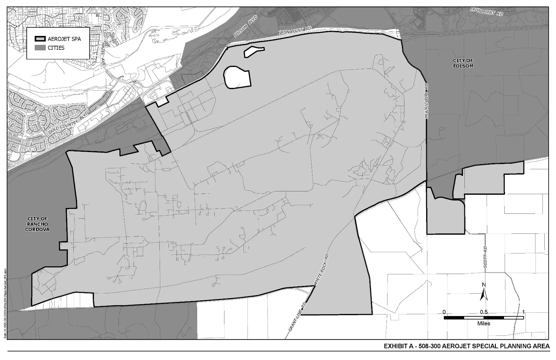
Exhibit “B” SPA Designations
Section titled “Exhibit “B” SPA Designations”Amended January 21, 2021
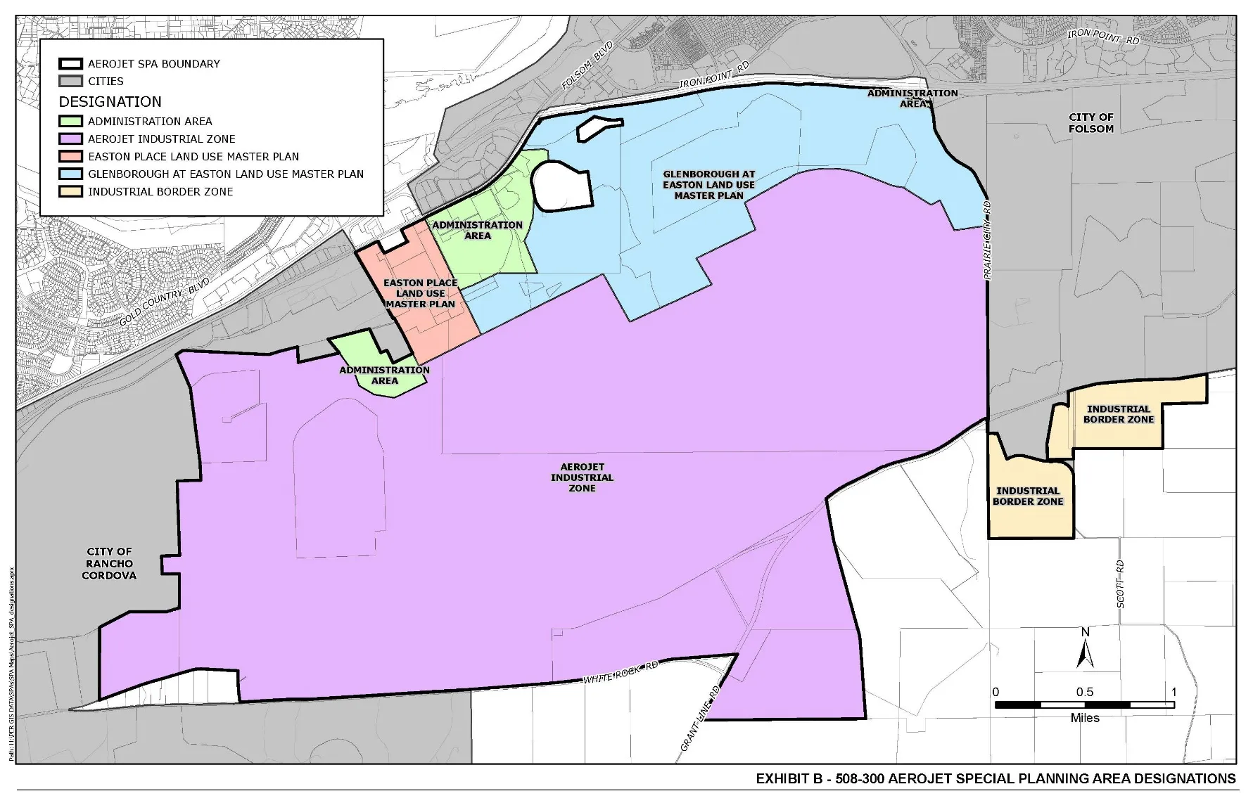
Exhibit “C” Uses Permitted Pursuant to this Ordinance
Section titled “Exhibit “C” Uses Permitted Pursuant to this Ordinance”MP USES ALLOWED WITHIN THE AEROJET SPA
Unless otherwise noted, footnotes shall be those found in the Commercial Land Use Tables; Title II, Chapter 25, Article 2.
| Use Type | Use | Permitted/Footnote |
|---|---|---|
| A. Automotive Sales, Services, Repair | 2. Auto rental or lease agency, including limousine service | 37 |
| B. Business Service | 1. Addressing and mailing services | X |
| B. Business Service | 2. Advertising business | X |
| B. Business Service | 3. Alarm/warning system - sales and service | X |
| B. Business Service | 7. Blueprinting-Photostatting service | X |
| B. Business Service | 8. Computer programming/software and system design | X |
| B. Business Service | 9. Computer sales, rental and lease | 14 |
| B. Business Service | 10. Computer service and training | X |
| B. Business Service | 11. Data processing service (see Section 130-53) | X |
| B. Business Service | 12. Delivery service | X |
| B. Business Service | 13. Disinfecting-fumigating service | X |
| B. Business Service | 14. Drafting service | X |
| B. Business Service | 18. Janitorial service | X |
| B. Business Service | 19. Locksmith - safe repair shop | X |
| B. Business Service | 19.5 Mail or delivery service pick-up station | 36 |
| B. Business Service | 20. Locksmith - key and lock shop | X |
| B. Business Service | 21. Mail order business | X |
| B. Business Service | 22. Messenger service | X |
| B. Business Service | 24. Pest control service | X |
| B. Business Service | 25. Photocopy service | 49 |
| B. Business Service | 26. Print shop | X |
| B. Business Service | 27. Printing plant | X |
| B. Business Service | 29. Sign, on-site | X |
| B. Business Service | 30. Stenographic service | X |
| B. Business Service | 31. Studio - radio, television, recording | X |
| B. Business Service | 32. Telegraph office | X |
| B. Business Service | 34. Ticket agency | X |
| B. Business Service | 35. Wholesale distributor’s service facility | 14 |
| C. Health Services | 11. Laboratory - medical, dental or optical | X |
| C. Health Services | 12. Laboratory - research, analysis | AA |
| C. Health Services | 13. Medical or dental office | 14 |
| C. Health Services | 17. Orthopedic Appliances sales/service | X |
| D. Personal Services | 4. Child care center | 49 |
| D. Personal Services | 9. Reducing-body building/aerobics studio | 37 |
| D. Personal Services | 10. Shoe shine parlor | X |
| D. Personal Services | 11. Studio - dance, voice, music, gymnastics | 37 |
| D. Personal Services | 12. Tailor | X |
| D. Personal Services | 13.5. Wedding Chapel | 37 |
| D. Personal Services | 15. Dating service (computerized video matching) | X |
| E. Miscellaneous Services | 6. Laboratory, materials testing | 14 |
| E. Miscellaneous Services | 7. Laundromat, self-service | X |
| E. Miscellaneous Services | 8. Laundry or cleaning agency, retail (on-site cleaning permitted) | X |
| E. Miscellaneous Services | 9. Laundry or cleaning pick-up station | X |
| E. Miscellaneous Services | 11. Parking lot or garage as primary use | 48 |
| E. Miscellaneous Services | 12. Photography studio, including incidental processing | X |
| E. Miscellaneous Services | 13. Picture framing shop | X |
| E. Miscellaneous Services | 15. Storage building-mini | X |
| E. Miscellaneous Services | 18. Travel agency | X |
| E. Miscellaneous Services | 19. Veterinarian-animal hospital | X |
| E. Miscellaneous Services | 20. Warehousing and storage | X |
| E. Miscellaneous Services | 21. Welding shop | 14 |
| F. Repair Services (See Section A for auto repair) | 1. Appliance repair shop | X |
| F. Repair Services (See Section A for auto repair) | 4. Shoe repair shop | X |
| F. Repair Services (See Section A for auto repair) | 5. Television and radio repair shop | X |
| G. Eating/Drinking/Lodging | 6. Delicatessen | 49 |
| G. Eating/Drinking/Lodging | 11. Restaurant-coffee shop-cafeteria | 49 |
| G. Eating/Drinking/Lodging | 12. Soda fountain-ice cream parlor | 37 |
| G. Eating/Drinking/Lodging | 13. Snack bar incidental to a park, boat dock, other water-oriented use | 49 |
| H. Entertainment/Recreation Services | 21. Physical fitness studio | 37 |
| H. Entertainment/Recreation Services | 23. Recreation facility, indoor | 37 |
| H. Entertainment/Recreation Services | 24. Recreation facility, outdoor | 14 |
| I. Food, Drug, Liquor Sales | 13. Prescription pharmacy | 49 |
| J. General Merchandise Sales | 22. Newspaper-magazine stand | X |
| K. Home Accessories and Services | 4. Floor covering, drapery or upholstery store | 37 |
| K. Home Accessories and Services | 5. Furniture cleaning, refinishing, reupholstery shop | 37 |
| K. Home Accessories and Services | 8. Interior decorator’s service yard and workshop | 14 |
| L. Recreation Equipment Sales | 10. Saddlery shop | X |
| M. Manufacturing/Processing | 1. Assembly - light manufacturing | 40 |
| M. Manufacturing/Processing | 4. Cabinet shop | 14 |
| M. Manufacturing/Processing | 9. Machine shop | 14 |
| M. Manufacturing/Processing | 10. Photographic processing plant, wholesale facility | X |
| M. Manufacturing/Processing | 11. Recycling center | X |
| N. Membership Organizations | 1. Church | 37 |
| N. Membership Organizations | 3. Labor union temple | 37 |
| N. Membership Organizations | 4. Lodge-fraternal hall | 37 |
| O. Offices | 1. Accountants, bookkeepers office | AA |
| O. Offices | 2. Bank, savings and loan, finance, loan, credit office | AA |
| O. Offices | 3. Building trades contractors office | AA |
| O. Offices | 4. Business or professional office | AA |
| O. Offices | 5. Collection, counseling, personnel office | AA |
| O. Offices | 6. Insurance office | AA |
| O. Offices | 8. Medical or dental office | AA |
| O. Offices | 9. Public relations or advertising | AA |
| O. Offices | 10. Real estate office | AA |
| P. Public Facilities | 1. Privately -owned uses within public and government-owned buildings, facilities and grounds | 42 |
| P. Public Facilities | 2. Public and government-owned building and facility, federal and state | X |
| P. Public Facilities | 3. Public and government-owned buildings and facilities other than federal and state | 14 |
| P. Public Facilities | 4. Public and government uses, other than Federal and State, within privately-owned buildings, facilities and grounds | 41 |
| P. Public Facilities | 4.5. Federal and State uses within privately-owned buildings, facilities, and grounds | X |
| P. Public Facilities | 5. Public utility and public service facility | 39 |
| R. Residential | 2. Home occupation | X |
| R. Residential | 3. Residence of a caretaker, proprietor or owner of a permitted use | 37 |
| S. Schools | 1. Business school | X |
| S. Schools | 2. Charm, culture school | X |
| S. Schools | 4. Driving school | X |
| S. Schools | 5. Other private school | 14 |
| S. Schools | 8. Self-defense, judo, boxing, gymnastics, swimming or similar activities | 37 |
| S. Schools | 9. Trade school | 14 |
| T. Transportation Facilities and Services | .7 Parking lot/garage (primary use) | 48 |
| U. Permits | 1. Certificate of nonconforming use | X |
| U. Permits | 2. Home occupation | X |
| U. Permits | 3. Special development permit | 14 |
| U. Permits | 5. Temporary uses | 8 |
*See Industrial Tables for additional uses.
SPECIAL CONDITION FOR MP USE TABLE
AA Permitted, provided that the total net office uses, wherever such office uses may, from time to time, be located on the property within this Special Planning Area do not exceed approximately 4.6 million square feet (existing office uses, as defined in Section 508-303(c) of this Special Planning Area Ordinance). Any reactivated or relocated office use shall be (c) located within the administrative area of the subject property, which is more particularly described in Section 508-313, Exhibit “D” of this Special Planning Area Ordinance, or (d) if located outside said administrative area, the total net office uses outside said administrative area shall not exceed 250,000 square feet and shall be located within areas of the subject property that have been historically used for office purposes. If such office use exceeds said 4.6 million square feet in said administrative area or exceeds said 250,000 square feet outside of said administrative area, it is considered a new use and is subject to issuance of a conditional use permit pursuant to Section 508-305 hereof. Relocated office uses shall not be located within 500 feet of the White Rock Road Special Planning Area without the issuance of a conditional use permit.
M-2 USES ALLOWED WITHIN THE AEROJET SPA
Footnotes shall be those found in the Industrial Land Use Tables; Title II, Chapter 30, Article 2
| Use Type | Use | Permitted/Footnote |
|---|---|---|
| A. Autos and Trucks | 1. Painting | 1 |
| A. Autos and Trucks | 2. Reconditioning | 1 |
| A. Autos and Trucks | 3. Repair and overhauling | 1 |
| A. Autos and Trucks | 5. Repair garage, machine repair and overhaul | 1 |
| A. Autos and Trucks | 6. Tire shop, including sales and installation | 1 |
| A. Autos and Trucks | 7. Inspection station | 1 |
| A. Autos and Trucks | 8. Automobile service station | 6 |
| A. Autos and Trucks | 9. Auto and truck rental or lease agency | 1 |
| A. Autos and Trucks | 11. Antique auto, storage and rebuilding | 1 |
| A. Autos and Trucks | 12. Car wash without gas pumps | X |
| A. Autos and Trucks | 13. Bus and freight depot and truck terminal | 1 |
| A. Autos and Trucks | 14. Mobilehome, commercial coach - storage | 1 |
| A. Autos and Trucks | 16. Auto and Truck Auction | 12 |
| B. Amusements | 3. Driving ranges | 2 |
| B. Amusements | 4. Shooting galleries | 2 |
| B. Amusements | 5. Shooting ranges | 2 |
| B. Amusements | 6. Race tracks | 2 |
| C. Animal and Fiber Processing | 5. Honey extraction | X |
| C. Animal and Fiber Processing | 14. j. Drugs | 1 |
| D. Commercial Uses | 1. Bottled gas sale & related storage | X |
| D. Commercial Uses | 2. Building trades contractor’s office, service yard; workshop | 1 |
| D. Commercial Uses | 3. Coffee shop, snack bar, delicatessen, cafeteria when located as one tenant in a building and not occupying more than 15% of the total floor area | X |
| D. Commercial Uses | 4. Firewood, fuel - sales and storage | 1 |
| D. Commercial Uses | 5. Hay, seed, grain and farm equipment store | 1 |
| D. Commercial Uses | 7. Parts sales when incidental to a permitted use and sales and stockroom area does not exceed 25% of the total floor area. | X |
| D. Commercial Uses | 8. Offices, when incidental to a permitted use and does not exceed 25% of the total floor area of the permitted use | X |
| E. Government Uses, Buildings and Airports | 1. Federal and state buildings, facilities, and grounds | X |
| E. Government Uses, Buildings and Airports | 2. Other government and public buildings, facilities, and grounds | 12 |
| E. Government Uses, Buildings and Airports | 3. Public and government uses within privately-owned buildings, facilities, and grounds | 16 |
| E. Government Uses, Buildings and Airports | 4. Privately-owned uses within public and government-owned buildings, facilities, and grounds | 17 |
| E. Government Uses, Buildings and Airports | 5. Public use airports, aircraft landing fields, and heliports 4 | 4 |
| E. Government Uses, Buildings and Airports | 6. Local agency building, grounds (defined, Government Code Section 53090) 12 | 12 |
| E. Government Uses, Buildings and Airports | 7. School district nonclassroom facilities 12 | 12 |
| E. Government Uses, Buildings and Airports | 8. Private airports, landing fields and heliports approved by CAD and FAA 12 | 12 |
| F. Industrial Yard Use | 3. Truck terminal yard | X |
| F. Industrial Yard Use | 8. Contractor’s storage yard | 1 |
| F. Industrial Yard Use | 10. Public utility service yard | 1 |
| F. Industrial Yard Use | 11. Heavy equipment storage, sales, rental, service and repair yard | 1 |
| F. Industrial Yard Use | 14. Used building materials scrap or junk yard | 7 |
| F. Industrial Yard Use | 15. Building materials sales yard | 9 |
| F. Industrial Yard Use | 16. Military surplus equipment and goods | 8 |
| F. Industrial Yard Use | 17. Parking yard for damaged vehicles | 8 |
| F. Industrial Yard Use | 17.5 Parking yard for towed operable vehicles (requires on-site office for vehicle retrieval | 8 |
| F. Industrial Yard Use | 18. Recycling center | X |
| F. Industrial Yard Use | 19. Recycling plant | 7 |
| F. Industrial Yard Use | 20. Hazardous waste transfer, storage, disposal facility (TSD) | 3 |
| F. Industrial Yard Use | 22. Storage of dismantled vehicles | 7 |
| F. Industrial Yard Use | 23. Moved building storage, (long term) | 3 |
| F. Industrial Yard Use | 24. Moved building storage, temporary (7 days or less) | 20 |
| G. Manufacturing and Fabrication Uses | 1. Alcohol, industrial or grain manufacture | X |
| G. Manufacturing and Fabrication Uses | 3. Asphalt manufacture or refining | X |
| G. Manufacturing and Fabrication Uses | 4. Blast furnace or coke oven | X |
| G. Manufacturing and Fabrication Uses | 5. Boiler works | X |
| G. Manufacturing and Fabrication Uses | 6. Brick, adobe, tile, terra cotta or concrete products | X |
| G. Manufacturing and Fabrication Uses | 7. Concrete or cement products manufacture | X |
| G. Manufacturing and Fabrication Uses | 8. Ice manufacture and cold storage | X |
| G. Manufacturing and Fabrication Uses | 11. Ore reduction | X |
| G. Manufacturing and Fabrication Uses | 12. Paint, oil (including linseed), shellac, turpentine, lacquer or varnish manufacture | X |
| G. Manufacturing and Fabrication Uses | 15. Plastic manufacture | X |
| G. Manufacturing and Fabrication Uses | 17. Quarry or stone mills | X |
| G. Manufacturing and Fabrication Uses | 18. Railroad repair shops | X |
| G. Manufacturing and Fabrication Uses | 24. Machinery Shop Uses: (a) Blacksmith shops | 1 |
| G. Manufacturing and Fabrication Uses | 24. Machinery Shop Uses: (b) Cabinet or carpenter shops | 1 |
| G. Manufacturing and Fabrication Uses | 24. Machinery Shop Uses: (c) Electric motor rebuilding | 1 |
| G. Manufacturing and Fabrication Uses | 24. Machinery Shop Uses: (d) Machine shops | 1 |
| G. Manufacturing and Fabrication Uses | 24. Machinery Shop Uses: (e) Sheet metal shops | 1 |
| G. Manufacturing and Fabrication Uses | 24. Machinery Shop Uses: (f) Welding shops | 1 |
| G. Manufacturing and Fabrication Uses | 24. Machinery Shop Uses: (g) Plumbing shops | 1 |
| G. Manufacturing and Fabrication Uses | 24. Machinery Shop Uses: (h) Manufacturing, compounding, assembly, or treatment of articles or 1 merchandise from previously prepared metals | 1 |
| G. Manufacturing and Fabrication Uses | 26. Chemical manufacture 3 | 3 |
| G. Manufacturing and Fabrication Uses | 29. Aircraft engine testing 3 | 3 |
| G. Manufacturing and Fabrication Uses | 30. Rocket testing facilities 3 | 3 |
| G. Manufacturing and Fabrication Uses | 31. Electric or neon sign manufacture X | X |
| G. Manufacturing and Fabrication Uses | 32. Boat building X | X |
| G. Manufacturing and Fabrication Uses | 33. Manufacturing, compounding, assembly or treatment of articles or merchandise from the following previously prepared materials: (a) bone | 1 |
| G. Manufacturing and Fabrication Uses | 33. Manufacturing, compounding, assembly or treatment of articles or merchandise from the following previously prepared materials: (b) Canvas | 1 |
| G. Manufacturing and Fabrication Uses | 33. Manufacturing, compounding, assembly or treatment of articles or merchandise from the following previously prepared materials: (c) Cellophane | 1 |
| G. Manufacturing and Fabrication Uses | 33. Manufacturing, compounding, assembly or treatment of articles or merchandise from the following previously prepared materials: (d) Cloth | 1 |
| G. Manufacturing and Fabrication Uses | 33. Manufacturing, compounding, assembly or treatment of articles or merchandise from the following previously prepared materials: (e) Cork | 1 |
| G. Manufacturing and Fabrication Uses | 33. Manufacturing, compounding, assembly or treatment of articles or merchandise from the following previously prepared materials: (f) Feathers | 1 |
| G. Manufacturing and Fabrication Uses | 33. Manufacturing, compounding, assembly or treatment of articles or merchandise from the following previously prepared materials: (g) Felt | 1 |
| G. Manufacturing and Fabrication Uses | 33. Manufacturing, compounding, assembly or treatment of articles or merchandise from the following previously prepared materials: (h) Fiber | 1 |
| G. Manufacturing and Fabrication Uses | 33. Manufacturing, compounding, assembly or treatment of articles or merchandise from the following previously prepared materials: (i) Fur | 1 |
| G. Manufacturing and Fabrication Uses | 33. Manufacturing, compounding, assembly or treatment of articles or merchandise from the following previously prepared materials: (j) Hair | 1 |
| G. Manufacturing and Fabrication Uses | 33. Manufacturing, compounding, assembly or treatment of articles or merchandise from the following previously prepared materials: (k) Horn | 1 |
| G. Manufacturing and Fabrication Uses | 33. Manufacturing, compounding, assembly or treatment of articles or merchandise from the following previously prepared materials: (l) Glass | 1 |
| G. Manufacturing and Fabrication Uses | 33. Manufacturing, compounding, assembly or treatment of articles or merchandise from the following previously prepared materials: (m) Leather | 1 |
| G. Manufacturing and Fabrication Uses | 33. Manufacturing, compounding, assembly or treatment of articles or merchandise from the following previously prepared materials: (n) Paper (no milling) | 1 |
| G. Manufacturing and Fabrication Uses | 33. Manufacturing, compounding, assembly or treatment of articles or merchandise from the following previously prepared materials: (o) Precious or semi-precious stones or metal | 1 |
| G. Manufacturing and Fabrication Uses | 33. Manufacturing, compounding, assembly or treatment of articles or merchandise from the following previously prepared materials: (p) Plaster | 1 |
| G. Manufacturing and Fabrication Uses | 33. Manufacturing, compounding, assembly or treatment of articles or merchandise from the following previously prepared materials: (q) Plastic | 1 |
| G. Manufacturing and Fabrication Uses | 34. Rubber and metal stamps, musical instruments, toys and novelties 1 | 1 |
| G. Manufacturing and Fabrication Uses | 35. Lightweight nonferrous metal casting foundry 12 | 12 |
| G. Manufacturing and Fabrication Uses | 36. Ceramic products using only previously pulverized clay and fired in kilns using electricity or gas only | 1 |
| G. Manufacturing and Fabrication Uses | 37. Air Separation Plant | 2 |
| H. Processing and Assembly Uses | 5. Printing shops, lithography, publishing | X |
| H. Processing and Assembly Uses | 10. Assembly of small electrical and electronic equipment | X |
| H. Processing and Assembly Uses | 11. Assembly of plastic items from finished plastic | X |
| H. Processing and Assembly Uses | 12. Rubber fabrication or products made from finished rubber | 1 |
| H. Processing and Assembly Uses | 14. Photographic chemical processing and wholesale distribution | X |
| I. Storage and Warehouse Uses | 1. Petroleum storage | X |
| I. Storage and Warehouse Uses | 2. Storage and distribution of bottled gas | X |
| I. Storage and Warehouse Uses | 3. Wholesaling and warehousing | X |
| I. Storage and Warehouse Uses | 6. Automobile, recreational vehicle and boat storage | 14 |
| I. Storage and Warehouse Uses | 7. Storage building-mini | X |
| I. Storage and Warehouse Uses | 8. Moving and storage | X |
| I. Storage and Warehouse Uses | 9. General storage | X |
| J. Services | 1. Janitorial | 1 |
| J. Services | 2. Pest control | 1 |
| J. Services | 3. Disinfecting or fumigating | 1 |
| J. Services | 4. Gardening and landscaping; service yard and work shop | 1 |
| J. Services | 5. Trailer sale, rental service (utility trailers only/not for habitation) | 1 |
| J. Services | 6. Tree service | 1 |
| J. Services | 7. Delivery service | X |
| J. Services | 8. Taxicab service and storage | 14 |
| J. Services | 9. Laboratory, medical, dental, or optical | X |
| J. Services | 10. Laboratory, research, experimental | X |
| J. Services | 11. Laboratory, materials testing | X |
| J. Services | 12. Appliance, radio and television, repair shop | 1 |
| J. Services | 13. Grinding—sharpening service | 1 |
| J. Services | 14. Blueprinting - Photostatting service | X |
| J. Services | 15. Boat service and repair | 1 |
| J. Services | 16. Upholstery, furniture cleaning | 1 |
| J. Services | 17. Equipment rental agency | 1 |
| J. Services | 18. Gunsmith | X |
| J. Services | 19. Pool service | 1 |
| J. Services | 20. Drafting service | X |
| J. Services | 21. Locksmith, safe repair shop | X |
| J. Services | 22. Towing service | 1 |
| J. Services | 23. Tree service | 1 |
| J. Services | 24. Child care center | 14 |
| J. Services | 25. Security service | X |
| J. Services | 26. Video tape - editing, processing | X |
| K. Miscellaneous | 3. Cafe/restaurant - free standing or occupying more than 15% of a building (See Section 230-11 D.4.) | 12 |
| K. Miscellaneous | 4. Trade school | X |
| K. Miscellaneous | 5. Veterinary hospital | 1 |
| K. Miscellaneous | 6. Agricultural uses | 1 |
| K. Miscellaneous | 7. Home occupations | X |
| K. Miscellaneous | 8. The nonresidential uses listed in Section 225-11 (Commercial Table) except those non-residential uses listed in this matrix | 12 |
| K. Miscellaneous | 8.5. The nonresidential uses listed in Section 225-13 (Table III), except those nonresidential uses listed in this matrix | 13 |
| K. Miscellaneous | 9. Signs, as provided in Title III, Chapter 35, Article 1, General Provisions | X |
| K. Miscellaneous | 10. Signs, off-site, as provided in Title III, Chapter 35, Article 1, Section 335-12 | 21 |
| K. Miscellaneous | 10.5. Sign relocation, off-site | 22 |
| K. Miscellaneous | 11. Signs, on-site, as provided in Title III, Chapter 35, Articles 2.1 and 2.2 | X |
| K. Miscellaneous | 12. Special permits | 12 |
| K. Miscellaneous | 13. Residence for night watchman or caretaker | 14 |
| K. Miscellaneous | 14. Irrigation Disposal of Wastewater as defined in Section 130-99.1. | 13 |
| K. Miscellaneous | 15. Lagoon Disposal of Wastewater as defined in Section 130-103-1. | 13 |
| K. Miscellaneous | 17. Public utility & public service facility | 15 |
| K. Miscellaneous | 18. Condominiums, industrial | X |
| K. Miscellaneous | 19. Temporary concession stand | 19 |
| K. Miscellaneous | 20. Labor union hall | X |
Exhibit “D” Carve-Out Area
Section titled “Exhibit “D” Carve-Out Area”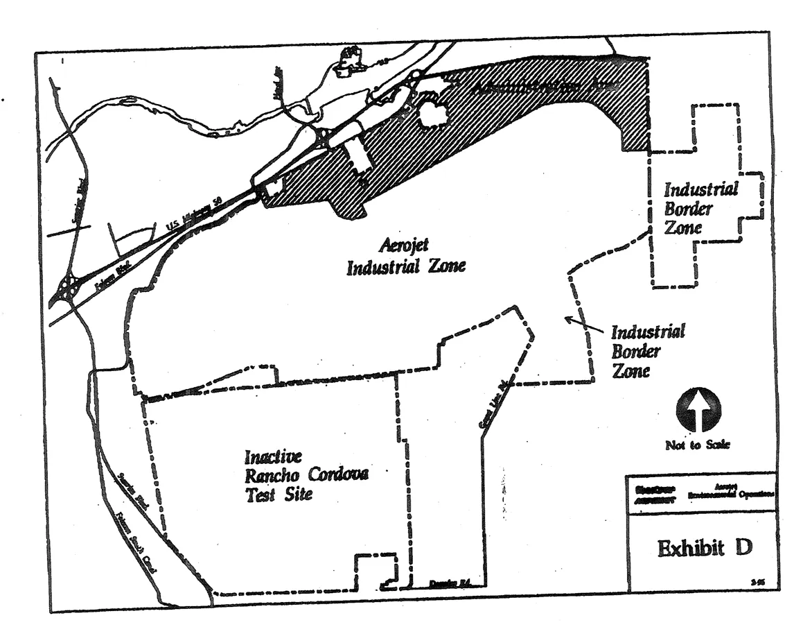
Exhibit “E” Conditions - Easton Place and Glenborough
Section titled “Exhibit “E” Conditions - Easton Place and Glenborough”Land Use
Section titled “Land Use”Aesthetics
Section titled “Aesthetics”Hydrology & Water Quality
Section titled “Hydrology & Water Quality”Air Quality
Section titled “Air Quality”Noise Mitigation
Section titled “Noise Mitigation”Biological Resources
Section titled “Biological Resources”Cultural Resources
Section titled “Cultural Resources”Geology and Soils
Section titled “Geology and Soils”Climate Change
Section titled “Climate Change”Streets and Right-of-Way Dedication
Section titled “Streets and Right-of-Way Dedication”Alder Creek Corridor
Section titled “Alder Creek Corridor”Open Space Areas
Section titled “Open Space Areas”Community Resource Area
Section titled “Community Resource Area”Sewer Facilities
Section titled “Sewer Facilities”Sheriff
Section titled “Sheriff”Financing Mechanisms
Section titled “Financing Mechanisms”Non-Potable Water
Section titled “Non-Potable Water”Roadway Improvement Trigger Conditions
Section titled “Roadway Improvement Trigger Conditions”Easton Valley Parkway Corridor Study
Section titled “Easton Valley Parkway Corridor Study”Landscape Corridors
Section titled “Landscape Corridors”Energy Efficiency
Section titled “Energy Efficiency”Exhibit 314-A Land Use Master Plan for Glenborough at Easton
Section titled “Exhibit 314-A Land Use Master Plan for Glenborough at Easton”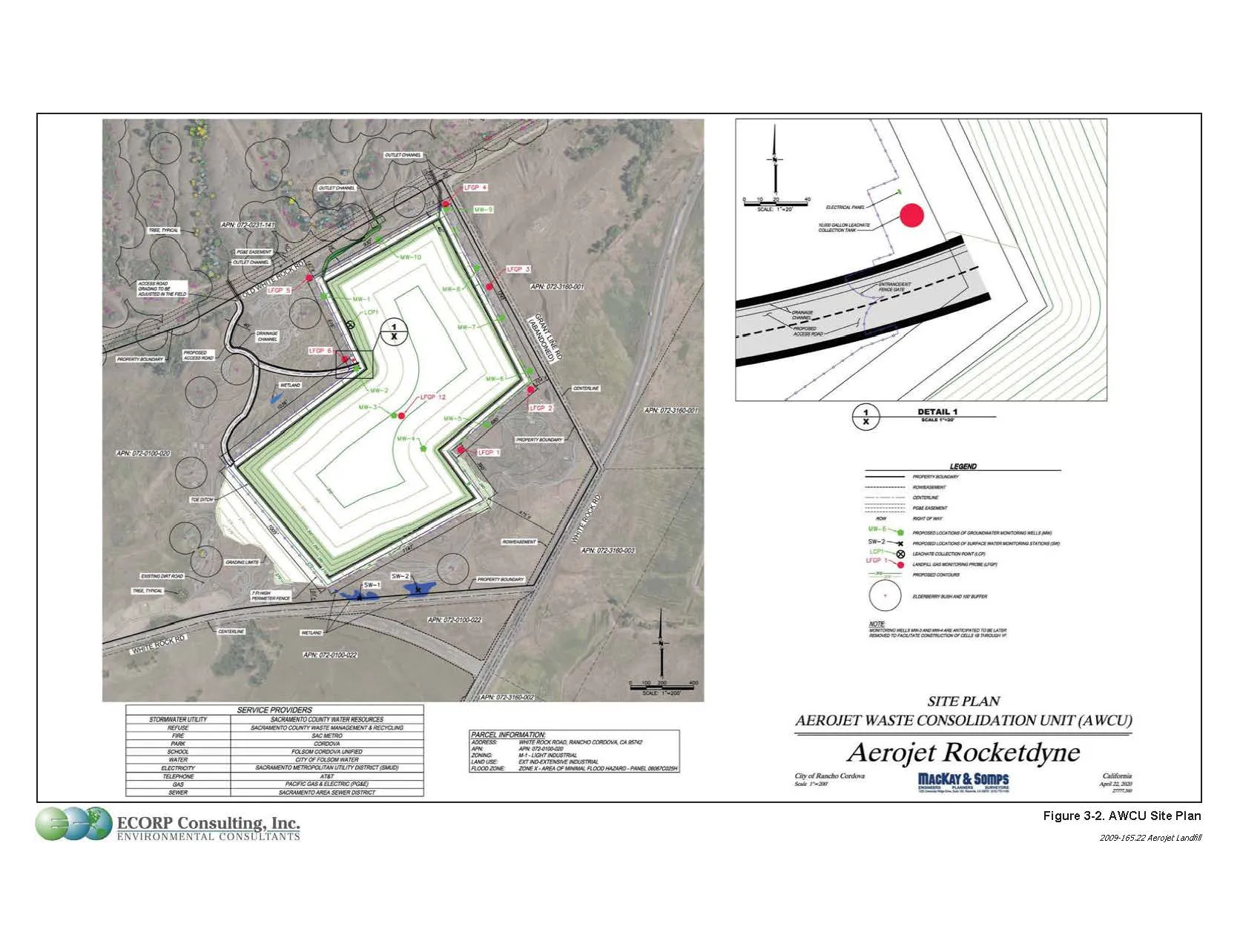
Exhibit 315-A Land Use Master Plan for Easton Place
Section titled “Exhibit 315-A Land Use Master Plan for Easton Place”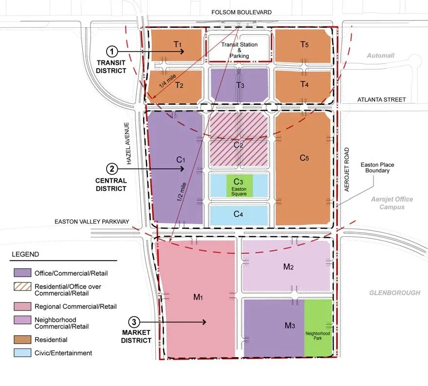
Exhibit “316-A” Easton Land Use Master Plan
Section titled “Exhibit “316-A” Easton Land Use Master Plan”PLEASE SEE SEPARATE ATTACHMENT
Exhibit “316-B” Glenborough Land Use Master Plan
Section titled “Exhibit “316-B” Glenborough Land Use Master Plan”PLEASE SEE SEPARATE ATTACHMENT
Exhibit “F” Conditions - Aerojet Waste Consolidation Unit
Section titled “Exhibit “F” Conditions - Aerojet Waste Consolidation Unit”Sacramento County, Office of Planning and Environmental Review (PER)
Section titled “Sacramento County, Office of Planning and Environmental Review (PER)”Air Quality
Section titled “Air Quality”Biological Resources
Section titled “Biological Resources”Cultural Resources
Section titled “Cultural Resources”Geology and Soils
Section titled “Geology and Soils”Sacramento County Environmental Management Department (EMD)
Section titled “Sacramento County Environmental Management Department (EMD)”Sacramento County Department of Transportation (DOT)
Section titled “Sacramento County Department of Transportation (DOT)”Sacramento County Department of Water Resources (Water Resources)
Section titled “Sacramento County Department of Water Resources (Water Resources)”Sacramento Municipal Utility District (SMUD)
Section titled “Sacramento Municipal Utility District (SMUD)”Advisory Notices
Section titled “Advisory Notices”These are advisories from County Departments or Agencies regarding fees or circumstance that may arise associated with the project requiring additional action by the applicant.
Water Resources
Section titled “Water Resources”Sacramento County Engineering - Survey Section
Section titled “Sacramento County Engineering - Survey Section”Exhibit “317-A” Aerojet Waste Consolidation Unit
Section titled “Exhibit “317-A” Aerojet Waste Consolidation Unit”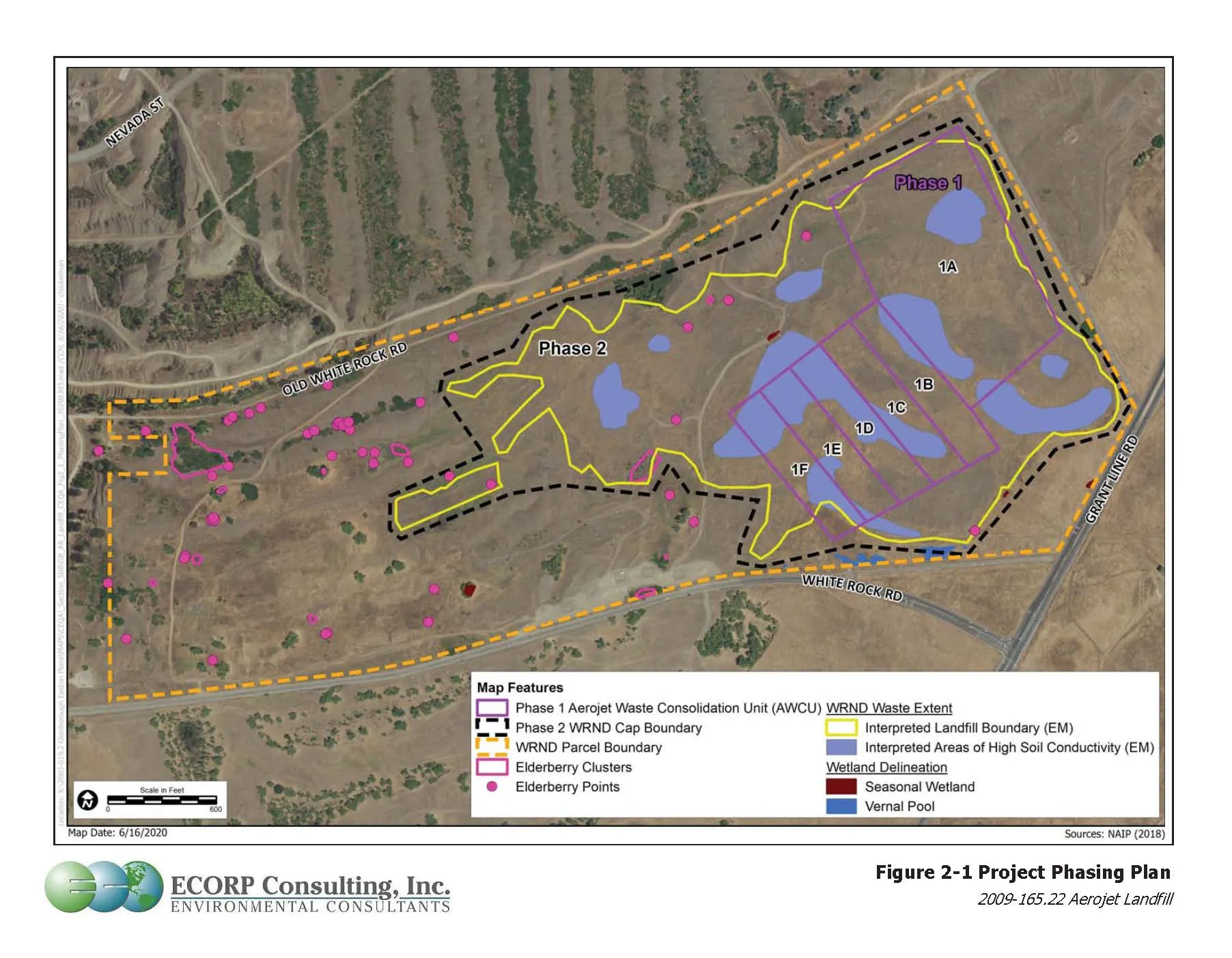
Exhibit “317-B” AWCU Service Area Boundary and Haul Routes
Section titled “Exhibit “317-B” AWCU Service Area Boundary and Haul Routes”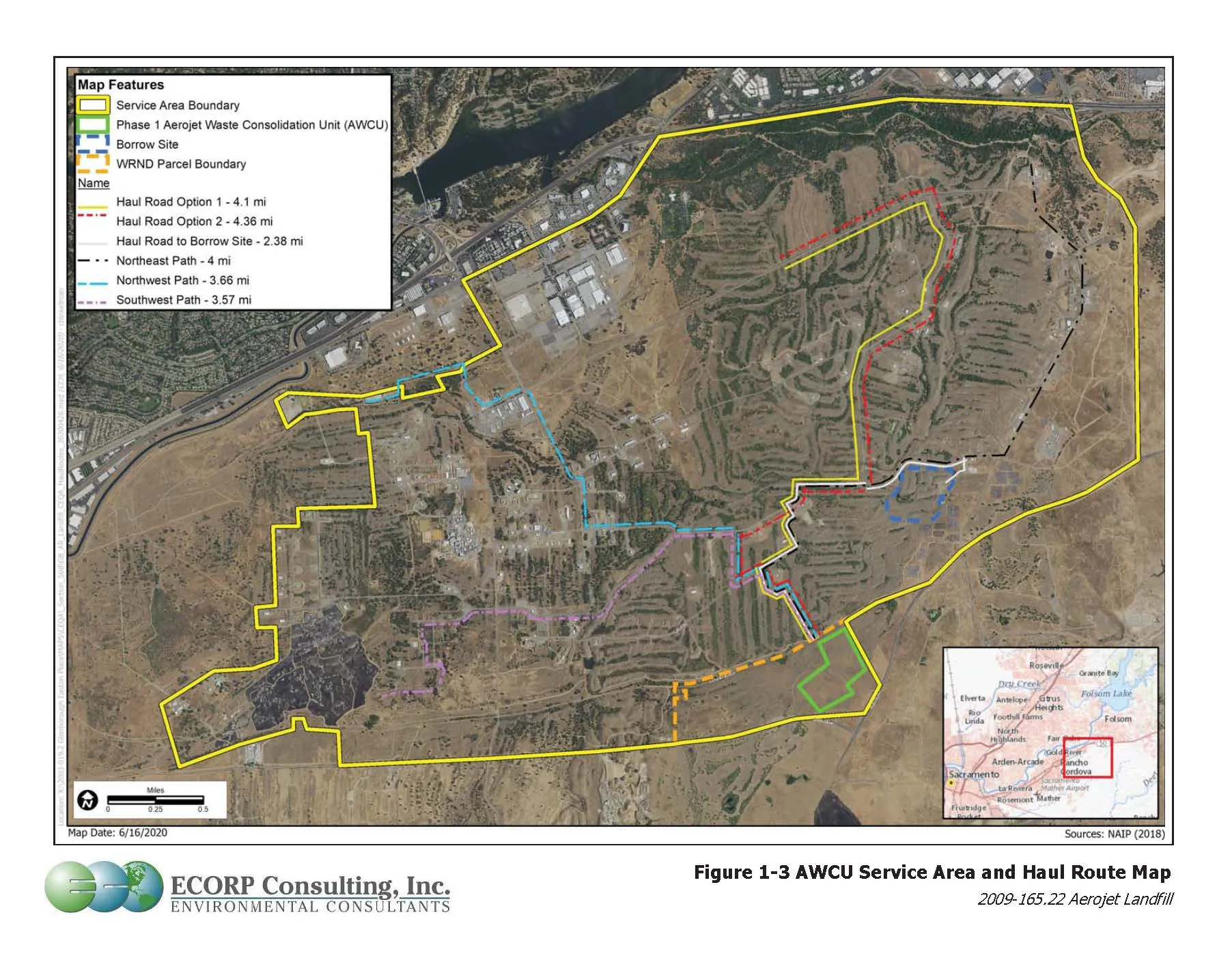
Exhibit “317-C” AWCU Site Plan
Section titled “Exhibit “317-C” AWCU Site Plan”
Exhibit “317-D” AWCU Landscape Plan
Section titled “Exhibit “317-D” AWCU Landscape Plan”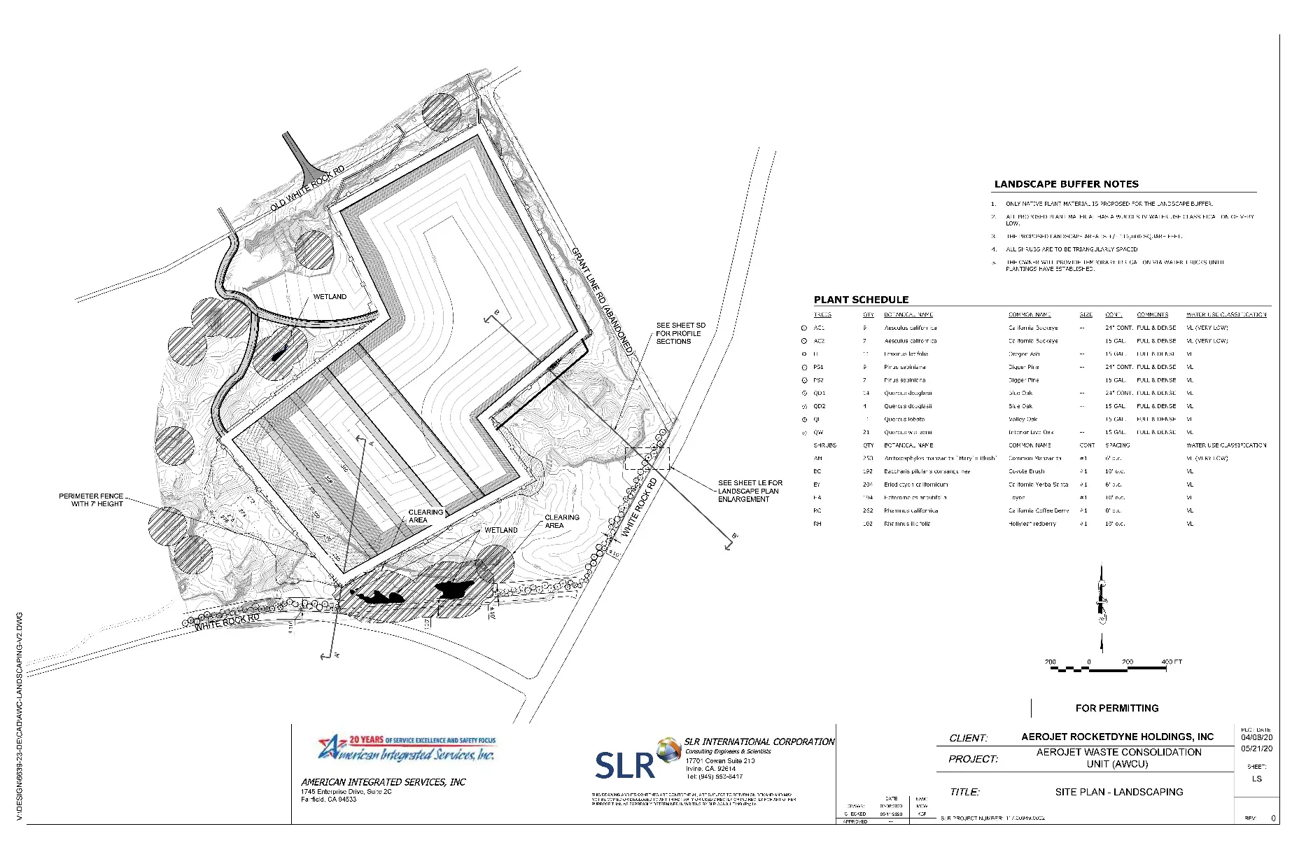
Exhibit “317-E” AWCU Landscape Plan Enlargement
Section titled “Exhibit “317-E” AWCU Landscape Plan Enlargement”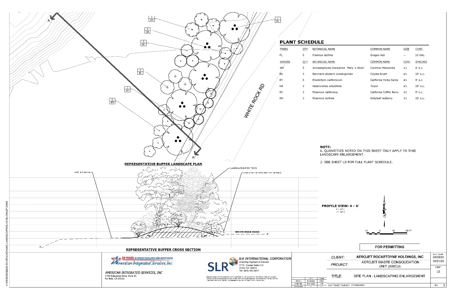
Exhibit “317-F” AWCU Landscape Plan Details
Section titled “Exhibit “317-F” AWCU Landscape Plan Details”