Cordova Hills SPA
Sacramento County Zoning Code
Cordova Hills Special Planning Area Ordinance
Section titled “Sacramento County Zoning Code Cordova Hills Special Planning Area Ordinance”Adopted April 23, 2013
Adopted by ZMA #5633 / PLNP2008-00142
613-10. INTENT.
Section titled “613-10. INTENT.”It is the intent of the Board of Supervisors in adopting the Cordova Hills Special Planning Area (SPA) Ordinance to master plan the subject property consistent with the policies of the County General Plan and recognize the uniqueness of the SPA for the opportunity it provides to master plan a new community containing a university/college campus site along the Grant Line Road corridor with a mix of uses that would otherwise not be available with conventional zoning. The identified land use districts are designed to take advantage of the unique location and topography of the site, as well as create attractive places in which to live, work, study and shop.
In addition, the ordinance is intended to provide greater flexibility in permitted and conditionally permitted uses and in applicable development standards to promote a wide variety of housing types with increased average and flexible densities that are not available under typical zoning. The SPA will ensure that the intensity, configuration and design of land uses are supportive of high quality transit services, biking and pedestrian activity in order to make significant progress toward reducing traffic congestion, vehicles miles traveled, and air pollution, especially greenhouse gases, while providing diversity in the housing supply, local and regional shopping opportunities, a new site for a higher education facility, and preserving significant open space and wildlife habitat resources within the SPA consistent with habitat conservation planning efforts.
613-11. APPLICABILITY.
Section titled “613-11. APPLICABILITY.”The Cordova Hills Master Plan document (Section 61318.7) is hereby incorporated in full by this reference. The provisions of this Article, including the Cordova Hills Master Plan, shall apply to the land area shown in Section 613-18.1. In any case, where this Article or the Cordova Hills Master Plan document does not provide direction or regulation regarding a specific type of land use or development standard, all applicable provisions of the Sacramento County Zoning Code shall apply. To the extent that any provisions of this Article conflict with other provisions of the Sacramento County Zoning Code, the provisions of this Article shall prevail.
613-12. DEFINITIONS.
Section titled “613-12. DEFINITIONS.”For the purposes of this Article, the following definitions apply:
Cordova Hills Master Plan: The Cordova Hills Master Plan (Section 613-18.7) is the regulatory document for Cordova Hills which includes text with goals and policies, land use plan, development standards, design guidelines and development regulations. The Master Plan establishes a development framework for land use, affordable housing, resource protection, circulation, utilities and services, implementation, and design. The boundaries of the Cordova Hills Master Plan are depicted in Section 613-18.1 and the land uses are depicted in Section 61318.2
Land Use Plan: The Illustrative Land Use Plan, as depicted in Section 613-18.2, summarizes the distribution of land uses for Cordova Hills. The Land Use Plan portrays the overall pattern and intensity of land use, and circulation that serves the proposed uses.
Circulation Plan: The Cordova Hills Circulation Plan, as depicted in Section 613-18.3, integrates a variety of streets, trails, bikeways and NEV lanes configured to provide an adequate level of service for the planned land use densities and traffic loads.
Parks Plan: The Cordova Hills Parks Plan, as depicted in Section 613-18.4, designates areas as active parks, including a 50-acre sports park, an 18.5 acre community park and six neighborhood parks ranging from four to six acres.
Air Quality Management Plan: The Air Quality Management Plan requires the implementation of project-specific emission reductions for developments proposed in the Cordova Hills project area, consistent with General Plan Policy AQ-4.
Greenhouse Gas Reduction Plan: The Greenhouse Gas (GHG) Reduction Plan which includes project features designed to reduce GHG emissions directly or indirectly, per development standards and design guidelines described in the Cordova Hills SPA.
Public Facilities Financing Plan: The financing plan, as referenced in the Cordova Hills Master Plan, identifies the infrastructure improvements necessary to support the proposed level of development and describes the methods of financing the infrastructure. Separate actions will likely be necessary to establish assessment districts, fee programs and/or other funding programs.
Development Agreement: The Agreement which insures to the County that the extraordinary benefits of the Cordova Hills project are carried out over the life of the project in return for the vesting of development rights over a 30 year period. The Development Agreement vests the Cordova Hills Master Plan and design standards.
613-13. VILLAGES DEFINED.
Section titled “613-13. VILLAGES DEFINED.”Cordova Hills is envisioned as a series of six ‘Villages’ and one University/College Campus Center (as depicted in Section 613-18.5), each with an individual architectural and landscape character and a separate set of ‘placemaking’ principles for community character, land use and housing mix, recreation, infrastructure, and open space. Each Village will have a distinct amenity. Existing land characteristics, such as flat or hilly terrain, help determine the locations for various types of urban forms and densities. The following summarizes the intent and purpose of each village.
- Town Center: Directly adjacent to Grant Line Road, the topography in this area is generally flat. This area is ideal for the Town Center and high-density neighborhoods that are envisioned to surround the Town Center's commercial core. This area will be a true mixed-use Village with approximately 966,000 sq. ft. of commercial uses and approximately 1,750 residential units. The Capital Southeast Connector could become a regional transportation corridor that will support the Town Center as a shopping and entertainment center for the southeast Sacramento County region. The Town Center will include shops, offices, lifestyle retail services, and restaurants.
- Ridgeline Village: The Ridgeline Village area is situated on a prominent down slope just below the ridge crest of the central bluff that falls eastward toward the Paseo Central. A mix of low to medium-low density residential housing types is envisioned for this area. Therefore, building pads of different sizes will be utilized in a step-down terrace formation. This method takes advantage of the natural slope, while maximizing the views onto the valley below. Two main pedestrian routes will connect the vernal pool Avoided Area to the Paseo Central. The Ridgeline Village will include a neighborhood retail center and will be surrounded to the east and west by open space Avoided Areas, providing a distinctive Village edge. The Ridgeline Village is envisioned as a transitional district between the Main Avoided Area to the west and East Valley district to the east. With commanding views to the east, this hillside neighborhood is a good location for mixed housing products, potentially including age-targeted housing.
- University Village: The University Village lies east of the University/College Campus Center. Adjacent and connected to the campus center by a pedestrian scaled mixed-use street, this Village will provide housing for students, staff and among others, and support for the adjacent retail. This Village is bounded by a bluff edge and open space corridor to the west and the Paseo Central to the east. It features traditional neighborhood design character with a neighborhood park as the focal point. This Village will be an active retail and residential area and will house most of the off-campus residences, an elementary school, and a shopping and dining district oriented to the campus center. The natural grade in this area falls generally southward and eastward towards the central drainage corridor. The grading concept would be compatible with the proposed medium-high density residential neighborhoods that are envisioned for this Village.
- East Village: The East Valley Village will consist of an approximate 14.5-acre neighborhood serving retail center with an adjacent 18.5-acre community park as the Village's core. The East Valley Village will be a family oriented Village with a school, retail and park as a focal point. It is one of the largest Villages in Cordova Hills, and will feature local retail and services for the Village and surrounding neighborhoods. Trails and open space extending through the East Valley Village will connect to the Paseo Central along its west boundary. The ridgeline feature extending north to south forms the eastern boundary of the Village
- Creekside Village: Creekside Village will contain two neighborhood parks of at least 5 acres each in size and mixed residential densities. The Creekside Village is envisioned as a quiet, move-up community with open space to the east, south and west. Mid-density housing in a variety of configurations and styles will help to preserve the rolling landform in the Creekside Village.
- Estates Village: The Estates Village abuts the Urban Services Boundary. This Village is envisioned to have the lowest residential density housing consisting primarily of large lots to respect the transition to the Urban Services Boundary. A ridgeline feature that separates the Estates from the East Valley Village will be recontoured. This ridge will serve as an open space separation, and a natural gateway to the Estates. Residences will enjoy an open space view of the Deer Creek Hills drainage to the east and the distant Sierra Nevada. A relaxed, 'countryside' neighborhood will be created in the Estates Village with low residential densities, a more informal, rural street character, and a focus on the open, rural character of the surrounding open space. This Village, as well as many of the other Villages, includes a designated location for a central recreation area. Carson Creek borders it to the east, with interconnected open space as a common character feature.
- The Bufferlands: The bufferlands lies west of the University / College Campus Center and includes the sports park. Other potential uses permitted within its agricultural designation include a solar farm, district energy plant, corporation yard, park and ride lot, natural resource avoided area, agriculture, community gardens, sewer pump station, and water tanks. The sports park is planned directly west of the University/College Campus Center and conceptually includes sports fields, courts, picnic and playground areas, and parking.
- The University/ College Campus Center: Located on a plateau overlooking the valleys of Cordova Hills, the University / College Campus Center is envisioned to be a higher learning 'campus for the centuries.' The University/College Campus Center will occupy 223 acres and is a significant component of Cordova Hills. The University/College Campus Center is designed to accommodate a single institution, or a conglomerate of smaller institutions all within a coordinating framework of administration, services and common facilities that will encompass a broad range of disciplines from the arts and sciences to business, law, engineering, arts and medicine.
613-14. PERMITTED, CONDITIONALLY PERMITTED AND PROHIBITED USES.
Section titled “613-14. PERMITTED, CONDITIONALLY PERMITTED AND PROHIBITED USES.”The Cordova Hills Master Plan identifies sixteen land use classifications. These classifications have some features common to the Sacramento County Zoning Ordinance classifications, but each land use designation in Cordova Hills is a distinct designation that is fully described in the Cordova Hills Master Plan. Table 4.1 of the Cordova Hills Master Plan provides a summary of the land use classifications and the general list of permitted uses defined in the Master Plan. Each designation category allows a range of permitted land uses that, in some instances, overlap with other land use designations. The intent is to provide a blending, rather than a distinct separation, of uses and activities. Specific uses that are not included in Table 4.1, Summary of Land Use Designations and Permitted Uses, may be added through a Minor Master Plan Amendment as defined in Chapter 9, Section 9.2.2.2 of the Cordova Hills Master Plan.
613-15. DEVELOPMENT STANDARDS AND DESIGN GUIDELINES.
Section titled “613-15. DEVELOPMENT STANDARDS AND DESIGN GUIDELINES.”Section 4.3.2 of the Cordova Hills Master Plan provides a reference and summary of housing types, square footage requirements and densities for all housing units permitted in the Cordova Hills area. The housing types are also subject to Attached and Detached Standards that are presented in Tables 4.6, 4.7 and 4.8 of the Master Plan document, which are intended to define the desired urban form and character of neighborhoods within the Cordova Hills area. These tables include specific requirements for minimum lot sizes; width and depth; density; front side and rear yard setbacks; building heights and stories; parking and minimum floor area ratios. Non-Residential Standards are included in Table 4.9 of the Master Plan. Section 4.7 of the Master Plan includes a set of development standards to govern the solar farm, corporation maintenance yard, and other agricultural-related uses that are permitted within the Bufferlands.
Section 4.5 of the Cordova Hills Master Plan includes a set of design guidelines that are intended to be used in conjunction with the development standards included in Section 4.4 of the Master Plan. Together, these guidelines and standards will promote high quality site and building design.
613-16 CORDOVA HILLS MASTER PLAN AMENDMENTS.
Section titled “613-16 CORDOVA HILLS MASTER PLAN AMENDMENTS.”The Cordova Hills Master Plan is intended to be flexible in order to respond to changing conditions and expectations during the course of its implementation. During the long-term build-out of Cordova Hills, amendments to the adopted Master Plan may be necessary to respond to changing circumstances or to adapt some design guidelines or standards to special conditions on a particular site. To address this intent, Section 9 of Cordova Hills Master Plan provides for both minor and major Master Plan Amendments.
Any proposed amendments to the Master Plan can include, but are not limited to, changing land use designations, design criteria, development standards or policies, which may include amendments to one or more of the Exhibits identified in Section 613-18 or mitigation measures identified in Section 613-18.6. Amendments to this adopted Master Plan shall be categorized by the Planning Director as either a Major Amendment or a Minor Amendment. The Planning Director shall determine the consistency of the application with the General Plan and the Master Plan and determine whether the application constitutes a request for a Major or Minor Amendment as defined below.
Any application deemed to be a Minor Amendment may be approved by the Planning Director. Any decision of the Planning Director may be appealed to the Planning Commission. The Planning Director, in his or her sole discretion, may refer an application for a Minor Amendment to the Planning Commission for consideration. The determination of the Planning Commission is appealable to the Board of Supervisors. Any application for a Major Amendment may be approved by the Board of Supervisors following a recommendation by the Planning Commission. Any approved Major or Minor Amendment, including any amended Exhibits or mitigation measures, shall apply as amended, without any need to amend this Ordinance.
613-17. PERFORMANCE STANDARDS.
Section titled “613-17. PERFORMANCE STANDARDS.”Zoning conditions, listed in Section 613-18.6, shall apply to all projects proposed within the Cordova Hills project boundaries.
613-18. EXHIBITS.
Section titled “613-18. EXHIBITS.”Sections 613-18.1 through 613-18.7, regulate the property described in Section 613-13 and are attached hereto and by this reference incorporated herein to this Article. These Exhibits may be administratively amended from time to time in conjunction with any Major or Minor Amendment to the Master Plan, as described under Section 613-16, without any need to amend this Ordinance.
| Section | Exhibit |
|---|---|
| Section 613-18.1 | Cordova Hills Special Planning Area Project Boundaries |
| Section 613-18.2 | Cordova Hills Land Use Plan Exhibit |
| Section 613-18.3 | Cordova Hills Circulation Plan Exhibit |
| Section 613-18.4 | Cordova Hills Park Plan Exhibit |
| Section 613-18.5 | Cordova Hills Villages Concept Exhibit |
| Section 613-18.6 | Project Conditions |
| Section 613-18.7 | Cordova Hills Master Plan Document |
613-19 FINDINGS.
Section titled “613-19 FINDINGS.”During the public hearings on this ordinance, the County Planning Commission and Board of Supervisors found that:
- The Cordova Hills project meets with growth management criteria of the General Plan; the project has been designed to conform to the requirements of General Plan Policy LU-120. The project is consistent with LU-120 (PC-1 through PC-10), and achieves a total of 21 points in the criteria based standards (CB-1 through CB-5). A total of 18 points are required and 24 points are possible.
- The Cordova Hills project meets the intent of the County's General Plan which places a strong emphasis on achieving compact and mixed use developments, differing housing types, and a better balance of employment and neighborhood services while designing new growth areas. Planning principles relating to mixed use and compact developments, as cited in General Plan Policies LU-21, LU-22 and LU-23, have been incorporated into the design of the Cordova Hills project.
- Many of the circulation related planning principles cited in the General Plan, including pleasant walking environments, streetscape features, and direct and multiple linkages for walking and biking have been incorporated into the design of the Cordova Hills project. As a result, the proposed project meets the intent of General Plan policies LU-27, LU-37, LU-39, CI-3, CI-4, CI-32 and AQ-1.
- Cordova Hills is consistent with Economic Development Element policies ED-1, ED-2, ED-4, ED-5, ED-6, ED-7, and ED-8, pertaining to identification of adequate commercial sites to meet the future service demands of new growth areas and the need to provide a balanced mix of uses. The Cordova Hills Master Plan also conforms to Economic Development Element Policies ED-68 and ED-69 which advocates for the attraction of an ' institution of higher education to Sacramento County and integration of the regional institution of higher education into the local and regional economies.'
- The project meets General Plan Policies CI-26, CI-27 and CI-30 which requires the expansion of neighborhood shuttle service and the identification of capital costs in the Financing Plan. A transit shuttle system will be provided that circulates through Cordova Hills and feeds into the Sacramento Regional Transit's light rail system.
- The project conforms to General Plan policies LU-13, LU-66 and LU-110 which address a variety of infrastructure related issues, including requirements for general coordination within service providers, provision of adequate facilities, and securing funds to finance new infrastructure improvements needed to serve new developments. The project includes a Capital Improvement Plan and a Financing Plan which specifies the extent, timing and estimated cost of necessary infrastructure and other public facilities needed to serve new development in the project area. The Financing Plan has also been reviewed and approved by appropriate service entities.
- An Air Quality Mitigation Plan has been prepared for the project which requires the implementation of Plan-wide and project-specific emission reduction measures to achieve reduction in operational and area source emissions, consistent with General Plan Policy AQ-4.
- Identified environmental effects and suggested mitigation measures have been taken into consideration in the recommended actions and conditions of approval.
613-20 ADOPTION.
Section titled “613-20 ADOPTION.”This ordinance shall take effect and be in full force thirty (30) days from the date of its passage, and before expiration of fifteen (15) days from the date of passage it shall be published with the names of the members of the Board of Supervisors voting for and against the same, said publication to be made in a newspaper of general circulation published within the County of Sacramento, State of California.
On a motion by Supervisor ____________________, seconded by Supervisor
________________, the foregoing ordinance was passed and adopted by the Board of
Supervisors of the County of Sacramento, State of California, this ____ day of ________, 2013,
by the following vote, to wit:
AYES: Supervisors ____________________
NOES: Supervisors _____________________
ABSENT: Supervisors _____________________
______________________________
CHAIRPERSON, Board of Supervisors
County of Sacramento, California
(SEAL)
ATTEST: ___________________________
Section 613-18.1: Property Regulated by this Article
Section titled “Section 613-18.1: Property Regulated by this Article”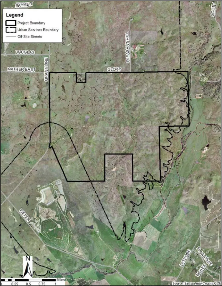
Section 613-18.2 Cordova Hills Land Use Plan Exhibit
Section titled “Section 613-18.2 Cordova Hills Land Use Plan Exhibit”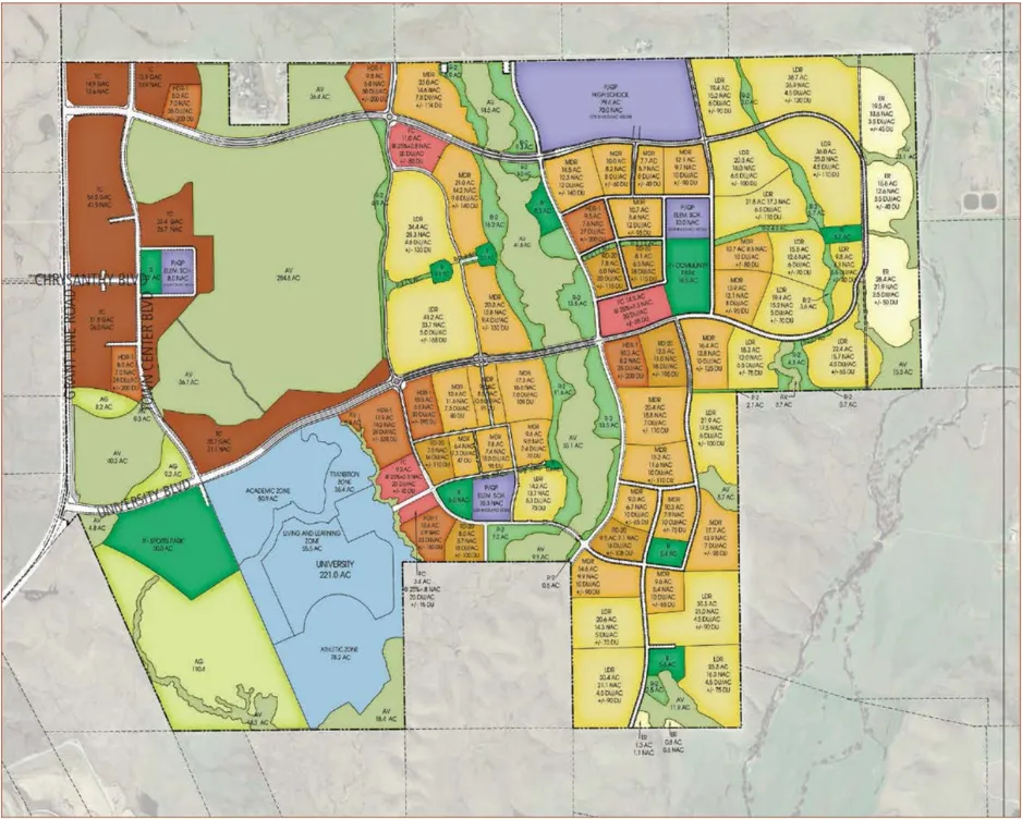
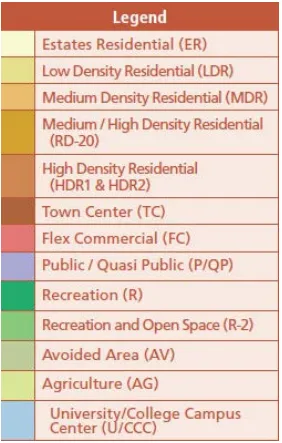
| Legend | Abbreviation |
|---|---|
| Estates | ER |
| MediumDensity Residential | MDR |
| Medium/HighDensityResidential | RD-20 |
| High DensityResidential | HDR1 & HDR2 |
| Town Center | TC |
| Public/QuasiPublic | P/QP |
| Recreation | R |
| Agriculture | AG |
| University/College Campus Center | U/CCC |
Residential Density Ranges Residential Density Ranges
Section titled “Residential Density Ranges Residential Density Ranges”| Residential Type Residential Type | Residential Density Per Acre Residential Density Per Acre |
|---|---|
| Estate Residential Estate Residential | 1-4 du/acre |
| Low Density Residential | 4-7 du/acre |
| Medium Density Residential Medium Density Residential | 7-15 du/acre |
| RD-20 | 20 du/acre |
| High Density Residential 1 | 20-30 du/acre |
| High Density Residential 2 High Density Residential 2 | 30-40 du/acre |
Section 613-18.3 Circulation Plan
Section titled “Section 613-18.3 Circulation Plan”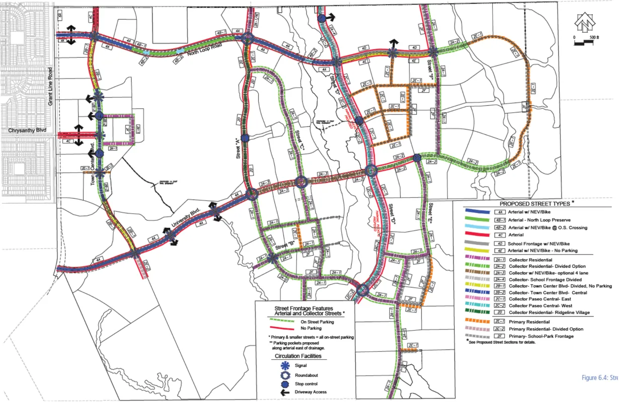
Section 613-18.4 Parks Plan
Section titled “Section 613-18.4 Parks Plan”
Section 613-18.5 Village Concept
Section titled “Section 613-18.5 Village Concept”
Section 613-18.6 Project Conditions
Section titled “Section 613-18.6 Project Conditions”These mitigation measures may be administratively amended from time to time in conjunction with any Major Amendment to the Master Plan, as described under Section 613-16, without any need to amend this Ordinance.
FINAL EIR MITIGATION MEASURES
Section titled “FINAL EIR MITIGATION MEASURES”-
The SPA shall be amended to require all lighting applications subject to the 2008 Building Efficiency Standards Section 147 to use fixtures approved by the International Dark Sky Association (Final EIR Mitigation Measure AE-1).
-
The applicant shall disclose to all prospective buyers of properties within 500 feet of the northern property boundary that they could be subject to inconvenience or discomfort resulting from accepted farming activities as per provisions of the County Right-To-Farm Ordinance and shall include a Note on all final maps disclosing the Right-To-Farm Ordinance (Final EIR Mitigation Measure AG-1).
-
The applicant shall enter into an agreement with an agricultural operator to maintain grazing use, or other more intensive use, on the land which is subject to Williamson Act contract 72-AP-109. Agricultural use shall be maintained until Williamson Act contract expiration. Documentation of this agreement shall be submitted to the Environmental Coordinator prior to approval of the zoning agreement for the Williamson Act contracted property (Final EIR Mitigation Measure AG-2) .
-
Prior to the approval of improvement plans, building permits, or recordation of the final map, whichever occurs first, the applicant shall offset the loss of 8.6 acres of Unique Farmland and 242.4 acres of Grazing Land through 1:1 preservation of farmland within a permanent conservation easement. Preservation land must be in-kind or of similar resource value (Final EIR Mitigation Measure AG-3).
-
The following language shall be added to the SPA: All individual development projects shall implement Sacramento Metropolitan Air Quality Management District rules and mitigation pertinent to construction-related ozone precursor emissions, as defined by the most current version of the Sacramento Metropolitan Air Quality Management District Guide to Air Quality Assessment (Final EIR Mitigation Measure AQ-1).
-
Comply with the provisions of the Air Quality Management Plan dated June 1, 2011, as updated March 2012 (errata) and as amended January 2013, and incorporate the requirements of this plan into the Cordova Hills Special Planning Area conditions. Also the following text shall be added to the Cordova Hills SPA: ‘All amendments to the Cordova Hills SPA with the potential to result in a change in ozone precursor emissions shall include an analysis which quantifies, to the extent practicable, the effect of the proposed SPA amendment on ozone precursor emissions. The amendment shall not increase total ozone precursor emissions above what was considered in the AQMP for the entire Cordova Hills project and shall achieve the original 35% reduction in total overall project emissions. If the amendment would require a change in the AQMP to meet that requirement, then the proponent of the SPA amendment shall consult with SMAQMD on the revised analysis and shall prepare a revised AQMP for approval by the County, in consultation with SMAQMD (Final EIR Mitigation Measure AQ-2).
-
The following language shall be added to the SPA: Buffers shall be established on a project-by-project basis and incorporated during permit or project review to provide for buffer separations between sensitive land uses and sources of air pollution or odor. The California Air Resources Board’s ‘Air Quality and Land Use Handbook: A Community Health Perspective’, or more current document, shall be utilized when establishing these buffers. Sensitive uses include schools, daycare facilities, congregate care facilities, hospitals, or other places of long-term residency for people (this includes both single- and multiple-family). The buffers shall be applied to the source of air pollution or odor, and shall be established based either on proximity to existing sensitive uses or proximity to the property boundary of land designated for sensitive uses. Buffers current at the time of the establishment of this SPA indicate that sensitive uses should be:
- A least 500 feet from auto body repair services.
- At least 50 feet from existing gasoline dispensing stations with an annual throughput of less than 3.6 million gallons and 300 feet from existing gasoline dispensing stations with an annual throughput at or above 3.6 million gallons.
- At least 300 feet from existing land uses that use methylene chloride or other solvents identified as a TAC, including furniture manufacturing and repair services (Final EIR Mitigation Measure AQ-3).
-
Include in the SPA a requirement that the western perimeter of the Sports Park and University/College Campus Center (where these are within 2,000 feet of the Kiefer landfill) include a minimum 25-foot-wide landscaping area. This landscaping area shall include a dense mix of trees and shrubs, to screen the uses from the landfill. Acceptable tree species include those expected to reach minimum heights of 40 feet (Final EIR Mitigation Measure AQ-4).
-
To compensate for the permanent loss of wetlands, the applicant shall perform one or a combination of the following prior to issuance of building permits, and shall also obtain all applicable permits from the Army Corps of Engineers, the U.S. Fish and Wildlife Service, the Central Valley Regional Water Quality Control Board, and the California Department of Fish and Game:
- Where a Section 404 Permit has been issued by the Army Corps of Engineers, or an application has been made to obtain a Section 404 Permit, the Mitigation and Management Plan required by that permit or proposed to satisfy the requirements of the Corps for granting a permit may be submitted for purposes of achieving a no netloss of wetlands. The required Plan shall be submitted to the Sacramento County Environmental Coordinator, U.S. Army Corps of Engineers, and U.S. Fish and Wildlife Service for approval prior to its implementation.
- If regulatory permitting processes result in less than a 1:1 compensation ratio for loss of wetlands, the Project applicant shall demonstrate that the wetlands which went unmitigated/uncompensated as a result of permitting have been mitigated through other means. Acceptable methods include payment into a mitigation bank or protection of off-site wetlands through the establishment of a permanent conservation easement, subject to the approval of the Environmental Coordinator.
- The Project applicant may participate in the South Sacramento Habitat Conservation Plan if it is adopted, and if the Project area and activities are covered. The applicant shall prepare Project plans in accordance with that Plan and any and all fees or land dedications shall be completed prior to construction (Final EIR Mitigation Measure BR-1 ).
-
Prior to issuance of building permits, all areas designated within the SPA as Avoided shall be placed within a permanent conservation easement, which shall be reviewed and approved by the Environmental Coordinator. At a minimum, the permanent conservation easements must cover all areas which are required to be preserved as part of the Section 404 and Section 401 wetland permits (Final EIR Mitigation Measure BR-2).
-
If construction, grading, or Project-related improvements are to occur between March 1 and September 15, a focused tree survey for tree-or-ground nesting raptors within 500 feet of the construction site (1/2-mile for Swainson’s hawk) and for ground-nesting grasshopper sparrow shall be conducted by a qualified biologist within 14 days prior to the start of construction work (including clearing and grubbing). If active nests are found, the California Department of Fish and Game shall be contacted to determine appropriate protective measures. If no active nests are found during the focused survey, no further mitigation will be required (Final EIR Mitigation Measure BR-3).
-
Prior to the approval of improvement plans, building permits, or recordation of the final map, whichever occurs first, implement one of the options below to mitigate for the loss of Swainson’s hawk foraging habitat on the Project site; based on current Project designs this is 2,267 acres. Based on current designs, this can be reduced to 2,231 acres of mitigation if the applicant establishes a permanent conservation easement over the areas designated Agriculture on the eastern and southeastern sides of the site (these are areas outside of the Urban Services Boundary). Foraging habitat preserved shall consist of grassland or similar habitat open habitat, not cropland, because this mitigation measure also offsets impacts to other species that do not use cropland habitat.
- The project proponent shall utilize one or more of the mitigation options (land dedication and/or fee payment) established in Sacramento County's Swainson's Hawk Impact Mitigation Program (Chapter 16.130 of the Sacramento County Code).
- The Project proponent shall, to the satisfaction of the California Department of Fish and Game, prepare and implement a Swainson's hawk mitigation plan that will include preservation of Swainson's hawk foraging habitat.
- Should the County Board of Supervisors adopt a new Swainson's hawk mitigation policy/program (which may include a mitigation fee payable prior to issuance of building permits) prior to the implementation of one of the measures above, the Project proponent may be subject to that program instead.
-
Prior to construction activity (including site improvements, and building construction) focused surveys shall be conducted by a qualified biologist for burrowing owls in the construction area and within 500 feet of the construction area. Surveys shall be conducted no less than 14 days and no more than 30 days prior to commencement of construction activities. Surveys shall be conducted in accordance with ‘Burrowing Owl Survey Protocol and Mitigation Guidelines’ published by The California Burrowing Owl Consortium (April 1993). The following shall also apply:
- If no occupied burrows are found in the survey area, a letter report documenting survey methods and findings shall be submitted to the County and no further mitigation is necessary.
- If an occupied burrow is found the applicant shall contact the Environmental Coordinator and consult with the California Department of Fish (CDFG), prior to construction, to determine if avoidance is possible or if burrow relocation will be required.
- If owls are to remain on-site, a minimum of 6.5 acres of foraging habitat for each occupied burrow needs to be permanently preserved according to California Department of Fish and Game guidelines. In addition, no activity shall take place within 160 feet of an active burrow from September 1 to January 31 (wintering season) or 250 feet from February 1 through August 31 (breeding season). Protective fencing shall be placed, at the distances above, around the active burrows and no activity shall occur within the protected buffer areas. Permanent improvements shall be a minimum of 250 feet from an occupied burrow.
- Any impact to active owl burrows, relocation of owls, or mitigation for habitat loss shall be done in accordance with the Fish and Game 'Staff Report on Burrowing Owl Mitigation' (October 17, 1995) or the version current at the time of construction. Written evidence from Fish and Game staff shall be provided to the Environmental Coordinator attesting to the permission to remove burrows, relocate owls, or mitigate for lost habitat, and shall include a plan to monitor mitigation success (Final EIR Mitigation Measure BR-5)
-
If construction occurs between March 1 and July 31 pre-construction surveys for nesting tricolored blackbirds shall be performed by a qualified biologist. Surveys shall include the construction site and areas of appropriate habitat within 300 feet of the construction site. The survey shall occur no longer than 14 days prior to the start of construction work (including clearing, grubbing or grading). The biologist shall supply a brief written report (including date, time of survey, survey method, name of surveyor and survey results) to the Environmental Coordinator prior to ground disturbing activity. If no tricolored blackbird were found during the pre-construction survey, no further mitigation would be required. If an active tricolored blackbird colony is found on-site or within 300 feet of the construction site the project proponent shall do the following:
- Consult with the California Department of Fish and Game to determine if project activity will impact the tricolored blackbird colony(s), and implement appropriate avoidance and impact minimization measures if so directed. Provide the Environmental Coordinator with written evidence of the consultation or a contact name and number from the California Department of Fish and Game.
- The applicant may avoid impacts to tricolored blackbird by establishing a 300-foot temporary setback with fencing that prevents any project activity within 300 feet of the colony. A qualified biologist shall verify that setbacks and fencing are adequate and will determine when the colonies are no longer dependent on the nesting habitat (i.e. nestlings have fledged and are no longer using habitat), which will determine when the fencing may be removed. The breeding season typically ends in July (Final EIR Mitigation Measure BR-6)
-
Presence of California linderiella, midvalley fairy shrimp, vernal pool fairy shrimp and vernal pool tadpole shrimp shall be assumed unless determinate surveys that comply with U.S. Fish and Wildlife protocol conclude that the species are absent. If the protocol surveys are performed and all listed crustacean species are absent, Ricksecker’s water scavenger beetle may also be presumed absent, and no further mitigation shall be required for listed vernal pool invertebrates. If species are found, one or a combination of the following shall apply:
- Total Avoidance: Species are present or assumed to be present. Unless a smaller buffer is approved through formal consultation with the Fish and Wildlife Service, construction fencing shall be installed a minimum of 250 feet from all delineated vernal pool margins. All construction activities are prohibited within this buffer area. For all vernal pools where total avoidance is achieved, no further action is required.
- Compensate for habitat removed. Obtain all applicable permits from the U.S. Fish and Wildlife Service, U.S. Army Corps of Engineers, California Department of Fish and Game, and the Central Valley Regional Water Quality Control Board for any proposed modifications to vernal pools and mitigate for habitat loss in accordance with the Biological Opinion and Section 404 permits obtained for the Project. At a minimum, mitigation ratios shall be consistent with County General Plan Policy, which requires no net loss of wetland resources. Any vernal pool loss not mitigated through the permitting process shall be mitigated for by payment into a mitigation bank or protection of off-site wetlands through the establishment of a permanent conservation easement, subject to the approval of the Environmental Coordinator (Final EIR Mitigation Measure BR-7).
-
If construction activities encroach within the 250-foot buffer for vernal pools 358, 363, 370, 426 or 511 the applicant shall prepare a pesticide and pollution prevention plan. The plan shall include measures to reduce pollution run-off, pesticide drift, and other similar potential contaminates, to protect surrounding preserve areas from urban contaminates. Measures shall include the implementation of best management practices (e.g. straw wattles, silt fencing, and soil stabilization) for stormwater control. The plan shall be incorporated in the Operations and Management Plan which is a requirement of the Section 404 permit process (Final EIR Mitigation Measure BR-8).
-
The project applicant shall prepare an invasive species removal and prevention plan. The plan shall provide methods to remove invasive species from preservation areas and to restore the affected wetland features. The plan shall include methods for the prevention of the introduction of new invasive species from landscapes associated with the development. Minimum components of such a plan shall include: mapping of existing invasive plant populations within the avoided areas, with the map being updated a minimum of every five years; a description of acceptable methods for removing invasive species, examples of which include hand removal or biological controls (e.g. natural parasites); and a prohibition on the use of non-native plants within either the avoided areas or the Recreation-2 areas. The plan shall be incorporated in the Operations and Management Plan which is a requirement of the Section 404 permit process (Final EIR Mitigation Measure BR-9)
-
The following text shall be added to the Cordova Hills SPA: All amendments to the SPA with the potential to change SPA-wide GHG emissions shall include an analysis which quantifies, to the extent practicable, the effect of the Amendment on SPA-wide greenhouse gas emissions. The Amendment shall not increase SPA-wide greenhouse gas emissions above an average 5.80 metric tons per capita (including emissions from building energy usage and vehicles). If the SPA amendment would require a change in the approved GHG Reduction Plan in order to meet the 5.80 MT CO2e threshold, then the proponent of the SPA amendment shall consult with the SMAQMD on the revised analysis and shall prepare a revised GHG Reduction Plan for approval by the County, in consultation with SMAQMD. (Final EIR Mitigation Measure CC-1).
- Prior to the recordation of a final map or issuance of a building permit, whichever comes first, the applicant will submit a comprehensive 'Trail and Wayfinding Signage Master Plan' for the Cordova Hills project site for review and approval by the Office of Planning and Environmental Review, County Department of Transportation, County Engineering, and Sacramento Metropolitan Air Quality Management District. The 'Trail and Wayfinding Signage Master Plan' will focus on guiding visitors and residents to schools, parks, employment, retail, and other destinations within and surrounding the project site in order to encourage alternative modes of travel, both utilitarian and recreational. The 'Trail and Wayfinding Signage Master Plan' will define: 1) the hierarchy and design of signage for different trails, 2) the location of the wayfinding signage nodes, 3) the design of durable trail maps, directional arrows with destinations and distances, and street names at trail exits, and 4) the timing of implementation of construction of the signage, including possible updates to the signage, as the project is built-out in phases.
- Prior to the approval of improvement plans or building permits, whichever occurs first, the applicant will submit 'Wayfinding Signage Plan Sheet(s)' that will identify the subject trails, wayfinding signage nodes, location of directional signs, and the design and construction details within the proposed subdivision or commercial development.
-
If subsurface deposits believed to be cultural or human in origin are discovered during construction, then all work must halt within a 200-foot radius of the discovery. A qualified professional archaeologist, meeting the Secretary of the Interior’s Professional Qualification Standards for prehistoric and historic archaeology, shall be retained at the Applicant’s expense to evaluate the significance of the find. If it is determined due to the types of deposits discovered that a Native American monitor is required, the Guidelines for Monitors/Consultants of Native American Cultural, Religious, and Burial Sites as established by the Native American Heritage Commission shall be followed, and the monitor shall be retained at the Applicant’s expense.
Work cannot continue within the 200-foot radius of the discovery site until the archaeologist conducts sufficient research and data collection to make a determination that the resource is either 1) not cultural in origin; or 2) not potentially eligible for listing on the National Register of Historic Places or California Register of Historical Resources.
If a potentially-eligible resource is encountered, then the archaeologist, Environmental Coordinator, and project proponent shall arrange for either 1) total avoidance of the resource, if possible; or 2) test excavations or total data recovery as mitigation. The determination shall be formally documented in writing and submitted to the Environmental Coordinator as verification that the provisions of CEQA for managing unanticipated discoveries have been met.
In addition, pursuant to Section 5097.97 of the State Public Resources Code and Section 7050.5 of the State Health and Safety Code, in the event of the discovery of human remains, all work is to stop and the County Coroner shall be immediately notified. If the remains are determined to be Native American, guidelines of the Native American Heritage Commission shall be adhered to in the treatment and disposition of the remains (Final EIR Mitigation Measure CR-1).
-
Any structure within the project boundaries (including but not limited to, buildings, subsurface vaults, utilities, or any other areas where potential landfill gas buildup may cause adverse impacts to the public health or safety or the environment) within 1,000 feet of buried waste or proposed buried waste at Kiefer Landfill (refer to Plate HM-2 of the EIR) shall be continuously monitored by the owner/operator of said structure for landfill gas and be designed and constructed to prevent landfill gas accumulation in those structures (Final EIR Mitigation Measure HM-1).
-
The location and nature of the Sacramento County Boys Ranch facility shall be disclosed to all prospective buyers of estate-residential properties (Final EIR Mitigation Measure LU1).
-
The location and nature of the Kiefer Landfill facility shall be disclosed to all prospective buyers of properties within one mile of the ultimate active landfill boundary. The disclosure notice shall include:
- A statement substantially consistent with the following: 'The landfill will expand in height and land area over time, and thus the visibility and proximity of the landfill from the property at the time of purchase does not reflect how visible or proximate the landfill will be in the future.' This statement shall be supplemented with relevant facts about ultimate landfill design, including the distance of the property to the ultimate planned edge of the landfill waste disposal area to the nearest 100 feet and the ultimate planned height of the landfill (as set forth in the Solid Waste Facilities Permit).
- Notification that the landfill operates under a Solid Waste Facilities Permit and is required to control pests, vectors, litter, and odor to the extent practicable, but that it is not possible to eliminate all of these nuisances. For this reason, property owners may experience some of these nuisance conditions.
- Notification that the active landfill area is lighted at night. (Final EIR Mitigation Measure LU-2).
-
All residential development projects exposed to greater than 65 dB Ldn (as identified in Appendix NO-1) at the property line shall be designed and constructed to reduce noise levels to within General Plan Noise Element standards for exterior activity areas. Potential options for achieving compliance with noise standards include, but are not limited to, noise barriers, increased setbacks, and/or strategic placement of structures. An acoustical analysis substantiating the required noise level reduction, prepared by a qualified acoustical consultant shall be submitted to and verified by the Environmental Coordinator prior to the issuance of any building permits for affected sites (Final EIR Mitigation Measure NO-1).
-
All residential development projects exposed to greater than 70 dB Ldn (as identified in Appendix NO-1) at the property line shall be designed and constructed to achieve an interior noise level of 45 dB Ldn or less. Potential options for achieving compliance with noise standards include, but are not limited to, noise barriers, increased setbacks, strategic placement of structures and/or enhanced building construction techniques. An acoustical analysis substantiating the required noise level reduction, prepared by a qualified acoustical consultant, shall be submitted to and verified by the Environmental Coordinator prior to the issuance of any building permits for the site (Final EIR Mitigation Measure NO-2).
-
Non-residential development projects such as churches, libraries, meeting halls, and schools exposed to greater than 60 dB Ldn, and all non-residential development projects such as transient lodging, hospitals and nursing homes, and office buildings exposed to greater than 65 dB Ldn (as identified in Appendix NO-1) at the property line shall demonstrate that interior noise volumes will not exceed General Plan Noise Element standards for non-residential uses exposed to traffic noise. This may be accomplished by providing documentation that the type of use is within acceptable limits based on the location of the identified noise contours and assuming standard exterior-to-interior attenuation of 25 dB. If this cannot be demonstrated, an acoustical analysis substantiating the required noise level reduction, prepared by a qualified acoustical consultant, shall be submitted to and verified by the Environmental Coordinator prior to the issuance of any building permits for affected sites. Potential options for achieving compliance with noise standards include, but are not limited to, noise barriers, increased setbacks, strategic placement of structures and/or enhanced building construction techniques. The measure does not apply to commercial uses (Final EIR Mitigation Measure NO-3).
-
All parks exposed to noise volumes in excess of 70 dB (as identified in Appendix NO-1) at the property line shall be designed and constructed to reduce noise levels within park activity areas (benches, play structures, etc.) to within General Plan Noise Element standards for parks. Potential options for achieving compliance with noise standards include, but are not limited to, noise barriers, increased setbacks, and/or strategic placement of structures. For barrier and other structural options, an acoustical analysis substantiating the required noise level reduction, prepared by a qualified acoustical consultant shall be submitted to and verified by the Environmental Coordinator prior to the issuance of any building permits for affected sites (Final EIR Mitigation Measure NO-4).
-
All non-residential development projects located adjacent to residentially designated properties shall be designed and constructed to ensure that noise levels generated by the uses do not result in General Plan Noise Element standards being exceeded on adjacent properties. An acoustical analysis substantiating the required noise level reduction, prepared by a qualified acoustical consultant shall be submitted to and verified by the
Environmental Coordinator prior to the issuance of any building permits for the nonresidential projects with the potential to generate substantial noise (e.g. car wash, auto repair, or buildings with heavy-duty truck loading docks) if those uses are adjacent to residentially designated properties. The acoustical analysis shall include, but not be limited to, consideration of potential noise conflicts due to operation of the following items:
- Outdoor playing fields;
- Mechanical building equipment, including HVAC systems;
- Loading docks and associated truck routes;
- Refuse pick up locations; and
- Refuse or recycling compactor units (Final EIR Mitigation Measure NO-5).
-
The following conditions will be required to ensure adequate disclosure of Mather Airport operations:
- Notification in the Public Report prepared by the California Department of Real Estate shall be provided disclosing to prospective buyers that the parcel is located within the applicable Airport Planning Policy Area and that aircraft operations can be expected to overfly that area at varying altitudes less than 3,000 feet above ground level.
- Avigation Easements prepared by the Sacramento County Counsel's Office shall be executed and recorded with the Sacramento County Recorder on each individual residential parcel contemplated in the development in favor of the County of Sacramento. All Avigation Easements recorded pursuant to this policy shall, once recorded, be copied to the director of Airports and shall acknowledge the property location within the appropriate Airport Planning Policy Area and shall grant the right of flight and unobstructed passage of all aircraft into and out of the appropriate airport (Final EIR Mitigation Measure NO-6).
-
The applicant shall construct or fund, as set forth in the phasing and financing plan approved by the Sacramento County Department of Transportation, the below mitigation measures. The phasing and financing plan shall ensure commencement of construction of traffic improvements prior to degradation of LOS below applicable County standards. This mitigation recognizes that should any of the measures below benefit other projects, a reimbursement agreement and/or a fee credit to the applicant may be considered.
- Bradshaw Road and Jackson Road - Provide a second westbound through lane.
- Eagles Nest Road and Jackson Road - Construct a new traffic signal. Provide a left turn lane and a through-right turn shared lane on the northbound and southbound approaches.
- Grant Line Road and Sunrise Boulevard - Provide a separate southbound right turn lane so the southbound approach has one left turn lane, one through lane and one right turn lane.
- Grant Line Road and White Rock Road - Modify the intersection and traffic signal to provide dual left turn lanes and two through lanes on the northbound approach; provide two through lanes and a separate right turn lane on the southbound approach; and provide two left turn lanes and a separate right turn lane on the eastbound approach. On the western leg of the intersection, two westbound departure lanes are required.
- School Access and North Loop Road - Provide dual eastbound left turn lanes. The applicant shall be responsible for a focused access study addressing the internal circulation of the Cordova Hills project to finalize the design of intersection geometries and length of left turn pockets. The scope of work for the analysis shall be submitted to the Sacramento County DOT staff. Upon completion, the analysis shall be submitted to the Sacramento County DOT for approval and recommendations (Final EIR Mitigation Measure TR-1).
-
The applicant shall construct or fund, as set forth in the phasing and financing plan approved by the Sacramento County Department of Transportation, and in consultation with the City of Rancho Cordova, the below mitigation measures. The phasing and financing plan shall ensure commencement of construction of traffic improvements prior to degradation of LOS below the applicable County or City standards. This mitigation recognizes that should any of the measures below benefit other projects, a reimbursement agreement may be considered.
- Zinfandel Drive and White Rock Road - The applicant shall be responsible for a fair share of this measure. Provide separate dual right turns on the westbound approach so the westbound approach has two left turn lanes, two through lanes and two right turn lanes. The fair share shall be calculated to the satisfaction of Sacramento County Department of Transportation and may be up to 100% of the cost of the improvements.
- Sunrise Boulevard and White Rock Road - Provide overlap phasing on the eastbound and westbound approaches.
- Sunrise Boulevard and Douglas Road - Provide overlap phasing on the westbound approach.
- Sunrise Boulevard and Jackson Road - Provide an eastbound through lane, an eastbound through-right turn shared lane, and an eastbound left turn lane; a northbound left turn lane, two northbound through lanes, and a right turn lane; one westbound through lane, a westbound right turn lane, and a westbound left turn lane; a southbound through lane, a southbound left turn lane, and a southbound right turn lane.
- Grant Line Road and Jackson Road - The applicant shall be responsible for a fair share of this measure. Provide a left turn lane and a through-right shared turn lane on the eastbound and westbound approaches. Provide a separate left turn lane, a through lane and a separate right turn lane on the northbound and southbound approaches. The fair share shall be calculated to the satisfaction of Sacramento County Department of Transportation and may be up to 100% of the cost of the improvements.
- Grant Line Road and Kiefer Boulevard - Construct a new traffic signal. Provide a left turn lane, a through lane and a through-right turn shared lane on the northbound and southbound approaches; provide a left turn lane and a through-right turn shared lane on the eastbound and westbound approaches.
- Grant Line Road and Douglas Road - Construct a new traffic signal. Provide dual left turn lanes and a separate through lane on the northbound, a through lane and a through-right turn shared lane on the southbound approach, and a separate left turn lane and a free-right turn lane on the eastbound approach. Also an extra southbound departure lane is needed for the eastbound free-right movement. To be consistent with the segment mitigations a second northbound through lane is included.
- Grant Line Road and North Loop Road - Construct a new traffic signal. Provide two through lanes and a separate right turn lane on the northbound approach, dual left turn lanes and one through on the southbound approach, and one left turn lane and one free-right turn lane on the westbound approach. Also an extra northbound departure lane is needed for the westbound free-right movement. To be consistent with the segment mitigations a second southbound through lane is included.
- Grant Line Road and Chrysanthy Boulevard - Construct a new traffic signal. Provide a through lane and a separate right turn lane on the northbound approach, dual left turn lanes and a through lane on the southbound approach, and dual left turn lanes and one right turn lane on the westbound approach. To be consistent with the segment mitigations a second northbound and southbound through lane is included. Also provide two westbound through lanes for when Chrysanthy Boulevard is connected through Rancho Cordova.
- Grant Line Road and University Boulevard - Construct a new traffic signal. Provide a through lane and a separate free-right turn lane on the northbound approach, dual left turn lanes and one through lanes on the southbound approach, and dual left turn lanes and a right turn lane on the westbound approach. Also an extra eastbound departure lane is needed for the northbound free-right movement. To be consistent with the segment mitigations a second northbound and southbound through lane is included (Final EIR Mitigation Measure TR-2).
-
The applicant shall construct or fund, as set forth in the phasing and financing plan approved by the Sacramento County Department of Transportation, the below mitigation measures. The phasing and financing plan shall ensure commencement of construction of traffic improvements prior to degradation of LOS below applicable County standards. This mitigation recognizes that should any of the measures below benefit other projects, a reimbursement agreement and/or a fee credit to the applicant may be considered.
- Prairie City Road from US 50 to White Rock Road - Increase roadway capacity by upgrading the capacity class for this segment from a rural highway without shoulders to a rural highway with shoulders (Final EIR Mitigation Measure TR-3).
-
The applicant shall construct or fund, as set forth in the phasing and financing plan approved by the Sacramento County Department of Transportation, and in consultation with the City of Elk Grove, the below mitigation measures. The phasing and financing plan shall ensure commencement of construction of traffic improvements prior to degradation of LOS below the applicable County or City standards. This mitigation recognizes that should any of the measures below benefit other projects, a reimbursement agreement may be considered.
- Grant Line Road from Sheldon Road to Calvine Road - Increase roadway capacity by widening this segment to 4 lanes and upgrading the capacity class to an arterial with moderate access control (Final EIR Mitigation Measure TR-4).
-
The applicant shall construct or fund, as set forth in the phasing and financing plan approved by the Sacramento County Department of Transportation, and in consultation with the City of Rancho Cordova, the below mitigation measures. The phasing and financing plan shall ensure commencement of construction of traffic improvements prior to degradation of LOS below the applicable County or City standards. This mitigation recognizes that should any of the measures below benefit other projects, a reimbursement agreement may be considered.
- Grant Line Road from Jackson Road to Kiefer Boulevard - Increase roadway capacity by widening this segment to 4 lanes and upgrading the capacity class to an arterial with moderate access control.
- Grant Line Road from Kiefer Boulevard to University Boulevard - Increase roadway capacity by widening this segment to 4 lanes and upgrading the capacity class to an arterial with moderate access control.
- Grant Line Road from University Boulevard to Chrysanthy Boulevard - Increase roadway capacity by widening this segment to 4 lanes and upgrading the capacity class to an arterial with moderate access control.
- Grant Line Road from Chrysanthy Boulevard to North Loop - Increase roadway capacity by widening this segment to 4 lanes and upgrading the capacity class to an arterial with moderate access control.
- Grant Line Road from North Loop to Douglas Road - Increase roadway capacity by widening this segment to 4 lanes and upgrading the capacity class to an arterial with moderate access control.
- Grant Line Road from Douglas Road to White Rock Road - Increase roadway capacity by widening this segment to 4 lanes and upgrading the capacity class to an arterial with moderate access control.
- Jackson Road from Sunrise Boulevard to Grant Line Road - Increase roadway capacity by widening this segment to 4 lanes and upgrading the capacity class to an arterial with moderate access control.
- Douglas Road from Rancho Cordova Parkway to Grant Line Road - Increase roadway capacity by widening this segment to 4 lanes and upgrading the capacity class to an arterial with moderate access control between Americanos Boulevard and Grant Line Road, and by adding two westbound travel lanes to Douglas between Rancho Cordova Parkway to Americanos Boulevard. Construct interim sidewalk improvements (typically a detached asphaltic concrete path) and bicycle lanes (Final EIR Mitigation Measure TR-5) .
-
The applicant shall be responsible for funding a fair share of the construction costs of the below mitigation measures. The fair share shall be calculated to the satisfaction of Sacramento County Department of Transportation, in consultation with Caltrans.
- Westbound US 50 from Hazel Avenue to Sunrise Boulevard - Add an auxiliary lane.
- Eastbound US 50 from Sunrise Boulevard to Hazel Avenue - Add an auxiliary lane (Final EIR Mitigation Measure TR-6) .
-
The applicant shall be responsible for a fair share of the below mitigation measures. The fair share shall be calculated to the satisfaction of Sacramento County Department of Transportation and may be up to 100% of the cost of the improvements.
- Construct interim sidewalks improvements (typically a detached asphaltic concrete path) and bicycle lanes along Grant Line Road from Douglas Road to White Rock Road and on Douglas Road from Rancho Cordova Parkway to Grant Line Road, to the satisfaction of the Sacramento County Department of Transportation (Final EIR Mitigation Measure TR-7) .
-
The applicant shall be responsible for a fair share of the below mitigation measures. The fair share shall be calculated to the satisfaction of Sacramento County Department of Transportation and may be up to 100% of the cost of the improvements.
- School Access and North Loop Road - Provide dual eastbound left turn lanes (Final EIR Mitigation Measure TR-8) .
-
The applicant shall be responsible for a fair share of the below mitigation measures. The fair share shall be calculated to the satisfaction of Sacramento County Department of Transportation, in consultation with the City of Rancho Cordova, and may be up to 100% of the cost of the improvements.
- Sunrise Boulevard and Douglas Road - Provide overlap phasing on the eastbound and westbound right turns.
- Grant Line Road and Douglas Road - Provide a third southbound through lane and overlap phasing on the eastbound right turn lane. To be consistent with the segment mitigations a third northbound through lane is included.
- Grant Line Road and North Loop Road - Provide a westbound free-right turn lane. Also an extra northbound departure lane is needed for the westbound free-right movement.
- Grant Line Road and University Boulevard - Provide a northbound free-right turn lane. Also an extra eastbound departure lane is needed for the northbound free-right movement (Final EIR Mitigation Measure TR-9).
-
The applicant shall be responsible for a fair share of the below mitigation measures. The fair share shall be calculated to the satisfaction of Sacramento County Department of Transportation and may be up to 100% of the cost of the improvements.
- North Loop Road from Street D to Street F - Increase roadway capacity by widening this segment to 4 lanes and upgrading the capacity class to an arterial with low access control (Final EIR Mitigation Measure TR-10) .
-
Deleted
ROADWAY IMPROVEMENT TRIGGERS (DEPARTMENT OF TRANSPORTATION)
Section titled “ROADWAY IMPROVEMENT TRIGGERS (DEPARTMENT OF TRANSPORTATION)”Roadway Improvements
Section titled “Roadway Improvements”The County Department of Transportation conditions below are based on traffic mitigation measures identified in the Final Environmental Impact Report (FEIR) for the Cordova Hills SPA and on additional traffic analysis to determine the appropriate phasing of roadway improvements associated with development of approved land uses in the Cordova Hills SPA. For a complete description of the mitigation measure improvements, refer to the Cordova Hills SPA FEIR. These conditions apply to all development within the Cordova Hills area and are in addition to any other conditions applied to individual properties within the Cordova Hills SPA.
Conditions of approval may call for partial roadway improvements or the expansion of existing facilities. The County recognizes and allows partial phased improvements. Fee credits or reimbursements for partially constructed, or phased, roadway facilities will be adjusted, at the County’s discretion, according to the portion of the cost incurred for permanent improvements eligible for credit or reimbursement under the applicable fee program. The partially phased interim improvements that are not the ultimate facility or are not at the ultimate location are considered a ‘throw away’ item. The costs associated with ‘throw away’ items of the partially phased improvements are non-reimbursable through the SCTDF program.
It is recognized that circumstances may change over time and in cases where the developer of the Cordova Hills Project is obligated to construct or is constructing an item of roadway infrastructure pursuant to any of the below conditions, the County may request that Developer construct an additional item of infrastructure. Developer may construct such additional infrastructure provided County reimburses the Developer for all additional costs that are incurred by Developer to construct the requested additional infrastructure.
Fair Share Funding/Mitigation Measure: Trigger Adjustments
Section titled “Fair Share Funding/Mitigation Measure: Trigger Adjustments”- Fair Share Funding/Mitigation Measure: Trigger Adjustments. The developer of the Cordova Hills Project or its successors, at their own expense, may submit an additional traffic analysis along with a request for an adjustment of their fair share funding and/or the improvement trigger requirement for any roadway infrastructure mitigation measures required below. The Director of the County’s Department of Transportation may adjust the fair share funding percentage and/or the improvement trigger in his discretion based on the traffic analysis as long as the required level of service is achieved. Whenever the County enters into a reciprocal funding agreement to address cross jurisdictional roadway impacts with an adjacent jurisdiction, the Cordova Hills Project’s fair share funding obligation and/or the mitigation measure trigger for such cross jurisdictional roadway impacts shall be adjusted by the County to take into account other new development projects which have cross jurisdictional roadway impacts and an obligation to build or contribute to the cost to build the roadway improvement in question.
Onsite Roadway Improvement Conditions to be constructed by the developer of the Cordova Hills Project:
Section titled “Onsite Roadway Improvement Conditions to be constructed by the developer of the Cordova Hills Project:”-
As part of intersection improvements, provide dual eastbound left turn lanes at the intersection of North Loop Road and the proposed school access pursuant to the Sacramento County Improvement Standards and to the satisfaction of the Department of Transportation. (FEIR Mitigation Measures TR-1.G and TR-8.A)
-
On site roadways within the Cordova Hills Project area shall be subject to the requirements of the County policy concerning discontinuous roadway frontage improvements (‘sawtooth’). Unless otherwise noted, a specific project subject to these requirements shall install roadway frontage improvements along logical segments of at least one-quarter mile in length, including the specific project’s frontage. If the length of the specific project’s conditioned on-site frontage improvements on a single roadway is equal to or greater than one-quarter mile in length, then the specific project will be deemed to have satisfied the logical segment condition for that roadway. If the specific project’s on-site frontage improvements are less than one-quarter mile, the specific project shall install additional off site frontage improvements within the Cordova Hills SPA in order to satisfy the logical segment condition. The location of limits of such on-site frontage improvements will be determined at the time of improvement plan approval and to the satisfaction of the Department of Transportation. On-site frontage improvements shall include the construction of the outside travel lane, bike lane or NEV lane, finished roadway edge, and a pedestrian walkway, all as per applicable SPA cross section. Specific projects that front on more than one of the roadways listed in Table A-1 (including corner lots) shall be responsible for meeting the logical segment condition on each fronting roadway.
Table A-1 Cordova Hills Special Planning Area - Roadways Subject to Logical Segments:
- University Boulevard
- Chrysanthy Boulevard
- North Loop Road
- Town Center Boulevard
- Street ‘A’
- Street ‘D’
Roadway Improvement Conditions at time of connection to Grant Line Road. Improvements on Grant Line Road shall be coordinated with the County Department of Transportation and the Capital Southeast Connector Joint Powers Authority (Connector JPA). The nature and extent of the following improvements will depend on the timing of the improvements on Grant Line Road necessary to provide appropriate access to Cordova Hills and the timing of Connector improvements along this common segment of Grant Line Road, a future Connector Expressway segment. In order not to impede or delay the development of the Cordova Hills Project, Cordova Hills may install interim improvements, provided that to the extent feasible; throw away improvements are minimized, improvements are compatible with the most recently adopted Connector Project Design Guidelines (Connector PDG), and consultation with the Connector JPA occurs. Depending on the timing of construction of Connector JPA improvements that will fully mitigate for specific Cordova Hill’s impact, at the request of Cordova Hills and upon approval by the County Department of Transportation and the County Environmental Coordinator and with consultation with the Connector JPA, a Cordova Hills cash in-lieu of improvements directed to the Connector JPA and for the express use of funding those improvements that mitigate for the Cordova Hills impact shall be considered as equivalent improvements. If a finding of equivalency is made, such an in-lieu payment shall fully satisfy Cordova Hills’ mitigation obligations as established by the EIR and the Conditions of Approval. Applicable to conditions of approval number 43 through 45.
- At the time of connection of North Loop Road to Grant Line Road, install a stop sign on the westbound approach with one left turn lane, one right turn lane, and a 14-foot wide refuge lane for a length of 200 feet for the westbound to southbound movement; on the southbound approach (uncontrolled), install a left turn lane and a through lane; and on the northbound approach (uncontrolled), install a shared through-right turn lane to the satisfaction of the Department of Transportation, provided that the County and the City of Rancho Cordova have reached agreement for construction of the portion of the improvements within the City’s jurisdiction. Performance of this condition shall be held in abeyance pending such agreement and development may continue. Note: pursuant to Title 22 of the Sacramento County Code, developments greater than 40 units shall be served by two points of public access and the streets must be greater than 50 feet in width for 20 or more units.
- At the time of connection of Chrysanthy Boulevard to Grant Line Road, install a stop sign on the westbound approach with one left turn lane, one right turn lane, and a 14-foot wide refuge lane for a length of 200 feet for the westbound to southbound movement; on the southbound approach (uncontrolled), install a left turn lane and a through lane; and on the northbound approach (uncontrolled), install a shared through-right turn lane to the satisfaction of the Department of Transportation, provided that the County and the City of Rancho Cordova have reached agreement for construction of the portion of the improvements within the City’s jurisdiction. Performance of this condition shall be held in abeyance pending such agreement and development may continue. Note: pursuant to Title 22 of the Sacramento County Code, developments greater than 40 units shall be served by two points of public access and the streets must be greater than 50 feet in width for 20 or more units.
- At the time of connection of University Boulevard to Grant Line Road, install a stop sign on the westbound approach with one left turn lane, one right turn lane, and a 14-foot wide refuge lane for a length of 200 feet for the westbound to southbound movement; on the southbound approach (uncontrolled), install a left turn lane and a through lane; and on the northbound approach (uncontrolled), install a shared through-right turn lane to the satisfaction of the Department of Transportation, provided that the County and the City of Rancho Cordova have reached agreement for construction of the portion of the improvements within the City’s jurisdiction. Performance of this condition shall be held in abeyance pending such agreement and development may continue. Note: pursuant to Title 22 of the Sacramento County Code, developments greater than 40 units shall be served by two points of public access and the streets must be greater than 50 feet in width for 20 or more units.
Roadway Improvement Trigger Conditions for Project Access to Grant Line Road. Improvements on Grant Line Road shall be coordinated with the County Department of Transportation and the Capital Southeast Connector Joint Powers Authority (Connector JPA). The nature and extent of the following improvements will depend on the timing of the improvements on Grant Line Road necessary to provide appropriate access to Cordova Hills and the timing of Connector improvements along this common segment of Grant Line Road, a future Connector Expressway segment. In order not to impede or delay the development of the Cordova Hills Project, Cordova Hills may install interim improvements; provided that to the extent feasible, throw away improvements are minimized, improvements are compatible with the most recently adopted Connector Project Design Guidelines (Connector PDG), and consultation with the Connector JPA occurs. Depending on the timing of construction of Connector JPA improvements that will fully mitigate for specific Cordova Hill’s impact, at the request of Cordova Hills and upon approval by the County Department of Transportation and the County Environmental Coordinator and with consultation with the Connector JPA, a Cordova Hills cash in-lieu of improvements directed to the Connector JPA and for the express use of funding those improvements that mitigate for the Cordova Hills impact shall be considered as equivalent improvements. If a finding of equivalency is made, such an in-lieu payment shall fully satisfy Cordova Hills’ mitigation obligations as established by the EIR and the Conditions of Approval. Applicable to conditions of approval number 46 through 52.
Prior to the recordation of the final maps for residential land uses or issuance of building permits for non-residential land uses (including the University) for 1,250 Dwelling Unit Equivalents (DUEs) within the Cordova Hills SPA :
- Commence reconstruction and widening of the intersection of North Loop Road and Grant Line Road pursuant to the Sacramento County Improvement Standards and to the satisfaction of the Department of Transportation, provided that the County and the City of Rancho Cordova have reached agreement for construction of the portion of the improvements within the City’s jurisdiction. Performance of this condition shall be held in abeyance pending such agreement and development may continue. Improvements shall include the installation of a traffic signal, providing a u-turn lane and shared through-right turn lane on the northbound approach; two left turn lanes and a through lane on the southbound approach; and a left turn lane and a right turn lane on the westbound approach. Bus turnouts will be required on Grant Line Road and North Loop Road.
- Commence reconstruction and widening of the intersection of University Boulevard and Grant Line Road pursuant to the Sacramento County Improvement Standards and to the satisfaction of the Department of Transportation, provided that the County and the City of Rancho Cordova have reached agreement for construction of the portion of the improvements within the City’s jurisdiction. Performance of this condition shall be held in abeyance pending such agreement and development may continue. Improvements shall include the installation of a traffic signal, providing a u-turn lane and a through lane, and a right turn lane on the northbound approach; one left turn lane and one through lane on the southbound approach; and dual left turn lanes and a right turn lane on the westbound approach. Bus turnouts will be required on Grant Line Road and University Boulevard.
Prior to the recordation of the final maps for residential land uses or issuance of building permits for non-residential land uses (including the University) for 1,800 DUEs within the Cordova Hills SPA :
- Commence reconstruction and widening of the intersection of North Loop Road and Grant Line Road pursuant to the Sacramento County Improvement Standards and to the satisfaction of the Department of Transportation, provided that the County and the City of Rancho Cordova have reached agreement for construction of the portion of the improvements within the City’s jurisdiction. Performance of this condition shall be held in abeyance pending such agreement and development may continue. Improvements shall include a modification to the traffic signal, providing a u-turn lane and two through lanes, and a right turn lane on the northbound approach; two left turn lanes and two through lanes on the southbound approach; and two left turn lanes and a free right turn lane on the westbound approach. For the free-right turn movement, provide sufficient acceleration lane and taper length and grant the right of direct vehicular access to the County of Sacramento along the acceleration lane/taper length to the satisfaction of the Department of Transportation.
Prior to the recordation of the final maps for residential land uses or issuance of building permits for non-residential land uses (including the University) for 3,200 DUEs within the Cordova Hills SPA:
- Commence reconstruction and widening of the intersection of University Boulevard and Grant Line Road pursuant to the Sacramento County Improvement Standards and to the satisfaction of the Department of Transportation, provided that the County and the City of Rancho Cordova have reached agreement for construction of the portion of the improvements within the City’s jurisdiction. Performance of this condition shall be held in abeyance pending such agreement and development may continue. Improvements shall include modification of the existing traffic signal, providing a u-turn lane, two through lanes, and a free right turn lane on the northbound approach; two left turn lanes and two through lanes on the southbound approach; and two left turn lanes and a right turn lane on the westbound approach. Note: The two westbound left turn lanes shall be extended to a length based on the queuing analysis and to the satisfaction of the Department of Transportation. For the free-right turn movement, provide sufficient acceleration lane and taper length and grant the right of direct vehicular access to the County of Sacramento along the acceleration lane/taper length to the satisfaction of the Department of Transportation. (FEIR Mitigation Measures TR-2.J and TR-9.D)
Prior to the recordation of the final maps for residential land uses or issuance of building permits for non-residential land uses (including the University) for 3,700 DUEs within the Cordova Hills SPA:
-
Commence reconstruction and widening of the intersection of Chrysanthy Boulevard and Grant Line Road pursuant to the Sacramento County Improvement Standards and to the satisfaction of the Department of Transportation, provided that the County and the City of Rancho Cordova have reached agreement for construction of the portion of the improvements within the City’s jurisdiction. Performance of this condition shall be held in abeyance pending such agreement and development may continue. Improvements shall include the installation of a traffic signal, providing a u-turn lane and shared through-right turn lane on the northbound approach; a left turn lane and a through lane on the southbound approach; and a left turn lane and a right turn lane on the westbound approach. Bus turnouts will be required on Chrysanthy Boulevard.
-
Deleted
Prior to the recordation of the final maps for residential land uses or issuance of building permits for non-residential land uses (including the University) for 7,500 DUEs within the Cordova Hills SPA:
- Commence reconstruction and widening of the intersection of Chrysanthy Boulevard and Grant Line Road pursuant to the latest Sacramento County Improvement Standards and to the satisfaction of the Department of Transportation, provided that the County and the City of Rancho Cordova have reached agreement for construction of the portion of the improvements within the City’s jurisdiction. Performance of this condition shall be held in abeyance pending such agreement and development may continue. Improvements shall include modification to the traffic signal, providing a u-turn lane, two through lanes, and a right turn lane on the northbound approach; two left turn lanes and two through lanes on the southbound approach; and two left turn lanes, pavement for future two through lanes, and a right turn lane on the westbound approach. Note: The two southbound left turn lanes shall be extended to a length based on the queuing analysis and to the satisfaction of the Department of Transportation. (FEIR Mitigation Measure: TR-2.I)
Offsite Roadway Improvement Trigger Conditions. Improvements on Grant Line Road shall be coordinated with the County Department of Transportation and the Capital Southeast Connector Joint Powers Authority (Connector JPA). The nature and extent of the following improvements will depend on the timing of the improvements on Grant Line Road necessary to provide appropriate access to Cordova Hills and the timing of Connector improvements along this common segment of Grant Line Road, a future Connector Expressway segment. In order not to impede or delay the development of the Cordova Hills Project, Cordova Hills may install interim improvements; provided that to the extent feasible, throw away improvements are minimized, improvements are compatible with the most recently adopted Connector Project Design Guidelines (Connector PDG), and consultation with the Connector JPA occurs. Depending on the timing of construction of Connector JPA improvements that will fully mitigate for specific Cordova Hill’s impact, at the request of Cordova Hills and upon approval by the County Department of Transportation and the County Environmental Coordinator and with consultation with the Connector JPA, a Cordova Hills cash in-lieu of improvements directed to the Connector JPA and for the express use of funding those improvements that mitigate for the Cordova Hills impact shall be considered as equivalent improvements. If a finding of equivalency is made, such an in-lieu payment shall fully satisfy Cordova Hills’ mitigation obligations as established by the EIR and the Conditions of Approval. Applicable to conditions of approval number 53, 54, 56, 57, 58, 60, 61, 62, 63, 64, 65, 66, 68, 69, 73, 74, 77.a, and 80.
Construction of the improvements identified in each phased condition below (by the developer of the Cordova Hills Project or by another entity) must begin prior to the applicable trigger being exceeded. Once construction of the relevant improvement has begun, it is permissible for additional development to proceed beyond the cap identified in the Dwelling Unit Equivalent (DUEs) trigger, provided that construction continues to progress and is completed to the satisfaction of the Department of Transportation prior to reaching the next chronological set of DUE triggers or an additional 500 DUEs (whichever occurs first).
Prior to the recordation of the final maps for residential land uses or issuance of building permits for non-residential land uses (including the University) for 250 Dwelling Unit Equivalents (DUEs) within the Cordova Hills SPA:
- Commence construction of shoulders on both sides of the existing roadway segment of Grant Line Road from Douglas Road to White Rock Road to the satisfaction of the Department of Transportation, provided that the County and the City of Rancho Cordova have reached agreement for construction of the portion of the improvements within the City’s jurisdiction. Performance of this condition shall be held in abeyance pending such agreement and development may continue. It is the intent that these shoulders shall be designed and constructed to standard (six foot); however; flexibility in the design and construction of these shoulders will be allowed along the segment to avoid natural resources and their associated buffers.
Prior to the recordation of the final maps for residential land uses or issuance of building permits for non-residential land uses (including the University) for 500 Dwelling Unit Equivalents (DUEs) within the Cordova Hills SPA:
-
Commence reconstruction and widening of the existing intersection of Grant Line Road at Jackson Road (State Route 16) pursuant to the Sacramento County Improvement Standards and to the satisfaction of the Department of Transportation, provided that the County, Caltrans and the City of Rancho Cordova have reached agreement for construction of the portion of the improvements within the City’s jurisdiction. Improvements shall include a traffic signal modification to accommodate an eastbound through lane, an eastbound through-right turn shared lane, and an eastbound left turn lane; a westbound through lane, a westbound through-right turn shared lane, and a westbound left turn lane; a northbound through-right lane, and a northbound left turn lane; and a southbound shared through-right turn lane, and a southbound left turn lane. The traffic signal phasing in the north-south on Grant Line Road shall be changed from split phase to provide protected left turn phasing. The east-west phasing on Jackson Road (State Route 16) will remain protected left turn phasing. Prior to the time of issuance of the first building permit, and again before the issuance of the building permit for the 1,000 th DUE, updated intersection analyses shall be performed by County that include this intersection. The timing of this intersection improvement may be revised to preserve the County’s LOS E standard, and may increase or decrease the DUE trigger for the construction of this improvement, but shall not require the improvement any sooner than 250 DUEs. If the DUE trigger for the construction of the foregoing intersection improvements is lowered, then Developer shall make commercially reasonable efforts to commence the improvements prior to the lower DUE being exceeded; however, the development of the Cordova Hills Project shall not be suspended or delayed so long as Developer has made reasonable efforts to commence construction prior to exceeding the lower DUE trigger. Developer shall make a contribution to the costs of each updated intersection analyses to be conducted for this and three other intersections in an amount not to exceed $2,000, with the total Developer contribution for both analyses not to exceed $4,000.
-
Commence reconstruction and widening of the existing intersection of Sunrise Boulevard at Jackson Road (State Route 16) pursuant to the Sacramento County Improvement Standards and to the satisfaction of the Department of Transportation and Caltrans, provided that the County, Caltrans and the City of Rancho Cordova have reached agreement for construction of the portion of the improvements within the City’s jurisdiction. Improvements shall include an eastbound through lane, an eastbound throughright turn shared lane, and an eastbound left turn lane; a northbound left turn lane, two northbound through lanes, and a right turn lane; one westbound through lane, a westbound right turn lane, and a westbound left turn lane; a southbound through lane, a southbound left turn lane, and a southbound right turn lane. Note: The two eastbound and northbound through lanes shall be carried through the intersection.
Prior to the recordation of the final maps for residential land uses or issuance of building permits for non-residential land uses (including the University) for 850 DUEs within the Cordova Hills SPA:
- Commence reconstruction and widening of the existing intersection of Grant Line Road at Douglas Road to a signalized intersection pursuant to the Sacramento County Improvement Standards and to the satisfaction of the Department of Transportation, provided that the County and the City of Rancho Cordova have reached agreement for construction of the portion of the improvements within the City’s jurisdiction. Performance of this condition shall be held in abeyance pending such agreement and development may continue. Improvements shall include dual northbound left turn lanes and a northbound through lane; a southbound u-turn lane, a southbound through lane and a southbound right turn lane; and an eastbound left turn lane and an eastbound right turn lane. Prior to the time of issuance of the first building permit, and again before the issuance of the building permit for the 1,000 th DUE, updated intersection analyses shall be performed by County that include this intersection. The timing of this intersection improvement may be revised to preserve the County’s LOS E standard, and may increase or decrease the DUE trigger for the construction of this improvement, but shall not require the improvement any sooner than 250 DUEs. If the DUE trigger for the construction of the foregoing intersection improvements is lowered, then Developer shall make commercially reasonable efforts to commence the improvements prior to the lower DUE being exceeded; however, the development of the Cordova Hills Project shall not be suspended or delayed so long as Developer has made reasonable efforts to commence construction prior to exceeding the lower DUE trigger. Developer shall make a contribution to the costs of each updated intersection analyses to be conducted for this and three other intersections in an amount not to exceed $2,000, with the total Developer contribution for both analyses not to exceed $4,000.
Prior to the recordation of the final maps for residential land uses or issuance of building permits for non-residential land uses (including the University) for 1,800 DUEs within the Cordova Hills SPA:
-
Commence reconstruction and widening of the Grant Line Road at Douglas Road intersection to modify a signalized intersection pursuant to the Sacramento County Improvement Standards and to the satisfaction of the Department of Transportation, provided that the County and the City of Rancho Cordova have reached agreement for construction of the portion of the improvements within the City’s jurisdiction. Performance of this condition shall be held in abeyance pending such agreement and development may continue. Improvements shall include a southbound u-turn lane, two southbound through lanes and a southbound right turn lane; an eastbound left turn lane and an eastbound free right turn lane; and dual northbound left turn lane (length of northbound left turn lanes to be determined based on future analysis) and two through lanes. For the free-right turn movement, provide right-turn overlap signal phasing and sufficient acceleration lane length and lane taper length to the satisfaction of the Department of
Transportation. The through lanes in the northbound and southbound directions shall be carried through the intersection. Prior to the time of issuance of the first building permit, and again before the issuance of the building permit for the 1,000 th DUE, updated intersection analyses shall be performed by County that include this intersection. The timing of this intersection improvement may be revised to preserve the County’s LOS E standard, and may increase or decrease the DUE trigger for the construction of this improvement, but shall not require the improvement any sooner than 250 DUEs. If the DUE trigger for the construction of the foregoing intersection improvements is lowered, then Developer shall make commercially reasonable efforts to commence the improvements prior to the lower DUE being exceeded; however, the development of the Cordova Hills Project shall not be suspended or delayed so long as Developer has made reasonable efforts to commence construction prior to exceeding the lower DUE trigger. Developer shall make a contribution to the costs of each updated intersection analyses to be conducted for this and three other intersections in an amount not to exceed $2,000, with the total Developer contribution for both analyses not to exceed $4,000.
-
Commence reconstruction and widening of Grant Line Road from an existing two-lane road section to a four-lane thoroughfare section from North Loop Road to Douglas Road based on a 96-foot standard thoroughfare pursuant to the Sacramento County Improvement Standards and to the satisfaction of the Department of Transportation, provided that the County and the City of Rancho Cordova have reached agreement for construction of the portion of the improvements within the City’s jurisdiction. Performance of this condition shall be held in abeyance pending such agreement and development may continue. (Note: Condition number 51 requires improvements to the intersection of North Loop Road and Grant Line Road and Condition number 56 requires improvements to the intersection of Douglas Road and Grant Line Road.)
Prior to the recordation of the final maps for residential land uses or issuance of building permits for non-residential land uses (including the University) for 2,000 DUEs within the Cordova Hills SPA:
-
Modify the existing intersection of Bradshaw Road and Jackson Road (State Route 16) to provide a second westbound through lane pursuant to the Sacramento County Improvement Standards and to the satisfaction of the Department of Transportation and Caltrans. Note: The additional westbound through lane shall be carried through the intersection. (FEIR Mitigation Measure: TR-1.A)
-
Commence reconstruction and widening of the existing intersection of Grant Line Road at Kiefer Boulevard to a signalized intersection pursuant to the Sacramento County Improvement Standards and to the satisfaction of the Department of Transportation, provided that the County and the City of Rancho Cordova have reached agreement for construction of the portion of the improvements within the City’s jurisdiction. Performance of this condition shall be held in abeyance pending such agreement and development may continue. Improvements shall include a northbound left turn lane, and a northbound through-right turn shared lane; a westbound left-through-right turns shared lane; a southbound left turn lane, and a southbound through-right turn shared lane; and an eastbound left-through-right turns shared lane. Prior to the time of issuance of the first building permit, and again before the issuance of the building permit for the 1,000 th DUE, updated intersection analyses shall be performed by County that include this intersection.
The timing of this intersection improvement may be revised to preserve the County’s LOS E standard, and may increase or decrease the DUE trigger for the construction of this improvement, but shall not require the improvement any sooner than 250 DUEs. If the DUE trigger for the construction of the foregoing intersection improvements is lowered, then Developer shall make commercially reasonable efforts to commence the improvements prior to the lower DUE being exceeded; however, the development of the Cordova Hills Project shall not be suspended or delayed so long as Developer has made reasonable efforts to commence construction prior to exceeding the lower DUE trigger. Developer shall make a contribution to the costs of each updated intersection analyses to be conducted for this and three other intersections in an amount not to exceed $2,000, with the total Developer contribution for both analyses not to exceed $4,000.
Prior to the recordation of the final maps for residential land uses or issuance of building permits for non-residential land uses (including the University) for 3,200 DUEs within the Cordova Hills SPA:
-
Commence reconstruction and widening of the existing intersection of Grant Line Road and White Rock Road pursuant to the Sacramento County Improvement Standards and to the satisfaction of the Department of Transportation. Improvements shall include dual northbound left turn lanes and two northbound through lanes; two southbound through lanes and one southbound right turn lane; two eastbound left turn lanes, and one eastbound right turn lane. On the western leg of the intersection, two westbound departure lanes are required. Note: A project to widen White Rock Road from two lanes to four lanes between Grant Line Road and Prairie City Road is currently (2012) under construction. (FEIR Mitigation Measure: TR-1.E)
-
Commence reconstruction and widening of the Grant Line Road at Jackson Road (State Route 16) intersection pursuant to the Sacramento County Improvement Standards and to the satisfaction of the Department of Transportation and Caltrans, provided that the County, Caltrans and the City of Rancho Cordova have reached agreement for construction of the portion of the improvements within the City’s jurisdiction. Performance of this condition shall be held in abeyance pending such agreement and development may continue. Improvements shall include a traffic signal modification to accommodate dual eastbound left turn lanes, an eastbound through lane, and an eastbound through-right turn shared lane; a westbound left turn lane, westbound through lane and a westbound throughright turn shared lane; a northbound left turn lane, a northbound through lane, and a northbound through-right turn shared lane; and a southbound shared through-right turn lane, a southbound through lane and a southbound left turn lane. (FEIR Mitigation Measure: TR-2.E)
-
Commence reconstruction and widening of the existing intersection of Grant Line Road at Kiefer Boulevard to a signalized intersection pursuant to the Sacramento County Improvement Standards and to the satisfaction of the Department of Transportation, provided that the County and the City of Rancho Cordova have reached agreement for construction of the portion of the improvements within the City’s jurisdiction. Performance of this condition shall be held in abeyance pending such agreement and development may continue. Improvements shall include a northbound left turn lane, a northbound through lane, and a northbound through-right turn shared lane; a westbound left turn lane and a westbound through-right turn shared lane; a southbound left turn lane, a southbound through lane, and a southbound through-right turn shared lane; and an eastbound left turn lane and an eastbound through-right turn shared lane. (FEIR Mitigation Measure: TR-2.F).
-
Commence reconstruction and widening of Grant Line Road from an existing two-lane road section to a four-lane thoroughfare center section with an interim raised center median (with Type 4 curbs, but no root barrier), interim AC paths (refer to Standard Detail 4-5 for separation requirements of AC path from right-of-way) and six-foot bike lanes from Jackson Road (State Route 16) to Kiefer Boulevard based on a 96-foot standard thoroughfare pursuant to the Sacramento County Improvement Standards and to the satisfaction of the Department of Transportation, provided that the County and the City of Rancho Cordova have reached agreement for construction of the portion of the improvements within the City’s jurisdiction. Performance of this condition shall be held in abeyance pending such agreement and development may continue. (FEIR Mitigation Measure: TR-5.A)
-
Commence reconstruction and widening of Grant Line Road from an existing two-lane road section to a four-lane thoroughfare center section with an interim raised center median (with Type 4 curbs, but no root barrier), interim AC paths (refer to Standard Detail 4-5 for separation requirements of AC path from right-of-way) and six-foot bike lanes from Kiefer Boulevard to University Boulevard based on a 96-foot standard thoroughfare pursuant to the Sacramento County Improvement Standards and to the satisfaction of the Department of Transportation, provided that the County and the City of Rancho Cordova have reached agreement for construction of the portion of the improvements within the City’s jurisdiction. Performance of this condition shall be held in abeyance pending such agreement and development may continue. Refer to Condition number 49 that requires improvements to the intersection of University Boulevard and Grant Line Road. (FEIR Mitigation Measure: TR-5.B)
-
Commence reconstruction and widening of Grant Line Road from an existing two-lane road section to four-lane thoroughfare center section with an interim raised center median (with Type 4 curbs, but no root barrier), interim AC paths (refer to Standard Detail 4-5 for separation requirements of AC path from right-of-way) and six-foot bike lanes from Douglas Road to White Rock Road based on a 96-foot standard thoroughfare pursuant to the Sacramento County Improvement Standards and to the satisfaction of the Department of Transportation, provided that the County and the City of Rancho Cordova have reached agreement for construction of the portion of the improvements within the City’s jurisdiction. Performance of this condition shall be held in abeyance pending such agreement and development may continue. (FEIR Mitigation Measures: TR-5.F and TR7.A)
Prior to the recordation of the final maps for residential land uses or issuance of building permits for non-residential land uses (including the University) for 4,500 DUEs within the Cordova Hills SPA:
- Commence reconstruction and widening of the existing intersection of Eagles Nest Road at Jackson Road (State Route 16) to a signalized intersection pursuant to the Sacramento County Improvement Standards and to the satisfaction of the Department of Transportation and Caltrans. Improvements shall include a left turn lane and a through-right turn shared lane on the all approaches. (FEIR Mitigation Measure: TR-1.C)
Prior to the recordation of the final maps for residential land uses or issuance of building permits for non-residential land uses (including the University) for 5,800 DUEs within the Cordova Hills SPA:
- Commence reconstruction and widening of the existing intersection of Grant Line Road at Sunrise Boulevard to provide a separate southbound right turn lane so the Grant Line Road southbound approach has one left turn lane, one through lane, and one right turn lane pursuant to the Sacramento County Improvement Standards and to the satisfaction of the Department of Transportation. (FEIR Mitigation Measure: TR-1.D).
Prior to the recordation of the final maps for residential land uses or issuance of building permits for non-residential land uses (including the University) for 6,500 DUEs within the Cordova Hills SPA:
-
Deleted
-
Commence reconstruction and widening of Prairie City Road from a rural highway without shoulders to a rural highway with shoulders from U.S. 50 to White Rock Road pursuant to the Sacramento County Improvement Standards and to the satisfaction of the Department of Transportation, provided that the County and the City of Folsom have reached agreement for construction of the portion of the improvements within the City’s jurisdiction. Performance of this condition shall be held in abeyance pending such agreement and development may continue. (FEIR Mitigation Measure: TR-3.A)
-
Deleted
Prior to the recordation of the final maps for residential land uses or issuance of building permits for non-residential land uses (including the University) for 6,900 DUEs within the Cordova Hills SPA:
- Commence reconstruction and widening of Jackson Road (State Route 16) from an existing two-lane road section to four-lane thoroughfare center section with an interim raised center median (with Type 4 curbs, but no root barrier), interim AC paths (refer to Standard Detail 4-5 for separation requirements of AC path from right-of-way) and six-foot bike lanes from Sunrise Boulevard to Grant Line Road based on a 96-foot standard thoroughfare pursuant to the Sacramento County Improvement Standards and to the satisfaction of the Department of Transportation, provided that the County and the City of Rancho Cordova have reached agreement for construction of the portion of the improvements within the City’s jurisdiction. Performance of this condition shall be held in abeyance pending such agreement and development may continue. (FEIR Mitigation Measure: TR-5.G)
Prior to the recordation of the final maps for residential land uses or issuance of building permits for non-residential land uses (including the University) for 7,500 DUEs within the Cordova Hills SPA:
-
Commence reconstruction and widening of Grant Line Road from an existing two-lane road section to a four-lane thoroughfare center road section with an interim raised center median (with Type 4 curbs, but no root barrier), interim AC paths (refer to Standard Detail 4-5 for separation requirements of AC path from right-of-way) and six-foot bike lanes from
University Boulevard to Chrysanthy Boulevard based on a 96-foot standard thoroughfare pursuant to the Sacramento County Improvement Standards and to the satisfaction of the Department of Transportation, provided that the County and the City of Rancho Cordova have reached agreement for construction of the portion of the improvements within the City’s jurisdiction. Performance of this condition shall be held in abeyance pending such agreement and development may continue. (FEIR Mitigation Measure: TR-5.C)
-
Commence reconstruction and widening of Grant Line Road from an existing two-lane road section to a four-lane thoroughfare center road section with an interim raised center median (with Type 4 curbs, but no root barrier), interim AC paths (refer to Standard Detail 4-5 for separation requirements of AC path from right-of-way) and six-foot bike lanes from Chrysanthy Boulevard to North Loop Road based on a 96-foot standard thoroughfare pursuant to the Sacramento County Improvement Standards and to the satisfaction of the Department of Transportation, provided that the County and the City of Rancho Cordova have reached agreement for construction of the portion of the improvements within the City’s jurisdiction. Performance of this condition shall be held in abeyance pending such agreement and development may continue. (FEIR Mitigation Measure: TR-5.D)
-
Deleted
-
Deleted
-
Deleted
Freeway Improvements located under the jurisdiction of the Caltrans:
Section titled “Freeway Improvements located under the jurisdiction of the Caltrans:”Provide a fair share contribution for the following mitigation measures for Caltrans freeway facilities to the satisfaction of the Department of Transportation:
- Pay a fair share (4%) contribution towards the addition of an auxiliary lane on westbound U.S. 50 from Hazel Avenue to Sunrise Boulevard. (FEIR Mitigation Measure: TR-6.A)
- Pay a fair share (9%) contribution towards the addition of an auxiliary lane on eastbound U.S. 50 from Sunrise Boulevard to Hazel Avenue. (FEIR Mitigation Measure: TR-6.B)
Roadway Improvements located in the City of Rancho Cordova and the City of Elk Grove:
Section titled “Roadway Improvements located in the City of Rancho Cordova and the City of Elk Grove:”The roadway improvements located within the adjacent jurisdictions of the City of Rancho Cordova and the City of Elk Grove are not required to be constructed pursuant to development threshold restrictions. The County and Cordova Hills Developer will pursue a reciprocal funding agreement and operational agreement with the respective jurisdictions as discussed in the Development Agreement to address the cross jurisdictional roadway impacts.
Provide a fair share contribution for the following roadway and intersection improvements entirely within the City of Elk Grove to the satisfaction of the Department of Transportation. If the Southeast Connector Project is adopted into the County General Plan, then the Cordova Hills Project shall only pay its fair share contribution for the cost of the facilities needed for the Connector Project which replaces them, not to exceed the amount that would have been owed as the Cordova Hills Project’s fair share contribution for the original improvements.
- Pay a fair share (9%) contribution towards the reconstruction and widening of Grant Line Road from an existing two-lane road section to a four-lane thoroughfare center road section from Sheldon Road to Calvine Road pursuant to the City of Elk Grove Improvement Standards. (FEIR Mitigation Measure: TR-4.A)
Provide a fair share contribution for the following roadway and intersection improvements entirely within the City of Rancho Cordova to the satisfaction of the Department of Transportation:
- Pay a fair share (18%) contribution towards the modification and associated improvements at the intersection of Sunrise Boulevard and White Rock Road pursuant to the City of Rancho Cordova Improvement Standards o provide overlap phasing on the eastbound and westbound approaches. (FEIR Mitigation Measure: TR-2.B)
- Pay a fair share (16%) contribution towards the modification and associated improvements at the intersection of Sunrise Boulevard and Douglas Road pursuant to the City of Rancho Cordova Improvement Standards o provide overlap phasing on the eastbound and westbound right turns. (FEIR Mitigation Measure: TR-9.A)
- Pay a fair share (58%) contribution towards the reconstruction and widening of Douglas Road from an existing two-lane road section to a four-lane arterial section from Americanos Boulevard to Grant Line Road, including a raised center median, interim AC paths and six-foot bike lane pursuant to the City of Rancho Cordova Improvement Standards. Also, pay a fair share (58%) contribution towards construction of a landscape median, two westbound travel lanes (any turn lanes at major intersections as applicable), a westbound six foot bike lane, and a westbound interim AC path for 5,030 feet on Douglas Road from Rancho Cordova Parkway to Americanos Boulevard. (FEIR Mitigation Measures: TR-5.I and TR-7.A)
- Pay a fair share (16%) contribution towards the modification and associated improvements at the intersection of Zinfandel Drive and White Rock Road pursuant to the City of Rancho Cordova Improvement Standards in order to provide separate dual right turns on the westbound approach so the westbound approach has two left turn lanes, two through lanes and two right turn lanes. (FEIR Mitigation Measure: TR-2.A)
- Pay a fair share (16%) contribution towards the modification and associated improvements at the intersection of Sunrise Boulevard and Douglas Road pursuant to the Rancho Cordova Improvement Standards to provide overlap phasing on the westbound approach. (FEIR Mitigation Measure: TR-2.C)
SPECIAL DISTRICTS SECTION
Section titled “SPECIAL DISTRICTS SECTION”-
No residential final maps, with the exception of large lot final maps, shall be recorded and no residential building permits shall be issued thereon, nor any building permits issued for any other use until the financing mechanisms recommended in the approved Cordova Hills Special Planning Area Public Facilities Financing Plan are implemented. The property owners shall comply with the implementation of financing mechanisms including any future amendments and revisions adopted by the Board of Supervisors
-
Prior to the recordation of a final map or issuance of a building permit, whichever may occur first, the property owner shall annex to County Service Area No. 10 (CSA 10) or establish an equivalent financing mechanism to the satisfaction of the Board of Supervisors, for the purpose of funding a variety of transportation demand management (TDM) services to implement an overall TDM strategy that will contribute to the goal of reducing vehicle trips and shall participate in CSA 10 or an equivalent financing mechanism by approving the levy of annual service charges or special taxes. If the property would to be annexed to CSA 10, to activate annual property related service charges for CSA10, the protest ballot process is required by Proposition 218. If an equivalent financing mechanism is the choice of the development for TDM services, the mechanism needs to be established with approved levy of annual service charges or special taxes prior to the recordation of a final map or issuance of a building permit. In the event the property owners fail to annex to CSA 10, or establish a financing mechanism, or approve a service charge or special tax, no final map shall be recorded or building permits shall be issued. The annexation and protest ballot process for CSA 10 takes approximately three (3) months and the establishment of a new financing district could take six (6) months or longer. The applicants are advised to contact the County of Sacramento Special District Section at (916) 874-6525 at the earliest possible time to initiate the process. In no event shall a building permit be issued prior to the successful completion of protest ballot or election proceedings that approve the levy of annual service charges or special taxes to fund the TDM services.
-
Prior to recordation of final maps, the property shall annex into the County of Sacramento Community Facilities District No. 2005-1 (Police Services). The annexation process takes approximately 6 months and the applicants must contact the County of Sacramento Special Districts Section at (916) 874-6525 at the earliest possible time to initiate the process. As an alternative, the property owner may pay an equivalent cash amount based upon the present value of the maximum special tax to the satisfaction of the Community Development Director.
-
To the extent required by the Biological Opinion issued for the Freeport Regional Water Project, new water service will not be authorized or provided until compliance with the Endangered Species Act is demonstrated. Depending upon the source of water, compliance may be demonstrated by one of the following: participation in the SSHCP if the SSHCP is approved and implemented; a letter from the US Fish and Wildlife Service (USFWS) to the Project proponent and/or federal agency indicating the Project is not likely to adversely affect or result in a take of listed species; incidental take coverage through a biological opinion for the Project; or, incidental take coverage through an Endangered Species Act section 10(a)(1)(B) permit for the Project. Such compliance must be demonstrated to the satisfaction of the Director of the Department of Water Resources before approval of final maps or issuance of the first building permit, whichever occurs first.
-
In accordance with the Cordova Hills Development Agreement, the project shall be required to participate in any future County-wide Storm Water CFD required to fund maintenance of expanded stormwater /stormwater quality/hydromodification basins and facilities required as a result of State or Federal mandates and which are not included in the existing county Storm Water Utility program.
FINAL CONDITIONS OF APPROVAL
Section titled “FINAL CONDITIONS OF APPROVAL”-
A minimum of seven days prior to beginning earthwork or other soil disturbing activities in the Estates Village, the project proponent shall notify the CEQA lead agency and the United Auburn Indian Community (UAIC). A UAIC tribal representative shall be invited to inspect the project site, including any soil piles, trenches, or other disturbed areas within the first five days of ground breaking activity.
The project proponent shall coordinate any necessary investigation of potential tribal cultural resources with a UAIC tribal representative, a qualified professional archaeologist meeting the Secretary of the Interior’s Professional Qualification Standards for prehistoric and historic archaeology, and the CEQA lead agency. A written report detailing the site assessment, coordination activities, and management recommendations shall be formally documented and provided to the CEQA lead agency.
Possible management recommendations for tribal cultural resources could include resource avoidance, preservation in place, or other measures. The project proponent shall implement any measures deemed by the CEQA lead agency to be necessary and feasible to avoid or minimize significant effects to tribal cultural resources, including the use of a Native American Monitor whenever work is occurring within 200 feet of the find.