East Antelope SP
Sacramento County Specific Plans and Master Plans
East Antelope Specific Plan
Section titled “Sacramento County Specific Plans and Master PlansEast Antelope Specific Plan”Adopted July 1995
1. PREFACE
Section titled “1. PREFACE”SACRAMENTO COUNTY BOARD OF SUPERVISORS
Section titled “SACRAMENTO COUNTY BOARD OF SUPERVISORS”- Muriel Johnson, Chairperson, District 3
- Roger Dickinson, District 1
- Illa Collin, District 2
- Dave Cox, District 4
- Don Nottoli, District 5
SACRAMENTO COUNTY POLICY PLANNING COMMISSION
Section titled “SACRAMENTO COUNTY POLICY PLANNING COMMISSION”- Kay Backer, Chairperson
- Keith Bray
- Suzanne Ness
- Patricia Shelby
- Brad Towne
SACRAMENTO COUNTY PLANNING COMMUNITY DEVELOPMENT DEPARTMENT
Section titled “SACRAMENTO COUNTY PLANNING COMMUNITY DEVELOPMENT DEPARTMENT”- Tom Hutchings, Planning Director
- Rob Sherry, Principal Planner
- Tom Truszkowski, Senior Planner
- Ann Baker, Associate Planner
CONSULTANTS
Section titled “CONSULTANTS”SPECIFIC PLAN / CIVIL ENGINEERING
Section titled “SPECIFIC PLAN / CIVIL ENGINEERING”MacKay & Somps Civil Engineering, Inc.
1771 Tribute Road, Suite E
Sacramento, CA 95815
TRAFFIC
Section titled “TRAFFIC”Fehr & Peers Associates, Inc.
775 Sunrise Avenue, Suite 240
Roseville, CA 95661
BIOLOGICAL
Section titled “BIOLOGICAL”Sugnet & Associates
2260 Douglas Boulevard, Suite 160
Roseville, CA 95661
Brown-Buntin & Associates, Inc.
5150 Sunrise Boulevard, Suite D3
Fair Oaks, CA 95628
TOXICS
Section titled “TOXICS”Anderson Consulting Group
631 Commerce Drive
Roseville, CA 95678
ARCHEOLOGICAL-HISTORICAL
Section titled “ARCHEOLOGICAL-HISTORICAL”Peak & Associates
8167A Belvedere Avenue
Sacramento, CA 95826
2. EXECUTIVE SUMMARY
Section titled “2. EXECUTIVE SUMMARY”The East Antelope Specific Plan consists of approximately 670 acres located in the north-central portion of Sacramento County immediately adjacent to the Sacramento/Placer County line. (See Figure 1, Page 4). This Specific Plan provides a comprehensive plan for development of an area that exists in an urbanizing portion of Sacramento County. This Plan sets forth a Land Use Plan for future development and contains a program for providing public facilities. Discussion in this Specific Plan divides the area into four Subareas: Northern, Eastern, Central, and Western. (See Figure 3, Page 7.) This Specific Plan includes guiding policies, as well as development regulations and design guidelines. As such, this Plan serves as both a policy and regulatory document.
Introduction: This section describes existing land uses within the Plan Area and those surrounding the site. It defines the Plan’s relationship to other County regulations and CEQA. A description of land use planning concepts is included.
Land Use Plan: This section covers the entire Land Use Plan, while subsequent sections focus on particular portions of the Plan. The overall Land Use Plan shows a total of 1,655 residential units, 152.8± acres of industrial land, and 5.2 acres of commercial land use. This section also includes overall goals and policies for the Plan Area.
Urban Residential Land Use: This section focuses on the Northern and Western Subareas and includes policies, development regulations, and design guidelines. The overall Land Use Plan calls for urban-residential land use in the Northern and Western Subareas. An average density of 5.5 du/ac is planned in these subareas for a total of 1,436 allowable residential units. (See Figure 4, Page 12, and Table 1, Page 13.)
Agricultural-Residential Land Use: Central Subarea issues discussed in the Land Use Plan section are included here. In the near-term, agricultural-residential land uses will be protected and maintained in the Central Subarea. Discussion is included regarding the Central Subarea and relationship to nearby planned light rail facilities. Policies are included which provide for a re-evaluation of land uses within the Central Subarea when certain criteria are met.
Industrial-Commercial Land Use: This section relates to the Eastern Subarea and the old Antelope Station Townsite (Central Subarea). The Land Use Plan maintains industrial-commercial uses in these areas. Policies and development regulations are included to protect existing industrial-commercial uses and address potential future conflicts with nearby urban-residential land uses.
Circulation: This section describes the proposed road network within the Plan Area, including two circulation breaks to prevent vehicular access through the Central Subarea in the near term. Future circulation, when the Central Subarea urbanizes, is also discussed. Discussion is included regarding existing and future transit opportunities. Pedestrian and bicycle access is maintained through the circulation breaks to provide access to nearby schools and parks.
Public Facilities: This section describes master plans for storm drainage, sewer, and water distribution. Additional detail on these master plans is available in the Preliminary Technical Studies in the Appendix. Dry utilities, and school and park facilities are also discussed.
Natural Resources: This section focuses on wetlands and oak trees as the most significant natural resources. A plan for mitigating Northern Subarea wetlands impacts is included for protection of oak trees.
Implementation: This section summarizes public facility financing and phasing of facilities in the Plan Area. For more detail, see the Financing Plan in the Appendix.
Administration: Procedures for administration of the Specific Plan are included in this section. Items discussed include individual development application review, CEQA review, amendments to the Specific Plan, and Specific Plan preparation fees.
3. INTRODUCTION
Section titled “3. INTRODUCTION”PURPOSE
Section titled “PURPOSE”The purpose of the East Antelope Specific Plan is to provide for orderly development within the Plan Area in accordance with the Sacramento County General Plan. This Specific Plan is a master plan for development of the area, including a comprehensive program for public facilities, development regulations, and implementation measures.
The Board of Supervisors initiated a Specific Plan process for East Antelope on April 14, 1993. This action was based on a petition filed with the County by Daru Development that wished to pursue a change in land use from the existing agricultural-residential land use designation. Rather than consider development on a case-by-case basis, the Board of Supervisors determined it appropriate to consider a comprehensive Land Use Plan for the area.
LOCATION/SETTING
Section titled “LOCATION/SETTING”The East Antelope. Plan Area consists of approximately 670 acres located in the north-central portion of Sacramento County immediately adjacent to the Sacramento/Placer County line. (See Figures 1 and 2.) This portion of Sacramento County has experienced urban growth over the last three decades and is dominated by the Citrus Heights and North Highlands/Foothill Farms communities. The City of Roseville, approximately one mile to the northeast, has seen high growth rates during the 1980’s, particularly through adoption and development of various Specific Plan Areas.
SURROUNDING LAND USES
Section titled “SURROUNDING LAND USES”The East Antelope Specific Plan Area exists in a larger context of urban land uses. The area is bounded on three sides by existing development. Area-wide land uses include the community of Citrus Heights and U.S. Interstate 80 to the east. To the south is the existing North Highlands/Foothill Farms community. This area is dominated by urban land uses developed in support of McClellan Air Force Base. The Antelope community exists to the west and extends to Dry Creek. The Antelope Community Plan was adopted in 1985 and includes capacity for over 12,000 housing units covering approximately 1,700 acres. This area received significant growth during the 1980’s. In Placer County, agricultural-residential land uses dominate the area. However, the Dry Creek-West Placer Community Plan has been approved allowing low density urban residential land uses.
FIGURE 1: LOCATION MAP
Section titled “FIGURE 1: LOCATION MAP”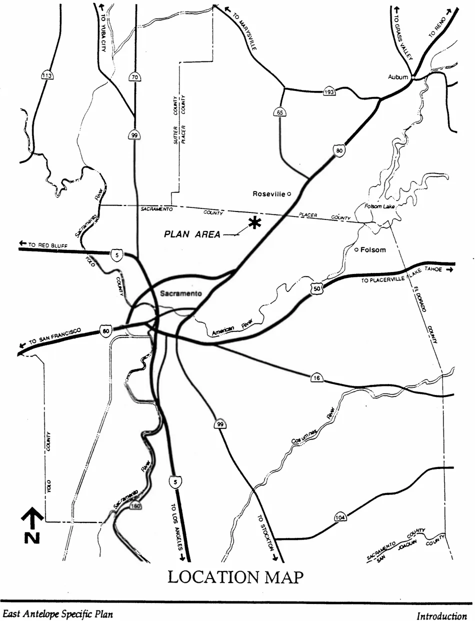
FIGURE 2: AREA-WIDE EXHIBIT
Section titled “FIGURE 2: AREA-WIDE EXHIBIT”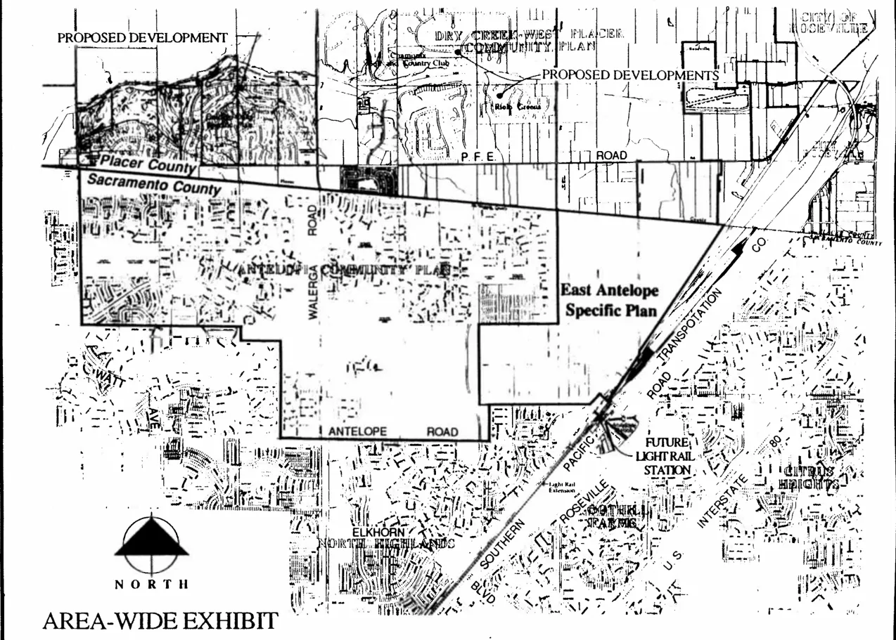
ADJACENT LAND USES
Section titled “ADJACENT LAND USES”The Southern Pacific Railroad Roseville Yard is immediately to the east. It covers an area about 1,500 feet wide and three miles long. The railyard is the main switching yard for Trans-Sierra trains. (See Subarea and Surrounding Land Use Exhibit, Figure 3.) Adjacent land uses to the south include two residential developments: Antelope Hills Unit No. 5 and Old Downing Place. Vacant land planned for park and industrial uses exist to the south along Antelope North Road. A 230 kilovolt (kv) SMUD transmission line runs adjacent to the south and west plan boundary. Vacant land exists adjacent to the west. These large land holdings are owned by the Barrett family and are planned for urban-residential land uses by the Antelope Community Plan. Existing and approved residential land uses exist to the northwest, including Highland Hills, Antelope Estates, Antelope Parkside, and D.O. Greens. Antelope Crossing Middle School and Tetotom Park lie approximately one-half mile to the west. In Placer County agricultural-residential land uses include a production nursery and vacant land. The Dry Creek Elementary School is approximately 1,000 feet to the north, at P.F.E. Road and Cook-Riolo Road.
EXISTING LAND USE
Section titled “EXISTING LAND USE”Discussion within this Specific Plan divides the 673 acre Plan Area into four subareas: Northern, Eastern, Central, and Western. (See Figure 3.) These subareas correspond with existing parcelization, ownership interest, and physical characteristics.
Northern Subarea: This subarea consists of approximately 141 acres and is characterized by relatively large parcelization, twenty acres and larger, with a few exceptions. Of fifteen existing parcels within this area, six are occupied. Most homes are of older construction. A production nursery existed on the northern properties, but has been removed. Two small-scale industrial uses exist On the west side along Antelope North Road.
Eastern Subarea: This triangle-shaped subarea covers approximately 149 acres. Existing development includes a mix of industrial uses. These uses include rail-related industrial, mixed use industrial (small lease space), and three auto dismantlers. The predominant industrial use within the subarea is auto dismantling, recycling, and salvaging. Approximately sixty-five acres within this subarea is vacant, generally to the north. Parcel size is large, generally twenty acres and greater.
FIGURE 3: PLANNING SUBAREAS AND SURROUNDING LAND USE
Section titled “FIGURE 3: PLANNING SUBAREAS AND SURROUNDING LAND USE”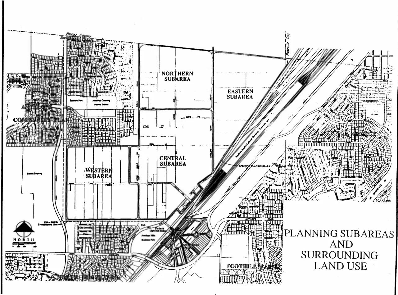
Central Subarea: The Central Subarea includes over 229 acres and is dominated by agricultural-residential land uses with parcels typically two to five acres in size. Two significant exceptions include the Tribune Company (forty-four acres) and Crowder (twelve acres) properties along Antelope North Road. Fifty of the sixty-nine existing parcels are currently developed with residential units. This subarea has a mix of both well established and recent residential construction. Most developed properties have substantial improvements including landscaping, pools, ponds, and accessory buildings.
The Tribune Company property contains a radio antenna array of four towers. The remains of the original Antelope Station Townsite exists on the east side of Antelope North Road. Northern half of the townsite has been developed with industrial uses. The southern portion contains several old residences.
Western Subarea: This subarea covers approximately 151 acres along the Poker Lane corridor. This subarea contains relatively larger parcelization, approximately five to ten acres in size. While some recent residential development has occurred, overall this area has older homes with less substantial property improvements. A total of twenty-four parcels exist in this area, eighteen of them are developed.
PHYSICAL CONDITIONS
Section titled “PHYSICAL CONDITIONS”Various physical conditions exist which create opportunities and constraints for development within the Plan Area. Main examples include drainage, existing road patterns, and existing public facilities. Additional discussion of physical conditions is in the following sections of this Specific Plan. A more detailed discussion of existing physical conditions is included in the Existing Conditions Report in the Appendix.
RELATIONSHIP TO OTHER REGULATIONS
Section titled “RELATIONSHIP TO OTHER REGULATIONS”County General Plan: The East Antelope Specific Plan is directed by the Sacramento County General Plan, including related policies and requirements. The Specific Plan implements the General Plan with additional policies and development regulations focused on the East Antelope area. For discussion on consistency with the County General Plan, see the Land Use Plan section of this text.
Discussion of General Plan consistency with particular policies is found throughout the text of this Specific Plan. This discussion is shown in italics.
North Highlands/Foothill Farms Community Plan: The Specific Plan Area is within the North Highlands/Foothill Farms Community Plan. The Community Plan includes detailed land use designations, as well as area-wide policies for development. Development projects within the Antelope portion of the North Highlands/Foothill Farms Community Plan are reviewed by the Antelope Community Planning Advisory Council formed in 1990.
The East Antelope Specific Plan provides more detailed land use policies, development requirements, and Infrastructure Plans which directly implement the County General Plan. For this reason, the East Antelope Specific Plan supersedes the existing North Highlands/Foothill Farms Community Plan for the area covered by the Specific Plan. Development projects which are filed within the Specific Plan boundary, or amendments to the Specific Plan, do not require a corresponding change to the North Highlands/Foothill Farms Community Plan. If the Specific Plan boundaries are proposed to be amended, a Community Plan Amendment may be required.
County Ordinance: The Specific Plan describes development regulations and design guidelines for development within the Plan Area. Development regulations and design guidelines regulate development within the Specific Plan Area and are included in Title VI of the Sacramento County Zoning Code. No provision of this Specific Plan is intended to repeal, abrogate, annul, impair or interfere with any existing County Ordinance except as specifically repealed by adoption of this Plan or subsequent, related ordinance amendments.
RELATIONSHIP OF SPECIFIC PLAN TO CEQA
Section titled “RELATIONSHIP OF SPECIFIC PLAN TO CEQA”In compliance with the requirements of the California Environmental Quality Act (CEQA) and the Sacramento County Procedures for Preparation and Processing of Environmental Documents, an Environmental Impact Report (EIR) has been prepared for the Specific Plan and circulated for review and comment. The East Antelope Specific Plan EIR addresses the potential environmental impacts which might result from the implementation of the Plan, and discusses project alternatives and mitigation measures. For additional information on CEQA review of individual development projects, see the Administration section of this Specific Plan.
CONFLICT WITH OTHER REGULATIONS
Section titled “CONFLICT WITH OTHER REGULATIONS”This Plan may impose more restrictive regulations or otherwise establish more restrictive regulations than are imposed or required by either ordinances, codes, Or regulations. In such event, those more restrictive regulations shall be implemented by zoning ordinance applicable to the Specific Plan Area.
AUTHORITY
Section titled “AUTHORITY”The County of Sacramento adopted this Specific Plan in accordance with authority granted by California Government Code, Title 7, Division 1, Chapter 3, Article 8, Sections 65450 through 65457 (Planning and Land Use Law). These statutes require a Specific Plan to include minimum contents, and be consistent with the County General Plan. Sacramento County Ordinance Title 21, Chapter 21.14 establishes procedures for initiation, preparation, and adoption of Specific Plans within the unincorporated portion of Sacramento County. The East Antelope Specific Plan has been processed in accordance with these requirements.
LAND USE PLANNING HIERARCHY
Section titled “LAND USE PLANNING HIERARCHY”This Specific Plan contains a combination of goals, policies, development regulations, and design guidelines which direct land use development in the Plan Area. The following describes the land use planning tools found within this Specific Plan.
-
Goals are generalized statements of a desired state or condition at some future time. A land use planning goal describes the end product of the Plan, not necessarily how to reach that end.
-
Policies are guiding statements that direct how future land use decisions are made. Land use policies are usually general in nature and describe the “intent’ of the County Board of Supervisors in approving the Specific Plan. Policies state how goals will be accomplished.
-
Development Regulations (sometimes referred to as ‘standards’) implement stated policies. These planning tools are usually detailed and describe how development is to occur. Examples include building requirements, such as setbacks or lot area.
-
Design Guidelines are similar to development regulations, but are more general and sometimes more flexible. Guidelines are statements of more subjective design issues, such as internal street design or house orientation on lots.
Combined, these land use planning tools provide the necessary steps for development, from broad statements of intent to implementation and construction.
4. LAND USE COMPONENTS
Section titled “4. LAND USE COMPONENTS”LAND USE PLAN
Section titled “LAND USE PLAN”Land Use Plan: The East Antelope Specific Plan Land Use Plan is shown as Figure 4. The Plan shows the Northern and Western Subareas as urban-residential uses. The Central and Eastern Subareas reflect land uses defined by the existing Community Plan. A Land Use Table of acreages and allowable dwelling units is shown as Table 1.
Each land use group has particular issues and needs. Discussion of land use within this plan is broken down into groups including Urban Residential, Agricultural Residential, and Industrial/Commercial. Each section includes a more detailed description of the plan concepts, and includes focused polices, development regulations, and in some cases, design criteria.
Concept: As described in the Introduction section, the East Antelope Specific Plan is located in a predominantly urban portion of Sacramento County. In this context, the Planning Area can be viewed as “large scale in-fill”, rather than a new growth area.
General Plan Policy LU-2 gives priority to residential development on vacant or underutilized sites within existing urban areas which have infrastructure capacity available. The Land Use Element makes specific reference to the Poker Lane area as an example of in-fill areas within established urban communities. Development of the East Antelope area is consistent with the ‘build-out of vacant urban lands’ strategy found in the General Plan Land Use Element. Land Use Policy LU-7 discourages non-contiguous or ‘leapfrog’ development. Development included in this Plan is adjacent to existing urbanized areas and is consistent with this policy.
The Land Use Plan shows urban-residential uses in the Northern and Western Subareas while the Central Subarea remains agricultural-residential land use. The Eastern Subarea remains in industrial land uses. This configuration of urban and agricultural residential land uses is opposite to land use policies found in the County General Plan. Proximity of future light rail facilities at Antelope Road to the south suggest higher density land uses in portions of the Central Subarea with lower densities further away. Regional Transit has adopted plans for a light rail station at Antelope Road and Roseville Road. This station is part of a planned light rail line extension from the existing Watt Avenue Station.
Portions of the Central Subarea lie within one-half mile of the planned Antelope Road light rail station and are subject to minimum density and intensity requirements of General Plan Policy LU-14. Remaining portions of the Central Subarea and the Northern and Western Subareas are beyond the one-half mile area of influence. See Figure 5, Area of Influence - Future Antelope Road Light Rail Station.
FIGURE 4
Section titled “FIGURE 4”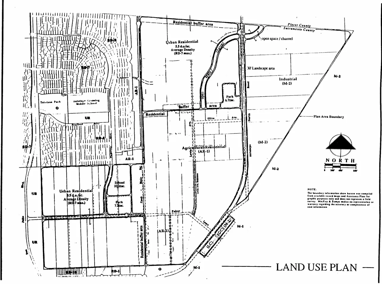
TABLE 1: LAND USE ANALYSIS
Section titled “TABLE 1: LAND USE ANALYSIS”This table has been split into multiple tables to comply with accessibility requirements.
| Northern Subarea Land Use | Acres | Units |
|---|---|---|
| Urban Residential 5.5 du/ac average* | 127.7± | 702 |
| Buffer Area*** | (12.2±) | |
| Park | 6.3± | |
| Chanel | 6.9± | |
| Major Road | (2.1±) | |
| Total | 140.9± | 702 |
| Western Subarea Land Use | Acres | Units |
|---|---|---|
| Urban Residential 5.5 du/ac average* | 133.5± | 734** |
| Buffer Area*** | (5.2±) | |
| School | (10.0±) | |
| Park | 6.3± | |
| Total | 151.0± | 734 |
| Subtotal - Urban Areas | 1,436 |
| Central Subarea Land Use | Acres | Units |
|---|---|---|
| AR-1 | 215.4± | 215 |
| RD-2 | (2.3±) | 4 |
| M-2 | (5.8±) | |
| LC | 3.5± | |
| GC | 1.7± | |
| Major Road | (6.3±) | |
| Total | 228.7 | 219 |
| Eastern Subarea Land Use | Acres | Units |
|---|---|---|
| M-2 | (147.0±) | |
| Channel | 1.9± | |
| Major Road | (3.8±) | |
| Total | (148.9±) | |
| Grand Total | (669.5±) | 1,655 |
*Averaged residential density allows range of land use densities up to 7 du/ac.
**Unit Count is maximum overall allowable for subarea. Minimum overall allowable is 75% of maximum.
***Buffer Areas required by specific plan policy but included in average density calculations.
Policies within the Land Use Plan and Agricultural-Residential portions of this Plan identify land uses consistent with proximity of the Antelope Road light rail station as the ultimate land use in the Central Subarea. However, the timing of this ultimate land use is dependent on the timing of light rail construction or availability of key, large acreage parcels. Policies are included in the Agricultural-Residential portion of this Plan which recognize the existence of Agricultural-Residential uses, yet establish timing criteria for future conversion of Central Subarea land uses.
FIGURE 5: AREA OF INFLUENCE - FUTURE ANTELOPE ROAD LIGHT RAIL STATION
Section titled “FIGURE 5: AREA OF INFLUENCE - FUTURE ANTELOPE ROAD LIGHT RAIL STATION”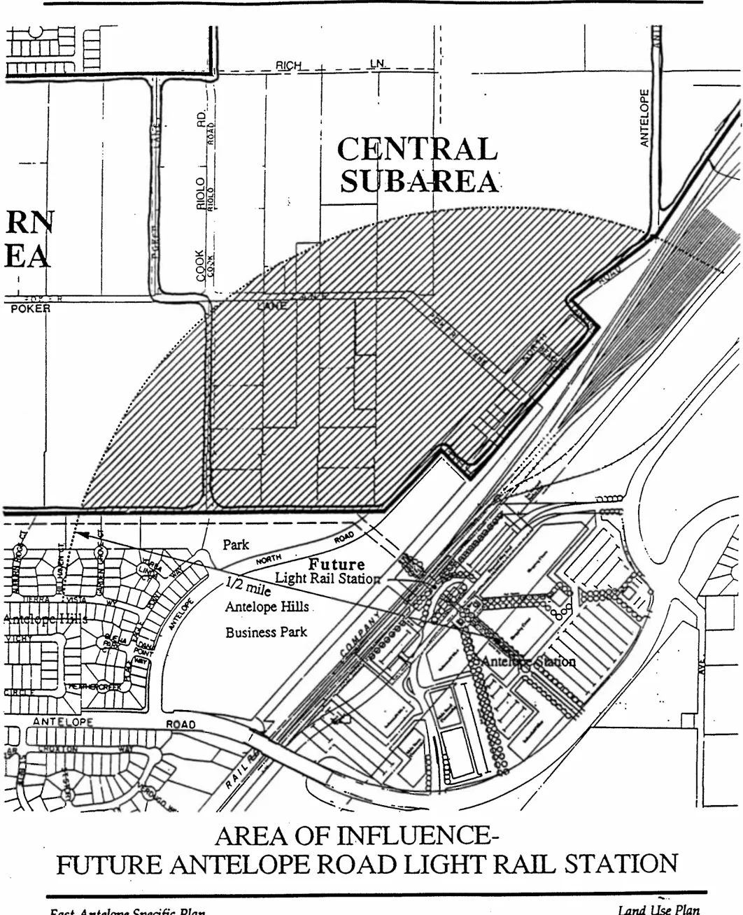
Portions of the Central Subarea are significantly built-out at agricultural-residential densities (AR-2), particularly the western and northern portions. These portions may not convert to urban uses due to the value of existing improvements and difficulties of assembling smaller properties. Policies within the Agricultural-Residential section of this Plan recognize the established agricultural-residential areas and provide for the development of these areas to AR-1 densities.
General Plan Land Use Element Policy LU-14 sets forth density requirements for development in proximity to transit stops or transportation corridors. Policy LU-28 directs Specific Plans to designate locations for high density core areas and pedestrian networks. These policies are a key component of the General Plan land use strategy to reduce traffic congestion and improve air quality. This Specific Plan describes constraints where Policies LU-14 and LU-28 are not appropriate at the inception of the Plan. However, this Plan identifies the Central Subarea for higher density development at some time in the future. This allows the implementation of Policies LU-14 and LU-28 at the appropriate time.
General Plan Land Use Element Policy LU-18 discusses compatibility of new development with surrounding development. Overall Policy No. 4, Page 16, provides for buffering of incompatible land uses. Implementation of Policy No. 4 is found in the Urban Residential, Agricultural -Residential, and Industrial/Commercial sections of this Plan.
GOALS - SPECIFIC PLAN
Section titled “GOALS - SPECIFIC PLAN”The East Antelope Specific Plan will provide the tools to allow urban development to proceed while addressing constraints inherent in the Plan Area. While certain areas are planned for urban densities, other areas will maintain existing land uses for some time. Overall goals of the Specific Plan are as follows:
- Provide a mix of urban-residential land uses that efficiently utilize existing public infrastructure and the potential for nearby transit facilities.
- Provide for orderly development within the Plan Area through the use of phasing and implementation measures to ensure timely delivery of services to new urban land uses.
- Provide urban-residential land uses that maintain the quality and character of existing agricultural-residential and industrial land uses through the use of appropriate development regulations, design guidelines, or other buffering techniques.
- Transit-related urban land uses which support the planned Antelope light rail station are considered the ultimate land use in portions of the Central Subarea.
- Plan the development of urban areas so as to maintain future options within Central Subarea through appropriate infrastructure plans.
- Enhance community identity and character through use of development regulations and design criteria, including attention to pedestrian circulation and public open space.
- Encourage the retention and in-fill of the industrial and commercial uses east and south of Antelope North Road.
- Ensure land use compatibility by providing appropriate buffers between uses.
POLICIES - SPECIFIC PLAN
Section titled “POLICIES - SPECIFIC PLAN”Land use policies that apply throughout the Specific Plan Area are discussed below. Focused policies for particular land uses are provided in following sections of this plan.
- This Specific Plan implements the Sacramento County General Plan. Thus, the planning horizon, or “life” of this Plan, shall be year 2010, the same horizon as the General Plan. An overall update of this Plan should be considered at the end of this planning horizon or when conditions change sufficiently to support consideration of a different land use pattern.
- Urban development within this Plan shall efficiently utilize existing public facilities so as to minimize the need for costly infrastructure extensions elsewhere.
- Urban land uses shall be focused within the Northern and Western Subareas. Existing land uses within the Central and Eastern Subareas shall be maintained.
- Development shall incorporate a design of buffering potentially incompatible adjacent land uses to ensure compatibility and avoid future land use conflicts.
GENERAL PLAN CONSISTENCY
Section titled “GENERAL PLAN CONSISTENCY”The Specific Plan Area is included within the Urban Policy Area and Urban Service Boundary of the General Plan. A General Plan Amendment to the General Plan Land Use Map was required prior to adoption of this Specific Plan from Agricultural-Residential (1 to 10 ac/du) to Low Density Residential (1 to 12 du/ac) for the Northern and Western Subareas. The East Antelope Specific Plan is found to be consistent with the County General Plan as amended.
The General Plan contains strategies to accommodate projected growth within the County. This Specific Plan deals with several key policies found in the General Plan. Key General Plan issues are summarized below.
- Several Land Use Element policies describe land uses in proximity to major transit facilities, such as light rail. This Plan recognizes the need for urban land uses near the planned Antelope Road light rail station, and provides a timing mechanism to ensure an appropriate transition from existing agricultural-residential uses.
- Land Use Element policies discuss the integration of agricultural-residential areas within urban areas and the provision for services (LU-43, -46, -47, and -49). This Plan sets forth policies and design guidelines to maintain the continued existence of agricultural-residential uses and provision of public facilities to those areas.
- Conservation policies establish strategies for dealing with drainage and water supply issues (CO-9, -20, and -21). The Public Facilities section of this Plan describes master plans for provision of services to the Plan Area. For example, domestic water supply includes discussion of an agreement among north County water purveyors to provide conjunctive use of groundwater and surface water.
More detailed discussion of General Plan consistency with particular policies is found throughout this text. This discussion is shown in italics. Table 2 shows the particular policies and where discussion within the text can be found.
TABLE 2: GENERAL PLAN POLICY REFERENCE
Section titled “TABLE 2: GENERAL PLAN POLICY REFERENCE”| GENERAL PLAN POLICY | SUBJECT | LOCATION OF DISCUSSION |
|---|---|---|
| LU-2 | In-Fill Development | Page 11 |
| LU-7 | ’Leapfrog’ Development | Page 11 |
| LU-8 | Financing Plans | Page 70 |
| LU-13 | Pedestrian Access | Page 37 |
| LU-14 | Transit-Oriented Development | Page 15 |
| LU-18 | Neighborhood Compatibility | Page 15 |
| LU-28 | Locating Core Areas | Page 15 |
| LU-39 | Industrial Land Supply | Page 29 |
| LU-43 & LU-46 | Agricultural-Residential | Page 27 |
| LU-47 | Services to Ag-Res. Areas | Page 48 |
| CI-23 | Traffic Levels of Service | Page 35 |
| CO-9 | Stormwater Quality | Page 46 |
| CO-20 & CO-21 | Water Supply Master Plan | Page 49 |
| PF-38 | School Sites | Page 53 |
| PF-50 | Library Financing | Page 71 |
| AQ-9 | Regional Transit Funding | Page 36 |
URBAN-RESIDENTIAL LAND USE
Section titled “URBAN-RESIDENTIAL LAND USE”CONCEPT
Section titled “CONCEPT”The Land Use Plan shows urban-residential land use densities within the Northern and Western Subareas. The use of an average density, rather than a maximum density, provides diversity in the type of lot and house designs. That is, portions of a subarea may utilize a higher density land use, RD-7 for example, provided that other portions of the subarea are developed at lesser densities to balance. The average 5.5 du/ac density also establishes a density cap for development within each subarea. A minimum density of 75% of maximum, or 4.1 du/ac is included.
The Northern and Western Subareas are related to the Central Subarea in forming land in support of the planned Antelope Road light rail station. The Land Use Plan section of this Plan discusses the Central Subarea and the issue of agricultural residential versus urban land uses. The Northern and Western Subareas will be developing in advance of potential urban uses in the Central Subarea. Development in the Northern and Western Subareas will include measures, such as road easements to ensure future access to the Central Subarea.
Urban residential development in the Northern and Western Subarea is a logical extension of adjacent developments in the Antelope community to the west. Extensions Of existing street patterns integrate the Specific Plan Area as much as possible. (See additional discussion in the Circulation section of this Plan.)
This section includes provisions for buffering of adjacent land uses. For example, the Northern and Western Subareas include RD-2 buffer areas to the Central Subarea. In addition, an RD-4 buffer is included along the Sacramento County line. Finally, measures are included for a landscape corridor and noise barrier along Antelope North Road to buffer both road impacts and industrial uses in the Eastern Subarea.
Site Development Standards are included in the Development Regulation portion of this section. Site Development Standards include provisions for lot dimensions, setbacks, and corner halfplexes. These Standards provide greater flexibility than the Zoning Code regulations that govern the rest of the County and encourage development of non-standard residential housing such as ‘wide and shallow’ or ‘Z’ lot types.
Several policies and development regulations regarding circulation, public facilities, or services affect development in the urban-residential areas. These items are discussed in the Circulation or Public Facilities section of this Specific Plan.
POLICIES-URBAN-RESIDENTIAL
Section titled “POLICIES-URBAN-RESIDENTIAL”- Encourage a range of land use densities within each subarea to create a mix of lot and housing types.
- Design drainage, park, and other open space areas to integrate with the residential neighborhoods.
- Provide adequate buffering within the urban-residential areas where adjacent land uses differ significantly. Buffering can be accomplished through larger lots, additional setbacks, landscape corridors, or any appropriate combination.
- Design of urban-residential areas shall provide future opportunities for development of adjacent agricultural-residential land uses. Examples include sizing on-site infrastructure facilities for additional capacity, street or utility stubs, road easements, or I.O.D.’s.
- Phasing of development within the urban-residential areas shall ensure adequate street access and public utilities during buildout of the subarea.
DEVELOPMENT REGULATIONS-URBAN-RESIDENTIAL
Section titled “DEVELOPMENT REGULATIONS-URBAN-RESIDENTIAL”- Development requirements, such as lot area, lot dimensions, and setbacks, are shown on Table 3 (Site Development Standards). Individual development projects which propose non-standard yard setbacks (i.e., zero lot line, zipper lot) considered.
- Average densities within single-family residential portions of the Northern and Western Subareas shall not exceed 5.5 du/ac. Average density is defined as the average gross density of individual development projects within the subarea. Total dwelling units shown for single-family residential areas on the Land Use Table, Table 1, shall be the maximum allowable for that single-family residential area.
TABLE 3: SITE DEVELOPMENT STANDARDS
Section titled “TABLE 3: SITE DEVELOPMENT STANDARDS”This table has been split into multiple tables to comply with accessibility requirements.
| Development Standards | RD-2 | RD-3 | RD-4 | RD-5 | RD-7 |
|---|---|---|---|---|---|
| Density (1) | 2 du/ac gr. | 3 du/ac gr. | 4 du/ac gr. | 5 du/ac gr. | 7 du/ac gr. |
| Lot Area | 18,000 sq. ft. | 10,000 sq. ft. | 8,500 sq. ft. | 5,000 sq. ft. | 4,000 sq. ft. |
| Corner Lot Area | 18,000 sq. ft. | 10,000 sq. ft. | 8,500 sq. ft. | 6,000 sq. ft. | 4,800 sq. ft. |
| PUE Width adj. to Right-of-Way | 12.5’ | 12.5’ | 10’ | 10’ |
| Lot Dimensions | RD-2 | RD-3 | RD-4 | RD-5 | RD-7 |
|---|---|---|---|---|---|
| - width at setback | 60’ | 60’ | 60’ | 50’ | 40’ |
| - corner width | 75’ | 65’ | 65’ | 60’ | 50’ |
| - frontage at property line | CR (2) | CR (2) | CR (2) | 35’ | 30’ |
| - minimum depth | 120’ | 100’ | 100’ | 85’ | 60’ |
| Minimum Setbacks | RD-2 | RD-3 | RD-4 | RD-5 | RD-7 |
|---|---|---|---|---|---|
| - front | |||||
| - Living Area | N/A (3) | N/A (3) | N/A (3) | 15’ | 15’ |
| - Porch (4) | N/A | N/A | N/A | 10’ | 10’ |
| - Garage | N/A | N/A | N/A | 19’ w/roll up | 19’ w/roll up |
| - side (total bldg. separation) | CR | CR | CR | 10’ | 10’ |
| - corner side | 12.5’ | 12.5’ | 12.5’ | 10’ | 10’ |
| - separate garage | N/A | N/A | N/A | 0’ side & rear | 0’ side & rear |
| - buffer setbacks | |||||
| - residential bldg. | 50’ | 50’ | 50’ | N/A | N/A |
| - accessory bldg. | 20’ | 20’ | 20’ | N/A | N/A |
| Corner Halfplex Standards | RD-2 | RD-3 | RD-4 | RD-5 | RD-7 |
|---|---|---|---|---|---|
| - area-corner | 4,000 sq. ft. | 4,000 sq. ft. | |||
| - area-interior | 3,000 sq. ft. | 3,000 sq. ft. | |||
| - width-corner | 40’ | 40’ | |||
| - width-interior | 30’ | 30’ | |||
| - lot depth | 85’ | 60’ |
(1) Calculated as gross density including major roads and landscape areas.
(3) N/A = Not allowed, or, no provision in County Zoning Code
(2) Countywide Regulation Applies
(4) Minimum vehicular visibility requirements must be met.
-
Individual development projects may not exceed 5.5 du/acre overall. Portions of a project may exceed 5.5 du/ac up to a maximum of 7.0 du/ac provided that lower density areas are included to meet the required average density Minimum density of individual development projects shall be 4.1 du/ac, or 75% of maximum.
Individual development projects may exceed 5.5 du/ac average density only if accompanied with another development application with a lower average density, such that the two projects average 5.5 du/ac. In this case, both development applications must be processed concurrently and a density cap shall be placed on the rezone agreement of both projects.
-
Individual development applications exceeding 5.5 du/ac gross density shall demonstrate that previous individual development applications are at a lower gross density so as to maintain the required 5.5 du/ac average gross density.
-
If the maximum allowable units within a subarea is not reached with individual development applications in that subarea, then the remaining allowable units may be transferred to the other single-family residential subarea, up to 10% of the maximum allowable units of the original subarea.
-
Localized densities within the urban-residential areas shall not exceed 7 du/ac.
-
Corner halfplexes shall be allowed within urban development areas without limitation and without the need for a Conditional Use Permit application.
-
The following items shall be allowed as “encroachments into yard areas” provided they do not reduce the required yard area by more than 24 inches: 1) Bay windows with foundations; and, 2) Fireplaces with adjacent wood box and entertainment center pop-outs.
-
Maximum soundwall height of eight feet is allowed along short portions of the landscape corridor where significant site constraints and grading design justify a higher soundwall; otherwise, maximum soundwall height of six feet shall be used. If an eight foot wall is justified, additional tree planting and screening materials shall be utilized for that area.
-
Rezone and development approvals permitting construction of new homes in the Northern Subarea shall be conditioned to require recordation of notice regarding the existence of industrial uses and M-2 zoning and the Southern Pacific Railroad rail yard on the east side of Antelope North Road.
DESIGN GUIDELINES-URBAN-RESIDENTIAL
Section titled “DESIGN GUIDELINES-URBAN-RESIDENTIAL”Development within the urban-residential areas shall incorporate the following design guidelines. Individual development applications shall be reviewed by the Planning Commission to ensure compliance with stated design guidelines. Where site constraints or other peculiarities can be demonstrated, deviations from these design guidelines can be allowed.
-
Buffering of adjacent agricultural-residential land uses shall utilize designs consistent with concepts shown on Figure 6. Design features include RD-2 sized lots, internally focused circulation, location at end of cul-de-sacs if feasible, back-up house orientation, and setbacks as described in Site Development Standards.
Off-site land uses to the south of the plan area shall be buffered where appropriate (i.e. existing RD-1). Buffering techniques shall be reviewed with the design of tentative maps filed in the Western Subarea.
-
Buffering of adjacent lands in Placer County shall utilize design concepts similar to those described above. RD-4 land uses shall be used in this buffer area.
-
Buffering of industrial-commercial uses across Antelope North Road shall include a thirty-foot landscape corridor along the west side of Antelope North Road. An eight-foot sound barrier (combination wall and berm) shall be located at the rear of the landscape corridor. See Conceptual Landscape Corridor, Figure 7. The landscape corridor and sound barrier will be publicly maintained through a Landscape and Lighting Assessment District.
-
Landscape corridors along Antelope North Road should include the following features and incorporate standards described in Section 301-61 of the Zoning Code except where noted below:
- Provide separated sidewalk within the landscape corridor where feasible except near street intersections.
- All perimeter masonry wall shall be finished with a graffiti resistant coating or be constructed with an anti-graffiti design. This measure should be coordinated with the long-term maintenance entity for landscape corridors.
- Additional road right-of-way for intersection widening and bus turn-outs may encroach into the required landscape corridor area.
- Wall transitions at intersections may be designed to provide a landscaped project entry. Entry islands may include consistent with County Transportation Division requirements.
-
The following lot and architectural design details shall apply:
- Lot and house designs should emphasize the living space with front pop-out porches, or wide building-to-street orientation.
- Lots with a side yard/rear yard configuration are discouraged. Where this configuration is necessary because of lotting pattern design, the side-on lot should incorporate a ten-foot minimum side yard or be limited to a one-story residence. (Note: A split-story house can orient the one-story portion to meet the above requirement.)
- Garages should be recessed into the building architecture where lot design permits. Side-on garages with swing driveways are encouraged.
- House designs with side entry and limited visibility toward the street are discouraged.
FIGURE 6: BUFFER AREA DESIGN CRITERIA
Section titled “FIGURE 6: BUFFER AREA DESIGN CRITERIA”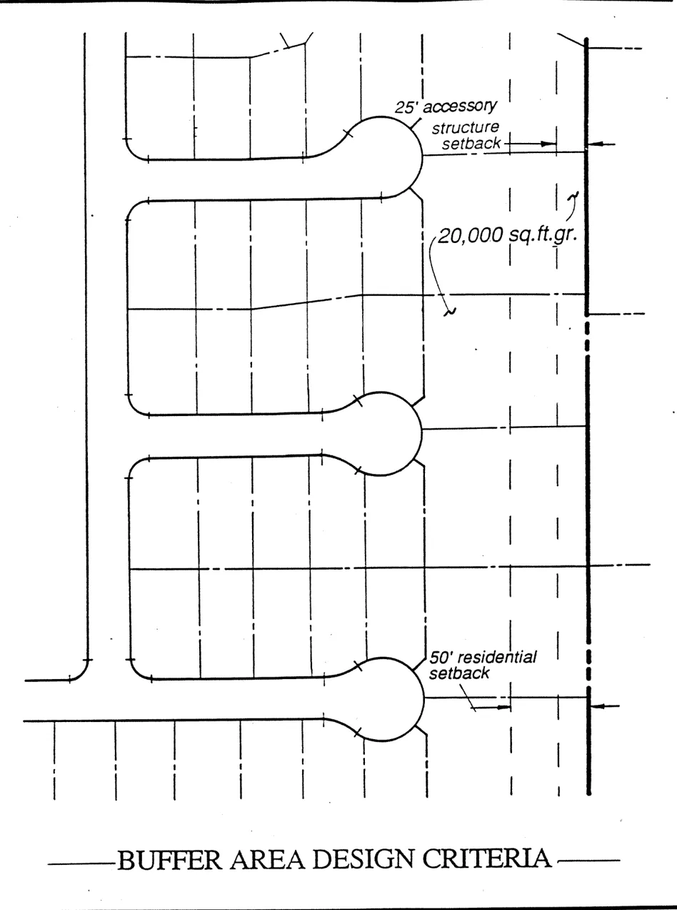
FIGURE 7: CONCEPTUAL LANDSCAPE CORRIDOR, ANTELOPE NORTH ROAD
Section titled “FIGURE 7: CONCEPTUAL LANDSCAPE CORRIDOR, ANTELOPE NORTH ROAD”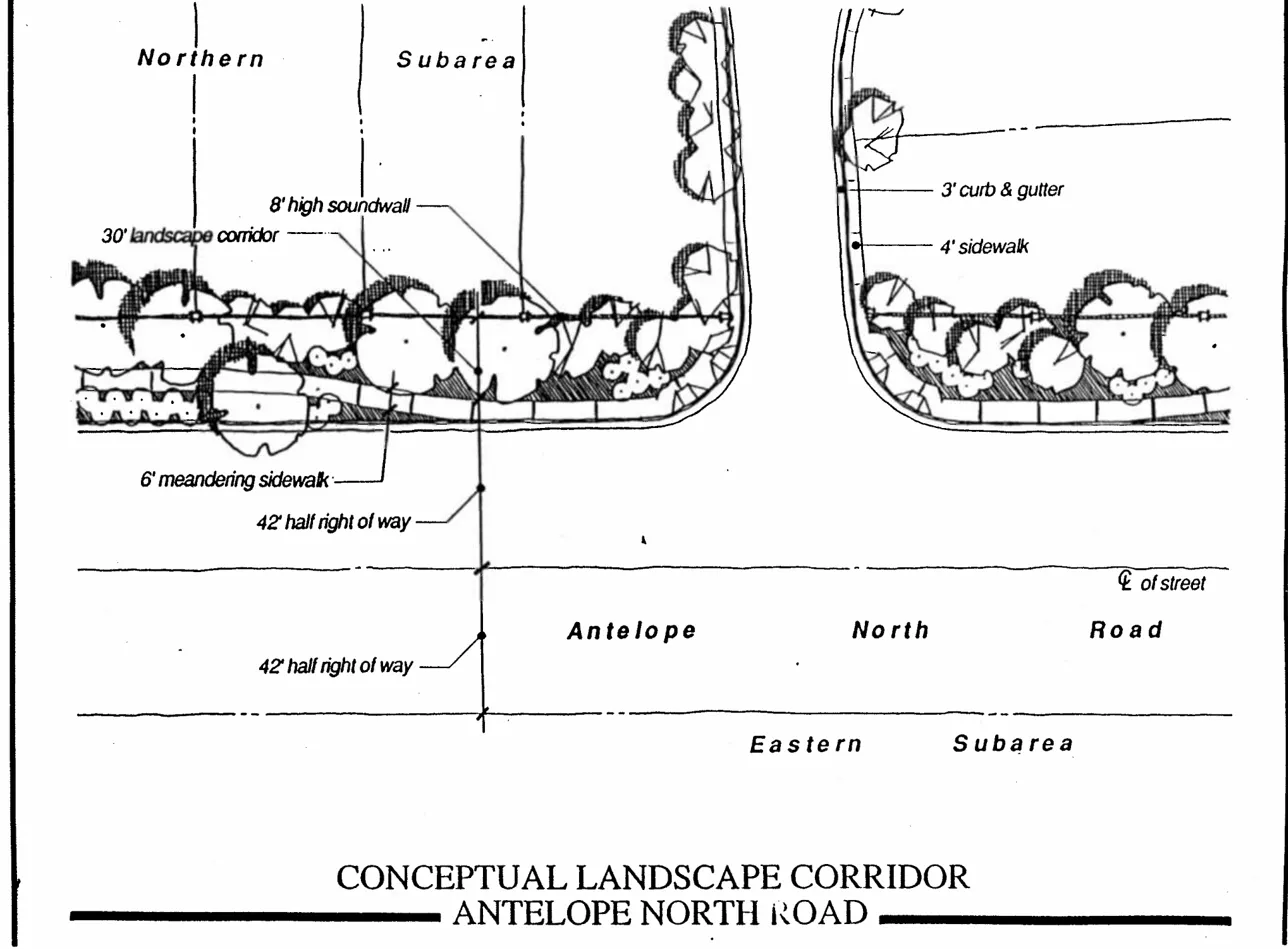
AGRICULTURAL-RESIDENTIAL LAND USE
Section titled “AGRICULTURAL-RESIDENTIAL LAND USE”CONCEPT
Section titled “CONCEPT”As discussed in the Land Use Plan section of this Plan, the Central Subarea is appropriate for transit-related land uses because of the proximity to the planned Antelope Road light rail station. Uncertainty regarding the timing of light rail line extension and station construction creates an issue of the timing of urban land uses in the Central Subarea. Policies are included in this section which provide for a reevaluation of land uses in the Central Subarea at the appropriate time. This section also includes a restriction on larger acreage parcels which may be candidates for future urban land uses. Any conversion to urban uses must meet specific timing criteria, such as construction of light rail facilities.
Policies within this section of the Specific Plan recognize the established agricultural-residential areas and provide for the development of these areas to AR-1 densities. Policies related to circulation, public facilities, or services in the Central Subarea are found in the Circulation or Public Facilities section of this Specific Plan.
General Plan Land Use Policies LU-43 and LU-46 provide for agricultural-residential areas within urbanized portions of Sacramento County when “functionally integrated with other urban uses and infrastructure is provided”. This Specific Plan provides for agricultural-residential land uses in the Central Subarea to protect existing uses and the integrity of the existing neighborhood in the near term.
POLICIES-AGRICULTURAL-RESIDENTIAL
Section titled “POLICIES-AGRICULTURAL-RESIDENTIAL”-
Recognize and protect the agricultural-residential character of the Central Subarea, while not precluding long-term phasing to urban uses.
-
Central Subarea where substantial property improvements and parcelization has occurred (western and northern portions).
-
Large acreage parcels (ten acres and larger) in portions of the Central Subarea in proximity to planned light rail facilities, as defined by General Plan Policy LU-14, shall not develop to AR-1 land uses.
-
Urbanizing the Central Subarea shall not be considered until one of the following conditions exist:
- Substantial progress has been made toward financing and construction of the Antelope Road light rail station; or,
- Radio broadcast technology has rendered radio towers on the Tribune property (A.P.N. 203-0260-060) unnecessary or the property owner chooses to remove the towers for other reasons; or,
- Any conversion proposal include a coherent combination of properties within the Central Subarea so as to avoid piecemeal development within the subarea.
-
Any development proposal for AR-1 land use in the Central Subarea shall be reviewed by the Planning and Community Development Department to ensure that future opportunities for urban development are preserved (i.e., circulation, public facilities, etc.).
-
Provisions shall be included in development of adjacent urban-residential areas for adequate loop circulation in the Central Subarea. (See Circulation Policies.).
-
Establishment of large-scale, long-term agricultural uses are not consistent with the Central Subarea’s status as a transitional agricultural-residential land use.
-
A 200± foot setback from the centerline of Antelope North Road shall be required for any new Agricultural-Residential primary outdoor activity areas (such as porches, patios, swimming pools, etc.) in the Central Subarea.
Any development of Central Subarea properties within 200 feet of the centerline of Antelope North Road shall require a Development Plan Review by the Planning Department (to insure compliance with noise mitigation found in the Specific Plan EIR).
INDUSTRIAL-COMMERCIAL LAND USE
Section titled “INDUSTRIAL-COMMERCIAL LAND USE”CONCEPT
Section titled “CONCEPT”The Eastern Subarea is currently zoned M-2, Heavy Industrial, and is to remain. Existing industrial uses are expected to continue their operations. Issues related to this area include compatibility with adjacent urban-residential uses and preservation of existing uses. Provisions are included for review of potential, future industrial uses. The northwest corner of this subarea will contain an open space/channel area and stormwater treatment facility. A “panhandle’ of M-2 land uses is shown along the east side of realigned Antelope North Road. This area is an extension of the existing M-2 uses to the north. Two small-scale industrial operations exist on the west side of Antelope North Road and are subject to the provisions of this section.
General Plan Land Use Element Policy LU-39 provides for adequate industrial land supply to encourage growth of industrial land use and diversify the Sacramento County economy. The East Antelope Specific Plan includes 154.9± acres, or 23% of the total Plan Area, as industrial land use. In addition, measures are included in this Plan to protect existing industrial uses from potential incompatibilities with nearby urban-residential development.
A portion of the Antelope Station Townsite is located in the Central Subarea. A combination of commercial and industrial uses are shown. The GC, General The southern townsite portion is proposed for LC, Limited Commercial, land use. The intent is to provide neighborhood commercial uses that would serve local commercial needs. A few commercial land use policies are included since the proposed commercial areas are relatively small.
The Eastern Subarea will not be annexed to the existing Antelope Public Facilities Financing Plan, but will be instead subject to County-wide financing mechanisms.
POLICIES-INDUSTRIAL
Section titled “POLICIES-INDUSTRIAL”- Zoning conditions, development conditions, and other controls, including but not by way of limitation, requirements for adequate notice and buffering, shall be used to protect existing industrial land uses from potential incompatibilities created by development of nearby urban-residential areas. (See measures included in the Urban Residential section of this text.)
- Existing industrial land uses shall comply with development regulations as established in the Sacramento County Zoning Code.
- Existing industrial land uses that are rendered non-conforming uses by adoption Of this Specific Plan shall be allowed to continue under the “non-conforming use” provisions of the Sacramento County Zoning Code. Existing industrial land uses which are in violation of the County Code shall continue to be considered violations after adoption of the Specific Plan, and zoning enforcement actions shall be pursued by Sacramento County in accordance with standard practices.
- Future industrial developments shall be controlled through use permits or other requirements to prevent incompatibilities with surrounding urban-residential, agricultural-residential, school, park, or other land uses.
- Development within the Eastern Subarea shall not be annexed to the Antelope Public Facilities Financing Plan, but shall be subject to other adopted region-wide or County-wide financing mechanisms.
POLICIES - COMMERCIAL
Section titled “POLICIES - COMMERCIAL”- Commercial development within the Antelope Station Townsite shall not be restricted by the timing of future land uses in the balance of the Central Subarea.
- Development within the LC portion of the Antelope Station Townsite should be coordinated to ensure compatibility and a consistent architectural theme.
DEVELOPMENT REGULATIONS-INDUSTRIAL
Section titled “DEVELOPMENT REGULATIONS-INDUSTRIAL”-
Proposed future industrial uses allowed by right in the M-2 classification shall be subject to review by the Planning Director prior to issuance of any building permits. If the Director finds that the proposed use may result in potential odors, fumes, dust, noise, vibrations, or other such emissions which constitute a potential health hazard or nuisance to adjacent or surrounding properties, the proposed use shall be subject to issuance of a Conditional Use Permit by the Project Planning Commission.
Any proposed future industrial uses in the M-2 classification which are subject to issuance of a Conditional Use Permit by the Zoning Administrator pursuant to Section 230-13 of the Zoning Code shall instead be subject to issuance of a Conditional Use Permit by the Project Planning Commission.
-
Existing industrial uses subject to currently valid use permits or other entitlements shall not, for the purposes of development regulations, be considered ‘future industrial uses’ solely because a use permit or other entitlement must be renewed.
5. TECHNICAL COMPONENTS
Section titled “5. TECHNICAL COMPONENTS”CIRCULATION
Section titled “CIRCULATION”CONCEPT
Section titled “CONCEPT”The East Antelope Specific Plan provides a comprehensive circulation system for safe and efficient movement within and through the Plan Area. The Circulation section of this Plan divides the discussion into Traffic Circulation, Transit, and Pedestrian/Bicycle. (See Figure 8, Circulation Plan, to illustrate circulation patterns described below.)
Traffic Circulation
Section titled “Traffic Circulation”Circulation to external streets utilizes existing roads as much as possible. To the west, Pearlstone Drive and Whitehaven Way are the only street connections to existing developments in the Antelope community. These streets are extended into the Northern Subarea. Poker Lane west of Cook-Riolo Road and the extension of Palmerson Drive requires an external connection to Don Julio Boulevard and the extension of Palmerson Drive, to complete loop circulation in the Western Subarea. Cook-Riolo Road in Placer County will not extend into the Plan Area. Circulation Break “A” is included at the northwest corner of the Northern Subarea to prevent through access.(See Figure 10.)
Circulation internal to the Plan Area contains several components. Two-lane Antelope North Road traverses the Plan Area and has long been designated as a planned arterial and number of access points along Antelope North Road is controlled to limit turning movements and exposure to adjacent industrial uses. Other major roadways providing circulation access to the Specific Plan Area include Don Julio Boulevard, Antelope Road, and Roseville Road. Improvements to these facilities have been financed by the Antelope Public Facilities Financing Plan.
Internal circulation between the urban-residential areas and the Central Subarea is’ restricted since through traffic into the Central Subarea is considered undesirable as long as agricultural-residential land use dominates. Circulation Break “B” is planned along Poker Lane (in addition to that planned at the Sacramento County line). (See Figures 10 and 11.) However, provisions are included for emergency access. Provisions are included to preserve future opportunities for street access to the Central Subarea. While local street circulation is not appropriate at this time, the potential for future urban land uses in the Central Subarea justify provisions for street stubs, I.O.D’s, or Other measures to be included in design of the urban-residential areas.
FIGURE 8: CIRCULATION PLAN
Section titled “FIGURE 8: CIRCULATION PLAN”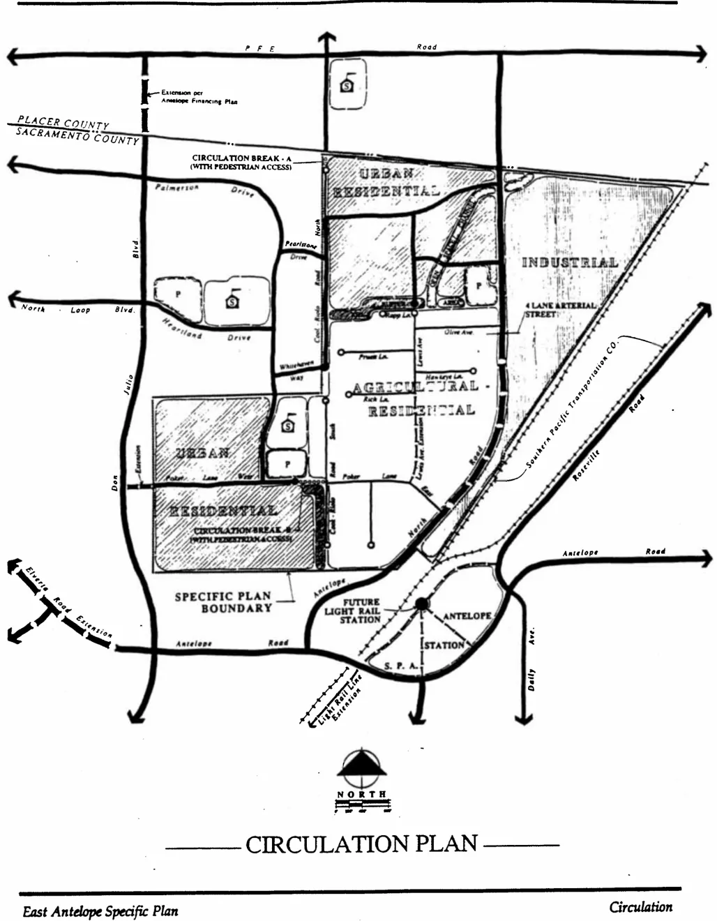
FIGURE 9: STREET SECTIONS
Section titled “FIGURE 9: STREET SECTIONS”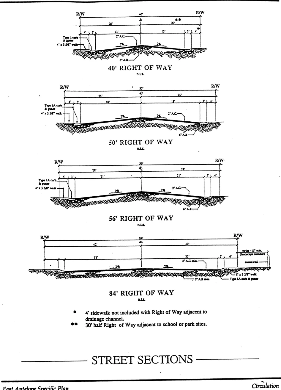
Collector streets will traverse the Northern and Western Subareas, creating links between these neighborhoods and community-serving facilities in the Antelope community, including schools and parks. Local street patterns will follow traditional design to efficiently carry local traffic. Internal circulation in the Northern Subarea will include one road crossing of the drainage channel; however, designs should incorporate street patterns to minimize through (west to east) traffic out to Antelope North Road. Consideration is given to design of local streets around open space areas, such as school, park, and drainage channel. Internal circulation in the Central Subarea is maintained with the extension of Lewis Avenue to Poker Lane. This extension will connect two portions of the Central Subarea that. would otherwise be separated.
Streets within the Specific Plan Area will be constructed to establish County Improvement Standards and includes 40-foot, 50-foot, 56-foot, and 84-foot street sections. (See Street Sections Exhibit, Figure 9.) Size of streets to be determined by County staff with review of individual development applications.
General Plan Circulation Element Policy CI-23 requires mitigation measures when traffic impacts from new development do not meet certain level of service criteria. The Environmental Impact Report prepared for this Plan identified specific impacts and mitigation measures. Feasible measures are included in the Capital Improvement Program or in the Circulation portion of this text.
TRANSIT
Section titled “TRANSIT”Transit opportunities for the East Antelope Specific Plan focus on the planned light rail station at Antelope Road and Roseville Road. This station is part of a planned light rail extension from the existing Watt Avenue station. While track alignment and station location is planned, questions of project funding will affect timing of the light rail line extension.
Several factors affect the ability to maximize transit opportunities provided by the future Antelope Road light rail station. The station is planned on the east side of the Southern Pacific Railroad tracks, which constitutes a substantial barrier to light rail users to the west. Bus and vehicular access to the station is via the Antelope Road overcrossing. Preliminary station designs include a pedestrian undercrossing to the west side of the Southern Pacific Railroad tracks. However, these station designs are very general and will change. Another option is a pedestrian and bicycle overcrossing which may be less costly and less complicated. The potential exists for a park and ride facility on the west side of the tracks along Antelope North Road (approximately 600 feet south of the Specific Plan Area).
The Northern and Western Subareas qualify as “secondary areas” to the light rail facilities according to County Transit-Oriented Development Guidelines. Portions of the Central Subarea would serve as Neighborhood Core Area with high land use densities because of the proximity of the light rail station. However, with AR-1 as an interim land use in the Central Subarea, no direct land use link to transit can be established. It is also not desirable to integrate internal circulation between the subareas. The potential exists, however, for future urban land uses in the Central Subarea. (See Agricultural-Residential section.). If a conversion to urban uses is considered, transit-oriented land use and design features can be implemented.
Despite separation of the Northern and Western Subareas from future light rail service, measures are included to encourage transit use. (See Development Regulations and Design Criteria - Circulation). First, access breaks on Cook-Riolo Road and Poker Lane will allow pedestrian and bicycle access through the Central Subarea. Internal circulation in the Northern Subarea should provide reasonable pedestrian/bicycle access to Antelope North Road.
Tentative plans for feeder bus routes include north-south travel along Don Julio Boulevard, Walerga Road, and Watt Avenue to respective light rail stations. No plans exist for feeder bus routes along Antelope Road or Antelope North Road. However, the potential exists for loop bus service from Antelope light rail station along Antelope North Road and points westward. Bus stops are incorporated into the design of Antelope North Road per County Improvement Standards.
General Plan Air Quality Element Policy AQ-9 requires that adequate funding for Regional Transit be secured and that development pay fair share cost of transit facilities to serve the development. This Specific Plan will participate in any County-wide funding source for Regional Transit. In addition, new development will pay a Transit Development Fee with building permits as a component of the County-wide Transportation Development Fee.
PEDESTRIAN/BICYCLE
Section titled “PEDESTRIAN/BICYCLE”Pedestrian and bicycle use within the Plan Area will focus on access to the planned Antelope Road light rail station, to the nearby school and park facilities, and will enhance internal circulation.
Internal circulation is accomplished through street designs that include multiple access routes and avoid barriers to movement. Pedestrian/bicycle access to surrounding urban-residential areas is accomplished through connections to existing streets, such as Palmerson Drive, Pearlstone Drive, and other minor residential streets. These connections also provide access to the nearby Antelope Crossing Middle School and Tetotom Park.
A road crossing of the Northern Subarea channel is included. The channel bisects the subarea and a road crossing will enhance internal pedestrian/bicycle access, as well as vehicular access. The potential exists for pedestrian use of open space along the Northern Subarea channel area. Multiple street access points are included along the channel. These access points allow use of the channel. area (top-of-bank) for passive open space use by pedestrians.
Pedestrian and bicycle access through the Central Subarea is provided by design of directions: from urban areas through the Central Subarea to light rail facilities, and from the Central Subarea to nearby school/park facilities. Similar pedestrian/bicycle access is shown on Cook-Riolo Road at the County line. (See Circulation Break “A”, Figure 10.) This will provide access north to Placer County and Dry Creek Elementary School.
A pedestrian/bicycle corridor is created by Antelope North Road. This access will provide travel from the Northern Subarea to the planned Antelope Road light rail station. Separated sidewalks adjacent to urban-residential development will encourage pedestrian use.
General Plan Policy LU-13 requires project designs which promote pedestrian movement both’ inside and outside of the Plan Area. Measures described above implement, to the greatest extent possible, the intent of Policy LU-13.
POLICIES-CIRCULATION
Section titled “POLICIES-CIRCULATION”- Local street circulation within the urban-residential areas shall provide multiple access routes through the subareas.
- Vehicular access from the urban-residential areas into agricultural-residential areas shall be restricted until such time as land uses in the Central Subarea are amended and through vehicular access is appropriate.
- Pedestrian/bicycle access and emergency access between the urban-residential and agricultural-residential areas shall be maintained.
- Measures shall be included in the design of urban-residential development to allow future local street circulation into the Central Subarea.
- Adequate internal circulation within the Central Subarea shall be ensured during development of surrounding urban-residential areas.
- Access to P.F.E. Road shall be prohibited from Cook-Riolo Road and shall be redirected onto Antelope North Road.
- Adequate circulation to existing, developed areas shall be provided to the extent feasible.
DEVELOPMENT REGULATIONS-CIRCULATION
Section titled “DEVELOPMENT REGULATIONS-CIRCULATION”- Separated sidewalks and landscape corridors shall be incorporated into multilane arterial streets (i.e., 84-foot streets) where adjacent to single-family residential land use. Walks must be separated a minimum of four feet from back-of-curb. Joined curb/gutter/sidewalk shall be constructed at street intersections and bus stops.
- Antelope North Road shall be realigned at the Southern Pacific Railroad yard to a curve radius and design acceptable to Sacramento County Transportation Division. Timing of the realignment shall be concurrent with widening of Antelope North Road.
- Lewis Lane shall be extended from the existing Southern street stub south to Poker Lane consisting of a minimum 26-foot, Class “C” pavement width. Sacramento County may assist in acquiring road right-of-way if necessary.
- Construction of circulation breaks along Cook-Riolo Road and Poker Lane shall be phased with urban-residential development in the Northern and Western Subareas respectively.
- The extension of Poker Lane west to existing Don Julio Boulevard shall be phased with development of the Western Subarea.
- Partial streets adjacent to school, park, or drainage facilities shall be developed concurrently with construction of the adjacent subdivision. The cost of partial street improvements adjacent to schools and parks beyond centerline shall be reimbursable as defined in the amended Antelope Public Facilities Financing Plan or other financing mechanism.
- Thirty-foot, half-street sections shall be required adjacent to schools and parks except for minor park street frontages which may be constructed with a 22-foot half-street section (6-foot sidewalk). Minor park street frontages include 40-foot residential streets with short frontage length and serve small mini-parks or “tot lots.”
- Any subdivision development within the Western Subarea shall require the extension of Poker Lane to Don Julio Boulevard to insure adequate circulation within the Western Subarea.
FIGURE 10: CIRCULATION BREAK - A & FIGURE 11: CIRCULATION BREAK - B
Section titled “FIGURE 10: CIRCULATION BREAK - A & FIGURE 11: CIRCULATION BREAK - B”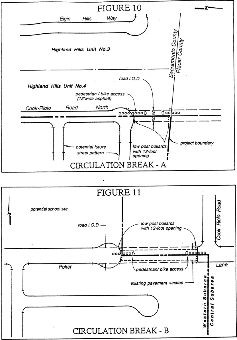
DESIGN CRITERIA-CIRCULATION
Section titled “DESIGN CRITERIA-CIRCULATION”-
Circulation breaks shall be incorporated at the following locations:
-
Cook-Riolo Road at the County Line - Break “A”
-
Poker Lane at Cook-Riolo Road - Break “B”
Design of these circulation breaks shall be consistent with features shown on Figures 10 and 11. Features include the following:
- Vertical curb at right-of-way or asphalt dike at entrances to circulation breaks.
- Low post bollards (6" x 6", 6-foot o.c. min.) along right-of-way on each side of path (no barricade to path).
- Streetlights at right-of-ways, and additional street lighting, if necessary, to. the satisfaction of the Sheriff's Department (1.5 footcandles minimum maintained along footpath).
- No parking and no access signage, and curb paint, at each path connection to right-of-way.
- Provide a maintenance entity for lighting and maintenance, road and fence repair, clean up including vandalism and waste debris, and enforcement of parking laws.
- Fifty-foot Irrevocable Offers of Dedication for potential future vehicular access.
- Provide adequate access to adjacent, existing developed properties along the circulation breaks.
-
-
Internal circulation within the urban-residential areas shall incorporate the following design measures.
- Street layouts shall conform to topography, drainage, and vegetation to the extent feasible.
- Street layouts shall provide multiple access routes within the subarea. Designs which create excessive through traffic within the subarea are discouraged.
- Access points along multi-lane arterial streets shall be restricted to locations approved by the County Transportation Division.
- Internal street layouts shall provide access to public facilities, including school, park, and open space areas.
- Internal streets adjacent to public facilities shall include the following design:
- School sites shall include minimum 30-foot half streets fronting on at least two sides where feasible.
- Park sites shall include street frontage on two sides where feasible, sufficient to provide adequate access from multiple directions.
- Circulation adjacent to drainage facilities shall include open cul-de-sacs, single-loaded linear streets, loop streets, or any combination on at least one side of the drainage facility. (This implements General Plan Conservation Element Policy CO-120.)
-
Subdivision designs shall extend existing, adjacent road stubs into the subdivision, such as Pearlstone Drive, Palmerson Drive to ensure adequate circulation between urban areas.
-
Subdivision maps with primary residential or collector streets with anticipated traffic volumes higher than normal should consider including special design treatments to minimize potential nuisance problems with adjacent residential lots. Examples include side-on lots, separated sidewalks, or special driveway designs.
PUBLIC FACILITIES
Section titled “PUBLIC FACILITIES”INTRODUCTION
Section titled “INTRODUCTION”This section describes the public facilities needed to serve land uses described in the East Antelope Specific Plan. Several sub-sections include conceptual master plans for particular public facilities within the Plan Area.
This section includes discussion on existing and future public facilities to the Central Subarea. Existing agricultural-residential land uses may continue to utilize existing facilities, such as individual well and septic systems. Ultimate urban land uses in the Central Subarea will require extension of public facilities from surrounding subareas. Provisions are included to size public facilities in the Northern and Western Subareas sufficient to serve future land uses in the Central Subarea. Detailed discussion of this subject is included in the following sub-sections.
For a detailed description of existing and planned facilities and associated calculations, see the Preliminary Technical Studies in the Appendix of this Plan. A brief discussion of financing and phasing of public facilities is found in the Implementation section of this Plan.
STORM DRAINAGE
Section titled “STORM DRAINAGE”The East Antelope Specific Plan Area includes portions of two separate drainage basins and is roughly separated into western and eastern basins by Cook-Riolo Road. The western drainage basin covers approximately 137 acres within the Plan Area and lies in the upstream portion of a larger 1,180 acre drainage basin commonly referred to as Antelope Basin ‘A’. The eastern drainage basin consists of approximately 526 acres within the Specific Plan Area and is part of a larger 1,250 acre drainage shed that feeds into Dry Creek in Placer County. Both drainage basins generally drain in a south-to-north direction within the Specific Plan boundary.
For detailed analysis of drainage within the Plan Area, see the Drainage Analysis portion of the Preliminary Technical Studies in the Appendix. A Conceptual Drainage Master Plan is shown as Figure 12.
FIGURE 12 - CONCEPTUAL DRAINAGE MASTER PLAN
Section titled “FIGURE 12 - CONCEPTUAL DRAINAGE MASTER PLAN”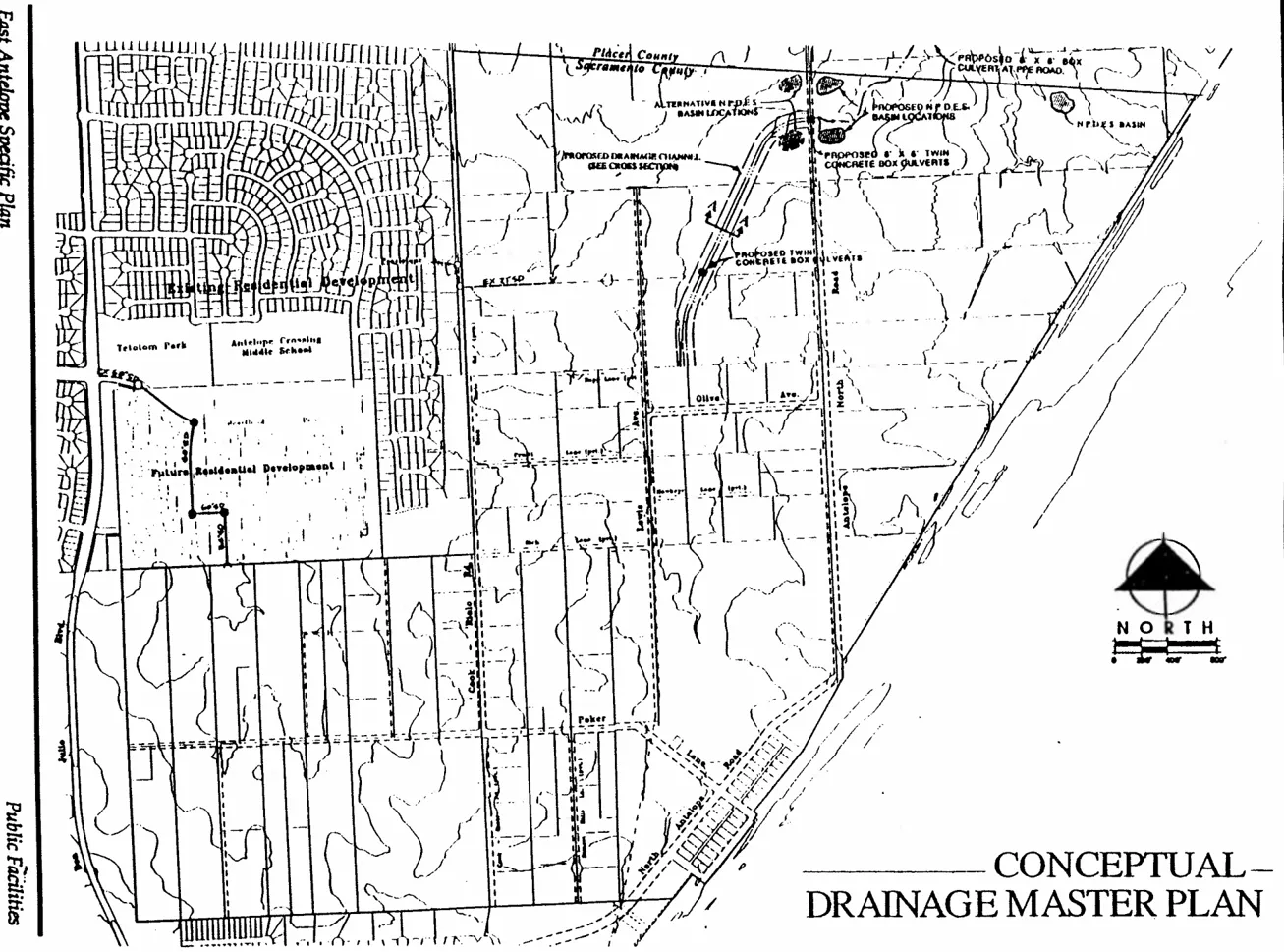
The Drainage Analysis shows that peak drainage flows in the western drainage shed can be accommodated by a piped drainage system. Drainage within the western shed will be collected via a piped system and connected to existing or planned facilities to the north. A Master Drainage Plan prepared for the adjacent D.O. Greens and Antelope Parkside projects includes a 54-inch pipe to be extended through these projects to the Antelope Parkside to a 60-inch drain pipe that exists in Heartland Drive (approximately 300 feet east of Don Julio Boulevard).
The eastern drainage basin includes the Northern, Eastern, and Central Subareas. Drainage from the Central Subarea will not change significantly since agricultural-residential land use (AR-1) will be maintained. Several road culvert crossings in the Central Subarea are not adequate to accommodate existing flood flows. Analysis of these crossings and any improvements are dependent upon future subdivisions or Parcel Map applications on adjacent properties. Drainage facilities downstream from the Central Subarea, such as the open channel and road crossings (described below), are sized to accommodate potential increases in storm drainage flows resulting from future increases in land use density in the Central Subarea.
Drainage within the Northern Subarea requires construction of a modified drainage channel to accommodate peak flood flows. This channel includes an approximate 30-foot bottom width, meandering low flow pilot channel, 3:1 side slopes, and 50-foot setback areas. This design traverses the Northern Subarea and terminates at Antelope North Road. One road crossing of the channel is included within the Northern Subarea and consists of a twin box culvert. This channel is sized to accommodate additional drainage flows from the Central Subarea should urban development occur. Channel design includes wetland vegetation in the channel bottom. This area is used for wetland creation to compensate for impacted wetlands in the Northern Subarea. Wetland issues are discussed in the Natural Resources section of this Plan. A 50-foot buffer area from edge of channel bottom to beyond top-of-bank is included in the channel design. Areas beyond the top-of-channel bank will be landscaped with native grasses and drought tolerant trees and shrubs and may include passive recreational use. (See Conceptual Channel Cross-Section, Figure 13.)
The Master Drainage Plan includes twin box culverts at the crossing of Antelope North Road and National Pollution Discharge Elimination System (NPDES) stormwater treatment facility on the east side of Antelope North Road. These settling basins treat urban stormwater runoff by detaining drainage flows to allow settling of contaminants, such as suspended solids and heavy metals (or other pollutants absorbed to those solids). The treated stormwater is then discharged into the natural stream channel. Drainage to the north in Placer County is via the existing, naturally defined channel. Improvement of the drainage crossing at P.F.E. Road is required to increase its capacity.
FIGURE 13: CONCEPTUAL CHANNEL SECTION
Section titled “FIGURE 13: CONCEPTUAL CHANNEL SECTION”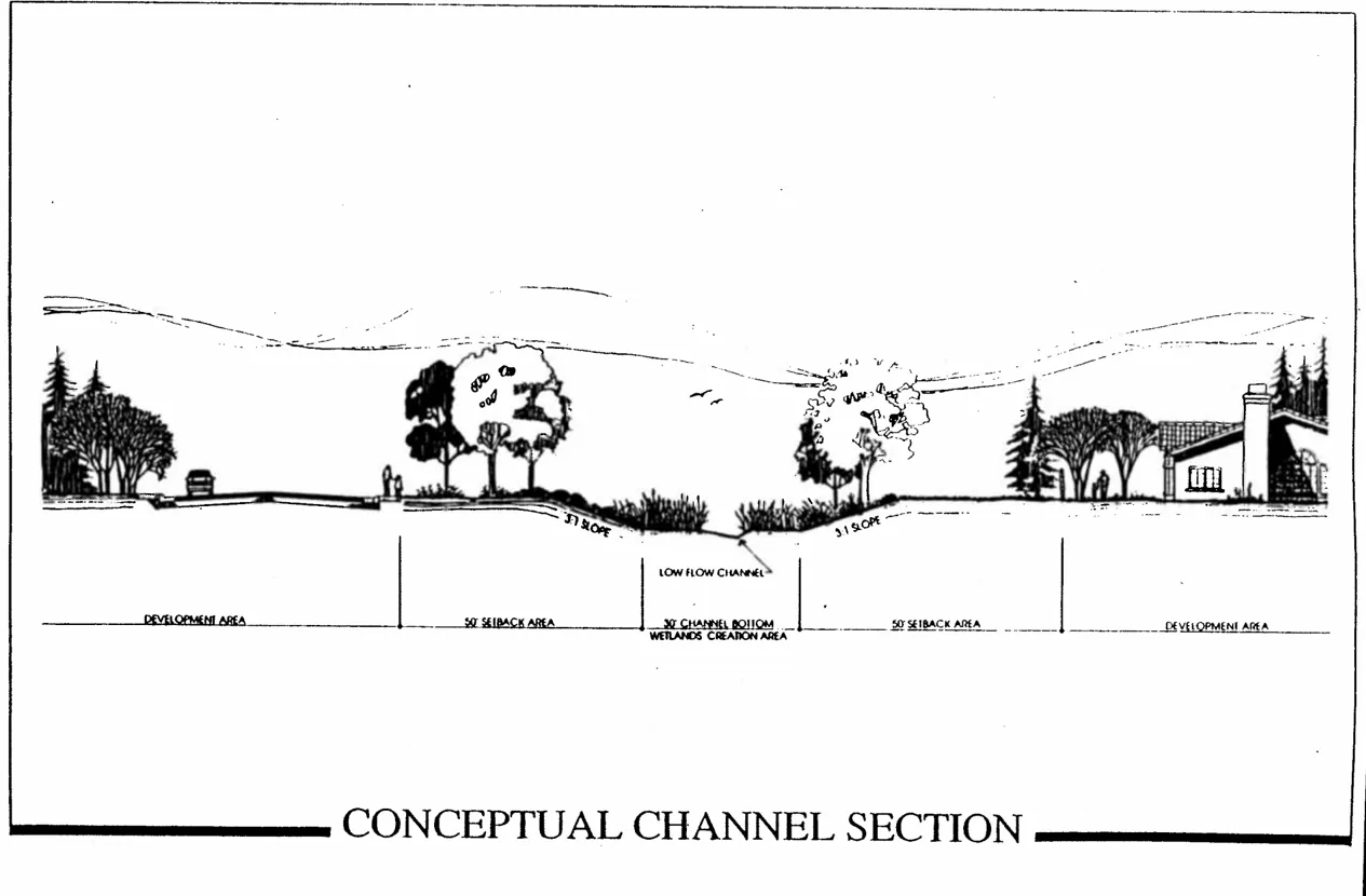
General Plan Conservation Element Policy CO-9 specifies the need for stormwater control strategies in Specific Plans. The NPDES facilities described above and included in the Master Drainage Plan is consistent with this policy.
SANITARY SEWER
Section titled “SANITARY SEWER”The Specific Plan Area obtains sanitary sewer service from the Sacramento Regional County Sanitation District. The Plan Area is currently within the Regional Sanitation District sphere of influence and annexation to the District is required.
The Regional Sanitation District sanitary sewer system includes large sewer interceptors throughout the urbanized portions of Sacramento County flowing to the Regional Wastewater Treatment Plant located near Freeport Boulevard. This plant has phased capacity through a series of expansions. Currently, the plant capacity is 300 million gallons per day (mgd). A plant expansion is underway to provide a capacity of 392 mgd; future expansions may be necessary.
A Conceptual Sewer Master Plan is included and shown as Figure 14. For additional detail, see the Sanitary Sewer Study in the Appendix section of this Plan. The Sanitary Sewer Study states that adequate capacity exists in adjacent, existing sewer trunk mains to provide service to land uses shown in the Specific Plan. This includes potential future urban land uses in the Central Subarea.
Sewer service within the Specific Plan Area divides the Western Subarea from the other subareas. An 18-inch trunk sewer exists at the street stub of Heartland Drive. This trunk is planned to extend through the future D.O. Greens and Antelope Parkside subdivisions. A 12-inch sewer line is planned to the Specific Plan boundary and is sized to carry approximately 1.0 mgd. Development within the Western Subarea will extend a sewer line across the subarea and stub at the southern plan boundary. A sewer lift station exists off-site in the Antelope Hills No. 5 subdivision. This station will be abandoned when the proposed sewer line is extended through the Western Subarea.
Sewer service to the Northern and Eastern Subareas is via an existing 15-inch sewer trunk that traverses the constructed Highland Hills project and stubs in Pearlstone Drive at Cook-Riolo Road. This trunk line is sized to carry approximately 2.3 mgd. The Northern Subarea system design includes gravity feed sewer mains to a low point at Antelope North Road and the County line. A lift station at the low point and force mains are necessary to carry sewer flows back to Cook-Riolo Road and connect to the existing 15-inch trunk main.
FIGURE 14: CONCEPTUAL SEWER MASTER PLAN
Section titled “FIGURE 14: CONCEPTUAL SEWER MASTER PLAN”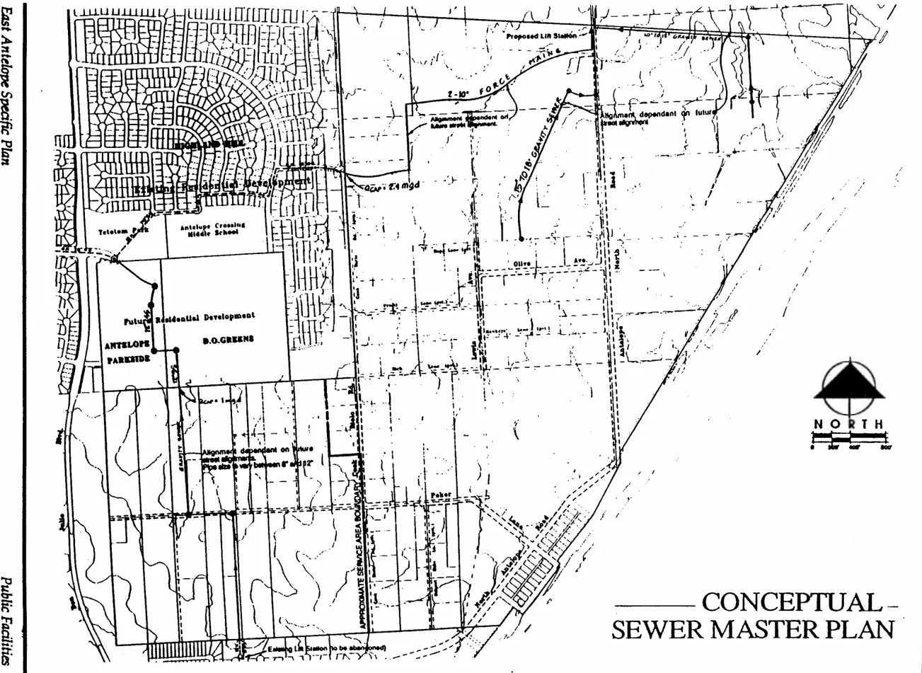
Individual septic systems currently provide service to industrial uses in the Eastern Subarea. Future industrial uses may utilize septic systems or public sewer depending on the land use and type of sewage flow. Individual septic systems shall be constructed subject to County Environmental Health Division requirements. Public sewer service to the Eastern Subarea requires construction of gravity flow sewer mains to the lift station described above. Phased expansion of the lift station and force mains will ensure adequate capacity for industrial uses if needed.
The Central Subarea is served by individual septic systems. It is anticipated that septic systems can continue to be utilized with AR-2 land use (subject to County Environmental Health Division requirements) since it is a continuation of the existing land use. AR-1 land use will require public sewer service as directed by County General Plan policies. Public sewer facilities could be extended from the Northern Subarea. Cost of such service extensions would be borne by AR-1 developments.
Any future urban land uses in the Central Subarea will require extension of public sewer facilities. Downstream facilities in the Northern Subarea have been sized or can be expanded to accommodate future urban land uses in the Central Subarea.
General Plan Land Use Element Policy LU-47 requires extension of public sewer (and water systems) to one- and two-acre lots in agricultural-residential areas. Public sewer is not proposed to serve the Central Subarea, although it may be required as part of individual AR-1 projects. The potential future urbanization of this area limits the desirability of sewer service to large agricultural-residential lots when another system may be needed to serve future, more dense development.
DOMESTIC WATER
Section titled “DOMESTIC WATER”The East Antelope Specific Plan is located within the Northridge Water District (NWD), which provides domestic water service to the southern Antelope area and extends to portions of Foothill Farms and Citrus Heights. Citizens Utilities does not serve the Specific Plan Area, but provides water service in the area to the south and northwest. For additional information on this subject, see the Water Distribution and Supply Analysis in the Appendix.
Water Demand
Section titled “Water Demand”The projected average daily water demand for the Specific Plan Area is approximately 1.44 million gallons per day (mgd). An average daily use of 1.44 mgd equates to a yearly demand of approximately 1,600 acre-feet for the Plan Area. This demand is consistent with the Northridge Water District Master Plan which projects the ultimate average daily water use for the entire Antelope area to be 3.5 mgd (without conservation). The 1.44 mgd demand from Specific Plan Area represents approximately 41% of the total projected NWD Antelope area demand, while the Plan Area comprises approximately 45% of the total NWD Antelope area acreage.
Water Supply
Section titled “Water Supply”Northridge Water District has relied on groundwater supplies throughout the District in the past. Future water supply will be provided through Northridge Water Districts (NWD) conjunctive use supply plan. NWD has contracted with San Juan Water District (SJWD) located to the east, to purchase 15.5 mgd of surface water supplied from Folsom Lake through its Peterson Treatment Plant and distributed through the planned cooperative transmission pipeline project to affiliated member water districts.
This surface water will be available for substantial portions of normal rain years. This surface supply will provide more than 100% of the NWD 2010 projected average daily demand for the months of October through March, and a substantial portion of the demand for additional months. During October through March, surface water supplies in excess of the demands will be available for groundwater recharge through existing NWD water wells. The combined effect on the groundwater aquifer during these periods of the year will be to generally eliminate the draw-down attributable to NWD pumping and to enhance the groundwater supply through recharge. During times of high demand and when this surface water supply is not available for purchase, NWD wells will be utilized to extract the restored groundwater.
General Plan Policies CO-20 and CO-21 require that a Master Plan for water supply be adopted by the Board of Supervisors and all agreements and financing for supplemental water supplies be in place prior to urban land use entitlements being granted. The East Antelope Specific Plan Water Master Plan provides specific information as to the agreements and financing which are in place to provide supplemental water supplies for not only this area, but the entire Northridge Water District. Adoption of this Water Master Plan as part of this Specific Plan process therefor satisfies General Plan Policy CO-20 and CO-21.
Existing Facilities
Section titled “Existing Facilities”Existing facilities include a water well field (three wells) in the Central Subarea on the north side of Poker Lane. One of the wells is developed at this time. A 12-inch water main extends from the well field west along Poker Lane to Don Julio Boulevard, then south to Antelope Road, eventually connecting with the Northridge water distribution system to the south. A 12-inch main runs north in Cook-Riolo Road to the existing Antelope Estates project.
Proposed Facilities
Section titled “Proposed Facilities”Water supply facilities planned to serve the immediate Specific Plan Area include a grid of 12-inch water mains on approximately 1,300-foot spacing. This includes planned water mains in Cook-Riolo Road, Lewis Avenue, and Antelope North Road with appropriately spaced cross connections. (The Lewis Avenue main will provide water service access to existing lots in the Central Subarea.) Two additional production wells are indicated in the Northridge Master Plan. These wells will be located in the Northern and Eastern Subareas respectively. (See Conceptual Water Distribution Master Plan, Figure 15.) Plans also include enhancements to the Poker Lane wells and emergency interties with nearby Citizens Utilities facilities.
Additional facilities planned within the Specific Plan Area to serve district-wide needs include a three million gallon storage tank and pumping facility near the southwest corner of the Western Subarea, and a 42-inch transmission main along the full length of Poker Lane. This main is part of a district-wide conveyance pipeline that extends east and connects with a San Juan Water District pipeline to provide a surface water supply from Folsom Reservoir. An alternative storage tank site is located immediately southwest of the Specific Plan Area and may be pursued by NWD. (See East Antelope Specific Plan Water Master Plan.)
DRY UTILITIES
Section titled “DRY UTILITIES”Electrical: The East Antelope Specific Plan is located within the Sacramento Municipal Utility District (SMUD). Existing facilities include a 230 kv transmission line along the southern and western Specific Plan boundaries, and a 69 kv line along Poker Lane and north along Don Julio Boulevard. A SMUD substation exists near the northwest corner of the Specific Plan Area along Don Julio Boulevard. Overhead 12 kv service lines traverse the Plan Area, and underground 12 kv lines exist in the adjacent Highland Hills subdivision. New electrical service will be via underground 12 kv service lines constructed concurrently with subdivision development. Presence of the 69 kv line and nearby substation insures no electrical load problems for development within the Specific Plan Area.
FIGURE 15: CONCEPTUAL WATER DISTRIBUTION MASTER PLAN
Section titled “FIGURE 15: CONCEPTUAL WATER DISTRIBUTION MASTER PLAN”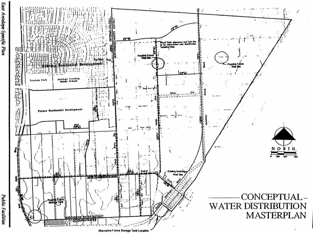
Natural Gas: The Specific Plan Area is within the Pacific Gas & Electrical service area for natural gas. A 12-inch high pressure gas transmission main runs along Lewis Avenue from Placer County, crosses the Eastern portion of Poker Lane, and exits the Plan Area to the south near Antelope North Road. A system of 2- and 4-inch gas lines tap off the high pressure line and provide natural gas service to portions of the Specific Plan Area. The 12-inch high pressure transmissions line is constructed at a shallow depth and will require realignment through the Northern Subarea. Options include realignment within subdivision streets or east to Antelope North Road. Domestic service within the Plan Area can be accommodated through construction of 4-inch service lines (tapping off the high pressure line if necessary) concurrent with subdivision development.
Telephone: Service to the Specific Plan Area is provided by Roseville Telephone. Existing service is via overhead lines throughout the area. An underground vault (switch) was recently constructed on the east side of Antelope North Road at the Southern tip of the Eastern Subarea. Future telephone service will be via a combination of overhead and underground lines. Extension of facilities is constructed by Roseville Telephone. Service lines within residential subdivisions are installed concurrently with joint utility trench construction.
Cable: Both Sacramento Cable and PacWest Cable provide cable television service to the area. Sacramento Cable has facilities in the adjacent residential subdivisions. Service involves underground extension of service lines within a joint utility trench. Service by PacWest is via microwave transmission with receiver dishes, thus no facility construction is needed.
ELEMENTARY SCHOOL
Section titled “ELEMENTARY SCHOOL”The East Antelope Specific Plan is located within the Dry Creek Joint Elementary School District, which provides K-8 education. The Plan Area is located in the southwestern corner of the school district; Walerga Road and Antelope Road are the western and southern district boundaries. The District has several schools in the area. The Dry Creek Elementary School is located at P.F.E. Road and Cook-Riolo Road and was deeded to the district in 1887. This site also contains district offices. The newly constructed Antelope Meadows Elementary School is located approximately one mile west on North Loop Road and opened in fall 1992. The Antelope Crossing Middle School is one-quarter mile west at Heartland Drive and Palmerson Drive. This school opened in fall 1994. One unnamed elementary school is planned on the Barrett property approximately one-half mile west along the future extension of Elverta Road.
Development within the Specific Plan Area will generate the need for both elementary and middle school facilities. Student yield factors for single family are 0.386 and 0.114 students per unit for elementary and middle schools respectively. A total of 1,436 residential units in the Northern and Western Subareas gives a yield of 554 elementary school students and 164 middle school students. The Land Use Plan includes a 10.0± acre elementary school site at Poker Lane and the extension of Palmerson Drive and can accommodate the anticipated elementary student yield. Due to concerns of existing residences located on the proposed elementary school site, the site may be relocated within the Western Subarea. Any relocation will be subject to State and Dry Creek School District siting criteria and will be addressed with the submittal of tentative maps in the Western Subarea. Middle school students would attend the nearby Antelope Crossing Middle School. Original design of the middle school did not anticipate significant student yield from the Specific Plan Area. Modifications to the Antelope Crossing Middle School may be necessary to accommodate the additional middle school students, since a second middle school facility is not warranted.
Public Facilities Element Policy PF-38 requires that Specific Plans show the location of future school sites and provide funding for acquisition. The discussion above describes reservation of school sites. Funding for acquisition by the school district is briefly described in the Implementation Section of this Plan.
The Specific Plan Area is immediately adjacent to the Dry Creek Joint Elementary School District Community Facilities District No. 1. This district covers portions of the Antelope Community Plan and includes a Mello-Roos Financing Plan for construction Of school facilities in the Antelope area. Since student generation from the Specific Plan Area will impact Facility District programs, the Plan Area should annex into Community Facilities District No. 1.
HIGH SCHOOL
Section titled “HIGH SCHOOL”The Plan Area is located within the Roseville Joint Union High School District. The District boundaries continue south to Antelope Road and west to Walerga Road. Existing high schools in the area include the Roseville High School, located in downtown Roseville, and the Woodcreek Oaks High School, located at Junction Boulevard and Cook-Riolo Road in the northwest portion of Roseville. This facility Opened in Fall 1994. The need for an additional high school site in the area has been identified by the school district. This high school is planned for Southern Placer County Or Antelope area; however, an exact location has not been determined. Construction of the new high school is anticipated around year 2000 and would serve students generated from the Specific Plan Area.
High school student yield factor for single-family residential is 0.1909 students per unit. A total of 1,436 residential units planned in the Northern and Western Subareas gives a yield of 274 high school students. Students would be served by the Woodcreek Oaks High School until a new facility is constructed closer to the Specific Plan Area.
The Specific Plan Area is served by the Sunrise Recreation and Park District. This district provides park and recreation services for a large portion of Citrus Heights and the Antelope Community Plan.
Several nearby park sites are planned as part of the Antelope Community Plan. Tetotom Neighborhood Park is approximately 11 acres in size and located 1/3 mile west (next to Antelope Crossing Middle School). Tetotom Park was constructed in 1994. The 40± acre Antelope Community Park is planned approximately 1 mile west, just off Elverta Road. This community park will serve as a core facility for the Antelope area. Scheduling of construction is uncertain. Finally, a 4.6 acre park site is located immediately to the south of the Specific Plan boundary along the north side of Antelope North Road. This site is undeveloped; timing of construction is uncertain.
The Sunrise Recreation and Park District desires two neighborhood parks in the Specific Plan Area; one each in the Northern and Western Subarea. This is intended to maximize efficiency of park development and long term maintenance costs while still providing proximate parklands for each subarea. Based upon parkland dedication factors and maximum allowable dwelling units, 6.7± and 7.2t acre park sites are planned for the Northern and Western Subareas. Ultimate acreage of park sites may vary based upon the actual number of residential units requested by individual development applications. These park facilities would serve as neighborhood parks for the urban-residential areas.
The following describes the planned park sites in more detail.
Western Park Site: This 7.2± acre site is located next to the planned elementary school and is intended to be developed with the Dry Creek Elementary School District as a joint use facility. Combining use of play fields, hard courts, and multi-purpose buildings results in greater efficiency. The park is located along existing Poker Lane and the extension of Palmerson Drive and is located to serve on the proposed site and potential relocation of the school site. The park site may be relocated due to existing residences on the proposed site and potential relocation of the school site. Any relocation will be subject to Sunrise Recreation and Park District review and will be addressed via tentative maps filed in the Western Subarea.
Northern Park Site: This site is located along Antelope North Road and contains a grove of oak trees. Configuration of this neighborhood park is defined by layout of the Parkway Greens Tentative Map. The adjacent one-acre industrial parcel (Sadro) may be acquired in the future to complete the park configuration.
Conceptual Master Plans for these park sites are included as Figures 16 and 17. These plans are intended to illustrate a possible layout for park facilities within each park site and may substitute for the Park Site Master Plan process by Sunrise Recreation and Park District. Any relocation of the Western park site will require a revised Conceptual Master Plan which can be incorporated administratively when a decision is made to relocate the park.
Development within the East Antelope Specific Plan will require either dedication of parkland or payment of In-Lieu Fees per Sacramento County Title 22 requirements. In addition, cost of developing a portion of the park sites will be via a Park Development Fee charged on building permits similar to the Antelope Public Facilities Financing Plan. Development of turn-key parks is encouraged when feasible. When an individual development project is processed, it may be possible to advance development of the park site concurrent with development of the surrounding subdivision. Under a turn-key arrangement, a subdivider may agree to construct park frontage, perform grading on the park site, and install irrigation, turf, landscaping and possibly other park site improvements. Any improvements by subdivider must be consistent with the Conceptual Master Pian for that park site. Cost of these improvements by subdivider would be credited against Park Development Fees that would otherwise be paid. If turn-key park development is pursued, an agreement should be reached between the subdivider and the Sunrise Recreation and Park District, establishing such things as schedules, cost of improvements, construction standards, and procedures for review and acceptance of improvements.
JOINT USE FACILITIES
Section titled “JOINT USE FACILITIES”The County Board of Supervisors has established a policy of developing joint use public facilities. Joint use involves the shared use, to the greatest extent possible, of land capital facilities, capital costs, operation/maintenance costs, staff, and programming responsibilities among respective jurisdictions. The joint use concept is not intended as a means to reduce public services. Instead, joint use should make public services more efficient.
FIGURE 16: CONCEPTUAL MASTER PLAN WESTERN PARK SITE
Section titled “FIGURE 16: CONCEPTUAL MASTER PLAN WESTERN PARK SITE”
FIGURE 17: CONCEPTUAL MASTER PLAN NORTHERN PARK SITE
Section titled “FIGURE 17: CONCEPTUAL MASTER PLAN NORTHERN PARK SITE”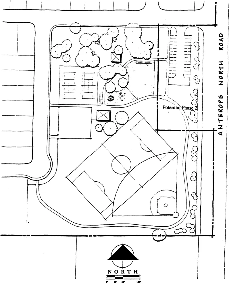
The East Antelope Specific Plan includes a school/ park facility in the Western Subarea. This design creates the potential for joint use agreement between the Dry Creek Elementary School District and the Sunrise Recreation and Park District. Such an agreement is in place at the Antelope Middle School/ Tetotem Park site one-quarter mile to the west. Park sites and stormwater detention basins within the Specific Plan are located separately to best serve the Plan Area and do not permit joint use. No community centers, libraries, or fire stations are planned for this area. The greatest potential for joint use facilities is with potential future core land uses in the Central Subarea.
POLICIES -PUBLIC FACILITIES
Section titled “POLICIES -PUBLIC FACILITIES”General
Section titled “General”- Development projects shall participate in the cost of constructing master infrastructure facilities. Determination of fair share costs, timing, and funding mechanisms for master infrastructure facilities shall be determined by the adoption of a Financing Plan for this Specific Plan.
- Timing of public facilities to serve existing agricultural-residential land uses in Central Subarea shall be determined by development applications within the Central Subarea.
- Design of public facilities within urban-residential areas shall be sized, or provide for future expansion, to accommodate potential urban land uses in the Central Subarea.
- Extensions of public facilities to urban-residential areas should provide the opportunity for use by existing Agricultural-Residential land uses where practical.
- Financing of public facilities should be designed to provide timely delivery of services to new development areas.
- Joint use of new public facilities within the Plan Area should be examined and utilized to the greatest extent possible.
Drainage
Section titled “Drainage”- The Conceptual Drainage Master Plan contained within this Specific Plan shall be considered the Drainage Master Plan for the basin.
- Land use entitlements granted for future projects within the Eastern drainage shed shall be conditioned to pay a fair share contribution for basin specific drainage mitigation in Placer County and urban stormwater quality facilities. Such fair share may be replaced by the future update of County Zone 11 drainage fees for this area. Such future land use entitlements shall also be conditioned to pay the drainage fee as identified in the Placer County Dry Creek Watershed Flood Control Plan, as adopted by the Board of Supervisors. Projects within the Western drainage shed which are within the existing Antelope Draiange Basin A shall pay Antelope Drainage Basin A fees as defined in the Public Facilities Financing Plan.
- Development within the East Antelope Specific Plan shall prevent permanent damage to the groundwater supply consistent with the intent of policies CO24A and CO-24 of the County General Plan.
- Development of water supply facilities shall be consistent with the Northridge Water District Master Plan.
- Conceptual Development Plans contained within this Specific Plan are considered the Park Site Master Plans by the Sunrise Recreation & Park District. Future changes to the Park Site Master Plans may be made only by Sunrise Recreation & Park District.
- Accelerated, or “turn-key’, development of park sites should be pursued with developers, if possible.
- A 7.2± acre net park site shall be located within the Western Subarea. The Land Use Plan shows the proposed park site located at the intersection of Palmerson Drive and Poker Lane. Detailed evaluation of this site shall occur concurrent with filing of a tentative map (or maps) in the Western Subarea. If the proposed park site within the Western Subarea shall be proposed by the tentative map applicant and found acceptable to the Sunrise Recreation and Park District. In this case, documentation shall be provided to the County Planning Department as to the alternative park site. However, no amendment to the Specific Plan Land Use Plan is required.
DEVELOPMENT REGULATIONS-PUBLIC FACILITIES
Section titled “DEVELOPMENT REGULATIONS-PUBLIC FACILITIES”General
Section titled “General”- Master infrastructure facilities necessary to meet immediate needs shall be developed prior to, or concurrently with, individual development projects as identified in the Financing Plan.
- Off-site public facilities may be required for an individual development project. If necessary, Sacramento County may assist in the acquisition of property rights for off-site public facilities pursuant to the State Subdivision Map Act.
Drainage
Section titled “Drainage”- Construction of the proposed drainage channel and NPDES Basins in the Northern and Eastern Subareas shall be consistent with the Conceptual Drainage Master Plan and Channel Cross-Section contained within this Specific Plan. The Conceptual Channel section (Figure 14) is preliminary and is subject to final design and approval by Water Resources Division. These facilities may be phased, depending on the timing of residential development, as approved by the Sacramento County Water Resources Division.
- Interim drainage and NPDES treatment facilities may be constructed with upstream development projects subject to approval of Sacramento County Water Resources Division.
- Drainage facilities in the Central Subarea shall be planned and developed concurrently with individual development projects in that Subarea based upon adopted agricultural-residential land use.
- Construction of public sewer facilities shall be consistent with the Conceptual Master Plan contained within this Specific Plan and as described below:
- Sewer service to the Northern Subarea shall include construction of an expandable lift station and force mains as a master infrastructure facility. Interim sewer facilities may be constructed subject to approval of Sacramento County Water Quality Division.
- Sewer service to the Eastern Subarea may utilize individual septic systems if feasible and consistent with the proposed use. If public sewer service is necessary, development shall connect to and expand the lift station and force mains described in Sub-Paragraph (a).
- AR-2 development in the Central Subarea may continue to utilize individual septic systems. Public sewer service shall be required for AR-1 development and service shall be extended by individual development projects and/or property owners in the Central Subarea. Any future urban land uses in the Central Subarea will require extension of public sewer facilities.
- Individual development projects in the Northern and Western Subareas shall extend Northridge Water District facilities sufficient to provide adequate water service in accordance with the Water Distribution Plan contained within this Specific Plan.
- New domestic water service to the Central Subarea shall consist of extensions from existing Northridge Water District facilities, or from water main extensions to the Northern or Western Subareas. New domestic water service shall be the responsibility of development and/or property owners within the Central Subarea.
Dry Utilities
Section titled “Dry Utilities”- Extension of dry utilities (including electric, gas, telephone, and cable) shall be coordinated with the service providers concurrently with Improvement Plan review of individual development projects.
- The 12-inch high pressure gas transmission main within the Northern and Central Subareas may be relocated or otherwise protected to the satisfaction of Pacific Gas & Electric concurrently with individual development projects.
Schools / Parks
Section titled “Schools / Parks”-
The elementary school site located in the Western Subarea shall be reserved for acquisition by the Dry Creek Joint Elementary School District.
To the extent that the park sites in the Western and Northern Subareas are not dedicated under the Quimby Act, they shall be reserved for acquisition by the Sunrise Recreation and Park District.
-
Measures to accelerate park site development should be pursued where possible. Measures include, but are not limited to: advanced dedication or right of use for parkland with credit toward future development, construction of minimum park site improvements (i.e., turf and irrigation) by developer concurrently with subdivision improvement, and credit for park site construction costs toward land dedication or Park Development Fee requirements.
-
A 10.0± acre net school site shall be located within the western subarea. The Land Use Plan shows the proposed school site located along the extension of Palmerson Drive. This location must meet school siting criteria as established by the State. Detailed evaluation of this site shall occur concurrent with filing of a Tentative Map (or maps) in the western subarea. If the proposed school site is not acceptable to the Dry Creek School District, an alternative school site within the western subarea shall be proposed by the Tentative Map applicant and shall be found acceptable to the Dry Creek School District. In this case, documentation shall be provided to the County Planning Department as to the alternative school site; however, no amendment to the Specific Plan Land Use is required.” Dry Creek School District shall not incur costs of condemnation of the school site unless reimbursed by the Tentative Map Applicant or State Aid Building Fund.”
NATURAL RESOURCES
Section titled “NATURAL RESOURCES”OVERVIEW
Section titled “OVERVIEW”The East Antelope Specific Plan Area is located on the relatively flat floor of the Sacramento Valley, approximately fifteen miles west of the Sierra Nevada, and forty miles east of the North Coast Range. Plant communities include oak/savannah grassland; orchard, and occasional riparian corridors. The annual grasslands are regularly disturbed and are dominated by non-native species. Valley oak, blue oak, and interior live oak occur in the area, primarily as specimen trees scattered throughout the Plan Area. Two oak tree clusters exist along drainage courses at the north portion of the Eastern Subarea. Several almond and olive orchards exist in the area. These are well established orchards with areas in decline or abandonment. Areas of existing agricultural-residential land use have sparse to substantial ornamental landscaping.
WETLANDS
Section titled “WETLANDS”There are at least four types of wetlands found within the East Antelope Specific Plan: seasonal wetland, freshwater marsh, intermittent drainage, and stock pond. Vernal pools have not been verified on the site; however, it is possible that a few may occur in Plan Area which impacts wetlands may be subject to a permit by the U.S. Army Corps of Engineers, as well as the jurisdiction of other federal and state agencies. Requirements which are imposed by the Corps of Engineers are intended to mitigate for the loss of wetlands due to development. A policy of no net loss of wetlands applies to this Plan, ensuring consistency with General Plan Policies CO-62 and CO-83.
A preliminary wetland inventory has been conducted for the Specific Plan Area based on a combination of on-site reconnaissance and aerial photograph interpretation. A breakdown of wetland types by subarea is shown as Table 4. The Planning Area contains mostly seasonal wetland and intermittent drainage. Seasonal wetlands are associated with broad flat swales that provide localized drainage within the Plan Area. Intermittent drainage wetlands are characterized by a cut channel, such as in the Eastern drainage shed. These channels carry significant drainage flows during the wet season, but are dry during the summer. A small area of freshwater marsh exists in the Northern Subarea and is associated with a small impoundment along the existing drainage way. Small stock ponds are scattered throughout the Plan Area; most are for ornamental purposes and are not considered jurisdictional wetlands by the Corps of Engineers. Overall, wetlands within the Specific Plan Area are of low habitat value because of the small size and limited distribution, and disturbance through historic and ongoing land use practices.
TABLE 4
Section titled “TABLE 4”| Wetland Classification | Existing Acreage | Northern Subarea | Central Subarea | Eastern Subarea | Western Subarea |
|---|---|---|---|---|---|
| Seasonal Wetland | 3.30± | 1.02± | 0.7± | 0.9± | 0.7± |
| Freshwater Marsh | 0.47± | 0.47± | 0.0± | 0.0± | 0.0± |
| Intermittent Drainage | 3.80± | 0.14± | 1.7± | 2.0± | 0.0± |
| Stock Pond | 0.50± | 0.08± | 0.1± | 0.0± | 0.3± |
| Total | 8.10± | 1.71± | 2.5± | 2.9± | 1.0± |
*Subject to Corps verification
Future development within the Northern and Western Subareas are presumed to impact existing wetlands. Development within the Central Subarea is less likely to impact wetlands through the planning of larger agricultural-residential lots. Eastern Subarea development is presumed to avoid wetland impacts mainly because of the limited industrial development activity currently associated with the existing parcelization.
Several wetland strategies are available for development within the Northern and Western Subareas, including avoidance, on-site mitigation within the Specific Plan Area, off-site mitigation, and mitigation banking or payment of fees. In the Northern Subarea, the proposed open drainage channel will provide areas along the channel corridor for creation of compensation wetlands. Design of the channel has been widened to provide a minimum 30-foot bottom width. This will create an area of 1.6± acres which would mitigate for the 1.6± acres of wetlands anticipated to be impacted within the Northern Subarea.
The Western Subarea does not contain a proposed channel; therefore, no water course-related site within the subarea exists for mitigation. Other options include avoidance, off-site mitigation, mitigation banking, and the payment of fees. Wetlands in the Western Subarea are mostly seasonal wetlands, including a minor complex of broad swales on the north side of Poker Lane. Avoidance of this area may not be practical due to the irregular and sprawling pattern of the wetlands. Also, preserved wetlands. surrounded by urban development, in many cases, lose a substantial amount of their habitat value. More feasible wetland strategies in the Western Subarea include off-site mitigation, mitigation banking, and payment of fees. With recent development adjacent to the Plan Area and the County line acting as the Plan Area’s Northern boundary, there is potential to locate a mitigation site(s) nearby in Placer County. Without a defined Wetland Mitigation Plan available at this time, development within the Western Subarea which impacts wetlands shall develop a wetland mitigation proposal for consideration concurrently with individual development application(s).
SPECIAL-STATUS SPECIES
Section titled “SPECIAL-STATUS SPECIES”A special-status species assessment was conducted for the Specific Plan Area using a combination of site visits when property was accessible and computer data base research. The assessment was conducted to determine the potential for presence or absence of special-status species in the Specific Plan Area. The “special-status species” definition includes both listed and candidate species under federal and California Endangered Species Acts, and other designations by the California Department of Fish & Game.
The assessment concludes that the six habitat types within the Plan Area (seasonal, wetlands, intermittent drainage, freshwater marsh, artificial wetlands, disturbed annual grassland, and orchards) may be utilized by as many as thirty-eight regionally occurring special-status species. Only five potentially occurring special-status species are listed as ‘rare’, ‘threatened’, or ‘endangered’ by either the California Department of Fish & Game or U.S. Fish & Wildlife Service. These include Boggs Lake hedge-hyssop, Sacramento orcutt grass, slender orcutt grass, giant garter snake, and Swainson’s Hawk.
An on-site inventory for special-status species was conducted for the Northern Subarea. This included several site visits during appropriate times of the year. No special-status species were observed in the Northern Subarea. No on-site surveys were conducted for the remaining Specific Plan Area. Instead, the remaining area was visited from roads and other publicly accessible areas. Based on these visits and knowledge of the area, it has been determined that the potential existence of special-status species in the Western, Central, and Eastern Subareas is low. However, on-site inventories may be required for individual development projects where substantial habitat exists to support special-status species.
OAK TREES
Section titled “OAK TREES”Oak trees are scattered throughout the Plan Area and include large specimens of valley oak and blue oak. Two significant clusters of oak trees exist along drainage courses at the Northern portion of the Eastern Subarea and are dominated by interior live oak. These clusters continue into Placer County up to P.F.E. Road.
Development within the Northern and Western Subareas may impact oak trees because of the proposed density. Development within the Eastern and Central Subarea can avoid many oak trees because of the large acreages involved. It is the intent of this Plan to protect oak trees whenever possible. Oak trees preserved within urban areas must be of sufficient health (as determined by the arborist) and have adequate protection measures to ensure long-term existence. Individual development projects which may impact oak trees must have an arborist report prepared with recommendations for each described below should be implemented. In some cases, preservation of an oak tree may substantially affect design of the project, for example, resulting in excessive slopes between lots or undesirable street grades. Removal of oak trees is allowed provided that sufficient justification can be demonstrated and mitigation is proposed and approved by the County.
Review of development around oak trees occurs at several levels. Arborist reports are prepared and mitigation measures are imposed at the tentative map review stage. Subdivision design and implementation of mitigation measures occurs at Final Map and Improvement Plan stage. In some cases, detailed review of lot and house design occurs with a Development Plan Review. However, detailed Development Plan Review may not always be necessary. If an “oak tree lot” is reviewed through the Subdivision Map process and constructed per approved Improvement Plans, subsequent building permits can be issued without the need for a Development Plan Review if proposed buildings avoid oak tree driplines. If peculiarities exist with an oak tree lot, then Development Plan Review may be needed.
POLICIES - NATURAL RESOURCES
Section titled “POLICIES - NATURAL RESOURCES”- Impacts to wetlands within the Northern Subarea shall be mitigated through the construction of an on-site drainage channel and associated wetland habitat. Design of the channel shall comply with requirements of permitting authorities, and included in a Drainage Master Plan approved by Sacramento County. Sacramento County shall be the permittee for any Army Corps of Engineers or State Department Fish & Game Permits required for the channel project.
- Individual development projects that impact wetlands in the Western Subarea shall include a wetland mitigation proposal to be considered with the development application. Permits which may be required shall be obtained by the project applicant.
- Development in the Central and Eastern Subareas that impact wetlands shall obtain necessary permits prior to construction.
- Individual development projects which are determined to have a high potential to contain special-status species habitat shall have an assessment conducted by a qualified biologist.
DEVELOPMENT REGULATIONS - NATURAL RESOURCES
Section titled “DEVELOPMENT REGULATIONS - NATURAL RESOURCES”- Individual development projects, which include oak trees 6-inch dbh or larger, shall comply with the following measures:
- An arborist report shall be prepared for the individual developments and included in the project application. The report shall include a description of oak tree condition and recommendations.
- Following review of the individual development application by the County Planning and Community Development Department, requirements shall be placed on the project which require oak tree preservation and include appropriate protection measures, or allow tree removal, with mitigation when justified. Oak. tree removal required because of poor health or the construction of arterial roadways shall not require mitigation.
- Improvement Plans for individual development projects shall implement measures to preserve oak trees. Final Maps may include easements or other restrictions to ensure preservation of oak trees.
- If building permits are filed for lots with preserved oak trees and required mitigation measures are implemented through construction of the subdivision lots, then building permits shall be reviewed by the County Planning and Community Development Department as part of the plan check process. If peculiarities exist on lots with oak trees, then Development Plan Review by the County Planning and Community Development Department shall be required.
- Oak trees to be retained within the Specific Plan Area shall be preserved and protected using the following methods:
- A circle with a radius measurement from the trunk of the tree to the tip of the longest limb shall constitute the dripline protection area of each tree, and must not be cut back in order to change the dripline. The area beneath the dripline is a critical portion of the root zone and defines the minimum protected area of each tree. Removing limbs which make up the dripline does not change the protected zones.
- All oak trees and other trees on the site that require pruning shall be pruned prior to grading the site. Oak trees which will require major pruning (branches larger than two [2"] inches in diameter) shall be trimmed by a certified arborist or other professional tree expert.
- Chain link fencing or a similar protective barrier shall be installed one foot outside the driplines of the oak trees prior to initiating project construction in order to avoid damage to the trees and their root systems. No construction activities shall be allowed within the fenced areas.
- No signs, ropes, cables, or any other items shall be attached to the oak trees.
- No vehicles, construction equipment, mobile home/office, supplies, materials, or facilities shall be driven, parked, stockpiled, or located within the driplines of oak trees.
- No grading whatsoever shall be allowed within the driplines of oak trees.
- No trenching shall be allowed within the driplines of oak trees. If it is absolutely necessary to install underground utilities within the dripline of an oak tree, the utility line shall be either bored or drilled under the supervision of a certified arborist or other professional tree expert.
- Impervious surfaces shall not be allowed within the driplines of oaks.
- Landscaping beneath oak trees may include non-plant material, such as boulders, cobbles, wood chips, etc. The only plant species which shall be planted within the driplines of oak trees are those which are tolerant of the natural semi-arid environs of the trees. A list of drought-tolerant plant species is included as Attachment of the Initial Study. Limited drip irrigation approximately twice per summer is recommended for the understory plants.
- No sprinkler system shall be installed such that it irrigates the ground within the driplines of oak trees."
6. IMPLEMENTATION
Section titled “6. IMPLEMENTATION”This section provides discussion on enforcement of land use regulations, funding of capital improvements, and phasing of development improvements within the Specific Plan.
LAND USE REGULATION
Section titled “LAND USE REGULATION”Zoning Ordinance: Development within the Specific Plan Area is subject to requirements of the Sacramento County Zoning Ordinance except where superseded by adoption of an ordinance amendment related to this Specific Plan. Enforcement of zoning ordinance requirements occurs through review of Development Permits and ongoing administration enforcement.
Specific Plan: This Specific Plan contains detailed land use policies, development regulations, and design criteria that regulate development within the Specific Plan boundaries. These regulations are implemented through review of individual development applications for compliance with Specific Plan requirements.
Mitigation Monitoring: Chapter 20.02 of the Sacramento Code provides for monitoring and reporting of mitigation measures implemented through the CEQA environmental review process. This program is administered by the County Department of Environmental Review and Assessment (DERA) via Mitigation Monitoring and Reporting Programs (MMRP’s). Mitigation monitoring typically involves the reporting of completed mitigation measures to the County and verification by DERA. Mitigation monitoring relates to environmental mitigation measures, such as noise mitigation or development fees or design review, are not included in the Mitigation Monitoring and Reporting Program.
A Mitigation Monitoring and Reporting Program was prepared for this Specific Plan and is included in the Appendix. The Specific Plan MMRP includes monitoring of mitigation measures that apply throughout the Specific Plan area. More detailed development projects such as tentative maps and rezones.
CC&R’s: It is typical of residential development to create private CC&R’s for property within a project. These CC&R’s are privately regulated (Sacramento County has no jurisdiction) and control the use and maintenance of private properties to avoid nuisance. They also may include an architectural control committee, usually designated as the developer, that controls the configuration and design of house elevations and colors.
PUBLIC FACILITY FINANCING
Section titled “PUBLIC FACILITY FINANCING”Public facilities will be provided within the Specific Plan Area through a variety of financing mechanisms and are summarized below. For additional information on public facility financing, see the Conceptual Financing Plan included in the Appendix of this Specific Plan. Actions necessary to establish these financing mechanisms occur separately from adoption of this Specific Plan.
Generally, public facility financing will occur either through existing, County-wide mechanisms (such as water, sewer, and drainage) or via annexation to the existing Antelope Public Facilities Financing Plan (major roadways, parks, and fire). The Eastern Subarea will not be annexed to the Antelope Public Facilities Financing Plan, but will instead be subject to County-wide financing programs. This is due to the limited area of undeveloped, industrial land in the Eastern Subarea and the relatively few DUE’s (dwelling unit equivalents) that would be generated by industrial development.
General Plan Land Use Element Policy LU-8 requires an Infrastructure Financing Plan to be approved prior to approval of zoning for individual development projects. Approval of the East Antelope Public Facilities Financing Plan and Capital Improvement Program subsequent to adoption of the Specific Plan is consistent with General Plan Policy, provided that Zoning Agreements and tentative maps do not receive final approval until after approval of the Financing Plan and CIP.
Streets: Improvements to major streets, such as Antelope Road, and to collector streets identified in East Antelope Specific Plan and specified in the Financing Plan and CIP, will be financed through the payment of a Roadway Development Fee at the time of Improvement Plan approval. The cost of major street improvements made by the individual developments may be credited or reimbursed against the Road Improvement Fee. Minor streets, 50-feet wide and smaller, are constructed on a project by project basis and are considered project financed improvements.
Transit: A transit-related facility includes a pedestrian-bicycle crossing of the Southern Pacific Railroad tracks across from the planned Antelope Station Light Rail Transit Facility. A crossing will enhance access to the station from the west. Urban developments within the Plan Area have been conditioned to participate, on a fair share basis, in the financing of constructing a pedestrian crossing of the Southern Pacific Railroad tracks.
Drainage: Financing for trunk drainage facilities (serving over thirty acres), including large pipes, manholes, etc., are financed by the Sacramento County Water Agency’s Zone 11 Trunk Drainage Fee. Credits or reimbursements are available to cover construction costs of these facilities. Major drainage facilities within the Specific Plan Area, such as Trunk Fee funded culverts and NPDES facilities, will be financed by a basin-wide Drainage Fee which will be assessed on developments within the basin at the time of Improvement Plan approval.
Development within the Northern drainage shed (Northern, Eastern, and Central Subareas) include fair share financing of drainage improvements in Placer County per the Dry Creek Watershed Flood Control Plan.
Sewer: Trunk sewer facilities are financed through existing County mechanisms. A County-wide Trunk Sewer Fee is assessed at the building permit stage and is intended to finance facilities accommodating over one million gallons per day in volume, including trunk mains, lift stations, and force mains. Cost of privately constructed trunk facilities may be credited against fees or reimbursed. Smaller sewer facilities are not publicly financed. A County-wide Assessment District finances expansions to the Regional Waste Treatment Plant as part of the Sacramento Regional Sanitation District.
Water: Northridge Water District assesses a “Facility Development Charge” at the Improvement Plan stage which finances area-wide water facilities, such as transmission mains, well sites, and tank sites. On-site water mains and some off-site extensions are considered individually financed improvements.
Landscaping: Landscape corridors are improved as individually financed improvements. Long-term maintenance is provided through a Landscape and Lighting Assessment District. Development projects within the East Antelope Specific Plan Area will be required to annex to the Sacramento County Landscape Maintenance District.
Elementary Schools: The Dry Creek Joint Elementary District has a Mello-Roos Financing District in the Antelope Community for financing acquisition and construction of schools. This Specific Plan Area will annex to the Mello-Roos District and participate in financing area-wide schools.
A General Obligation Bond was approved in March 1995, which provides additional school construction funds. Finally, a condition of approval has been placed on the Parkway Greens Tentative Map that provides back-up’ funding via a building permit fee should State school construction bonds not become available. Future tentative maps may also include this condition.
High Schools: The Roseville High School District has entered into individual agreements with developers in the Antelope community which require payment of a specified school Development Fee with the building permit. Developers within the Specific Plan Area will be required to enter into a similar funding agreements with the high school district.
Parks: Dedication of park sites occurs through the Subdivision Map process. Partial improvement of park sites in the Specific Plan Area will be financed through the payment of a Park Development Fee due with the building permit. As discussed in the Public Facilities Section of this Plan, developers may enter into agreements with the Sunrise Recreation and Park District for initial improvements by the developer during construction of the subdivision. Cost of such initial improvements would be Credited or reimbursed against the Park Development Fee.
General Plan Public Facilities Policy PF-50 requires that community library needs be financed by Financing Districts in new urban areas. The East Antelope Specific Plan is relatively small in size for new urban areas. East Antelope, combined with the Antelope community, creates a more logical financing base. The 40+ acre Antelope Community Park is considered as a possible site for a community center. Several years ago, the Sacramento Public Library acquired a 2.4 acre site for an Antelope library at the northwest corner of Old Walerga Road and Antelope Road. If financing is pursued for a community library, it should include the larger area as a financing base.
PHASING
Section titled “PHASING”The phasing of improvements discussed in this section focuses on the infrastructure needed for development in the Northern and Western Subareas. The timing of improvements is dependent on housing demands and the progress of individual projects. This discussion assumes that development in the Northern Subarea may occur as several, separate development projects. For a detailed discussion of the phasing of publicly financed infrastructure facilities, see the Capital Improvement Program (CIP) for this Plan.
Roads: Antelope North Road must be improved along the Northern Subarea and offsite through the Central Subarea to the existing improvements south of the Specific Plan Area. Frontage road improvements will occur along the Northern Subarea concurrently with individual projects. Road improvements beyond the Northern Subarea will be phased based upon recommendations of the Specific Plan Capital Improvement Program.
Circulation breaks in Cook-Riolo Road and Poker Lane will be constructed to prevent traffic from urban-residential areas through the Central Subarea. Timing of these breaks is dependent on the location and configuration of individual development projects.
Circulation to the Western Subarea will require extension of Palmerson Drive and Poker Lane. Palmerson Drive may be constructed to the Specific Plan boundary as part of the adjacent D.O. Greens project. If not, development in the Western Subarea will require off-site extension of Palmerson Drive north to the existing street stub. Loop circulation will be accomplished via the off-site extension of Poker Lane west to existing Don Julio Boulevard. Timing of the connections of Palmerson Drive and Poker Lane is dependent on the location and configuration of individual development projects in the Western Subarea. Similarly, off-site extensions of Pearlstone Drive and Whitehaven Way to Cook-Riolo Road may be necessary for loop circulation. Need and timing of these connections is dependent on development in the Northern or Central Subareas, or development of adjacent off-site projects.
Drainage: Major drainage improvements in the Northern Subarea include open channel, culvert crossings, and stormwater treatment ponds. Any development within the Northern Subarea will require replacement of the Antelope North Road culvert crossing to pass peak flood flows. The timing of channel and stormwater treatment ponds construction depends on construction of individual development projects along the channel. Development along the lower portion of the channel may construct only the on-site channel and adjacent treatment ponds. However, individual projects upstream along the channel must construct off-site, downstream portions of channel and treatment ponds to ensure adequate drainage function. Upstream development off-site from the stream channel may proceed without construction of the channel; however, temporary on-site stormwater treatment may be required. Piped drainage systems planned in both the Northern and Western Subareas will be constructed on a project-by-project basis. Off-site drainage improvements may be necessary to daylight individual project drainage into existing drainage swells.
Sanitary Sewer: Service to the Northern Subarea is dependent on the construction of gravity feed sewer lines to a lift station at Antelope North Road and force mains back to Cook-Riolo Road and Pearlstone Drive. Any individual development project in the Northern Subarea will require construction of this system, possibly with substantial offsite improvements. One exception is construction of temporary sewer facilities to obtain interim sewer service.
Development in the Eastern Subarea will utilize gravity mains to the lift station at Antelope North Road and associated force mains. Phasing of these improvements is on a project-by-project basis.
Sewer service for the Western Subarea will occur on a project-by-project basis. Each project will construct on-site gravity feed lines and off-site lines, if necessary, to connect with existing sewer lines to the north.
Water: Water distribution facilities will be constructed on a project-by-project basis. Development of a water system will include extensions from existing water mains and construction of production wells as needed. A two million gallon storage tank is planned at the southwest corner of the Plan Area as an independent, district-wide Northridge Water District project. Timing of this facility depends on the rate of urban development.
Northern Subarea development will extend a water main up Lewis Lane from Poker Lane to serve the subarea. Internal water mains will be phased on a project-by-project basis. Mains will be constructed along Antelope North Road concurrent with individual project frontage improvement. Eastern Subarea industrial development may require water service and would extend water mains to the nearest existing facility. Water users in the Central Subarea can obtain service by extending existing or planned water mains. Western Subarea development will extend water mains from the existing main located in Poker Lane.
Schools: An elementary school site is reserved as part of the Specific Plan Land Use Plan. The site will be purchased by the Dry Creek School District when school facility needs and funding warrant. Timing of construction for surrounding individual development projects will determine availability of access and utilities to the school site.
Parks: Park sites will either be dedicated as part of an on-site development project or In-Lieu Fees will be paid for purchase of parkland per County subdivision requirements. As established by the Financing Plan, park improvements will be funded in part by Park Development Fees in addition to the Quimby Act. The timing of park development is dependent upon schedules established by the Sunrise Park and Recreation District. The Public Facilities section of this Plan provides the opportunity for “turn-key” development whereby some park improvements may be advanced with construction of subdivision improvements, rather that after home construction.
7. ADMINISTRATION
Section titled “7. ADMINISTRATION”This section describes the procedures for administration of the East Antelope Specific Plan, including application review, CEQA review, revisions and amendments, and Specific Plan preparation fees.
Application Review: Any individual development application filed on property within the Specific Plan boundary will be reviewed for consistency with the adopted Specific Plan. This review shall be conducted by the County Planning and Community Development Department as part of the initial application review (“884 review’). Any inconsistencies in the individual development application shall be identified and the applicant shall be advised. The applicant shall have the option of either revising the individual development application into consistency with the Specific Plan or filing a request to amend the Specific Plan. If the development application is not consistent with development regulations or design guidelines contained within the text of this Specific Plan, then a special development permit, variance, or use permit may be filed per standard zoning code provisions. An individual development application found to be consistent with the adopted Specific Plan shall be forwarded for processing per procedures established by the Planning and Community Development Department.
CEQA Review: Individual development applications filed on property within the Specific Plan shall be reviewed in relation to the requirements of CEQA. This review shall be conducted by the County Department of Environmental Review and Assessment (DERA). The EIR prepared for the East Antelope Specific Plan will serve as a master environmental assessment for development within the Plan boundaries. Individual development projects should be reviewed in relation to the Specific Plan EIR. If the project is found to be consistent with the adopted Specific Plan and meets the criteria established in Section 15182 of the CEQA Guidelines, an EIR or negative declaration may not be required subject to a determination by DERA. In all other cases, DERA shall process the application for preparation of an environmental document pursuant to established procedures.
Additional environmental information may be required for individual development projects. For example, on-site reconnaissance may be required for archeological/historical or wetlands analysis. Upon review of this additional environmental information, a determination may be made by DERA that the additional information does not raise new environmental issues and no EIR or negative declaration need be prepared for the project. However, if the additional information identifies potential environmental impacts beyond the scope of the Specific Plan or program EIR, further environmental review and a separate environmental document may be required.
Amendments: Amendments to the Specific Plan include, but are not limited to, changes to land use designations on the Land Use Map, or changes to policies, development regulations, or design criteria. Amendments may also require other entitlements, such as a General Plan Amendment, as determined by the County Planning and Community Development Department.
Applications for amendment to this Specific Plan shall be made to the County Planning and community Development Department, and a fee paid as established by the County. Applications for amendments shall be subject to environmental review by DERA. The Board of Supervisors shall be the approving authority for amendments to this Specific Plan upon recommendation from the Policy Planning Commission. Approved amendments shall be incorporated into the Specific Plan text as appropriate and added to the Specific Plan Action Log.
Preparation Fees: Individual development applications filed on properties within the Specific Plan boundaries which are found to be consistent with the adopted Specific Plan shall pay a Specific Plan preparation fee to the Planning and Community Development Department as established by the Sacramento County Board of Supervisors. The Specific Plan preparation fee is intended to cover costs of preparing and administering the Specific Plan. Portions of this fee serve as reimbursement to the Specific Plan applicant pursuant to an established reimbursement agreement.
The Specific Plan Fee is in addition to County-wide Planning Application Fees as established by Sacramento County. The Specific Plan Fee shall be paid before an individual application is considered complete. This fee shall be non-reimbursable to the applicant regardless of the application outcome.
8. APPENDICES
Section titled “8. APPENDICES”APPENDIX A: ACTION LOG
Section titled “APPENDIX A: ACTION LOG”| ACTION | RESOLUTION OR ORDINANCE NUMBER | DATE |
|---|---|---|
| 1. Policy Planning Commission recommends approval of draft plan text with amendments. | N/A | 02/28/95 |
| 2. Board of Supervisors | ||
| - Adopts General Plan Amendment | Resolution #95-0614 | 05/24/95 |
| - Adopts Community Plan Amendment | ______________________ | 07/12/95 |
| - Approves Specific Plan Text | ______________________ | 07/12/95 |
| - Approves Zoning Ordinance Amendment | ______________________ | 07/12/95 |
APPENDIX B: AGREEMENT TO MITIGATION MONITORING AND REPORTING PROGRAM FOR EAST ANTELOPE SPECIFIC PLAN
Section titled “APPENDIX B: AGREEMENT TO MITIGATION MONITORING AND REPORTING PROGRAM FOR EAST ANTELOPE SPECIFIC PLAN”Project Description:
Section titled “Project Description:”The project consists of:
- A General Plan Amendment to change the land use designation of 669.5± acres from Agricultural-Residential (516.0± acres) and Intensive Industrial (153.5± acres) to Low Density Residential (294.2t acres), Intensive Industrial (154.2± acres), Commercial and Office (5.2± acres) and Agricultural-Residential (215.9±).
- A Community Plan Amendment to change the land use designation of 669.5± acres from Agricultural-Residential 2, Light Industrial and Limited Commercial to “East Antelope Specific Plan”.
- The adoption of a Specific Plan that includes a written text, exhibits and graphics and technical appendices. The Specific Plan includes a Land Use Plan which establishes the type and density of land uses in the plan area. The text includes both land use policies and development guidelines.
- The Specific Plan text proposes development regulations which, in some cases, conflict with the County Zoning Ordinance. To resolve this conflict, a Zoning Ordinance Amendment is included in the project actions to codify the East Antelope Specific Plan Development Regulations into the County Zoning Ordinance.
- A Capital Improvement Plan (CIP) is being prepared which identifies the type and extent of publicly funded public facilities necessary to serve the Specific Plan area. The CIP includes a description of each proposed facility, estimated cost and a phasing plan. A proposed conceptual Financing Plan describes funding mechanisms necessary to fund construction of public facilities listed in the CIP. Elements of the CIP may be considered concurrent with any action on the East Antelope Specific Plan. Additional actions will be necessary to implement the Financing Plan. These include amending the Antelope Community Facilities Financing Plan. The final CIP and Financing Plan will be subject to subsequent environmental review when proposed.
Location: The project site consists of 669.5± acres located in the north central portion of the County, adjacent to the Sacramento-Placer County Line, in the North Highlands/Foothill Farms community. The area is bounded by the Southern Pacific Railroad tracks on the east, an existing SMUD 230 kv transmission line to the south and west, Cook-Riolo Road to the west and the County line to the north.
Project Applicant: County of Sacramento Planning and Community Development Department, 827 7th Street, Room Number 230, Sacramento, CA 95814.
Phone: (916) 440-6141
Type of Environmental Document: Environmental Impact Report
Prepared by the Sacramento County Department Of Environmental Review and Assessment
Date: May 10, 1995
SUMMARY
Section titled “SUMMARY”Pursuant to Section 21081.6 of the Public Resources Code and Chapter 20.02 of the Sacramento County Code, a Mitigation Monitoring and Reporting Program has been established for the project entitled “East Antelope Specific Plan” (Control Number(s): 93-SFB-0237)
The purpose of this program is to assure diligent and good faith compliance with the Mitigation Measures which have been recommended in the environmental document, and adopted as part of the project or made conditions of project approval, in order to avoid or mitigate potentially significant effects on the environment.
It shall be the responsibility of the project applicant to provide written notification to the Environmental Coordinator, in a timely manner, of the completion of each Mitigation Measure as identified on the following pages. The Department of Environmental Review and Assessment will verify, within ten (l0) business days of notification, that the project is in compliance. Any non-compliance will be reported to the project applicant and it shall be the project applicant’s responsibility to rectify the situation by bringing the project into compliance and re-notifying the Environmental Coordinator. Any the indication that the project is proceeding without good-faith compliance could result in the imposition of administrative, civil and/or criminal penalties upon the project applicant in accordance with Chapter 20.02 of the Sacramento County Code.
Upon verification that complies has been attained for all Mitigation Measures, the Department of Environmental Review and Assessment will issue a Program Completion Certificate to the project applicant.
Mitigation Measure A:
Section titled “Mitigation Measure A:”The project site shall be annexed to the Antelope Public Facilities Financing Plan and improvements shall be funded through the East Antelope Capital Improvement Plan (CIP).
Implementation and Notification (Action by Project Applicant):
Section titled “Implementation and Notification (Action by Project Applicant):”- The Planning and Community Development Department shall incorporate the above measure into the final East Antelope Specific Plan, and submit a copy of that Plan to the Department of Environmental Review and Assessment.
- The Public Infrastructure Planning and Financing Section of the Public Works Agency shall incorporate the above measure into the proposed update of the Antelope Public Facilities Financing Plan, and submit it to the Board of Supervisors for approval.
Verification (Action by the Department of Environmental Review and Assessment):
Section titled “Verification (Action by the Department of Environmental Review and Assessment):”- Review the final East Antelope Specific Plan.
- Consult with the Planning and Community Development Department and the Public Infrastructure Planning and Financing Section of the Public Works Agency as necessary to verify compliance.
- During the preparation of environmental documentation for the Antelope Facilities Financing Plan update, ensure that the above measure has been incorporated into that Plan.
Comments:
Completion of Mitigation Verified:
Section titled “Completion of Mitigation Verified:”Department of Environmental Review and Assessment
Signature:
Date:
Mitigation Measure B:
Section titled “Mitigation Measure B:”Pay a fair-share contribution towards the construction of the following traffic improvements:
- Signalize the Antelope Road/Don Julio Boulevard intersection and widen the approaches with the following configuration:
- Northbound; separate left, through and right-turn lanes
- Southbound; separate left, through and right-turn lanes
- Eastbound; separate left, two through and right-turn lanes
- Westbound; separate dual left-turn, two through and two right-turn lanes.
- Add a separate southbound right-turn lanes to the Antelope Road/Don Julio Boulevard intersection.
- Widen Antelope Road to six lanes from Antelope North Road to I-80.
- Widen the Segment of Antelope North Road from Antelope Road to Poker Lane to four lanes.
- Widen the segment of Don Julio Boulevard from Antelope Road to Poker Lane to four lanes.
- Signalize the Don Julio Boulevard/Poker Lane intersection.
- Signalize the Antelope North Road/“A” Drive intersection.
- Construct bicycle lanes with the widening of Antelope North Road as identified in the Sacramento County Bikeways Master Plan.
- Provisions of bikeways and walkways for travel to and from the proposed school.
- Add a second eastbound left-turn lane to the Antelope Road/Antelope North Road intersection.
- Add a third through Lane in each direction on Antelope Road and a second westbound left-turn lane at the intersection of Roseville Road.
- Restripe the southbound approach to accommodate a left-turn lane and a combined left/through lane at the Antelope Road/Roseville Road/Daly Avenue intersection.
- Add a third eastbound through lane on the Greenback Lane/I-80 overcrossing. (Note: This may require the improvement of the entire overcrossing, which may not be feasible.)
- Signalize the North Loop Boulevard/Don Julio Boulevard intersection.
- Implement an overlap signal phase for the right turning movement at the Roseville Road/Antelope Road intersection.
- Widen the Greenback Lane/I-80 eastbound ramp intersection to six lanes.
- Widen Walerga Road to a six lane road on both sides of Elkhorn Boulevard.
The implementation of a revised Antelope Public Facilities Financing Plan, which includes the subject property and incorporates the improvements listed above, constitutes compliance with this condition.
Implementation and Notification (Action by Project Applicant):
Section titled “Implementation and Notification (Action by Project Applicant):”- The Planning and Community Development Department shall incorporate the above measure into the final East Antelope Specific Plan, and submit a copy of that Plan to the Department of Environmental Review and Assessment.
- The Public Infrastructure Planning and Financing Section of the Public Works Agency shall incorporate the above measure into the proposed update of the Antelope Public Facilities Financing Plan, and submit it to the Board of Supervisors for approval.
- The Planning and Community Development Department shall coordinate the implementation of development within the project area to be as consistent as possible with the final East Antelope Specific Plan and the updated Antelope Public Facilities Financing Plan.
Verification (Action by the Department of Environmental Review and Assessment):
Section titled “Verification (Action by the Department of Environmental Review and Assessment):”- Review the final East Antelope Specific Plan.
- Consult with the Planning and Community Development Department and the Public Infrastructure Planning and Financing Section of the Public Works Agency as necessary to verify compliance.
- During the preparation of environmental documentation for the Antelope Public Facilities Financing Plan update, ensure that the above measure has been incorporated into that Plan.
- During the preparation of environmental documentation for future projects within the East Antelope Specific Plan area, ensure that those projects are in compliance with the above measure.
Comments:
Completion of Mitigation Verified:
Section titled “Completion of Mitigation Verified:”Department of Environmental Review and Assessment
Signature:
Date:
Mitigation Measure C:
Section titled “Mitigation Measure C:”To mitigate cumulative traffic impacts to Pearlstone Drive, it shall be necessary to reconfigure the East Antelope Specific Plan Circulation Plan to provide a direct connector between Don Julio Boulevard and Antelope North Road that is designed to carry through traffic. The probable location of this street would be through the Western and Central Subareas. It is noted that this is inconsistent with the current proposal to prevent additional traffic through the Central Subarea, therefore protecting existing agricultural-residential uses. It is likely that this mitigation will be implemented at the time of urban development of the Central Subarea.
Implementation and Notification (Action by Project Applicant):
Section titled “Implementation and Notification (Action by Project Applicant):”- The Planning and Community Development Department shall incorporate the above measure into the final East Antelope Specific Plan, and submit a copy of that Plan to the Department of Environmental Review and Assessment.
- The Public Infrastructure Planning and Financing Section of the Public of the Antelope Public Facilities Financing Plan, and submit it to the Board of Supervisors for approval.
- The Planning and Community Development Department shall coordinate the implementation of development within the project area to be as consistent as possible with the final East Antelope Specific Plan and the updated Antelope Public Facilities Financing Plan.
Verification (Action by the Department of Environmental Review and Assessment):
Section titled “Verification (Action by the Department of Environmental Review and Assessment):”- Review the final East Antelope Specific Plan.
- Consult with the Planning and Community Development Department and the Public Infrastructure Planning and Financing Section of the Public Works Agency as necessary to verify compliance.
- During the preparation of environmental documentation for the Antelope Public Facilities Financing Plan update, ensure that the above measure has been incorporated into that Plan.
- During the preparation of environmental documentation for future projects within the East Antelope Specific Plan area, ensure that those projects are in compliance with the above measure.
Comments:
Completion of Mitigation Verified:
Section titled “Completion of Mitigation Verified:”Department of Environmental Review and Assessment
Signature:
Date:
Mitigation Measure D:
Section titled “Mitigation Measure D:”Include and implementation program and policy structure for all feasible measures included in the Justification Statement regarding AQ-15 as provided as by the applicant (Appendix F of the EIR) within the East Antelope Specific Plan.
Implementation and Notification (Action by Project Applicant):
Section titled “Implementation and Notification (Action by Project Applicant):”- The Planning and Community Development Department shall incorporate the above measure into the final East Antelope Specific Plan, and submit a copy of that Plan to the Department of Environmental Review and Assessment.
- The Planning and Community Development Department shall coordinate the implementation of development within the project area to be as consistent as possible with the final East Antelope Specific Plan.
Verification (Action by the Department of Environmental Review and Assessment):
Section titled “Verification (Action by the Department of Environmental Review and Assessment):”- The Planning and Community Development Department shall incorporate the above measure into the final East Antelope Specific Plan, and submit a copy of that Plan to the Department of Environmental and Assessment.
- The Planning and Community Development Department shall coordinate the implementation of development within the project area to be as consistent as possible with the final East Antelope Specific Plan.
Comments:
Completion of Mitigation Verified:
Section titled “Completion of Mitigation Verified:”Department of Environmental Review and Assessment
Signature:
Date:
Mitigation Measure E:
Section titled “Mitigation Measure E:”In order to mitigate future exterior traffic noise impacts to a less than significant level at the agricultural-residential property in the Central Subarea, the East Antelope Specific Plan “Agricultural-Residential Policy Section” and/or “Development Regulations and Design Guidelines” shall be amended to require a 200± foot setback from the centerline of Antelope North Road for any new agricultural-residential primary outdoor activity areas (such as porches, patios, swimming pools, etc.) in the Central Subarea, and to require related Planning Department Development Plan Review to ensure compliance with said setback requirement.
Implementation and Notification (Action by Project Applicant):
Section titled “Implementation and Notification (Action by Project Applicant):”- The Planning and Community Development Department shall incorporate the above measure into the final East Antelope Specific Plan, and submit a copy Of that Plan to the Department of Environmental Review and Assessment.
- Future projects requiring Development Plan Review pursuant to the above measure shall be submitted by the Planning and Community Development Department to determine compliance with the required setback.
- The Planning and Community Development Department shall coordinate the implementation of development within the project area to be as consistent as possible with the final East Antelope Specific Plan.
Verification (Action by the Department of Environmental Review and Assessment):
Section titled “Verification (Action by the Department of Environmental Review and Assessment):”- Review the final East Antelope Specific Plan, and consult with the Planning and Community Development Department as necessary to determine compliance.
- During the preparation of environmental documentation for future projects within the East Antelope Specific Plan area, ensure that those projects are in compliance with the above measure.
Comments:
Completion of Mitigation Verified:
Section titled “Completion of Mitigation Verified:”Department of Environmental Review and Assessment
Signature:
Date:
Mitigation Measure F:
Section titled “Mitigation Measure F:”All new residential structures built in the Central Subarea within 200± feet of the centerline of Antelope North Road shall be designed and constructed to achieve an interior noise level of 45 dB Ldn or less by utilizing the following measures:
- All exterior windows and sliding glass doors shall be double-paned, with a minimum STC rating of 25, and shall be weatherstripped or mounted in infiltration design frames meeting ANSI air infiltration standards.
- Air conditioning, or other suitable means of ventilation, shall be provided to allow occupants to close doors and windows for the required acoustical isolation.
- Exterior doors shall be solid-core, and the door perimeters shall be weatherstripped.
- Construction techniques must be consistent with the following minimum building practices:
- All exterior walls are to be grouted or caulked airtight at exposed exterior joints.
- Penetrations of exterior walls by pipes, ducts, conduits and the like are to be caulked or filled with mortar.
- Roof sheeting panels are to be butted as tightly together as is practical.
- Gravity vent openings should not exceed code minimum for number or size.
- Where suspended ceiling is used for noise-sensitive interior spaces, the ceiling tile should be made of mineral fiber such as gypsum. Fiberglass tiles may be used as a suspended ceiling only below a solid gypsum board ceiling.
- Any departure or deviation from the above measures must be substantiated by an acoustical analysis which is prepared by a professional acoustical consultant and is submitted to, and approved by, the County Environmental Coordinator.
Implementation and Notification (Action by Project Applicant):
Section titled “Implementation and Notification (Action by Project Applicant):”- The Planning and Community Development Department shall incorporate the above measure into the final East Antelope Specific Plan, and submit a copy of that Plan to the Department of Environmental Review and Assessment.
- Future projects requiring development plan review pursuant to Mitigation Measure “E” shall be submitted to the Planning and Community Development Department to determine compliance with the required noise standard.
- The Planning and Community Development Department shall coordinate the implementation of development within the project area to be consistent as possible with the final East Antelope Specific Plan.
Verification (Action by the Department of Environmental Review and Assessment):
Section titled “Verification (Action by the Department of Environmental Review and Assessment):”- Review the final East Antelope Specific Plan, and consult with the Planning and Community Development Department as necessary to determine compliance.
- During the preparation of environmental documentation for future projects within the East Antelope Specific Plan are, ensure that those projects are in compliance with the above measure.
Comments:
Completion of Mitigation Verified:
Section titled “Completion of Mitigation Verified:”Department of Environmental Review and Assessment
Signature:
Date:
Mitigation Measure G:
Section titled “Mitigation Measure G:”Obtain applicable State Department of Fish and Game and U.S. Army Corps of Engineers permits prior to grading or building permit issuance.
Implementation and Notification (Action by Project Applicant) :
Section titled “Implementation and Notification (Action by Project Applicant) :”- The Planning and Community Development Department shall incorporate the above measure into the final East Antelope Specific Plan, and submit a copy of that Plan to the Department of Environmental Review and Assessment.
- The Planning and Community Development Department shall coordinate the implementation of development within the project area to be as consistent as possible with the final East Antelope Specific Plan.
Verification (Action by the Department of Environmental Review and Assessment):
Section titled “Verification (Action by the Department of Environmental Review and Assessment):”- Review the final East Antelope Specific Plan, and consult with the Planning and Community Development Department as necessary to determine compliance.
- Consult with the State Department of Fish and Game and the U.S. Army Corps of Engineers as necessary to determine compliance.
- During the preparation of environmental documentation for future projects within the East Antelope Specific Plan area, ensure that those projects are in compliance with the above measure.
Comments:
Completion of Mitigation Verified:
Section titled “Completion of Mitigation Verified:”Department of Environmental Review and Assessment
Signature:
Date:
Mitigation Measure H:
Section titled “Mitigation Measure H:”Participate in the East Antelope Fees - a drainage mitigation fee as identified and required by the East Antelope Specific Plan.
Note: Funding for the proposed culvert improvements at PFE Road, in Placer County, is included in the Draft East Antelope Specific Plan Capital Improvement Plan (CIP).
Implementation and Notification (Action by Project Applicant):
Section titled “Implementation and Notification (Action by Project Applicant):”- The Planning and Community Development Department shall incorporate the above measure into the final East Antelope Specific Plan, and submit a copy of that Plan to the Department of Environmental Review and Assessment.
- The Public Facilities Planning and Financing Section of the Public Works Agency shall incorporate this measure into the proposed update of the Antelope Public Facilities Financing Plan or identify an alternative financing mechanism to ensure compliance with this measure.
Verification (Action by the Department of Environmental Review and Assessment):
Section titled “Verification (Action by the Department of Environmental Review and Assessment):”- Review the final East Antelope Specific Plan and consult with the Planning and Community Development Department and the Public Infrastructure Planning and Financing Section of the Public Works Agency as necessary to determine compliance.
- During the preparation of the environmental documentation for the Antelope Facilities Financing Plan update, ensure that the above measure has been incorporated into that Plan or that another feasible financing mechanism has been identified.
Comments:
Completion of Mitigation Verified:
Section titled “Completion of Mitigation Verified:”Department of Environmental Review and Assessment
Signature:
Date:
Mitigation Measure I:
Section titled “Mitigation Measure I:”Special status species surveys will be undertaken prior to any future development of the Eastern, Central and Western Subareas. Potential project impacts and methods to mitigate impacts will be identified at that time.
Implementation and Notification (Action by Project Applicant):
Section titled “Implementation and Notification (Action by Project Applicant):”- The Planning and Community Development Department shall incorporate the above measure into the final East Antelope Specific Plan, and submit a copy of that Plan to the Department of Environmental Review and Assessment.
- The Planning and Community Development Department shall coordinate the implementation of development within the project area to be a consistent as possible with the final East Antelope Specific Plan.
Verification (Action by the Department of Environmental Review and Assessment):
Section titled “Verification (Action by the Department of Environmental Review and Assessment):”- Review the final East Antelope Specific Plan, and consult with the Planning and Community Development Department as necessary to determine compliance.
- During the preparation of environmental documentation for future projects within the East Antelope Specific Plan area, ensure that those projects are in compliance with the above measure.
Comments:
Completion of Mitigation Verified:
Section titled “Completion of Mitigation Verified:”Department of Environmental Review and Assessment
Signature:
Date:
Mitigation Measure J:
Section titled “Mitigation Measure J:”Prior to the issuance of grading permits for individual development phases, a qualified biologist shall conduct a pre-construction survey for nesting raptors within the undeveloped portions of the property. If no raptor nests are detected during the pre-construction survey, construction activities may proceed. Should an active nest be located, one of the following measures must be implemented:
- A buffer shall be maintained around the nest site(s) while it is occupied. The extent of the buffer shall be determined by the County in consultation with the California Department of Fish and Game and the consulting biologist. Buffer zones shall be protected by fences at their perimeter.
If it is determined that no suitable buffer can be established due to the nature or configuration of the construction zone, the following measures shall apply:
- Construction activities shall be postponed until after the raptor breeding season, and no building permits shall be issued until the birds have left the nest. The time of the bird’s departure must be determined by a qualified biologist. (Most species can be expected to leave their nests between July and September.)
Implementation and Notification (Action by Project Applicant) :
Section titled “Implementation and Notification (Action by Project Applicant) :”- The Planning and Community Development Department shall incorporate the above measure into the final East Antelope Specific Plan, and submit a copy of that Plan to the Department of Environmental Review and Assessment.
- The Planning and Community Development Department shall coordinate the implementation of development within the project area to be a consistent as possible with the final East Antelope Specific Plan.
Verification (Action by the Department of Environmental Review and Assessment):
Section titled “Verification (Action by the Department of Environmental Review and Assessment):”- Review the final East Antelope Specific Plan, and consult with the Planning and Community Development Department as necessary to determine compliance.
- During the preparation of environmental documentation for future projects within the East Antelope Specific Plan area, ensure that those projects are in compliance with the above measure.
Comments:
Completion of Mitigation Verified:
Section titled “Completion of Mitigation Verified:”Department of Environmental Review and Assessment
Signature:
Date:
Mitigation Measure K:
Section titled “Mitigation Measure K:”Should any cultural resources, such as structural features, unusual amounts of bone or shell, artifacts, human remains, or architectural remains be encountered during any development activities, work shall be suspended and the Department of Environmental Review and Assessment shall be immediately notified at 440-7914. At that time, the Department of Environmental Review and Assessment will coordinate any necessary investigation of the find with appropriate specialists as needed. The project proponent shall be required to implement any mitigation deemed necessary for the protection of the cultural resources. In addition, pursuant to Section 5097.97 of the State Public Resources Code and Section 7050.5 of the State Health and Safety Code, in the event of the discovery of human remains, all work is to stop and the County Coroner shall be immediately notified. If the remains are determined to be Native American Heritage Commission shall be adhered to in the treatment and disposition of the remains.
Implementation and Notification (Action by Project Applicant):
Section titled “Implementation and Notification (Action by Project Applicant):”- The Planning and Community Development Department shall incorporate the above measure into the final East Antelope Specific Plan, and submit a copy of that Plan to the Department of Environmental Review and Assessment.
- The Planning and Community Development Department shall coordinate the implementation of development within the project area to be a consistent as possible with the final East Antelope Specific Plan.
Verification (Action by the Department of Environmental Review and Assessment):
Section titled “Verification (Action by the Department of Environmental Review and Assessment):”- Review the final East Antelope Specific Plan, and consult with the Planning and Community Development Department as necessary to determine compliance.
- During the preparation of environmental documentation for future projects within the East Antelope Specific Plan area ensure that those projects are in compliance with the above measure.
Comments:
Completion of Mitigation Verified:
Section titled “Completion of Mitigation Verified:”Department of Environmental Review and Assessment
Signature:
Date:
Mitigation Measure L:
Section titled “Mitigation Measure L:”A number of potentially important historic resources have been identified within the Central and Western Subareas. These resources are related to the early settlement of the Antelope area and include remnants of the townsite itself. To ensure adequate protection of these resources until such time as the development of those areas triggers additional environmental review, the East Antelope Specific Plan shall include policies to prevent the demolition of the structures without adequate recordation and investigation of historic significance.
Implementation and Notification (Action by Project Applicant):
Section titled “Implementation and Notification (Action by Project Applicant):”- The Planning and Community Development Department shall incorporate the above measure into the final East Antelope Specific Plan, and submit a copy of that Plan to the Department of Environmental Review and Assessment.
- The Planning and Community Development Department shall coordinate the implementation of development within the project area to be a consistent as possible with the final East Antelope Specific Plan.
Verification (Action by the Department of Environmental Review and Assessment):
Section titled “Verification (Action by the Department of Environmental Review and Assessment):”- Review the final East Antelope Specific Plan, and consult with the Planning and Community Development Department as necessary to determine compliance.
- During the preparation of environmental documentation for future projects within the East Antelope Specific Plan area, ensure that those projects are in compliance with the above measure.
Comments:
Completion of Mitigation Verified:
Section titled “Completion of Mitigation Verified:”Department of Environmental Review and Assessment
Signature:
Date:
(93-0237mm,,66)
EXHIBIT B: COMMUNITY PLAN AMENDMENT EXHIBIT - East Antelope Specific Plan
Section titled “EXHIBIT B: COMMUNITY PLAN AMENDMENT EXHIBIT - East Antelope Specific Plan”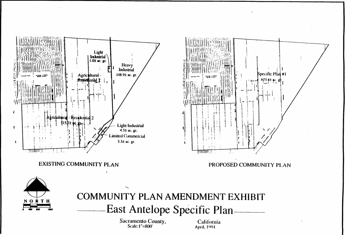
APPENDIX C: PRELIMINARY TECHNICAL STUDIES
Section titled “APPENDIX C: PRELIMINARY TECHNICAL STUDIES”This document is not available as part of this document. To request this information, please email SacPlan@saccounty.gov.