Chapter 1: Introduction
South Sacramento Habitat Conservation Plan
Chapter 1: Introduction
Section titled “South Sacramento Habitat Conservation Plan Chapter 1: Introduction”1.1 Overview
Section titled “1.1 Overview”The South Sacramento Habitat Conservation Plan (SSHCP or Plan) ensures preservation of species, natural communities, and aquatic resources in the Plan Area; while providing an improved environmental permitting process for Covered Activity projects that impact listed species, listed species habitats, or aquatic resources. The SSHCP is intended to preserve 28 species of plants and wildlife, including 11 that are listed as threatened or endangered under the federal Endangered Species Act (ESA), the California Endangered Species Act (CESA), or both. In addition, because so many of the Covered Species live part or all of their lives in water bodies, the SSHCP also provides additional avoidance and minimization of Covered Activity impacts to wetlands, streams, and other aquatic resources that are also subject to regulation under the federal Clean Water Act (CWA), the California Fish and Game Code, and California’s Porter-Cologne Water Quality Control Act.
The SSHCP was prepared by five local agencies, including the County of Sacramento (County), City of Galt, City of Rancho Cordova, Sacramento County Water Agency (SCWA), and the Southeast Connector Joint Powers Authority (Connector JPA). These five local agencies, plus the future SSHCP Implementing Entity (to be named the South Sacramento Conservation Agency), are collectively applying for Incidental Take Permits (ITP) and are referred to as the ‘Plan Permittees’ in this document.
The SSHCP Preserve System will conserve habitat that will be managed and monitored to demonstrate achievement of the Biological Goals and Measurable Objectives for Covered Species (see Chapter 7 for a complete discussion of the Plan’s Conservation Strategy). In exchange for habitat conservation and other commitments, the United States Fish and Wildlife Service (USFWS) and California Department of Fish and Wildlife (CDFW) (the Wildlife Agencies) will each issue an ITP that grants take for Covered Species resulting from the implementation of Covered Activities, including urban development and infrastructure construction and maintenance activities (see Chapter 5 for a definition of the SSHCP Covered Activities). The entities that receive take coverage under the ITPs are exempt from take prohibitions of Section 9 of the federal ESA for ‘take’ of Covered Species incidental to otherwise legal activities.
An important component of the SSHCP Conservation Strategy is an Aquatic Resources Program (ARP). As discussed in Chapter 7, the ARP (Appendix I of the SSHCP Environmental Impact Statement/Environmental Impact Report [EIS/EIR]) describes how the SSHCP strategy for the conservation of aquatic habitat in this Plan Area will avoid and minimize Covered Activity impacts on the Plan Area’s aquatic resources, and provide adequate compensatory mitigation for unavoidable Covered Activity impacts. In exchange for conservation of wetlands streams, riparian, and other Plan Area aquatic resources, the United States Army Corps of Engineers (USACE) plans to develop a multi-level permitting strategy under Section 404 of the CWA (CWA 404) for future Covered Activities that are consistent with all SSHCP requirements. This permit strategy is contained in Appendix C of the SSHCP EIS/EIR.
The Plan Permittees have requested that the Regional Water Quality Control Board (RWQCB) use the ARP document to develop a parallel program to issue Water Quality Certifications under Section 401 of the CWA (CWA 401), and a program to issue a Report of Waste Discharge under the California Porter-Cologne Water Quality Control Act. The Plan Permittees will also request that CDFW use the ARP document to develop a Master Streambed Alteration Agreement under Section 1600 of the California Fish and Game Code for Plan Permittee Covered Activities and to streamline permitting for all Covered Activities described with the SSHCP.
Shortly after the Natural Community Conservation Plan (NCCP) Act of 2003 was authorized by the state legislature, CDFW requested that the County convert the SSHCP from a standalone Habitat Conservation Plan (HCP) to a joint HCP/NCCP. Because the NCCP Act requires the protection of natural communities beyond what is required to mitigate species impacts, there were concerns that the preparation of a joint HCP/NCCP would not be feasible due to the Plan Area’s already limited inventory of land available for mitigation. However, recognizing the benefits that the NCCP Act provides for protection of natural communities, the Plan Permittees elected to include additional voluntary conservation (Appendix J) as a supplement to the SSHCP Conservation Strategy that, where feasible, would encourage preservation of additional acreage of natural communities and species habitat beyond what is required to mitigate effects of the Covered Activities to the maximum extent practicable. In so doing, the SSHCP includes some of the beneficial properties of an NCCP. However, take under CESA will be issued under California Fish and Game Code Section 2081.
Three of the Plan Permittees are also local jurisdictions with authority to permit or approve projects and activities within their jurisdictional boundary. Under the Plan, the three local Land Use Authority Permittees (Sacramento County, the City of Galt, and the City of Rancho Cordova) have the ability to extend incidental take coverage provided by the SSHCP ITPs to Covered Activities implemented by Third-Party Project Proponents that are under the jurisdiction of that Land Use Authority Permittee. This will allow Third-Party Project Proponents to avoid the extensive negotiation and processing currently required to obtain individual project permits under CESA from CDFW and project ESA compliance from USFWS. As discussed in Chapter 9, Third-Party Project Proponents are private project applicants proposing to implement an SSHCP Covered Activity and are seeking ministerial 1 or discretionary 2 project permits from a Land Use Authority Permittee.
In addition, Covered Activities implemented by Third-Party Project Proponents can avoid the extensive negotiation and processing currently required to obtain CWA 404 permits from the USACE and U.S. Environmental Protection Agency (USEPA), as well as extensive negotiation and processing currently required to obtain CWA 401 approvals from the RWQCB and to issue Reports of Waste Discharge under the California Porter-Cologne Act.
The future South Sacramento Conservation Agency (the SSHCP Implementing Entity) also has the ability to extend incidental take coverage provided by the ITPs to third-party Participating Special Entities. As discussed in Chapter 9, Participating Special Entities are third-party entities that may wish to implement a Covered Activity allowed by the SSHCP permits, but the entity is not under the jurisdiction of a Land Use Authority Permittee. Participating Special Entities might include school districts, reclamation districts, irrigation or water districts, utilities, or other organizations that are not subject to the regulatory authority of a local jurisdiction.
1.1.1 SSHCP Mission Statement
Section titled “1.1.1 SSHCP Mission Statement”The Plan Permittees and key stakeholders, participating in a goal-setting process, developed a set of broad program goals that collectively serve as the mission statement for this Plan. The goals developed are to:
- Ensure long-term viability of Covered Species in the Plan Area by preserving an adequate quality and quantity of habitat in an integrated regional manner and further contribute to species recovery.
- Protect, maintain, and restore the functions and services of waters of the United States and maintain the integrity of watersheds throughout the Plan Area.
- Accommodate development in sites consistent with Land Use Authority Permittee plans (County and the Cities of Galt and Rancho Cordova) in exchange for payment of a development fee and other mitigation.
- Promote the long-term viability of agricultural uses consistent with the Plan, and ensure that agricultural lands and operations are not unduly impacted by the SSHCP’s implementation.
- Promote awareness and appreciation of the Plan Area’s natural history and provide environmental education opportunities for local residents.
- Create a standardized and predictable permitting process without unforeseen mitigation obligations.
- Provide a comprehensive framework for land use by linking plant and animal conservation with local land use programs, consistent with the goals and policies of each local Land Use Authority Permittee.
- Provide for stakeholder involvement and public input during the preparation of Plan documents.
1.1.2 Purpose and Benefits of the SSHCP
Section titled “1.1.2 Purpose and Benefits of the SSHCP”The purpose of the SSHCP is to ensure the long-term survival of the species covered in this Plan by preserving and establishing/re-establishing the habitats, natural communities, and ecosystem functions that they rely on, while allowing appropriate and compatible urban growth and development. The Plan also requires measures that will avoid, minimize, and mitigate impacts to the species, thereby addressing the permitting requirements relevant to these species for activities conducted by or under the jurisdiction of the Plan Permittees. These activities (i.e., the SSHCP Covered Activities, see Chapter 5) include urban development and infrastructure projects, such as roadway improvements and sewer and water line construction. The Plan also describes activities associated with operating and maintaining a new SSHCP Preserve System, which will be created to mitigate anticipated impacts resulting from urban development and infrastructure activities.
This Plan is an HCP intended to fulfill the requirements of CESA and the federal ESA. The Plan also addresses Covered Activity permitting requirements for the federal CWA, California’s Porter-Cologne Water Quality Control Act, and Fish and Game Code streambed alternation agreement requirements. In addition to providing impact mitigation, this Plan is intended to aid in the recovery and possible delisting of listed species. The Plan’s Conservation Strategy (Chapter 7) may help preclude the need to list additional species in the future through the preservation of habitat that benefits species.
The SSHCP will offer numerous benefits, including the following:
- Provides County, City of Galt, and City of Rancho Cordova residents with an interconnected Preserve System that maintains natural communities and species habitat at a regional scale including aquatic resources and other biological resources and maintains open space and intact watersheds for future generations.
- Conservation of native species that live in or move through the Plan Area.
- Offers protection for a broad range of native species and species habitats in a regionally coordinated manner to provide greater opportunity for long-term viability of native species populations; conserves and enhances ecosystem functions; and establishes a substantial system of interconnected Preserves that are located in areas with the highestquality species habitat. The SSHCP will provide landscape-level Preserves and will connect the existing patchwork of mostly small, isolated, and noncontiguous Preserves throughout the Plan Area that resulted from past project permitting.
- Provides for the protection and enhancement of stream, riparian, and aquatic resources, which are expected to help maintain water quality throughout the region.
- Re-establishes species habitat where habitat once occurred in the Plan Area.
- Affords an opportunity for landowners to voluntarily sell conservation easements that will preserve existing agricultural practices and uses for future generations.
- Allows for an expedited and predictable process for project permitting under the federal ESA, CESA, and 404 of the CWA. Because the requirements to obtain incidental take coverage are standardized in the SSHCP, the Plan makes the requirements and their associated costs more predictable.
- Allows for an expedited and predictable process for project permitting under Sections 401 of the CWA and Porter-Cologne Water Quality Control Act as well as Section 1600 of the California Fish and Game Code.
- Provides a means to preserve habitat resources that occur within designated Critical Habitat and Core Recovery Areas.
- Provides future incidental take authorization of currently non-listed federal species that may become listed during the Permit Term.
- Allows a reasonable amount of development to occur that supports economic growth.
Incidental take authorization will be granted to the Plan Permittees by the USFWS and CDFW ITPs. The Plan Permittees are asking the USFWS and CDFW to issue permits that allow incidental take of Covered Species when the take is consistent with the provisions of this Plan, the Implementing Agreement 3 (see Appendix C), and the terms and conditions of the ITPs. The Plan includes a Conservation Strategy to compensate for impacts to the Covered Species. The Conservation Strategy also provides for the conservation and management of Covered Species and their habitats.
It is expected that each of the Plan Permittees (including the Plan’s future Implementing Entity) will be a permittee on the federal ESA Section 10(a)(1)(B) ITP and a permittee on the California Fish and Game Section 2081 ITP that will authorize species take that results from implementation of SSHCP Covered Activities (Chapter 5). The Plan Permittees will also receive a Master Streambed Alteration Agreement. Finally, the Plan will address federal CWA and California Porter-Cologne Water Quality Control Act permitting requirements through an ARP and subsequent permitting strategy prepared by the USACE and RWQCB. While the Plan Permittees will not hold permits to address CWA and California Porter-Cologne Water Quality Control Act permitting requirements (with some exceptions as discussed in the ARP) the CWA and California Porter-Cologne Water Quality Control Act permitting strategy prepared by the USACE and RWQCB specifically for the SSHCP will significantly streamline the permitting process.
In addition to their own Covered Activities, the three local Land Use Authority Permittees (County, City of Galt, and City of Rancho Cordova) can also extend incidental take coverage provided by the ITPs to third-party projects that are Covered Activities and under their jurisdiction. 4 The USFWS will also provide ‘no surprises’ assurances to the Plan Permittees, where the USFWS will not require the commitment of additional land, water, or financial compensation (or additional restrictions on the use of land, water, or other natural resources) for impacts to Covered Species beyond the level agreed upon and described in the Plan-as long as the Plan Permittees are adequately implementing the Plan (see Chapter 9). Compliance with the Plan will also satisfy CEQA mitigation requirements for impacts to biological resources.
It should be noted that the SSHCP is not a land use document. All land use decisions will continue to be made by the respective jurisdictions consistent with their existing authority, regulations, and policies. Neither implementation of the SSHCP nor issuance of the ITPs constitutes approval of the activities or projects that could obtain federal ESA and CESA coverage under the SSHCP permits. Such land use approvals can only be obtained from the relevant jurisdiction (the relevant Land Use Authority Permittee) through the existing land use approval processes.
1.1.3 Background
Section titled “1.1.3 Background”The SSHCP was first initiated to implement Sacramento County General Plan Policies that promote the protection of natural resources while providing an alternative means to comply with ESA permitting processes. In 2011, the County updated its General Plan and incorporated several policies designed to mirror objectives from the SSHCP. The SSHCP provides a means to implement several of those County policies (see Chapter 4, Land Use), including, but not limited to, Policy CO-58, which ensures no-net-loss of wetlands, riparian woodlands, and oak woodlands, and Policy CO-65, which requires the creation of a network of Preserves linked by Wildlife Movement Corridors.
The SSHCP also provides a means to comply with two completed Biological Opinions (BOs) issued by the USFWS in response to an ESA consultation regarding water contracts for Sacramento County. In March of 1999, the Zone 40 BO (USFWS 1999) was issued by USFWS regarding water contracts for portions of Sacramento County under Public Law (P.L. 101-514). The Zone 40 BO requires U.S. Bureau of Reclamation, San Juan Water District (District), the County, and SCWA to implement various habitat conservation measures. One such measure requires the Bureau of Reclamation, District, County, and SCWA to identify goals for habitat conservation in their respective jurisdictions to conserve vernal pool species and associated upland habitats; a goal that could be achieved through the preparation of a regional HCP. The Zone 40 BO further specifies that the County shall diligently pursue completion of an HCP to obtain an ITP for indirect effects of the water contracts on federally listed species. In September of 2004, the County, SCWA, SRCSD, and USFWS signed a Memorandum of Agreement that set forth several agreements and courses of action that would allow projects in Sacramento County to proceed through construction permitting, including federal ESA Section 7 consultations, in a reasoned and legally permissible manner (County of Sacramento et al. 2004). The Memorandum of Agreement states that future development projects in Zone 40 will incur direct and indirect effects under the federal ESA, and further outlines the means by which those species effects could be addressed. The four parties agreed that the County will proceed with completion of the SSHCP as the most efficient means to address those future effects.
In December of 2004, the Freeport Regional Water Project BO was issued (USFWS 2004) to cover the Bureau of Reclamation’s (1) authorization for East Bay Municipal Utility District (EBMUD) and SCWA to use the new water diversion facility on the Sacramento River at Freeport; (2) authorization for the Freeport Regional Water Agency and EBMUD to use the Folsom South Canal to convey EBMUD’s Central Valley Project water; (3) fulfillment of EBMUD contract to complete federal ESA compliance before delivering any water to EBMUD; and (4) approval of an assignment of 30,000 acre-feet annually of water from Sacramento Municipal Utilities District to SCWA. The Freeport Regional Water Project Freeport Regional Water Project BO also reinitiated consultation on the Bureau of Reclamation’s long-term Central Valley Project water contract with SCWA. The Freeport Regional Water Project BO heavily references both the Zone 40 BO and the County of Sacramento agencies Memorandum of Agreement (County of Sacramento et al. 2004), including County completion of a regional HCP. Future development projects that would receive water service provided through the new Freeport Regional Water Project facilities must comply with the federal ESA before receiving entitlements from the County, and before water can be delivered. Projects must first demonstrate compliance with the federal ESA or the County will withhold approval of final maps, improvement plans, or building permits, and the SCWA will not issue a will-serve letter. The County and SCWA have determined that the most efficient means to comply with the 2004 Memorandum of Agreement is through preparing and implementing the SSHCP.
1.2 Scope of the Habitat Plan
Section titled “1.2 Scope of the Habitat Plan”This section describes the Plan’s geographic scope, Covered Activities, Permit Term, and Covered Species.
1.2.1 Geographic Scope of the Plan Area
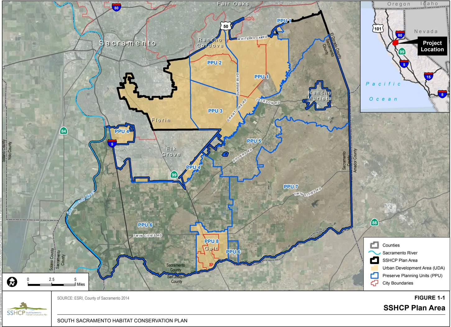
Section titled “1.2.1 Geographic Scope of the Plan Area”The Plan Area includes 317,655 acres within south Sacramento County, including the City of Galt and most of the City of Rancho Cordova (see Figure 1-1, SSHCP Plan Area). The Plan Area is defined as the area in which all Conservation Actions will be implemented and where all incidental take will occur. The boundary of the Plan Area was defined using political and ecological factors. The geographical boundaries are U.S. Highway 50 to the north, the Sacramento River levee and County Road J11 (Walnut Grove-Thornton Road) to the west, the Sacramento County line with El Dorado and Amador Counties to the east, and the San Joaquin County line to the south.
The Plan Area excludes the northern portion of Sacramento County, the northern portions of the City of Rancho Cordova, the City of Sacramento, the City of Elk Grove, the City of Folsom, the sovereign lands of the Miwok Tribe, and the Sacramento County community of Rancho Murieta (see Figure 1-1). These areas were excluded from the Plan Area because they were either significantly built out, would not use the SSHCP, or were not likely to benefit from the SSHCP due to the absence of listed species or their habitats. The sovereign lands of the Miwok Tribe are not included as the tribe is not a proposed Plan Permittee.
SSHCP Urban Development Area
Section titled “SSHCP Urban Development Area”The Plan Area is functionally divided into two components: inside and outside of an Urban Development Area (UDA). Inside the UDA is predominantly where development Covered Activities under this Plan will occur and, therefore, where most incidental take will occur. There will also be some habitat preservation within the UDA. The ‘inside the UDA’ component totals 67,618 acres within the Plan Area. Geographically, the UDA is the portion of the Sacramento County Urban Services Boundary (USB), the incorporated Cities of Rancho Cordova and Galt, and Galt’s Sphere of Influence that are also within the Plan Area (see Figure 1-1) because these are the Plan Partners for the SSHCP. The Plan Area component located outside of the UDA totals 250,038 acres. No urban development is covered under the SSHCP outside of the UDA. A limited amount of incidental take is requested for specific infrastructure projects and for species conservation activities proposed outside of the UDA. It should be noted that the SSHCP is not a land use plan and does not preclude non-SSHCP activities from occurring outside of the UDA.
SSHCP Preserve Planning Units
Section titled “SSHCP Preserve Planning Units”To assist with development of the SSHCP Conservation Strategy, the Plan Area was further divided into eight Preserve Planning Units (PPUs) that encompass areas where important Covered Species resources are present, and where habitat preservation will be planned (see Figure 1-1). These eight SSHCP PPUs are geographic subdivisions of the Plan Area designed to ensure that adequate Biological Goals and Measurable Objectives (see Chapter 7) were developed for all biological resources located within the Plan Area.
PPUs were delineated to capture specific habitat or agricultural land cover types or areas identified as being important for a specific suite of species. For instance, PPU 7, which is located in the southeastern portion of the Plan Area, was delineated to encompass the vast majority of vernal pool grasslands remaining in the County. PPU 7 also contains the designated Cosumnes/Rancho-Seco Core Recovery Area (C/RS) (USFWS 2005). PPU 2 contains the designated Mather Core Recovery Area (USFWS 2005). PPU 6, located in the southwestern portion of the Plan Area, was delineated to encompass a vast majority of agricultural cover types that provide foraging habitat for many covered raptor species. While geopolitical or physical landmarks were used to delineate some PPU boundaries, this was done for ease of mapping and to make locating PPU boundaries in the field easier.
PPUs 1 through 4 and 8 are within the UDA. However, a small portion of PPU 1 (2,156 acres near the County landfill) is located outside of the UDA. PPUs 5, 6, and 7 are outside the UDA.
A portion of the Plan Area in the middle of the UDA (14,085 acres) and a small portion of the area outside of the UDA in the extreme northeastern portion of the Plan Area (9,245 acres) are not within a PPU (see Figure 1-1). A complete description of each PPU, including species occurrences and land cover types within each PPU, can be found in Chapter 3, Biological Resources Setting.
1.2.2 Covered Activities
Section titled “1.2.2 Covered Activities”As discussed in Chapter 5, SSHCP Covered Activities are projects or activities that were evaluated during development of the Plan and are allowable under the Plan’s ITPs. The Covered Activities provide for the expansion of the urbanizing areas within the County’s existing USB, within the current city limits of Galt and Rancho Cordova, and within the extra territorial Sphere of Influence for the City of Galt (i.e., within the SSHCP’s UDA, as defined in Section 1.2.1). Covered Activities within the UDA include activities and projects related to urban development and associated infrastructure that are consistent with the General Plans of the three Land Use Authority Permittees, as well as specific activities and projects related to transportation, water, and wastewater development. In-stream maintenance occurring within the UDA (e.g., vegetation and sediment removal) will also be a Covered Activity under the Plan. Covered Activities outside of the UDA are limited to specific infrastructure projects related to roadway improvements and recycled water delivery. The SSHCP Covered Activities also include actions within the proposed SSHCP Preserve System related to the management and monitoring of preserved habitats, the enhancement of habitat, and the re-establishment of habitat within the SSHCP Preserve System. Chapter 5, Covered Activities, describes the proposed Covered Activities by type, with lists of anticipated covered activities and projects, if currently known.
1.2.3 Permit Term
Section titled “1.2.3 Permit Term”The Permit Term defines the length of time in which ITPs issued by the Wildlife Agencies (USFWS and CDFW) can be used by the Plan Permittees for incidental take resulting from Covered Activities, and the timeframe in which all Conservation Actions outlined in the SSHCP Conservation Strategy must be completed. The Plan Permittees are seeking ITPs that are valid for a term of 50 years. The Plan Permittees can request a permit extension upon or prior to expiration of the original permit by applying to the state and federal Wildlife Agencies. The ITP term is based on the projected timeframe for buildout to occur within the Plan’s UDA, as well as the timeframe to complete proposed capital improvement projects. While it is difficult to predict trends in urban development beyond a 15- to 20-year timeframe, a 50-year permit is believed to be reasonable and necessary to provide sufficient time to implement Covered Activities and to complete the establishment of the Preserve System. For purposes of the SSHCP, the term ‘full buildout’ is defined as the total development of the UDA, with the exception of planned UDA Preserves as described in Chapter 7.
A summary of major local planning documents and their respective time horizons is provided in Table 1-1. Urban development consistent with County and City General Plans accounts for a vast majority of the take that will occur from Covered Activities addressed under the Plan (City of Galt 2009; City of Rancho Cordova 2006; County of Sacramento 2011). The County has a designated USB that acts as a de-facto urban growth line. The County will not provide water or sewer services to projects located outside of the USB. The County predicts that the USB contains enough land to support at least 50 years of urban development (County of Sacramento 2011).
Table 1-1 Local Planning Documents and Time Horizons Relevant to the Permit Term
| Document | Date Produced | Projection/Time Horizon | Plan Duration |
|---|---|---|---|
| City of Galt General Plan | 2009 | 2030 | 16 years |
| City of Rancho Cordova General Plan | 2006 | 2030/2050 | 16-36 years |
| County of Sacramento General Plan | 1993; updated 2011 | 2030 | 16 years |
| County of Sacramento General Plan USB | 1993 | At least until 2060 | 46 years |
Sources: City of Galt 2009; City of Rancho Cordova 2006; County of Sacramento 2011.
In addition, timelines for funding and completing capital improvement projects often extend for decades. A Permit Term that allows for the completion of Covered Activities that are associated with construction of planned capital improvement projects, such as the Southeast Connector and recycled water projects, will likely take more than four decades to complete. Other planned Covered Activity projects (see Chapter 5) may take several decades to receive the funding needed to implement them, such as safety improvements proposed for many roadways within the Plan Area.
Some Covered Activities are not expected to be implemented until later in the 50-year Permit Term. Such activities include the many bridge replacement projects and several road-widening projects, as described in Chapter 5. Therefore, a longer Permit Term is necessary to anticipate and adequately mitigate the impacts of these projects on the Covered Species.
Recurring maintenance activities are expected to continue in perpetuity; consequently, take authorization for these activities is needed for as long a period as is feasible. As described in Chapter 5, these recurring Covered Activities might affect the Covered Species throughout the proposed 50-year Permit Term. For example, road maintenance performed by the County occurs annually. Maintenance on rural roads might affect habitat for many Covered Species, including California tiger salamander (Ambystoma californiense), western spadefoot (Spea hammondii), western burrowing owl ( Athene cunicularia hypogea ), and many covered plant species. Similarly, recurring maintenance on flood control and storm drainage facilities by SCWA are covered in this Plan (see Chapter 5), and might affect aquatic Covered Species for the duration of the Permit Term. For example, maintenance of waterways has the potential to affect giant gartersnake (Thamnophis gigas) and western pond turtle ( Actinemys marmorata).
A 50-year Permit Term is also necessary to establish the operational SSHCP Preserve System described in Chapter 7, and to develop and test the Preserve System Management and Monitoring programs described in Chapter 8. Because the Plan only acquires conservation easements or land in fee title from willing sellers (see Chapter 9), it is anticipated that it could take several decades to acquire enough land to complete the SSHCP Preserve System. Many landowners, who may be interested in selling an easement or land, may not be willing to do so now for estate planning and/or tax purposes. A 50-year Permit Term provides adequate time for willing landowners to become available and for the Plan’s Implementing Entity to negotiate fee title or conservation easement acquisitions.
Monitoring and assuring the success of habitat re-establishment/establishment actions (described in Chapter 8) is expected to take 5-10 years for each re-establishment/establishment project. Most habitat re-establishment/establishment actions cannot be initiated until land is acquired for the Preserve System. A Permit Term of 50 years is necessary to allow enough time to complete land acquisition with at least 5 years remaining on the permit in which to successfully initiate or complete (and possibly remediate if necessary) all re-establishment/establishment actions. The Plan Permittees have committed to installing all habitat re-establishment/establishment projects by year 40. Therefore, a 50-year Permit Term is necessary to complete these actions and to leave sufficient time for monitoring the effectiveness of these actions before the Permit Term ends.
A 50-year Permit Term also allows sufficient time to generate the necessary funding for Plan implementation. As described in Chapter 12, Economic Analysis and Funding Program, the Plan will primarily be funded by development fees collected when Covered Activities and projects are approved by the Plan Permittees. Many of the Plan’s Covered Activities will not occur for decades, as explained above. A 50-year Permit Term provides the time necessary to ensure adequate funding for Preserve acquisition and to establish the non-wasting endowment that is required to fund monitoring and management in perpetuity.
Based on the implementation horizon for Covered Activities, the recurring operation and maintenance activities, the need to acquire lands and develop a successful Preserve System, and the need for adequate funding, the Plan Permittees have determined that a 50-year Permit Term would best address regulatory and biological considerations. In summary, the 50-year Permit Term provides sufficient time to accomplish the following critical elements of the Plan:
- Fully implement the current general plans of the cities and the County;
- Fully implement the Plan Permittees’ capital projects that are covered by the Plan;
- Implement the Plan Permittees’ ongoing maintenance activities as long as feasible;
- Allow sufficient time to assemble the SSHCP Preserve System from willing sellers and partnerships with local agencies and private landowners;
- Secure all necessary funding for Plan implementation during the Permit Term and secure funds during the Permit Term to fund the Plan’s Conservation Strategy in perpetuity;
- Develop an effective Preserve System maintenance, monitoring, and adaptive management program (Chapter 8) that will be implemented in perpetuity (as discussed in Chapter 8, an adaptive management program will be included in the SSHCP); and
- Provide sufficient incentive for the Plan Permittees to commit the substantial resources necessary to complete the SSHCP (i.e., the Permit Term covers enough projects and activities to make the large up-front investment in the Conservation Strategy cost-effective).
1.2.4 Covered Species
Section titled “1.2.4 Covered Species”Covered Species are species that will be listed on the CESA and federal ESA ITPs issued by the two Wildlife Agencies (USFWS and CDFW). The Plan addresses 28 Covered Species (20 wildlife species and 8 plants), of which, 11 are currently listed as threatened or endangered under CESA or the federal ESA (see Table 1-2 for a complete list of species covered under this Plan). The 28 species were identified through a species evaluation and selection process, as discussed below.
Table 1-2 SSHCP Covered Species and Their Current Listing Status
| Scientific Name Common Name | Species | Federal Status | State Status | CRPR Status |
|---|---|---|---|---|
| Lepidurus packardi Vernal pool tadpole shrimp | Invertebrates | E* | - | - |
| Branchinecta lynchi Vernal pool fairy shrimp | Invertebrates | T* | - | - |
| Branchinecta mesovallensis Mid-valley fairy shrimp | Invertebrates | - | - | - |
| Desmocerus californicus dimorphus Valley elderberry longhorn beetle | Invertebrates | T | - | - |
| Hydrochara rickseckeri Ricksecker’s water scavenger beetle | Invertebrates | - | - | - |
| Ambystoma californiense California tiger salamander, (Central Valley population) | Amphibians | T* | T | - |
| Spea hammondii Western spadefoot | Amphibians | - | CSC | - |
| Actinemys marmorata Western pond turtle | Reptiles | - | CSC | - |
| Thamnophis gigas Giant gartersnake | Reptiles | T | T | - |
| Accipiter cooperii Cooper’s hawk | Birds | - | WL | - |
| Agelaius tricolor Tricolored blackbird | Birds | BCC | T (Emergency Listed) | - |
| Athene cunicularia hypugaea Western burrowing owl | Birds | BCC | CSC | - |
| Buteo regalis Ferruginous hawk | Birds | BCC | - | - |
| Buteo swainsoni Swainson’s hawk | Birds | BCC | T | - |
| Circus cyaneus Northern harrier | Birds | - | CSC | - |
| Elanus leucurus White-tailed kite | Birds | - | CFP | - |
| Grus canadensis tabida Greater sandhill crane | Birds | - | T; CFP | - |
| Lanius ludovicianus Loggerhead shrike | Birds | BCC | CSC | - |
| Lasiurus blossevillii Western red bat | Mammals | - | CSC | - |
| Taxidea taxus American badger | Mammals | - | CSC | - |
| Downingia pusilla Dwarf downingia | Plants | - | - | 2.2 |
| Gratiola heterosepala Boggs Lake hedge-hyssop | Plants | - | E | 1B.2 |
| Juncus leiospermus var . ahartii Ahart’s dwarf rush | Plants | - | - | 1B.2 |
| Legenere limosa Legenere | Plants | - | - | 1B.1 |
| Navarretia myersii Pincushion navarretia | Plants | - | - | 1B.1 |
| Orcuttia tenuis Slender Orcutt grass | Plants | T* | E | 1B.1 |
| Orcuttia viscida Sacramento Orcutt grass | Plants | E* | E | 1B.1 |
| Sagittaria sanfordii Sanford’s arrowhead | Plants | - | - | 1B.2 |
Status Definitions
Federal:
E = Listed as endangered under the federal ESA
T = Listed as threatened under the federal ESA
[*] = Species has designated Critical Habitat located within the Plan Area.
[-] No federal ESA listing
BCC = Bird of Conservation Concern, USFWS 2008.
State:
E = Listed as endangered under CESA
T = Listed as threatened under CESA
CFP = Fully protected under the California Fish and Game Code
CSC = Species of special concern in California
WL = Watch List
[-] = No state status
California Native Plant Society California Rare Plant Rank (CRPR):
1B = Rare, threatened, or endangered in California and elsewhere
2 = Rare, threatened, or endangered in California but more common elsewhere
CRPR Threat Ranks:
0.1 = Seriously threatened in California (high degree/immediacy of threat)
0.2 = Fairly threatened in California (moderate degree/immediacy of threat)
0.3 = Not very threatened in California (low degree/immediacy of threats or no current threats known)
Species Evaluation
Section titled “Species Evaluation”A Technical Advisory Committee (TAC) composed of local species experts compiled an initial list of 90 species to be considered for coverage under the Plan. The TAC identified all specialstatus species that also had the potential to occur within the Plan Area using data from a variety of sources, including CDFW’s California Natural Diversity Database (CNDDB), USFWS files and databases, California Native Plant Society (CNPS) plant inventories, Sacramento County Audubon files, and solicited opinions from local experts, university researchers, and resource agency staff.
The initial list of 90 special-status species was compiled for the Plan Area. ‘Special status’ is defined using the following criteria:
- Listed as Threatened or Endangered by the USFWS (50 CFR 17.11 [listed animals] 50 CFR 17.12 [listed plants], and various notices in the Federal Register [proposed and candidate species]);
- Listed or candidate for listing as Rare, Threatened, or Endangered under CESA (14 California Code of Regulations [CCR] 670.5);
- Designated as a ‘bird species of concern’ by the USFWS;
- Designated as a species of special concern by the CDFW;
- Subject to protection under California Fish and Game Code Section 3503.5 (breeding raptors);
- Designated as Fully Protected under California Fish and Game Code Section 3511(birds), Section 4700 (mammals), Section 5515 (fish), and Section 5050 (reptiles and amphibians);
- Determined to meet the definition of rare or endangered under CEQA (CEQA Guidelines, Section 15380);
- Designated as a California Rare Plant Rank (CRPR) 1B (rare, threatened, or endangered throughout its range) or CRPR 2 (rare, threatened, or endangered in California but more common elsewhere) in the CNPS inventory; or
- No special status but are believed by local experts to be rare enough to merit listing within the timeframe of this Plan.
The initial list of 90 species was eventually reduced to 28 proposed Covered Species (Table 1-2). Species were eliminated from consideration as Covered Species if the TAC determined the species would not be adversely affected by Covered Activities, if the TAC determined that there was not enough information available to adequately evaluate impacts to the species or to identify adequate conservation measures to offset those impacts.
The Plan includes Conservation Actions to protect all 28 Covered Species whether or not they are currently listed under the ESA or the CESA. As SSHCP Covered Species, any currently non-listed species that is covered under the Plan will not require additional conservation within the Plan Area should the species become listed under the federal ESA during the Plan’s Permit Term. As discussed in Chapter 11, the USFWS ITP will include ‘no surprises’ assurances to the Plan Permittees for all Covered Species, regardless of their ESA listing status (Chapter 11). However, Covered Species that are currently not listed but become listed under CESA will require an amendment to the CDFW ITP to be covered by CESA.
Owing to the rarity of slender Orcutt grass ( Orcuttia tenuis) and Sacramento Orcutt grass ( Orcuttia viscida) , the Plan Permittees are not requesting incidental take coverage for those Covered Species (see Chapter 5); rather the SSHCP Conservation Strategy (Chapter 7) will fully avoid and protect all slender Orcutt grass and Sacramento Orcutt grass occurrences within the Plan Area.
Two of the proposed SSHCP Covered Species (white-tailed kite [ Elanus leucurus ] and greater sandhill crane [ Grus canadensis tabida ]) are designated as Fully Protected Species under the California Fish and Game Code Section 3511 and thus direct injury or mortality of those Covered Species will not be included in the state or federal ITPs. Therefore, this Plan also includes Avoidance and Minimization Measures (AMMs) to avoid direct death or injury of white-tailed kite and greater sandhill crane during the implementation of any SSHCP Covered Activity.
1.2.5 Areas Outside the UDA
Section titled “1.2.5 Areas Outside the UDA”As discussed, the SSHCP provides a streamlined permitting process for Covered Activities identified in the Plan. This does not preclude activities from occurring outside the UDA, provided they obtain the legally required local, state, and federal permits and approvals otherwise and customarily required, including mitigation for impacts caused by those activities. The required mitigation should be crafted in consultation with the Implementing Entity, but the final decision will be made by the applicable lead agency pursuant to their thresholds and regulations.
1.3 Regulatory Setting
Section titled “1.3 Regulatory Setting”The Plan is designed to comply with the federal ESA and the CESA, as well as the federal CWA, the California Porter-Cologne Water Quality Control Act, and the California Fish and Game Code Sections 1600-1616. The Plan is also consistent with other federal and state wildlife and natural resource-related laws and regulations, listed here and described in greater detail below:
- Migratory Bird Treaty Act
- Bald and Golden Eagle Protection Act
- California Fish and Game Code, Sections 3511, 4700, 5050, and 5515 (fully protected species)
- California Fish and Game Code, Section 3503 (bird nests)
- California Fish and Game Code, Section 3503.5 (birds of prey)
- National Environmental Policy Act of 1969 (NEPA)
- California Environmental Quality Act of 1970 (CEQA)
- National Historic Preservation Act (NHPA).
1.3.1 Federal and State Endangered Species Laws
Section titled “1.3.1 Federal and State Endangered Species Laws”Federal Endangered Species Act
Section titled “Federal Endangered Species Act”USFWS and the National Marine Fisheries Service (NMFS) administer the federal ESA. The federal ESA requires USFWS and NMFS to maintain lists of threatened and endangered species and affords substantial protection to listed species. NMFS’ jurisdiction under the ESA is limited to the protection of marine mammals, marine fishes, and anadromous fishes; all other listed species are subject to USFWS jurisdiction. USFWS and NMFS can list species as either endangered or threatened. An endangered species is at risk of extinction throughout all or a significant portion of its range (16 U.S.C. 1532). A threatened species is likely to become endangered within the foreseeable future (16 U.S.C. 1533). Seven SSHCP Covered Species are listed under the federal ESA: Sacramento Orcutt grass, slender Orcutt grass, vernal pool tadpole shrimp (Lepidurus packardi), vernal pool fairy shrimp (Branchinecta lynchi), valley elderberry longhorn beetle ( Desmocerus californicus dimorphus ), California tiger salamander, and giant gartersnake (Table 1-2).
Section 9
Section titled “Section 9”Section 9 of the federal ESA prohibits the ‘take’ of any fish or wildlife species listed under the ESA as endangered or threatened. 5 ‘Take,’ as defined by the federal ESA, means
‘to harass, harm, pursue, hunt, shoot, wound, kill, trap, capture, or collect, or to attempt to engage in any such conduct’ (16 U.S.C. 1533).
‘Harm’ in the definition of ‘Take’ means
‘an act that kills or injures the species, including significant habitat modification or degradation where it actually kills or injures wildlife by significantly impairing essential behavioral patterns, including breeding, feeding, or sheltering’ (50 CFR 17.3).
‘Harass’ in the definition of ‘Take’ means
‘an intentional or negligent act or omission which creates the likelihood of injury to wildlife by annoying it to such an extent as to significantly disrupt normal behavior patterns which include, but are not limited to breeding, feeding, or sheltering’ (50 CFR 17.3).
Section 9 also prohibits the ‘removal or reduction to possession’ of any listed plant species ‘under federal jurisdiction’ (e.g., on federal land, where federal funding is provided, or where federal authorization is required). The take prohibition for listed plants is more limited than for listed fish and wildlife. Under Section 9(a)(2)(B) of the ESA, listed plants are protected from ‘removal, reduction to possession, and malicious damage or destruction’ in areas that are under federal jurisdiction. Section 9(a)(2)(B) of the ESA also provides protection to plants from removal, cutting, digging up, damage, or destruction where the action takes place in knowing violation of any state law or regulation or in violation of a state criminal trespass law. Thus, the ESA does not prohibit the incidental take of federally listed plants on private or other nonfederal lands unless the action requires federal authorization or is in violation of state law or regulation.
Even though under the ESA there is limited prohibition for incidental take of plants on nonfederal lands, the SSHCP includes many plant Covered Species (see Table 1-2), and the Plan Permittees are requesting that the plant Covered Species be included on the ITPs when they are issued. Some plants are Covered Species to meet regulatory obligations under ESA Section 7the USFWS must review the effects of its own actions on federally listed plants, even when those listed plants are found on private lands. Also, all plant species protected by state law (e.g., CESA) are also subject to the ESA Section 9 take prohibition. Incidental take authorization is also requested for the eight plant Covered Species to provide the Plan Permittees with ESA Section 10 ‘no surprises’ assurances for the plant Covered Species.
The federal ESA includes mechanisms that provide exceptions to the Section 9 take prohibitions. These exemption mechanisms are addressed in Section 7 for federal actions and Section 10 for nonfederal actions.
Section 7
Section titled “Section 7”Section 7 of the federal ESA requires all federal agencies to ensure that any action they permit, authorize, fund, or carry out is not likely to jeopardize the continued existence of any listed species or result in the destruction or adverse modification of habitat critical to such species’ survival. To ensure that its actions do not result in jeopardy to listed species or in the adverse modification of Critical Habitat, 6 each federal agency must consult with USFWS or NMFS or both regarding federal agency actions that may affect listed species. Consultation begins when the federal agency submits a written request for initiation to USFWS or NMFS, along with the agency’s biological assessment of its proposed action, and when USFWS or NMFS accepts that biological assessment as complete. If USFWS or NMFS concludes that the action is not likely to adversely affect a listed species, the action may be conducted without further review under the federal ESA. Otherwise, USFWS or NMFS must prepare a written BO under ESA Section 7 describing how the agency’s action will affect the listed species and its Critical Habitat.
If a BO concludes that the proposed action would jeopardize the continued existence of a listed species or adversely modify its designated Critical Habitat, the opinion will suggest ‘reasonable and prudent alternatives’ that would avoid that result. If a BO concludes that the proposed action would take a listed species but would not jeopardize its continued existence, the BO will include an incidental take statement. Incidental take is take that is ‘incidental to, and not intended as part of, an otherwise lawful activity’ (50 CFR 402.02). The incidental take statement specifies an amount of species take that is allowed to occur as a result of the proposed action, and may require reasonable and prudent measures to minimize the impact of the take.
Projects with a federal lead agency or a federal nexus (e.g., requires a federal permit or federal funding, is carried out by a federal agency, or is a project on federal land) can obtain species take authorization through ESA Section 7 rather than ESA Section 10. The proposed issuance of an ITP by the USFWS for the SSHCP is a federal action, and therefore, requires the USFWS to consult under Section 7 of the ESA. To comply with Section 7 of the ESA, the USFWS Sacramento Field Office would conduct an internal Section 7 consultation with the USFWS Region 8 office concerning the region’s decision to issue ITPs to the Plan. The results of this internal consultation would be documented in a BO, which would be prepared prior to the ITP decision for the SSHCP.
Section 10
Section titled “Section 10”Until 1982, state, local, and private entities had no means to acquire incidental take authorization as could federal agencies under Section 7. Private landowners and local and state agencies risked violation of the federal ESA no matter how carefully their projects were implemented. This statutory dilemma led Congress to amend Section 10 of the ESA in 1982 to authorize the issuance of an ITP to nonfederal project proponents upon completion of an approved conservation plan. The term ‘conservation plan’ has evolved into ‘habitat conservation plan.’
In cases where federal land, funding, or authorization is not required for an action by a nonfederal entity, the take of listed fish and wildlife species can be permitted by USFWS and/or NMFS through the Section 10 process. Private landowners, corporations, state agencies, local agencies, and other nonfederal entities must obtain a Section 10(a)(1)(B) ITP for ‘take’ of federally listed fish and wildlife species ‘that is incidental to, but not the purpose of, otherwise lawful activities.’
All HCPs must specify the following mandatory elements:
- The impact that will likely result from the taking of Covered Species;
- The steps the Plan Permittees will take to monitor, minimize, and mitigate such impacts to the maximum extent practicable;
- The funding that will be available to implement such steps;
- The procedures to be used to deal with unforeseen circumstances; 7
- The alternative actions to such taking the Plan Permittees considered and the reasons why such alternatives are not proposed to be utilized; and
- Such other measures that the Director [of the Department of Interior or Commerce] may require as being necessary or appropriate for purposes of the plan (50 CFR 17.22[b]).
The SSHCP is intended to satisfy these requirements. To receive an ITP, Section 10(a)(2)(B) of the federal ESA and permit regulations 50 CFR 17.22(b)(2) and 17.32(b)(2) require that the following permit issuance criteria be met:
- The taking will be incidental to otherwise lawful activities;
- The Plan Permittees will minimize and mitigate the impacts of such taking to the maximum extent practicable;
- The Plan Permittees will ensure adequate funding for the HCP and for procedures to deal with changed and unforeseen circumstances;
- The taking will not appreciably reduce the likelihood of survival and recovery of the species in the wild (i.e., will not cause jeopardy under Section 7(a)(2) of the ESA);
- The Plan Permittees will ensure that other measures that the USFWS may require as being necessary or appropriate will be provided; and
- The USFWS has received such other assurances as may be required that the HCP will be implemented.
Prior to the issuance of an ITP, USFWS is required to undertake an internal Section 7 consultation because issuance of an ITP is a federal action. 8 (See the prior discussion of ESA Section 7.) Elements specific to the Section 7 process that are not required under the Section 10 process (e.g., analysis of impacts on designated Critical Habitat, analysis of impacts on listed plant species, and analysis of indirect and cumulative impacts on listed species) are included in this Plan in part to meet the requirements of Section 7.
In June 2000, USFWS and NMFS adopted the ‘Five-Point Policy’ designed to clarify elements of the national HCP program as it relates to biological goals, monitoring, adaptive management, permit duration, and public participation (USFWS and NOAA 2000). The Five-Point Policy directs that the following five elements be addressed in the development of all HCPs:
- Biological Goals and Measurable Objectives: HCPs are required to define the Biological Goals and Measurable Objectives that the plan is intended to achieve. Biological Goals and Measurable Objectives clarify the purpose and direction of the plan’s Conservation Strategy, including specific measurable targets that the plan is intended to meet. The Biological Goals and Measurable Objectives of the SSHCP are described in Chapter 7, Conservation Strategy.
- Monitoring: Monitoring is a mandatory element of all HCPs. HCPs are required to include provisions for monitoring actual effects, monitoring to gauge the effectiveness of the plan in meeting the Biological Goals and Measurable Objectives, and verification that the terms and conditions of the plan are being implemented properly. Each HCP’s monitoring program should be customized to reflect the biological goals, the scope, and the particular implementation tasks of the HCP. The project proponent should structure the monitoring methods and standards so results can be compared from one reporting period to another period, or to compare different areas. Monitoring protocols and units should reflect the biological objectives’ measurable units, and be based on sound science. Standard survey or other previously established monitoring protocols should be used. The SSHCP monitoring plan is described in Chapter 8.
- Adaptive Management: The Five-Point Policy encourages the inclusion of adaptive management strategies in HCPs in appropriate circumstances to address uncertainty about species covered by a plan. The USFWS describes adaptive management as a ‘method for examining alternative strategies for meeting Biological Goals and Measurable Objectives, and then, if necessary, adjusting future conservation management actions according to what is learned’ (USFWS and NOAA 2000). As described in Chapter 8, the SSHCP will include an adaptive management plan as part of each Preserve Management Plan.
- Permit Duration: Consistent with the Five-Point Policy, the USFWS considers several factors in determining the term of an ITP. For instance, the agency takes into account the expected duration of the activities proposed for coverage and the anticipated positive and negative effects on Covered Species that would likely occur during the course of Plan implementation. The agency also factors in the level of scientific and commercial data underlying the proposed Conservation Strategy, the length of time necessary to implement and achieve the benefits of the Conservation Strategy, and the extent to which the program incorporates adaptive management strategies. As described in Section 1.2.3, the proposed duration of the SSHCP ITP is 50 years.
- Public Participation: Under the Five-Point Policy, the USFWS and NOAA have sought to increase public participation in the HCP process, including greater opportunities for the public to assess, review, and analyze HCPs and associated NEPA documentation. As provided by the Five-Point Policy, a minimum 90-day public comment period is appropriate for large-scale, regional, or complex HCPs that include an Environmental Impact Statement (EIS). The Five-Point Policy also encourages applicants for large-scale regional HCP efforts to provide extensive opportunities for public involvement during the HCP planning and implementation processes. The Five-Point Policy encourages the integration of a science advisory committee and other stakeholders during the development and implementation of an HCP, especially HCPs that include an adaptive management strategy. Advisory committees can assist the USFWS and the applicants in identifying key components of uncertainty and determining alternative strategies for addressing that uncertainty. An applicant, with guidance from the USFWS, may seek independent scientific review of specific sections of an HCP and its operating Conservation Strategy to ensure the use of the best scientific information.
California Endangered Species Act
Section titled “California Endangered Species Act”CESA (California Fish and Game Code, Section 2050 et seq.) prohibits the taking of species listed as threatened or endangered under that act, or candidates for listing, except as authorized by state law. ‘Take’ is defined under the California Fish and Game Code (more narrowly than under ESA) as any action or attempt to ‘hunt, pursue, catch, capture, or kill.’ Therefore, take under CESA does not include ‘the taking of habitat alone or the impacts of the taking’ rather, the courts have affirmed that under CESA, ‘taking involves mortality’ ( Environmental Council of Sacramento v. City of Sacramento 2006). In addition, ‘harass’ in the federal ESA definition of ‘take’ is not included in the CESA definition of ‘take.’
Section 2081 of CESA states that the incidental take of an endangered, threatened, or candidate species may be authorized by the CDFW if the impacts of the take are incidental to an otherwise lawful activity, are ‘minimized and fully mitigated,’ and do not ‘jeopardize the continued existence of [the] species.’ Any mitigation measures imposed under CESA must be measures ‘roughly proportional in extent to the impact of the authorized taking on the species.’ The requirements of an application for incidental take under CESA are described in Section 2081 of the California Fish and Game Code.
Plant Covered Species within the Plan Area that are listed by the State of California as endangered are Sacramento Orcutt grass, and plant species listed as threatened are slender Orcutt grass and Boggs Lake hedge-hyssop (Gratiola heterosepala). Bird Covered Species protected under the CESA are the state-threatened greater sandhill crane and Swainson’s hawk (Buteo swainsoni). Other CESA listed animal species in the Plan Area are the state-threatened California tiger salamander and the giant gartersnake (see Table 1-2).
1.3.2 Other Federal and State Wildlife Laws and Regulations
Section titled “1.3.2 Other Federal and State Wildlife Laws and Regulations”Migratory Bird Treaty Act
Section titled “Migratory Bird Treaty Act”The Migratory Bird Treaty Act (MBTA) of 1918, as amended, implements various treaties and conventions between the U.S. and Canada, Japan, Mexico, and the former Soviet Union for the protection of migratory birds. Under the MBTA, taking, killing, or possessing migratory birds is unlawful, as is taking of any parts, nests, or eggs of such birds (16 U.S.C. 703 et seq.). ‘Take’ is defined more narrowly under the MBTA than under the federal ESA and includes only the death or injury of individuals of a migratory bird species or their eggs, or the removal of active nests. As such, take under the MBTA does not include the concepts of habitat modification/degradation or harassment as defined under ESA take. The MBTA defines migratory birds broadly; all bird Covered Species in this Plan are migratory birds under the MBTA.
The USFWS provides guidance regarding take of federally listed migratory birds (Appendix 5 in the HCP Handbook [USFWS 1996]). According to these guidelines, a federal ITP can function as a Special Purpose Permit under the MBTA (50 CFR 21.27) for the take of all ESAlisted bird Covered Species in the amount and/or number and subject to the terms and conditions specified in an HCP. Any such permitted incidental take will not be in violation of the MBTA (16 U.S.C. 703 et seq.). All bird species covered under this Plan are protected by the MBTA (Table 1-2).
Should any of the covered birds become listed under ESA during the Permit Term, the ESA ITP would constitute a Special Purpose Permit under the MBTA for that species for a 3-year term as specified under 50 CFR 21.27, subject to renewal by the Plan Permittees.
Non-listed bird Covered Species as well as other migratory birds not covered by the permit will benefit from seasonal restrictions on construction and other Covered Activity AMMs described in this Plan. The creation of the SSHCP Preserve System and subsequent habitat restoration and management of each preserve will also be a significant ‘benefit to the migratory bird resource,’ as required by the Special Purpose Permit. Compliance with the conditions on Covered Activities described in Chapter 5 is consistent with the requirements of the MBTA for the covered migratory birds. As discussed in Chapter 9, it will remain the responsibility of individual ThirdParty Project Proponents to fully comply with the MBTA for non-covered migratory birds.
California Fully Protected Species
Section titled “California Fully Protected Species”In the 1960s, before CESA was enacted, the California legislature identified specific species for protection under the California Fish and Game Code. These fully protected species may not be taken or possessed at any time, and no licenses or permits may be issued for their take except for collecting these species for necessary scientific research and relocation of bird species for the protection of livestock. Fully protected species are described in Sections 3511 (birds), 4700 (mammals), 5050 (reptiles and amphibians), and 5515 (fish) of the California Fish and Game Code. These protections state that
‘…no provision of this code or any other law shall be construed to authorize the issuance of permits or licenses to take any fully protected [bird], [mammal], [reptile or amphibian], [fish].’
This Plan requires all Covered Activities to implement AMMs that avoid taking CESA fully protected species (see Chapter 5). Fully protected Covered Species are white-tailed kite and greater sandhill crane.
California Fish and Game Code, Section 3503
Section titled “California Fish and Game Code, Section 3503”Section 3503 of the California Fish and Game Code makes it ‘unlawful to take, possess, or needlessly destroy the nests or eggs of any bird, except as otherwise provided by this code or any regulation made pursuant thereto.’ Therefore, CDFW may issue permits authorizing take. The Plan contains conservation measures to avoid and minimize such take to the maximum extent practicable in order to comply with Section 3503. However, some take to covered birds may still occur; the 2081 permit will serve as the authorization for take of nests or eggs of covered birds pursuant to Section 3503.
California Fish and Game Code, Section 3503.5
Section titled “California Fish and Game Code, Section 3503.5”Section 3503.5 of the California Fish and Game Code prohibits the take, possession, or destruction of any birds of prey or their nests or eggs ‘except as otherwise provided by this code or any regulation adopted pursuant thereto.’ CDFW may issue permits authorizing take of birds of prey or their nests or eggs pursuant to CESA. The Plan requires all Covered Activities to implement AMMs that avoid and minimize take of birds of prey and comply with Section 3503.5.
The 2081 permit will serve as the authorization for take of birds, eggs, or nests that cannot be avoided pursuant to Section 3503.5.
1.3.3 National Environmental Policy Act
Section titled “1.3.3 National Environmental Policy Act”NEPA requires federal agencies to include in their decision-making process appropriate and careful consideration of all environmental effects of a proposed action and of possible alternatives, and ensure the environmental information is available to public officials and citizens before decisions are made and before actions are taken. Documentation of the environmental impact analysis and efforts to avoid or minimize the adverse effects of proposed actions must be made available for public notice and review. This analysis is documented in either an environmental assessment or an EIS. NEPA requires full disclosure of environmental effects. The issuance by USFWS of an ITP under Section 10 of the ESA constitutes a federal action. Therefore, a USFWS decision on the proposed SSHCP ITP must comply with NEPA.
NEPA regulations require, in part, that federal agencies eliminate duplication between NEPA and comparable state or local requirements (40 CFR 1500.4, 1506.2, and 43 CFR 46.430). These regulations require that federal agencies conduct: (1) joint planning processes; (2) joint environmental research and studies; (3) joint public meetings and hearings (except where otherwise provided by statute); (4) joint environmental analysis; and (5) to the fullest extent possible, preparation of joint environmental documents. In such cases, the federal agency and a state or local agency can be joint lead agencies on the environmental document. The USFWS and Sacramento County have prepared a joint EIS/EIR so that one environmental document will jointly comply with the federal NEPA and the state CEQA.
1.3.4 California Environmental Quality Act
Section titled “1.3.4 California Environmental Quality Act”CEQA requires state and local agencies to identify the significant environmental impacts of their actions and to avoid or mitigate those impacts, if feasible. CEQA applies to discretionary activities that may cause either a direct physical change in the environment or a reasonably foreseeable indirect change in the environment and that are proposed to be carried out or approved by a California public agency, including state, regional, county, or local agencies. Adoption of the Plan by the Plan Permittees is an activity that is subject to CEQA. The County of Sacramento will serve as the lead agency under CEQA. The County and USFWS will jointly prepare an EIS/EIR so that one environmental document will comply with both NEPA and CEQA. All of the Project Proponents are either a CEQA lead agency (Sacramento County) or CEQA responsible agencies (City of Galt, City of Rancho Cordova, the SCWA, and the Connector JPA), and all are responsible for discretionary approvals of the SSHCP and associated ordinances and would be responsible for the future implementation of the SSHCP.
1.3.5 Federal and State Wetland Laws and Regulations
Section titled “1.3.5 Federal and State Wetland Laws and Regulations”Federal Clean Water Act, Section 404
Section titled “Federal Clean Water Act, Section 404”The CWA is the primary federal law that protects the physical, chemical, and biological integrity of the nation’s waters, including lakes, rivers, wetlands, and coastal waters. Programs conducted under the CWA are directed at both point source pollution (e.g., waste discharged from outfalls and filling of waters) and nonpoint source pollution (e.g., runoff from parking lots). Under the CWA, the USEPA and state agencies set effluent limitations and issue permits under CWA Section 402 governing point-source discharges of wastes to waters. The USACE, applying its regulations and guidelines issued by USEPA, issues permits under CWA Section 404 for discharges of dredged or fill material into waters of the U.S.
The USACE issues two types of permits under Section 404: general permits (either nationwide permits, regional general permits, or programmatic general permits) and individual permits (either letters of permission or standard permits). General permits are issued by the USACE to streamline the Section 404 process for activities that have minimal environmental impacts, individually and cumulatively. Individual permits are issued for activities that do not qualify for a general permit (i.e., that may have more than a minimal adverse environmental impacts).
The Sacramento District of the USACE is considering development of a Section 404 permitting strategy for future SSHCP Covered Activities (USACE 2015). It is likely that the Section 404 permitting strategy would include some type of general permit for Covered Activities with minimal impacts, and an individual permitting process for other proposed Covered Activities. The USACE’s future CWA 404 permit decision for Covered Activities would benefit from the extensive analysis completed as part of the SSHCP and associated EIS/EIR.
When a Section 404 permitting strategy for the SSHCP is developed, the USACE would request a programmatic consultation with USFWS under Section 7 of the federal ESA for potential impacts of all Covered Activities permitted under a SSHCP permitting strategy. It is expected that USFWS will not require future Covered Activities to provide species or habitat avoidance, minimization, or compensatory mitigation beyond that already required by the SSHCP. The Conservation Actions required by the SSHCP to avoid, minimize, and mitigate Covered Activity impacts to aquatic habitat are expected to also satisfy CWA 404 requirements for aquatic resources avoidance, minimization, and mitigation.
State of California Porter-Cologne Water Quality Control Act
Section titled “State of California Porter-Cologne Water Quality Control Act”Under CWA Section 401, the State of California has been granted the authority to certify that proposed activities requiring federal permits for discharges to waters comply with state water quality standards. The USACE cannot issue a permit under CWA Section 404 if the state denies certification under CWA Section 401. In California, the State Water Resources Control Board (SWRCB) and the RWQCBs are responsible for the review of applications for Section 401 certifications. The Central Valley RWQCB has jurisdiction over all watersheds within the Plan Area.
The Porter-Cologne Water Quality Control Act is the primary state law regulating water quality. It authorizes the SWRCB and RWQCBs to prepare management plans such as regional water quality plans to address the quality of groundwater and surface water. The Porter-Cologne Water Quality Control Act also authorizes the RWQCBs to issue waste discharge requirements defining limitations on allowable discharge to waters of the state. In addition to issuing Section 401 certifications on Section 404 applications to place fill-in waters, the RWQCBs may also issue waste discharge requirements for such activities. Because the authority for waste discharge requirements is derived from the state Porter-Cologne Water Quality Control Act and not the federal CWA, waste discharge requirements apply to somewhat different aquatic resources than does Section 404. Several recent court cases have resulted in restrictions on the USACE’s jurisdiction under Section 404. Consequently, waters of the state, subject to Porter-Cologne, constitute a larger suite of aquatic resources, including groundwater, which is not regulated under the CWA. Moreover, some actions may require waste discharge requirements, but not authorization by Section 404. The Plan includes a process for projects that are also SSHCP Covered Activities to comply with Section 401 requirements and waste discharge requirements under the Porter-Cologne Water Quality Control Act.
Streambed Alteration Agreement
Section titled “Streambed Alteration Agreement”CDFW has jurisdictional authority over streams, lakes, and wetland resources associated with these aquatic systems under California Fish and Game Code Section 1600 et seq. California Fish and Game Code Section 1600 et seq. was repealed and replaced with new Sections 1600-1616 that took effect on January 1, 2004. CDFW has the authority to regulate work that will ‘substantially divert or obstruct the natural flow of, or substantially change or use any material from the bed, channel, or bank of, any river, stream, or lake, or deposit or dispose of debris, waste, or other material containing crumbled, flaked, or ground pavement where it may pass into any river, stream, or lake.’ Activities of any person, state, or local governmental agency or public utility are regulated by CDFW under Section 1602 of the code. CDFW enters into a streambed or lakebed alteration agreement with the project proponent and can impose conditions on the agreement to ensure no net loss of values or acreage of the stream, lake, associated wetlands, and associated riparian habitat. The lake or streambed alteration agreement is not a permit, but rather a mutual agreement between CDFW and the project proponent. Because CDFW includes under its jurisdiction streamside habitats that may not qualify as wetlands under the CWA definition, CDFW jurisdiction may be broader than USACE jurisdiction. A project proponent must submit a notification of streambed alteration to CDFW before construction. The notification requires an application fee for streambed alteration agreements, with a specific fee schedule to be determined by CDFW. Many of the concerns raised by CDFW during streambed alteration agreement negotiations are related to special-status species.
1.3.6 National Historic Preservation Act
Section titled “1.3.6 National Historic Preservation Act”Section 106 of the National Historic Preservation Act (NHPA) of 1966, as amended (16 U.S.C. 470 et seq.), requires federal agencies to take into account the effects of their actions proposed on properties eligible for inclusion in the National Register of Historic Places. ‘Properties’ are defined as ‘cultural resources,’ which includes prehistoric and historic sites, buildings, and structures that are listed on or eligible for listing on the National Register of Historic Places. An undertaking is defined by the NHPA as a project, activity, or program funded in whole or in part under the direct or indirect jurisdiction of a federal agency, including those carried out by or on behalf of a federal agency; those carried out with federal financial assistance; those requiring a federal permit, license, or approval; and those subject to state or local regulation administered pursuant to a delegation or approval by a federal agency.
The issuance of an ITP by the USFWS would be a federal undertaking subject to Section 106 of the NHPA. USACE approval of a Section 404 permitting strategy for future SSHCP Covered Activities is also a federal undertaking subject to Section 106 of the NHPA. The process by which the USFWS and USACE decisions on SSHCP permits would comply with the NHPA are discussed in detail in the SSHCP EIS/EIR.
1.4 Plan Development Process
Section titled “1.4 Plan Development Process”1.4.1 Organization of the Planning Process
Section titled “1.4.1 Organization of the Planning Process”The SSHCP was a coordinated effort of six local agencies (i.e., the Plan Permittees) led by the County. Development of the SSHCP was overseen by a Local Agency Working Group that included staff from each of the Plan Permittees. The focus of this group was to guide work products and provide direction to consultants who were assisting with the preparation of the SSHCP document. An interdisciplinary Regulatory Agency Working Group that included staff from each Plan Permittee, USFWS, CDFW, USACE, USEPA, and the RWQCB reviewed SSHCP work products approved by the Local Agency Working Group. The focus of this group was to ensure that SSHCP components prepared at the direction of the Local Agency Working Group met the needs of the Permitting Agencies. Coordination and management of the Plan’s development was overseen by a dedicated project manager and by staff from the County. In addition to the Plan Permittees and Permitting Agencies, Plan development was heavily influenced by local stakeholder groups representing varied interests. Several committees were formed to allow for stakeholder input, as described below. All SSHCP meetings were open to the public.
Steering Committee
Section titled “Steering Committee”The development of the SSHCP was assisted by a Steering Committee consisting of stakeholder representatives from the development, environmental, agricultural, landowner, and regulatory communities. While the Steering Committee was formed at the request of the Board of Supervisors, committee members did not have the authority to act on behalf of elected officials. The committee’s primary responsibility was to review work products, plan elements, and provide advice to consultants and government agencies who were preparing the Plan. The committee was scheduled to meet monthly, but was convened only when work products needed review or when discussion was needed to resolve key issues. All meetings were open to the public and were often attended by interested parties. This committee was instrumental in crafting the Preliminary Draft HCP.
Biological Subcommittee
Section titled “Biological Subcommittee”The Biological Subcommittee was formed to focus on review of scientifically rigorous documents that the Steering Committee felt were too technical for their review. The subcommittee was made up of members of the Steering Committee, and included biological experts specializing in local species or other biological sciences. These meetings, as with all SSHCP meetings, were open to the public.
Economic Subcommittee
Section titled “Economic Subcommittee”Much like the Biological Subcommittee, the Economic Subcommittee was formed to address complex economic issues and report back to the Steering Committee with their findings.
Biological Advisory Committee
Section titled “Biological Advisory Committee”The Biological Advisory Committee was formed to evaluate and establish species lists, habitat cover types, and Biological Goals and Measurable Objectives. Members included professional scientists from relevant disciplines and resource agency specialists.
Science Advisors
Section titled “Science Advisors”Early in the process of crafting the SSHCP, the Steering Committee recognized the need for an independent scientific review of Plan documents. They recommended an approach that differs from ‘normal’ HCP or NCCP Scientific Advisory Panels. Instead of hiring a group of scientists to craft a Preserve design strategy at the onset of Plan development and possibly provide generic guidelines not well tailored to the Plan Area, the County chose to use local experts with local knowledge as they were needed. This approach proved to be beneficial as it enabled consultants and planners to seek answers to specific questions regarding local habitats and species populations throughout the Plan development process.
Public Outreach
Section titled “Public Outreach”The Plan Permittees strived to ensure that the public were afforded every opportunity to be part of the SSHCP planning process and to provide comments and feedback as the SSHCP was developed. To ensure public participation, every meeting of the Steering Committee, Biological Subcommittee, and Economic Subcommittee was open to the public. The Plan Permittees maintained an email list of interested individuals and posted meeting notes and draft materials on a website that was dedicated to the SSHCP. The Plan Permittees also held a number of public outreach meetings and made presentations to organizations upon request. In addition, public scoping meetings were conducted by the Permitting Agencies and the Plan Permittees during the preparation of the draft EIS/EIR for the SSHCP, as required under NEPA, CEQA, and HCP regulations. Public scoping and outreach for the SSHCP EIS/EIR is summarized in the EIS/EIR document.
1.5 Document Organization
Section titled “1.5 Document Organization”The SSHCP includes the following chapters and appendices:
Chapter 1: Introduction provides an overview of the SSHCP, the principles and goals used to guide Plan development, the process associated with preparing the document, and the regulatory setting.
Chapter 2: Physical Setting describes the geologic history and composition of the Plan Area, the natural resources, and associated environmental concerns.
Chapter 3: Biological Resources Setting describes the biological resources baseline condition of the Plan Area, including a description of land cover types in the Plan Area, description and maps of modeled habitat for each Covered Species and methodologies employed for establishing these baseline conditions.
Chapter 4: Land Use provides an overview of existing land use conditions and examines future trends in development that could occur over the next 50 years throughout the Plan Area.
Chapter 5: Covered Activities describes the activities for which authorization for the incidental take of SSHCP Covered Species is being sought through the issuance of an ESA Section 10(a)(1)(B) ITP and CESA Section 2081 (b) permit. Chapter 5 also presents conditions on the Covered Activities, including a description of each SSHCP AMM.
Chapter 6: Effects Assessment and Level of Take quantifies effects of the future Covered Activities on each SSHCP Land Cover Type, modeled habitat for each Covered Species, and designated Critical Habitat, and estimates expected take of each Covered Species.
Chapter 7: Conservation Strategy describes the SSHCP Biological Goals, and identifies measurable Biological Objectives and SSHCP Conservation Actions that will achieve each Biological Goal; also describes the proposed SSHCP Preserve System and the associated Preserve acquisition process.
Chapter 8: SSHCP Monitoring and Management Programs describes the required compliance and effectiveness monitoring, the SSHCP reporting schedule, and development of individual preserve management strategies.
Chapter 9: Implementation outlines the structure of the SSHCP Implementing Entity and processes by which the Plan Permittees will implement the SSHCP requirements.
Chapter 10: SSHCP Permit Application Process explains the future process for private (thirdparty) development or infrastructure Covered Activity projects to obtain project approvals from one of the Land Use Authority Permittees, explains the required components of the project application to a Land Use Authority Permittee, and explains conditions that must be met in order for a private project to be covered under the SSHCP ITPs.
Chapter 11: Changed and Unforeseen Circumstances - Assurances Describes procedures to deal with future Changed Circumstances. Chapter 11 also describes the No Surprises protections for Plan Permittees in the event of unforeseen circumstances. Chapter 11 includes a description of potential climate change effects on the Plan Area, and describes how the SSHCP Conservation Strategy accounts for these potential climate change effects.
Chapter 12: Economics Analysis and Funding Program presents the costs associated with Plan implementation and the various mechanisms for funding those costs, and provides assurances to the USFWS that they can provide adequate funding for the SSHCP Conservation Strategy over the term of the permit.
Chapter 13: Alternatives to Avoid or Reduce Take presents the required analysis of alternatives to the take of Covered Species presented in Chapter 5.
1.6 Appendices
Section titled “1.6 Appendices”Appendix A: Glossary and Acronyms
Appendix B: Species Accounts
Appendix C: Implementing Agreement
Appendix D: Sample Easement
Appendix E: Land Cover Type Report/Vernal Pool Watershed Mapping
Appendix F: Preserve Documentation Report Template
Appendix G: Preserve Management and Monitoring Details
Appendix H: Implementation Ordinance/Resolution
Appendix I: SSHCP Economic Model
Appendix J: Voluntary Additional Conservation
Appendix K: Project-Specific Avoidance and Minimization Measures
Appendix L: SSHCP Preserve Design
1.7 References
Section titled “1.7 References”- 16 U.S.C. 470-470x-6. National Historic Preservation Act of 1966, as amended.
- 16 U.S.C. 703-712. Migratory Bird Treaty Act, as amended.
- 16 U.S.C. 1531-1544. Endangered Species Act of 1973, as amended.
- 50 CFR 17.1-17.108. Endangered and Threatened Wildlife and Plants.
- 50 CFR 402.1-402.48. Interagency Cooperation-Endangered Species Act of 1973, as amended.
- City of Galt. 2009. 2030 Galt General Plan Policy Document . Final. April 2009. Accessed February 11, 2015. http://www.ci.galt.ca.us/Modules/ShowDocument.aspx?documentid=13095.
- City of Rancho Cordova. 2006. Rancho Cordova General Plan . Adopted June 26, 2006, Accessed February 11, 2015. http://www.cityofranchocordova.org/index.aspx?page=298.
- County of Sacramento, Sacramento County Water Agency, Sacramento Regional County Sanitation District. 2004. ‘Memorandum of Agreement between County of Sacramento, Sacramento County Water Agency, Sacramento Regional County Sanitation District, and U.S. Fish & Wildlife Service.’ September 2004.
- County of Sacramento. 2011. Sacramento County General Plan of 2005-2030 . Adopted November 9, 2011. Accessed February 11, 2015. http://www.per.saccounty.net/PlansandProjectsIn-Progress/Pages/GeneralPlan.aspx.
- Environmental Council of Sacramento v . City of Sacramento , 142 Cal.App.4th 1018 (2006).
- USACE (U.S. Army Corps of Engineers). 2015. CWA 404 Permit Strategy Aligned with the South Sacramento Habitat Conservation Plan . Sacramento, California: U.S. Army Corps of Engineers, Sacramento District. December 2015.
- USFWS (U.S. Fish and Wildlife Service) and NOAA (National Oceanic and Atmospheric Administration). 2000. Notice of final policy: ‘Availability of a Final Addendum to the Handbook for Habitat Conservation Planning and Incidental Take Permitting Process; Notice.’ June 1, 2000.
- USFWS (U.S. Fish and Wildlife Service). 1996. Habitat Conservation Planning and Incidental Take Permit Processing Handbook . November 4, 1996. Accessed February 12, 2015. http://www.fws.gov/endangered/esa-library/pdf/HCPBKTOC.PDF.
- USFWS. 1999. Formal Consultation on Water Service Contracts with Sacramento County Water Agency, San Juan Water District, and City of Folsom, Sacramento County, California . 11-97-F-0161. Accessed February 12, 2015. http://www.waterresources.saccounty.net/Zone%2040/Z40%20Appdx%20E%20-%20Biological%20Opinion.pdf.
- USFWS. 2004. Freeport Regional Water Project Biological Opinion .
- USFWS. 2005. Recovery Plan for Vernal Pool Ecosystems of California and Southern Oregon. Portland, Oregon: USFWS. Approved December 15, 2005. Accessed February 6, 2012. http://ecos.fws.gov/docs/recovery\_plan/060614.pdf.
Footnotes
Section titled “Footnotes”-
A ministerial permit is a permit that requires little to no judgment on behalf of the Land Use Authority Permittee. An example of a ministerial permit is a building permit that states that, as long as a parcel is zoned to allow the building of a structure, the applicant only needs to follow building codes to construct their project. ↩
-
A discretionary permit is a permit that requires the use of judgement by a Land Use Permittee before the permit can be issued. An example of a discretionary permit is a permit for a general plan amendment. ↩
-
The purpose of an HCP Implementing Agreement, when used, is to ensure that each permittee and all other parties understand their roles and responsibilities under the HCP, the Endangered Species Act Section 10(a)(1)(B) ITP, and the California Endangered Species Act ITP and to provide remedies should any party fail to fulfill its obligations (USFWS and NOAA 1996). ↩
-
Note that the USFWS and CDFW permits will only authorize the incidental take of Covered Species. Most projects will also require additional local authorization (e.g., California Environmental Quality Act (CEQA)), and some projects will also require additional state or federal authorizations. ↩
-
The protection of threatened species under Section 9 is discretionary through a rule issued under Section 4(d) of the federal ESA. By regulation, the USFWS automatically affords Section 9 protections to threatened species at the time of listing. ↩
-
Critical Habitat is defined as specific geographic areas, whether occupied by listed species or not, that are determined to be essential for the conservation and management of listed species, and that have been formally described and designated in the Federal Register. ↩
-
‘Unforeseen circumstances’ are changes in circumstances affecting a Covered Species or geographic area covered by the HCP that could not reasonably have been anticipated by the plan developers, and that result in a substantial and adverse change in the status of a Covered Species. ↩
-
When USFWS issues a permit, they will consult with themselves and the National Marine Fisheries Service (NMFS), if necessary. ↩