Chapter 2: Physical Setting
South Sacramento Habitat Conservation Plan
Chapter 2: Physical Setting
Section titled “South Sacramento Habitat Conservation Plan Chapter 2: Physical Setting”2.1 Introduction
Section titled “2.1 Introduction”This chapter provides an overview of the existing physical conditions of the Plan Area that are used to inform the effects assessment (Chapter 6) and the development of the South Sacramento Habitat Conservation Plan (SSHCP or Plan) Conservation Strategy (Chapter 7). While the information provided in this chapter is central to understanding how the physical setting of the Plan Area informs certain aspects of the Conservation Strategy for each Covered Species, it is especially relevant for plant and animal species associated with vernal pools. As such, many of the sections in this chapter are focused on how the baseline physical setting is related to vernal pools and vernal pool species.
2.2 Physical Landscape
Section titled “2.2 Physical Landscape”This section presents the physical landscape, including relief, landforms, geologic formation, and soils of the Plan Area. A clear understanding of the physical landscape of the Plan Area was used to help develop the SSHCP Conservation Strategy (see Chapter 7).
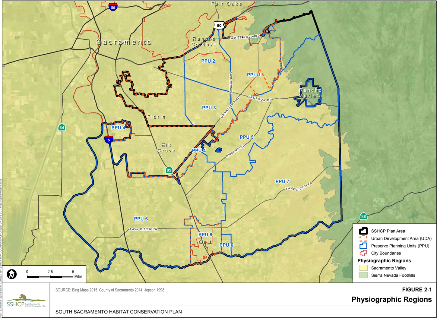
The Plan Area is made up of two physiographic regions (see Figure 2-1). The first is the lower Sacramento Valley, which extends through the western and central parts of the County from north to south. The lower Sacramento Valley region is the predominate region within the Plan Area and is characterized as nearly level to gently rolling, although some areas in the eastern part of the Plan Area are rolling to hilly and the relatively flat terrain is broken up by low and high terrace formations. The second region is the Sierra Nevada foothills, which are located along the northeast edge of the Plan Area. The terrain in this area is characterized as rolling to hilly.
2.3 Geomorphology
Section titled “2.3 Geomorphology”This section presents information on the landforms, geologic formations, and soils that characterize the Plan Area. A discussion regarding geomorphology is important as vernal pools in the Plan Area are largely characterized by these factors.
2.3.1 Landforms
Section titled “2.3.1 Landforms”A landform is a geomorphological unit, and is largely defined by its surface form and location in the landscape (Figure 2-2, Geologic Landforms). As part of the terrain, a landform is an element of topography. Landforms are categorized by characteristic physical attributes such as elevation, slope, orientation, stratification, rock exposure, and soil type. The development of the existing landforms in the Plan Area took place during the Pleistocene and Holocene Epochs. The predominant landforms in the Plan Area are low floodplain, high floodplain, drainageway, low terrace, high terrace, mudflow, hills, and foothills (Jones and Stokes 1990; USDA NRCS 1993; Smith and Verrill 1998). Through a combination of erosion, alternating changes in climate, and pedogenic (soil-forming) processes, vernal pools originated on certain Central Valley landforms. Perhaps most significant in terms of the SSHCP Conservation Strategy are the low terrace and high terrace landforms that contain a majority of the vernal pools within the Plan Area. In an effort to maintain species heterogeneity and achieve the SSHCP Biological Goals and Objectives (see Chapter 7), the SSHCP Conservation Strategy seeks to preserve vernal pools on each landform.
2.3.1.1 Floodplain Landform (Low and High)
Section titled “2.3.1.1 Floodplain Landform (Low and High)”The youngest landform surface in the Plan Area consists of low floodplains. This is an active surface with component landforms that include nearly level tidal and freshwater marshes, natural levees, floodplain splays, and floodplains bordering the Sacramento, American, and Cosumnes Rivers and many smaller channels. Bar and channel topography is evident on the low floodplains along the American River and in a few small areas along the Cosumnes River. The low floodplains are frequently inundated unless they are protected by levees or upstream dams. The landscape is dynamic as new channels are formed and old channels become inactive. Alluvium moving downstream on the low floodplains in the Plan Area has buried older geomorphic surfaces. Upstream from areas where this alluvium is deposited on top of high floodplains, the low floodplains consist of riverwash or channels. Burial of the high floodplains by the low floodplains and the elevation at which the low and high floodplains converge are controlled by the competence and gradient of the stream. The low and high floodplains converge near Sacramento, in an area about 4 miles upstream from the confluence of the Sacramento and American Rivers. High floodplains are an active surface that is somewhat older than that of the low floodplains. Unless protected by levees or upstream dams, the floodplains and basins are occasionally flooded. The components of this surface include backswamps, the edges of backswamps; natural levees, backswamps, and floodplains along the Sacramento River; floodplains along the American and Cosumnes Rivers and other channels; and basins and basin rims in the American Basin. All of these components are nearly level (USDA NRCS 1993; Jones and Stokes 1990; Smith and Verrill 1998).
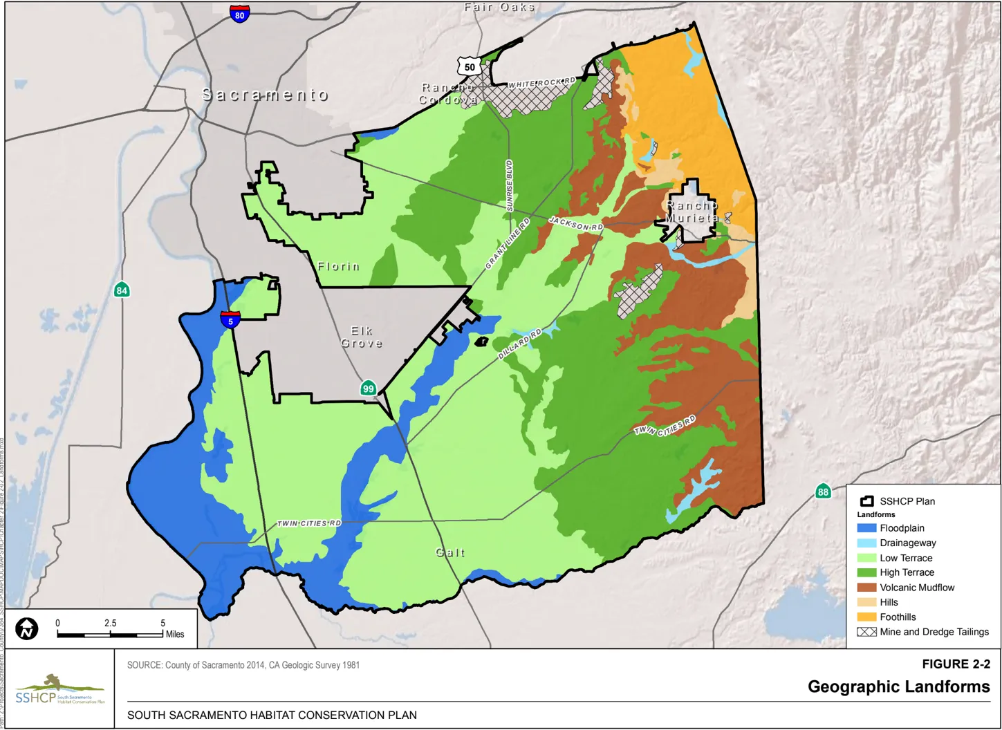
2.3.1.2 Drainageway Landform
Section titled “2.3.1.2 Drainageway Landform”The drainageway landform is composed of relatively recent alluvial deposits at the base of toe slopes and of stream terraces adjacent to incised channels of active waterways, and occur over other geologic formations. These are the second-youngest landform surfaces in the Plan Area, and are present where active streams, creeks, and rivers traverse the other geologic formations found in the Plan Area (discussed below). Consequently, vernal pools that formed on drainageway deposits are often associated with another vernal pool type on the adjacent higher ground and terraces (Jones and Stokes 1990). Because vernal pools on the drainageway landform are interspersed throughout other vernal pool types, they are difficult to map (Jones and Stokes 1990). In contrast to most vernal pools found on the low terrace, high terrace, and mudflow landforms, the vernal pools found on the drainageway landform fill and drain rapidly, and may depend more on overland runoff and direct precipitation to maintain their hydrology (Jones and Stokes 1990). Soils above the restricting claypan or hardpan layers in these pool types may be too deep for perched water tables to become exposed in shallow vernal pools. Additionally, the basins of these types of pools are often shallow, increasing susceptibility to evaporation, or slightly sloped, which encourages drainage.
2.3.1.3 Low Terrace Landform
Section titled “2.3.1.3 Low Terrace Landform”Low terraces (also referred to as “young terrace”), are of relatively recent geologic origin (Jones and Stokes 1990). They contain late Pleistocene-age geomorphic surfaces that are underlain by stream alluvium. Low terrace landforms occur on the broad, nearly level plain of alluvial deposits that make up the Sacramento Valley floor. Low terrace landforms are relatively young (late Pleistocene, 100,000 years ago) when compared to the high terrace or the mudflow landforms (Smith and Verrill 1998). Low terrace soils are not as well developed when compared to high terrace landforms, but have been forming long enough to have undergone significant pedogenesis, and claypans and duripans are common. Vernal pools occur extensively in certain areas of the low terraces. Within the Plan Area, much of the low terrace landform has been converted to agriculture or developed for urban uses. As discussed in Chapter 3, low terrace soils commonly form seasonal ‘perched aquifers.’ Vernal pools found within the low terrace landforms do not exhibit the same richness of flora or specialized species when compared to vernal pools on high terrace landforms (Jones and Stokes 1990). Most young terrace sites have been plowed, graded, or heavily grazed because of their arable soils and proximity to reliable water; this and the relatively young age of the vernal pools may also account for their unspecialized flora in the Plan Area (Jones and Stokes 1990). Many low-terrace pools are shallow or have poorly defined basins. These pools support vernal pool species because they develop on heavy clay Galt soils that retain water in the soil profile for long periods after surface water evaporates (Jones and Stokes 1990).
2.3.1.4 High Terrace Landform
Section titled “2.3.1.4 High Terrace Landform”The high terrace landform (also referred to as ‘old terrace’) is restricted to the east side of the Central Valley (Smith and Verrill 1998; Jones and Stokes 1990; Reiner and Swenson 2000). The high terrace landform was laid down from 600,000 to over 1 million years ago in the mid- to early Pleistocene to late Pliocene, and lies topographically above low terraces. In the Plan Area, high terraces are ancient deposits of the Pleistocene American River, which was located south of its present-day site (Jones and Stokes 1990). Very strong soil development has occurred in relatively flat areas on these terraces where the geomorphic surfaces are very old. The most pronounced erosion-induced mound-depression microrelief and vernal pool landscapes are found on the high terraces. The soils and vernal pools of the high terrace landform have essentially been developing for more than a half-million years. Consequently, the high terrace landform exhibit well-developed soils and floristically rich habitat. Similar to low terrace landform, perched aquifers are common in high terrace landform soils. Vernal pools on high terrace landforms typically support more specialized species than vernal pools found within any other landform (Jones and Stokes 1990). In the Plan Area, the high terrace landform supports the Laguna geological formation and Arroyo Seco gravels. Little of the Arroyo Seco gravels have been farmed because irrigation water is lacking and many sites are not arable. Consequently, vernal pools are abundant on level surfaces. Much of the area with high-terrace pools was dryland farmed in the past with wheat or oats. This activity appears to have had little effect on vernal pools in some areas, such as at the Sunrise-Douglas development area, while elsewhere plowing appears to have disrupted surface hydrology (Jones and Stokes 1990). Old-terrace pools are the oldest and most complex vernal pool type in Sacramento County and have developed a stable, predictable hydrology and flora over a long period.
2.3.1.5 Volcanic Mudflow Landform
Section titled “2.3.1.5 Volcanic Mudflow Landform”The northern Sierra Nevada was covered by extensive volcanic mudflows believed to have arisen east of the sierra crest (Jones and Stokes 1990). These ancient mudflow formations were exposed at the base of the Sierra Nevada foothills, and then overlain by a thin soil derived from alluvial, colluvial material, and the residuum from the mudflow parent material (Jones and Stokes 1990). The mudflow landform ranges in age from early Pleistocene to Oligocene (Smith and Verrill 1998; Jones and Stokes 1990). The mudflow formation exists today as low, nearly level to gently sloping ridges and fans along the eastern edge of the Plan Area. The mudflow formation is characterized by a thin, shallow layer of soil (primarily formed from the parent mudflow material) over impermeable bedrock. In the Plan Area, areas of the mudflow landform support the Mehrten geological formation and the Valley Springs formation. Valley Springs formed in the Oligocene, and Mehrten formed in the Miocene or Pliocene (Jones and Stokes 1990). Soils on the mudflow formation are shallow, extremely rocky, excessively drained by surface runoff and high water infiltration rates, and underlain by impervious mudflow that impedes the downward movement of water and upon which a perched aquifer periodically forms during the wet season (Jones and Stokes 1990).
2.3.1.6 Hill Landform
Section titled “2.3.1.6 Hill Landform”A hill landform has a raised surface above a surrounding level plain, is distinguished by its sloping sides, and defined peak. Hill landforms can be formed through the geologic processes of faulting and erosion. Within the Plan Area, both processes likely played a role in the formation of the hill landform, which is associated with the Pliocene (5 million years ago) uplift of the Sierra Nevada mountains to the east. These processes continue to shape the hill landform in the present. Within the Plan Area, the hill landform can be found in a narrow band immediately west of the foothills. It primarily comprises the Ione Formation, an Eocene-age (55- to 33-millionyear-old) weathered sedimentary sequence (Smith and Verrill 1998; Creely and Force 2007).
2.3.1.7 Foothill Landform
Section titled “2.3.1.7 Foothill Landform”The foothill landform is a surface defined by gradual increase in elevation at the base of a mountain range. They form the transition zone between hills and higher elevation mountains. Within the Plan Area, the foothills comprise the Salt Springs Slate, Copper Hill Volcanics and Gopher Ridge Volcanics geologic formations. The foothill landform is associated with the Pliocene (5 million years ago) uplift of the Sierra Nevada mountains to the east of the Plan Area and is found along the eastern margin of the Plan Area. Uplift from active geologic faults, erosion, and dissection by active stream channels draining the mountain range are the primary forces that shape this landform.
2.3.2 Geologic Formations
Section titled “2.3.2 Geologic Formations”The landforms of the Central Valley and the Plan Area can be further subdivided by specific geologic surficial deposits (formations). A geologic formation is a geomorphic feature on the earth’s surface representative of an episode of landscape development. Geologic formations are differentiated by various criteria, including age, lithology, strata, compaction, texture, depositional history, geomorphology, and soil-profile development (Smith and Verrill 1998). The geologic formations used in the SSHCP are derived from the Geologic Map of the Sacramento Quadrangle prepared by the California State Geological Survey (CGS 1981) (see Figure 2-3, Geologic Formations).
Of the 17 geologic formations that are found within the Plan Area, 15 are known to contain vernal pools. Of the 15 Plan Area geologic formations that contain vernal pools, there are 5 primary geologic formations that contain the majority of vernal pools in the Plan Area and are of particular importance to the development of the SSHCP Conservation Strategy (Chapter 7). They are the Laguna, Riverbank, Modesto-Riverbank, Mehrten, and Valley Springs Formations. The five primary Plan Area vernal pool geologic formations are discussed in the sections that follow by vernal pool acres (the most to the least vernal pool acres).
2.3.2.1 Laguna Formation
Section titled “2.3.2.1 Laguna Formation”The Laguna Formation is part of the high terrace landform (Smith and Verrill 1998; Jones and Stokes 1990; Reiner and Swenson 2000). The Laguna Formation, ranging in age from late Miocene to early Pliocene, rests over the older Mehrten Formation. The Laguna Formation is composed of interbedded alluvial gravel, sand, and silt deposited from ancient river channels draining from the Sierra Nevada range, including the Feather, Yuba, American, Cosumnes, and Merced Rivers (Helley and Harwood 1985).
The Laguna Formation occurs in a band several miles wide running north to south along the eastern half of the Plan Area. The Laguna Formation is exposed in the eastern and central portions of the Plan Area. The formation’s eastern outcrop extends northward from Dry Creek, where its area of exposure is about 6 miles wide, to its northernmost exposure along Meiss Road. Its central outcrop extends northward from Deer Creek to its northernmost exposure along U.S. 50. The Redding soil series and Red Bluff-Redding complex are the characteristic soil series associated with the Laguna Formation north of the Cosumnes River. South of the Cosumnes River to the headwaters of Badger Creek, the Redding series and Red Bluff-Redding complex are the main soils and they give way to Corning and Hadselville-Pentz south of Badger Creek to Dry Creek at the Sacramento-San Joaquin County line.
The Laguna Formation is the second-most extensive geologic formation in the Plan Area, totaling 61,282 acres (23,608 acres are inside the Urban Development Area (UDA) and 37,674 acres are outside the UDA). It comprises just over 19% of the total Plan Area.
The Laguna Formation encompasses 26,684 or 43% of the total number of vernal pools within the Plan Area. Of the 26,684 vernal pools occurring on this formation, 7,734 are located inside the UDA and 18,950 are outside the UDA. The Laguna Formation ranks first in importance in terms of total number of vernal pools. The Laguna Formation supports a wide variety of vernal pool sizes and densities, including some of the greatest vernal pool densities and most of the very large vernal pools remaining within the Plan Area, primarily within the UDA portion of the Plan Area (Dittes et al. 2007). Dittes et al. 2007 also found significantly lower density of vernal pools, smaller sizes of individual vernal pools, and a different category of ‘vernal pool complexes’ on Laguna Formation soils located outside of the SSHCP UDA when compared to vernal pools on Laguna Formation soils inside the SSHCP UDA. Approximately 34% (1,554 acres) of the total vernal pool acreage within the entire Plan Area occurs on the Laguna Formation. There are 603 acres of vernal pool within the UDA and 951 acres outside the UDA.
2.3.2.2 Riverbank Formation
Section titled “2.3.2.2 Riverbank Formation”The Riverbank Formation is part of the low terrace landform. The Riverbank Formation was deposited on a plain of stream alluvium that has been partially dissected. The upper surface of this plain, in most places, represents the upper surface of the Riverbank Formation. The upper surface is characterized by a gently undulating surface. In the vicinity of Elk Grove, the Riverbank Formation is about 10 miles wide from west to east. To the east, it laps onto older materials composed of the Laguna Formation. To the west, it is in turn overlain by younger alluvial materials. Riverbank Formation is generally confined to the central and western portions of the Plan Area and occurs on either side of the Cosumnes River. Soils with claypans and duripans are common, as are vernal pools (Smith and Verrill 1998). The San Joaquin soil series is most closely associated with the Riverbank Formation. Other associated soil series in the Plan Area include Redding, Red Bluff, and Corning. Inclusions of Tehama soil with vernal pools on the low terrace landform are unusual; the only site in the study area, east and west of the intersection of Carbondale and Ione Roads and north of Willow Creek, is surrounded by old-terrace and mudflow pool areas (Jones and Stokes 1990).
The Riverbank Formation is the largest geologic formation in the Plan Area, with a total of 122,228 acres (35,401 acres inside the UDA and 86,827 acres outside the UDA). It comprises just over 38% of the total Plan Area. Although the Riverbank Formation dominates the Plan Area, large portions have been converted for agriculture or developed for urban uses because of their arable soils and proximity to reliable water. Consequently, young-terrace pools are not as common as the extent of the Riverbank Formation might suggest. In addition, most undeveloped portions of the Riverbank Formation were plowed or leveled in the past, further reducing the extent of intact young-terrace pools, and altering species composition and cover (Jones and Stokes 1990).
The Riverbank Formation encompasses 12,367 or 20% of the total number of vernal pools within the Plan Area. Of the 12,367 vernal pools occurring on this formation, 2,800 are located inside the UDA and 9,567 are outside the UDA. The Riverbank Formation ranks second in total number of Plan Area vernal pools.
Approximately 34% (1,533 acres) of the total vernal pool acreage within the entire Plan Area occurs on the Riverbank Formation. There are 289 acres of vernal pool within the UDA and 1,244 acres outside the UDA.
2.3.2.3 Mehrten Formation
Section titled “2.3.2.3 Mehrten Formation”The Mehrten Formation is part of the mudflow landform, and consists of eroded, high-standing remnants of andesitic volcanic mudflow fans that were deposited during the Pliocene and Miocene, 10-25 million years ago. Vernal pools tend to be located on the western edge of the Mehrten Formation because the eastern portion increases in slope, precluding pool development (Smith and Verrill 1998). As discussed in Chapter 3, vernal pools classified as Northern Volcanic Mudflow Vernal Pools are often found on Mehrten Formation soils. Several outcrops of the Mehrten Formation are exposed in a discontinuous band that runs north-south in the eastern portion of the Plan Area in a stratum that underlies the Laguna Formation and overlies the Valley Springs Formation. The exposed band of Mehrten Formation extends from the south county boundary at Dry Creek, where it is about 4 miles wide, north to U.S. 50, where it is less than a mile wide. In the Plan Area, the Mehrten Formation is characterized by the moundintermound soil series and complexes such as Hadselville-Pentz, Red Bluff-Redding, CorningRedding, and Pardee-Rancho Seco soil complex. The Corning-Redding and Red Bluff-Redding complexes are predominant north of the Cosumnes River, while the Hadselvill-Pentz and PardeeRancho Seco complexes are predominant south of the Cosumnes River.
The Mehrten Formation is divided into two different layers. One is a sedimentary unit composed of gray to black andesitic sands, interbedded bouldery gravels, and blue to brown clay. Frequently laminated, the beds of black sand are commonly about 5 feet thick, although beds of up to 20 feet or more have been reported. Associated with the black sands are beds of stream gravel containing andesitic cobbles and boulders of up to several feet in diameter and beds of brown to blue clay and silt.
The second major unit of the Mehrten Formation is the tuff breccia. This rock is very dense and hard. It is composed of angular pieces and blocks of black, gray, and red fine-grained to porphyritic andesite, which range from less than an inch to over several feet in diameter. The tuff breccia was derived from andesitic eruptions to the east in the Sierra Nevada. During these eruptions, great quantities of highly mobile ash flowed west down the then-existing stream channels and picked up blocks of andesite debris, which were incorporated into the mass. The mass spread out over the westward-sloping plains and solidified as a pavement of hard, concretelike rock, which ranged from only a few feet to over 30 feet in thickness. Flow patterns are readily evident where the upper surface of the tuff breccia is now exposed. On this surface, soil cover is scant, with the blocks of andesite standing out in bold relief, giving the appearance of a boulder-strewn field. Run-off from precipitation is nearly 100% due to the rocky surface.
The Mehrten Formation covers the third-largest geologic formation in the SSHCP, with a total of 26,459 acres (3,863 acres inside the UDA and 22,596 acres outside the UDA). It comprises just over 8% of the total Plan Area.
The Mehrten Formation encompasses 10,275 or about 17% of the total number of vernal pools within the Plan Area. Of the 10,275 vernal pools occurring on this formation, 648 are located inside the UDA and 9,627 are outside the UDA. The Mehrten Formation ranks third in importance in terms of total number of vernal pools.
Approximately 11% (478) of the total vernal pool acreage within the entire Plan Area occurs on the Mehrten Formation. There are 32 acres of vernal pool on the Mehrten Formation within the UDA and 446 acres on the Mehrten Formation outside the UDA.
2.3.2.4 Modesto-Riverbank Formations
Section titled “2.3.2.4 Modesto-Riverbank Formations”The Modesto-Riverbank Formations are dominantly andesitic, late- to middle-Pleistocene alluvium composed of gravel, sand, silt, and clay derived from the Tuscan Formation via various streams (CGS 1981). The Modesto-Riverbank Formations are generally confined to the eastern portion of the Plan Area forming on either side of Laguna Creek (south) and its tributaries and on either side of Dry Creek. Widths vary from approximately a quarter of a mile wide along the tributaries of Laguna Creek (south) to about 1 mile wide along the main channel of Laguna Creek and Dry Creek. These formations extend west from the boundary with Amador County to a nondescript area east of the City of Galt. There are a number of soil series that are associated with the ModestoRiverbank Formations, including, but not limited to, the Corning complex, Hicksville loam, Madera loam, Redding gravelly loam, and Tehama loam (CGS 1981).
The Modesto-Riverbank Formations cover the fifth-largest area in the SSHCP, with a total of 14,688 acres (567 acres inside the UDA and 14,121 acres outside the UDA). It comprises nearly 5% of the total Plan Area.
The Modesto-Riverbank Formations encompass 5,272 or about 9% of the total number of vernal pools within the Plan Area. All 5,272 vernal pools occurring on this formation are outside of the UDA. The Modesto-Riverbank Formations rank fourth in importance in terms of total number of vernal pools.
Approximately 11% (503 acres) of the total vernal pool acreage within the entire Plan Area occurs on the Modesto-Riverbank Formations. All 503 acres are found outside of the UDA.
2.3.2.5 Valley Springs Formation
Section titled “2.3.2.5 Valley Springs Formation”The Valley Springs Formation is also part of the mudflow landform, but is slightly older than the Mehrten Formation. The Valley Springs Formation is made up of eroded, high-standing remnants of rhyolitic volcanic mudflow fans that were deposited 20-35 million years ago. Vernal pools tend to be located on the western edge of the formation because the eastern portion increases in slope, precluding pool development (Smith and Verrill 1998). The Valley Springs Formation is exposed along the southeastern portion of the Plan Area from the southeastern corner along Dry Creek, northward to the headwaters of Carson Creek. The formation is generally exposed over an area from 1 to 2 miles in width. Its widest exposure is along Arkansas Creek, where it is exposed for about 4 miles from east of Ione Road, west to the Cosumnes River. There may be expansible clays present, especially in fine-grained material. The Amador-Gillender, Hadselville-Pentz, and Pardee-Rancho Seco soil complexes predominate on the Valley Springs Formation.
The Valley Springs Formation is the seventh-largest geologic formation exposed in the SSHCP, with a total of 13,690 acres (141 acres inside the UDA and 13,549 acres outside the UDA). It comprises just over 4% of the total Plan Area.
The Valley Springs Formation contains 4,139 vernal pools, or about 7% of the total number of vernal pools within the Plan Area. Of the 4,139 vernal pools occurring on this formation, 10 are located inside the UDA and 4,129 are outside the UDA. The Valley Springs Formation ranks fifth in importance in terms of total number of Plan Area vernal pools.
Approximately 6% (265 acres) of the total vernal pool acreage within the entire Plan Area occurs on the Valley Springs Formation. With the exception of 0.16 acre, almost all of the vernal pool acreage on this formation occurs outside of the UDA.
2.3.3 Soils
Section titled “2.3.3 Soils”Many different kinds of soils are found within the Plan Area with a wide range of characteristics that influence flora and fauna habitat suitability, including soil wetness, depth to rock, the presence of hardpans, tight layers, erodibility, clay content, and soil slopes. Soils in the Plan Area vary from very deep, nearly level alluvial soils, to undulating shallow soils over restrictive duripans or clayrich soil horizons, to shallow hilly soils overlying bedrock. These soils also vary from well-drained to poorly drained mineral soils and, to a lesser extent, organic soils. Individual soil units are organized into map units called soil associations, which consist of soil units of the same texture and composition that occur in a geographic position (USDA NRCS 1993). Soils data were used to help define Covered Species modeled habitat (Chapter 3). Soils series that contain vernal pools include an impermeable layer, which can be a claypan, a cemented hardpan (duripan), or rock (Solomeshch et al. 2007).
Soil series are commonly used as part of the name for an area shown on a soil survey map where that series is dominant. Certain soil series have been consistently mapped as the dominant soil in areas that coincide with the occurrence of vernal pools. Most of these soil series are associated one-to-one with geologic formations, although some series may occur on two or more formations. For example, the San Joaquin soil series, a Durixeralf that has been nominated as the California State Soil, is the most extensive soil series mapped in vernal pool areas, covering almost a half-million acres of low terraces on the east side of the Central Valley. The San Joaquin soil is the principal soil that defines the low terrace Riverbank Formation.
The Redding soil series, a more weathered and gravelly Durixeralf that is the second-most extensive soil series mapped in vernal pool terrain at almost 200,000 acres, primarily defines the Laguna Formation on the eastside of the Central Valley. The Corning soil series is a Palexeralf associated with the Redding series on both the Laguna and Red Bluff Formations on high terraces.
A number of soil series occur as interwoven complexes in a landscape. In some moundintermound vernal pool landscapes, soil series complexes are differentiated with one series on the mounds and the other in the intermounds. Examples are the mound Pentz soil series and the intermound Hadselville soil series (Smith and Verrill 1998).
The following provides a brief description of the six most prominent soil series within the Plan Area, organized by highest to lowest in elevation on the landscape.
2.3.3.1 Mudflow Soils
Section titled “2.3.3.1 Mudflow Soils”Hadselville
Section titled “Hadselville”The Hadselville series consists of very shallow loamy, moderately well-drained intermound soils formed in material weathered from weakly consolidated basic andesitic tuffaceous sediments primarily from the Mehrten Formation on exposed, upturned edges of mudflow formations at the base of the Sierra Nevada foothills (Jones and Stokes 1990). The Hadselville and Pentz soils are on hills with a mound-intermound microrelief topography. Hadselville soils are in the intermound position, and slopes are 2% to 30%.. Soil depth ranges from 4 to 10 inches. The restrictive layer is bedrock. The soil is dry at the bottom depth in most years for a period of 120 to 150 days from May 15 to October 1, moist in all parts for a period of 135 to 165 days from November 15 to April 15, and moist in some part the rest of the year. The mean annual soil temperature is 64°F to 67°F and the temperature remains above 47°F throughout the year. Organic matter content ranges from 1% to 2% throughout the profile and is higher than the underlying material. Hadselville soils are acidic (with a pH of 5-6.5), with a low cation exchange capacity leading to very poor soil nutrient conditions. This soil is influenced by small amounts of ash inherited from the parent material. Elevation is 110 to 350 feet above mean sea level (amsl). These soils formed in material weathered from consolidated tuffaceous sediments of the Mehrten Formation. The sediments are dominantly composed of basic andesitic sands that are stratified with conglomerate or andesite coarse fragments in some areas. Strongly consolidated strata may outcrop as bands across a hillslope.
The Hadselville soil is very shallow and moderately well drained. It formed in material weathered from weakly consolidated basic andesitic tuffaceous sediments. Typically, the surface layer is grayish-brown sandy loam about 7 inches thick. Weakly consolidated tuffaceous sandstone is at a depth of about 7 inches. In some areas, the surface layer is gravelly sandy loam. In other areas, a thin hardpan caps the bedrock. Permeability is moderately rapid in the Hadselville soil. Available water capacity is very low. The effective rooting depth and the depth to weakly consolidated bedrock are 4 to 10 inches. Runoff is very slow or medium. The hazard of water erosion is slight or moderate.
The Pentz series consists of shallow loamy, well-drained soils formed in material weathered from weakly consolidated basic andesitic tuffaceous sediments primarily from the Mehrten Formation on exposed, upturned edges of mudflow formations at the base of the Sierra Nevada foothills (Jones and Stokes 1990), and supporting primarily annual grassland that formed in material weathered from weakly consolidated basic andesitic tuffaceous sediments. Pentz soils form mound, intermound microrelief and are found on hills and on backslopes of hills. Pentz soils are on the mound position. Slopes are 2% to 50%. Depth to paralithic contact and thickness of the solum is 10 to 20 inches. The restrictive layer is bedrock. The soil is dry between a depth of 8 inches and the paralithic contact in most years from May 15 to October 15 is moist in all parts from December 1 to May 1 and moist in some part the rest of the year. The mean annual soil temperature varies from 64°F to 67°F and the temperature remains above 47°F throughout the year. The weighted average clay content of the particle-size control section ranges from 10% to 20%. Coarse fragments are subrounded or rounded metamorphic rock, quartz, or quartzite. Content of coarse fragments is 0% to 35% with 0% to 25% cobbles or stones. Organic matter in the upper 7 inches mixed is 1% to 3%. Pentz soils are acidic (with a pH of 5-6.5) with a low cation exchange capacity leading to very poor soil nutrient conditions. This soil is influenced by small amounts of ash inherited from the parent material. Pentz soils are on undulating to hilly hills and on steep backslopes of hills, with mound-intermound microrelief. The microrelief is most strongly expressed on slopes of less than 20%. Slopes are convex or plane and are 2% to 50%. Elevation is 110 to 600 feet amsl. The soils formed in material weathered from consolidated tuffaceous sediments of the Mehrten Formation. The sediments are dominantly composed of basic andesitic sands that are stratified with conglomerate or andesitic coarse fragments in some areas. Strongly consolidated strata may outcrop as bands across a hill slope.
The Pentz soil is shallow and well drained. It formed in material weathered from weakly consolidated basic andesitic tuffaceous sediments. Typically, the surface layer is brown fine sandy loam about 9 inches thick. The subsoil also is brown fine sandy loam. It is about 7 inches thick. Weakly consolidated tuffaceous sandstone is at a depth of about 16 inches. In some areas, the surface layer is gravelly sandy loam, sandy loam, or loam. In other areas, a thin hardpan caps the bedrock. Permeability is moderately rapid in the Pentz soil. Available water capacity is low. The effective rooting depth and the depth to weakly consolidated bedrock are 10 to 20 inches. Runoff is medium. The hazard of water erosion is slight or moderate.
2.3.3.2 Low Terrace Soils
Section titled “2.3.3.2 Low Terrace Soils”San Joaquin
Section titled “San Joaquin”The San Joaquin soil series is the most extensive vernal pool soil. This series, plus others with which it is geographically associated (e.g., Fiddyment, Galt, Madera, and Rocklin), developed on Riverbank-age alluvial terraces along the eastern flank of the Central Valley (in the later Pleistocene, 100,000 to 200,000 years old). This soil series is the oldest continuously recognized soil series within the State of California, yet is the youngest of the Plan Area vernal pool soils geologically. These soils are used for irrigated crops, such as wheat, rice, figs, almonds, oranges, and grapes, and for pasture and urban development. San Joaquin soils formed in old alluvium on hummocky topography. A cemented hardpan (duripan) a few feet beneath the surface restricts roots and water percolation. San Joaquin soils are classified in U.S. Department of Agriculture (USDA) soil taxonomy as fine, mixed, active, thermic abruptic durixeralfs. The San Joaquin series is a loamy mineral soil supporting primarily annual grassland. The soil series consists of moderately deep to a duripan, well and moderately well-drained soils that formed in alluvium derived from mixed but dominantly granitic rock sources. They are on undulating low terraces with slopes of 0% to 9%. San Joaquin soils range from acidic (pH of 5) to mildly alkaline (pH of 8) with a low cation exchange capacity, resulting in generally nutrient-poor soil conditions. Some areas have been leveled. San Joaquin soils account for approximately 17% of soils within Sacramento County and San Joaquin soil complexes comprise an additional 8%, for a total of approximately 25% of Sacramento County. San Joaquin soils are the predominant soil series on the Riverbank Formation occurring on both the high floodplain and low terrace landforms in the County. San Joaquin soils occur in soil complexes with Galt soils, durixeralfs, xerarents, and urban land. San Joaquin soils and associated complexes all have a duripan ranging from 2 to 4 feet below soil surface. Vernal pools tend to form in mound-intermound areas and depressional features within these soil series. Together, the San Joaquin, Redding, and Corning soil seriesdurixeralfs and palexeralfs-are the core Northern Hardpan Vernal Pool soils. However, there are several dozen additional soil series (but of more limited distribution) that share the ironsilica-cemented duripan, reddish color, landscape position, and depleted nutrient status that characterize Northern Hardpan Vernal Pool soils (Solomeshch et al. 2007).
2.3.3.3 High Terrace Soils
Section titled “2.3.3.3 High Terrace Soils”Redding
Section titled “Redding”Redding and Corning soil series developed on older, higher alluvial terrace landforms of the Laguna Formation (Pliocene to early-Pleistocene age). The Redding soil series is a well-drained, gravelly loam mineral soil that is moderately deep over a hardpan and supports primarily annual grassland. It formed in gravelly old valley fill from mixed sources but primarily derives from the Laguna Formation. Typically, the surface layer is strong brown and yellowish-red gravelly loam and reddish-brown loam about 14 inches thick. The subsoil is dark reddish brown and reddishbrown clay. The hardpan ranges occur at a depth of 2 to 4 feet below surface level. Permeability is very slow. Redding soils are moderately acidic (pH 5-6.5) with a low cation exchange capacity resulting in generally nutrient-poor soil conditions. The available water capacity is 1.5 to 3.0 inches. The effective rooting depth is 20 to 34 inches. Most roots in the clay subsoil are along the faces of peds, which reduces the water available to plants. Surface runoff is slow or medium. The hazard of erosion is slight or moderate. After intense rainstorms, the soil is saturated for a short time. They are on nearly level or dissected and undulating to hilly high terraces. Slopes are 0% to 30%.
The soil between depths of 4 and 18 inches is usually dry all of the time from June until September or early October, and is moist in some or all parts the rest of the year. Weighted average clay content of the upper 20 inches of the argillic horizon is 35% to 60%. Redding soils are on nearly level or dissected and undulating to hilly high terraces. Microrelief may be hummocky. Gravel and cobbles tend to concentrate in the intermound in hummocky areas. Vernal pools with relief that is greater than the intermound are common in areas with slopes of 0% to 3%. Elevations are 40 to 2,000 feet amsl. The soils formed in stratified alluvium of mixed sediments that are gravelly or cobbly. These sediments vary considerably over short distances and may be unrelated to the overlying soil.
The Redding soil is moderately deep and moderately well drained. It formed in gravelly and cobbly alluvium derived from mixed rock sources. Typically, the surface layer is strong brown gravelly loam about 7 inches thick. The upper part of the subsoil is yellowish-red loam and gravelly loam. The lower part is a claypan of reddish brown and yellowish-red gravelly clay about 8 inches thick, at about 20 inches depth. Below this to a depth of 66 inches is a very gravelly hardpan that is strongly cemented with silica. Therefore, the Redding soil series restrictive layer is both claypan and hardpan. In some areas, the surface layer is gravelly sandy loam, loam, or sandy loam. Permeability is very slow in the Redding soil. Water is perched above the claypan/hardpan for short periods after heavy rainfall in winter and early spring. Available water capacity is low. The effective rooting depth is 20 to 40 inches, but roots are restricted to the cracks and faces of peds in the claypan, which is at a depth of 17 to 30 inches. The depth to a hardpan is 20 to 40 inches. The shrink-swell potential is high. Runoff is very slow or slow. The hazard of water erosion is slight. This soil is used as rangeland or for dryland crops, such as wheat. It may provide wetland functions and values. These should be considered when plans are made for enhancement of wildlife habitat or for land use conversion. Redding soils account for approximately 6% of Sacramento County, predominately in the eastern portion of the County. Redding soils are the predominate soil series occurring on the Laguna Formation on low and high terraces. Redding soils occur often in complexes with Red Bluff and Corning soils and Xerarents. Together, the San Joaquin, Redding, and Corning soil series-durixeralfs and palexeralfs-are the core Northern Hardpan Vernal Pool soils (Solomeshch et al. 2007).
Red Bluff
Section titled “Red Bluff”The Red Bluff series consists of very deep, well-drained loamy mineral soils formed in high (older) terraces of the Laguna Formation. Red Bluff soils are on high terraces and have 0% to 9% slopes in elevations of 75 to 1,500 feet amsl. Thickness of the solum is over 60 inches and the percentage of clay decreases from the maximum amount at 60 inches by 3% to 10% absolute. The mean annual soil temperature is 62°F to 66°F and exceeds 41°F all year. The soil between a depth of 7 and 21 inches is dry in all parts from June to October and moist in some or all parts the rest of the year. The upper 20 inches of the argillic averages more than 35% clay and ranges from 27% to 60% clay. Base saturation (sum) ranges from 45% to 75% throughout the argillic horizon. Red Bluff soils are among the oldest soils in the County. Their base saturation is as low as 45% in the argillic horizon and is even lower in the surface layer. Parent materials for Red Bluff soils are gravelly and cobbly alluvium from mixed sources. The restrictive layer is claypan at a depth of approximately 35 inches (Jones and Stokes 1990). Paleoclimatic influence also is indicated by properties of the Red Bluff soils. A high content of clay, reddish color, low pH (56.5), and a significant amount of iron and manganese staining distinguish these soils from other soils in the Plan Area. Low to moderate cation exchange capacity leads to generally nutrientpoor soil conditions. Presumably, a warmer and perhaps wetter paleoclimate influenced the weathering of clay minerals in the Red Bluff soils to kaolinite. Good subsurface drainage and the parent material also were factors.
The well-drained Red Bluff soils are dominant on the high and intermediate terraces. These mature soils have a thick, deeply weathered argillic horizon and a low base saturation. They have a slightly higher reaction in the A and B horizons than is typical for the Red Bluff series, which generally consists of older soils on high terraces. The parent material of the Red Bluff soils is gravelly alluvium derived from fluvial and glacial sources and laid down by an ancestral channel of the American River. It consists of rounded pebbles and cobbles derived from mixed sources, including dark metamorphic, quartzitic, and andesitic rocks in a granitic sand matrix. These American River channel pebbles are approximately 600,000 years old, as regionally correlated from radiometrically dated sediments of a stratigraphic unit in the San Joaquin Valley. Consequently, they are of mid-Pleistocene age. Soils on hills in the eastern part of Sacramento County also are estimated to be of mid-Pleistocene age.
Corning
Section titled “Corning”Corning soils are gravelly loam formed from the Laguna Formation and Arroyo Seco gravels on high terraces and terrace remnant landforms. Corning soils are characterized by mound-intermound microrelief and on smooth terrace side slopes. They are very deep. They are well drained on the mounds and moderately well drained in the intermound areas. Typically, the surface layer is gravelly fine sandy loam. The restrictive layer is a claypan at approximately 28 inches depth (Jones and Stokes 1990). The substratum is stratified gravelly sandy clay loam and gravelly sandy loam. It formed in old valley fill from mixed sources. Typically, the surface layer is reddish-brown, yellowish-red, and red gravelly loam about 22 inches thick. The subsoil is red and dark red clay about 18 inches thick. The substratum to a depth of 60 inches is strong brown clay loam. Corning soils can range from acidic to mildly alkaline (pH of 5-8.5) with a low cation exchange capacity resulting in generally nutrient-poor soil conditions. Permeability is very slow. The available water capacity is 4.0 to 6.5 inches. The effective rooting depth is 60 inches or more, but most roots in the clay subsoil are along the faces of peds, which reduces the water available to plants. Surface runoff is slow or medium. The hazard of erosion is slight or moderate. After intense rainstorms, the soil is saturated for a short time. The Corning series consists of very deep, well, or moderately well-drained soils formed in gravelly alluvium weathered from mixed rock sources. Corning soils are on high terraces and show moundintermound microrelief. Slopes are 0% to 30%. Solum thickness is 23 to 60 inches. Soil temperature is greater than 47°F throughout the year. Solum thickness differs over short distances because of hummocky microrelief. Elevations are 75 to 1,300 feet amsl. Slopes are 0% to 30%. The soils formed in gravelly alluvium derived from mixed rock sources.
The well-drained Corning soil is very deep. It formed in gravelly alluvium derived from mixed rock sources. Typically, the surface layer is about 28 inches of strong brown gravelly loam and yellowish-red loam. The subsoil is a claypan of yellowish-red gravelly clay loam about 19 inches thick. The substratum to a depth of 62 inches is yellowish red, stratified gravelly loamy coarse sand to gravelly sandy clay loam. In some areas, the surface layer is gravelly sandy loam, loam, or sandy loam. In other areas, the subsoil and substratum are very gravelly. In places, the subsoil is clay or clay loam. Permeability is very slow in the well-drained Corning soil. Water is perched above the claypan for very brief periods after heavy rainfall in winter and early spring and when the soil is over-irrigated. Runoff is medium. The hazard of water erosion is slight or moderate.
The moderately well-drained Corning soil is very deep. It formed in gravelly alluvium derived dominantly from mixed rock sources. Typically, the surface layer is brown gravelly fine sandy loam and reddish-brown, yellowish-red, and light-brown loam, which extends to a depth of about 20 inches. The subsoil is a claypan of yellowish-red clay about 12 inches thick. The substratum to a depth of 60 inches is yellowish-red, stratified gravelly sandy clay loam to gravelly sandy loam. In some areas, the surface layer is gravelly loam, sandy loam, or loam and the subsoil and substratum are very gravelly. In other areas, the subsoil does not have coarse fragments and is grayish-brown clay and clay loam. Available water capacity is low. The effective rooting depth is more than 60 inches, but roots are restricted to the cracks and faces of peds in the claypan, which is at a depth of 15 to 30 inches. Together, the San Joaquin, Redding, and Corning soil series-durixeralfs and palexeralfs-are the core Northern Hardpan Vernal Pool soils (Solomeshch et al. 2007).
2.4 Atmospheric Conditions
Section titled “2.4 Atmospheric Conditions”The climate of the Sacramento region is generally described as being Mediterranean and subtropical. Mediterranean climates are characterized by hot, dry summers and cool, moist winters. The absence of any major physiographic variations within the Plan Area results in a nearly uniform climate for the entire area, with the exception of the Sacramento-San Joaquin Delta, where cooler ocean breezes keep summer temperatures lower than in the remainder of the County. It is this seasonal regime that allows vernal pools to persist within the Plan Area and provides a favorable environment for agriculture that supports many SSHCP bird Covered Species.
Temperatures and Growing Season
Section titled “Temperatures and Growing Season”Temperatures in July vary from an approximate average daily high of 94°F to an average daily low of 60°F, while temperatures in January vary from an approximate average daily high of 54°F to an average daily low of 40°F. Extreme temperatures in Sacramento County have been recorded as low as 17°F in December of 1932 and as high as 114°F in July of 1925 (Masters-Bevan 2000).
Sacramento County has a long growing season. The growing season is that period of time when the temperature is above 32°F. The growing season in Sacramento County ranges from 250 days in or near the Sierra foothills to over 300 days near the City of Sacramento. Most of the lands being cultivated in the County enjoy a growing season of approximately 275 days a year.
Precipitation and Snowfall
Section titled “Precipitation and Snowfall”Generally, summers in Sacramento County are dry and winters are moist. Total average rainfall in Sacramento County measures about 19 inches annually. Just over half of the total amount of yearly rainfall occurs during the winter rainy season, which is from November to February. During that period, measurable quantities of precipitation occur, on average, 10 days out of every month. Thunderstorms are rare, but when they do occur, it is usually in the fall, late spring, or late summer. Snowfall is also rare in Sacramento County, and when it does occur, the amount is small and melts quickly (Masters-Bevan 2000).
The County experiences a great deal of sunshine throughout the year. During the winter months, about 53% of the days have sunshine, while sunshine will prevail on about 95% of the days during the summer months. A typical year in Sacramento reports 188 clear days, 77 partly cloudy days, and 100 cloudy or foggy days (Masters-Bevan 2000).
Winds in Sacramento County are influenced in most instances by the cool marine air entering the Central Valley through the Carquinez Straits. Because of the north-south orientation of the Great California Valley, the winds advancing from the sea to the west, once in the valley, change direction and blow either north toward Sacramento County or south toward San Joaquin County, depending upon existing atmospheric pressures.
Southerly winds prevail in Sacramento County, with an average velocity of about 8 miles per hour. On occasion, this south wind does not extend across the entire valley floor but, instead, a light northerly counter-current may occur on the west side of the valley.
In winter, the wind directions are generally dependent upon the passage of frontal systems through the valley. Southeasterly winds generally occur as a front approaches, with a marked wind shift to the northwest or north after the front has passed. The strongest northerly winds occur after the front has passed, decreasing in speed over a period of a few days.
Air movement may stagnate between storms in winter, but the highest frequency of stagnation occurs in autumn, during the period after the characteristic summer flow ceases and before the season of winter storms has commenced. During any season, nighttime cold density flows may occur in the absence of strong barometric pressure gradients. These flows are most pronounced in sloping mountain valleys and tend to follow water drainage patterns.
These density flows lead to a pooling of cold air with a temperature inversion at the top of the pool; thus, any radiation inversion that might occur independently on the valley floor may be augmented by cold air flowing off of the sloping sides of the valley.
Humidity and Fog
Section titled “Humidity and Fog”Generally, summers in Sacramento County are dry and winters are moist. The relative humidity ranges from about 30% to 80% during summer months and 60% to 90% during winter months (Masters-Bevan 2000).
Heavy fog, locally called radiation fog or ‘tule fog,’ is experienced in the Plan Area during the winter months, usually December to February, with a higher occurrence along waterways. Several conditions, occurring simultaneously, are conducive to the formation of radiation fog. These include the lack of strong storm systems, an intensifying nighttime inversion caused by cold down-slope drainage flows from the mountains, and short daylight hours. Radiation fog frequently occurs during the nights and mornings and ranges in thickness from 200 feet in lower elevations of the valley to just 10 feet at higher elevations. Fog may persist for periods of several days to 2 or 3 weeks in the absence of a strong weather system, or if solar radiation that normally heats the ground is reflected back into the atmosphere by the fog itself. On average, fog occurs in Sacramento County 34 days per year (Cunningham 2003).
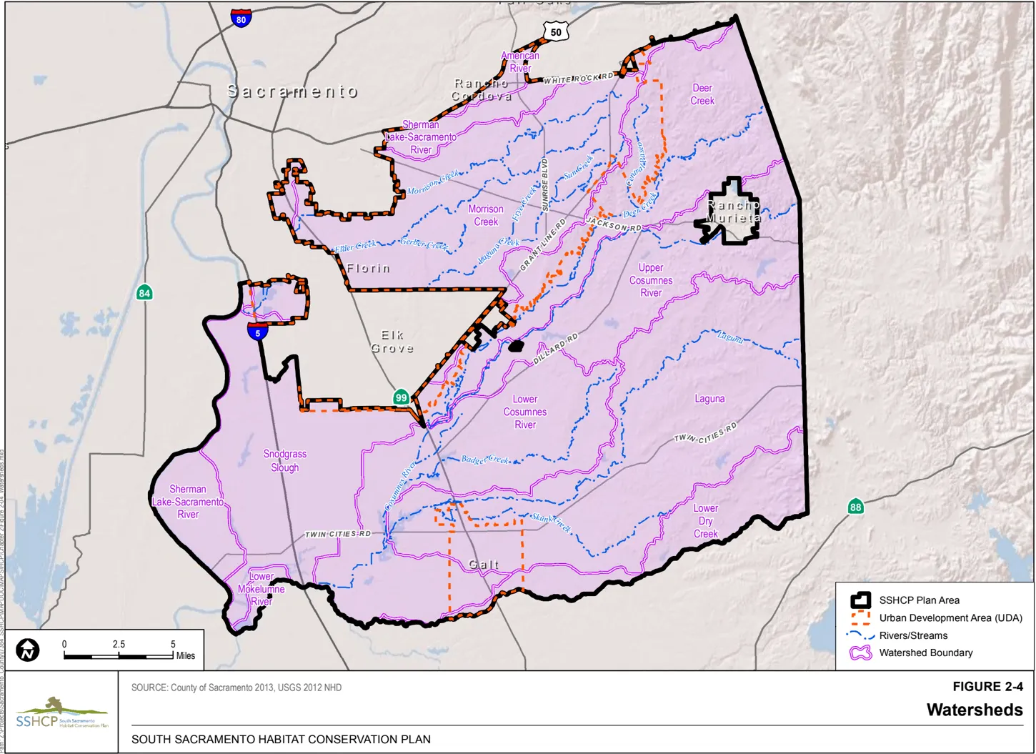
2.5 Surface Waters
Section titled “2.5 Surface Waters”As discussed in Section 2.3.1, Landforms , the easterly and center portion of the Plan Area has rolling terrain, resulting in reasonably well-defined stream channels and steep gradients. The westerly portion of the Plan Area, on the other hand, generally comprises landforms typical of the Central Valley floor with level terrain and poorly defined, meandering streams with gentle gradients. The general pattern of drainage, slope, and gradient in the Plan Area is from northeast to southwest.
Hydrologic conditions of most streams and rivers in the Plan Area are altered from historic conditions. Historically, the hydrology of most streams within the Plan Area was intermittent or ephemeral. The streams would flow in the winter and spring months when precipitation and groundwater conditions were suitable. Under current conditions, summer runoff from various land uses provides augmenting flows to many segments of Plan Area streams, sometimes creating perennial hydrology.
The Cosumnes River and the Mokelumne River are the only rivers within the Plan Area, though the southern border of the Plan Area is the centerline of the Mokelumne River and the western border of the Plan Area is adjacent to the Sacramento River (see a description of the Plan Area in Chapter 1 (Figure 1-1, SSHCP Plan Area)). The Cosumnes River receives flows from its contributing stream tributaries, and flow is also naturally augmented through connection to shallow groundwater basins.
Most of the perennial and larger intermittent streams, creeks, and rivers within the Plan Area are named flowline features. Although some riparian and adjacent wetland habitats are intact and/or being restored in certain locations, the dominant SSHCP land cover types (see Chapter 3) adjacent to named rivers and streams are Valley Grassland, Agricultural, and Non-Habitat land cover types associated with urban development. Some of these streams are channelized, rerouted around agricultural operations, and devoid of riparian areas as a result of agricultural and urban/suburban development.
2.5.1 Important Rivers, Streams, and Creeks within the UDA
Section titled “2.5.1 Important Rivers, Streams, and Creeks within the UDA”The following describes specific rivers, streams, and creeks within the UDA that were studied for potential benefits to Covered Species or water quality should they be preserved under this Plan (see Figure 2-4, Watersheds).
2.5.1.1 Central Paseo
Section titled “2.5.1.1 Central Paseo”The headwaters to the Central Paseo are located in an undescribed portion of the Plan Area proximal to the northeast corner of the SSHCP’s UDA. From its headwaters, the stream flows south through Valley Grassland land cover for approximately 36,160 feet within the Cordova Hills Master Plan Area before intersecting Deer Creek. As of the writing of this Plan, there are no portions of the Central Paseo within existing preserves.
2.5.1.2 Elder Creek
Section titled “2.5.1.2 Elder Creek”The headwaters to Elder Creek are located within the Jackson Township Master Plan Area near the intersection of Kiefer Road and Eagles Nest Road. From its headwaters, the stream flows southwest through a matrix of Valley Grassland and agricultural-residential development for approximately 44,560 feet until it reaches Elk Grove Florin Road. This section of the stream largely retains its natural meander, only occasionally being interrupted in small sections where it has been straightened and widened to accommodate agricultural operations, including a large nursery. From Elk Grove Florin Road, the stream continues for approximately 18,740 feet through an urbanized setting before leaving the Plan Area. The portion of Elder Creek that flows through this urban setting is concrete-lined or riprapped with little or no riparian vegetation remaining. As of the writing of this Plan, there are no portions of Elder Creek within existing preserves.
2.5.1.3 Frye Creek
Section titled “2.5.1.3 Frye Creek”The headwaters to Frye Creek are located within the New Bridge Master Plan Area proximal to the intersection of Kiefer Boulevard and Sunrise Boulevard. From its headwaters, the stream flows southwest through Valley Grassland and Agricultural lands for approximately 20,990 feet before intersecting Laguna Creek (north). Most of Frye Creek flows as a natural meandering stream with the exception of a small segment (2,580 feet) that has been straightened to accommodate agricultural operations. As of the writing of this Plan, approximately 7,370 feet of Frye Creek is within existing preserves.
2.5.1.4 Gerber Creek
Section titled “2.5.1.4 Gerber Creek”The headwaters to Gerber Creek are located within the West Jackson Master Plan Area near the intersection of Excelsior Road and Florin Road. From its headwaters, the stream flows southwest through a patchwork of mostly Valley Grassland and agricultural-residential development for approximately 30,120 feet before intersecting Elder Creek. Some small segments (1,150 feet) of Gerber Creek are adjacent to urban development. As of the writing of this Plan, there are no portions of Gerber Creek within existing preserves.
2.5.1.5 Laguna Creek (north)
Section titled “2.5.1.5 Laguna Creek (north)”The headwaters to Laguna Creek (north) are located within the Cordova Hills Master Plan Area just south of Glory Lane. From its headwaters, the stream flows southwest through Valley Grassland for approximately 18,890 feet before being dammed and forming a small, privately owned reservoir (Blodget Reservoir). As the stream exits the reservoir it flows due west for approximately 13,060 feet through Valley Grassland and Agricultural lands until it reaches the intersection of Sunrise Boulevard and Jackson Highway. This section of the stream has been straightened and is deeply incised in some areas. Once past the intersection of Sunrise Boulevard and Jackson Highway, the stream runs southwest through a matrix of Agricultural lands and Valley Grassland for 47,230 feet until it exits the Plan Area at Calvin Road. This section of the stream largely retains its natural meander, only occasionally being interrupted in small sections where it has been straightened and widened to accommodate agricultural operations. Laguna Creek (north) reenters the Plan Area west of Franklin Boulevard and flows into the Regional Sanitation Buffer Lands, joins Morrison Creek, and enters the Stone Lakes National Wildlife Refuge. As of the writing of this Plan, approximately 18,450 feet of Laguna Creek (north) is within existing preserves.
2.5.1.6 Morrison Creek
Section titled “2.5.1.6 Morrison Creek”The headwaters to Morrison Creek are located in an undescribed portion of the Plan Area proximal to the intersection of Grant Line Road and White Rock Road. From its headwaters, the stream flows southwest through Valley Grassland for 52,930 feet until it intersects Excelsior Road. A vast majority of this section of the stream (15,700 feet) travels through two masterplanned communities that are not participating in the SSHCP (Rio Del Oro and Mather). From Excelsior Road, the stream continues southwest for approximately 17,410 feet through a series of gravel mines until it reaches Jackson Highway. A majority of the stream in this section has been relocated and widened, but has also been engineered to include a meander belt. Continuing southwest past Jackson Highway, the stream travels approximately 7,600 feet through Valley Grassland and a dense stand of Valley Oak Riparian habitat before intersecting Mayhew Road. With the exception of the headwaters east of Grant Line Road, this is the only other section of Morrison Creek within the Plan Area that has not been moved from its original location. Continuing southwest of Mayhew Road, the stream travels approximately 8,100 feet before exiting the Plan Area. The stream in this section travels through a network of gravel mines and has been relocated and widened, but has also been engineered to include a meander belt. Morrison Creek reenters the Plan Area west of Franklin Boulevard and flows into the Regional Sanitation Buffer Lands before entering the Stone Lakes National Wildlife Refuge. As of the writing of this Plan, approximately 21,980 feet of Morrison Creek is within existing preserves.
2.5.1.7 Sun Creek (a.k.a. Kite Creek)
Section titled “2.5.1.7 Sun Creek (a.k.a. Kite Creek)”The headwaters to Sun Creek are located within the SunRidge Master Plan Area. From its headwaters, the stream flows southwest through Valley Grassland for approximately 25,230 feet before intersecting Laguna Creek (north). Most of Sun Creek flows as a natural meandering stream with the exception of a small segment (2,190 feet) that has been straightened to accommodate development. As of the writing of this Plan, there are no portions of Sun Creek within existing preserves.
2.5.2 Important Rivers, Streams, and Creeks outside the UDA
Section titled “2.5.2 Important Rivers, Streams, and Creeks outside the UDA”The following describes rivers, streams, and creeks outside the UDA that were studied for potential benefits to Covered Species or water quality should they be preserved under this Plan (see Figure 2-4, Watersheds).
2.5.2.1 Cosumnes River
Section titled “2.5.2.1 Cosumnes River”Outside the UDA, the Cosumnes River is the most prominent watercourse. The river originates in the Sierra Nevada, entering the Plan Area at the Sacramento-El Dorado County boundary. The river flows for approximately 212,630 feet through the Plan Area and eventually merges with the Mokelumne River and then drains into the Sacramento-San Joaquin Delta. As the Cosumnes River makes its way through the Plan Area, it passes through a patchwork of alternating Agricultural land cover types and Valley Grassland. The Cosumnes River supports some of the last major remnants of Riparian Oak Woodland within the region, including remnant stands of Valley Oak Riparian Woodland and stands of elderberry shrubs. The river also provides backwaters that support important breeding and roosting habitat for a number of SSHCP Covered Species.
2.5.2.2 Deer Creek
Section titled “2.5.2.2 Deer Creek”Just north of the Cosumnes River is Deer Creek, whose headwaters originate in western El Dorado County. Deer Creek flows for approximately 189,690 feet through a landscape of Valley Grassland, Blue Oak Woodland, and Agricultural lands before joining the Cosumnes River southeast of the City of Elk Grove. Much of the land between Deer Creek and the Cosumnes River includes a significant amount of vineyards. There is also the occasional remnant stand of Riparian Woodland.
2.5.2.3 Laguna (South), Skunk, Willow, and Badger Creeks
Section titled “2.5.2.3 Laguna (South), Skunk, Willow, and Badger Creeks”There are a number of streams located outside of the UDA that offer significant habitat value for a number of the Plan’s Covered Species. Laguna (South), Skunk, Willow, and Badger Creeks and their tributaries are all located outside of the UDA in the southern and eastern portions of the Plan Area. All of these creeks flow in a southwesterly direction through a patchwork of Valley Grassland and Agricultural land cover types before they merge with the Cosumnes River northwest of the City of Galt.
2.5.3 Plan Area Watersheds
Section titled “2.5.3 Plan Area Watersheds”A watershed is generally described as an area located within a basin that is entirely drained by a common watercourse. The Plan Area comprises a portion or the entirety of 10 watersheds based on 10-digit hydrologic units (HUC), as defined by the Federal Standard for Delineation of Hydrologic Unit Boundaries (USGS and USDA NRCS 2009). These watersheds are depicted on Figure 2-4.
Table 2-1 provides acreages of the 10 watershed areas and the portion of the watershed within the Plan Area.
Table 2-1 Summary of Watersheds in the Plan Area
| Watershed | Acres of the Watershed in Plan Area | Total Watershed Acreage | Percent of Watershed in Plan Area | Cumulative Percentage of Watershed in Plan Area |
|---|---|---|---|---|
| Laguna Creek | 73,976 | 96,788 | 76.4% | 23.3% |
| Morrison Creek | 42,926 | 69,540 | 61.7% | 13.5% |
| Snodgrass Slough | 40,426 | 51,616 | 78.3% | 12.7% |
| Lower Cosumnes River | 46,682 | 46,683 | 100.0% | 14.7% |
| Deer Creek | 43,803 | 81,504 | 53.7% | 13.8% |
| Upper Cosumnes River | 31,885 | 114,793 | 27.8% | 10.0% |
| Lower Dry Creek | 18,493 | 56,110 | 33.0% | 5.8% |
| Sherman Lake-Sacramento River | 13,987 | 121,608 | 11.5% | 4.4% |
| American River | 3,452 | 65,103 | 5.3% | 1.0% |
| Lower Mokelumne River | 2,019 | 141,965 | 1.4% | 1.0% |
| Grand Total [1] | 317,655 | 845,709 | 28.5% | 100.0% |
Note:
[1] The total does not include the approximately 268,589 acres of the Cache Slough watershed in the Plan Area, which is not discussed in this document.
Following are brief descriptions of the existing physical attributes and the acres of each SSHCP land cover type present in each of the 10 watersheds (10-digit HUC) within the Plan Area. The SSHCP defines 25 land cover types present in the Plan Area (see Section 3.2 and Table 3-1).
Eight of the SSHCP land cover types (Section 3.2) are classified by the SSHCP as ‘Developed or other Non-Habitat’ (i.e., ‘Aqueduct,’ ‘Disturbed,’ ‘High-Density Development,’ ‘Low-Density Development,’ ‘Roads,’ ‘Mine Tailings,’ ‘Recreation/Landscaped,’ and ‘Not Mapped’-see Section 3.2.4). The acres of existing Developed/Non-Habitat land covers are quantified below for each watershed within the Plan Area.
Seventeen of the SSHCP land cover types (Section 3.2) are classified by the SSHCP as ‘Natural Land Covers,’ which includes 10 Aquatic land cover types and 7 Terrestrial land cover types (see Table 3-1). Agricultural lands that provide Covered Species habitat are included in the ‘Natural Land Covers’ grouping.
SSHCP land cover types that are assumed to be composed primarily of impervious surfaces include Aqueduct, High-Density Development, Major Road, and Mine Tailings.
2.5.3.1 American River Watershed
Section titled “2.5.3.1 American River Watershed”Approximately 3,452 acres, or about 5%, of the 65,103-acre American River watershed is located within the Plan Area. This watershed comprises 1% of the entire Plan Area and is located in the northern portion of the Plan Area (Figure 2-4).
Hydrology
Section titled “Hydrology”According to the National Hydrography Dataset (NHD) flowline dataset, the American River watershed contains about 1% of the Plan Area’s flowline features. Alder and Buffalo Creeks are the main water sources within this watershed, both of which are tributaries to the American River located north of the Plan Area. Artificial paths (48%) and streams/rivers (46%) account for most of the flowline features in the American River watershed.
Slope and Elevation
Section titled “Slope and Elevation”The entire American River watershed contains flat to gentle slopes (0%-20%). This watershed does not contain any lands above 20% slopes. Similarly, the majority of the watershed is between an elevation range of 0-500 feet, with only about 2% ranging from 500-1,000 feet.
Geological Formations
Section titled “Geological Formations”The majority of the American River watershed consists of Riverbank Formation, Laguna Formation, and Gopher Ridge volcanics (45%).
The majority of this watershed (59%) contains dredge tailings, pits, and other remnants from mining operations. The remaining acreage consists mostly of loam (35%) and gravelly loam (about 3%) soils.
SSHCP Land Cover Types
Section titled “SSHCP Land Cover Types”More than half of the American River watershed within the Plan Area is currently developed (2,024 acres), primarily by High-Density Development and by Recreation/Landscaped land covers. Impervious surfaces cover approximately 1,734 acres, or 50% of the 3,452 acres of this watershed located within the Plan Area. Similar to the Morrison Creek (16% impervious surfaces) and Sherman Lake-Sacramento River (24% impervious surfaces) watersheds discussed below, the American River watershed has one of the three highest percentages of impervious surfaces in the Plan Area.
The only Terrestrial land cover type remaining in the American River Watershed is 1,336 acres of Valley Grassland. Aquatic land cover types in the American River Watershed total approximately 91 acres in the Plan Area, with Mine Tailing Riparian Woodland (48 acres) and Seasonal Wetland (23 acres) the most prevalent Aquatic land covers remaining.
2.5.3.2 Sherman Lake-Sacramento River Watershed
Section titled “2.5.3.2 Sherman Lake-Sacramento River Watershed”The Sherman Lake-Sacramento River watershed is located in the extreme western portion of the Plan Area, with approximately 13,987 of 121,608 acres (12%) of the watershed located within the Plan Area. The watershed intersects the Plan Area in four separate locations that together comprise about 4% of the Plan Area, including a relatively large area along the northern portion of the Plan Area, a small area in the northwest corner of the Plan Area, and two small areas along the western portion of the Plan Area (Figure 2-4).
Hydrology
Section titled “Hydrology”According to the NHD flowline dataset, the majority of the hydrologic features within this watershed are canal/ditch (70%). The high percentage of canal/ditch features mapped within the Sherman Lake-Sacramento River watershed is related to the large amount of agricultural land covers mapped in the watershed. Artificial path features account for 27% of the watershed, stream/river features total 3%, and the remaining 0.1% of the watershed consists of pipeline connector features. The Sacramento River and the Folsom Canal encompass the artificial path features mapped within this watershed.
Slope and Elevation
Section titled “Slope and Elevation”The entire watershed is on flat to gentle slopes with elevations ranging from 0-500 feet.
Geological Formations
Section titled “Geological Formations”Geological formation data is only available for a little less than half of the Sherman LakeSacramento River watershed. Intertidal and levee and channel deposits dominate this watershed, with basin deposits making up most of the rest of the watershed.
The majority of the soils located in this watershed are loam subcategories (45%) and clay (12%). The remaining areas contain water (5%), mucky clay (26%), or are listed under the other category (12%). The majority of the other category is related to mining activities (dumps, pits, slickens, and Xerorthents, dredge tailings) or urban development.
SSHCP Land Cover Types
Section titled “SSHCP Land Cover Types”The Sherman Lake-Sacramento River watershed in the Plan Area is dominated by human activities. Impervious surfaces cover approximately 3,384 acres, or 24%, of the watershed, which is the highest percentage of impervious surfaces in any Plan Area watershed. Developed and Non-Habitat land cover types account for 5,064 acres, or 36%, of the watershed within the Plan Area. Of these, the High-Density Development land cover accounts for 3,049 acres, or 22%, of the total 13,987 acres of watershed within the Plan Area.
The Sherman Lake-Sacramento River watershed contains 262 acres of Aquatic land cover types, but generally in small amounts, from 1.4 acre of Swale up to 130 acres of Mixed Riparian Scrub. Terrestrial land cover types in this watershed are mostly agricultural lands, with 4,986 acres of Cropland, 1,749 acres of Orchards, and 1,260 acres of Vineyards. Valley Grassland covers only 665 acres of this watershed within the Plan Area.
2.5.3.3 Deer Creek Watershed
Section titled “2.5.3.3 Deer Creek Watershed”The Deer Creek watershed bisects the Plan Area, comprising 43,803 acres and extending from the northeastern edge to halfway into the center of the Plan Area (Figure 2-4).
Hydrology
Section titled “Hydrology”Approximately 86% of the NHD data within the Deer Creek watershed contains streams and rivers. Deer Creek and its tributaries are the dominate feature of this watershed. Notable tributaries located within the watershed include Crevis Creek, Carson Creek, and Coyote Creek. The Cosumnes River separates the Deer Creek watershed from the Upper Cosumnes River watershed (Figure 2-4). Artificial paths account for about 6% of this watershed, with the majority related to the southern extension of the Folsom South Canal. The remaining NHD features within the Deer Creek watershed are canal/ditch (7%), connector (less than 1%), and pipeline (less than 1%).
Slope and Elevation
Section titled “Slope and Elevation”The Deer Creek watershed contains slopes from 0% to greater than 40%, with the vast majority of the slopes (99%) within the 0%-20% category. Less than 1% is within the 20%-40% category and less than 1% is within the greater than 40% category. The majority of the steep slopes are concentrated along the portion of Deer Creek River located in the northeastern section of the watershed. Of all the watersheds, Deer Creek contains the highest percentage (3%) of acreage within an elevation range of 500-1,000 feet amsl. This acreage is concentrated along the eastern border of the Plan Area.
Geological Formations
Section titled “Geological Formations”Gopher Ridge volcanics, Mehrten Formation, and salt springs slate compose the majority of the Deer Creek watershed, accounting for about 48% of the surface acres within the Plan Area. Several other geological formations are exposed within this watershed and include the Laguna Formation, levee and channel deposits, Modesto Formation, and Riverbank Formation.
A wide variety of loam soil subcategories occur within this watershed: loam (26%), silt loam (25%), gravelly loam (17%), sandy loam (15%), fine sandy loam (10%), and sandy clay loam (3%). Additional soils include clay (1%) and soils listed in the other category (2%). A small percentage (less than 1%) includes areas covered in water.
SSHCP Land Cover Types
Section titled “SSHCP Land Cover Types”The large majority (94%) of the Deer Creek watershed in the Plan Area comprises Natural land cover types.
Terrestrial land cover types are present on 39,331 acres (71% of the watershed) and are primarily the Valley Grassland land cover (23,643 acres, or 54%, of the watershed). Other SSHCP Terrestrial land covers include Blue Oak Woodland (4,400 acres), Blue Oak Savanna (2,018 acres), Cropland (4,065 acres), and Vineyard (4,231 acres). Approximately 2,006 acres of the watershed consists of Aquatic land cover types such as Mixed Riparian Woodland (836 acres), Stream/Creek (228 acres), Open Water (200 acres), and Vernal Pool (274 acres).
Only 6% (2,467 acres) are Developed/Non-Habitat land covers. Impervious surfaces cover approximately 314 acres, or less than 1%, of the 43,803 acres of this watershed within the Plan Area.
2.5.3.4 Morrison Creek Watershed
Section titled “2.5.3.4 Morrison Creek Watershed”The Morrison Creek watershed is located within the northern half of the Plan Area, and includes the town of Mather and the southern part of the City of Rancho Cordova. Of the 69,540 acres that comprise this watershed, 62%, or 42,926 acres, are located within the Plan Area, almost entirely inside the UDA (Figure 2-4).
Hydrology
Section titled “Hydrology”The Morrison Creek watershed contains approximately 9% of the Plan Area’s NHD flowline features. Approximately 83% of the flowline features are stream and river features, including Morrison Creek, Laguna Creek (north), Elder Creek, Strawberry Creek, Unionhouse (Beacon) Creek, and Frye Creek. Folsom South Canal accounts for the majority of the 72,483 linear feet of artificial path features. Canal/ditch features make up approximately 6% of the NHD flowline features within the Plan Area with connectors (1%) and pipeline (less than 1%) rounding out the remaining areas.
Slope and Elevation
Section titled “Slope and Elevation”The majority of the watershed is on flat to gentle slopes with elevations ranging from 0-500 feet. Only 2 acres of the watershed are within the 20%-40% slope range.
Geological Formations
Section titled “Geological Formations”The Laguna and Riverbank Formations comprise 97% of the acreage in the Morrison Creek watershed. The remaining prominent formations in the watershed include basin deposits and mine and dredge tailings.
Soils in the Morrison Creek watershed primarily contain loam subcategories such as silt loam, loam, and gravelly loam, which account for about 84% of the watershed. Approximately 50% of the loam soils are from the San Joaquin soil series. Other loam subcategories comprise 4% of the soils, water covers less than 1% of the watershed, and 7% of the soils are listed in the other category. Approximately 3% of the other category is related to mining activities (dumps, pits, slickens, and xerorthents, dredge tailings, 2% to 50% slopes) or urban development.
SSHCP Land Cover Types
Section titled “SSHCP Land Cover Types”The Morrison Creek watershed is located in the urbanizing portion of Sacramento County, and approximately 15,018 acres (35%) of the watershed is Developed/Non-Habitat, primarily the High-Density Development land cover type. Impervious surfaces cover approximately 6,982 acres, or 16%, of the 42,926 acres of this watershed in the Plan Area. Along with the American River (50% impervious surfaces) and Sherman Lake-Sacramento River (24% impervious surfaces) watersheds, the Morrison Creek watershed has one of the three highest percentages of impervious surfaces in the Plan Area.
Terrestrial land cover types are present on about 25,485 acres (59%) of the Morrison Creek watershed within the Plan Area. Most of this is Valley Grassland (21,294 acres) but Cropland, Irrigated-Pasture Grassland, Orchards, and Vineyards are also present. This watershed includes each type of Aquatic land cover type, including approximately 765 acres of Vernal Pool, 359 acres of Swale, and 107 acres of Seasonal Wetland. Laguna Creek (north) is a significant east-west landscape feature, and is mapped as the Stream/Creek land cover (see Section 3.2).
2.5.3.5 Upper Cosumnes River Watershed
Section titled “2.5.3.5 Upper Cosumnes River Watershed”The Upper Cosumnes River watershed is located in the east-central portion of the Plan Area and comprises 31,885 acres within the Plan Area (Figure 2-4).
Hydrology
Section titled “Hydrology”According to the NHD flowline dataset, approximately 62% of the Upper Cosumnes River watershed consists of stream/river features. The majority of stream/river features in the watershed are tributaries to the Cosumnes River, which is mapped as an artificial path. The river and the Folsom South Canal account for most of the artificial path features mapped in the watershed. Less than 10% of the flowline features within the watershed include canal/ditch and connector or pipeline features.
Slope and Elevation
Section titled “Slope and Elevation”While the majority of the Upper Cosumnes River watershed is on flat to gentle slopes with elevations ranging from 0-500 feet, a small percentage (0.4%) is located above 500 feet. This watershed contains the highest percentage of land with slopes between 20%-40% and greater than 40%. These areas occur along the eastern border of the Plan Area.
Geological Formations
Section titled “Geological Formations”The Upper Cosumnes River watershed contains a variety of geological formations. Two formations total about 44% of the watershed and include the Riverbank and Laguna Formations. Other prominent formations include Valley Springs, Mehrten, Gopher Ridge, and Modesto Formations.
The majority of the soils within this watershed are subcategories of loam (87%). Approximately 3% of the watershed contains water, 3% clay, and 7% falls within the other category. Most of the other category (6%) is related to mining activities (pits, slickens and Xerorthents, dredge tailings, 2% to 50% slopes).
SSHCP Land Cover Types
Section titled “SSHCP Land Cover Types”Approximately 31,885 acres, or about 28%, of the Upper Cosumnes River watershed are located in the Plan Area. The majority of the watershed in the Plan Area (23,601 acres, or 74%), consists of Terrestrial land cover types, including 17,530 acres of Valley Grassland and 1,951 acres of Blue Oak Woodland. Aquatic land covers comprise about 2,634 acres (8%) of the watershed in the Plan Area, with no one type dominant. Developed/Non-Habitat land covers, primarily the Low-Density Development land cover, comprise approximately 3,760 acres (12%) of the watershed area within the Plan Area. Impervious surfaces cover approximately 762 acres, or 2.4% of the 31,885 acres of this watershed in the Plan Area.
2.5.3.6 Laguna Creek Watershed
Section titled “2.5.3.6 Laguna Creek Watershed”The Laguna Creek watershed is approximately 96,788 acres, of which 73,976 acres are within the Plan Area, and comprises 76% of the Plan Area. It is located in the southeastern portion of the Plan Area and extends from the County line on the east to the City of Galt on the west (Figure 2-4).
Hydrology
Section titled “Hydrology”According to the NHD flowline dataset, the Laguna Creek watershed contains almost 26% of the flowline types in the Plan Area, which is slightly higher than its total proportion (20%) of the Plan Area. Reflecting the dominance of natural land cover types in the watershed, approximately 86% of the Laguna Creek watershed is stream/river, with artificial paths and canal/ditch accounting for almost all of the remaining 14%.
The main streams/rivers in the Laguna Creek watershed include Laguna Creek (south), which flows west from outside the Plan Area and drains to the Cosumnes River in the western portion of the watershed. Browns, Hadselville, Griffith, and Skunk Creeks all drain into Laguna Creek, with each having various tributaries creating a rich network of drainages in the watershed.
Slope and Elevation
Section titled “Slope and Elevation”The vast majority (more than 99%) of the Laguna Creek watershed is on flat to gentle slopes (0%-20%), with only 141 acres on 21%-40% slopes and 2 acres on slopes greater than 40%.
Likewise, the entire watershed is at an elevation less than 500 feet. In the Laguna Creek watershed, elevations range from about 250 feet amsl in the hillier areas in the eastern portion of the watershed to less than 15 feet amsl in the western portion of the watershed where Laguna Creek (south) drains into the Cosumnes River.
Geological Formations
Section titled “Geological Formations”The Laguna Creek watershed is underlain mostly by the Laguna and Riverbank Formations (56% of the watershed). Other prominent formations in the watershed include the Mehrten and Modesto-Riverbank Formations.
Approximately 95% of the soil types located within the Laguna Creek watershed are loam subcategories with the majority of the soil types consisting of gravelly loam, silt loam, loam, and fine sandy loam.
SSHCP Land Cover Types
Section titled “SSHCP Land Cover Types”The large majority (67,662 acres or 91%) of the Laguna Creek watershed is composed of Natural land covers. Combined, the Valley Grassland, Blue Oak Savanna, and Blue Oak Woodland land covers are approximately 46,092 acres (62% of the 73,976 acres of watershed in the Plan Area). Cropland, Irrigated Pasture-Grassland, Orchards, and Vineyards total approximately 17,444 acres (24% of the 73,976 acres of watershed within the Plan Area). The Laguna Creek watershed includes most of the SSHCP Aquatic land covers (see Table 3-1) except the Stream/Creek Vernal Pool Invertebrate Habitat (VPIH) land cover. The area of Laguna Creek watershed within the Plan Area has 2,764 acres of the Vernal Pool, Seasonal Wetland, and Swale land covers (combined); approximately 416 acres of the Stream/Creek land cover; and approximately 300 acres of the Open Water land cover.
There are 6,314 acres of Developed/Non-Habitat land covers (9% of the watershed within the Plan Area), dominated by the Low-Density Development land cover (4,284 acres). Impervious surfaces cover approximately 1,724 acres, or 2.3%, of the 73,976 acres of watershed within the Plan Area.
2.5.3.7 Lower Cosumnes River Watershed
Section titled “2.5.3.7 Lower Cosumnes River Watershed”The Lower Cosumnes River watershed is 46,683 acres. The entire watershed is located within the south-central portion of the Plan Area (Figure 2-4).
Hydrology
Section titled “Hydrology”According to the NHD flowline dataset, the Lower Cosumnes River watershed consists primarily of stream/river (44%), canal/ditch (35%), and artificial path (22%). This watershed contains the lower portion of the Cosumnes River. The Cosumnes River and Badger Creek account for the majority of the stream/river and artificial path flowline data within this watershed. Agricultural areas are the largest land cover in this watershed, which is reflected by the high percentage of NHD flowline features categorized as canal/ditch.
Slope and Elevation
Section titled “Slope and Elevation”The entire watershed is on flat to gentle slopes with elevations ranging from 0-500 feet amsl.
Geological Formations
Section titled “Geological Formations”Riverbank Formations account for approximately 69% of the Lower Cosumnes River watershed. Other important formations include basin deposits, Laguna Formation, and levee and channel deposits.
Approximately 65% of the soils within the Lower Cosumnes River watershed are silt loams with the majority falling within the San Joaquin soil series. The remaining soils are subcategories of loam (25%), clay (6%), water (1%), and other (2%).
SSHCP Land Cover Types
Section titled “SSHCP Land Cover Types”The Lower Cosumnes River watershed consists primarily of Terrestrial land covers, accounting for 35,747 acres, or 77%, of the watershed. Terrestrial land covers are dominated by the Valley Grassland land cover (14,593 acres) and Cropland (12,614 acres). Approximately 12% (5,745 acres) of the watershed is Aquatic land cover types, with Freshwater Marsh (1,127 acres) and Mixed Riparian Woodland (1,929 acres) the most prevalent Aquatic land covers.
Approximately 5,191 acres (11%) of the watershed is Developed/Non-Habitat land covers, primarily the Low-Density Development land cover (3,976 acres) and the High-Density Development land cover (667 acres). Impervious surfaces cover approximately 1,061 acres, or only 2.2%, of the 46,683 acres of this watershed.
2.5.3.8 Snodgrass Slough Watershed
Section titled “2.5.3.8 Snodgrass Slough Watershed”Snodgrass Slough is the fifth-largest watershed in the Plan Area (behind the Laguna Creek, Lower Cosumnes, Deer Creek, and Morrison Creek watersheds), and approximately 40,426 of its 51,616 acres are located within the western portion of the Plan Area.
Hydrology
Section titled “Hydrology”Reflecting the dominance of agricultural land covers within the watershed, approximately 72% of the NHD flowlines in the Snodgrass Slough are canal/ditch features. Artificial paths account for almost 21% of the watershed while stream/river features comprise 7% and connector features are less than 1% of the watershed.
Slope and Elevation
Section titled “Slope and Elevation”The entire watershed is on flat to gentle slopes with elevations ranging from 0-500 feet.
Geological Formations
Section titled “Geological Formations”Geological formation data are available for approximately 60% of the Snodgrass Slough watershed. Almost the entire watershed consists of Riverbank Formations, which make up approximately 72% of the watershed. The remaining 1% of mapped geological data for the watershed consists of basin, intertidal, and levee and channel deposits.
The majority of the soils in the Snodgrass Slough watershed are subcategories of loam soils (60%). The largest acreage falls into the silt loam category (32%), most of which contains the San Joaquin soil series. Approximately 32% of the watershed contains clay soils with water (4%) and the other (1%) category rounding out the remaining acreage.
SSHCP Land Cover Types
Section titled “SSHCP Land Cover Types”About 31,729 acres (78%) of the watershed is Terrestrial land cover types, with 16,275 acres composed of Cropland. Other abundant Terrestrial land cover types include Valley Grassland (5,947 acres), Vineyards (5,560 acres), and Irrigated Pasture-Grassland (3,295 acres). Snodgrass Slough watershed has the highest acreage of Aquatic land cover types within the Plan Area, approximately 5,944 acres, 24% of the total Aquatic land cover acres present in the Plan Area. Developed/Non-Habitat lands, dominated by the Low-Density Development land cover type, account for only 2,753 acres, or 7%, of the watershed. Impervious surfaces cover approximately 1,124 acres, or 2.8%, of the 40,426 acres of this watershed in the Plan Area.
2.5.3.9 Lower Dry Creek Watershed
Section titled “2.5.3.9 Lower Dry Creek Watershed”The Lower Dry Creek watershed is located along the southern edge of the Plan Area. Approximately 18,493 acres, or 33%, of the watershed is located within the Plan Area.
Hydrology
Section titled “Hydrology”Approximately 87% of the flowlines within the Lower Dry Creek watershed are streams and rivers. Artificial path (about 6%), canal/ditch (7%), and connector (less than 1%) account for the remainder of the NHD flowline features in this watershed. This watershed encompasses Dry Creek, which is located along the southern boundary of the Plan Area. The watershed ends where Dry Creek terminates into Mokelumne River located to the west.
Slope and Elevation
Section titled “Slope and Elevation”The vast majority (99%) of the Lower Dry Creek watershed contains gentle slopes (i.e., 0%-20%) with a small fraction falling within the 20%-40% and >40% ranges. Similarly, most of the watershed is within the 0 to 500-foot elevation range. Only 40 acres (less than 1%), located along the eastern border of the Plan Area, is within the 500 to 1,000-foot elevation range.
Geological Formations
Section titled “Geological Formations”The Lower Dry Creek watershed consists of several different geological formations with the combined Riverbank, Laguna, and Mehrten Formations totaling approximately 67% of the watershed. Other formations include Valley Springs, alluvial deposit formations, and levee and channel deposits.
Approximately 91% of the watershed consists of fine sandy loam, gravelly loam, and sandy loam. The remaining soils are subcategories of loam (6%), other (2%), clay (less than 1%), and water (less than 1%).
SSHCP Land Cover Types
Section titled “SSHCP Land Cover Types”Of the 18,493 acres of the Lower Dry Creek watershed within the Plan Area, approximately 17,002 acres (92%) are Terrestrial land covers, with only 967 acres of Aquatic land cover types. The Valley Grassland land cover dominates the Upland resources in the watershed, covering 7,965 acres. Other dominant land covers in this watershed are Cropland (2,742 acres) and the Vineyard (3,821 acres) land cover types. Developed/Non-Habitat land covers are present on 524 acres. Impervious surfaces cover approximately 85 acres, or less than 1%, of the watershed within the Plan Area.
2.5.3.10 Lower Mokelumne River Watershed
Section titled “2.5.3.10 Lower Mokelumne River Watershed”Although the Lower Mokelumne River Watershed is more than 141,965 acres in size, only 3% of the watershed is located in the far southwest corner of the southern Plan Area. The Mokelumne River watershed covers only 1% (2,019 acres) of the Plan Area. Due to its minor role in the Plan Area, the discussion in this section is abbreviated compared to the discussions for the other watersheds.
Hydrology
Section titled “Hydrology”The portion of the Lower Mokelumne River watershed that occurs within the Plan Area contains only artificial path and canal/ditch NHD flowline features. The Mokelumne River, represented by the artificial path features, serves as a portion of the southern border for the Plan Area. This watershed extends to the west as a long sliver surrounding the Mokelumne River. The watershed ends where Lower Dry Creek terminates into the river. The canal and ditch flowline features, which account for 88% of the watershed, cross through the agricultural land covers, providing water to the area.
Slope and Elevation
Section titled “Slope and Elevation”The entire watershed is on flat to gentle slopes with elevations ranging from 0 to 500 feet.
Geological Formations
Section titled “Geological Formations”Geological information is only available for the eastern sliver of the Lower Mokelumne River watershed. This portion of the watershed is dominated by intertidal deposits (53%), with basin deposits and levee and channel deposits accounting for the rest of the watershed.
The majority (59%) of the Lower Mokelumne River watershed consists of clay soils, specifically Egbert clay, partially drained, 0% to 2% slopes. The remaining soils are loam subcategories (36%) and water (5%).
SSHCP Land Cover Types
Section titled “SSHCP Land Cover Types”The 2,019 acres of this watershed located within the Plan Area are primarily Terrestrial land covers (1,680 acres), specifically the Cropland land cover type (1,671 acres). Aquatic land cover types total 290 acres, with notable land cover types being Mixed Riparian Woodland (196 acres) and Stream/Creek (67.4 acres). Developed/Non-Habitat land covers total 49.3 acres in this watershed in the Plan Area. Impervious surfaces cover approximately 30 acres, or 1.5%, of the 2,019 acres of this watershed within the Plan Area.
2.6 References
Section titled “2.6 References”-
CGS (California Geological Survey). 1981. ‘Regional Geologic Map No. 1A, Sacramento’ [map]. 1:250,000.
-
Creely, S. and E.R. Force. 2007. ‘Type Region of the Ione Formation (Eocene), Central California: Stratigraphy, Paleogeography, and Relation to Auriferous Gravels.’ USGS Open-File Report 2006-1378.
-
Cunningham, S.J. 2003. ‘WFO Sacramento County Warning Area Meteorology.’ Sacramento, California: National Weather Service Forecast Office. July 8, 2003. Accessed June 24, 2015. http://www.wrh.noaa.gov/sto/CWA.php.
-
Dittes, J.D., J.L. Guardino, and R.A. Radmacher. 2007. ‘A GIS-Based Vernal Wetland Acre/Density Index (VWADI) for Classification and Conservation of Vernal Pool/Annual Grassland Landscapes in California’s Great Central Valley.’ In Vernal Pool Landscapes: Studies from the Herbarium 14 (125-141). R.A. Schising and D.R. Alexander (Editors). Chico, California: California State University.
-
Helley, E.J. and D.S. Harwood. 1985. ‘Geologic Map of Late Cenozoic Deposits of the Sacramento Valley and Northern Sierran Foothills, California: U.S. Geological Survey Miscellaneous Field Studies Map MF-1790’ [map]. Five plates, 1:62,500. Accessed online June 24, 2015. http://pubs.usgs.gov/mf/1985/1790/.
-
Jones and Stokes. 1990. Sacramento County Vernal Pools: Their Distribution, Classification, Ecology, and Management . Prepared for the County of Sacramento, Planning and Community Department. Sacramento, California: Jones and Stokes.
-
Masters-Bevan, L. 2000. Climate of Sacramento, California . Sacramento: National Weather Service Office.
-
Reiner, R., and R. Swenson. 2000. ‘Saving Vernal Pools in the Cosumnes River Watershed.’ Fremontia 27:4(1).
-
Smith, D.W. and Verrill, W.L., 1998. ‘Vernal Pool-Soil-Landform Relationships in the Central Valley, California.’ In Ecology, Conservation, and Management of Vernal Pool Ecosystems - Proceedings from a 1996 Conference . C.W. Witham, E.T. Bauder, D. Belk, W.R. Ferren Jr., and R. Ornduff (Editors). Sacramento, California: California Native Plant Society.
-
Solomeshch, A.I., M.G. Barbour, and R.F. Holland. 2007. Vernal Pools: Terrestrial Vegetation of Californi a, 3rd ed. University of California Press, California. 394-424.
-
USDA NRCS (United States Department of Agriculture, Natural Resources Conservation Service). 1993. Soil Survey of Sacramento County, California . USDA Natural Resources Conservation Service in cooperation with the Regents of the University of California. April 1993. Accessed June 24, 2015. http://www.nrcs.usda.gov/Internet/FSE_MANUSCRIPTS/california/CA067/0/sacramento.pdf.
-
USGS (United States Geological Survey) and USDA NRCS. 2009. Federal Guidelines, Requirements, and Procedures for the National Watershed Boundary Dataset: U.S. Geological Survey Techniques and Methods 11-A3, 55 pp. Accessed June 24, 2015. http://www.ncgc.nrcs.usda.gov/products/datasets/watershed/.