Chapter 5: Covered Activities
South Sacramento Habitat Conservation Plan
Chapter 5: Covered Activities
Section titled “South Sacramento Habitat Conservation Plan Chapter 5: Covered Activities”5.1 Introduction
Section titled “5.1 Introduction”This chapter describes specific categories of South Sacramento Habitat Conservation Plan (SSHCP or Plan) Covered Activities that may occur within the SSHCP Plan Area and for which incidental take authorization is requested by the Plan Permittees from the Wildlife Agencies. The Plan will provide avoidance, minimization, and compensation for impacts to SSHCP Covered Species and their habitats that result from implementation of SSHCP Covered Activities. Covered Activities are also referred to as ‘activities’ or ‘projects’ in this document. The Covered Activities described below are analyzed in Chapter 6, Effects Assessment and Level of Take.
The SSHCP Covered Activities described in this chapter will be implemented by the Plan Permittees and by third parties (e.g., project proponents or private developers) that are subject to the jurisdiction of a Plan Permittee. On occasion, Covered Activities may be implemented by a third party that is not subject to the jurisdiction of a Plan Permittee (see Participating Special Entity in Chapter 9). All Covered Activities described in Section 5.2 are eligible to be covered by a Plan Permittee’s Incidental Take Permit (ITP), provided the activity or project can satisfy the application process described in Chapter 10.
The three Land Use Authority Permittees (the County of Sacramento and the Cities of Galt and Rancho Cordova) may extend incidental take coverage provided by the ITPs to Covered Activities proposed by third parties. The Implementing Entity may extend incidental take coverage provided by the ITPs to Covered Activities proposed by Participating Special Entities. All Third-Party Project Proponents seeking coverage for Covered Activities under the SSHCP permits must obtain approval from the Land Use Authority Permittee with jurisdiction over the activity or project. Where a Land Use Authority Permittee does not have approval authority over a Third-Party Project Proponent, the Third-Party Project Proponent will request approval authority from the Implementing Entity. See Chapter 9 for definitions of entities discussed in this Plan, and see Chapter 10 for a description of the third-party project approval process.
This Plan includes measures to avoid and minimize take of Covered Species. Section 5.4 describes conditions on the implementation of each Covered Activity that will avoid or minimize effects of that Covered Activity. All Covered Activities must incorporate the relevant Avoidance and Minimization Measures described in Section 5.4. The approval process for Covered Activities proposed by third parties seeking ITP coverage under the SSHCP permits includes demonstration that the required Avoidance and Minimization Measures have been properly incorporated or will be incorporated into the proposed Covered Activity or project.
Proposed projects or activities that do not fall clearly within the description of an SSHCP Covered Activity provided in this chapter will be evaluated on a case-by-case basis. If a Land Use Authority Permittee or the Implementing Entity, in instances when a Participating Special Entity in involved, determines that a specific project or activity is not included within the Covered Activity descriptions in this chapter or is not covered as a new type of activity as described below, then the proposed project will not receive incidental take coverage under the SSHCP permits.
However, a new type of activity not specifically identified in Section 5.2 might be covered under the SSHCP ITP if the activity meets all of these criteria:
- The activity is (1) conducted by one of the Plan Permittees, (2) subject to the jurisdiction of one of the Plan Permittees, or (3) conducted by a Participating Special Entity under the purview of the Implementing Entity (see Chapter 10) for the process by which projects or activities proposed by a non-permittee (a Third-Party Project Proponent) could receive incidental take coverage under the SSHCP permits.
- The activity is not listed in Section 5.3, Activities and Actions Not Covered by the SSHCP Permits.
- The activity meets the requirements of the application process as described in Chapter 10.
- The activity does not preclude achieving any Biological Goal or Measurable Objective of the SSHCP (see Chapter 7, Conservation Strategy). The determination as to whether it would preclude achievement will be made in coordination with the Wildlife Agencies.
- The proposed activity does not result in any impacts to Covered Species or natural communities that were not quantified and analyzed in Chapter 6. The determination as to whether a proposed activity was analyzed adequately will be made in coordination with the Wildlife Agencies.
- The proposed activity does not result in any impacts that were not analyzed in the SSHCP Environmental Impact Statement/Environmental Impact Report (EIS/EIR). The determination as to whether a proposed activity was analyzed adequately in the SSHCP EIS/EIR will be made in coordination with the Wildlife Agencies.
- Adequate take coverage as determined by the Implementing Entity remains available under the SSHCP ITPs.
Provided that proposed projects meet the criteria above, they may be covered by a Permittee’s ITP. Identification as a Covered Activity, either in this chapter or through a future determination by the Implementing Entity, does not imply or grant entitlement for project implementation. Third-Party Project Proponents are required to gain other project approvals from local jurisdictions and other Permitting Agencies as necessary. All Covered Activities described in this chapter are eligible to be covered by the two ITPs (federal Endangered Species Act (ESA) and California Endangered Species Act (CESA)) held by the Plan Permittee.
5.2 Covered Activity Categories
Section titled “5.2 Covered Activity Categories”The majority of the SSHCP Covered Activities will be implemented within the region of the Plan Area designated as the Urban Development Area (UDA) (see Chapter 1, Figure 1-1). As discussed below, the Chapter 6 effects analysis assumes that all undeveloped parcels located within the UDA boundary will be developed during the 50-year SSHCP Permit Term, except for the following: (1) parcels that are an existing Preserve or permanently protected by a conservation easement, (2) parcels that are in the planned SSHCP Preserve System (see Chapter 7, Conservation Strategy), or (3) parcels that are the site of a proposed project with existing ESA Incidental Take authorization and other required entitlements. 1 Therefore, future Urban Development and associated infrastructure, as well as Mining Covered Activities, to be implemented within the UDA are broadly defined in this chapter, and information on the precise locations of most Covered Activities within the UDA is not presented. Two categories of Covered Activities (Rural Transportation Projects and Recycled Water Projects) will be constructed within the Plan Area outside the UDA (see Sections 5.2.3 and 5.2.4). Specific project details and locations of the rural road improvement and Recycled Water Project Covered Activities are provided in Sections 5.2.3 and 5.2.4.
Covered Activities related to the management and improvement of species habitats within the proposed SSHCP Preserve System will occur on Preserves located inside the UDA and outside the UDA (see Chapter 7, Conservation Strategy, for information on the SSHCP Preserve System). The Covered Activities described in Section 5.2.7, SSHCP Preserve System Covered Activities, are the responsibility of the Implementing Entity.
Descriptions in this chapter of Covered Activities and their construction methods are mostly qualitative. Additional quantitative assumptions of Covered Activity footprints and frequency of occurrence are described in the impact analysis methodology in Chapter 6.
The SSHCP Covered Activities fall into eight general categories:
- Urban Development in the UDA
- Mining in the UDA
- Rural Transportation Projects
- Recycled Water Projects
- Covered Activities in Preserve Setbacks in the UDA
- Covered Activities in Stream Setbacks in the UDA
- SSHCP Preserve System Covered Activities
- Covered Activities in the Laguna Creek Wildlife Corridor of the Preserve System
Each of these categories of Covered Activities is described in further detail below. In some cases, specific activities or projects are discussed as examples to illustrate the Covered Activity category.
It is expected that the Permittees may identify additional Covered Activities over the 50-year SSHCP Permit Term. If an additional Covered Activity , as generally and qualitatively described below, meets all criteria in Section 5.1, which are not expressly limited by this chapter, and its environmental effects are adequately evaluated in Chapter 6 of this Plan and adequately evaluated in the EIS/EIR for the SSHCP, the additional Covered Activity will also be covered by the ITPs.
5.2.1 Urban Development in the UDA
Section titled “5.2.1 Urban Development in the UDA”This category includes all development projects and activities that occur inside the UDA (see Figure 1-1). The Covered Activities described under this category are defined broadly to include planned urban growth and all ground-disturbing activities associated with Urban Development. It includes construction of typical urban facilities, public and private, consistent with local general plans; master plans; and local, state, and federal laws; and the post-construction maintenance of those urban facilities.
This category of Covered Activities includes, but is not limited to, the construction, use, and maintenance of the following urban facilities:
-
Residential, Commercial, and Industrial Structures. These include construction, use, and maintenance of residential, commercial, and industrial buildings, structures, and associated infrastructure. Residential development includes urban, suburban, and agricultural-residential housing (e.g., homes on 2- to 10-acre lots). Commercial and Industrial development includes construction of retail centers, office buildings, factories, and warehouses. This Covered Activity also includes construction of public service and cultural facilities, including new fire stations, police stations, community policing centers, communications facilities, public administration centers, convention centers, theatres, museums, community centers, community gardens, and concession buildings. Other public facilities include hospitals, other public health centers, schools, colleges, universities, libraries, maintenance facilities, parking lots, administration centers, and similar facilities, and funeral/interment facilities such as cemeteries, mortuaries, crematorium, columbaria, and mausoleums. This category also includes removal of existing facilities and the use and maintenance of existing and new facilities. Long-term maintenance activities include, but are not limited to, the inspection, cleaning, rehabilitation, repair, and/or replacement of buildings, structures, and facilities.
-
Park and Recreation Facilities. These include construction and maintenance of recreational facilities such as regional parks, neighborhood parks, dog parks, indoor and outdoor sports complexes, sports fields and facilities, recreation trails, community trails, equestrian trails, restrooms, trailheads, playgrounds, golf courses, racetracks, campgrounds, kiosks, nature centers, nature interpretation facilities, and associated infrastructure such as roads, bridges, parking areas, and restrooms.
-
Water Supply Facilities. Water supply activities include the construction and installation of new potable and recycled water supply facilities, extension of existing facilities, and removal and maintenance of existing water supply facilities. Covered activities related to water supply include all activities that support production, conveyance, treatment, and storage of water. New water supply facilities include, but are not limited to, pumping stations, water treatment facilities, storage facilities, wells, pipelines, valves, gates, weirs, groundwater recharge and reclamation facilities (e.g., percolation ponds), other miscellaneous structures and equipment (e.g., power, control, diversion, discharge, junction, metering, telemetry), and access facilities (e.g., structures, vaults, maintenance holes, roads). All associated activities required to complete routine and emergency operations and maintenance work on water supply facilities, such as traffic control, are also Covered Activities.
Construction actions related to water supply facilities generally include, but are not limited to, vegetation clearing, grading, trenching or excavation of soil, trenchless construction methods, staging equipment and materials, pouring of concrete or asphalt, compacting soil, and maintenance of water supply facilities and surrounding landscaping.
Extension of existing water pipelines and installation of new pipelines typically require open cut trenching to place the pipeline 3 to 20 feet below ground level. Construction may require up to a 100-foot-wide temporary construction easement to accommodate staging of equipment and materials. Planned pipeline alignments will follow existing or new roadways to the extent feasible. Manhole access is needed at intervals of approximately 1,000 feet. In some instances, temporary dewatering of aquatic habitats may be required during pipeline construction to lower the groundwater level to at least 2 feet below the pipe installation depth. After construction, the water level is monitored to ensure that it returns to its pre-construction level. Where pipeline obstacles are confronted, such as a creek or railroad, trenchless construction methods may be used to install the new pipeline. During construction of infrastructure or public utilities, it may be necessary to temporarily divert stream channels, using appropriate measures to avoid or minimize impacts to stream habitat. Refer to Condition 7 in Section 5.4 for Avoidance and Minimization Measures that are required when diverting stream channels.
Groundwater extraction wells are built in either one- or two-phase projects. In the twophase projects, the well is drilled and equipped at separate times, often years apart. Extraction wells range from 400 to 1,500 feet in depth. Typically, the wells have a 3- to 4-foot-diameter hole at the surface, with a final pad that is approximately 6 by 6 feet. In two-phase projects, the pump casing is extended 24 inches above the ground and capped with a locking steel lid. Additional space needed for well equipment varies from site to site. The typical well site property is 100 by 100 feet. Typically during construction, the entire site is used for staging the pipe casings, construction equipment, and spoils, and for a laydown area for soil samples. Test pumping of the well requires discharge of significant amounts of water. In rare instances when there is no local source to discharge the test pumping waters, a temporary detention ditch may be constructed on an adjacent property. Typical complete well sites may include a 16- by 40-foot concrete block/steel roof well enclosure, on-site drainage systems, electrical transformer, shielded electrical control panels, access driveway, and perimeter fencing. Operation and maintenance actions on water supply facilities occur within existing rights-of-way (ROWs) or easements, and include the inspection, cleaning, rehabilitation, repair, and/or replacement of Sacramento County Water Agency facilities. These facilities include, but are not limited to, maintenance holes, access vaults, pipelines, force mains, pumping stations, booster pumps, valves, gates, weirs, flow monitoring equipment, telemetry equipment, electrical power and control equipment, storage tanks, access roads, and other miscellaneous structures. Over the 50-year Permit Term, some of these facilities will require replacement and may involve surface and subsurface construction activities, methods, and disturbances equivalent to new construction.
The Plan Permittees reviewed planning documents prepared by the Sacramento County Water Agency to identify the proposed locations of future water supply pipelines. The planned pipeline alignments were relocated to the maximum extent practicable so that the pipeline will be built within existing roadways or within areas that will not impact natural land covers and Covered Species habitat. There will likely be a limited number of locations where pipeline alignments will need to cross a Preserve where the location of that Preserve cannot be anticipated at this time. If this is necessary, direct and indirect impacts will be avoided or minimized by Condition 8, as listed in Section 5.4. The Plan Permittees estimate that up to 1,000 linear feet of new water supply pipeline may cross under planned Preserves.
Construction, operation, and maintenance of water supply facilities are Covered Activities. Entities that are not Plan Permittees that propose construction of water supply projects may be treated by the Implementing Entity as a Participating Special Entity (see Chapter 9, Section 9.3.1).
-
Flood Control and Stormwater Management in the UDA. Activities related to flood control and storm drainage include all activities that support flood control as described in water drainage, capital improvement, flood control, and storm drain master plans for the Land Use Authority Permittees (the County of Sacramento and the Cities of Rancho Cordova and Galt). This Covered Activity includes construction of new facilities and maintenance of new and existing facilities. Stormwater abatement and treatment facilities include, but are not limited to, detention basins, stormwater channels, weirs, stormwater pumping stations, pressure control structures, and natural or re-aligned stream channels.
Operations and maintenance activities implemented under the oversight of Land Use Authority Permittees for flood control and stormwater management are also SSHCP Covered Activities. These activities include the following:
- Vegetation Control: Operations and maintenance activities include aquatic and terrestrial vegetation control consistent with conditions in Sections 5.4.1 and 5.4.2 that may be performed with the use of mechanical devices or hand labor, 2 as follows:
- Control of vegetation, including aquatic plants, weeds, grasses, shrubs, and woody growth, to remove obstructions to flow in both improved and unimproved channels.
- Control of weeds and grasses on maintenance roads within the banks by mechanical means, hand labor, or chemical application 3 (see ROAD-3).
- Control of the lower branches of woody growth less than 4 inches diameter at breast height, growing on lower streambanks from ground level to a distance of 6 feet above ground level.
- Where appropriate, removal of non-native vegetation, including stump and root removal between creek banks.
- Removal of debris, trash, rubbish, flood-deposited woody and herbaceous vegetation, fallen trees, dead trees that are in clear danger of falling in or across the channel, branches, and associated debris that noticeably reduces channel capacity, would result in accelerated erosion, and/or would cause pump damage. This category also includes mowing vegetation for fire abatement and beaver dam removal.
- Removal or displacement of silt, sand, or sediment that obstructs flow in the immediate vicinity of bridges, concrete box culverts, culvert pipes, and outfall pipes.
- Erosion control through repair of failed rock, riprap, concrete, or gabion sections or culvert replacement. Maintenance activities will be confined to a failed section and immediately adjacent areas. These activities may require temporary diversion of water within the channel area (only as necessary to perform the maintenance) and/or temporary placement of sandbags or other appropriate best management practices (BMPs). Generally, small excavation equipment, small power tools, and hand labor will be used to perform this work.
- Stream Bank Stabilization Projects: These include installation of in-stream structures for erosion control (e.g., appropriate bio-engineering methods).
- Vegetation Control: Operations and maintenance activities include aquatic and terrestrial vegetation control consistent with conditions in Sections 5.4.1 and 5.4.2 that may be performed with the use of mechanical devices or hand labor, 2 as follows:
-
Public and Private Utilities. Includes construction, replacement, augmentation, and maintenance of electric transmission and distribution lines, electrical substations, telecommunications lines (aboveground and belowground), towers and related facilities, petroleum distribution pipelines (underground and aboveground), and natural gas distribution pipelines (underground and aboveground).
During construction of public utilities, it may be necessary to temporarily divert stream channels to avoid or minimize impacts to stream habitat (refer to Condition 7 in Section 5.4).
Operation and maintenance actions related to underground gas lines include, but are not limited to, hydrostatic testing, electronic telecommunications switching systems, cathode protection, pipeline coating, pipeline lowering or replacement, and access road maintenance.
Urban solar energy projects and other energy-generating projects within the UDA may be Covered Activities, provided they meet all criteria in Section 5.1.
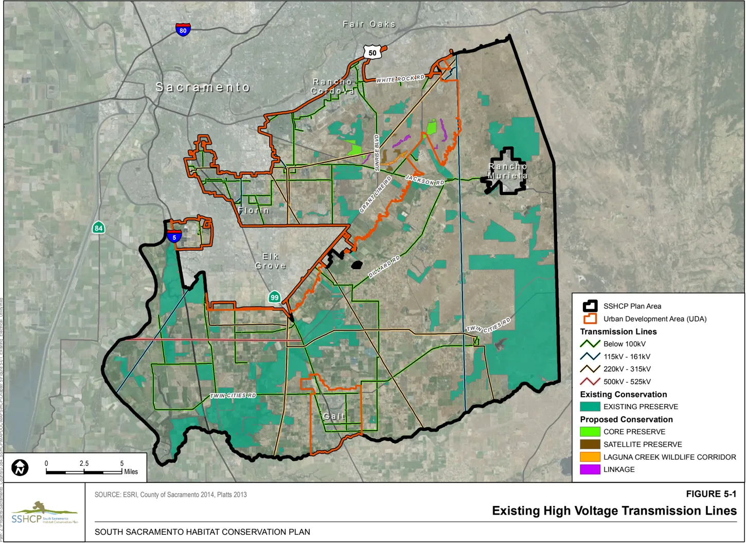
The Plan Permittees estimate that there are approximately 70 miles of existing highvoltage transmission lines (18 miles within the UDA and 52 miles outside the UDA) in areas that are existing Preserves or may become SSHCP Preserves, and approximately 16 miles of existing natural gas pipeline (1 mile within the UDA and 15 miles outside the UDA) in areas that are in existing Preserves or may become SSHCP Preserves. Figure 51 illustrates the alignments of existing high-voltage electrical transmission lines in the Plan Area. The repair and maintenance of utility facilities within planned SSHCP Preserves are Covered Activities, consistent with the utility’s existing ROW easements.
-
Solid Waste Management Facilities. These include the expansion and decommissioning of existing landfills, construction and operation of new transfer stations, and construction and operation of new recycling stations within the UDA. Additionally, long-term operation and maintenance activities include inspection, cleaning, rehabilitation, repair, and/or replacement of these sanitation facilities.
Operation and maintenance of existing groundwater extraction and monitoring wells and associated groundwater treatment facilities at Kiefer Landfill, and construction, operation, and maintenance of new groundwater extraction and monitoring wells at Kiefer Landfill are SSHCP Covered Activities.
-
Wastewater (Sewer) Facilities. Covered Activities related to wastewater facilities include all activities in the UDA that support the provision of wastewater services (e.g., collection, conveyance, diversion, delivery, storage, treatment, transmission, distribution, discharge). Covered Activities include construction, installation, operation, and maintenance of new wastewater facilities, as well as extension, removal, replacement, abandonment, operation, and maintenance of existing wastewater facilities. Wastewater facilities generally include, but are not limited to, pumping stations, booster pumps, wastewater and water treatment facilities (including satellite, scalping, and separation facilities), sewage force mains, gravity sewage pipelines (interceptor, trunk, collector pipelines), pressurized pipelines (water, gas, sludge, chemical), valves, gates, weirs, recharge ponds and spreading basins, small containment berms, groundwater wells, tanks, landscaped areas near facilities, storage facilities, other miscellaneous structures and equipment (power, control, diversion, discharge, junction, metering, telemetry), and access facilities (structures, vaults, maintenance holes, roads). Access structures for gravity pipelines (typically maintenance holes) are necessary for maintenance, inspection, and safety purposes at approximately 1,000-foot intervals for interceptors, approximately 500-foot intervals for trunks, and approximately 400-foot intervals for collectors.
Construction of wastewater facilities generally includes, but is not limited to, vegetation clearing, grading, trenching, excavating soil, trenchless construction (including tunneling support activities), placing backfill material, compacting soil, staging equipment and materials, hauling equipment and material, installing underground sewage pipelines and structures, soil stabilization/improvement activities, drilling/boring activities, pouring concrete, stockpiling materials, installing linings or liner systems, and building aboveand below-grade structures. Underground wastewater facilities typically use open cut construction and installation methods. However, as discussed below, sewage pipelines and force mains may also be installed using trenchless construction methods in areas where open cut construction is not practical (e.g., depth, obstacle, risk). Although trenchless construction methods may be used to avoid impacts to specific areas, they usually require additional temporary construction area (for shafts and at-grade support equipment) and extend for the duration of overall construction project.
Extension of existing sewage pipelines and installation of new sewage pipelines and structures typically require open cut excavation to place the pipelines and structures 10 to 40 feet below ground level. Where construction of a new sewage pipeline or other underground wastewater facility crosses a creek or other body of water, temporary diversion of the stream channel or dewatering aquatic habitats may be required during pipeline or structure construction to lower the groundwater level to at least 2 feet below the installation depth. After construction, the water level of the feature that was dewatered will be monitored to ensure that it returns to its pre-construction level.
All-weather access is typically required to access structures and manholes, which are typically spaced at intervals of approximately 1,000 feet for interceptors, 500 feet for trunks, and 400 feet for collectors. This access requires construction of a gravel access road to all access structures that do not have existing all-weather access roads. Construction of wastewater facilities may also require temporary construction easements with an average width of approximately 120 feet. Temporary staging areas for office trailers associated with construction (contractor’s field office), equipment parking, and material storage are sometimes used and may require up to a 1-acre site adjacent to and/or within proximity to the project. When required, these sites are temporarily disturbed to provide an all-weather surface (top layer of soil sometimes removed and stored, typically with 12 to 18 inches of gravel placed on top of a layer of barrier fabric over the entire site). These sites will be restored to their pre-construction condition (when possible) after construction activities are complete.
Sewage pipelines may also be installed using trenchless construction methods in areas where open cut construction is not practical due to depth, where pipeline obstacles such as a creek or railroad are confronted, or to avoid direct or indirect effects on Covered Species and their habitats. Trenchless construction methods for large pipelines require launching and receiving shafts at each end of the tunneled section, usually several feet deeper than the tunnel invert. These shafts may involve large excavations up to 7,500 square feet to provide space for inserting the tunnel boring machine, trailing gear, and pipe segments; removing excavated tunnel material; and performing other tunneling support activities. Temporary construction staging areas (up to 2 acres) adjacent to and/or close to tunnel shafts are usually required to store tunnel lining material and pipe sections, support dewatering activities, and process tunnel muck. Depth of tunneled unpressurized pipelines is relatively consistent with the connecting open-cut sections (i.e., 10 to 40 feet below ground level), and cannot typically be adjusted to avoid mining through subsurface soil features. After the tunneling activity is completed, grout can be injected around the exterior of the tunnel lining or pipe to prevent water from migrating along the interface between the pipe exterior and the soil.
Covered Activities also include the routine operations and maintenance work that occurs on new and existing wastewater facilities. Operations and maintenance activities typically occur within existing ROWs or easements, and generally include inspection, cleaning, rehabilitation, repair, and/or replacement of aboveground and belowground wastewater facilities. These facilities include, but are not limited to, pumping stations, booster pumps, wastewater and water treatment facilities (including satellite, scalping, and separation facilities), sewage force mains, gravity pipelines (e.g., interceptor, trunk, collector), pressurized pipelines (e.g., water, gas, sludge, chemical), valves, gates, weirs, groundwater recharge and reclamation facilities (including recharge ponds or spreading basins for indirect groundwater recharge purposes), small containment berms, groundwater wells, tanks, landscape areas, storage facilities, other miscellaneous structures and equipment (e.g., power, control, diversion, discharge, junction, metering, telemetry), and access facilities (e.g., structures, vaults, maintenance holes, roads). All associated activities required to complete routine and emergency operations and maintenance work are also included as Covered Activities. Over the 50-year Permit Term, some existing facilities will require replacement and may involve surface and subsurface construction activities, methods, and disturbances equivalent to new construction.
Operation and maintenance of existing wastewater projects required to provide sewer service to existing communities outside the UDA are also Covered Activities. These projects serve areas such as the rural communities of Walnut Grove and Courtland.
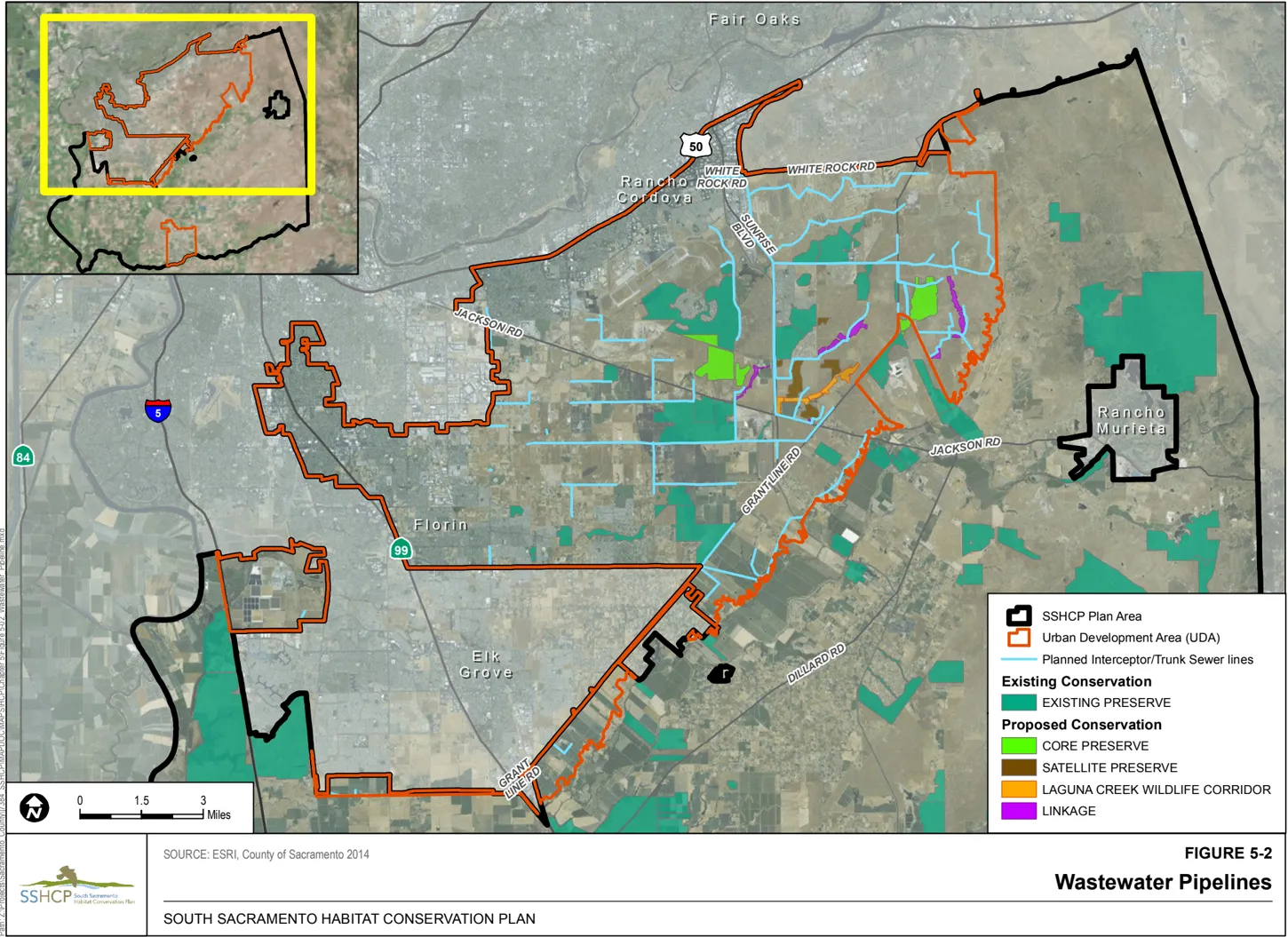
The Plan Permittees have reviewed planning documents prepared by the Sacramento Regional County Sanitation District to identify the proposed locations of future wastewater pipelines. The planned pipeline alignments were relocated, to the maximum extent practicable, so that the pipeline will be built within existing or planned roadways (Figure 52). There remains the possibility that some of the pipeline alignments will need to cross a Preserve where the location of that Preserve cannot be anticipated at this time. The Plan Permittees estimate that up to 1.5 miles of wastewater pipeline may cross existing or planned Preserves. The repair and maintenance of wastewater pipelines within planned and existing Preserves are Covered Activities. If this is necessary, impacts will be avoided or minimized to the maximum extent practicable by Condition 8, as listed in Section 5.4.
The construction, operation, and maintenance of wastewater facilities are Covered Activities. Entities that are not Plan Permittees that propose construction of wastewater projects may be treated by the Implementing Entity as a Participating Special Entity (see Chapter 9, Section 9.3.1).
-
Urban Transportation. Urban Transportation includes construction, realignment, widening, extension, abandonment, and removal of public and private roadways (includes state-owned facilities such as State Route (SR-) 16 and U.S. Route 50), intersections, interchanges, culverts, bridges, light rail lines, railroads, bike and pedestrian paths, sidewalks, street lights, traffic signs, roadside drainages, public and private bus transit lines, and other activities and appurtenances necessary to implement adopted transportation or capital improvement plans of the three Land Use Authority Permittees (the County of Sacramento and Cities of Galt and Rancho Cordova).
Major roadways are proposed in the circulation/transportation elements of each Land Use Authority Permittee’s general plan, and are classified (from larger to smaller) as expressways, thoroughfares, arterials, urban collectors, rural collectors, and streets. Roadway standards vary by jurisdiction and may change during the 50-year Permit Term because circulation elements and general plans are updated over time. Future changes to the circulation element or general plan with regard to specific transportation facilities are Covered Activities under this Plan. Covered Activities include in-stream activities for transportation improvements at stream/creek crossings, including bridges, culverts, or other stream-crossing facility construction, replacement, and repair. During the construction of transportation infrastructure, it may be necessary to temporarily divert stream channels using appropriate measures to avoid or minimize impacts to stream habitat (refer to Condition 7 in Section 5.4).
Urban Development road projects will be designed to avoid and minimize, to the extent feasible, direct and indirect effects to Covered Species, and maintain wildlife movement and dispersal through the SSHCP Preserve System in accordance with the Biological Goals and Measurable Objectives (Table 7-1), and may need to incorporate wildlife crossing structures (see Condition 4 in Section 5.4).
Most roadway projects will be constructed while maintaining existing vehicle access. Travel lanes will be narrowed and traffic will be shifted to one side of the existing roadway to construct improvements on the other side. Drainage facilities such as cross culverts and box culverts will be installed. Roadway and ditch excavation will follow with the removal of native soils to accommodate a new pavement structural section where the roadway is being widened. New roadside drainage ditches will also be excavated at this time. The new roadway section will be built up, usually consisting of aggregate base material and followed with asphalt concrete pavement. Upon completion of the improvements on one side, existing traffic will be shifted over onto the newly constructed roadway section, and a similar construction activity sequence will occur on the other side of the roadway. Improvements at intersections will also occur. If the project includes landscaped medians, installation of irrigation and landscaping components will follow roadway construction, with existing traffic shifted to the outsides of the widened roadway to allow construction access to the center median. These projects will be finished with a final asphalt concrete pavement overlay of the entire roadway section, followed by roadway striping and signing.
All routine road operation and maintenance activities conducted under the jurisdiction of Plan Permittees are Covered Activities. Road maintenance activities generally include, but are not limited to, signage maintenance or replacement; traffic control device maintenance or replacement; guardrail, fence, or crash cushion inspection, maintenance, and replacement; pavement maintenance and resurfacing, including replacing pavement striping or markers; tree trimming and removal; collection and removal of debris from roads, including from road shoulders and trash racks; natural disaster, storm, and vehicle accident damage repair and cleanup; manual, mechanical, and chemical 4 weed control (see ROAD-3); mowing of medians and shoulders; grading shoulders and other areas within the ROW; grading existing dirt roadways; roadside ditch and irrigation ditch sediment removal; repair, replacement, and maintenance of retaining walls, curbs, gutters, sidewalks, culverts, and drop inlet structures; bridge repair and maintenance; ditch, catch basin, and hydrauger clearing; landscaping maintenance; and other routine road operation and maintenance activities.
The Plan Permittees have reviewed planning documents prepared by the Sacramento County Department of Transportation to identify the proposed locations of future roadways. The planned roadways were relocated to the maximum extent practicable so that the roadways will not impact planned Preserves. Potential impacts from all road construction will be avoided or minimized to the maximum extent by Condition 4 as listed in Section 5.4.
The County of Sacramento is a Plan Permittee and is one of the primary agencies responsible for the construction, operation, and maintenance of transportation projects in the Plan Area. However, construction and maintenance of transportation projects by other Plan Permittees are also Covered Activities. The future Implementing Entity and the three Land Use Authority Permittees (the County of Sacramento and the Cities of Galt and Rancho Cordova) may extend incidental take coverage provided by the ITPs to urban transportation Covered Activities proposed by third parties. All Third-Party Project Proponents (e.g., private developers) seeking coverage for urban transportation Covered Activities under the SSHCP permits must obtain approval from the Land Use Authority Permittee with jurisdiction over the activity or project. Entities that are not Plan Permittees that propose construction of transportation projects may be treated by the Implementing Entity as a Participating Special Entity (see Section 9.3.1).
-
Stream Channel Modification. This Covered Activity includes the permanent deepening, widening, or re-routing of existing stream channels during Urban Development. During construction of water supply, wastewater, and urban transportation infrastructure or public and private utilities, it may also be necessary to temporarily divert stream channels, using appropriate measures to avoid or minimize impacts to Stream habitat (refer to Condition 7 in Section 5.4).
5.2.1.1 Capital Southeast Connector
Section titled “5.2.1.1 Capital Southeast Connector”In 2002, the Sacramento Area Council of Governments initiated the Capital Southeast Connector (formerly known as the Elk Grove-Rancho Cordova-El Dorado Connector Project) during preparation of Metropolitan Transportation Plan 2025 (SACOG 2002). The Capital Southeast Connector is a proposed 35-mile-long multi-modal transportation facility spanning from Interstate 5, south of Elk Grove, northeast through the SSHCP UDA, to U.S. Route 50 in El Dorado County (just east of El Dorado Hills, outside the Plan Area). The Capital Southeast Connector will link communities in El Dorado and Sacramento Counties and the Cities of Folsom, Rancho Cordova, and Elk Grove. (Those portions of the Capital Southeast Connector that are in El Dorado County are outside the Plan Area.) Approximately 26.5 linear miles of the proposed Capital Southeast Connector are within the Plan Area, with 17.3 of those miles inside the UDA and 9.2 miles outside the UDA (Figure 5-3). As discussed in Chapter 1, the Capital Southeast Connector Joint Powers Authority is an SSHCP Permittee.
Construction Covered Activities for the Capital Southeast Connector include, but are not limited to, initial vegetation clearing, grading of the project footprint, pouring of concrete or asphalt, excavating, staging of equipment and materials, compacting soil, and landscaping, as well as operation and maintenance. During construction of the Capital Southeast Connector, it may be necessary to temporarily divert stream channels, using appropriate measures to avoid or minimize impacts to Stream habitat (refer to Condition 7 in Section 5.4).
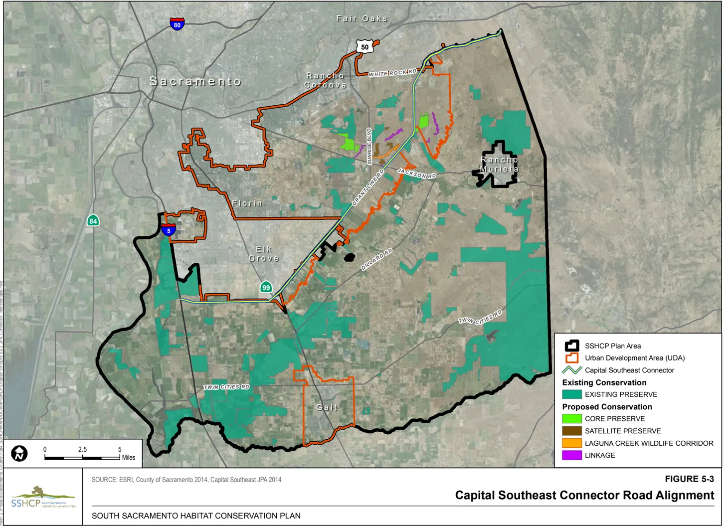
In March 2012, the Board of Directors for the Capital Southeast Connector Joint Powers Authority certified a program-level EIR for the Capital Southeast Connector project under the California Environmental Quality Act (CEQA), and adopted a general alignment for the project (see Figure 5-3). Only the general alignment is described (Chapter 5) and analyzed (Chapter 6) in this SSHCP document. Generally, the Capital Southeast Connector includes the following project segments:
- A four-lane expressway segment from the Interstate 5/Hood-Franklin Road Interchange easterly along an extension of Kammerer Road to the existing Kammerer Road/ Bruceville Road intersection
- A four- to six-lane thoroughfare segment east of the Kammerer Road/Bruceville Road intersection along Kammerer Road, and then northeast on Grant Line Road to its intersection with Bond Road (note: this road segment is within the UDA)
- A four-lane limited access rural thoroughfare along Grant Line Road from the intersection of Bond Road, northeasterly to the intersection of Calvine Road (note: this road segment is within the UDA)
- A four- to six-lane expressway segment on Grant Line Road from its intersection with Calvine Road, northeasterly to the intersection of White Rock Road, and then on White Rock Road from its intersection with Grant Line Road easterly to the Sacramento County/El Dorado County Line
- A four- to six-lane thoroughfare segment on White Rock Road from the Sacramento County/El Dorado County line northeasterly to the intersection with U.S. Highway 50 at a future interchange at Silva Valley Parkway (note: this segment and interchange are outside of the Plan Area, so are not SSHCP Covered Activities or covered by the SSHCP permits)
Future vehicular access to and from the completed Capital Southeast Connector will be minimized and strictly controlled so as to allow through-travel mobility of the Capital Southeast Connector, consistent with the description of the general alignment. Access will be limited to grade-separated interchanges (either undercrossing or overcrossing), signalized intersections, and limited-access intersections. Other existing and future access not intended to have direct access to the Capital Southeast Connector may be consolidated and conveyed to appropriate interchanges, traffic signals, and/or limited-access intersections via a frontage roadway. At-grade signalized intersections and limited-access intersections may be converted to grade-separated interchanges as required by the future travel demand and level of service (LOS) conditions.
Within the expressway segments, the minimum interchange/traffic signal spacing will be 1 mile, with spacing less than 0.50 mile allowed only in unique situations and where an acceptable LOS and design speed can be maintained. Within the thoroughfare segments, the minimum interchange/traffic signal spacing will be 0.50 mile, with 1-mile spacing preferred. Access planning and control must balance the need to maximize the Capital Southeast Connector’s capacity with the need to accommodate local traffic, including that of residents and the need for access to accommodate agricultural and other business activity where appropriate. Vehicle access will be limited in the expressway portions of the Capital Southeast Connector to gradeseparated interchanges (either undercrossing or overcrossing) or to signalized intersections where an acceptable LOS and design speed can be maintained. Existing and future access along the Capital Southeast Connector between grade-separated interchanges and/or at-grade signalized intersections will be consolidated and conveyed to appropriate interchange and/or traffic signals via a frontage roadway. At-grade signalized intersections may be converted to grade-separated interchanges as required by the future travel demand and LOS conditions.
The Capital Southeast Connector will also accommodate bicyclists, pedestrians, and equestrians. In the expressway segments, the Capital Southeast Connector will include a separated, 12-footwide Class I (multiuse) path with graded shoulders. Consideration will be given to providing either an undercrossing or overcrossing of the Class I path at grade-separated interchanges. The Class I path will also include some bicycle/pedestrian overcrossings/undercrossings at key locations between the interchange locations to provide bicycle and pedestrian connectivity to local development. Within the thoroughfare segment, bicyclists and pedestrians will be accommodated on a 10-foot-wide Class I path located on both sides of the Capital Southeast Connector. Bicyclists will also be accommodated with Class II bike lanes on the roadway. Within the four-lane limited access rural thoroughfare along Grant Line Road from the intersection of Bond Road, northeasterly to the intersection of Calvine Road, bicyclists, pedestrians, and equestrians will be accommodated on a 10-foot-wide separated Class I (multiuse) path and a Class III shoulder.
The majority of ground disturbance expected from construction of the Capital Southeast Connector will occur within the UDA. However, ground disturbance will also occur outside the UDA (see Figure 1-1). Activities related to segments of the connector alignment that are within the Plan Area will be SSHCP Covered Activities.
The Capital Southeast Connector is designed to avoid and minimize direct and indirect effects, and maintain existing wildlife movement and Preserve connectivity in accordance with the Biological Goals and Measurable Objectives (Table 7-1), and will incorporate wildlife crossing structures (refer to Condition 4 in Section 5.4).
The entire footprint of the Capital Southeast Connector within the boundaries of Sacramento County is included in the SSHCP Plan Area, and activities related to the connector are SSHCP Covered Activities.
Although the City of Folsom is not a Plan Permittee, the planned improvements to White Rock Road inside the Plan Area and the area needed for the expansion of White Rock Road as part of the Capital Southeast Connector or independently by a Plan Permittee are within the SSHCP Plan Area, and activities related to White Rock Road are SSHCP Covered Activities.
As discussed in Chapter 6, the SSHCP impact analysis assumes that 100 feet from the centerline of existing road segments (200-foot-wide ROW corridor) will be impacted for the Capital Southeast Connector. The methods for construction will be similar to those described under Urban Transportation, above.
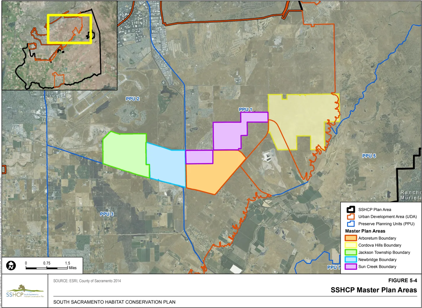
5.2.1.2 Mather Airport Master Plan Development Projects
Section titled “5.2.1.2 Mather Airport Master Plan Development Projects”Mather Airport is located in Preserve Planning Unit (PPU) 2 inside the UDA. Covered Activities related to Mather Airport Master Plan development projects include maintenance of, replacement of, and improvements to existing airfields (e.g., runway extensions, new taxiways and aprons), aircraft storage facilities, aircraft maintenance facilitates, jet fuel storage and dispensary facilities, commercial facilities, and instrument landing systems, 5 and construction of new airfields.
5.2.1.3 Master Plans Known at Time of SSHCP Preparation
Section titled “5.2.1.3 Master Plans Known at Time of SSHCP Preparation”Five large Urban Development Master Plans (Arboretum, Cordova Hills, Jackson Township, NewBridge, and SunCreek) are proposed by Third-Party Project Proponents within the UDA (Figure 5-4). These master plans meet the definition of an Urban Development Covered Activity, and the Plan Permittees anticipate that these master plans or builders purchasing large lots from the master plan developer will use the SSHCP to obtain authorization for species incidental take under the ESA and CESA and to expedite their individual Clean Water Act permitting requirements. These five master plans were designed to comply with SSHCP requirements, including compliance with the Covered Activity descriptions and the SSHCP Avoidance and Minimization Measures (AMMs) listed in this chapter. See Appendix K for additional information on these five master plans and for any SSHCP AMMs that may be specific to these master plans.
5.2.2 Mining in the UDA
Section titled “5.2.2 Mining in the UDA”Mining includes the surface extraction of rock or mineral resources and construction of associated infrastructure, buildings, and facilities. Facilities may include surface mining pits, processing sites, and aggregate transfer systems such as conveyors and access roads and similar facilities. This Covered Activity includes construction and operation of detention basins to capture and reuse water on site.
The Plan Permittees estimate that up to five more surface mines totaling up to 500 acres will occur within the UDA during the 50-year Permit Term. These mines have a typical depth of 30 to 40 feet, but can be deeper depending on the location of the resource. These mines will be operated to extract alluvial sand and gravel deposits. They will be located within PPU 2 and/or PPU 3 (Figure 1-1). Covered Activities include the reclamation of previously mined land in accordance with the federal Surface Mining and Reclamation Act of 1977 and the California Surface Mining and Reclamation Act of 1975. Reclamation may include restoration of original topography, revegetation of mined areas, and other measures as would be included in a reclamation plan approved by the California Geological Survey.
5.2.3 Rural Transportation Projects
Section titled “5.2.3 Rural Transportation Projects”Rural Transportation Projects include transportation projects outside the UDA that are approved pursuant to the circulation element of Sacramento County’s 2030 General Plan. Rural Transportation Projects that are SSHCP Covered Activities are designed to improve traffic circulation for existing communities, roadway alignments, and safety on public roadways. Roadways that are proposed in Sacramento County’s General Plan circulation/transportation element are classified (from larger to smaller) as expressways, thoroughfares, arterials, urban collectors, and rural collectors. In some instances, the SSHCP proposes to shift roadway alignments from what is currently proposed in the General Plan circulation/transportation element to avoid impacts to aquatic resources. These shifts are very minor and do not alter the general alignment of Rural Transportation Projects depicted in the County’s General Plan. The preliminary alignment for each Rural Transportation Project is shown in Figure 5-5.
Construction actions generally include, but are not limited to, initial vegetation clearing, grading, pouring concrete or asphalt, excavation, staging equipment and materials, compacting soil, landscaping, and maintenance. See Section 5.2.1, Urban Development in the UDA, for a more detailed description of roadway construction methods. Rural Transportation Covered Activities include up to 48 relatively small in-stream activities for transportation improvements at stream/creek crossings for bridge, culvert, or other stream crossing facility construction, replacement, and repair (Figure 5-5).
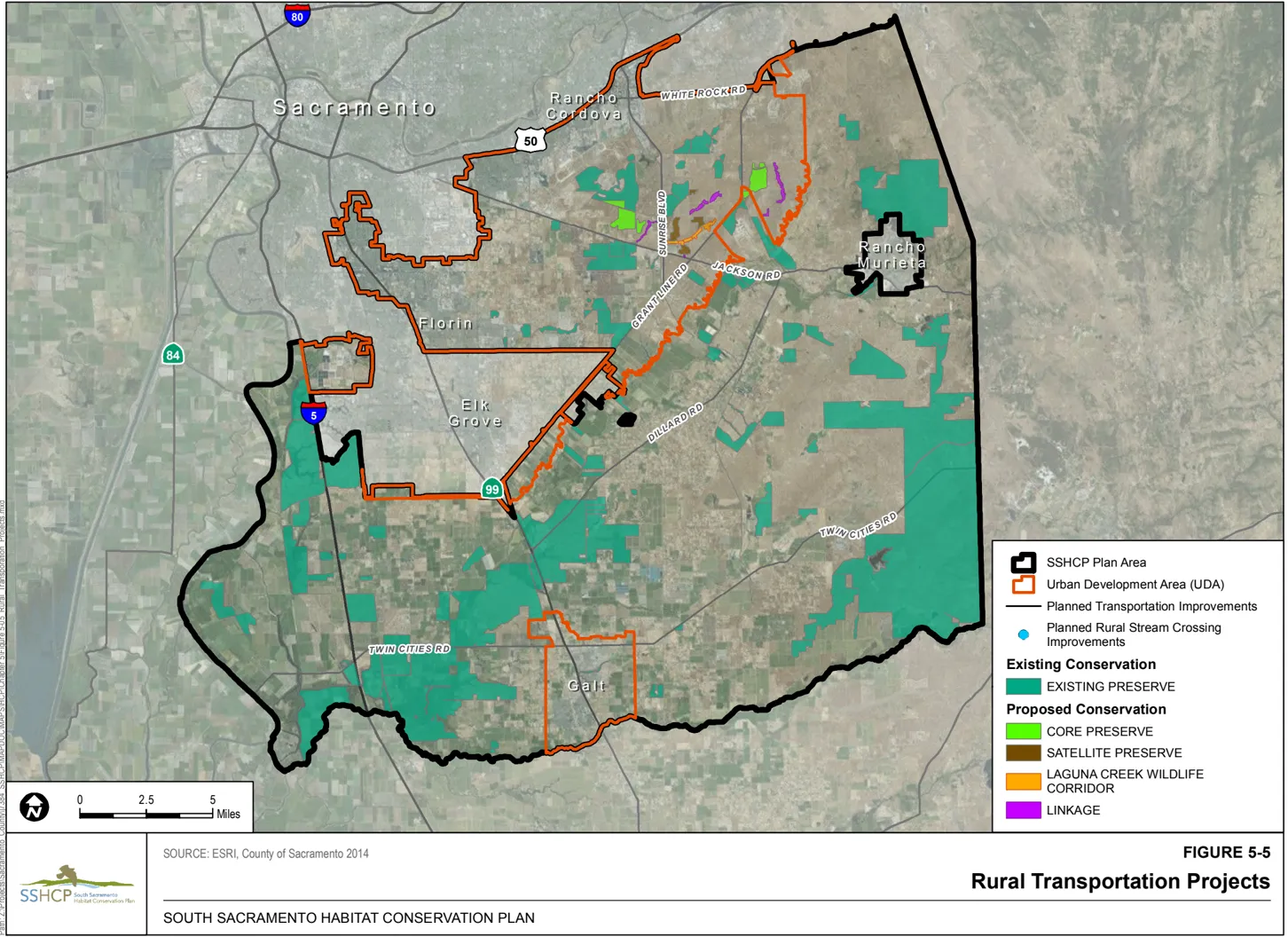
All routine rural road operations and regular maintenance are Covered Activities. Actions generally include, but are not limited to, signage maintenance and replacement; traffic control device maintenance and replacement; guardrail, fence, and crash cushion inspection, maintenance, and replacement; pavement maintenance and resurfacing, including replacing pavement striping and markers; tree trimming and removal; collection and removal of debris from roads and shoulders; natural disaster, storm, and vehicle accident damage repair and cleanup; weed control, mowing medians and shoulders, and grading shoulders and other areas within the ROW; grading existing dirt roadways; roadside ditch and irrigation ditch sediment removal; repair, replacement, and maintenance of retaining walls, curbs, gutters, sidewalks, culverts, and drop inlet structures; bridge repair and maintenance; ditch, catch basin, and hydrauger clearing; landscaping maintenance; and other routine road operation and maintenance activities. The construction of Rural Transportation Projects may temporarily divert stream channels, using appropriate measures to avoid or minimize impacts to Stream habitat (refer to Condition 7 in Section 5.4).
Rural Collector Road Improvements
Section titled “Rural Collector Road Improvements”Rural collectors are two-lane roads in rural areas. Improvements to these roadways include widening the pavement to add or increase the road shoulder and drainage improvements. The following rural collector road projects are Covered Activities that will occur outside the UDA. Estimated lengths of the road projects located outside the UDA are rounded to the nearest 0.5 mile.
- Scott Road between White Rock Road and Latrobe Road (8 miles)
- Latrobe Road between Scott Road and Stonehouse Road (less than 0.15 mile)
- Stonehouse Road between Latrobe Road and Jackson Highway (1.5 miles)
- Ione Road between Jackson Highway and the Sacramento County line (6 miles)
- Select stream crossings along Clay Station Road between Dillard Road and the Sacramento County line (less than 0.3 mile)
- Borden Road between Twin Cities Road and Clay Station Road (4.5 miles)
- Bruceville Road between Twin Cities Road and Kammerer Road (5.5 miles)
- Twin Cities Road between Interstate 5 and River Road (12.5 miles)
Arterial Road Improvements
Section titled “Arterial Road Improvements”Arterials provide a link between thoroughfares and collectors. Arterials are typically developed as four-lane roadways with a center two-way left-turn lane or a raised center median with adjacent Class I, Class II, or Class III bikeway facilities. The following arterial road widening projects are Covered Activities that will occur outside the UDA:
- Dillard Road between SR-99 and Jackson Highway (14.5 miles)
- Alta Mesa Road between Twin Cities Road and Dillard Road (8.5 miles)
- Valensin Road between Arno Road and Colony Road (3.5 miles)
- Arno/Riley Road between SR-99 and Valensin Road (3.3 miles)
- Franklin Boulevard between Kammerer Road and Twin Cities Road (6 miles)
- Twin Cities Road between SR-99 and Interstate 5 (8 miles)
- Green Road between Dillard Road and Wilton Road (2.5 miles)
- Wilton Road between Dillard Road and Grant Line Road (3 miles)
- Jackson Highway between Grant Line Road and Stonehouse Road (5.5 miles)
Road Realignment Projects
Section titled “Road Realignment Projects”Road realignment projects entail rerouting existing roadways, generally to facilitate more direct or new road connections. Direct impacts associated with these projects will encompass the entire construction ROW on land that did not previously include a roadway. The following road construction project is a Covered Activity that will occur outside the UDA:
- Valensin Road will be extended 1 mile east from Colony Road to Alta Mesa Road.
Road Interchange Projects
Section titled “Road Interchange Projects”The Sacramento County 2030 General Plan (SACOG 2011) indicates that four interchange projects are planned outside the UDA, located in PPU 6 and PPU 7. Capital Southeast Connector interchanges are also covered by the SSHCP, as discussed in Section 5.2.1.1.
Construction actions generally include, but are not limited to, initial vegetation clearing, grading, pouring concrete or asphalt, excavation, staging equipment and materials, compacting soil, landscaping, and maintenance. The following road interchange projects are Covered Activities:
- Modification of the interchange at Hood Franklin Road and Interstate 5 in coordination with expansion of the Capital Southeast Connector to a four-lane thoroughfare.
- Modification of the interchange at Twin Cities Road and Interstate 5 in coordination with expansion of Twin Cities Road to a four-lane arterial.
- Modification of the interchange at Arno Road and SR-99 in coordination with expansion of Arno Road to a four-lane arterial.
- Modification of the interchange at Dillard Road and SR-99 in coordination with expansion of Dillard Road to a four-lane arterial.
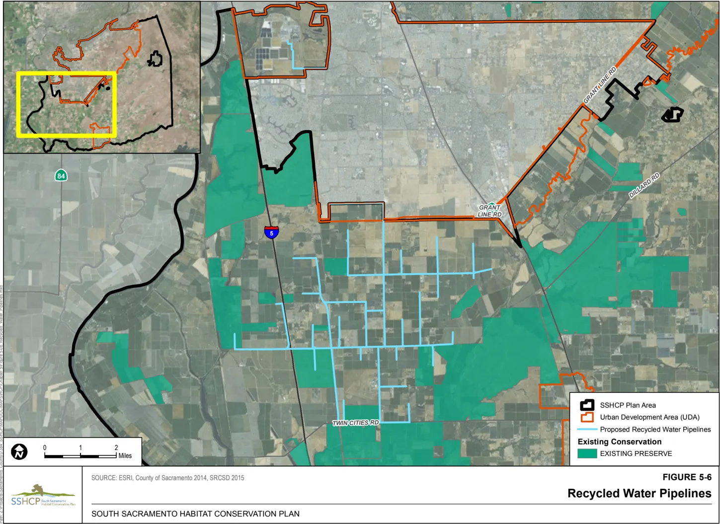
5.2.4 Recycled Water Projects
Section titled “5.2.4 Recycled Water Projects”The SSHCP permits cover two Recycled Water Projects. The first is a small section of pipeline that will provide recycled water to the existing Bartley-Cavanaugh Golf Course, as described in the Sacramento Regional County Sanitation District/Special Plan Area/City of Sacramento Recycled Water Feasibility Study (SRCSD 2015a). The alignment of the first Recycled Water Project follows Freeport Boulevard south where it intersects the UDA for approximately 0.2 mile before turning east for an additional 0.4 mile, until it reenters the UDA (see Figure 5-6).
The second Covered Activity Recycled Water Project is the South Sacramento County Agriculture and Habitat Lands Recycled Water Project (South County Agricultural Program), which was initially identified in the Sacramento Regional County Sanitation District Water Recycling Opportunities Study (SRCSD 2007). In 2011, the Sacramento Regional County Sanitation District initiated the process to develop a more detailed feasibility study for the South County Agricultural Program (SRCSD 2015b). Through this updated feasibility study, the South County Agricultural Program expanded the potential uses of recycled water and the acreage of irrigated areas. The South County Agricultural Program will provide recycled water service from the existing Sacramento Regional Wastewater Treatment Plant to agriculture and habitat lands in the southwest portion of the Plan Area. Recycled water will be used to irrigate agricultural lands and improve aquatic and terrestrial habitat on existing and future conservation lands near the existing Cosumnes River Preserve. Recycled water may also be used to irrigate reestablished/established wetlands and groundwater recharge basins.
A portion of the facilities (i.e., pumping and water transmission pipelines) associated with the South County Agricultural Program will be located within the UDA (approximately 4.3 linear miles), and the South County Agricultural Program will also include open cut trenching for approximately 41.1 linear miles of water distribution pipelines outside the UDA. The proposed transmission pipeline will leave the UDA at the intersection of Kammerer Road and Franklin Boulevard and continue south following the Franklin Boulevard corridor toward its terminus at Twin Cities Road (Figure 5-6). The pipeline footprint will generally follow existing roadways; however, pipelines will cross agricultural lands, including existing and planned Agricultural Preserves. The construction footprint of the water transmission pipeline is anticipated to require a 75-foot-wide ROW for the length of the pipeline, which may overlap the existing and/or future Franklin Boulevard ROW. In addition, approximately one recharge pond totaling approximately 560 acres will be constructed to operate the recycled water system.
Construction and maintenance of facilities associated with the Recycled Water Projects are Covered Activities. Activities generally include, but are not limited to, inspection, cleaning, rehabilitation, repair, and/or replacement of aboveground and belowground recycled water facilities. These facilities include, but are not limited to, recycled water pipelines, pumping stations, underground pressurized pipelines (e.g., water, recycled water, chemical), valves, gates, weirs, other groundwater recharge and reclamation facilities (including recharge ponds or spreading basins for indirect groundwater recharge purposes), other miscellaneous structures and equipment (e.g., power, control, diversion, discharge, junction, metering, telemetry), and access facilities (e.g., structures, vaults, maintenance holes, roads). All associated activities required to complete routine and emergency operations and maintenance work, such as traffic control, are also Covered Activities. Maintenance activities for recycled water facilities are Covered Activities and could include periodic vehicle trips to areas along pipeline corridors. [^6] However, construction of new water diversions associated with Recycled Water Projects is not a Covered Activity and would require separate ESA consultation and permitting (see Section 5.3).
[^6] Access roads will be limited to the pipeline right-of-way.
5.2.5 Covered Activities in Preserve Setbacks in the UDA
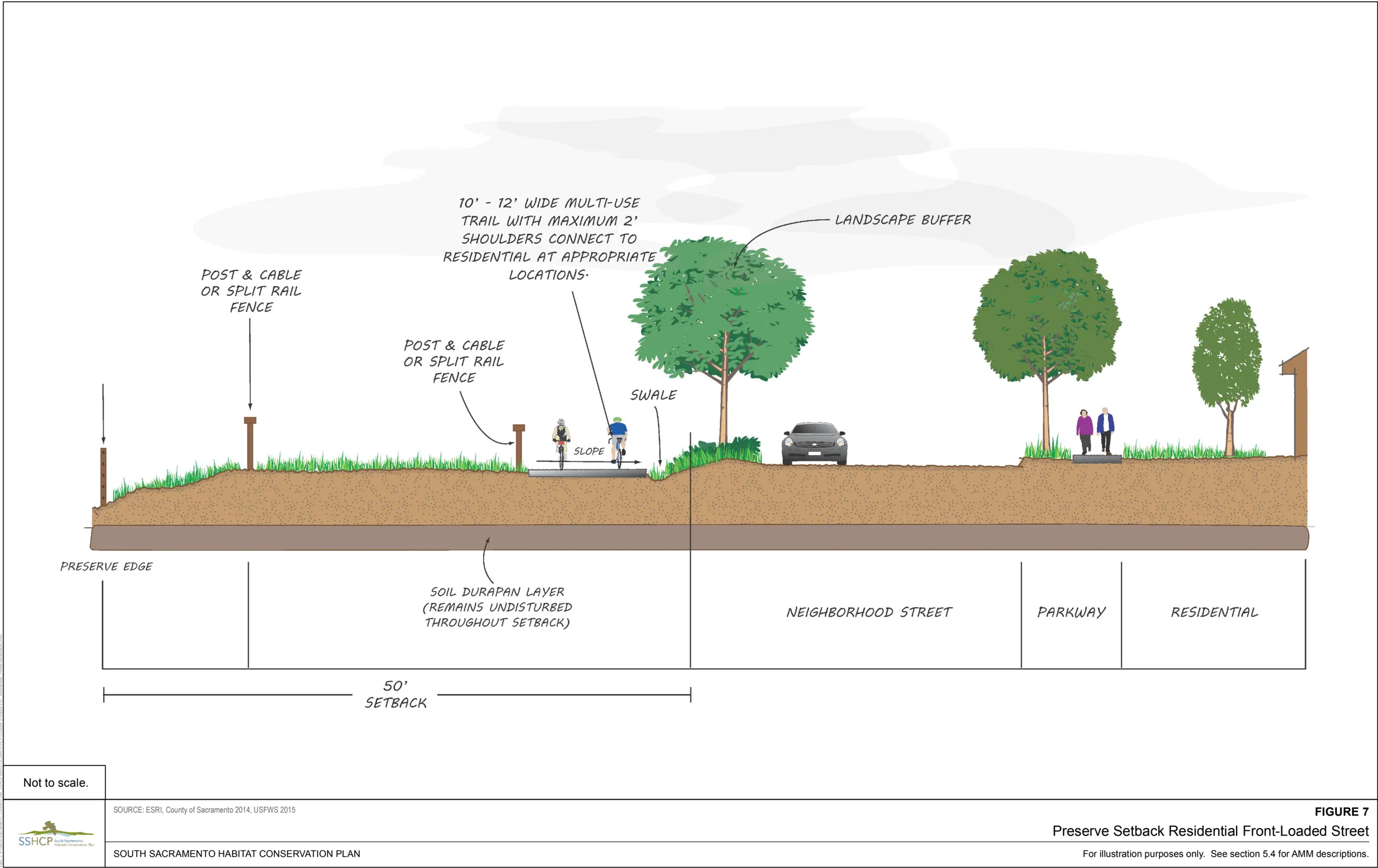
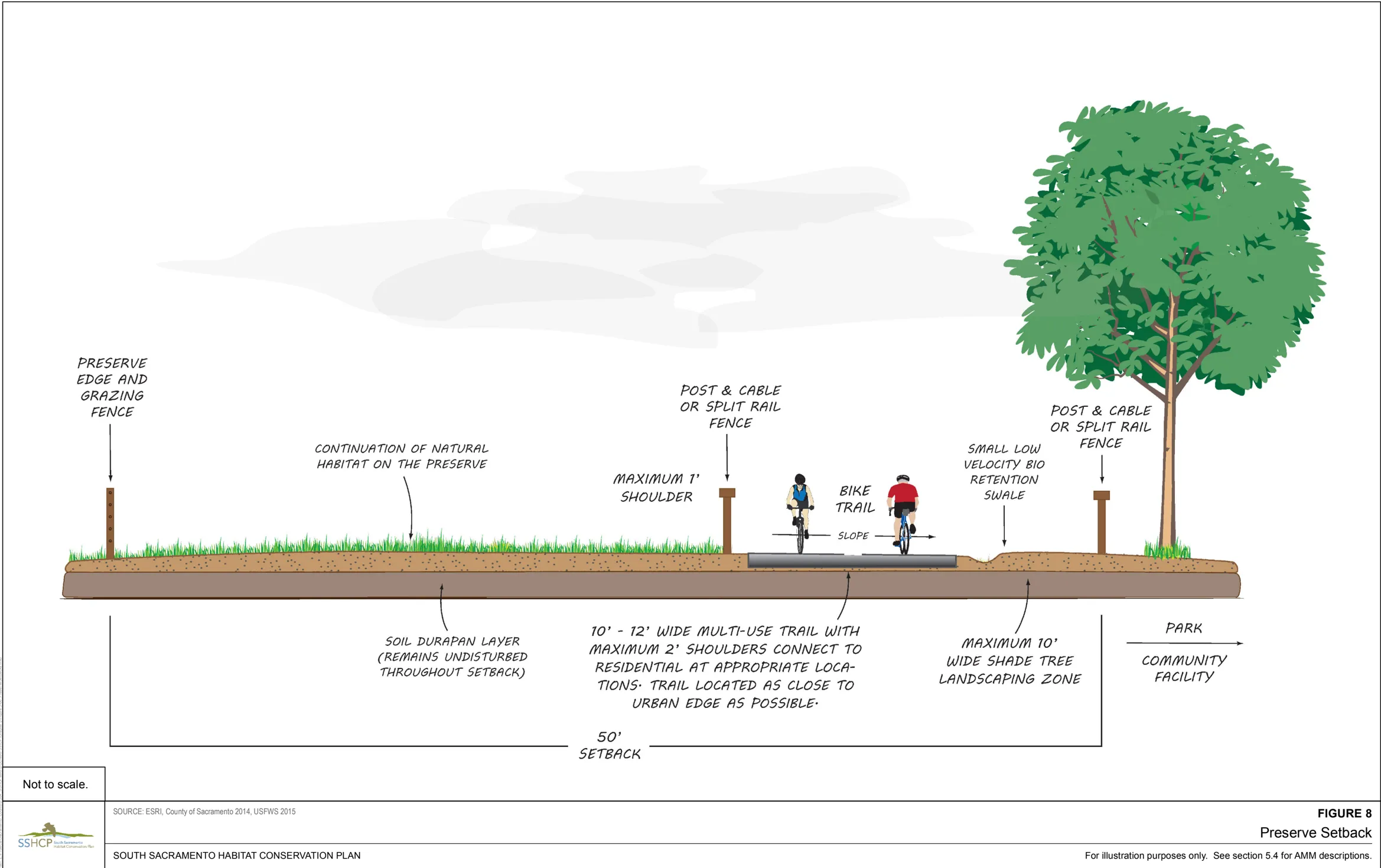
Section titled “5.2.5 Covered Activities in Preserve Setbacks in the UDA”As discussed in Section 5.4, Conditions on Covered Activities, the AMM EDGE-3 requires that a setback of at least 50 feet be established outward from the boundary of any existing or planned Preserve within the UDA to reduce direct and indirect impacts that may result from adjacent Urban Development Covered Activities. The Plan Permittees estimate that approximately 625 acres of Preserve Setback along 105 linear miles will be established within the UDA, based on the perimeters of existing and planned Preserves. The minimum 50-foot-wide setback will remain in its natural state and function as a transition area between urban development and the Preserves. However, specific Covered Activities that entail minimum ground disturbance will be allowed to occur within an SSHCP Preserve Setback, as specified below. Although effects from the construction, use, and maintenance of Covered Activities inside the Preserve Setbacks are expected to be small, some permanent loss of habitat and take of individuals is expected. Figures 5-7 through 5-9 illustrate different applications of the Preserve Setback allowed under the SSHCP, and show minimum requirements of each application.
Where an existing or planned Preserve is adjacent to an existing roadway (e.g., rural collectors, arterials, thoroughfares), the 50-foot Preserve Setback will not be required. In addition, where a planned roadway crosses a planned or existing Preserve, no Preserve Setback will be required. In these two instances, any bicycle or pedestrian trail will be established in the road ROW. Many ground-disturbing Covered Activities will occur within a road or pipeline ROW (e.g., roads, sewer and water supply pipelines, and other underground utilities). Where planned Preserves, Preserve Setbacks, or Stream Setbacks are located adjacent to a ROW, Covered Activities necessary for construction, such as grading and equipment storage, will be allowed within the entire width of the ROW. Ground disturbance will be allowed up to the boundary of the Preserve or Preserve Setback, but not within the Preserve or Preserve Setback. All BMPs and other applicable SSHCP AMMs for the Covered Activity will be implemented.
Several entities may own or be responsible for land within Preserve Setbacks, including, but not limited to, Land Use Authority Permittees, parks and recreation districts, and community service districts. The entity that owns the property within a Preserve Setback will be responsible for managing and maintaining the habitat and developed features (e.g., firebreaks, trails, and bioswales) in the setback in accordance with this section and the conditions in Section 5.4. An easement will be granted to the Implementing Entity that gives the Implementing Entity the ability to enforce the conditions of the easement in perpetuity (see sample easements in Appendix D).
The primary vehicle for public interaction with the SSHCP Preserve System is the incorporation of optional trails within Preserve Setbacks (see Figures 5-7 through 5-9) potentially located around the perimeter of Preserves within the UDA. The public will be able to view and enjoy the Preserve System from trails in the Preserve Setbacks.
As discussed in Chapter 7, the main purpose of the SSHCP Preserve System is to preserve and enhance Plan Area biological resources to achieve the Biological Goals and Measurable Objectives of the SSHCP. The UDA’s Preserve Setback trail system and environmental educational opportunities on certain UDA Preserves will provide indirect benefits to the SSHCP Covered Species through the following:
- Fostering public awareness and public support for the SSHCP Preserve System.
- Providing a general appreciation of Sacramento’s natural history.
- Providing opportunities to view vernal pools (from the trail), birds, and other wildlife, and for recreation.
Covered Activities within an SSHCP Preserve Setback include the following, as allowed under each Preserve Setback easement:
-
Trails. Construction and maintenance of permeable or semi-permeable hiking trails and paved community trails are Covered Activities in the UDA for Preserve Setbacks,provided that they conform to AMM EDGE-3 described in Condition 2 (also see Figures 5-7 through 5-9). Use by pedestrians, bicycles, and domestic animals (including horses and leashed dogs) is a Covered Activity for trails within SSHCP Preserve Setbacks. The maximum trail width will be 16 feet, including 2-foot-wide shoulders. The Plan Permittees request that the SSHCP permits cover construction, operation, and maintenance of up to 105 linear miles of trails to be constructed within Preserve Setbacks located in the UDA.
-
Low-velocity bio-retention swales. These swales will be designed to hold rainwater runoff from trails and prevent runoff entry into Preserves. These are typically small linear features that will be placed on one or both sides of trails within the setback (see Figures 5-7 through 5-9). Construction, operation, and maintenance of these swales are SSHCP Covered Activities and are covered by the SSHCP permits. Construction practices that cut into or disrupt the soil’s hardpan or duripan will not be used to construct swales within setbacks (see EDGE-7). Any fill soil imported to construct the swale will be free of invasive species.
-
Fencing. Post and cable, split rail, or other open fencing will be installed adjacent to Preserve Setback trails and are intended to keep pedestrians on the trail. Additional fencing at the Preserve boundary will also be necessary to keep livestock in the Preserve and out of the setback (see Figures 5-7 through 5-9 ) . The type of fencing required for livestock will be specified in the Preserve Management Plan (see Chapter 8, SSHCP Monitoring and Management Programs).
-
Firebreaks. A firebreak is a gap in combustible material (vegetation) that acts to slow or stop the spread of a wildfire. Firebreaks will be allowed inside Preserve Setbacks when necessary. To maintain functionality of the soil perched aquifer, firebreaks allowed inside the setbacks must be created by methods that will not disturb the soil duripan layer, such as mowing, shallow tilling, and minor scraping of surface vegetation. If approved by the local authorities, the setback trail may also be used as a firebreak. The width of firebreaks must comply with applicable local codes.
-
Benches, shade structures, shade trees, and trash receptacles. Benches, shade structures, shade trees, and trash receptacles will be allowed along trails in Preserve Setbacks. Shade trees, benches, shade structures, and trash receptacles must be located on the outer edge of the trail farthest from the Preserve. Shade tree species must be native trees that are found in California grasslands and that can survive on the Vernal Pool/Grassland border without long-term irrigation or fertilization (i.e., valley oak, black oak, blue oak, oracle oak). Irrigation will be allowed for a maximum of 5 years to establish saplings. The Implementing Entity has the discretion to allow irrigation to continue past 5 years if extenuating circumstances necessitate it (e.g., during a drought) and the continuance of irrigation does not affect the Preserve. Plantings in Preserve Setbacks will not include invasive plant species listed on the California Invasive Plant Council’s (Cal-IPC) California Invasive Plant Inventory Database or listed on the CalIPC California Invasive Plant Watch List. 6
-
Interpretive signs and kiosks. Signs and kiosks are intended to educate trail users about the benefits of the SSHCP Preserve System and the importance of the environmental resources that the Preserves are protecting. Safety and directional signs may also be installed. The construction, operation, and maintenance of these signs and kiosks are SSHCP Covered Activities covered by the SSHCP permits.
-
Outdoor Lighting. Outdoor lighting in Preserve Setbacks may be allowed where a Land Use Authority Permittee determines lighting is necessary for public safety or security. Minimization measures may include light fixture placement (e.g., as low to the ground as possible), lamp designs (e.g., shielding, low glare, or no lighting), directing light away from Preserves, or other means to avoid or minimize light pollution.
-
Livestock Access to Preserves. Access points and facilities for delivery and collection of grazing animals (livestock) will be permitted in Preserve Setbacks. The type of fencing required for livestock will be specified in the Preserve Management Plan (see Chapter 8, SSHCP Monitoring and Management Programs).
The Plan Permittees have not identified nonconforming uses or structures within setbacks of planned Preserves. If any nonconforming uses or structures in Preserve Setbacks are identified during SSHCP implementation, the Implementing Entity will coordinate with the Plan Permittee and the Wildlife Agencies to appropriately address the nonconforming use or structure.
5.2.6 Covered Activities in Stream Setbacks in the UDA
Section titled “5.2.6 Covered Activities in Stream Setbacks in the UDA”Stream Setbacks are an increasingly common tool employed to address disturbances to and management of streams and riparian zones and to reduce degradation of water quality. Research studying the effective widths of Stream Setbacks has appeared in the scientific literature since the mid-1960s (Robins 2002). Over the past 40 years, Stream Setbacks have become increasingly recognized for their benefit in controlling non-point- and point-source pollutants (Robins 2002; Semlitsch and Bodie 2003; Wenger 1999). 7
Urbanization adjacent to streams can adversely impact hydrologic functions and water quality. Potential impacts on streams from adjacent Covered Activities may include the following:
- Increased erosion and decreased transmittance of light through the water column due to sediment runoff into streams.
- Excessive nutrient loading into streams or water bodies that could raise nutrient concentrations above safe drinking water levels and cause eutrophication (depletion of oxygen in water).
- Introduction of fecal coliform into streams that contributes to nutrient loading and can introduce pathogenic organisms.
- Introduction of chemicals, pesticides, 7 and heavy metals into streams that may result in mortality of aquatic species.
- Modification of stream water temperature and stream microclimate that may damage the aquatic ecosystem.
- Modification of stream channel complexity that may reduce bank stabilization and increase erosion.
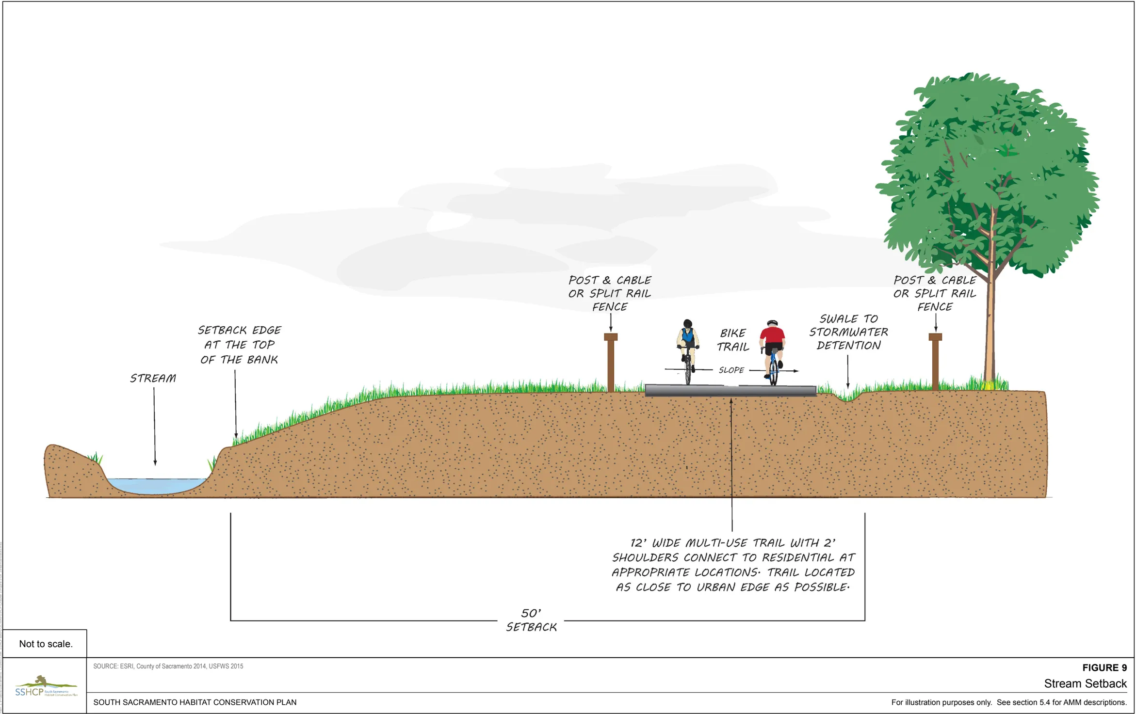
Condition 7 (Section 5.4.1) will be applied to all UDA Covered Activities to avoid or minimize potential indirect and direct impacts to streams and creeks by establishing minimum 100-footwide Stream Setbacks measured from the top of the bank on both sides of the following streams within the UDA: Elder Creek, Frye Creek, Gerber Creek, Morrison Creek, Paseo Central, and Sun Creek (also see discussion of the Laguna Creek Wildlife Corridor in Section 5.2.8).
The primary purpose of a Stream Setback is to minimize indirect effects of adjacent Urban Development Covered Activities on Plan Area waterway hydrologic functions, including water quality, and to avoid or reduce other undesired disturbances to sensitive resources. However, the SSHCP Conservation Strategy (Chapter 7) does not count the avoided area within the Stream Setbacks to be mitigation for Covered Activity impacts on species. In addition, stream segments within an SSHCP Preserve do not require setbacks because the Preserve lands surrounding the stream segment will function to protect the stream. Under certain circumstances, the Stream Setback requirement can be waived for property owners of very small lots, as discussed in Section 9.5.2.
Several entities may own or be responsible for land within Stream Setbacks, including, but not limited to, Land Use Authority Permittees, parks and recreation districts, and community service districts. The entity that owns the property within a Stream Setbacks will be responsible for managing and maintaining the habitat and any constructed features (e.g., trails, bioswales) in the setback. An easement must be granted to the Implementing Entity that gives the Implementing Entity the ability to enforce the conditions of the easement in perpetuity (see sample easements in Appendix D).
Limited Covered Activities are allowed within Stream Setbacks. This section lists the allowed activities within Stream Setbacks. However, where the listed allowable Covered Activities conflict with other laws, regulations, and policies regarding streams, erodible soils, wetlands, floodplains, land disturbance activities, or other environmental protective measures, the more restrictive allowable use will apply. The listed allowable Covered Activities are not intended to supersede any previously issued active permits by Permitting Agencies. Where a permit has been issued, the existing permit conditions (including the terms and conditions of recorded conservation easements required as a permit condition) will supersede the allowable SSHCP Covered Activities. The following are allowed Covered Activities within SSHCP Stream Setbacks:
- Trails. Construction and maintenance of permeable or semi-permeable hiking trails and paved community trails are Covered Activities in the UDA for Stream Setbacks. Use by pedestrians, bicycles, and domestic animals (including horses and leashed dogs) is a Covered Activity for trails within SSHCP Stream Setbacks. The maximum trail width will be 16 feet, including 2-foot-wide shoulders. The Plan Permittees estimate that approximately 150 linear miles of trails will be built within Stream Setbacks located in the UDA.
- Low-velocity bio-retention swales. These swales will be designed to hold and remove runoff from trails and prevent runoff entry into Preserves. These will typically be small linear features that will be placed on one or both sides of trails within the setback or roadways adjacent to the setback (see Figures 5-7 through 5-9). Construction, operation, and maintenance of these swales are SSHCP Covered Activities, covered by the SSHCP permits. Any fill soil imported to construct the swale will be free of invasive species.
- Crossings perpendicular to the stream. Covered Activity crossings of new roads, bike or pedestrian trails, railroads, sewer lines, water lines, recycled water lines, or utility lines are allowed in SSHCP Stream Setbacks as long as they cross perpendicular to the stream. The Land Use Authority Permittees (County of Sacramento and Cities of Galt and Rancho Cordova) will ensure that Third-Party Project Proponents implementing the crossing correctly implement all applicable conditions and AMMs for the aquatic land cover types (see Section 5.4). The Land Use Authority Permittees will also review and approve crossing designs to ensure that the area of the crossing is stabilized (e.g., appropriate bio-engineering solutions) to prevent potential erosion due to its use as a crossing.
- Stream bank stabilization projects. As discussed in Section 5.2.1, stream bank stabilization projects include installation of in-stream structures for erosion control (e.g., appropriate bio-engineering methods). Plan Permittees will review and approve stabilization designs to ensure that they will avoid and minimize impacts to the aquatic land cover types.
- Fencing. Post and cable fencing, split rail, or other open fencing will be installed adjacent to trails and are intended to keep pedestrians on the trail.
- Benches, shade structures, and shade trees. Benches, shade structures, and trash receptacles will be allowed along trails in the SSHCP Stream Setbacks. Shade trees will be allowed at bench sites. Shade trees, benches, shade structures, and trash receptacles must be located on the outer edge of the trail farthest from the creek. Shade tree species must be native trees that are found in SSHCP Riparian land cover types (see Chapter 3) and that can survive in the planted location without long-term irrigation or fertilization. Irrigation will be allowed for a maximum of 5 years to establish saplings. The Implementing Entity has the discretion to allow irrigation to continue past 5 years if extenuating circumstances necessitate it (e.g., during a drought) and the continuance of irrigation does not affect the waterway. Invasive plant species listed on Cal-IPC’s California Invasive Plant Inventory Database or listed on Cal-IPC’s California Invasive Plant Watch List (see http://www.cal-ipc.org/paf/) will not be planted in Stream Setbacks.
- Interpretive signs and kiosks. Signs and kiosks are intended to educate trail users about the benefits of the SSHCP Preserve System and the importance of the environmental resources that the Preserves are protecting. Safety and directional signs may also be installed. The construction, operation, and maintenance of these signs and kiosks are SSHCP Covered Activities covered by the SSHCP permits.
- Riparian habitat re-establishment or establishment. Re-establishment or establishment 8 of riparian vegetation in Stream Setbacks may be desirable to minimize indirect effects of adjacent development or to enhance stream water quality. As discussed in Chapter 9, vegetation re-establishment or establishment plans must be reviewed and approved by the Implementing Entity and Permitting Agencies prior to implementation.
- Outfalls. Construction and operation of outfall structures that allow the discharge of stormwater into a stream from adjacent urban development areas are allowed in SSHCP Stream Setbacks. The Land Use Authority Permittees will review and approve outfall designs to ensure that they correctly apply all applicable design and construction AMMs (refer to Section 5.4).
- Flood control structures and stormwater management. As discussed in Section 5.2.1, flood control and stormwater structures include, but are not limited to, detention basins, bio-retention swales, and water quality facilities that are designed to be compatible with the habitat and wildlife values of the adjacent stream corridor. Land Use Authority Permittees will review and approve designs to ensure that they include all appropriate SSHCP design and construction AMMs (refer to Section 5.4).
Nonconforming 9 Structures and Uses
Section titled “Nonconforming 9 Structures and Uses”Existing nonconforming structures and nonconforming uses of land may be located within SSHCP Stream Setbacks. Existing nonconforming structures or uses are not Covered Activities, but are allowable activities within Stream Setbacks and are subject to the following requirements:
- Legally existing but nonconforming structures or uses may be continued.
- Existing impervious surfaces within the setbacks that resulted from previous allowable disturbances or developments will not be expanded.
- If a legally existing but nonconforming use has been discontinued for more than 90 days, re-establishment will be prohibited by the appropriate Land Use Authority Permittee, with the exception of agricultural uses that are following prescribed BMPs for crop rotation. However, resumption of agricultural uses must be strictly confined to the extent of disturbance existing at the time of adoption of the SSHCP.
Septic Systems
Section titled “Septic Systems”Subsurface sewage disposal systems that currently exist within an area that will become an SSHCP Stream Setback are not Covered Activities but will be ‘grandfathered’ and allowed to remain in the SSHCP Stream Setback. Parcels entitled to install subsurface sewage disposal systems before or at the time of SSHCP permit issuance will also be allowed to install such systems within a Stream Setback, but the operation, maintenance, or replacement of entitled or currently existing subsurface sewage disposal systems are not Covered Activities.
5.2.7 SSHCP Preserve System Covered Activities
Section titled “5.2.7 SSHCP Preserve System Covered Activities”In addition to the activities and actions described above, the SSHCP permits will provide take authorization for activities and actions associated with implementation of the SSHCP Conservation Strategy described in detail in Chapter 7. Most of these activities and actions will take place within the SSHCP Preserve System assembled by the Plan. See Section 5.2.8 for Covered Activities allowed in the Laguna Creek Wildlife Corridor area of the Preserve System. All SSHCP Conservation Actions will take place within the SSHCP Plan Area (see Chapter 7 for a description of all SSHCP Conservation Actions).
As described in Chapter 7, the SSHCP Preserve System will benefit and protect Covered Species within the Plan Area and achieve the SSHCP’s Biological Goals and Measurable Objectives. However, future land management, monitoring, habitat enhancement, habitat reestablishment, and maintenance activities on SSHCP Preserves have some potential to result in adverse effects to Covered Species habitats and individuals. For that reason, Conservation Actions are also SSHCP Covered Activities and are covered by the SSHCP permits. As discussed in detail below, this Preserve System Covered Activity category includes all Plan Permittee actions that might be necessary to achieve the SSHCP Conservation Strategy, including the SSHCP Biological Goals and Measurable Objectives (see Chapter 7). Most of the Conservation Strategy Covered Activities will occur within the SSHCP Preserve System or on lands planned for inclusion in the Preserve System (see Chapter 7 for a description of all SSHCP Conservation Actions). The SSHCP Implementing Entity will oversee implementation of Preserve System Covered Activities, including management and monitoring of the SSHCP Preserve System.
Preserve Management and Monitoring
Section titled “Preserve Management and Monitoring”This category includes all Preserve System land management actions required by the Plan or other actions that might be necessary to achieve the SSHCP Biological Goals and Measurable Objectives (Chapter 7). Activities associated with management of the SSHCP Preserves have the potential to affect Covered Species. This category also includes construction, maintenance, and use of facilities needed to manage the SSHCP Preserve System, including, but not limited to, roads, bridges, culverts, fences, gates, wells, stock tanks, stock ponds, and livestock handling facilities (e.g., corrals, pens, and chutes). As much as possible, Preserve management structures (e.g., Preserve field offices, maintenance sheds, carports) will be located outside Preserve boundaries. Those accessing Preserves for management and monitoring will likely use all-terrain vehicles to the extent feasible, which do not require improved roads. However, access to some infrastructure may require establishment of new dirt roads. Roads, structures, and facilities existing at the time of land acquisition will be used whenever feasible to minimize impacts to species habitats in the Preserve. Where Preserve management structures or access roads must be constructed on Preserve lands, they must be identified in an approved Preserve Resources Management Plan (see Chapter 8) and will be sited to minimize direct and indirect impacts to Covered Species habitat.
Management and monitoring actions that will be used within the SSHCP Preserve System are described in detail in Chapter 8, SSHCP Monitoring and Management Programs. Preserve management activities and facility Covered Activities may include, but are not limited to, the following:
- Demolition or removal of structures, roads, or built livestock ponds to enhance or reestablish habitat.
- Hazardous materials remediation, such as appropriate closure of underground storage tanks, soil remediation, and cleanup of illegal dumping.
- Preserve vegetation management, including grazing of livestock, mowing, manual labor, and prescribed burns. See additional information under ‘Pesticide Use for Land Management,’ below. 10
- Fire management, including prescribed burning and mowing.
- Fuel break establishment on Preserves outside the UDA.
- Vehicle and pedestrian travel, including by all-terrain vehicles or trucks, for inspecting or maintaining facilities, moving, or managing livestock and patrolling.
- Use of mechanized equipment for construction, maintenance, and resource management projects in the Preserve System (e.g., vehicles, weed trimmers, mowers).
- Restoration of historical hydrologic conditions through creation of berms, creation of channels and ditches, filling or plugging of channels and ditches, creation of swales, and demolition or removal of preexisting structures or roads.
- Installation and repair of fencing.
- Construction, rehabilitation, and maintenance of facilities (e.g., pens, corrals, gates, feed storage, wells, water delivery, and water storage) to support livestock grazing as a Covered Species management tool. See additional information under ‘Water Supply for Livestock,’ below.
- Construction, operation, and maintenance of recycled water pipelines providing irrigation to Cropland and Irrigated Pasture Preserves.
- Construction, operation, and maintenance of small solar photovoltaic panels to provide electricity for Preserve management.
- Actions to control non-native species (e.g., feral cats and dogs, red fox, non-native fish, bullfrogs).
- Actions to enhance or re-establish species habitat. See additional information under ‘Habitat Enhancement, Re-Establishment, and Establishment,’ below.
- Certain agricultural activities, such as tilling fields, harvesting crops, and grazing, when they are consistent with provisions of an SSHCP Conservation Easement (see Section 9.4.3) and are consistent with an SSHCP Preserve Management Plan (see Chapter 8).
- Modification and use of structures existing at the time of property acquisition for uses related to Preserve management or public education.
- Installation of monitoring and extraction wells for groundwater remediation at Kiefer Landfill. See additional information under ‘Groundwater Monitoring and Extraction Wells,’ below.
- Construction of new unpaved roads will likely be necessary to access areas of the Preserve System to implement management, monitoring, and restoration plans. Roads will be limited to the minimum width and distance necessary. The Plan Permittees request that the SSHCP permits cover construction, operation, and maintenance of up to 5 miles of new dirt road and up to 15 creek or swale crossings within the SSHCP Preserve System.
- Species and habitat surveys and monitoring. See additional information under ‘Species Surveys, Monitoring, Research, and Adaptive Management Activities,’ below.
Low-Impact Nature Trails
Section titled “Low-Impact Nature Trails”In addition to trails within Preserve Setbacks, the SSHCP permits will also cover creation of a limited number of low-impact nature trails within planned SSHCP Preserves. The Plan Permittees anticipate that these trails will primarily be located in UDA Preserves near urban development to promote awareness and appreciation of the Plan Area’s natural history and provide environmental education opportunities. These trails will not traverse the entirety of a Preserve, but will be constructed as short segments or loops and will be identified in an approved Preserve Management Plan (see Chapter 8). These trails will not be located in SSHCP Preserves or conservation easements that are farmed or could be farmed in the future. Construction and maintenance of low-impact nature trails within Preserves will be SSHCP Covered Activities and covered on SSHCP permits. Construction of low-impact nature trails may impact natural resources within the Preserve System, including Covered Species and their habitats.
The Plan Permittees request that the ITPs cover construction, operation, and maintenance of lowimpact nature trails installed within Landscape, Core, and Minor Preserves. Nature trails will be unpaved trails that will vary in width depending on terrain and existing constraints, but will never exceed 4 feet in width. Improvements include mowing vegetation to create or maintain a trail, minor grading to remove trip hazards, and signs providing directional and educational information. Where a trail crosses a swale, wooden walkways elevated to a height no greater than 2 feet will be installed. See Condition 5 for additional design and AMMs related to nature trails (Section 5.4.1).
Public education will be provided to enhance user awareness and understanding of the Preserve System and its natural resources in accordance with an approved Preserve Management Plan (Chapter 8). Public education will include the following:
- Online or printed trail maps, field guides, and information about Preserve species and habitat.
- Trail signage at appropriate locations.
- Interpretive signs at appropriate locations.
See Condition 5 for additional design and AMMs related to nature trails. Habitat Enhancement, Re-Establishment, and Establishment
Section titled “See Condition 5 for additional design and AMMs related to nature trails. Habitat Enhancement, Re-Establishment, and Establishment”Activities to enhance, re-establish, or establish species habitat may result in temporary and permanent effects to Covered Species. Enhancement is modifying an existing habitat to better suit species’ needs. Enhancement actions may involve, but are not limited to, improving the hydrologic regime of a site to benefit Covered Species; managing vegetation; installing perching poles; and providing bat houses, burrows, or other nesting/roosting improvements. The types and amounts of habitat enhancement planned in the SSHCP Preserve System are discussed in Chapter 7.
Habitat re-establishment is defined as restoring species habitat where it previously existed but has been degraded or removed. Habitat establishment (creation) involves establishing species habitat in new sites where it historically did not exist. Of these two, the SSHCP Conservation Strategy (Chapter 7) emphasizes habitat re-establishment. However, because of incomplete information about the precise historical locations of some habitats (such as the historical location of each vernal pool on a restored landscape), habitat creation is included in the SSHCP Conservation Strategy (see Chapter 7). All activities related to habitat re-establishment and habitat establishment are SSHCP Covered Activities. SSHCP Conservation Strategy requirements for species habitat re-establishment are discussed in AMM RE-ESTABLISHMENT/ ESTABSLISHMENT-1, AMM RE-ESTABLISHMENT/ESTABSLISHMENT-2, and in Chapter 7. Habitat re-establishment and establishment generally include, but are not limited to, earth moving; regrading or recontouring a site; restoring the past hydrologic regime or creating a hydrologic regime; and seeding or planting herbaceous vegetation, trees, shrubs, grasses, or other vegetation. Habitat re-establishment and establishment will generally be disruptive in the short term because these activities may involve soil disturbance, removal of undesirable plants, and limited grading. All habitat restoration and creation is expected to result in a net long-term benefit for Covered Species and natural communities. However, these activities may have temporary or short-term adverse effects, and may result in limited take of Covered Species (see Chapter 6, Effects Assessment and Level of Take). Impacts to existing vernal pools from reestablishment and establishment activities will be avoided or minimized by implementing the AMMs discussed below under Condition 6.
Removal or Breaching of Farm Levees
Section titled “Removal or Breaching of Farm Levees”The purpose of removing or breaching of farm levees is to facilitate the establishment or reestablishment of riparian habitat. Similar to activities to enhance, re-establish, or establish species habitat, the removal or breaching of farm levees may result in temporary and permanent effects to Covered Species. Actions associated with the removal or breaching of farm levees may involve, but are not limited to, improving the hydrologic regime of a site to benefit Covered Species, managing vegetation, and introduction of riparian vegetation.
Removal or breaching of farm levees include, but are not limited to, earth-moving activities; regrading or re-contouring a site; restoring the past hydrologic regime or creating a hydrologic regime; and seeding or planting herbaceous vegetation, trees, shrubs, grasses, or other vegetation. These actions would generally be disruptive in the short term because these activities may involve soil disturbance, limited grading, and short-term flooding of uninhabited land. Removal or breaching of farm levees is expected to result in a net long-term benefit for Covered Species and natural communities. However, these activities may have temporary or short-term adverse effects, and may result in limited take of Covered Species (see Chapter 6, Effects Assessment and Level of Take).
Species Surveys, Monitoring, Research, and Adaptive Management Activities
Section titled “Species Surveys, Monitoring, Research, and Adaptive Management Activities”Species surveys will be conducted on SSHCP Preserves and on properties identified for potential acquisition as Preserves. Preserve surveys will be conducted regularly as part of the SSHCP monitoring and adaptive management program (Chapter 8). These surveys may require Covered Species to be handled, marked, measured, or inspected, which may result in species take under the ESA or CESA. Research conducted in support of the SSHCP is a Covered Activity when implemented in accordance with the SSHCP Conservation Strategy.
Species monitoring activities may include, but are not limited to, surveys for Covered Species. Surveys will use the most current species-specific survey methodology and protocols. Habitat monitoring may include establishing and walking line transects or quadrants. As discussed in Chapter 8, monitoring, land management, and research activities that require handling of listed species (e.g., translocation, banding, marking, measuring physical features) will be supervised by a Wildlife Agencies-approved biologist with a valid ESA Section 10(a)(1)(A) permit and/or state Scientific Collecting Permit that covers the specific activity and the specific species.
SSHCP Preserves will be managed by the SSHCP Implementing Entity using standard monitoring and adaptive management principles, where species and land management actions are adjusted in response to monitoring data collected as part of the SSHCP Monitoring Plan (see Chapter 8). In managing SSHCP Preserves and Preserve Setbacks, habitat management research or experiments may be undertaken for the benefit of a Covered Species. Adaptive management research trials or pilot studies conducted on SSHCP Preserves or Preserve Setbacks may require manipulation or intensive management of habitat. Examples may include implementing new grazing regimes with different animals, controlled burns, varying restoration techniques, cycling crop patterns, cycling harvest techniques/times, or any number of experimental operations.
These types of Preserve research and adaptive management activities are SSHCP Covered Activities covered by the SSHCP permits. These activities are intended to aid in the conservation of Covered Species, although they may adversely affect a small number of individuals. The intent of the research and adaptive management Covered Activities is to promote more informed and efficacious management of the SSHCP Preserve System to meet the stated SSHCP Biological Goals and Measurable Objectives (see Chapter 7).
Water Supply for Livestock
Section titled “Water Supply for Livestock”Preserves in the UDA are expected to need links to existing or future water infrastructure. Connection of a livestock water trough to existing or future water infrastructure will require installation of small-diameter pipelines. These will be sized and buried to the specification of the local jurisdiction; the relevant Preserve Management Plan (Section 7) will determine appropriate locations and specific design measures to minimize impacts to species habitat. Outside the UDA, new extraction wells may be needed on more remote Preserves to provide water for livestock that are used to manage vegetation as part of a Preserve Management Plan. Existing wells will be used whenever possible. New wells will be installed only as necessary for natural resource management purposes and when no alternative surface water supplies are available. If new wells are necessary, they will be sited to avoid direct and indirect impacts to vernal pools. Plan Permittees estimate that one new well will be needed for every 2,000 acres of Grassland Preserve outside the UDA. The Plan Permittees therefore request that the ITPs cover construction of up to 10 new wells. The Plan Permittees also request that the ITPs cover replacement of existing wells and operation and maintenance of all new and existing wells to support the Preserve System, as identified in an approved Preserve Management Plan. This Covered Activity will include construction and maintenance of a cement pad, well house covering, electrical equipment and connections, fencing around the well house, and other equipment necessary for operation of the wells. In addition, construction and maintenance of pipelines that may be necessary to transfer water from the new wells are Covered Activities.
Groundwater Monitoring and Extraction Wells
Section titled “Groundwater Monitoring and Extraction Wells”At the existing Kiefer Landfill in PPU 5 on land owned by the County of Sacramento, leachates from an older portion of the landfill are entering the aquifer and have contaminated the groundwater . To remediate this condition, the County of Sacramento is required to maintain several monitoring wells to test for contaminants and maintain several extraction wells to treat contaminated groundwater. Existing monitoring and extraction wells for testing and treating contaminated water, and new monitoring and extraction wells are Covered Activities on that portion of the Kiefer Landfill that is a planned SSHCP Preserve.
Pesticide Use for Land Management
Section titled “Pesticide Use for Land Management”Pesticide use for SSHCP Preserve management is covered under the CESA Incidental Take Permit, but not the ESA Incidental Take Permit. 11 Pesticide use is allowed only when necessary to achieve the SSHCP Biological Goals and Measurable Objectives (e.g., exotic plant or exotic animal control). When necessary, pesticide use is allowed within SSHCP Preserves, within Preserve Setbacks, and within road ROWs that border SSHCP Preserves. As discussed in Chapter 8, Preserve Management Plans will be prepared for each SSHCP Preserve. Each Preserve Management Plan will identify processes to identify, document, evaluate, and then control invasive and other exotic target species by combining biological, cultural, physical, and chemical tools in a way that will minimize environmental risks. Pesticide use as part of a Preserve management strategy is not expected to adversely affect Covered Species over the Permit Term because pesticide use will be limited, and pesticide use will strictly comply with the pesticide label and all other applicable federal, state, and local laws pertaining to the use, safety, storage, disposal, and reporting of pesticides.
Detention Basins
Section titled “Detention Basins”As discussed in Section 5.2.1, Urban Development can require construction of stormwater management facilities, including detention basins. Detention basins collect stormwater through gravity flow and gradually release the stormwater to a natural stream or waterway. The SSHCP requires Urban Development Covered Activities to direct stormwater flows away from existing or planned Preserves and into stormwater detention basins or other stormwater facilities inside the development footprint, consistent with the requirements of EDGE-4.
As discussed in Section 7.5, the SSHCP Preserve System includes Linkage Preserves in the UDA. Some of the UDA Linkage Preserves surround natural streams, creeks, or intermittent drainages that must receive stormwater from the adjacent urban development. Therefore, in limited situations, stormwater detention basins will be allowed on those SSHCP Linkage Preserves. The detention basins will capture storm flows and runoff, and discharge to stormwater facilities or bio-swales and through percolation and discharge to the perched aquifer. Detention basins can include emergent wetland vegetation or other biological measures to remove contaminants from stormwater, or other measures as specified by the most recent Stormwater Quality Design Manual for the Sacramento and South Placer Regions.
At the time of SSHCP preparation, the SSHCP Preserve System includes seven Linkage Preserves with natural drainages: L1, L2, L4, L7, L8, L9, and L10. A limited number of detention basins will be allowed on Linkage Preserves with natural drainages, consistent with the requirements of EDGE-6. Also see project-specific measures in Appendix K.
Existing Utility Maintenance and Repair
Section titled “Existing Utility Maintenance and Repair”Repair and maintenance of existing utility facilities within planned SSHCP Preserves, including electrical, natural gas, water, wastewater, and cell tower facilities, are SSHCP Covered Activities, when implemented consistent with the utility’s existing ROW easements.
5.2.8 Covered Activities in the Laguna Creek Wildlife Corridor of the Preserve System
Section titled “5.2.8 Covered Activities in the Laguna Creek Wildlife Corridor of the Preserve System”As discussed in Chapter 7, the Laguna Creek Wildlife Corridor is a component of the SSHCP Preserve System. The SSHCP permits will provide take authorization for activities and actions associated with management and monitoring of the wildlife corridor, as described in detail in Chapter 7 and summarized below.
Limited Covered Activities are allowed within the Laguna Creek Wildlife Corridor. However, where the listed allowable activities conflict with other laws, regulations, and policies regarding streams, erodible soils, wetlands, floodplains, land disturbance activities, or other environmental protective measures, the more restrictive allowable use will apply. The listed allowable activities are not intended to supersede any previously issued active permits by Permitting Agencies. Where a permit has been issued, the existing permit conditions will supersede the allowable SSHCP Covered Activities. Allowed activities within the Laguna Creek Wildlife Corridor include the following:
- Trails. Activities relating to permeable or semi-permeable hiking trails and paved community trails, and benches and trash receptacles along trails are Covered Activities for the Laguna Creek Wildlife Corridor. Use by pedestrians, bicycles, and domestic animals (including horses and leashed dogs) is a Covered Activity for trails within the Laguna Creek Wildlife Corridor. The maximum trail width will be 16 feet, with 12 feet of permeable, paved, or semi-permeable trail and 2-foot-wide shoulders on either side of the trail. Plan Permittees estimate that up to 20 miles of trails will be built within the Laguna Creek Wildlife Corridor.
- Low-velocity bio-retention swales. These swales will be designed to hold and remove runoff from trails and prevent runoff entry into Preserves. These are typically small linear features that will be placed on one or both sides of a trail within the setback or roadway adjacent to the setback (see Figures 5-7 through 5-9). The construction, operation, and maintenance of these swales are SSHCP Covered Activities and are covered by the SSHCP permits. Any fill soil imported to construct swales will be free of invasive species.
- Fencing. Post and cable, split rail, or other open fencing will be installed adjacent to trails and are intended to keep pedestrians on the trail. Additional fencing may also be necessary to keep livestock in the Preserve and out of the setback (see Section 5.4 and Figures 5-7 through 5-9 ) . The type of fencing required for livestock will be specified in the Preserve Management Plan.
- Benches, shade structures, shade trees, and trash receptacles. Benches, shade structures and trees, and trash receptacles will be allowed along trails in the Laguna Creek Wildlife Corridor. Planting of shade trees will be allowed at bench sites, if needed. Shade trees, benches, shade structures, and trash receptacles must be located on the outer edge of the trail farthest from the creek. Shade tree species must be native trees that are found in SSHCP Riparian land cover types (Chapter 3), and that can survive in the planted location without long-term irrigation or fertilization. Irrigation will be allowed for a maximum of 5 years to establish saplings. The Implementing Entity has the discretion to allow irrigation to continue past 5 years if extenuating circumstances necessitate it (e.g., during a drought) and the continuance of irrigation will not affect the waterway. Plantings in the Preserve Setback will not include invasive plant species listed on CalIPC’s California Invasive Plant Inventory Database or listed on the Cal-IPC California Invasive Plant Watch List (see http://www.cal-ipc.org/paf/).
- Crossings perpendicular to the stream. Covered Activity crossings of new roads, bike or pedestrian trails, railroads, sewer lines, water lines, recycled water lines, or utility lines are allowed in the Laguna Creek Wildlife Corridor as long as they cross perpendicular to the stream. The Land Use Authority Permittees (County of Sacramento and City of Rancho Cordova) will ensure that Third-Party Project Proponents implementing the crossing correctly implement all applicable Conditions and AMMs for the aquatic land cover types (see Section 5.4).
- Stream bank stabilization projects. These include installation of in-stream structures for erosion control, as discussed in Section 5.2.1 (e.g., appropriate bio-engineering methods). Plan Permittees will review and approve stabilization designs to ensure that they will avoid and minimize impacts to the aquatic land cover types.
- Interpretive signs and kiosks. Signs and kiosks are intended to educate trail users about the benefits of the SSHCP Preserve System, including specifics about the Laguna Creek Wildlife Corridor and the importance of the environmental resources that the Preserves are protecting. Safety and directional signs may also be installed. The construction, operation, and maintenance of these signs and kiosks are SSHCP Covered Activities covered by the SSHCP permits.
- Riparian habitat re-establishment or establishment. Re-establishment or establishment 12 of riparian vegetation in the Laguna Creek Wildlife Corridor may be desirable to minimize indirect effects of adjacent development or enhance stream water quality. As discussed in Chapter 9, vegetation re-establishment or establishment plans must be reviewed and approved by the Implementing Entity and Permitting Agencies prior to implementation.
- Outfalls. Construction and operation of outfall structures that allow the discharge of stormwater into a stream from adjacent urban development areas are allowed in the Laguna Creek Wildlife Corridor. The Land Use Authority Permittees will review and approve outfall designs to ensure that they correctly apply all applicable design and construction AMMs.
- Flood control structures and stormwater management. As discussed in Section 5.2.1, Urban Development in the UDA, flood control and stormwater structures include, but are not limited to, detention basins, bio-retention swales, and water quality facilities that are designed to be compatible with the habitat and wildlife values of the Laguna Creek Wildlife Corridor. The Land Use Authority Permittees will review and approve designs to ensure that they include all appropriate SSHCP design and construction AMMs (refer to Section 5.4).
Nonconforming 13 Structures and Uses
Section titled “Nonconforming 13 Structures and Uses”Existing nonconforming structures and nonconforming uses of land may be located within the Laguna Creek Wildlife Corridor. Operation and maintenance of existing nonconforming structures or uses are not Covered Activities, but are allowable activities within the Laguna Creek Wildlife Corridor and are subject to the following requirements:
- Legally existing but nonconforming structures or uses may be continued.
- Existing impervious surfaces within Laguna Creek Wildlife Corridor that resulted from previous allowable disturbances or developments will not be expanded.
- If a legally existing but nonconforming use has been discontinued for more than 90 days, re-establishment will be prohibited by the appropriate Land Use Authority Permittee.
Existing Septic Systems
Section titled “Existing Septic Systems”Subsurface sewage disposal systems that currently exist within the Laguna Creek Wildlife Corridor are not Covered Activities but will be ‘grandfathered’ and allowed to remain in the Laguna Creek Wildlife Corridor once the corridor is established. Parcels already entitled for installation of subsurface sewage disposal systems at the time of permit issuance will be allowed such systems within the Laguna Creek Wildlife Corridor. Operation, maintenance, and replacement of existing and entitled subsurface sewage disposal systems are not Covered Activities but will be allowed within the Laguna Creek Wildlife Corridor.
Wildlife Corridor Management and Monitoring
Section titled “Wildlife Corridor Management and Monitoring”Future land management, monitoring, habitat enhancement, habitat re-establishment, and maintenance activities in the Laguna Creek Wildlife Corridor have some potential to adversely affect Covered Species habitats and individuals. For that reason, Conservation Actions in the wildlife corridor are also SSHCP Covered Activities and are covered by the SSHCP permits. The SSHCP Implementing Entity will oversee implementation of Covered Activities in the wildlife corridor, including management and monitoring.
Management and monitoring actions that will be used in the Laguna Creek Wildlife Corridor are the same as those that will be used in the SSHCP Preserve System and are described in detail in Chapter 8, SSHCP Monitoring and Management Programs . A Preserve Management Plan will be developed for the Laguna Creek Wildlife Corridor (see Chapter 8). Management, monitoring, and maintenance Covered Activities may include, but are not limited to, the following:
- Demolition or removal of structures or roads to enhance or re-establish habitat.
- Remediation of hazardous materials such as soil remediation and cleanup of illegal dumping.
- Preserve vegetation management, including livestock grazing, mowing, manual labor, and prescribed burns. See additional information under ‘Pesticide Use for Land Management,’ 14 below.
- Vehicle and pedestrian travel on trails, including by all-terrain vehicles or trucks, for purposes such as inspecting and maintaining facilities, moving and managing livestock, and patrolling.
- Use of mechanized equipment for construction, maintenance, and resource management projects in the Preserve System.
- Restoration of historical hydrologic conditions through installation of pumps, creation of berms, creation of channels and ditches, creation of swales, and demolition or removal of preexisting structures or roads.
- Installation and repair of fencing.
- Construction, rehabilitation, and maintenance of facilities (e.g., pens, corrals, gates, feed storage, and water storage) to support livestock grazing as a Covered Species management tool.
- Actions to control non-native species (e.g., feral cats and dogs, red fox, non-native fish, bullfrogs).
- Actions to enhance or re-establish species habitat. See additional information under ‘Habitat Enhancement, Re-Establishment, and Establishment,’ below.
- Modification and use of structures existing at the time of property acquisition for uses related to Preserve management or public education.
- Species and habitat surveys and monitoring. See additional information under ‘Species Surveys, Monitoring, Research, and Adaptive Management Activities,’ below.
Habitat Enhancement, Re-Establishment, and Establishment
Section titled “Habitat Enhancement, Re-Establishment, and Establishment”Activities to enhance, re-establish, or establish species habitat may result in temporary and permanent effects to Covered Species. Enhancement is modifying an existing habitat to better suit species’ needs. Enhancement actions may involve, but are not limited to, improving the hydrologic regime of a site to benefit Covered Species; managing vegetation; installing perching poles; and providing bat houses, burrows, or other nesting/roosting improvements. The types and amounts of habitat enhancement planned in the Laguna Creek Wildlife Corridor are discussed in Chapter 7.
Habitat re-establishment is defined as restoring species habitat where it previously existed but has been degraded or removed. Habitat establishment (creation) involves establishing species habitat in new sites where it historically did not exist. Of these two, the SSHCP Conservation Strategy (Chapter 7) emphasizes habitat re-establishment. However, because of incomplete information about the precise historical locations of some habitats, habitat creation is included in the SSHCP Conservation Strategy (see Chapter 7). All activities related to habitat reestablishment and habitat establishment are SSHCP Covered Activities. Requirements for habitat re-establishment are discussed in detail in AMM RE-ESTABLISHMENT/ESTABSLISHMENT1, AMM RE-ESTABLISHMENT/ESTABSLISHMENT-2, and Chapter 7. Habitat reestablishment and establishment generally include, but are not limited to, earth moving; regrading or recontouring a site; restoring the past hydrologic regime or creating a hydrologic regime; and seeding or planting herbaceous vegetation, trees, shrubs, grasses, or other vegetation. Habitat re-establishment and establishment will generally be disruptive in the short term because these activities may involve soil disturbance, removal of undesirable plants, and limited grading. All habitat restoration and creation is expected to result in a net long-term benefit for Covered Species and natural communities. However, these activities may have temporary or short-term adverse effects and may result in limited take of Covered Species (see Chapter 6).
Species Surveys, Monitoring, Research, and Adaptive Management Activities
Section titled “Species Surveys, Monitoring, Research, and Adaptive Management Activities”Species surveys will be conducted in the Laguna Creek Wildlife Corridor. Preserve surveys will be conducted regularly as part of the SSHCP monitoring and adaptive management program (Chapter 8). These surveys may require that Covered Species are handled, marked, measured, and inspected, which may result in species take under ESA or CESA. Surveys for all Covered Species will be conducted by approved biologists, as defined in Chapters 7 and 8. Research conducted in support of the SSHCP is a Covered Activity when implemented in accordance with the SSHCP Conservation Strategy (see Chapter 7).
Species monitoring activities may include, but are not limited to, surveys for Covered Species. Surveys will use the most current species-specific survey methodology and protocols. Habitat monitoring may include establishing and walking line transects or quadrants. Monitoring, land management, and research activities that require handling listed species (e.g., translocating, banding, marking, measuring physical features) will be supervised by Wildlife Agenciesapproved biologists with valid ESA Section 10(a)(1)(A) permits and/or state Scientific Collecting Permit that covers the specific activity and the specific species.
SSHCP Preserves, including the Laguna Creek Wildlife Corridor, will be managed by the SSHCP Implementing Entity using standard monitoring and adaptive management principles under which species and land management actions will be adjusted in response to monitoring data collected as part of the SSHCP Monitoring Plan (see Chapter 8). In managing the Laguna Creek Wildlife Corridor, habitat management research or experiments may be undertaken for the benefit of Covered Species. Adaptive management research trials or pilot studies conducted on SSHCP Preserves and Preserve Setbacks may require manipulation or intensive management of habitat. Examples include implementing new grazing regimes with different animals, varying restoration techniques, and other experimental operations.
These types of Preserve research and adaptive management activities are SSHCP Covered Activities covered by the SSHCP permits. These activities are intended to aid in the conservation of Covered Species, although they may adversely affect a small number of individuals. The intent of the research and adaptive management Covered Activities is to promote more informed and effective management of the SSHCP Preserve System to meet the stated SSHCP Biological Goals and Measurable Objectives (see Chapter 7).
Pesticide Use for Land Management
Section titled “Pesticide Use for Land Management”Use of pesticides (including rodenticides and herbicides) is not an SSHCP Covered Activity. However, pesticide use specified in Section 5.3 is an allowed land management tool, provided the pesticide application is otherwise legal and the application conforms to all conditions in Section 5.4. Pesticide use for Preserve management, including in the Laguna Creek Wildlife Corridor, is covered under the CESA Incidental Take Permit, but not the ESA Incidental Take Permit. Pesticide use is allowed in Preserves only to achieve the SSHCP Biological Goals and Measurable Objectives (e.g., exotic plant or exotic animal control). Preserve Management Plans (see Chapter 8) will prescribe an integrated pesticide use process as a Preserve management tool, modeled after the California Department of Fish and Wildlife’s pesticide use approval process (CDFW Forms 679 and 680). At a minimum, this will include compliance with pesticide label instructions and state and local laws. Use must also comply with existing injunctions related to the use of pesticides.
5.3 Activities and Actions Not Covered by the SSHCP Permits
Section titled “5.3 Activities and Actions Not Covered by the SSHCP Permits”The projects and activities listed below were considered but rejected for coverage under the SSHCP and SSHCP permits. Incidental take coverage for these activities, if needed, will require an amendment to the SSHCP and its permits, or require individually and independently acquired ITPs.
Agricultural Practices
Section titled “Agricultural Practices”All agricultural practices on public or private land inside or outside the UDA are not covered by the SSHCP permits unless such actions (1) occur on an SSHCP Preserve and are an SSHCP Covered Activity described in Section 5.2.7, SSHCP Preserve System Covered Activities, or (2) occur on a property under an SSHCP Conservation Easement and are an SSHCP Covered Activity described in Section 5.2.7.
Community of Rancho Murieta
Section titled “Community of Rancho Murieta”The community of Rancho Murieta, which is within the County of Sacramento’s Urban Service Boundary, is surrounded by, but not included in, the Plan Area (Figure 1-1). Projects and activities within the community of Rancho Murieta are not Covered Activities under the SSHCP permits.
Native American Tribal Lands
Section titled “Native American Tribal Lands”Projects and activities that occur on sovereign land owned or controlled by a recognized Native American tribe are not Covered Activities.
Agricultural-Residential Development Outside the UDA
Section titled “Agricultural-Residential Development Outside the UDA”Agricultural-residential development consists of homes on large lots from 2 to 10 acres that are generally not supported by municipal services such as sewer and water. Several agriculturalresidential communities exist within the Plan Area outside the UDA. New agricultural-residential development located outside the UDA is not an SSHCP Covered Activity and is not covered by SSHCP permits. However, all development activities within the UDA, including agriculturalresidential development within the UDA, are a Covered Activity and covered by the SSHCP permits.
Trail Systems Outside the UDA
Section titled “Trail Systems Outside the UDA”Construction and operation of proposed trail systems outside the UDA (including the County of Sacramento’s east county quarry trails) are not SSHCP Covered Activities and are not covered by the SSHCP permits. However, roadside community trails associated with any Rural Transportation Project Covered Activity described in Section 5.2.3 are SSHCP Covered Activities.
Airport Operations and Expansion Outside the UDA
Section titled “Airport Operations and Expansion Outside the UDA”Airport operations and expansions outside the UDA are not SSHCP Covered Activities and are not covered by the SSHCP permits. Due to Federal Aviation Administration regulations, the Sacramento County Airport System is compelled to actively discourage wildlife and wildlife attractants that are considered to be potentially hazardous to airport operations. Nothing within the SSHCP will preclude staff or agents of the Sacramento County Airport System from engaging in or conducting otherwise lawful wildlife abatement activities on properties owned by the Sacramento County Airport System.
Rural Infrastructure that Is Not Identified as a Covered Activity
Section titled “Rural Infrastructure that Is Not Identified as a Covered Activity”New infrastructure projects (e.g., water supply, sewer, roadways) located outside the UDA are not covered by the SSHCP permits, unless the project is specifically identified in Section 5.2.3, Rural Transportation Projects, or Section 5.2.4, Recycled Water Projects.
Landfills
Section titled “Landfills”Construction of new landfills is not an SSHCP Covered Activity, and is not covered by the SSHCP permits. However, operation, maintenance, expansion, and decommissioning of existing landfills, as described in Section 5.2.1, is a Covered Activity.
Mining Outside of the UDA
Section titled “Mining Outside of the UDA”Any current or future mining operations or mine reclamation projects located outside the UDA are not SSHCP Covered Activities and are not covered by the SSHCP permits.
Oil and Gas Extraction or Production
Section titled “Oil and Gas Extraction or Production”Any current or future construction, maintenance, or operations for oil and gas extraction or production in the Plan Area is not an SSHCP Covered Activity and is not covered by the SSHCP permits.
Projects Related to the Cosumnes River
Section titled “Projects Related to the Cosumnes River”Any alteration to, damming of, or new levee system on the Cosumnes River or other river within the Plan Area is not an SSHCP Covered Activity and is not covered by the SSHCP permits.
Projects Permitted in Advance of the SSHCP
Section titled “Projects Permitted in Advance of the SSHCP”There are development project sites within the Plan Area that already hold permits from the Permitting Agencies. Projects on these sites will follow their existing permit requirements. These permitted projects are not covered by the SSHCP permits.
Existing or Planned Preserves Not Under SSHCP Management
Section titled “Existing or Planned Preserves Not Under SSHCP Management”Land management and Preserve maintenance activities on existing Preserves inside and outside the UDA, as described in Chapter 3 and shown in Figure 3-40, are not under the jurisdiction of the SSHCP Plan Permittees and cannot be covered by the SSHCP permits.
Mitigation and Conservation Banking Operations
Section titled “Mitigation and Conservation Banking Operations”Permitted mitigation banks and permitted conservation banks are present inside the Plan Area (see Chapter 3 and Figure 3-40). As discussed in Chapter 9, these existing mitigation and conservation banks might be used by the Implementing Entity to meet certain Biological Goals and Measurable Objectives of the SSHCP Conservation Strategy. However, the establishment of new management and operation of existing mitigation and conservation banks is not an SSHCP Covered Activity and is not covered by the SSHCP permits. Mitigation banks and conservation banks will continue to be operated and managed under their own agreements and permits from the Permitting Agencies.
Pesticide Use
Section titled “Pesticide Use”Species take resulting from pesticide use in the Plan Area is not covered by the ESA Incidental Take Permit. However, limited pesticide use is covered by the CESA Incidental Take Permit for roadside ditch maintenance, stormwater channel maintenance, and SSHCP Preserve management. If the Implementing Entity determines that pesticide use is appropriate on an SSHCP Preserve parcel, it will include that allowance within a proposed Preserve Management Plan. The Preserve Management Plan is subject to review and approval by the Technical Advisory Committee, which would include members from the environmental community and wildlife agencies (see Section 9.3.4, Technical Advisory Committee/Interagency Review Team). The Implementing Entity expects the use of pesticides will not be warranted or allowed on most SSHCP Preserves. However, to maintain a pool of willing sellers of conservation easements on agricultural lands, the Plan cannot completely prohibit their use within the SSHCP Preserve System. If the Technical Advisory Committee approves a Preserve Management Plan that includes the use of pesticides, the use would be subject to limitations in the Preserve Management on timing and area of application, amounts to be used, and acceptable pesticides. If appropriate, those restrictions could be incorporated into the conservation easement (Section 9.4.3).
Dam Construction or Removal
Section titled “Dam Construction or Removal”Dam construction, removal, or maintenance projects are not SSHCP Covered Activities and are not covered by the SSHCP permits.
Water Diversion
Section titled “Water Diversion”New water diversions or operation and maintenance of existing water diversions are not SSHCP Covered Activities and are not covered under the SSHCP permits.
Wind Energy
Section titled “Wind Energy”Construction and operation of wind turbines and other wind energy infrastructure are not SSHCP Covered Activities and are covered under the SSHCP permits.
Power Lines Outside the UDA
Section titled “Power Lines Outside the UDA”The SSHCP permits do not cover construction, operation, and maintenance of power lines located outside the UDA, with the exception of electrical distribution lines needed to support Preserve operation and management.
Emergency, Safety, and Police Services
Section titled “Emergency, Safety, and Police Services”Law enforcement, medical, rescue, firefighting, and other emergency service providers will be allowed access to SSHCP Preserves to carry out operations necessary for the health, safety, and welfare of the public. However, these operations are not under the control of any SSHCP Plan Permittee and, therefore, cannot be SSHCP Covered Activities.
Existing public infrastructure and utility facilities are currently located in areas anticipated to be incorporated into the SSHCP Preserve System. Emergency repairs may be required to public infrastructure facilities and utilities located on Preserves as necessary for the health, safety, and welfare of the public. Although access to the Preserves will be allowed by the Implementing Entity and Wildlife Agencies, these emergency repairs are not covered by SSHCP permits.
The Permitting Agencies will not obstruct any emergency response decisions regarding Preserves made by the Implementing Entity. However, existing ESA consultation regulations will apply to all emergency activities (50 Code of Federal Regulations 402.05).
5.4 Conditions on Covered Activities
Section titled “5.4 Conditions on Covered Activities”As required by the ESA (Section 10(a)(2)(A)(ii)) and Fish and Game Code Section 2081, this Plan includes measures to avoid and minimize take of Covered Species. This section describes the Avoidance and Minimization Measures that will be implemented as part of each SSHCP Covered Activity to avoid or minimize direct and indirect impacts to Covered Species and their habitats to the maximum extent, including species habitats that are also waters of the state and waters of the United States. AMMs are presented in this chapter as conditions on Covered Activities. Each condition contains several AMMs that are intended to eliminate or reduce direct or indirect effects to species that could result from implementation of a Covered Activity.
Third-Party Project Proponents are responsible for incorporating all SSHCP requirements (including appropriate AMMs) into their project design. The Land Use Authority Permittee with authority over a Covered Activity is responsible for reviewing and ensuring that all applicable AMMs are appropriately incorporated into project design, and is responsible for ensuring that the required AMMs are correctly applied by the Third-Party Project Proponent during implementation of the Covered Activity.
The CEQA process for individual Covered Activities may result in additional conditions for third-party projects that are not related to the ESA, CESA, or Clean Water Act. The SSHCP AMMs described in this chapter do not supersede requirements by other agencies and are not intended to provide a basis for non-compliance with other applicable design guidelines and avoidance measures required by federal, state, and local agencies. Compliance with the SSHCP does constitute full CEQA compliance with regard to mitigation of impacts to Covered Species. Ultimately, the Plan Permittees are responsible for ensuring that implementation of each SSHCP Covered Activity fully complies with the SSHCP, but it remains the Third-Party Project Proponent’s responsibility to ensure project compliance with all applicable laws and regulations.
Before construction begins, the Third-Party Project Proponent must demonstrate to the Land Use Authority Permittee that all necessary AMMs will be fulfilled. This is accomplished by having pre-construction AMMs in place prior to construction and by having a plan that shows how all applicable post-construction AMMs will be addressed. During construction, it is the responsibility of the Land Use Authority Permittee to ensure that the AMMs are being implemented. The Land Use Authority Permittee can compel a Third-Party Project Proponent to stop working if a project is not in compliance with all SSHCP AMMs. 15 Upon construction completion, the Land Use Authority Permittee will monitor and confirm that post-construction conditions are acceptable and consistent with the requirements of the SSHCP permits (e.g., revegetation, soil treatments). 16 Once the constructed project has received final clearance from the Land Use Authority, it is the responsibility of the Land Use Authority to monitor continued operation of installed AMMs (e.g., swales, retention basins) and to monitor compliance with AMMs required for future operations and maintenance of the Covered Activity. The Implementing Entity may also assist with and in some instances may assume responsibility for monitoring continued operation of installed AMMs when those AMMs are part of the Preserve System, Preserve Setbacks, or Stream Setbacks.
On occasion, a local Land Use Authority Permittee may not have authority over a Covered Activity proposed by a Third-Party Project Proponent. In that event, the SSHCP Implementing Entity may develop a Participating Special Entity agreement with the Third-Party Project Proponent (see Chapter 9). As a Participating Special Entity, the Third-Party Project Proponent will incorporate and implement all applicable design and construction AMMs. The Implementing Entity will ensure that AMMs specific to that SSHCP Covered Activity are included in the project’s Participating Special Entity agreement and ensure that AMMs are being implemented during construction.
As the SSHCP will be implemented over a 50-year Permit Term, the results of construction monitoring may indicate that certain AMMs are ineffective. Should the Plan Permittees wish to modify or replace an SSHCP AMM, they will follow the modification process outlined in the Adaptive Management Program (see Chapter 8).
5.4.1 General Avoidance and Minimization Measures
Section titled “5.4.1 General Avoidance and Minimization Measures”General AMMs are designed to avoid or minimize effects of Covered Activities on SSHCP land cover types and Covered Species.
Condition 1. Avoid and Minimize Urban Development Impacts to Watershed Hydrology and Water Quality
Section titled “Condition 1. Avoid and Minimize Urban Development Impacts to Watershed Hydrology and Water Quality”National Pollution Discharge Elimination System permits are issued by the Regional Water Quality Control Board to jurisdictions in the region, including the jurisdictions that are also SSHCP Land Use Authority Permittees (i.e., County of Sacramento, and Cities of Rancho Cordova and Galt). The National Pollution Discharge Elimination System permit is issued to each of the Land Use Authority Permittees every 5 years, and is referred to as the Municipal Separate Storm Sewer System (MS4) permit. MS4 permits contain specific design measures required for all projects constructed within the region. The Stormwater Quality Design Manual for the Sacramento and South Placer Regions (Stormwater Manual) outlines planning tools and requirements to reduce urban runoff from new development and redevelopment projects within the region (Sacramento Stormwater Quality Partnership 2007). The Stormwater Manual is used as a general guidance document to aid with the selection, siting, design, operation, and long-term maintenance of stormwater quality control measures. The Stormwater Manual contains control measures intended to meet the standard of ‘reducing pollutants in urban runoff to the maximum extent practicable’ set forth in the local agencies’ MS4 permits issued by the Central Valley Regional Water Quality Control Board. AMM LID-1 (see below) is designed to ensure compliance with MS4 requirements by requiring Third-Party Project Proponents to minimize increases of peak discharge of stormwater and to eliminate or reduce runoff of pollutants.
Development Covered Activities may adversely alter watershed hydrology and degrade water quality, which, in turn, could diminish or eliminate the conservation benefits provided by the SSHCP Preserve System. Condition 1 is designed to conserve and/or rehabilitate on-site natural creeks and streams. This condition will require the provision of BMPs and low-impact development (LID) drainage control measures to ensure that runoff from developed lands will closely mimic the pre-development hydrograph and retain most pre-development hydrologic functions. Condition 1 will accomplish the hydrograph and hydrologic objectives through application of the listed AMMs to all UDA Covered Activities that occur at the parcel, subdivision, or master plan scale.
LID-1 (Stormwater Quality): When the size of a Covered Activity project exceeds the thresholds established by the State Water Resources Control Board (SWRCB) (see the most recent Stormwater Quality Design Manual for the Sacramento and South Placer Regions, or future SWRCB-approved design manuals applicable to the Plan Area), incorporate stormwater management into site design to satisfy the requirements outlined in the most recent Stormwater Quality Design Manual for the Sacramento and South Placer Regions. Stormwater management may include groundwater recharge (LID-2) and natural site features (LID-3).
LID-2 (Groundwater Recharge): When siting SSHCP Preserves containing Riparian, Open Water, or Freshwater Marsh SSHCP land cover types, the Implementing Entity will prioritize locations that are suitable for groundwater recharge.
LID-3 (Natural Site Features): Incorporate preservation of a site’s natural aquatic features (such as creeks and streams) into project design to retain natural hydrologic patterns and to retain habitat that might be used by Covered Species.
Condition 2. Avoid and Minimize Urban Development Direct and Indirect Impacts to Existing Preserves and SSHCP Preserves
Section titled “Condition 2. Avoid and Minimize Urban Development Direct and Indirect Impacts to Existing Preserves and SSHCP Preserves”Development Covered Activities adjacent to Preserves may adversely impact species that use the Preserve, and erode or eliminate the conservation benefits provided by the Preserve. Condition 2 seeks to avoid or minimize the following Covered Activity environmental stressors that may result in direct and indirect impacts to the SSHCP Preserve System:
- Alterations to landscape hydrology from new impervious surfaces may adversely affect natural communities in the lower watershed, the ecology of a Preserve, and/or downstream aquatic resources.
- Water runoff from development or from roadways directed into Preserves may introduce harmful substances into Preserves. Unseasonal and/or additional water entering a Preserve may eliminate vernal pools and other seasonal wetlands native to the region by converting them to low-functioning perennial wetlands.
- Development adjacent to Preserves may partially to fully remove the soil’s ‘perched aquifer’ (see Chapter 3) and reduce or eliminate the micro-watersheds that support the hydrology of vernal pools within the Preserve boundary. These changes may adversely affect the existing hydrologic regime of vernal pools by changing the timing, depth, and/or duration of vernal pool saturation and/or ponding, causing long-term changes to a suite of vernal pool functions. For example, changes to water chemistry could adversely affect species habitat. Although the vernal pools remain, the environmental conditions of the pools may no longer provide habitat for vernal pool Covered Species, or provide the benefit of other wetland functions (e.g., stormwater attenuation) compared to pre-project conditions.
- Introduction or proliferation of non-native or invasive plant and wildlife species may displace native species.
- Landscaping in the interface of a development and a Vernal Pool-Grassland Preserve often includes native or non-native trees and other plant species that are not found in California grasslands and, therefore, cannot survive on the Vernal Pool-Grassland Preserve border without intensive irrigation and cultivation. In addition to adverse effects from irrigation and landscape maintenance, adult trees may become landscape barriers that inhibit species movement and may act to isolate individual Preserves from the larger SSHCP Preserve System.
- Recreational use of Preserves near developed areas may compact soils, eliminate vegetation, impair hydrologic functions, introduce weeds or invasive plant species, and disturb plants and wildlife.
- Introduction of light, noise, or vibrations may disrupt normal nocturnal and diurnal cycles of native species.
AMMs associated with Condition 2 must be applied to all UDA Covered Activities that border an existing Preserve or planned SSHCP Preserve.
EDGE-1 (Compatible Land Uses): To the maximum extent practicable, development project Covered Activities will locate compatible land uses (e.g., designated open space such as parks and ball fields, detention basins, and other land uses with lessintensive human activity) in areas immediately adjacent to existing or planned Preserve boundaries. The compatible land use will provide additional buffering of Preserves from potential indirect effects of adjacent urban development. The soil surfaces in a compatible land use area may be re-contoured provided that the soil restrictive layer remains undamaged and most of the soil profile above the restrictive layer remains intact. The Land Use Authority will determine when it is not practicable to locate a compatible land use adjacent to existing or planned Preserve boundaries.
EDGE-2 (Single-Loaded Streets): To the maximum extent practicable, the design of Urban Development Covered Activities will locate single-loaded streets adjacent to existing or planned Preserve. The Land Use Authority will determine when single-loaded streets are not practicable.
EDGE-3 (Preserve Setbacks): Urban Development Covered Activities constructed adjacent to existing or planned Preserves must establish a minimum 50-foot-wide setback outward from the boundary of any existing Preserve or planned SSHCP Preserve. This minimum 50-foot-wide setback will function as a transition between Urban Development and the Preserve, and must be managed to maintain the natural community of vegetation present in the adjacent Preserve. As much of the setback as possible should remain in the same natural habitat as the Preserve.
However, as discussed in Section 5.2.5, Covered Activities in Preserve Setbacks in the UDA, where an existing or planned Preserve is adjacent to an existing roadway (e.g., collectors, arterials, thoroughfares), the 50-foot Preserve Setback will not be required, and any bicycle or pedestrian trail will be established in the road right-of-way. In addition, where a planned roadway crosses an existing or planned Preserve, no Preserve Setback will be required, and any bicycle or pedestrian trail will be established in the road right-of-way.
EDGE-3a (Setback Recreational Trails): Trails are best suited outside of the setback; however, certain types of recreational trails or facilities (e.g., benches, trash receptacles, shade structures, fencing) that can be constructed with minimum ground disturbance and in compliance with EDGE-7 may be allowed within a Preserve Setback, as specified in Section 5.2.5, Covered Activities in Preserve Setbacks in the UDA. Preserve Setback design must locate trails on the side nearest development, away from the Preserve boundary. Trails may be permeable or semi-permeable hiking trails or paved community trials. The maximum trail width will be 16 feet total, including 2-foot-wide shoulders. Post and cable fencing, split rail, or other open fencing will be installed adjacent to recreation trails to keep pedestrians on the trail.
EDGE-3b (Setback Firebreaks): If approved by the local authorities, the Preserve Setback trail may also be used as a firebreak. In instances where a trail cannot act as a firebreak, the firebreak will be located between the trail and the Preserve boundary (see Section 5.2.7). Firebreaks allowed inside the setbacks must be created by methods that will not disturb the soil’s restrictive layer, such as mowing, minor scraping of surface vegetation, or shallow tilling, to comply with EDGE-7. Firebreak width within Preserve Setbacks is the minimum width needed to comply with applicable local codes.
EDGE-3c (Setback Shade Trees and Landscaping): To prevent potential impacts from irrigation water or from accumulation of leaf litter onto the grasslands or vernal pools of a Preserve, planting of shade trees or landscaping vegetation will be limited to the area of the Preserve Setback located between the recreation trail and the adjacent urban development (i.e., away from Preserves).
- Only drought-tolerant plant species will be planted. The planting pallet used for Preserve Setback landscaping will not include invasive plant species listed in the California Invasive Plant Council’s (Cal-IPC) California Invasive Plant Inventory Database or listed in the Cal-IPC California Invasive Plant Watch List (see http://www.cal-ipc.org/paf/). Any shade trees planted along Preserve Setback trails will be native species that are found in California grasslands and that can survive in the Vernal Pool-Grassland border without long-term irrigation or fertilization (e.g., valley oak, black oak, blue oak, oracle oak). In general, no more than 30% of any 1,000-footlong segment of a Preserve Setback trail will have canopy cover from tree plantings (to be consistent with maximum tree densities naturally found within native California grasslands and savanna).
- Drip irrigation will be allowed for a maximum of 5 years to establish shade trees or landscape vegetation between the recreation trail and adjacent urban development. The Implementing Entity has the discretion to allow irrigation to continue past 5 years if extenuating circumstances necessitate it (e.g., during a drought) and the continuance of irrigation will not affect the Preserve. Any irrigation systems located within Preserve Setbacks will be inspected quarterly to determine if such systems are affecting soils or vegetation not part of the intended plantings. Irrigation system repairs will be completed immediately if it is determined that the irrigation system is affecting vegetation or soil moisture not part of the intended tree planting.
- If, during annual monitoring of the adjacent Preserve (see Chapter 8), adverse indirect effects (e.g., leaf litter accumulation, irrigation runoff, plant encroachment) of the Preserve Setback’s planted vegetation are detected, then the SSHCP Implementing Entity, the Preserve Manager, and the entity responsible for the Preserve Setback will identify appropriate adaptive management of the Preserve Setback tree or landscape plantings in accordance with the Preserve Setback Easement (see Section 5.2.5 and Chapter 9).
EDGE-4 (Locate Stormwater Control Outside Preserves): Roads, sidewalks, and other impermeable surfaces of Urban Development Covered Activities adjacent to existing or planned Preserves will slope away from Preserves and Preserve Setbacks or intercept drainage with swales or curbs and gutters to preclude drainage from entering Preserves and Preserve Setbacks. Stormwater flows must be directed away from Preserves and Preserve Setbacks and directed into stormwater control facilities inside the development (outside Preserves and Preserve Setbacks) [^18] (see EDGE-6 for exception to EDGE-4 in certain SSHCP Linkage Preserves).
[^18] Detention basins are allowed in some Linkage Preserves consistent with the requirements of EDGE-6. At the time of SSHCP preparation, seven Linkage Preserves with drainages are planned SSHCP Preserves: L1, L2, L4, L7, L8, L9, and L10 (see Section 5.2.7 and Section 7.5). Also see project-specific measures in Section 5.5.1.
EDGE-5 (Stormwater Control in Preserve Setbacks): If trails are established in any Preserve Setback in compliance with EDGE-3, the trail must be sloped away from the Preserve, and rainwater leaving the trail surface must flow into an adjacent lowvelocity bio-retention swale or cell to keep rainwater runoff and trail contaminants from entering the Preserve. Low-velocity bio-retention swales or cells are typically small linear features placed on one or both sides of a trail. As required by EDGE-3, trails and their adjacent bio-retention swales or cells must be located on the side of the Preserve Setback nearest development.
EDGE-6 (Detention Basins in Linkage Preserves): Because planned SSHCP Linkage Preserves L1, L2, L4, L7, L8, L9, and L10 (see Section 7.5) surround natural creeks or streams that must receive stormwater from planned adjacent Urban Development Covered Activities, a limited number of stormwater detention basins will be allowed on those Linkage Preserves. Detention basins within Linkage Preserves (see Section 5.2.7) will be designed and constructed with fill material to build up the perimeter of the detention basin so as not to impact the soil restrictive layer (duripan or hardpan) and function of the soil perched aquifer. Detention basins within Linkage Preserves will capture stormwater flows and runoff, and will discharge water to the stream/creek or percolate collected water to the soil perched aquifer. Detention basin structures that collect stormwater entering the basin or convey stormwater leaving the basin must be designed to avoid and minimize effects to Covered Species habitat in the Linkage Preserve.
EDGE-7 (Hardpan/Duripan Protection): To protect the soil perched aquifer and the microwatersheds supporting existing vernal pool hydrology, activities that have the potential to cut into, disrupt, or remove the soil’s restrictive layer (hardpan or duripan) will not occur within Preserves or Preserve Setbacks. However, in certain circumstances, the Covered Activities defined in Section 5.2.6, Covered Activities in Stream Setbacks in the UDA, and Section 5.2.8, Covered Activities in the Laguna Creek Wildlife Corridor of the Preserve System, may result in punctures 17 or other minor disruptions of the soil hardpan or duripan if approved by the Implementing Entity and the Technical Advisory Committee according to the process described in Chapter 9 of the SSHCP. If a Covered Activity on a Preserve or Preserve Setback results in a puncture or other disruption to the soil hardpan or duripan, the puncture will be sealed using bentonite clay or other material that maintains the functionality of the soil’s restrictive layer and associated perched aquifer.
EDGE-8 (Outdoor Lighting): All outdoor lighting in Urban Development Covered Activity projects will be designed to minimize light pollution into existing and planned Preserves, except where a Land Use Authority Permittee determines lighting is necessary for public safety or security. Minimization measures may include light fixture placement (e.g., as low to the ground as possible), lamp designs (e.g., shielding, low glare, or no lighting), directing light away from Preserves, or other means to avoid or minimize light pollution. The Third-Party Project Proponent will use the best information available at the time of project design to minimize effects of light pollution on target SSHCP Covered Species (e.g., western spadefoot (Spea hammondii), Valley elderberry longhorn beetle (Desmocerus californicus dimorphus), and Ricksecker’s water scavenger beetle (Hydrochara rickseckeri)).
EDGE-9 (Livestock Access to Preserves): Urban Development Covered Activity projects that include on-site Preserves will include in their design an adequate number of access points and facilities for delivery and pick up of grazing animals (livestock), such that these activities will not significantly alter the Preserve’s habitat and are consistent with the protection of livestock and protection of adjacent public property, and include adequate public safety measures.
EDGE-10 (Prevent Invasive Species Spread): Completed Covered Activities (including roads) will be maintained in a manner that avoids the spread of invasive species into Preserve and Open Space areas. Such maintenance measures will include the following:
- To prevent the transport of non-native invasive species onto Preserves, before bringing any equipment onto an SSHCP Preserve or Preserve Setback, equipment must be cleaned of mud, dirt, and plant material. Cleaning will occur in the infested area or another appropriate location as approved by a Plan Permittee.
- Mowing rotation will start in un-infested areas and move to infested areas.
- Invasive plant prevention techniques will be incorporated into maintenance plans.
- The SSHCP Implementing Entity will survey road shoulders, ditches, and rights-of-way that border SSHCP Preserves for invasive weeds or other exotic plant species. Where roadside weed infestations have reached a critical control point, the Implementing Entity or Land Use Authority Permittee will apply the appropriate manual, mechanical, or chemical treatment.
Condition 3. Implement Construction Best Management Practices
Section titled “Condition 3. Implement Construction Best Management Practices”AMMs associated with Condition 3 must be applied to all UDA Covered Activities.
BMP-1 (Construction Fencing): Orange construction fencing will be installed to ensure that ground disturbance does not extend beyond the allowed construction footprint (i.e., the limit of project construction plus equipment staging areas and access roads). Plan Permittees and Third-Party Project Proponents implementing grounddisturbing Covered Activities will mark the outer boundary of any Preserve Setback or Stream Setback adjacent to or within the project site with orange construction fencing prior to ground disturbance. This fencing will remain in place until project completion, as identified by the Plan Permittee.
BMP-2 (Erosion Control): Plan Permittees and Third-Party Project Proponents implementing grounddisturbing Covered Activities will install temporary control measures for sediment, stormwater, and pollutant runoff as required by the Plan Permittee to protect water quality and species habitat. Silt fencing or other appropriate sediment control device(s) will be installed downslope of any Covered Activity that disturbs soils.
Fiber rolls and seed mixtures used for erosion control will be certified as free of viable noxious weed seed. As discussed in Section 5.4.2, Covered Species Take Avoidance and Minimization Measures, erosion controls installed in or adjacent to Plan Area modeled habitat for giant gartersnake (Thamnophis gigas), western pond turtle (Actinemys marmorata), California tiger salamander ( California tiger salamander ), or western spadefoot (see Chapter 3) must be of appropriate design and materials that will not entrap the species (e.g., not contain mesh netting). Regular monitoring and maintenance of the project’s erosion control measures will be conducted until project completion to ensure effective operation of erosion control measures.
BMP-3 (Equipment Storage and Fueling): Plan Permittees and Third-Party Project Proponents implementing ground-disturbing Covered Activities will ensure that equipment storage and staging will occur in the development footprint only (not sited in any existing on-site Preserve, planned on-site Preserve, Preserve Setback, Stream Setback, or aquatic land cover type). Fuel storage and equipment fueling will occur away from waterways, stream channels, stream banks, and other environmentally sensitive areas within the development footprint.
However, certain equipment storage and fueling activities can be allowed on Preserves within habitat re-establishment/establishment sites (refer to Section 5.2.7) if no location outside of the site is available. If a Covered Activity results in a spill of fuel, hydraulic fluid, lubricants, or other petroleum products, the spill will be absorbed and waste disposed of in a manner to prevent pollutants from entering a waterway, Preserve, Preserve Setback, or Stream Setback.
BMP-4 (Erodible Materials): Plan Permittees and Third-Party Project Proponents implementing Covered Activities must not deposit erodible materials into waterways. Vegetation clippings, brush, loose soils, or other debris material will not be stockpiled within stream channels or on adjacent banks. Erodible material must be disposed of such that it cannot enter a waterway, Preserve, Preserve Setback, Stream Setback, or aquatic land cover type. If water and sludge must be pumped from a subdrain or other structure, the material will be conveyed to a temporary settling basin to prevent sediment from entering a waterway.
BMP-5 (Dust Control): Plan Permittees and Third-Party Project Proponents implementing ground-disturbing Covered Activities will water active construction sites regularly, if warranted, to avoid or minimize impacts from construction dust on adjacent vegetation and wildlife habitats. No surface water will be used from aquatic land covers; water will be obtained from a municipal source or existing groundwater well.
BMP-6 (Construction Lighting): Plan Permittees and Third-Party Project Proponents implementing ground-disturbing Covered Activities will direct all temporary construction lighting (e.g., lighting used for security or nighttime equipment maintenance) away from adjacent natural habitats, and particularly Riparian and Wetland habitats and wildlife movement areas.
BMP-7 (Biological Monitor): If a Covered Activity includes ground disturbance within Covered Species modeled habitat, an approved biologist will be on site during the period of ground disturbance, and may need to be on site during other construction activities depending on the Covered Species affected. After grounddisturbing project activities are complete, the approved biologist will train an individual to act as the on-site construction monitor for the remainder of construction, with the concurrence of the Permitting Agencies. The on-site monitor will attend the training described in BMP-8. The approved biologist and the on-site monitor will have oversight over implementation of Avoidance and Minimization Measures, and will have the authority to stop activities if any of the requirements associated with those measures are not met. If the monitor requests that work be stopped, the Wildlife Agencies will be notified within one working day by email. The approved biologist and/or on-site monitor will record all observations of listed species on California Natural Diversity Database field sheets and submit them to the California Department of Fish and Wildlife. The approved biologist or on-site monitor will be the contact source for any employee or contractor who might inadvertently kill or injure a Covered Species or who finds a dead, injured or entrapped individual. The approved biologist and on-site monitor’s names and telephone numbers will be provided to the Wildlife Agencies prior to the initiation of ground-disturbing activities. Refer to speciesspecific measures for details on requirements for biological monitors.
BMP-8 (Training of Construction Staff): A mandatory Worker Environmental Awareness Program will be conducted by an approved biologist for all construction workers, including contractors, prior to the commencement of construction activities. The training will include how to identify Covered Species that might enter the construction site, relevant life history information and habitats, SSHCP and statutory requirements and the consequences of non-compliance, the boundaries of the construction area and permitted disturbance zones, litter control training (SPECIES-2), and appropriate protocols if a Covered Species is encountered. Supporting materials containing training information will be prepared and distributed by the approved biologist. When necessary, training and supporting materials will also be provided in Spanish. Upon completion of training, construction personnel will sign a form stating that they attended the training and understand all of the Avoidance and Minimization Measures. Written documentation of the training must be submitted to the Implementing Entity within 30 days of completion of the training, and the Implementing Entity will provide this information to the Wildlife Agencies.
BMP-9 (Soil Compaction): After construction is complete, all temporarily disturbed areas will be restored similar to pre-project conditions, including impacts relating to soil compaction, water infiltration capacity, and soil hydrologic characteristics.
BMP-10 (Revegetation): Plan Permittees and Third-Party Project Proponents implementing ground-disturbing Covered Activities will revegetate any cut-and-fill slopes with native or existing non-invasive, non-native plants (e.g., non-native grasses) suitable for the altered soil conditions and in compliance with EDGE-2 and EDGE-8, if applicable.
BMP-11 (Speed Limit): Project-related vehicles will observe the posted speed limits on paved roads and a 10-mile-per-hour speed limit on unpaved roads and during travel in project areas. Construction crews will be given weekly tailgate instruction to travel only on designated and marked existing, cross-country, and project-only roads.
Condition 4. Avoid and Minimize Impacts that May Result from Implementation of Covered Transportation Projects
Section titled “Condition 4. Avoid and Minimize Impacts that May Result from Implementation of Covered Transportation Projects”Urban Development transportation project and Rural Transportation Project Covered Activities, including bridge projects, can affect Covered Species. AMMs included for Condition 4 seek to avoid or minimize direct and indirect impacts that may result from construction of roadways or roadway improvements. Condition 4 applies to all transportation-related Covered Activities (see Sections 5.2.1 and 5.2.3).
Plan Permittees and Third-Party Project Proponents implementing Urban Development transportation or Rural Transportation Project Covered Activities must comply with the roadway siting, design, and construction AMMs described below.
ROAD-1 (Road Project Location): Road projects will be located in the least environmentally sensitive area to avoid, to the maximum extent practicable, impacts on Covered Species, Covered Species habitat, and waters of the United States. Road project alignments will follow existing roads, road easements, and rights-of-way, or be sited in disturbed areas to minimize habitat loss and additional habitat fragmentation. ROAD-2 (Wildlife Crossing Structures): Road projects that are Urban Development Covered Activities (see Section 5.2.1) (including the Capital Southeast Connector, see Section 5.2.1.1) or are Rural Transportation Covered Activities (see Section 5.2.3) will include an adequate number of wildlife crossing structures, as depicted in Figure 5-10. An adequate number of wildlife crossing structures within the Urban Development Area (UDA) and outside the UDA will provide for continued dispersal and movement of native wildlife throughout the SSHCP Plan Area, as required by the SSHCP Biological Goals and Objectives (see Chapter 7).
The Plan defines ‘wildlife crossing structure’ as a physical structure specifically designed or retrofitted to facilitate undercrossing for target wildlife species. The Plan further classifies wildlife crossings as hydrologic crossings and dry crossings. Hydrologic crossings are built where there is an existing stream, creek, or intermittent drainage to maintain existing hydrologic connectivity within the Plan Area. As described below, hydrologic crossings require specialized features to be built into the crossing structure, such as elevated platforms to allow wildlife to pass under a crossing structure when it is inundated with water. Dry wildlife crossings are built where there is no hydrologic feature but where a crossing is needed to provide for overland connectivity. SSHCP wildlife crossing structures may include structures such as bridges, arches, or box and pipe culverts.
Plan Permittees expect that future wildlife movement and dispersal within the UDA will occur almost entirely within the boundaries of the future interconnected SSHCP Preserve System (see Section 7.5). Therefore, wildlife crossings are needed wherever a roadway crosses (bisects) the conceptual SSHCP Preserve System (see Figure 5-10). Wildlife crossing structures inside the UDA will be sized to accommodate movement of a highly mobile native indicator species (i.e., coyote (Canis latrans)). By designing UDA wildlife crossing structures to meet the movement and dispersal requirements of coyote, the Plan Permittees anticipate that the crossing structure will also accommodate most native wildlife species that currently occupy the UDA (see Chapter 3).
The Plan Permittees expect that most of the Plan Area outside of the UDA will remain as Open Space over the 50-year Permit Term (see Chapter 4). Therefore,
the Plan Permittees expect that the Rural Transportation Project Covered Activities proposed outside the UDA will have a relatively small effect on the movement and dispersal of larger or more mobile native wildlife species, including coyote. Consequently, the Plan Permittees anticipate that the design of Rural Transportation Project Covered Activities outside the UDA will need to include wildlife crossing structures primarily where the Rural Transportation Project Covered Activities occur within California tiger salamander modeled habitat (see CTS-3 and also Chapter 3, Figure 3-16).
The design and location of wildlife crossing structures both inside the UDA and outside the UDA will be determined by collaboration between the Third-Party Project Proponent, the Land Use Authority, and the Implementing Entity. Crossing design will use the best available scientific and commercial information for the target species. The design of crossing structures will be based on demonstrated effectiveness of design for the target species when such information is available, or will be designed with a high level of certainty of success based on studies of similar taxa in similar environmental settings. The proposed wildlife crossing structures designs will be reviewed and approved by the Implementing Entity prior to final design.
The Implementing Entity will develop a Wildlife Crossing Maintenance Manual to be provided to the entity responsible for maintaining the wildlife crossing. The Wildlife Crossing Maintenance Manual will identify vegetation management, clearing of obstructions, and other techniques to maintain the desired movement and hydrologic connectivity, and to avoid effects to adjacent Preserves.
All SSHCP wildlife crossing structures in the UDA will include the following design elements:
- Open-bottom bridges or arches where the roadway crosses a river or stream. Where an open-bottom bridge or arch is used, the span of the crossing will be at least 1.2 times the bankfull width of the stream and span the banks to allow for dry wildlife passage along each side of the stream and to avoid or minimize piers or footings within the stream. (Bankfull width refers to the width of a stream channel at the point where over-bank flow begins during a flood event.)
- Any wildlife crossing structure that also maintains hydrologic connectivity will be designed to maintain pre-construction water capacity, depth, and velocity. The crossing structure will not restrict or impede normal flows or flood flows, unless a primary purpose of the structure is to manage such flow(s). Wildlife crossing structures must be designed to provide a dry passage (e.g., a platform ledge) higher than flows for a 10-year storm event to allow wildlife to pass through an inundated crossing structure.
- Wildlife crossing structures in the UDA will be designed and sized to accommodate movement of at least medium-sized mammals (e.g., coyote). The opening must be at least 3 feet high and the crossing structure must have a minimum openness ratio of at least 0.4.
- Vegetation leading up to the entrance of a crossing structure and the substrate leading into and within the crossing structure will be natural and appropriate to provide for continuity of habitat, attract the target animal species for which the crossing is designed, and facilitate use of the crossing structure.
- A wildlife crossing under six-lane roads or larger will be designed to provide ambient light and temperature in the longer crossing structures (e.g., either by providing a larger opening or a grate at the top of the structure to improve the attractiveness of the crossing to certain Covered Species and wildlife that may hesitate to cross through dark, confined structures or one with a temperature gradient (Jackson and Griffin 2000)). If a road is less than six lanes in width, these designs will be optional.
- Lighting will not be placed at or near the entrance of a wildlife crossing structure to maintain natural ambient light conditions at night and to increase chances of wildlife use. However, a Land Use Authority Permittees may allow lighting if necessary for human health or safety.
Outside the UDA, wildlife crossing structures may be required for California tiger salamander (refer to CTS-1), and could also be required for other native species.
ROAD-3 (Roadside Pesticide Use 18 ): If pesticide use is necessary along roadsides, the appropriate SSHCP Permittee will ensure that the pesticide application strictly complies with the pesticide label and all other applicable federal, state, and local authorities pertaining to the use, safety, storage, disposal, and reporting of the pesticide. Where roadside weed infestations have reached a critical control point, the Implementing Entity or a Land Use Authority Permittee will apply the appropriate manual, mechanical, or chemical treatment. In addition, the Implementing Entity or appropriate Land Use Authority Permittee will post signs along road shoulders adjacent to sensitive areas that are within the SSHCP Preserve System (e.g., California tiger salamander breeding ponds, endemic plant populations, vertebrates that rely on insects for part of their diet). The signs will identify pesticide use restrictions or other roadside maintenance restrictions.
Condition 5. Avoid and Minimize Impacts that Result from Public Use of Low-Impact Nature Trails in Preserves
Section titled “Condition 5. Avoid and Minimize Impacts that Result from Public Use of Low-Impact Nature Trails in Preserves”Preserves within the UDA are likely to be surrounded by urban development. As discussed in Section 5.2.7, allowing limited use of SSHCP Preserves will help to foster a sense of community ownership and will provide an opportunity to educate the community about the natural resources to be protected within the SSHCP Preserve System.
Low-impact nature trails will be designed following the AMMs outlined below.
NATURE TRAIL-1 (Nature Trail Plan): A nature trail plan must be prepared for each Preserve where a trail is allowed by the Preserve Management Plan. Nature trails will be unpaved trails that vary in width depending on terrain and existing constraints, but will never exceed 4 feet in width. Where a trail crosses a swale, wooden walkways elevated to a height no greater than 2 feet will be installed. Trail improvements may include mowing vegetation to create or maintain a trail, minor grading to remove trip hazards, and signs providing directional and educational information. Public access to land acquired for preservation will be prohibited until a trail plan can be prepared by the Implementing Entity and approved by the Permitting Agencies. A trail plan will include the following:
- Maps identifying areas that contain sensitive habitats or species occurrences.
- Maps that show the location and footprint of proposed trails.
- Methods used to control public access.
- Trail and use monitoring methods, schedules, and responsibilities.
- Trail operation and maintenance guidelines and responsibilities.
- Clear triggers for use restrictions or closure based on sensitive biological indicators (e.g., seasonal closures of some trails on the basis of activity periods of Covered Species or sensitive species).
NATURE TRAIL-2 (Nature Trail Protection of Duripan): Nature trails will be sited and constructed so as not to interfere with existing soil duripan and the perched aquifer that support the existing hydrologic regime of the Vernal Pool-Grassland, and will not interfere with existing pool hydrology. Trails within Preserves will not be paved.
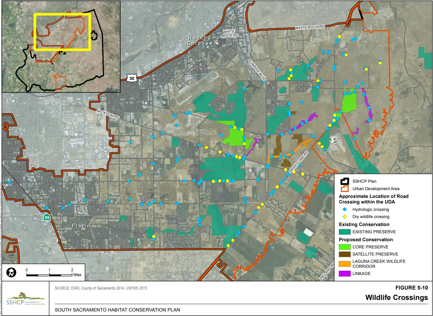
NATURE TRAIL-3 (Nature Trail Location): Nature trails will be located away from sensitive natural resources (e.g., vernal pools, riparian habitat, woodland habitat, Covered Species occurrences, raptor nesting sites, tricolored blackbird (Agelaius tricolor) colony sites). The Wildlife Agencies will determine the distance necessary to avoid impacts to sensitive natural resources.
NATURE TRAIL-4 (Biological Studies Prior to Nature Trail Design): Biological studies will be conducted within the area being considered for nature trail construction prior to project design. The studies will include land cover type mapping and focused species surveys and/or wetland delineations. The biological studies will include assessments of potential effects of trail construction on Preserve System resources, and recommendations for avoidance and minimization that may be incorporated into project siting, design, construction, and operation.
NATURE TRAIL-5 (Monitoring of Nature Trail Impacts): Impacts that could result from use of a nature trail within a Preserve will be monitored according to the Preserve Management Plan (Chapter 8) to ensure that uses do not conflict with the individual Preserve Management Plan. If use of a trail is found to conflict with the individual Preserve Management Plan, use of that trail will be discontinued until adjustments in the use can be made to reduce or eliminate conflicts. The Implementing Entity will make decisions about discontinuing or modifying use of a trail in consultation with the Preserve Manager or other applicable Preserve management agency or organization.
Condition 6. Avoid and Minimize Impacts When Re-Establishing or Establishing Wetlands
Section titled “Condition 6. Avoid and Minimize Impacts When Re-Establishing or Establishing Wetlands”As discussed in Chapter 7, the Plan Permittees anticipate that 389 acres of Vernal Pool habitat will be re-established or established 19 within the Plan Area as part of the SSHCP Conservation Strategy. Although re-establishment or establishment of vernal pools is a Measurable Objective under this Plan, if not done correctly, the action could have an adverse impact on existing vernal pools.
RE-ESTABLISHMENT/ESTABLISHMENT-1 (Vernal Pool): Re-establish or establish Vernal Pool Wetland according to the following guidelines:
- Re-establishment will always take priority over establishment of vernal pools. Establishment will be permitted only after it has been determined that sites with the potential to re-establish vernal pools no longer exist in the Plan Area or cannot be acquired through a willing seller/buyer agreement.
- When possible, re-established or established sites will be located adjacent to an existing Preserve(s) to maximize connectivity and Preserve area.
- Re-establishment or establishment will not result in direct or indirect adverse impacts to the hydrologic regime of existing vernal pools. Vernal pool reestablishment or establishment actions will not remove more than 10% of any existing vernal pool watershed, as defined by the SSHCP LIDAR analysis (see Section 3.3 and Conservation Action VPI1.2 in Table 7.1).
- Vernal pool re-establishment will attempt to restore the historical density and range of vernal pool sizes to the maximum extent feasible using historical aerial photography of the site, if available. Where aerial photography of the site’s historical conditions is not available, vernal pool re-establishment will include a range of pool sizes (area and depth) to accommodate the different habitat needs and life history characteristics of the vernal pool invertebrate Covered Species.
- Established vernal pools must be located on sites with vernal pool soils, defined as any Plan Area soil type where vernal pools currently exist.
- Established vernal pool sites will include a range of pool sizes to accommodate the different habitat needs and life history characteristics of the three vernal pool invertebrate Covered Species.
- The total density of vernal pools will not exceed 10% of the suitable soil areas in any vernal pool re-establishment and/or establishment site, unless it can be shown that the suitable areas of that site historically supported greater densities.
- Re-establishment or establishment may include inoculation when it is likely that no seed or cyst bank of vernal pool species remains at a site. Vernal Pool inocula will come from nearby vernal pools that are on the same geologic formation and soil type.
RE-ESTABLISHMENT/ESTABLISHMENT-2 (Vernal Pool Inocula Bank): Vernal pool reestablishment or establishment may include ‘soil inoculation’ when it is likely that no seed or cyst bank of vernal pool species remains at a re-establishment or establishment site.
- During conversion of Urban Development Area vernal pools to a developed land cover type, project proponents will excavate and retain soil from vernal pools following protocols developed by the SSHCP Technical Advisory Committee (Chapter 9).
- Inocula applied in re-established or established vernal pools must be harvested from a vernal pool that is on the same geologic formation and soil type shown on the County General Soil Map as the re-establishment/establishment site. Geologic formations and soil types will follow U.S. Department of Agriculture Soil Conservation Service’s 1993 Soil Survey of Sacramento County, California. Proposed off-site inocula sources must be approved by the Wildlife Agencies.
RE-ESTABLISHMENT/ESTABLISHMENT-3 (Re-Establishment/Establishment of Freshwater Marsh or Open Water Near Airports): During review of proposed re-establishment/establishment projects for freshwater marsh or open water on SSHCP Preserves, the Implementing Entity shall consider the potential for the location of the re-establishment/establishment projects to increase the risk of wildlife strikes or generation of ground fog at airports. If a re-establishment/ establishment project would result in (1) a net increase in open water or freshwater marsh acreage over baseline conditions 20 within 5 miles of Mather Field, Sacramento Executive Airport, or Franklin Field; or (2) replacement of open water/freshwater marsh habitat that is located 2 or more miles from Mather Field or Sacramento Executive Airport with open water/freshwater marsh habitat that is located less than 2 miles from those airports, a qualified biologist shall prepare a concise letter report. The letter report shall summarize the biologist’s findings regarding (1) the species likely to use the re-established/established habitat, (2) a rough order of magnitude estimate on the peak number of birds that might use the re-established/established habitat, and (3) potential movement patterns for birds using the re-established/established habitat and whether they might cross through the airport safety zones (e.g., to reach foraging habitat or another wildlife attractant). The letter report will also provide recommendations to the Implementing Entity on how they could reduce any of the identified wildlife hazards if there are any feasible means to do so that would not conflict with the biological goals and measurable objectives of the Conservation Plan.
Condition 7. Avoid and Minimize Impacts to Streams and Creeks
Section titled “Condition 7. Avoid and Minimize Impacts to Streams and Creeks”AMMs associated with Condition 7 must be applied to all Covered Activities where a stream or creek is located within a project footprint.
STREAM-1 (Laguna Creek Wildlife Corridor): A 150-foot setback measured from the top of the bank on both sides of the stream will be applied to Laguna Creek within the Urban Development Area (minimum 300-foot corridor width). If trails are located within the Laguna Creek Wildlife Corridor, the nearest edge of the trail will be located at least 80 feet from the top of the bank.
STREAM-2 (UDA Stream Setbacks): A 100-foot setback measured from the top of the bank on both sides of the stream channel will be applied to all streams listed in Table 5-1 (see also Figure 2-4). If a stream reach supports woody riparian vegetation, the setback will be equal to the riparian edge plus 25 feet or will be the setback defined above, whichever is greater. If trails are located within the Stream Setback, the nearest edge of the trail will be located at least 50 feet from the top of the bank.
Table 5-1 Stream Setback Minimum Requirements in the Urban Development Area
| Stream | Minimum Setback (from the Top of Bank Measured in Aerial Perspective) on Both Sides of the Stream |
|---|---|
| Elder Creek | 100 feet |
| Frye Creek | 100 feet or as depicted as part of the NewBridge development project hardline Preserve (see Appendix K) |
| Gerber Creek | 100 feet |
| Morrison Creek | 100 feet |
| Central Paseo | 100 feet or as depicted as part of the Cordova Hills development project hardline Preserve (Appendix K) |
| Sun Creek | 100 feet or as depicted as part of the Sun Creek development project hardline Preserve (see Appendix K) |
STREAM-3 (Minor Tributaries to UDA Streams): A 25-foot setback measured from the top of the bank on both sides of the stream channel will be applied to all avoided first and second order tributaries to the streams listed in Table 5-1 and Laguna Creek. Refer to Objective W6 in Chapter 7 (Table 7-1) regarding avoided first and second order tributaries. Trails are not permitted within headwater ephemeral Stream Setbacks.
STREAM-4 (Minimize Effects from Temporary Channel Re-Routing): When an Urban Development Covered Activity temporarily re-routes a stream, creek, or drainage, the re-routing will be completed in a manner that minimizes impacts to beneficial uses and habitat. The following measures will be employed to minimize disturbances that will adversely impact water quality:
- No equipment will be operated in areas of flowing or standing water.
- Construction materials and heavy equipment must be stored outside of the active flow of any waters.
- When work within waters is necessary, the entire stream flow will be diverted around the work area.
- In the event of rain, the disturbed in-water work area will be temporarily stabilized before water body flow exceeds the capacity of the diversion structure. The disturbed water body will be stabilized so that the disturbed areas will not come in contact with the flow.
- Once construction is complete, all project-introduced material (e.g., pipes, gravel, cofferdam, sandbags) must be removed, leaving the water as it was before construction. Excess materials will be disposed of at an appropriate disposal site.
- All work areas will be effectively isolated from stream flows using suitable control measures before commencement of any in-water work. The diverted stream flow will not be contaminated by construction activities. Structures for isolating the in-water work area and/or diverting the stream flow (e.g., cofferdam, geo-textile silt curtain) will not be removed until all disturbed areas are cleaned and stabilized.
- Any flow diversion used during construction will be designed in a manner to prevent pollution and minimize siltation, and will provide flows to downstream reaches. Flows will be maintained to support existing aquatic life, riparian wetlands, and habitat that may be located upstream and downstream from any temporary diversion.
- All surface waters, including ponded waters, will be diverted away from areas undergoing grading, construction, excavation, vegetation removal, and/or any other activity that may result in a discharge to waters.
- All temporary dewatering methods will be designed to have the minimum necessary impacts to waters to isolate the immediate work area. All dewatering methods will be installed such that natural flow is maintained upstream and downstream of the diversion area. Any temporary dams and diversions will be installed such that the diversion does not cause sedimentation, siltation, or erosion upstream or downstream of the diversion area. All dewatering methods will be removed immediately upon completion of diversion activities.
- A method of containment must be used below any bridge, boardwalk, and/or temporary crossing to prevent debris from falling into the waters through the entire duration of a project.
- If temporary surface water diversions and/or dewatering are anticipated, the Third-Party Project Proponent will develop and maintain on site a surface water diversion and/or dewatering plan. The plan(s) must be developed prior to initiation of any water diversions and will include the proposed method and duration of diversion activities. The plan(s) must be made available to Central Valley Water Board staff upon request.
- When work in a flowing stream is unavoidable and any dam or other artificial obstruction is being constructed, maintained, or placed in operation, sufficient water will be allowed at all times to pass downstream to maintain beneficial uses of waters below the dam. Construction, dewatering, and removal of temporary cofferdams will not violate the turbidity, settle-able matter, pH, temperature, or dissolved oxygen requirements of any Water Quality Control Plan.
- Any temporary dam or other artificial obstruction will only be built from clean materials such as sandbags, gravel bags, water dams, or clean/washed gravel that will cause little or no siltation. Stream flow will be temporarily diverted using gravity flow through temporary culverts or pipes, or pumped around the work site with the use of hoses.
STREAM-5 (Design for Stream Channel Re-Routing, Widening, or Deepening): When an Urban Development Covered Activity alters a stream, creek, or drainage by re-routing, widening, or deepening a channel, the project design will include the following:
- The main channel of a re-routed channel will be free to migrate laterally over its active and terrace floodplain.
- Channel geometry (plan, profile, and cross-section) of the site will be appropriate for the watershed location and physical/hydrologic condition.
- Local, native materials will be used as fill material to the extent practicable.
- Bioengineering techniques will be used for construction and maintenance of bank stabilization. Bioengineered bank stabilization structures will use vegetation in combination with bank reshaping; biodegradeable geotextile materials; and, in some cases, a minimal amount of rock or wood to the extent practicable to dissipate erosive energy. Third-Party Project Proponents will consult a professional engineer when considering using bioengineering techniques.
- All re-routed, widened, or deepened streams are required to establish Stream Setbacks with minimum widths required under STREAM-1, STREAM-2, or STREAM-3. All re-routed, widened, or deepened streams must re-establish/establish and maintain native Woody Riparian land cover and/or native Grassland Riparian land cover in the entire Stream Setback.
Condition 8. Avoid and Minimize Impacts to Covered Species from Utility and Utility Maintenance Covered Activities
Section titled “Condition 8. Avoid and Minimize Impacts to Covered Species from Utility and Utility Maintenance Covered Activities”AMMs associated with Condition 8 must be applied to all Covered Activities associated with construction and maintenance of infrastructure projects.
UTILITY-1 (Avian Collision Avoidance): Installation of new, or relocation of existing, utility poles, lines, and cell towers located within the Preserve System or within 1,000 feet of a Preserve boundary will be coordinated with the U.S. Fish and Wildlife Service and California Department of Fish and Wildlife. The applicant or relevant utility/service provider will install utility poles, lines, and cell towers in conformance with Avian Powerline Interaction Committee (APLIC) standards for collision-reducing techniques, as outlined in Reducing Avian Collisions with Power Lines: State of the Art in 2012 (APLIC 2012), or any superseding document issued by the APLIC.
UTILITY-2 (Utility Maintenance on Preserves): Utility maintenance inside SSHCP Preserves and SSHCP Preserve Setbacks containing vernal pools will occur only when vernal pools have been dry for 30 days, except in emergency situations related to human health and safety.
UTILITY-3 (Trenchless Construction Methods): Where a pipeline or conduit crosses an existing or planned Preserve or will be located between adjacent Preserves (e.g., under a roadway that has a Preserve on both sides), trenchless construction methods will be used to minimize impacts to the existing soil profile (including impacts to a hardpan or duripan) to maintain the perched aquifer in Vernal Pool Grassland land cover type.
UTILITY-4 (Siting of Entry and Exit Location): The entry and exit locations for the trenchless construction method (see Utility-3) will be sited to avoid impacts to vernal pools and Riparian Woodland, and to avoid direct take of SSHCP Covered Species.
Condition 9. Avoid and Minimize Impacts That Might Result From Removing or Breaching Levees to Establish or Re-establish Riparian Habitat
Section titled “Condition 9. Avoid and Minimize Impacts That Might Result From Removing or Breaching Levees to Establish or Re-establish Riparian Habitat”LEVEE-1 (Preparation of Hydrologic Analysis): Prior to approving a draft Preserve Management Plan that includes (1) modifying or breaching an existing levee, or (2) would place a potential impedance to high-water event flood-flows on the water side of an existing levee (including new riparian vegetation plantings or other new Preserve facilities), a hydrologic analysis will be conducted. The Preserve activity will only be implemented if the hydrologic analysis concludes that the activity will not result in a substantial increase in flood stage elevations or flood risk on lands outside the Preserve.
Condition 10. Avoid and Minimize Impacts That Might Result From Potential Residual Contamination of Preserves and Related Exposure of People to Such Hazardous Materials
Section titled “Condition 10. Avoid and Minimize Impacts That Might Result From Potential Residual Contamination of Preserves and Related Exposure of People to Such Hazardous Materials”HAZARDOUS MATERIALS-1 (Preparation of Phase I Environmental Site Assessment): Prior to the acquisition of a preserve site or implementation of a stream or riparian restoration project, a Phase I Environmental Site Assessment shall be conducted in general accordance with the American Society for Testing and Materials Standard Practice E1527-05. The purpose of this Environmental Site Assessment is to identify, to the extent feasible pursuant to the American Society for Testing and Materials Standard, recognized environmental conditions in connection with the potential site. The term ‘recognized environmental condition’ means the presence or likely presence of hazardous substances or petroleum products on the property under conditions that may indicate an existing release, a past release, or a material threat of release of these substances to the property. If the Phase 1 Environmental Site Assessment indicates the presence of a recognized environmental condition, the Implementing Entity shall consider the following options.
- Determine that the acquisition/project can proceed on the basis that the Habitat Plan goals and objectives can be met on the site even with the presence of a recognized environmental condition.
- Conduct a Phase II Environmental Site Assessment, including soil and groundwater testing, to further study the potential for contamination to limit the Implementing Entity’s management activities.
- If the results of the Phase I (or Phase II) Environmental Site Assessment indicate that the Habitat Plan goals and objectives cannot be met on the site, the Implementing Entity should not acquire the site.
HAZARDOUS MATERIALS-2 (Contingency Plan): As part of each Preserve Management Plan or site restoration plan, a Contingency Plan shall be prepared to address the actions that would be taken during construction in the event that unexpected contaminated soil or groundwater is discovered. The Contingency Plan shall include health and safety considerations, handling and disposal of wastes, reporting requirements, and emergency procedures. The Contingency Plan shall include a requirement that if evidence of contaminated materials is encountered during construction, construction would cease immediately and applicable requirements of the Comprehensive Environmental Release Compensation and Liability Act and the California Code of Regulations Title 22 regarding the disposal of waste would be implemented.
5.4.2 Covered Species Take Avoidance and Minimization Measures
Section titled “5.4.2 Covered Species Take Avoidance and Minimization Measures”The following section describes measures to avoid or minimize effects of Covered Activities on specific SSHCP Covered Species. Species-specific AMMs include species surveys, preconstruction surveys, and construction monitoring. Most species-specific AMMs require that species surveys be conducted if Covered Species modeled habitat is within the proposed Covered Activity footprint or within a specified distance of the proposed Covered Activity. Section 3.4 provides maps and descriptions of modeled habitat for each Covered Species. The AMMs described below apply to Covered Activities when Covered Species modeled habitat or a Covered Species occurrence are at a project site. The Implementing Entity and Wildlife Agencies may update specific SSHCP AMMs over the Permit Term to provide the best and most appropriate protective measures for a Covered Species.
General Covered Species Take Avoidance and Minimization Measures
Section titled “General Covered Species Take Avoidance and Minimization Measures”The following AMMs will apply to all Covered Activities that are required to implement Covered Species take AMMs.
SPECIES-1 (Litter Removal Program): A litter control program will be instituted for the entire project site. All workers will ensure that their food scraps, paper wrappers, food containers, cans, bottles, and other trash are deposited in covered or closed trash containers. All garbage will be removed from the project site at the end of each work day, and construction personnel will not feed or otherwise attract wildlife to the area where construction activities are taking place.
SPECIES-2 (No Pets in Construction Areas): To avoid harm and harassment of native species, workers and visitors will not bring pets onto a project site.
SPECIES-3 (Take Report): If accidental injury or death of any Covered Species occurs, workers will immediately inform the approved biologist or on-site monitor and site supervisor. The approved biologist or on-site monitor will phone the appropriate contact person at the Implementing Entity. The Implementing Entity will immediately contact the Wildlife Agencies by telephone. A memorandum will be provided to the Implementing Entity and Wildlife Agencies within 1 working day of the incident. The report will provide the date and location of the incident, number of individuals taken, the circumstances resulting in the take, and any corrective measures taken to prevent additional take.
SPECIES-4 (Post-Construction Compliance Report): A post-construction compliance report will be submitted to the SSHCP Implementing Entity within 30 calendar days of completion of construction activities or within 30 calendar days of any break in construction activity that lasts more than 30 days. The report will detail the construction start and completion dates, any information about meeting or failing to meet species take Avoidance and Minimization Measures (AMM), effectiveness of each AMM that was applied at the project site, and any known project effects to Covered Species.
Rare Plants
Section titled “Rare Plants”PLANT-1 (Rare Plant Surveys): If a Covered Activity project site contains modeled habitat for Ahart’s dwarf rush ( Juncus leiospermus var . ahartii) , Bogg’s Lake hedge-hyssop ( Gratiola heterosepala) , dwarf downingia ( Downingia pusilla), Legenere (Legenere limosa), pincushion navarretia ( Navarretia myersii), or Sanford’s arrowhead (Sagittaria sanfordii), the Covered Activity project site will be surveyed for the rare plant by an approved biologist and following the California Department of Fish and Wildlife (CDFW) rare plant survey protocols (CDFG 2009) or the most recent CDFW rare plant survey protocols. An approved biologist will conduct the field surveys and will identify and map plant species occurrences according to the protocols. See Chapter 10 for the process to submit survey information to the Plan Permittee and the Permitting Agencies.
PLANT-2 (Rare Plant Protection): If a rare plant listed in AMM PLANT-1 is detected within an area proposed to be disturbed by a Covered Activity or is detected within 250 feet of the area proposed to be disturbed by a Covered Activity, the Implementing Entity will assure one unprotected occurrence of the species is protected within a SSHCP Preserve before any ground disturbance occurs a the project site.
Sacramento and Slender Orcutt Grass
Section titled “Sacramento and Slender Orcutt Grass”Sacramento Orcutt grass (Orcuttia viscida) is a federally and state endangered species and is ranked by the California Native Plant Society as a California Rare Plant Rank 1B.1 species. Slender Orcutt grass (Orcuttia tenuis) is a federally threatened and state endangered species and is ranked by the California Native Plant Society as a California Rare Plant Rank 1B.1 species. Both Orcutt grasses are very rare, and the likelihood of finding new occurrences within the Plan Area is low. Due to their rarity, take of either of these species is not permitted under the SSHCP, with the exception of take related to Preserve management and monitoring (see Section 5.2.7, SSHCP Preserve System Covered Activities).
ORCUTT-1 (Orcutt Grass Surveys): If a Covered Activity project site is located within 1 mile of the Mather Core Recovery Area and contains the Vernal Pool land cover type, the project site will be surveyed for Sacramento and slender Orcutt grass by an approved biologist following California Department of Fish and Wildlife (CDFW) rare plant survey protocols (CDFG 2009) or most recent CDFW guidelines to determine if Sacramento and/or slender Orcutt grass is present. An approved biologist will conduct the field investigation to identify and map occurrences. See Chapter 10 for the process to conduct and submit survey information.
ORCUTT-2 (Orcutt Grass Protection): Where known or new Sacramento or slender Orcutt grass occurrences are found, they will be protected within an SSHCP Preserve that is at least 50 acres. The occurrence will be located interior to the Preserve at a distance of no less than 300 feet from the edge of the Preserve boundary. If a Third-Party Project Proponent encounters a previously undiscovered occurrence of Sacramento or slender Orcutt grass on a Covered Activity project site, the Third-Party Project Proponent will contact the Implementing Entity or Land Use Authority Permittee with authority over the project, who will coordinate with the Wildlife Agencies for written concurrence of avoidance to ensure that the project does not cause take of the species.
California Tiger Salamander
Section titled “California Tiger Salamander”To avoid direct and indirect effects of Covered Activities on California tiger salamander (Ambystoma californiense), the following AMMs will be implemented.
CTS-1 (California Tiger Salamander Daily Construction Schedule): Ground-disturbing Covered Activities within California tiger salamander modeled habitat (Figure 3-16) will occur outside the breeding and dispersal season (occur after July 31 and before October 15), to the maximum extent practicable. If Covered Activities must be implemented in modeled habitat (Figure 3-16) during the breeding and dispersal season (after October 15 and before July 31), construction activities will not start until 30 minutes after sunrise and must be complete 30 minutes prior to sunset.
CTS-2 (California Tiger Salamander Exclusion Fencing): If a Covered Activity must be implemented in modeled habitat (Figure 3-16) during the breeding and dispersal season (after October 15 and before July 31), exclusion fencing will be installed around the project footprint before October 15. Temporary high-visibility construction fencing will be installed along the edge of work areas, and exclusion fencing will be installed immediately outside of the temporary high-visibility construction fencing to exclude California tiger salamanders from entering the construction area or becoming entangled in the construction fencing. Exclusion fencing will be at least 1 foot tall and be buried at least 6 inches below the ground to prevent salamanders from going under the fencing. Fencing will remain in place until all construction activities within the construction area are complete. No project activities will occur outside the delineated project footprint. An approved biologist must inspect the exclusion fencing and project site every morning before 7:00 a.m. for integrity and for any entrapped California tiger salamanders. If a California tiger salamander is encountered, refer to CTS-5, below. (However, the Implementing Entity may, with approval of the U.S. Fish and Wildlife Service (USFWS) and California Department of Fish and Wildlife (CDFW), determine that it is appropriate for a Covered Activity project to not implement CTS-2 for certain long and linear roadway Covered Activity projects if it appears that the exclusion fencing will likely trap individuals or cause more take of California tiger salamander than it would prevent.)
CTS-3 (California Tiger Salamander Monitoring): If Covered Activities must be implemented in modeled habitat (Figure 3-16), an approved biologist experienced with California tiger salamander identification and behavior will monitor the project site, including the integrity of any exclusion fencing. The approved biologist will be on site daily while construction-related activities are taking place, and will inspect the project site for California tiger salamander every morning before 7:00 a.m., or prior to construction activities. As required by BMP-8 (Training of Construction Staff), the approved biologist will also train construction personnel on the required California tiger salamander avoidance procedures, exclusion fencing, and correct protocols in the event that a California tiger salamander enters an active construction zone. If a California tiger salamander is encountered, refer to CTS-5, below.
CTS-4 (Avoid California Tiger Salamander Entrapment): If Covered Activities must be implemented in modeled habitat, all excavated steep-walled holes or trenches more than 6 inches deep will be covered with plywood (or similar material) or provided with one or more escape ramps constructed of earth fill or wooden planks at the end of each work day or 30 minutes prior to sunset, whichever occurs first. All steep-walled holes or trenches will be inspected by the approved biologist each morning to ensure that no wildlife has become entrapped. All construction pipes, culverts, similar structures, construction equipment, and construction debris left overnight within California tiger salamander modeled habitat will be inspected for California tiger salamanders by the approved biologist prior to being moved. If a California tiger salamander is encountered, refer to CTS-5, below.
CTS-5 (California Tiger Salamander Encounter Protocol): If a California tiger salamander is encountered during construction activities, the approved biologist will notify the Wildlife Agencies immediately (California Department of Fish and Wildlife (CDFW) and U.S. Fish and Wildlife Service (USFWS)). Construction activities will be suspended in a 100-foot radius of the animal until the animal is relocated by an approved biologist with appropriate handling permits from the Wildlife Agencies. Prior to relocation, the approved biologist will notify the Wildlife Agencies to determine the appropriate procedures related to relocation. If the animal is handled, a report will be submitted, including date(s), location(s), habitat description, and any corrective measures taken to protect the salamander, within 1 business day to the Wildlife Agencies. The biologist will report any take of listed species to USFWS and CDFW immediately. Any worker who inadvertently injures or kills a California tiger salamander or who finds dead, injured, or entrapped California tiger salamander(s) must immediately report the incident to the approved biologist.
CTS-6 (Erosion Control Materials in California Tiger Salamander Habitat): If erosion control (BMP-2) is implemented within California tiger salamander modeled habitat (Figure 3-16), non-entangling erosion control material will be used to reduce the potential for entrapment. Tightly woven fiber netting (mesh size less than 0.25 inch) or similar material will be used to ensure that salamanders are not trapped (no monofilament). Coconut coir matting and fiber rolls with burlap are examples of acceptable erosion control materials. This limitation will be communicated to the contractor through use of special provisions included in the bid solicitation package.
CTS-7 (Rodent Control): CTS-7 only applies to projects that are within California tiger salamander modeled habitat (Figure 3-16) and on Covered Activities. Rodent control will be allowed only in developed portions of a Covered Activity project site. Where rodent control is allowed, the method of rodent control will comply with the methods of rodent control discussed in the 4(d) Rule published in the U.S. Fish and Wildlife Service’s (2004) final listing rule for tiger salamander.
Western Spadefoot
Section titled “Western Spadefoot”To avoid direct and indirect effects of Covered Activities on western spadefoot (Spea hammondii), the following AMMs will be implemented.
WS-1 (Western Spadefoot Work Window): Ground-disturbing Covered Activities within western spadefoot modeled habitat (Figure 3-17) will occur outside the breeding and dispersal season (after May 15 and before October 15), to the maximum extent practicable.
WS-2 (Western Spadefoot Exclusion Fencing): If Covered Activities must be implemented in modeled habitat (Figure 3-17) after October 15 and before May 15, exclusion fencing will be installed around the project footprint before October 15, and the project site must be monitored by an approved biologist following rain events. Temporary highvisibility construction fencing will be installed along the edge of work areas, and silt fencing will be installed immediately behind the temporary high-visibility construction fencing to exclude western spadefoot from entering the construction area. Fencing will remain in place until all construction activities within the construction area are completed. No project activities will occur outside the delineated project footprint. If a western spadefoot is encountered, refer to WS-6, below.
WS-3 (Western Spadefoot Monitoring): If Covered Activities must be implemented in modeled habitat (Figure 3-17) in the breeding and dispersal season (after October 15 and before May 15), an approved biologist experienced with western spadefoot identification and behavior will monitor the project site, including the integrity of any exclusion fencing. The approved biologist will be on site daily while constructionrelated activities are taking place, and will inspect the project site daily for western spadefoot prior to construction activities. The approved biologist will also train construction personnel on the required avoidance procedures, exclusion fencing, and protocols in the event that a western spadefoot enters an active construction zone (i.e., outside the buffer zone). If a western spadefoot is encountered, refer to WS-6, below.
WS-4 (Avoid Western Spadefoot Entrapment): If a Covered Activity occurs in western spadefoot modeled habitat (Figure 3-17), all excavated steep-walled holes and trenches more than 6 inches deep will be covered with plywood (or similar material) or provided with one or more escape ramps constructed of earth fill or wooden planks at the end of each work day or 30 minutes prior to sunset, whichever occurs first. All steep-walled holes and trenches will be inspected by the approved biologist each morning to ensure that no wildlife has become entrapped. All construction pipes, culverts, similar structures, construction equipment, and construction debris left overnight within western spadefoot modeled habitat will be inspected for western spadefoot by the approved biologist prior to being moved. If a western spadefoot is encountered, refer to WS-6, below.
WS-5 (Erosion Control Materials in Western Spadefoot Habitat): If erosion control (BMP-2) is implemented within western spadefoot modeled habitat (Figure 3-17), non-entangling erosion control material will be used to reduce the potential for entrapment. Tightly woven fiber netting (mesh size less than 0.25 inch) or similar material will be used to ensure that western spadefoots are not trapped (no monofilament). Coconut coir matting and fiber rolls containing burlap are examples of acceptable erosion control materials.
WS-6 (Western Spadefoot Encounter Protocol): If Covered Activities must be implemented in modeled habitat (Figure 3-17) during the breeding and dispersal season (after October 15 and before May 15), and a western spadefoot is encountered during construction activities, the approved biologist will notify the Wildlife Agencies immediately. Construction activities will be suspended in a 100-foot radius of the animal until the animal leaves the project site on its own volition. If necessary, the approved biologist will notify the Wildlife Agencies to determine the appropriate procedures related to relocation. If the animal is handled, a report will be submitted, including date(s), location(s), habitat description, and any corrective measures taken to protect the western spadefoot within 1 business day to the Wildlife Agencies. The biologist will report any take of listed species to the U.S. Fish and Wildlife Service and California Department of Fish and Wildlife immediately. Any worker who inadvertently injures or kills a western spadefoot or who finds dead, injured, or entrapped western spadefoot(s) must immediately report the incident to the approved biologist.
Giant Gartersnake
Section titled “Giant Gartersnake”To avoid direct and indirect effects of Covered Activities on giant gartersnake (Thamnophis gigas), the following AMMs will be implemented.
GGS-1 (Giant Gartersnake Surveys): If the SSHCP giant gartersnake modeled habitat maps (Figure 3-18) show that modeled habitat for giant gartersnake is present within a Covered Activity’s project footprint or within 300 feet of a project footprint, then an approved biologist will conduct a field investigation to delineate giant gartersnake aquatic habitat within the project footprint and adjacent areas within 300 feet of the project footprint. In addition to the SSHCP land cover types shown in Figure 3-18, giant gartersnake aquatic habitat includes, but is not limited to, low-gradient streams and creeks, open water, freshwater marsh, agricultural ditches, and rice fields. Adjacent parcels under different land ownership will be surveyed only if access is granted or if the parcels are visible from authorized areas. The Third-Party Project Proponent will map all existing or potential sites and provide these maps to the Local Land Use Permittees and the Implementing Entity. Locations of delineated giant gartersnake habitat must also be noted on plans that are submitted to a Local Land Use Permittee. The applicant will use this information to finalize project design. Covered Activities may occur throughout the year as long as giant gartersnake habitat is identified and fully avoided. Otherwise, Covered Activities must comply with GGS-2 through GGS-8, below. See Chapter 10 for the process to conduct and submit survey information.
GGS-2 (Giant Gartersnake Work Window): Covered Activities that do not fully avoid giant gartersnake modeled habitat (Figure 3-18) will be conducted during the snake’s active season. Construction and ground-disturbing activities will be initiated after May 1 and will end prior to September 15. If it appears that construction activities may go beyond September 15, the Third-Party Project Proponent or Plan Permittee will contact the Local Land Use Permittee and the Implementing Entity as soon as possible, but not later than September 1. The Local Land Use Permittee and the Implementing Entity will discuss with the Wildlife Agencies additional measures necessary to minimize take.
GGS-3 (Giant Gartersnake Monitoring): If a Covered Activity is occurring in giant gartersnake modeled habitat (Figure 3-18), an approved biologist experienced with giant gartersnake identification and behavior will monitor the project site, including the integrity of any exclusion fencing. The approved biologist will be on site daily while construction-related activities are taking place in aquatic habitat or within 300 feet of aquatic habitat, and will inspect the project site daily for giant gartersnake prior to construction activities. If a giant gartersnake is encountered, refer to GGS-7. The approved biologist will also train construction personnel on the required avoidance procedures, exclusion fencing, and protocols in the event that a giant gartersnake enters an active construction zone (i.e., outside the buffer zone).
GGS-4 (Giant Gartersnake Habitat Dewatering and Exclusion): If construction activities will occur in giant gartersnake aquatic habitat, aquatic habitat will be dewatered and then remain dry and absent of aquatic prey (e.g., fish and tadpoles) for 15 days prior to initiation of construction activities. If complete dewatering is not possible, the Implementing Entity will be contacted to determine what additional measures may be necessary to minimize effects to giant gartersnake. After aquatic habitat has been dewatered 15 days prior to construction activities, exclusion fencing will be installed extending a minimum of 300 feet into adjacent uplands to isolate both the aquatic and adjacent upland habitat. Exclusionary fencing will be erected 36 inches above ground and buried at least 6 inches below the ground to prevent snakes from attempting to move under the fence into the construction area. In addition, high-visibility fencing will be erected to identify the construction limits and to protect adjacent habitat from encroachment of personnel and equipment. Giant gartersnake habitat outside construction fencing will be avoided by all construction personnel. The fencing and the work area will be inspected by the approved biologist to ensure that the fencing is intact and that no snakes have entered the work area before the start of each work day. The fencing will be maintained by the contractor until completion of the project. If giant gartersnake is encountered, refer to GGS-7, below.
GGS-5 (Avoid Giant Gartersnake Entrapment): If a Covered Activity occurs in giant gartersnake modeled habitat (Figure 3-18), all excavated steep-walled holes and trenches more than 6 inches deep will be covered with plywood (or similar material) or provided with one or more escape ramps constructed of earth fill or wooden planks at the end of each work day or 30 minutes prior to sunset, whichever occurs first. All steep-walled holes and trenches will be inspected by the approved biologist each morning to ensure that no wildlife has become entrapped. All construction pipes, culverts, similar structures, construction equipment, and construction debris left overnight within giant gartersnake modeled habitat will be inspected for giant gartersnake by the approved biologist prior to being moved. If a giant gartersnake is encountered, refer to GGS-7.
GGS-6 (Erosion Control Materials in Giant Gartersnake Habitat): If erosion control (BMP2) is implemented within giant gartersnake modeled habitat (Figure 3-18), nonentangling erosion control material will be used to reduce the potential for entrapment. Tightly woven fiber netting (mesh size less than 0.25 inch) or similar material will be used to ensure snakes are not trapped (no monofilament). Coconut coir matting and fiber rolls containing burlap are examples of acceptable erosion control materials.
GGS-7 (Giant Gartersnake Encounter Protocol): If a giant gartersnake is encountered during construction activities, the approved biologist will notify the Wildlife Agencies immediately. Construction activities will be suspended in a 100-foot radius of the animal until the animal leaves the project site on its own volition. If necessary, the approved biologist will notify the Wildlife Agencies to determine the appropriate procedures related to relocation. If the animal is handled, a report will be submitted, including date(s), location(s), habitat description, and any corrective measures taken to protect the giant gartersnake within 1 business day to the Wildlife Agencies. The biologist will report any take of listed species to the U.S. Fish and Wildlife Service immediately. Any worker who inadvertently injures or kills a giant gartersnake or who finds one dead, injured, or entrapped must immediately report the incident to the approved biologist.
GGS-8 (Giant Gartersnake Post-Construction Restoration): After completion of grounddisturbing Covered Activities, the applicant will remove any temporary fill and construction debris and will restore temporarily disturbed areas to pre-project conditions. Restoration work includes such activities as re-vegetating the banks and active channels with a seed mix similar to pre-project conditions. Appropriate methods and plant species used to re-vegetate such areas will be determined on a site-specific basis in consultation with the Implementing Entity. Restoration work may include replanting emergent aquatic vegetation. Refer to the U.S. Fish and Wildlife Service’s (USFWS) Guidelines for the Restoration and/or Replacement of Giant Gartersnake Habitat (USFWS 1997), or the most current USFWS guidelines at the time of the activity. A photo documentation report showing pre- and post-project conditions will be submitted to the Implementing Entity 1 month after implementation of the restoration.
Western Pond Turtle
Section titled “Western Pond Turtle”To avoid direct and indirect effects of Covered Activities on western pond turtle (Actinemys marmorata), the following AMMs will be implemented.
WPT-1 (Western Pond Turtle Surveys): If the SSHCP western pond turtle modeled habitat maps (Figure 3-19) show that modeled habitat for western pond turtle is present within a Covered Activity’s project footprint or within 300 feet of a project footprint, then an approved biologist will conduct a field investigation to delineate western pond turtle aquatic habitat within the project footprint and within 300 feet of the project footprint. In addition to the SSHCP land cover types shown in Figure 3-19, western pond turtle aquatic habitat includes, but is not limited to, low-gradient streams and creeks, open water, freshwater marsh, and rice fields. Adjacent parcels under different land ownership will be surveyed only if access is granted or if the parcels are visible from authorized areas. The Third-Party Project Proponent will map all existing or potential sites and provide those maps to the Local Land Use Permittees and the Implementing Entity. Locations of delineated western pond turtle habitat must also be noted on plans that are submitted to a Local Land Use Permittee. The applicant will use this information to finalize project design. Covered Activities may occur throughout the year as long as western pond turtle habitat is identified and fully avoided. Otherwise, Covered Activities must comply with WPT-2 through WPT-9. See Chapter 10 for the process to conduct and submit survey information.
WPT-2 (Western Pond Turtle Work Window): Maintenance and improvements to existing structures may occur throughout the year as long as western pond turtle habitat is identified and avoided, and movement of equipment is confined to existing roads. Otherwise, construction and ground-disturbing Covered Activities must be conducted outside of western pond turtle’s active season. Construction and ground-disturbing activities will be initiated after May 1 and will commence prior to September 15. If it appears that construction activities may go beyond September 15, the appropriate Plan Permittee will contact the Local Land Use Permittee and the Implementing Entity as soon as possible, but not later than September 1, to determine if additional measures are necessary to minimize take.
WPT-3 (Western Pond Turtle Monitoring): If a Covered Activity is occurring in western pond turtle modeled habitat (Figure 3-19), an approved biologist experienced with western pond turtle identification and behavior will monitor the project site, including the integrity of any exclusion fencing. The approved biologist will be on site daily while construction-related activities are taking place in aquatic habitat or within 300 feet of aquatic habitat, and will inspect the project site daily for western pond turtle prior to construction activities. The approved biologist will also training construction personnel on the required avoidance procedures, exclusion fencing, and protocols in the event that a western pond turtle enters an active construction zone (i.e., outside the buffer zone).
WPT-4 (Western Pond Turtle Habitat Dewatering and Exclusion): If construction activities will occur in western pond turtle aquatic habitat, aquatic habitat for the turtle will be dewatered and then remain dry and absent of aquatic prey (e.g., crustaceans and other aquatic invertebrates) for 15 days prior to the initiation of construction activities. If complete dewatering is not possible, the Implementing Entity will be contacted to determine what additional measures may be necessary to minimize effects to western pond turtle. After aquatic habitat has been dewatered 15 days prior to construction activities, exclusion fencing will be installed extending a minimum of 300 feet into adjacent uplands to isolate both the aquatic and adjacent upland habitat. Exclusionary fencing will be erected 36 inches above ground and buried at least 6 inches below the ground to prevent turtles from attempting to burrow or move under the fence into the construction area. In addition, high-visibility fencing will be erected to identify construction limits and to protect adjacent habitat from encroachment of personnel and equipment. Western pond turtle habitat outside construction fencing will be avoided by all construction personnel. The fencing and work area will be inspected by the approved biologist to ensure that the fencing is intact and that no turtles have entered the work area before the start of each work day. Fencing will be maintained by the contractor until completion of the project. If, after exclusion fencing and dewatering, western pond turtles are found within the project footprint or within 300 feet of the project footprint, the Third-Party Project Proponent will discuss the next best steps with the Implementing Entity and Wildlife Agencies.
WPT-5 (Avoid Western Pond Turtle Entrapment): If a Covered Activity occurs within western pond turtle modeled habitat (Figure 3-19), all excavated steep-walled holes and trenches more than 6 inches deep will be covered with plywood (or similar material) or provided with one or more escape ramps constructed of earth fill or wooden planks at the end of each work day or 30 minutes prior to sunset, whichever occurs first. All steep-walled holes and trenches will be inspected by the approved biologist each morning to ensure that no wildlife has become entrapped. All construction pipes, culverts, similar structures, construction equipment, and construction debris left overnight within western pond turtle modeled habitat will be inspected for western pond turtle by the approved biologist prior to being moved.
WPT-6 (Erosion Control Materials in Western Pond Turtle Habitat): If erosion control (BMP-2) is implemented within western pond turtle modeled habitat (Figure 3-19), non-entangling erosion control material will be used to reduce the potential for entrapment. Tightly woven fiber netting (mesh size less than 0.25 inch) or similar material will be used to ensure that turtles are not trapped (no monofilament). Coconut coir matting and fiber rolls containing burlap are examples of acceptable erosion control materials.
WPT-7 (Western Pond Turtle Modeled Habitat Speed Limit): Covered Activity construction and maintenance vehicles will observe a 20-mile-per-hour speed limit within western pond turtle modeled upland habitat (Figure 3-19).
WPT-8 (Western Pond Turtle Encounter Protocol): If a western pond turtle is encountered during construction activities, the approved biologist will notify the Wildlife Agencies immediately. Construction activities will be suspended in a 100-foot radius of the animal until the animal leaves the project site on its own volition. If necessary, the approved biologist will notify the Wildlife Agencies to determine the appropriate procedures related to relocation. If the animal is handled, a report will be submitted, including date(s), location(s), habitat description, and any corrective measures taken to protect the turtle, within 1 business day to the Wildlife Agencies. The biologist will report any take of listed species to the U.S. Fish and Wildlife Service immediately. Any worker who inadvertently injures or kills a western pond turtle or who finds one dead, injured, or entrapped must immediately report the incident to the approved biologist.
WPT-9 (Western Pond Turtle Post-Construction Restoration): After completion of grounddisturbing Covered Activities, the applicant will remove any temporary fill and construction debris and will restore temporarily disturbed areas to pre-project conditions. Restoration work includes such activities as re-vegetating the banks and active channels with a seed mix similar to pre-project conditions. Appropriate methods and plant species used to re-vegetate such areas will be determined on a site-specific basis in consultation with the Implementing Entity. Restoration work may include replanting emergent aquatic vegetation and placing appropriate artificial or natural basking areas in waterways and wetlands. A photo documentation report showing preand post-project conditions will be submitted to the Implementing Entity 1 month after implementation of the restoration.
Tricolored Blackbird
Section titled “Tricolored Blackbird”To avoid direct and indirect effects of Covered Activities on tricolored blackbird (Agelaius tricolor), the following AMMs will be implemented.
TCB-1 (Tricolored Blackbird Surveys): If modeled habitat for tricolored blackbird is present within a Covered Activity’s project footprint or within 500 feet of a project footprint, then an approved biologist will conduct a field investigation to determine if existing or potential nesting or foraging sites are present within the project footprint and adjacent areas within 500 feet of the project footprint. Adjacent parcels under different land ownership will be surveyed only if access is granted or if the parcels are visible from authorized areas. Within the Plan Area, potential tricolor blackbird nest sites are often associated with freshwater marsh and seasonal wetlands, or in thickets of willow, blackberry, wild rose, thistle, and other thorny vegetation. Tricolored blackbirds are also known to nest in crops associated with dairy farms. Foraging habitat is associated with annual grasslands, wet and dry vernal pools and other seasonal wetlands, agricultural fields (such as large tracts of alfalfa and pastures with continuous haying schedules and recently tilled fields), cattle feedlots, and dairies. The Third-Party Project Proponent will map all existing or potential nesting or foraging sites and provide these maps to the Local Land Use Permittees and Implementing Entity. Nesting sites must also be noted on plans that are submitted to a Local Land Use Permittee. See Chapter 10 for the process to conduct and submit survey information.
TCB-2 (Tricolored Blackbird Pre-Construction Surveys): Pre-construction surveys will be required to determine if active nests are present within a project footprint or within 500 feet of a project footprint if existing or potential nest sites were found during design surveys and construction activities will occur during the breeding season (March 1 through September 15). An approved biologist will conduct pre-construction surveys within 30 days and within 3 days of ground-disturbing activities, and within the proposed project footprint and 500 feet of the proposed project footprint to determine the presence of nesting tricolored blackbird. Pre-construction surveys will be conducted during the breeding season (March 1 through August 31). Surveys conducted in February (to meet pre-construction survey requirements for work starting in March) must be conducted within 14 days and 3 days in advance of ground-disturbing activities. If a nest is present, then TCB-3 and TCB-4 will be implemented. The approved biologist will inform the Land Use Authority Permittee and the Implementing Entity of species locations, and they in turn will notify the Wildlife Agencies.
TCB-3 (Tricolored Blackbird Nest Buffer): If active nests are found within the project footprint or within 500 feet of any project-related Covered Activity, the Third-Party Project Proponent will establish a 500-foot temporary buffer around the active nest until the young have fledged.
TCB-4 (Tricolored Blackbird Nest Buffer Monitoring): If nesting tricolored blackbirds are present within the project footprint or within 500 feet of any project-related Covered Activity, then an approved biologist experienced with tricolored blackbird behavior will be retained by the Third-Party Project Proponent to monitor the nest throughout the nesting season and to determine when the young have fledged. The approved biologist will be on site daily while construction-related activities are taking place near the disturbance buffer. Work within the nest disturbance buffer will not be permitted. If the approved biologist determines that tricolored blackbirds are exhibiting agitated behavior, construction will cease until the buffer size is increased to a distance necessary to result in no harm or harassment to the nesting tricolored blackbirds. If the biologist determines that the colonies are at risk, a meeting with the Third-Party Project Proponent, Implementing Entity, and Wildlife Agencies will be held to determine the best course of action to avoid nest abandonment or take of individuals. The approved biologist will also train construction personnel on the required avoidance procedures, buffer zones, and protocols in the event that a tricolored blackbird flies into an active construction zone (i.e., outside the buffer zone).
TCB-5 (Timing of Pesticide Use and Harvest Timing on Agricultural Preserves): On SSHCP Agricultural Preserves, pesticides (including herbicides) will not be applied from January 1 through July 15.
Swainson’s Hawk
Section titled “Swainson’s Hawk”To avoid direct and indirect effects of Covered Activities on Swainson’s hawk (Buteo swainsoni), the following AMMs will be implemented.
SWHA-1 (Swainson’s Hawk Surveys): If modeled habitat for Swainson’s hawk (Figure 3-25) is present within a Covered Activity’s project footprint or within 0.25 mile of a project footprint, then an approved biologist will conduct a survey to determine if existing or potential nesting sites are present within the project footprint and adjacent areas within 0.25 mile of the project footprint. Adjacent parcels under different land ownership will be surveyed only if access is granted or if the parcels are visible from authorized areas. Nest sites are often associated with Riparian land cover, but also include lone trees in fields, trees along roadways, and trees around structures. Nest trees may include, but are not limited to, Fremont’s cottonwood (Populus fremontii), oaks ( Quercus spp.), willows ( Salix spp.), walnuts ( Juglans spp.), eucalyptus ( Eucalyptus spp.), pines ( Pinus spp.), and Deodar cedar (Cedrus deodara). The Third-Party Project Proponent will map all existing and potential nesting sites and provide these maps to the Local Land Use Permittees and Implementing Entity. Nesting sites must also be noted on plans that are submitted to a Local Land Use Permittee. See Chapter 10 for the process to conduct and submit survey information.
SWHA-2 (Swainson’s Hawk Pre-Construction Surveys): Pre-construction surveys will be required to determine if active nests are present within a project footprint or within 0.25 mile of a project footprint if existing or potential nest sites were found during initial surveys and construction activities will occur during the breeding season (March 1 through September 15). An approved biologist will conduct pre-construction surveys within 30 days and 3 days of ground-disturbing activities to determine presence of nesting Swainson’s hawk. Pre-construction surveys will be conducted during the breeding season (March 1 through September 15). If a nest is present, then SWHA-3 and SWHA-4 will be implemented. The approved biologist will inform the Land Use Authority Permittee and Implementing Entity of species locations, and they in turn will notify the Wildlife Agencies.
SWHA-3 (Swainson’s Hawk Nest Buffer): If active nests are found within the project footprint or within 0.25 mile of any project-related Covered Activity, the Third-Party Project Proponent will establish a 0.25 mile disturbance buffer around the active nest until the young have fledged, with concurrence from the Wildlife Agencies.
SWHA-4 (Swainson’s Hawk Nest Buffer Monitoring): If nesting Swainson’s hawks are present within the project footprint or within 0.25 mile of any project-related Covered Activity, then an approved biologist experienced with Swainson’s hawk behavior will be retained by the Third-Party Project Proponent to monitor the nest throughout the nesting season and to determine when the young have fledged. The approved biologist will be on site daily while construction-related activities are taking place within the buffer. Work within the temporary nest disturbance buffer can occur with the written permission of the Implementing Entity and Wildlife Agencies. If nesting Swainson’s hawks begin to exhibit agitated behavior, such as defensive flights at intruders, getting up from a brooding position, or flying off the nest, the approved biologist will have the authority to shut down construction activities. If agitated behavior is exhibited, the biologist, Third-Party Project Proponent, Implementing Entity, and Wildlife Agencies will meet to determine the best course of action to avoid nest abandonment or take of individuals. The approved biologist will also train construction personnel on the required avoidance procedures, buffer zones, and protocols in the event that a Swainson’s hawk flies into an active construction zone (i.e., outside the buffer zone).
Greater Sandhill Crane
Section titled “Greater Sandhill Crane”To avoid direct and indirect effects of Covered Activities on greater sandhill crane (Grus canadensis), the following AMMs will be implemented.
GSC-1 (Greater Sandhill Crane Surveys): If modeled habitat for greater sandhill crane (Figure 3-22) is present within a Covered Activity’s project footprint or within 0.5 mile of a project footprint, then an approved biologist will conduct a field investigation to determine if existing or potential roosting sites are present within the project footprint and adjacent areas within 0.5 mile of the project footprint. Adjacent parcels under different land ownership will be surveyed only if access is granted or if the parcels are visible from authorized areas. Roosting sites within the Plan Area are often associated with flooded fields, seasonal wetlands, and freshwater marsh. The Third-Party Project Proponent will map all existing or potential roosting sites and provide these maps to the Local Land Use Permittees and Implementing Entity. Roosting sites must also be noted on plans that are submitted to a Local Land Use Permittee. See Chapter 10 for the process to conduct and submit survey information.
GSC-2 (Greater Sandhill Crane Pre-Construction Surveys): Pre-construction surveys will be required to determine if active roosting sites are present within a project footprint or within 0.5 mile of a project footprint if existing or potential roosting sites were found during initial surveys and construction activities will occur when wintering flocks are present within the Plan Area (September 1 through March 15). An approved biologist will conduct pre-construction surveys within 15 days of ground-disturbing activities, and within 0.5 mile of a project footprint, to determine presence of roosting greater sandhill cranes. Pre-construction surveys will be conducted September 1 through March 15, when wintering flocks are present within the Plan Area. If birds are present, then GSC-3, GSC-4, and GSC-5 will be implemented. The approved biologist will inform the Land Use Authority Permittee and Implementing Entity of species locations, and they in turn will notify the Wildlife Agencies.
GSC-3 (Greater Sandhill Crane Roosting Buffer): If active roosting sites are found within the project footprint or within 0.5 mile of any project-related Covered Activity, the ThirdParty Project Proponent will establish a 0.5 mile temporary roosting disturbance buffer around the roosting site until the cranes have left.
GSC-4 (Greater Sandhill Crane Visual Barrier): Greater sandhill cranes have low tolerance for human disturbance, and such disturbance has caused cranes to abandon foraging and roosting sites. Repeat disturbance affects their ability to feed and store energy needed for survival. If project-related activities occur within 0.5 mile of a known roosting site as identified by surveys conducted during implementation of GSC-1 or GSC-2, a visual barrier will be constructed.
GSC-5 (Greater Sandhill Crane Roosting Buffer Monitoring): If roosting sites are found within the project footprint or within 0.50 mile of any project-related Covered Activity, an approved biologist experienced with greater sandhill crane behavior will be retained by the Third-Party Project Proponent to monitor the roosting site throughout the roosting season and to determine when the birds have left. The approved biologist will be on site daily while construction-related activities are taking place within the disturbance buffer. Work within the temporary disturbance buffer can only occur with the written permission of the Implementing Entity and Wildlife Agencies. If greater sandhill cranes are abandoning their roosting and/or forage sites, the approved biologist will have the authority to shut down construction activities. If roost abandonment occurs, the approved biologist, Third-Party Project Proponent, Implementing Entity, and Wildlife Agencies will meet to determine the best course of action to avoid harm and harassment of individuals. The approved biologist will also train construction personnel on the avoidance procedures, buffer zones, and protocols in the event that greater sandhill cranes move into an active construction zone (i.e., outside the buffer zone).
Western Burrowing Owl
Section titled “Western Burrowing Owl”To avoid direct and indirect effects of Covered Activities on western burrowing owl (Athene cunicularia), the following AMMs will be implemented.
WBO-1 (Western Burrowing Owl Surveys): Surveys within modeled habitat are required for both the breeding and non-breeding season. If the project site falls within modeled habitat, an approved biologist will survey the project site and map all burrows, noting any burrows that may be occupied. Occupied burrows are often (but not always) indicated by tracks, feathers, egg shell fragments, pellets, prey remains, and/or excrement. Surveying and mapping will be conducted by the approved biologist while walking transects throughout the entire project site plus all accessible areas within a 250-foot radius from the project site. The centerline of these transects will be no more than 50 feet apart and will vary in width to account for changes in terrain and vegetation that can preclude complete visual coverage of the area. For example, in hilly terrain with patches of tall grass, transects will be closer together, and in open areas with little vegetation, they can be 50 feet apart. This methodology is consistent with current survey protocols for this species (California Burrowing Owl Consortium 1993). Adjacent parcels under different land ownership will be surveyed only if access is granted or if the parcels are visible from authorized areas. If suitable habitat is identified during the initial survey, and if the project does not fully avoid the habitat, pre-construction surveys will be required. Burrowing owl habitat is fully avoided if project-related activities do not impinge on a 250foot buffer established by the approved biologist around suitable burrows. See Chapter 10 for the process to conduct and submit survey information.
WBO-2 (Western Burrowing Owl Pre-Construction Surveys): Prior to any Covered Activity ground disturbance, an approved biologist will conduct pre-construction surveys in all areas that were identified as suitable habitat during the initial surveys. The purpose of the pre-construction surveys is to document the presence or absence of burrowing owls on the project site, particularly in areas within 250 feet of construction activities. To maximize the likelihood of detecting owls, the pre-construction survey will last a minimum of 3 hours. The survey will begin 1 hour before sunrise and continue until 2 hours after sunrise (3 hours total), or begin 2 hours before sunset and continue until 1 hour after sunset. Additional time may be required for large project sites. A minimum of two pre-construction surveys will be conducted (if owls are detected on the first survey, a second survey is not needed). All owls observed will be counted and their location will be mapped. Surveys will conclude no more than 2 calendar days prior to construction. Therefore, the Third-Party Project Proponent must begin surveys no more than 4 days prior to construction (2 days of surveying plus up to 2 days between surveys and construction). To avoid last-minute changes in schedule or contracting that may occur if burrowing owls are found, the Third-Party Project Proponent may also conduct a preliminary survey up to 15 days before construction. This preliminary survey may count as the first of the two required surveys as long as the second survey concludes no more than 2 calendar days in advance of construction.
WBO-3 (Burrowing Owl Avoidance): If western burrowing owl or evidence of western burrowing owl is observed on the project site or within 250 feet of the project site during pre-construction surveys, then the following will occur:
During Breeding Season: If the approved biologist finds evidence of western burrowing owls within a project site during the breeding season (February 1 through August 31), all project-related activities will avoid nest sites during the remainder of the breeding season or while the nest remains occupied by adults or young (nest occupation includes individuals or family groups foraging on or near the site following fledging). Avoidance is establishment of a minimum 250-foot buffer zone around nests. Construction and other project-related activities may occur outside of the 250-foot buffer zone. Construction and other project-related activities may be allowed inside of the 250-foot non-disturbance buffer during the breeding season if the nest is not disturbed, and the Third-Party Project Proponent develops an avoidance, minimization, and monitoring plan that is approved by the Implementing Entity and Wildlife Agencies prior to project construction based on the following criteria:
- The Implementing Entity and Wildlife Agencies approve of the avoidance and minimization plan provided by the project applicant.
- An approved biologist monitors the owls for at least 3 days prior to construction to determine baseline nesting and foraging behavior (i.e., behavior without construction).
- The same approved biologist monitors the owls during construction and finds no change in owl nesting and foraging behavior in response to construction activities.
If there is any change in owl nesting and foraging behavior as a result of construction activities, the approved biologist will have authority to shut down activities within the 250-foot buffer. Construction cannot resume within the 250-foot buffer until any owls present are no longer affected by nearby construction activities, and with written concurrence from the Wildlife Agencies.
If monitoring by the approved biologist indicates that the nest is abandoned prior to the end of nesting season and the burrow is no longer in use, the non-disturbance buffer zone may be removed if approved by the Wildlife Agencies. The approved biologist will excavate the burrow in accordance with the latest California Department of Fish and Wildlife guidelines for burrowing owl to prevent reoccupation after receiving approval from the Wildlife Agencies.
The Implementing Entity and Wildlife Agencies will respond to a request from the Third-Party Project Proponent to review the proposed construction monitoring plan within 21 days.
During Non-Breeding Season: During the non-breeding season (September 1 through January 31), the approved biologist will establish a minimum 250-foot non-disturbance buffer around occupied burrows. Construction activities outside of this 250-foot buffer will be allowed. Construction activities within the non-disturbance buffer will be allowed if the following criteria are met to prevent owls from abandoning overwintering sites:
- An approved biologist monitors the owls for at least 3 days prior to construction to determine baseline foraging behavior (i.e., behavior without construction).
- The same approved biologist monitors the owls during construction and finds no change in owl foraging behavior in response to construction activities.
- If there is any change in owl foraging behavior as a result of construction activities, the approved biologist will have authority to shut down activities within the 250foot buffer.
- If the owls are gone for at least 1 week, the Third-Party Project Proponent may request approval from the Implementing Entity and Wildlife Agencies that an approved biologist excavate usable burrows and install one-way exclusionary devices to prevent owls from re-occupying the site. After all usable burrows are excavated, the buffer zone will be removed and construction may continue.
Monitoring must continue as described above for the non-breeding season as long as the burrow remains active.
WBO-4 (Burrowing Owl Construction Monitoring): During construction of Covered Activities, 250-foot construction buffer zones will be established and maintained around any occupied burrow. An approved biologist will monitor the site to ensure that buffers are enforced and owls are not disturbed. The approved biologist will also train construction personnel on avoidance procedures, buffer zones, and protocols in the event that a burrowing owl flies into an active construction zone.
WBO-5 (Burrowing Owl Passive Relocation): Passive relocation is not allowed without the express written approval of the Wildlife Agencies. Passive owl relocation may be allowed on a case-by-case basis on project sites during the non-breeding season (September 1 through January 31) with the written approval of the Wildlife Agencies if the other measures described in this condition preclude work from continuing. Passive relocation must be done in accordance with the latest California Department of Fish and Wildlife guidelines for burrowing owl. Passive relocation will only be proposed if the burrow needing to be removed or with the potential to collapse from construction activities is the result of a Covered Activity. If passive relocation is approved by the Wildlife Agencies, an approved biologist can passively exclude birds from their burrows during the non-breeding season by installing one-way doors in burrow entrances. These doors will be in place for 48 hours to ensure that owls have left the burrow, and then the biologist will excavate the burrow to prevent reoccupation. Burrows will be excavated using hand tools only. During excavation, an escape route will be maintained at all times. This may include inserting an artificial structure into the burrow to avoid having materials collapse into the burrow and trap owls inside. Other methods of passive relocation, based on best available science, may be approved by the Wildlife Agencies over the 50-year Permit Term.
WBO-6 (Burrowing Owl Timing of Maintenance Activities): All activities adjacent to existing or planned Preserves, Preserve Setbacks, or Stream Setback areas will be seasonally timed, when safety permits, to avoid or minimize adverse effects on occupied burrows.
WBO-7 (Rodent Control): Rodent control will be allowed only in developed portions of a Covered Activity project site within western burrowing owl modeled habitat. Where rodent control is allowed, the method of rodent control will comply with the methods of rodent control discussed in the 4(d) Rule published in the U.S. Fish and Wildlife Service’s (2004) final listing rule for tiger salamander.
Covered Raptor Species
Section titled “Covered Raptor Species”To avoid direct and indirect effects of Covered Activities on covered raptor species, the following AMMs will be implemented. This measure applies to Cooper’s hawk (Accipiter cooperii), loggerhead shrike (Lanius ludovicianus), northern harrier (Circus cyaneus), and white-tailed kite (Elanus leucurus). The following AMMs do not apply to ferruginous hawk (Buteo regalis), as they do not nest in the Plan Area. The following AMMs also do not apply to Swainson’s hawk or burrowing owl, as specific AMMs have been developed for these covered raptor species.
RAPTOR-1 (Raptor Surveys): If modeled habitat for a covered raptor species (Figures 3-20, 3-23, 3-24, or 3-28) is present within a Covered Activity’s project footprint or within 0.25 mile of a project footprint, then an approved biologist will conduct a field investigation to determine if existing or potential nesting sites are present within the project footprint and adjacent areas within 0.25 mile of the project footprint. Adjacent parcels under different land ownership will be surveyed only if access is granted or if the parcels are visible from authorized areas. The Third-Party Project Proponent will map all existing or potential nesting sites and provide these maps to the Local Land Use Permittees and Implementing Entity. Nesting sites must also be noted on plans that are submitted to a Local Land Use Permittee. See Chapter 10 for the process to conduct and submit survey information.
RAPTOR-2 (Raptor Pre-Construction Surveys): Pre-construction surveys will be required to determine if active nests are present with a project footprint or within 0.25 mile of a project footprint if existing or potential nest sites are found during initial surveys and construction activities will occur during the raptor breeding season. An approved biologist will conduct pre-construction surveys within 30 days and 3 days of grounddisturbing activities within the proposed project footprint and within 0.25 mile of the proposed project footprint to determine presence of nesting covered raptor species. Preconstruction surveys will be conducted during the raptor breeding season. If a nest is present, then RAPTOR-3 and RAPTOR-4 will be implemented. The approved biologist will inform the Land Use Authority Permittee and Implementing Entity of species locations, and they in turn will notify the Wildlife Agencies.
RAPTOR-3 (Raptor Nest/Roost Buffer): If active nests are found within the project footprint or within 0.25 mile of any project-related Covered Activity, the Third-Party Project Proponent will establish a 0.25 mile temporary nest disturbance buffer around the active nest until the young have fledged.
RAPTOR-4 (Raptor Nest/Roost Buffer Monitoring): If project-related Covered Activities within the temporary nest disturbance buffer are determined to be necessary during the nesting season, then an approved biologist experienced with raptor behavior will be retained by the Third-Party Project Proponent to monitor the nest throughout the nesting season and to determine when the young have fledged. The approved biologist will be on site daily while construction-related activities are taking place within the disturbance buffer. Work within the temporary nest disturbance buffer can occur with the written permission of the Implementing Entity and Wildlife Agencies. If nesting raptors begin to exhibit agitated behavior, such as defensive flights at intruders, getting up from a brooding position, or flying off the nest, the approved biologist/monitor will have the authority to shut down construction activities. If agitated behavior is exhibited, the biologist, Third-Party Project Proponent, Implementing Entity, and Wildlife Agencies will meet to determine the best course of action to avoid nest abandonment or take of individuals. The approved biologist will also train construction personnel on the required avoidance procedures, buffer zones, and protocols in the event that a covered raptor species flies into an active construction zone (i.e., outside the buffer zone).
Western Red Bat
Section titled “Western Red Bat”To avoid direct and indirect effects of Covered Activities on western red bat (Lasiurus blossevillii), the following AMMs will be implemented.
BAT-1 (Winter Hibernaculum Surveys): If modeled habitat (Figure 3-30) for western red bat is present within 300 feet of a Covered Activity’s project footprint, then an approved biologist will conduct a field investigation of the project footprint and adjacent areas within 300 feet of a project footprint to determine if a potential winter hibernaculum is present, and to identify and map potential hibernaculum sites. Adjacent parcels under different land ownership will be surveyed only if access is granted or if the parcels are visible from authorized areas. If potential hibernaculum sites are found, the Third-Party Project Proponent will note their locations on project designs and will design the project to avoid all areas within a 300-foot buffer around the potential hibernaculum sites. Winter hibernaculum habitat is fully avoided if project-related activities do not impinge on a 300-foot buffer established by the approved biologist around an existing or potential winter hibernaculum site. See Chapter 10 for the process to conduct and submit survey information.
BAT-2 (Winter Hibernaculum Pre-Construction Surveys): If the Third-Party Project Proponent elects not to avoid potential winter hibernaculum sites within the project footprint plus a 300-foot buffer, additional surveys are required. Prior to any ground disturbance related to Covered Activities, an approved biologist will conduct a preconstruction survey within 3 days of ground-disturbing activities within the project footprint and 300 feet of the project footprint to determine the presence of winter hibernaculum sites. Pre-construction surveys will be conducted during the winter hibernaculum season (November 1 through March 31). If a winter hibernaculum is present, then BAT-3 and BAT-4 will be implemented. The approved biologist will inform the Land Use Authority Permittee and Implementing Entity of species locations, and they in turn will notify the Wildlife Agencies.
BAT-3 (Winter Hibernaculum Buffer): If active winter hibernaculum sites are found within the project footprint or within 300 feet of the project footprint, the Third-Party Project Proponent will establish a 300-foot temporary disturbance buffer around the active winter hibernaculum site until bats have vacated the hibernaculum and the Implementing Entity and Wildlife Agencies concur.
BAT-4 (Bat Eviction Methods): An approved biologist will determine if non-maternity and non-hibernaculum day and night roosts are present on the project site. If necessary, an approved biologist will use safe eviction methods to remove bats if direct impacts to non-maternity and non-hibernaculum day and night roosts cannot be avoided. If a winter hibernaculum site is present, Covered Activities will not occur until the hibernaculum is vacated, or, if necessary, safely evicted using methods acceptable to the Wildlife Agencies.
5.5 How Conditions on Covered Activities are Applied to Various Urban Development Permit Types Approved by the Land Use Authority Permittees
Section titled “5.5 How Conditions on Covered Activities are Applied to Various Urban Development Permit Types Approved by the Land Use Authority Permittees”Covered Activities can be approved by Land Use Authority Permittees at different scales. For example, master plans (including specific plans, comprehensive plans, and special planning areas) generally include large areas of land, and other permit types (conditional use permits, grading permits, and building permits) can apply over a range of project footprints. The process that Land Use Authority Permittees will use to approve Covered Activities in these planning documents is described in Chapter 10. See Table 5-2 for a list of projects and activities that are considered Covered Activities.
5.5.1 Master Plans
Section titled “5.5.1 Master Plans”A master plan is a document that broadly defines land use, circulation, and infrastructure for a specific area (Master Plan Area) and includes implementation measures that guide how development within the Master Plan Area will occur. The requirements for master plans can be fulfilled by a variety of planning tools, including specific plans, comprehensive plans, special planning areas, or any combination thereof. Preparation of a master plan can generally be dived into four phases: pre-application phase, initiation phase, plan preparation phase, and master plan hearing and adoption phase. Master plan proponents receive entitlements for large lot maps within the Master Plan Area, then sell those large lots to individual home, commercial, and industrial builders who then construct Urban Development Covered Activities in accordance with the master plan. Therefore, both master plan proponents and individual builders can be Third-Party Project Proponents under the SSHCP.
As discussed in Chapter 10, it is during the plan preparation phase that Local Land Use Permittees will work with Third-Party Project Proponents to prepare a master plan that includes SSHCP requirements, including specific AMMs. Incorporating SSHCP requirements into a master plan ensures that the Urban Development Covered Activities constructed under that master plan can be covered by SSHCP permits.
Each Land Use Authority Permittee will condition Third-Party Project Proponents constructing a Covered Activity within a Master Plan Area to comply with master plan’s specific AMMs.
As discussed in Section 5.2.1.3, five master plans are currently under preparation or have recently been approved in the UDA (Figure 5-4). Appendix K provides further information on the five master plans, and discusses how each master plan will meet SSHCP requirements, including applicable Conditions and Covered Activity AMMs.
5.5.2 Use Permits
Section titled “5.5.2 Use Permits”All property in the Plan Area is zoned for a specific land use by the local Land Use Authority Permittee. Each Land Use Authority Permittee has a zoning ordinance that lists land uses that are permitted by right in each zoning district. The zoning ordinance also lists uses on a property that may be allowed only under specified conditions, which trigger the requirement for a Third-Party Project Proponent to obtain a conditional use permit. Third-Party Project Proponents applying for a conditional use permit who seek coverage under the SSHCP permits must apply all SSHCP requirements, including AMMs, as conditions of Land Use Authority approval.
5.5.3 Grading Permits
Section titled “5.5.3 Grading Permits”Grading permits are issued by the Land Use Authority Permittees to authorize grading, filling, clearing, and grubbing operations, which can be Covered Activities. Grading permits can cover grading associated with multiple contiguous lots or individual lots. Land Use Authority Permittees do not require grading permits for agricultural ground disturbance or grading; refuse disposal sites; mining or quarry operations; underground utilities; or pools, basements, or footings of structures authorized by a building permit. The City of Rancho Cordova and the County of Sacramento require a grading permit when 350 cubic yards or more of soil or earthly material are graded, filled, excavated, stored, or disposed of, or when 1 acre or greater of land is cleared and grubbed. The City of Galt requires a grading permit for disturbance when the volume of material graded is more than 50 cubic yards or the depth of cut and fill is greater than 2 feet. Third-Party Project Proponents applying for a grading permit and who seek coverage under the SSHCP permits must apply all SSHCP requirements, including AMMs, as conditions of Land Use Authority approval.
5.5.4 Building Permits
Section titled “5.5.4 Building Permits”Building permits are issued by Land Use Authority Permittees to authorize construction of new buildings or demolition or improvements to existing buildings. Third-Party Project Proponents applying for a building permit and who seek coverage under the SSHCP permits must apply all SSHCP requirements, including AMMs, as conditions of Land Use Authority approval.
Table 5-2 Summary of Actions Associated with Covered Activities
| Action | Residential, Commercial, and Industrial Development | Water Delivery | Recycled Water and Wastewater Facilities | Flood Control and Storm Drainage | Energy and Other Utility Services | Park and Recreation Facilities | Transportation Facilities | Sanitation Facilities | Other Public Facilities | Mining | Roads Outside the UDA | Land Management and Monitoring | Habitat Enhancement, Restoration, and Creation | |
|---|---|---|---|---|---|---|---|---|---|---|---|---|---|---|
| Initial Construction | Vegetation clearing | X | X | X | X | X | X | X | X | X | X | X | X | |
| Initial Construction | Grading, earthmoving | X | X | X | X | X | X | X | X | X | X | X | X | |
| Initial Construction | Excavating | X | X | X | X | X | X | X | X | X | X | X | X | |
| Initial Construction | Trenching and tunneling | X | X | X | X | X | X | X | X | X | ||||
| Initial Construction | Compacting soils | X | X | X | X | X | X | X | X | X | ||||
| Initial Construction | Pouring concrete/asphalt | X | X | X | X | X | X | X | X | X | ||||
| Initial Construction | Landscaping | X | X | X | X | X | X | X | X | X | ||||
| Initial Construction | Culvert placement | X | X | X | ||||||||||
| Operation | Vehicular use | X | X | X | X | X | X | |||||||
| Operation | Wastewater generation | X | X | X | ||||||||||
| Operation | Water consumption | X | X | X | ||||||||||
| Main Initial Construction enhancement | Vegetation removal | X | X | X | X | X | X | X | X | X | ||||
| Main Initial Construction enhancement | Beaver dam removal | X | X | |||||||||||
| Main Initial Construction enhancement | In-stream removal of detritus | X | X | X | X | X | ||||||||
| Main Initial Construction enhancement | Ditch maintenance | X | X | X | ||||||||||
| Main Initial Construction enhancement | Fence repair | X | X | X | X | X | X | X | X | X | ||||
| Main Initial Construction enhancement | Culvert clean-out | X | X | X | X | X | ||||||||
| Main Initial Construction enhancement | Repairing channel banks | X | X | |||||||||||
| Main Initial Construction enhancement | Spill cleanup | X | X | X | X | X | ||||||||
| Main Initial Construction enhancement | Cleaning trash racks | X | X | |||||||||||
| Main Initial Construction enhancement | Tree trimming | X | X | X | X | X | X | X | ||||||
| Main Initial Construction enhancement | Culvert replacement | X | X | X | X | X | ||||||||
| Main Initial Construction enhancement | Fire management | X | X | X | ||||||||||
| Main Initial Construction enhancement | Species monitoring | X | X |
5.6 References Cited
Section titled “5.6 References Cited”-
APLIC (Avian Power Line Interaction Committee). 2012. Reducing Avian Collisions with Power Lines: The State of the Art in 2012. Edison Electric Institute and APLIC. Washington, D.C. October 2012.
-
California Burrowing Owl Consortium. 1993. Burrowing Owl Survey Protocol and Mitigation Guidelines. April 1993.
-
CDFG (California Department of Fish and Game). 2009. Protocols for Surveying and Evaluating Impacts to Special-Status Native Plant Populations and Natural Communities. California Natural Resources Agency. November 24, 2009.
-
Jackson, S.D., and C.R. Griffin. 2000. A Strategy for Mitigating Highway Impacts on Wildlife. Pp. 143-159 In Messmer, T.A., and B. West, (eds) Wildlife and Highways: Seeking Solutions to an Ecological and Socio-economic Dilemma . The Wildlife Society.
-
Robins, J.D. 2002. Stream Setbacks Technical Memo. Prepared for the Napa County Conservation Development and Planning Department.
-
SACOG (Sacramento Area Council of Governments). 2002. Metropolitan Transportation Plan 2025.
-
SACOG. 2011. Sacramento County General Plan of 2005-2030 . Amended November 9, 2011.
-
Sacramento Stormwater Quality Partnership. 2007. Stormwater Quality Design Manual for the Sacramento and South Placer Regions: Integrated Design Solutions for Urban Development Protecting Our Water Quality. May 2007.
-
Semlitsch, R.D., and J.R. Bodie. 2003. Biological Criteria for Buffer Zones around Wetlands and Riparian Habitats for Amphibians and Reptiles. Conservation Biology , Volume 17, No. 5: 1219-1228.
-
SRCSD (Sacramento Regional County Sanitation District). 2007. Water Recycling Opportunities Study .
-
SRCSD. 2015a. Sacramento Regional County Sanitation District / Special Plan Area / City of Sacramento Recycled Water Feasibility Study. Prepared by RMC Water and Environment. January 2015.
-
SRCSD. 2015b. Sacramento Regional County Sanitation District’s South County Ag Recycled Water Feasibility Study. Prepared by RMC Water and Environment. January 2015.
-
USFWS (U.S. Fish and Wildlife Service). 1997. Guidelines for Restoration and/or Replacement of Giant Garter Snake Habitat. Appendix A of Programmatic Formal Consultation for U.S. Army Corps of Engineers 404 Permitted Projects with Relatively Small Effects on the Giant Garter Snake within Butte, Colusa, Glenn, Fresno, Merced, Sacramento, San Joaquin, Solano, Stanislaus, Sutter and Yolo Counties, California. November 13, 1997.
-
USFWS. 2004. Endangered and Threatened Wildlife and Plants; Determination of Threatened Status for the California Tiger Salamander; and Special Rule Exemption for Existing Routine Ranching Activities; Final Rule. 50 CFR 17. Federal Register, August 4, 2004.
-
Wenger, S. 1999. A Review of the Scientific Literature on Riparian Buffer Width, Extent and Vegetation. Prepared for the Office of Public Service and Outreach, Institute of Ecology, University of Georgia, Athens, Georgia.
Footnotes
Section titled “Footnotes”-
The Mather Field Specific Plan is still pursuing its own Endangered Species Act (ESA) consultation with the U.S. Fish and Wildlife Service and a Clean Water Act Section 404 permit from the U.S. Army Corps of Engineers; however, the SSHCP Chapter 6 effect analysis treats parcels within the boundary of the Mather Field Specific Plan the same as parcels with existing ESA incidental take authorization and other entitlements. ↩
-
Use of pesticides (including rodenticides and herbicides) is not an SSHCP Covered Activity. However, pesticide use specified in Section 5.3 is an allowed land-management tool, provided the pesticide application is otherwise legal and the application conforms to all conditions in Section 5.4. ↩
-
Use of pesticides (including rodenticides and herbicides) is not an SSHCP Covered Activity. However, pesticide use specified in Section 5.3 is an allowed land management tool, provided the pesticide application is otherwise legal and the application conforms to all conditions in Section 5.4. ↩
-
Use of pesticides (including rodenticides and herbicides) is not an SSHCP Covered Activity. However, pesticide use specified in Section 5.3 is an allowed land-management tool, provided the pesticide application is otherwise legal and the application conforms to all conditions in Section 5.4. ↩
-
This Covered Activity does not include development associated with the Mather Field Specific Plan, which is pursuing its own Endangered Species Act and Clean Water Act Section 404 permits. ↩
-
Use of pesticides (including rodenticides and herbicides) is not an SSHCP Covered Activity. However, pesticide use specified in Section 5.3 is an allowed land management tool, provided the pesticide application is otherwise legal and the application conforms to all conditions in Section 5.4. ↩
-
In the context of this Plan, the word ‘establish’ is synonymous with ‘create.‘ ↩
-
Nonconforming structures or uses are structures and uses of land that lawfully existed before an amendment to a local land use authority’s code made the structure or use non-conforming. ↩
-
Use of pesticides (including rodenticides and herbicides) is not an SSHCP Covered Activity. However, pesticide use specified in Section 5.3 is an allowed land management tool, provided the pesticide application is otherwise legal and the application conforms to all conditions in Section 5.4. ↩
-
Use of pesticides (including rodenticides and herbicides) is not an SSHCP Covered Activity. However, pesticide use specified in Section 5.3 is an allowed land management tool, provided the pesticide application is otherwise legal and the application conforms to all conditions in Section 5.4. ↩
-
In the context of this Plan, the word ‘establish’ is synonymous with ‘create.‘ ↩
-
Nonconforming structures or uses lawfully existed before an amendment to a local land use authority made the structure or use non-conforming. ↩
-
Use of pesticides (including rodenticides and herbicides) is not an SSHCP Covered Activity. However, pesticide use specified in Section 5.3 is an allowed land management tool, provided pesticide application is otherwise legal and the application conforms to all restrictions in Section 5.4. ↩
-
In a situation like this, the Local Land Use Authority Permittee will suspend one or more local permits (e.g., grading permit, building permit) until compliance with terms of all SSHCP requirements is demonstrated. ↩
-
Post-construction monitoring by the Land Use Authority Permittee could continue for several years. ↩
-
Punctures may include small holes that penetrate the soil hardpan or duripan such as might occur when digging or drilling holes for the installation of fence posts, sign posts, or trees. ↩
-
Use of pesticides (including rodenticides and herbicides) is not an SSHCP Covered Activity. However, pesticide use specified in Section 5.3 is an allowed land management tool, provided the pesticide application is otherwise legal and conforms to all conditions in Section 5.4. ↩
-
In the context of this Plan, ‘establish’ is synonymous with ‘create.’ ↩
-
For purposes of establishing baseline conditions, Freshwater Marsh and Open Water acreages will be calculated using that version of the SSHCP Land Cover Type Map in existence as of the date that the SSHCP permit was issued to the Plan Permittees by the USFWS. ↩