Chapter 5: Development Standards
Sacramento County Zoning Code
Chapter 5: Development Standards
Section titled “Sacramento County Zoning Code Chapter 5: Development Standards”Amended July 11, 2024
5.1. INTRODUCTION
Section titled “5.1. INTRODUCTION”5.1.1. Purpose
Section titled “5.1.1. Purpose”Chapter 5 describes the development standards applicable for all land use zoning districts in the unincorporated area of the County. These standards are established to preserve or enhance the urban design character of the community. They define the relationship of buildings and structures to the lot, street, parking, existing site and neighborhood context while considering the human interaction and use.
The development standards contained in this chapter seek to promote coordinated, sound development, effective use of land, and high-quality site planning that considers the unique character and context of each unincorporated community and implements the goals and policies of the 2030 General Plan. These standards also seek to encourage innovation in development and renewal to provide quality communities that meet anticipated demands for housing, services, employment, and industry; while allowing a variety of approaches to design that preserves or establishes a sense of place for each community, but does so in a healthy, safe and sustainable manner.

Decisions on how and where to build homes, businesses, shopping, parks, schools all have significant impacts on human health and the natural environment. Mixed land uses (job/housing/retail proximity), community connectivity, and active transportation choices all promote and increase walking and physical activity. By incorporating Active Design, identified by the icon at left, and other design considerations into the built environment, physical activity and improved health can be achieved. Utilizing Crime Prevention through Environmental Design (CPTED) strategies can also enhance the urban design character by discouraging crime and an enhanced sense of community safety. The County Design Guidelines seek to promote quality designs that reflect the community character and among other things promotes public health, safety, and livability through design of the built environment. Active Designs and CPTED strategies are discussed further in the County’s Design Guidelines.
Due to the wide range of communities in the unincorporated County, concepts of community character and context are introduced in this chapter to balance the need to be sensitive to differences among communities, with the need for flexibility and understandable and manageable guidance for development. It is recognized that some standards will not always work for all situations. Thus, the Design Review process, required for single-family and multi-family residential and non-residential development projects, will be used to approve alternative standards or solutions that differ in some respects, but are substantially consistent with the County’s development standards and design guidelines. Project applicants should consult with the County early in the design stages of the project to ensure compliance with all applicable Code requirements.
5.1.2. Chapter Format and Use of Development Standards
Section titled “5.1.2. Chapter Format and Use of Development Standards”This chapter contains General Standards, Off-Street Parking, and Sign Regulations that are applicable to all land use zoning districts in the County; and development standards applicable to each of the land use zoning districts in the County:
-
Section 5.2: General Standards and Exceptions
-
Section 5.3: Agricultural, Agricultural-Residential, and Recreational Zoning Districts
-
Section 5.4: Residential Zoning Districts
-
Section 5.5: Commercial Zoning Districts
-
Section 5.6: Industrial and Industrial Park Zoning Districts
-
Section 5.7: Mixed-Use Zoning Districts
-
Section 5.8: Institutional Uses [DELETED 07-16-2020]
-
Section 5.9: Off-Street Parking
-
Section 5.10: Sign Regulations
Development Standards set the specific requirements for each project or design solution. They define the dimensional requirements that apply to structures built within each of the land use zoning districts, including required lot sizes, lot coverage; setbacks; building and structure heights; and other requirements related to the building envelope, location, and configuration of buildings and structures. Development standards in this Code are structured by topic areas and ensure projects within each of the County’s zoning districts are compatible and sensitive to the context of the existing community. To understand the complete application of all development and design requirements, the user of this Code should review the development standards Section for the applicable zoning district of the project, including Section 5.9, “Off-Street Parking” and Section 5.10, “Sign Regulations.” Additional standards apply to certain uses and in special zoning districts, as specified in Chapters 3, “Use Standards” and Chapter 4, “Special and Combining Zoning Districts.” Chapter 7, “Definitions” should be consulted for the terms used in this Chapter.
Development and design standards in this Code set the basic, often quantitative requirements for development that supports the goals and policies of the County’s 2030 General Plan and should be referenced in conjunction with the County’s Design Guidelines for expectations on the qualitative design criteria that will be used to evaluate development projects during the Design Review process. Development examples, where provided in this Code, illustrate typical or possible building types and designs that are encouraged, but are not intended to encompass all possible solutions or examples that may be permitted in the County.
5.2. GENERAL STANDARDS AND EXCEPTIONS
Section titled “5.2. GENERAL STANDARDS AND EXCEPTIONS”5.2.0. Prohibited Activities
Section titled “5.2.0. Prohibited Activities”5.2.0.A. Storage and Accumulation of Junk, Garbage, and Rubbish
Section titled “5.2.0.A. Storage and Accumulation of Junk, Garbage, and Rubbish”It shall be unlawful for any person to store or keep, or permit others to store or keep, junk, garbage, and/or rubbish including, but not limited to, scrap metals or other scrap materials, on any lot or parcel, or any portion thereof, in any zone other than the M-2 zone subject to the requirements for that zone.
5.2.0.B.
Section titled “5.2.0.B.”[DELETED 07-16-2020] Refer to Section 3.9.3.L
5.2.1. Setback Standards for All Zoning Districts
Section titled “5.2.1. Setback Standards for All Zoning Districts”5.2.1.A. Measuring Setbacks
Section titled “5.2.1.A. Measuring Setbacks”Street right-of-way dimensions and width are described in the adopted County Improvement Standards. Setbacks in the Code are identified and measured, based on one of two approaches, depending on whether the street right-of-way or future street right-of-way includes or does not include a Public Utilities and Public Facilities (PUPF) easement. Prior to the adoption of the revised County Improvement Standards in 2009, buildings setbacks were historically measured from the back of the sidewalk. The revised County Improvement Standards include provisions for a PUPF easement overlaying the landscape buffer and sidewalk area, where the right-of-way is now measured from the back of the curb.
The Code reflects the existence of both methods for measuring setbacks from the public street right-of-way, as indicated in the Development Standard Tables for each zoning district. Developments that acquired right-of-way prior to adoption of the 2009 Improvement Standards shall follow the standards for setbacks without a PUPF easement, using setbacks measured from the back of the sidewalk. New or recent right-of-way acquisitions with setbacks that include a PUPF easement shall be measured from the back of curb. Where there is no street right-of-way, access easement, or future street right-of-way, as identified through an official control or private road, a setback is measured from the property line.
The descriptions and accompanying diagrams in Figures 5-1 through 5-8 define the front, side, and rear yard areas and the methods for measuring setbacks.
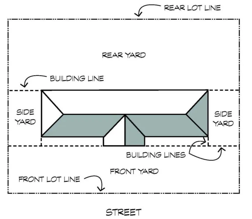 Figure 5-1: Typical Lot Identifying Yard Areas
- Front Yard Setback. The front yard setback is the depth, measured perpendicularly from the nearest point of the front lot line, at the back of the sidewalk, to the nearest part of the main building. Where a PUPF is required, setbacks shall be measured from the back of the curb to the main building.
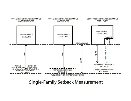
Figure 5-2: Single-Family Setback Measurement
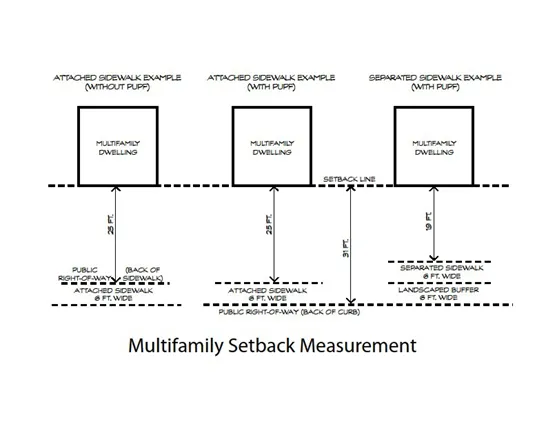
Figure 5-3: Multifamily Setback Measurement
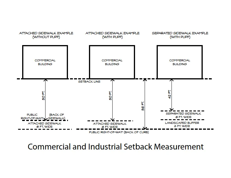
Figure 5-4: Commercial and Industrial Setback Measurement
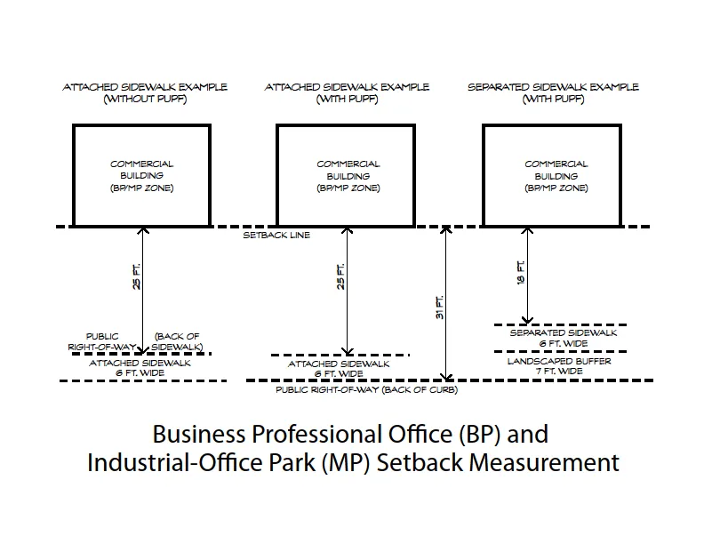
Figure 5-5: Business Professional Office (BP) and Industrial Office Park (MP) Setback Measurement
- Front Yard Setback on a Curved Street. For lots fronting on a curved streets or the curved portion of a cul-de-sac street, the setback is measured along a chord from the center point along an arc coincidental with the edge of the street right-of-way to the nearest part of the main building (as shown in 5-6 figure). Where a PUPF is required, setbacks shall be measured from the back of the curb.
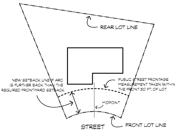
Figure 5-6: Front Yard Setback along a Curved Street
-
Side Yard Setback. The side yard setback is the depth, measured perpendicularly, from the nearest point of the side lot line to the nearest part of the closest building.
-
Corner Street Side Yard Setback. The corner street setback is the depth, measured horizontally, from the nearest part of the closest building to the nearest point of the side lot line at the back of the sidewalk. Where a PUPF is required, setbacks shall be measured from the main building to the street right-of-way line, at the back of curb.
-
Rear Yard Setback. The rear yard setback is the depth, measured perpendicularly from the nearest point of the rear lot line to the nearest part of the main building. For irregularly shaped lots, the rear lot line is defined as the point where the width of the lot is a minimum of 10 feet (as shown in Figure 5-7).
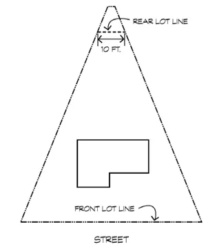 Figure 5-8: Through Lots
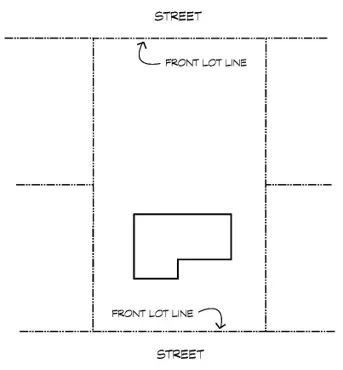 Figure 5-7: Rear Yard Setback for Irregular Shaped Lots
5.2.1.B. Through Lots
Section titled “5.2.1.B. Through Lots”A lot having a frontage on two parallel or approximately parallel streets. In such cases, the property owner may choose which frontage will be used to define the front lot line, and thus the front yard area. The primary buildings and any accessory structures shall be constructed so as not to encroach upon the required yards of any streets. Where a lot has a depth of 125 feet or more, the lot may be treated as two lots with the rear line of each approximately equidistant from the front lot lines (as shown in figure 5-8), provided that all of the yard requirements are met.
5.2.1.C. Use of Setback Areas
Section titled “5.2.1.C. Use of Setback Areas”Except as otherwise permitted in this Code, every part of a required setback shall be open from its lowest point to the sky (refer to Section 5.2.1.D for a description of allowed encroachments into setbacks). For nonresidential development, all setback areas visible from public streets and areas shall be landscaped, as required in Section 5.2.4.
5.2.1.D. Allowed Encroachments in Setbacks
Section titled “5.2.1.D. Allowed Encroachments in Setbacks”Refer to the Development Standards tables, found under the applicable zoning district in this Chapter for allowed encroachments into setback areas. Where not otherwise provided in the Code, the following setback encroachment standards shall apply.
-
Cornices, sills, eaves, canopies, awnings, and similar features may encroach into any required yard area a distance not to exceed 24 inches.
-
Window bays, having a minimum of 50 percent glass, may encroach 24 inches into a required yard area when the finished floor of the window bay is at least 15 inches above the finished floor of the room. The roof overhang above the window bay may not encroach 24 inches into the yard area.
-
Accessory structures must maintain a minimum three foot setback from property lines for any portion of the structure, including the encroachment described by this Section, except for small accessory structures or sheds as noted in Table 5.10
-
Fire escapes, outdoor stairways, balconies, and mechanical equipment shall not encroach more than 36 inches into a yard or court. Ordinary projections of chimneys and flues may be permitted by the Chief Building Official where the same are so placed as not to obstruct the light and ventilation.
-
Except as otherwise restricted in this code, bus shelters may be located within the front or side yard setback of any lot, provided that the shelter complies with Section 3.9.3.N.
-
Lot Area or Setback Reduction for Dedications. Where a lot area or a lot width, depth, or setback has been reduced for an existing legally created lot by not more than 15 percent as a result of acquisition or dedication for an existing or future highway, road, drain, or other public purpose, as a result of a dedication pursuant to a result of a Rezoning, Variance, or Conditional Use Permit, the lot area or yard so reduced may be included in determining compliance with lot area or yard requirements in the same manner as if the acquisition or dedication has not taken place.
-
Lot Area and Width Reduction for Local Public Agency Uses. Contemporaneously with the hearing for a Conditional Use Permit for the establishment of any buildings or grounds owned and operated by a local public agency in any agricultural zoning district, interim agricultural zoning district, or agricultural-residential zoning district, the appropriate authority may permit such uses on a lot of less area or width than required in the zoning district, provided that the area and width of the lot is:
- Adequate for the proposed use and sufficient to provide the required yards, parking areas, and landscaping.
- Adequate under the circumstances of the particular case to prevent the proposed use from being detrimental to the health, safety, peace, morals, comfort, or general welfare of persons residing or working in the neighborhood or to property and improvements in the neighborhood or to the general welfare of the County.
5.2.1.E. Accessibility Accommodations - Federal Fair Housing Amendments Act of 1988 and the California Fair Employment and Housing Act (Reasonable Accommodations)
Section titled “5.2.1.E. Accessibility Accommodations - Federal Fair Housing Amendments Act of 1988 and the California Fair Employment and Housing Act (Reasonable Accommodations)”[AMENDED 09-09-2022]
-
During the building permit review process, staff may approve reduced setbacks for structures relating to disability access (as defined by the Federal Fair Housing Amendments Act of 1988 and the California Fair Employment and Housing Act; referred to as a reasonable accommodation), such as ramps, handrails, or similar as follows:
- Accessibility structures must be clearly labeled as such on building plans.
- Staff may deny or approve modified reduced setbacks if it is determined that the structures can accommodate accessibility needs within or closer to standard requirements.
- In no case shall reduced setbacks result in structures contrary to the public health, safety, or welfare, or be injurious to the property or improvements of adjacent properties.
- In no case shall accessibility related structures encroach onto public utility, road, or other recorded easements.
-
Applicants are not required to provide documentation of disability nor are they required to remove the accessibility structures should an immediate need no longer be present.
5.2.1.F. Building Attachments and Additions
Section titled “5.2.1.F. Building Attachments and Additions”[AMENDED 06-22-2017][AMENDED 05-11- 2018][AMENDED 01-15-2021]
-
Attachments. For a structure to be considered attached to a primary dwelling it must share a wall with the primary dwelling that spans at least 30 percent of the subordinate structure.
-
Additions. For a structure to be considered an addition to a primary dwelling, the structure must meet standard 5.2.1.F.1, above, and the following:
- There must be internal access to the primary dwelling.
- If the addition includes conditioned space, that space must be accessed from conditioned space in the primary dwelling. (I.e., internal access must be from a family room or other living space, rather than a garage.)
- The addition shall not include a kitchen or cooking facilities. (See Section 5.4.5.B for ADU and JADU standards.)
5.2.2. Building Height Standards for All Zoning Districts
Section titled “5.2.2. Building Height Standards for All Zoning Districts”In addition to the height regulations in the Sections and development standard tables that follow, the uses that follow shall also be subject to the height provisions in Sections 5.2.2.A through D. The height provision for buildings or structures shall be interpreted so that both the limitation as to the number of stories and the limitation of the height in feet apply.
5.2.2.A. Height Limits in Aircraft Approach Zoning Districts
Section titled “5.2.2.A. Height Limits in Aircraft Approach Zoning Districts”In any zoning district, no tree or other object of natural growth shall be allowed to grow and no building, appurtenance, tower, or other structure shall be erected or maintained to exceed the height limits developed for aircraft approach and take off areas that are designated on the Comprehensive Zoning Plan that is part of this Code.
5.2.2.B. Height Exceptions for Certain Structures
Section titled “5.2.2.B. Height Exceptions for Certain Structures”[AMENDED 01-12-2019]
Towers, penthouses, and other roof structures for the purpose of shelter for mechanical equipment, solar panels, wind turbines, cupolas, water tanks, church steeples, carillon towers, radio television antennas, and similar structures and necessary mechanical appurtenances may be erected on a building, or on the ground, to a height greater than the limit otherwise established within the zoning district, or for that use, provided that no such exception shall cover at any level more than 15 percent of the area of the lot, nor have an area at the base greater than 1,600 square feet. See Section 3.9.3.B for dish antenna regulations. All construction is subject to approval of the Chief Building Official.
Signs may not be placed on such structures at any height exceeding the height of an otherwise permitted building.
Fences or walls may be required and conditioned to exceed seven feet in height for a project, as determined by the appropriate authority hearing related planning matters on the same parcel of land.
5.2.2.C. Height Exceptions for Buildings in Residential, Commercial, and Industrial Zoning Districts
Section titled “5.2.2.C. Height Exceptions for Buildings in Residential, Commercial, and Industrial Zoning Districts”[AMENDED 09-09-2022]
The Planning Commission may, after reviewing development plans which address 1) glare/reflected heat; 2) energy efficiency; 3) traffic impacts; and 4) effects on adjacent parcels relating to height, scale, and mass of the proposed building; grant a Special Development Permit to allow exceptions to height if the appropriate authority finds that any adverse effects caused by the factors in this paragraph have been adequately mitigated through design features incorporated into the proposed project:
-
All Residential Zoning Districts. Public buildings, hotels, apartment houses, schools, places of worship, hospitals, and other similar buildings may be erected to a height not to exceed 75 feet, provided that the required yards shall be increased one foot for each one foot of height of said building.
-
All Commercial and Industrial Zoning Districts. The number of stories and the height limits for commercial or industrial buildings, hotels and apartment buildings may be increased to a maximum of 150 feet, provided that all buildings are set back from the ultimate right-of-way line of all abutting streets and freeways a distance at least equal to the height of the building. For any residential portion of a hotel or apartment house, all required yards and courts shall be increased one foot for each foot that such building exceeds 40 feet in height. In any case, the floor area to lot area ratio shall not exceed 2.5:1. Commercial buildings located in urban areas may have unlimited height with a Special Development Permit approved by the Planning Commission for projects located within a one-quarter mile of a transit station or stop along a light rail line, bus rapid transit line, or other trunk line providing high frequency bus service with 20 minute or better headways, which is either in existing service, under construction, or planned for service as identified in Regional Transit’s Short-Range Transit Plan Ten Year Capital Program of Projects.
5.2.2.D. Height Criteria
Section titled “5.2.2.D. Height Criteria”In evaluating Special Development Permits for height exception requests, the appropriate authority shall consider the following factors:
-
Use of all contiguous parcels
-
Elevation of the respective parcels
-
The height and number of stories of any structures or buildings on contiguous parcels
-
The beneficial or harmful effect of the height of the building on existing terrain and vegetation
-
The opportunity for a higher structure to overlook yard areas of contiguous parcels and invade the privacy of such yard areas
-
The impact of the proposed structure on traffic circulation
5.2.3. Density Bonuses and Intensity Increases
Section titled “5.2.3. Density Bonuses and Intensity Increases”[AMENDED 09-09-2022]
In addition to the development standards and associated tables for each land use Section in this Chapter, the maximum density and intensity requirements may be increased for the following types of projects as outlined in Table 5.1.
Table 5.1
Section titled “Table 5.1”[AMENDED 07-11-2024]
| Type of Increase | Maximum Increase | Approval Authority | Code Section |
|---|---|---|---|
| Affordable Housing Incentive Program | See Section 6.5.4. | Planning Director unless combined and processed concurrently with discretionary entitlement. | Section 6.5.4. |
| Housing Incentive for Special Needs Groups | 15% | Minor Special Development Permit | Section 6.4.6.G |
| Density Increase for Preservation of Environmentally Sensitive Physical Features | 50% | Special Development Permit approved by the Planning Commission | Section 6.4.6.G |
| Density Increase for Energy Conservation Design | 25% | Special Development Permit approved by the Planning Commission | Section 6.4.6.G. and Section 3.6.6.C. |
| Mobile Home Parks with single-wide mobile homes | 15% | Special Development Permit approved by the Planning Commission | Section 4.5.5.B. |
5.2.4. Landscape Standards
Section titled “5.2.4. Landscape Standards”5.2.4.A. Purpose
Section titled “5.2.4.A. Purpose”Landscape standards in this Section apply to all new development, buildings, or structures that may be erected or enlarged, and/or the maintenance of existing landscaping for all zoning districts in the unincorporated area of the County, unless otherwise noted in this Section. Landscape standards are provided to:
-
Ensure the use of native and/or drought tolerant landscaping which is appropriate to the climate and conditions in the County, provide shade, screen loading and services facilities, help frame views and edges, and provide natural transitions that enhance the quality, walkability, safety and aesthetics of the surrounding built environment;
-
Ensure the healthy establishment and appropriate long-term care and maintenance of all existing and new landscaping provided for all types of development;
-
Promote sustainable landscaping practices that lower urban heat island temperatures, improve air quality, conserve water and energy, restore, and enhance environmentally sensitive areas; and emphasize the use of river friendly landscaping practices and stormwater best management practices.
-
Set provisions for the removal and replacement of unhealthy trees and/or hazardous conditions and proper pruning of trees to remove hazardous obstructions; and
-
Protect the function of trees for shading, carbon and particulate capture, water quality, energy conservation, and aesthetics while ensuring adequate clearance and visibility for safety, lighting of merchant signage, and balancing other needs and functions of the property.
5.2.4.B. Requirements for Institutional, Commercial, Industrial, and Multifamily Residential Use Categories
Section titled “5.2.4.B. Requirements for Institutional, Commercial, Industrial, and Multifamily Residential Use Categories”[AMENDED 09-09-2022]
1. General Requirements
Section titled “1. General Requirements”- Unless otherwise indicated, the minimum container sizes for trees shall be 24-inch box for 35 percent of the trees, and the remainder shall be 15-gallon. The minimum container sizes for shrubs shall be five-gallon for 70 percent of the shrubs, and the remainder shall be one-gallon. The minimum container sizes for groundcovers shall be one-gallon. The required percentages may be considered for adjustment as part of the Design Review process.
- Unless otherwise indicated, tree plantings for all projects shall include 40 percent evergreen species. The required percentage may be considered for adjustment as part of the Design Review process.
- Varied tree and plant species shall be used throughout the site. No one species shall comprise more than 75 percent of trees, shrubs, or groundcovers proposed for the site.
- All landscape and streetscape improvements must meet the County’s Improvement Standards, unless otherwise approved by an adopted streetscape plan, corridor plan, or other special area zoning code; and shall be consistent with the current edition of the County’s Design Guidelines and the following standards.
- Use of irrigation may be waived in the event of mandatory water conservation measures by the water purveyor for the community in which the property is located. Trees and shrubs shall be watered in a manner to keep them alive.
2. Landscaping of Setback and Frontage Areas.
Section titled “2. Landscaping of Setback and Frontage Areas.”All areas between the edge of the street right-of-way and the building or parking lot, and visible from the public street, except for driveways and screen areas, shall be landscaped. See Section 5.2.4.F for parking lot landscaping requirements.
- Frontage Landscaping Adjacent to Parking Lots and Driveways
- A planter at eight feet wide excluding curbing, shall be provided between the edge of parking areas and: 1) sidewalks, where sidewalks are detached from curb and gutter, or 2) street right-of-way where sidewalks are attached. In addition, where the ultimate right-of-way is located behind a public sidewalk or curb, any area within the street right-of-way shall be developed as a planter or landscaped area in conjunction with the required eight foot area in this subsection. The planter shall be designed to comply with parking lot shading and street tree requirements in this Chapter.
- Within this planter, trees approved by the Planning Director shall be planted no further than 30 feet on-center and at least four feet but not further than 10 feet from the back of the sidewalk. The planter shall also include shrubs, ground covers, and other natural growth, or stormwater quality features and drainage treatments. Nothing in this Section shall preclude the installation of additional landscaping and the planting of additional trees so long as it is consistent with the visibility regulations for the County.
- Bus shelters may be located within this planter if approved by the Director of the Department of Transportation or his or her designee and the regional transit agency, but shall not be placed so as to reduce the number of trees which are otherwise required by this Section.
- Frontage Landscaping Adjacent to Buildings. Within the area between the right-of-way and buildings, trees approved by the Planning Director shall be planted no further than 30 feet on-center and at least four feet but not further than 10 feet from the back of the sidewalk. The planter shall also include shrubs, ground covers, and other natural growth, or stormwater quality features and drainage treatments. Nothing in this Section shall preclude the installation of additional landscaping and the planting of additional trees so long as it is consistent with the visibility regulations for the County.
- Landscaped Parkways. When required by the County’s Improvement Standards, a six to eight-foot landscaped parkway shall be provided between the curb (i.e., edge of the street right-of-way) and detached sidewalk.
- Landscape parkways may include earth berms, hedges, fences, or walls, in combination with trees and plantings, and may be used for stormwater purposes.
- Alternative landscaping methods and landscape parkway requirements may be considered as part of the Design Review process.
- Street Trees. Approved trees for planting in County right-of-way and public easements shall be subject to the County’s Improvement Standards. Trees not listed in the Improvement Standards, may be planted with the approval of Planning and Environmental Review for tree selections that can provide the greatest benefits (i.e., benefits to shading, health, air quality, water, and energy conservation) is recommended. The planting of street trees applies to new construction or major reconstruction.
- Clustering and Alternative Design. Alternative design approaches, such as clustering of trees, may also be approved during Design Review.
- Pedestrian Walks and Connections. Required landscape areas should include pedestrian walks and well-marked paths of travel and connections, steps, and similar hard surface areas, provided that such hard surface areas do not cover more than 25 percent of the required landscape areas. A barrier free, four-foot wide paved walk may be provided through the required planter at street and driveway intersections to provide unencumbered access for people with disabilities from the sidewalk to the parking lot. Such walk shall be located so as to facilitate the most direct movement of persons using sidewalk curb ramps, if such are provided.
3. Landscape Screening Along Interior Property Lines.
Section titled “3. Landscape Screening Along Interior Property Lines.”- No landscape planter shall be required for Institutional, Commercial, or Industrial Uses when adjacent to Commercial, Industrial, Institutional or Agricultural uses.
- A minimum seven-foot wide continuous landscaped planter area shall be required for Institutional, Commercial, or Industrial uses when along property lines shared with any Agricultural-Residential or Residential zoning district.
- A minimum seven-foot wide continuous landscaped planter shall be required for Multifamily Residential Uses in all cases.
- Landscaping within this planter shall consist of screen trees approved by Planning and Environmental Review, spaced 30-feet on center, in combination with other plant materials to provide a dense visual screen. Trees shall be planted a minimum of five feet and no further than 10 feet from the required fencing. Fencing requirements for specific uses can be found in Section 5.2.5.
4. Landscape Screening from Public Right-of-Ways and Within Scenic Corridors.
Section titled “4. Landscape Screening from Public Right-of-Ways and Within Scenic Corridors.”- For industrial uses visible from a public right-of-way, not otherwise screened by required landscaping, a 10-foot wide landscaped area shall be provided adjacent to the right-of-way. Landscaping shall include a combination of trees and shrubs at sufficient intervals to achieve the desired screening. Trees shall be planted at least 30 feet on-center. The right-of-way elevation, relative to elevations in the adjoining property, shall be a consideration in selecting landscape plants which can accomplish appropriate visual screening.
- For properties within a scenic corridor, contiguous to a freeway right-of-way, not otherwise screened, a 15-foot wide landscaped area shall be provided adjacent to all freeway rights-of-way in the scenic corridor. Landscaping shall include a combination of trees and shrubs at sufficient intervals to achieve appropriate screening. Trees shall be planted at least 30 feet on-center. The freeway elevation, relative to elevations in the adjoining property, and air quality benefits shall be a consideration in selecting landscape plants which can accomplish appropriate visual screening.
- Shrubs and other natural growth, combined with berms and other landscape features, at least three feet in height, shall be designed to enhance, soften, and visually screen loading and parking areas, trash enclosures, mechanical equipment, walls, and other unsightly uses visible to public right-of-way, except near street and driveway intersections where landscaping shall not exceed 2.5 feet in height in accordance with the visibility regulations of the Sacramento County Improvement Standards. Consideration shall be given to public safety as part of the design and maintenance of these areas.
- A five foot landscape planter shall be installed around the perimeter of trash enclosures if visible from public right-of-way.
5. Landscape Maintenance.
Section titled “5. Landscape Maintenance.”All landscaped areas shall be moved, trimmed, and/or maintained as often as necessary to prevent overgrowth and blight. No junk, debris, or other similar materials may be stored in landscaped areas. Refer to Section 5.2.4.G for additional standards on landscape care and maintenance.
6. Stormwater Quality Landscaping
Section titled “6. Stormwater Quality Landscaping”- On-site stormwater quality landscaping, approved in setback areas or public right-of-way or integrated into the project may count toward required landscaping.
- Pervious pavement and permeable pavers may be a substitute for impermeable hard surfaces but may not substitute for required landscaped planting areas. Ornamental or landscape rock and gravel areas, artificial turf, or areas covered with other artificial materials may be combined with landscape areas, provided that they are approved through the Design Review process.
7. Access for People with Disabilities.
Section titled “7. Access for People with Disabilities.”The design of landscaping shall provide for the access needs, safety, and comfort of persons with disabilities in conformance with the standards of the Americans with Disabilities Act (ADA).
8. Tree Preservation.
Section titled “8. Tree Preservation.”Existing mature and native trees and shrubs shall be preserved and incorporated within the project site design to the extent feasible. Removal of protected trees shall be consistent with the County General Plan, the County Tree Ordinance, Section 5.2.4.H of this Code, and applicable project-specific CEQA mitigation measures.
9. Sustainable Design.
Section titled “9. Sustainable Design.”Landscaping for projects shall be designed to integrate principles of sustainability to the greatest extent feasible. This includes principles of water conservation, the use of trees for energy conservation and to improve air quality, and the use of storm water control features for treatment and run-off reduction, with an emphasis on the use of drought-tolerant and/or native plants. Landscaping plans shall cohesively incorporate the following requirements and guidelines:
- The County of Sacramento Water Efficient Landscape Ordinance.
- The County-Wide Design Guidelines.
- The Sacramento Stormwater Quality Partnerships River-Friendly Landscape Guidelines - Sustainable Practices for the Landscape Professional.
- The Stormwater Quality Design Manual for the Sacramento and South Placer Regions.
- The County of Sacramento Zoning Code, including this Section and the Parking Section 5.2.4.F.
- The integration of these practices shall not compromise requirements for landscaping as established by the Code and the Water Efficient Landscape Ordinance.
10. Irrigation
Section titled “10. Irrigation”- All landscaped areas shall be provided with a permanent or temporary irrigation system, demonstrated on site plans, to ensure the establishment and ongoing maintenance of landscaping. Alternative and innovative methods of irrigation such as use of cisterns for rainwater harvesting and other techniques that recycle water on-site, is encouraged when feasible.
- Drip irrigation systems are recommended for water conservation and run-off reduction for more efficient means of watering trees, shrubs, groundcovers, perennials, and ornamental grasses than a conventional spray system. However, if proper maintenance of drip irrigation systems cannot be provided, a conventional spray or bubbler system is preferred.
- Turf and groundcover areas are more effectively irrigated with efficient, low angle spray heads. Head-to-head spray coverage is recommended. Avoid overspray onto sidewalks and adjacent properties.
- All trees, shrub and groundcover areas, and lawn areas shall be irrigated separately to allow individual control of the irrigation needs for these plant types. Tree irrigation systems shall include bubblers, drip, or similar application, located within a watering basin for each tree.
11. Design Review.
Section titled “11. Design Review.”Preliminary Landscape Plans shall be required and reviewed as part of the Design Review process. For existing buildings and uses, additional landscaping may be required in order to meet the intent of these requirements.
5.2.4.C. Requirements for All Residential Use Categories, Except Multifamily and Mobile Home Parks
Section titled “5.2.4.C. Requirements for All Residential Use Categories, Except Multifamily and Mobile Home Parks”[AMENDED 09-09-2022]
The following landscape requirements address required front and side-street yard areas:
1. Trees.
Section titled “1. Trees.”The developer/home builder shall plant a minimum of one tree in the front yard of every built lot, except as follows:
- For small lot developments, provide one tree per lot in common open space or landscaped areas.
- Should a tree in the front yard interfere with solar panel placement, the tree may be placed in a side or rear yard if sufficient area is available.
- For lots of 7,500 square feet or more that meet or exceed the minimum street frontage requirements measured at the public rights-of-way line, a minimum of two trees shall be planted in the front yard.
- One street tree in planted landscape areas between the curb and sidewalk, in the front yard of the lot, may count toward the minimum street tree requirements for single-family or multifamily housing.
[DELETED 09-09-2022]
3. Required Yard Area Hardscape Restrictions.
Section titled “3. Required Yard Area Hardscape Restrictions.”The maximum amount of paving and hardscape is regulated by Section 5.9.3.C.
4. Landscape and Maintenance Requirements.
Section titled “4. Landscape and Maintenance Requirements.”Notwithstanding 5.9.3.C.a, the remaining unpaved or uncovered portion of the required setback area shall be landscaped, irrigated, and maintained.
- Landscaping may consist of a combination of grass, annuals, perennials, groundcover, shrubs, trees, edible gardens, and any other recognized landscape material as approved by the Planning Director.
- Landscape design elements such as rocks, planters, and mulch may be used, provided that living vegetation is the primary groundcover.
5. Irrigation.
Section titled “5. Irrigation.”An automatic irrigation system shall be installed in the front yard of new construction to provide consistent coverage of all planted areas. A home on a corner lot shall have an automatic irrigation system that covers the yard fronting both streets. Automatic controllers with rain shut-off valves or microclimate sensing capabilities provide greater water conservation.
6. Vehicle Parking Requirements.
Section titled “6. Vehicle Parking Requirements.”Vehicles, including, but not limited to, automobiles, boats, campers, trailers and other recreational vehicles must be parked on a surfaced area in conformance to this Code (See Section 5.9.3.C. for parking standards) and may not be parked within the required landscaped area.
7. Landscape Alternatives.
Section titled “7. Landscape Alternatives.”In the case of a circular driveway that may exceed the maximum hardscape restriction for the yard area, off-setting landscaping may be provided in the area between the required yard area and the dwelling. Other options for landscaping the required yard areas, including the use of additional hardscape materials, artificial turf, or other landscape elements may be approved through the Design Review process.
[DELETED 09-09-2022]
9. Landscaping Adjacent to Soundwalls.
Section titled “9. Landscaping Adjacent to Soundwalls.”- Earthmounds. When the sound and visual attenuation requires a wall exceeding six feet above the grade of the adjacent roadway, earthmounds or terraced landscaping shall be used such that no more than six feet of the wall is visible from the roadway. The mounds shall not exceed a 3:1 slope. The mounds may support the wall or be placed against the wall on the street side. Drainage shall be contained.
- Landscaping. All setback areas shall be landscaped with groundcover, shrubs, vines, mounds and trees such that at least 50 percent of the wall shall be screened from the adjacent public street within five years. Trees shall be placed so as to cover the 50 percent of the total landscaped area with a shade canopy within 15 years of planting. 30 percent of the trees shall be evergreen.
- Maintenance. An automatic sprinkler system shall be installed and a maintenance program shall be established to provide ongoing maintenance of the wall and landscaped area. The proposed maintenance program shall be submitted with the application and may consist of one, or a combination, of the following:
- A homeowners association agreement;
- An assessment district, Lighting and Landscape Act District, or similar district;
- Other viable alternative presented in public hearing and found acceptable to the appropriate authority. The proposed maintenance program shall be submitted with the application.
5.2.4.D. Additional Requirements for Industrial Zoning Districts
Section titled “5.2.4.D. Additional Requirements for Industrial Zoning Districts”[DELETED/STANDARDS CONSOLIDATED IN SECTION 5.2.4.B.4]
5.2.4.E. Additional Requirements for Commercial Zoning Districts
Section titled “5.2.4.E. Additional Requirements for Commercial Zoning Districts”[DELETED/STANDARDS CONSOLIDATED IN SECTION 5.2.4.B.4]
5.2.4.F. Parking Lot Landscaping
Section titled “5.2.4.F. Parking Lot Landscaping”[AMENDED 07-16-2020] [AMENDED 09-09-2022]
The landscape construction standards of Table 5.2 apply to parking lot areas in all zoning districts.
Table 5.2 Parking Lot Landscaping Construction Standards [1]
Section titled “Table 5.2 Parking Lot Landscaping Construction Standards [1]”| Standard | Minimum Requirement |
|---|---|
| Interior Planter Requirements - General |
|
| Interior Planter Requirements - Additional for Multifamily Residential and Mixed-Use Developments |
|
| Curbing | All landscaping shall be within planters bound by a curb at least six inches high. Curbs separating stormwater management landscaping or other landscaped area intended to filter runoff, from parking areas, shall provide curb cuts to allow stormwater run-off. |
| Irrigation System | Required, unless otherwise permitted in Section 5.2.4.B.9. |
| Hardscape | Not more than 25 percent of the parking landscaped area may be covered with gravel, landscaping rock, or concrete or other impervious materials. |
| Shading - Location | Shade trees shall be placed within perimeter and interior landscape planters. |
| Shading - Amount [2] | 50% |
| Shading - Tree Selection | Tree selection, planting approach, and irrigation shall be designed to provide for the rapid growth and sustained health of shade trees and shall comply with the County’s water efficient landscape ordinance. Small ornamental trees are appropriate for accent planting but shall not be used to meet shading requirements. |
| Alternative Standards for “Carport” Type Accessory Solar Facilities | Alternatives to these standards for new parking lots, where ground mounted “carport” type accessory solar facilities are utilized, may be considered through the Design Review process. |
[1] Applicable to all use types in all zoning districts where there are more than five parking spaces on the entire site, except for existing parking lots where compliance with interior landscaping standards would result in the loss of existing required parking spaces.
[2] Shaded area calculated as total parking area (excluding drive aisles) covered with tree canopy within 15 years of securing a building permit.
5.2.4.G. Landscape Care and Maintenance
Section titled “5.2.4.G. Landscape Care and Maintenance”[AMENDED 04-07-2016]
This Section addresses the appropriate long-term care and maintenance of all landscaping provided for commercial, multifamily, industrial, and institutional developments. It is also intended to set provisions for the removal and replacement of unhealthy trees and or hazardous conditions and provide adequate clearance and visibility of merchant signage, when the aesthetics of the tree and shading requirements will not be reduced.
1. Care and Maintenance
Section titled “1. Care and Maintenance”- All required landscaping and irrigation shall be maintained for the life span of the project and in such a manner so as to not create hiding places or hinder visibility.
- All plant materials (trees, shrubs, and groundcovers) shall be maintained free from physical damage or injury arising from vehicle encroachment, lack of water, weather events, chemical damage, insects and other pests, and diseases. Plant materials showing such damage shall be replaced with the same or similar species. Planting areas shall be kept free from weeds, debris, and undesirable materials which may be detrimental to safety, drainage, or appearance.
- It is the responsibility of the property owners to seek professional advice and spray and treat trees, shrubs, and groundcover for diseases which can be successfully controlled if such untreated diseases are capable of destroying an infected tree or other trees within a project.
- Property owners may refer to the integrated pest management strategies in the Sacramento Stormwater Quality Partnership’s River-friendly Landscape Guidelines and can cooperate with the University of California Agricultural Extension Service and the County Agricultural Commission on methods and procedures by which infestations can be reduced or retarded.
2. Tree Pruning
Section titled “2. Tree Pruning”- Prior to pruning, trenching, or grading within the drip line of any required tree, a County Tree Pruning Permit shall be approved by the Planning Director or his or her designee, and the County Tree Coordinator. Tree Pruning shall be performed by a person certified by the International Society of Arboriculture (ISA) as a Certified Tree Worker or Certified Arborist or by the American Society of Consulting Arborists as a Registered Consulting Arborist. A Tree Pruning Permit is issued for one or more trees at a single site and is valid for one year, and can be amended or extended by the Tree Coordinator. The Planning Director or his or her designee shall require the following information upon submitting the Tree Pruning Permit request:
- A site plan indicating the type of tree, size, and location of the trees to be pruned;
- Reasons for pruning;
- Evidence that the pruning shall be performed by an ISA Certified Arborist, ISA Certified Tree Worker, or Registered Consulting Arborist.
- Number of trees to be pruned.
- Tree pruning shall be consistent with the most recent American National Standards Institute (ANSI) Pruning Standards and is limited to any of the following:
- Removal of dead wood and diseased, crowded, and weakly attached branches which create a hazard to private property and citizens;
- Providing adequate clearance and visibility for safe use of parking stalls, travel ways, and walkways for the passage of persons and vehicles;
- Removing visibility obstructions to traffic signs;
- Providing adequate visibility for security patrols;
- Repair of split trees and limbs in order to save the tree and its appearance;
- Removing or pruning roots of trees which are causing damage to public or private property such as curbs, gutters, sidewalk, drainage lines, and parking lot surfaces;
- Providing visibility for merchant signage and parking lot lighting only when the natural growth form of the tree is retained and the parking lot shading requirements will not be reduced.
- Tree pruning is exempt from Zoning Code requirements for a Tree Pruning Permit if it is consistent with the specifications in Section 5.2.4.G.2., and meets all of the following requirements:
- Less than 15 percent of the canopy of the tree is removed per year; and
- The diameter of the tree’s roots and branches being pruned are less than one quarter of the diameter of the tree’s trunk measured at 4.5 feet off the ground. For example, a permit would not be required to prune limbs less than one inch diameter for a tree with four inch trunk diameter; and
- The tree’s roots and branches being pruned are less than two inches diameter, and
- No heading, topping, or hat-racking shall occur.
- Pruning native oaks is subject to Title 19 of the SCC. This includes valley oak (Quercus lobata), interior live oak (Quercus wislizeni), blue oak (Quercus douglasii), or oracle oak (Quercus morehus).
5.2.4.H. Removal and Replacement of Landscaping
Section titled “5.2.4.H. Removal and Replacement of Landscaping”[AMENDED 04-07-2016]
-
All required plant material removed shall be replaced with the following replacement sizes: shrubs (five-gallon size), groundcover (flats). Replacement of trees shall be as specified in Section 5.2.4.I.
-
Tree removal shall be limited to trees which are in poor health, structurally distressed, or imminently hazardous to persons or property and shall be in compliance with the regulations and procedures for tree preservation and protection in Title 19 of the SCC. The removal of a tree shall be the final recourse upon determining that it is infeasible to save the tree by any other method (e.g., pruning, treatment of diseases, fertilizing). Prior to the removal of any tree, a Tree Removal Permit shall be approved by the Planning Director and the County Tree Coordinator or his/her designee.
-
The following information shall be required:
- A statement of the health and condition of the trees to be removed by a Certified Arborist or licensed Landscape Architect;
- Reasons for removal; and
- Landscape Plan indicating size, quantity, species, and location of the trees to be removed and replaced.
-
Failure to obtain an approved tree removal permit prior to removing a tree shall require the owner of the project to replace the removed tree as stated in the Replanting Requirements in Section 5.2.4.I.
5.2.4.I. Replanting Requirements and Replacement Fee
Section titled “5.2.4.I. Replanting Requirements and Replacement Fee”[AMENDED 07-16-2020]
Replacement trees shall be required for trees removed with or without a Tree Removal Permit, as set forth below.
-
Trees removed with a Tree Removal Permit shall be replaced by 24-inch box specimen trees. A 15-gallon size tree may be used as a replacement tree with an additional replacement fee. The replacement fee is based on the difference of the wholesale value between a 24-inch box and a 15-gallon tree as set forth in a fee schedule approved by the Board of Supervisors. The replacement fee may be waived by the Planning Director if the loss of the tree resulted from causes completely out of the control of the property owner.
-
Trees removed without a Tree Removal Permit or severely and improperly trimmed with or without a Tree Pruning Permit shall be replaced and a replacement fee may be required. The replacement tree is based according to the size of the tree removed or damaged as indicated in Table 5.3.
Table 5.3 Size of Required Replacement Trees
Section titled “Table 5.3 Size of Required Replacement Trees”Size of Damaged / Removed Trees Replacement Tree Required 2 inches 24-inch box 4 inches 36-inch box 6 inches or greater 48-inch box -
A 15-gallon size tree may be used as a replacement with an additional replacement fee, as set forth in a fee schedule approved by the Board of Supervisors. Replacement fees shall be deposited into a Parking Lot Shade Tree Violation account. Fees shall be used for tree planting/tree care on public property and for public education on tree planting and care, as determined by the Board of Supervisors.
-
Mitigation Monitoring and Reporting Program (MMRP). Prior to accepting an application for tree removal or pruning, the County Tree Coordinator, or his or her designee shall determine if there is an active MMRP that affects the proposal. If there is an active MMRP, an application will not be required and the applicant is to be referred to the County Division of Planning and Environmental Review.
5.2.5. Development Standards for Walls and Fences
Section titled “5.2.5. Development Standards for Walls and Fences”All proposed walls and fences shall comply with the requirements of this section.
5.2.5.A. General Standards
Section titled “5.2.5.A. General Standards”[AMENDED 06-07-2018]
-
All Fences Adjacent to Drives and Street Intersections. When fences, walls, and/or landscape screening are adjacent to street intersections and points of ingress and egress the visibility requirements of the Sacramento County Improvement Standards shall be adhered to. Application of CPTED strategies shall be considered in the design of these features.
-
Perimeter Fences for Swimming Pools. Perimeter fences shall be required around private pools, not otherwise restricted from unauthorized access from the public, subject to the construction requirements contained in the California Building Code Section 3109.4.4.3.
-
Masonry Walls. A graffiti-resistant aesthetic surface treatment, appropriate to the location, shall be required. Long spans of masonry walls or fences shall provide breaks for pedestrian connections at least every 300 feet. Application of CPTED strategies shall be considered in the design of these features.
-
Freeway Fences. Solid fences to screen freeways and any required maintenance shall be the responsibility of the property owner in which the fence is located.
-
Vacant Property. A Temporary Use Permit is required from the Zoning Administrator for security fencing, including chain link, which may be erected on all property lines and to the edge of the sidewalk. The vacant property shall be maintained in a weed and litter free condition.
-
Permitted Materials. A fence may be constructed of permanent material, such as wood, chain link, stone, rock, concrete block, masonry brick, brick, decorative wrought iron or other material approved by the Planning Director.
-
Prohibited Materials. Fencing materials prohibited include, but are not limited to, the following. This Section shall only apply to fences located in the front yard, street side yard, and fences abutting any alley or other public right-of-way.
- Cast-off, secondhand, or other items not originally intended to be used for constructing or maintaining a fence.
- Plywood less than five-eighths inches thick, plywood not of a grade approved the Planning Director, particle board, paper, and visqueen plastic, plastic tarp, cloth, or similar material.
-
The use of barbed wire, concertina wire or electric fencing shall require a Minor Use Permit, unless such fencing is located in the Agricultural, M-1, or M-2 zoning districts, and located adjacent to property in either the agricultural or industrial zoning district, in which case its use shall be permitted, subject to the standards set forth in Section 3.9.3.X. The use of barbed wire and electric fencing is permitted in the AR-2, AR-5 and AR-10 zones if used for the keeping of animals.
-
Maintenance. All fences shall be properly maintained so as not to create a hazard, public nuisance, or blight.
-
Exceptions. Fences deviating from the standards in this Section are permitted with a Special Development Permit approved by the Zoning Administrator. Fence standards may be modified by a condition of approval by the appropriate authority as part of a separate entitlement.
5.2.5.B. Measuring Height.
Section titled “5.2.5.B. Measuring Height.”Fence height for fences within five feet of a public right-of-way or right-of-way with PUPF shall be measured from the grade of the right-of-way or right-of-way with PUPF. Beyond five feet, fence height shall be measured from highest elevation of the ground on either side of the fence.
Single Family Residential and Duplex Fences.
Section titled “Single Family Residential and Duplex Fences.”[AMENDED 06-07-2018][AMENDED 01-12-2019]
The following text is erroneously not assigned it’s own subsection. All sections herein are a part of Section 5.2.5.B until the Code is amended.
1. Front Yards in All Zones Except AR and AG Zones.
Section titled “1. Front Yards in All Zones Except AR and AG Zones.”- Fences in the front yard setback area shall be limited to:
- Solid walls or fences as defined in Chapter 7 not exceeding three feet in height,
- Semi-open fencing, such as picket fencing, not exceeding four feet in height,
- Open fencing constructed of chain link or similar woven wire materials, or expanded metal fencing not exceeding four feet in height,
- Open fencing constructed of wrought iron or similar material not exceeding seven feet in height, or
- Open fencing (other than chain link) over a solid fence, when the solid portion of the fence does not exceed three feet in height and the overall height does not exceed seven feet in height.
- Fencing exceeding height limits up to seven feet. Fences exceeding the heights described in i-iii of this section, up to seven feet, may be allowed with the issuance of a Minor Use Permit subject to the General Findings described in Section 6.4.2.C.2. In addition, the approving authority shall determine one of the following:
- For solid fence over three feet in height there shall be a preponderance of solid fencing over three feet in the neighborhood and/or the fence is located along an arterial or thoroughfare.
- For fences constructed of chain link or similar woven wire material or semi-open fencing exceeding four feet in height there shall be a preponderance of chain link or similar woven wire material or semi-open fencing over four feet in the neighborhood and/or the fence in located along an arterial or thoroughfare.
- The fence height provisions of 5.2.5.B.1.a.(i)-(v) shall apply in the required front yard setback areas.
- For lots on a curved street or curved portion of a cul-de-sac, refer to Section 5.2.1.A.2. to determine front yard setback areas for fences. Existing primary dwelling setbacks do not override the setback requirements for fences established in this Section.
- For lots without public street frontage, front yard setback areas, where fence height restrictions apply, shall be determined pursuant to Figure 5-10.
2. Front Yards in AG and AR Zones.
Section titled “2. Front Yards in AG and AR Zones.”The maximum height is seven feet for open or solid fencing.
3. Side Street Yards.
Section titled “3. Side Street Yards.”Fences shall not exceed seven feet in height. Retaining wall and fence combinations that exceed seven feet in height may be permitted with the issuance of a Minor Use Permit. Fence height for fences within five feet of a public right-of-way or right-of-way with PUPF shall be measured from the grade of the right-of-way or right-of-way with PUPF. Beyond five feet, fence height shall be measured from highest elevation of the ground on either side of the fence.
4. Interior Yards in All Zones.
Section titled “4. Interior Yards in All Zones.”Fences shall not exceed seven feet, unless otherwise noted in Section 5.2.5.B.6., and may be located on a retaining wall not to exceed four feet in height. Fence height for interior property lines shall be measured from the highest elevation at the interior property line or at the finished grade of the rear or side yard setback, whichever is higher.
5. Corner Lot Exceptions to yard locations.
Section titled “5. Corner Lot Exceptions to yard locations.”Regardless of which street frontage of the lot determines where the front lot line is, as defined in Chapter 7, Section 3, for purposes of measuring fence height, the frontage with the primary entrance to the main dwelling shall be considered the front yard and the other frontage(s) shall be considered the side street yard(s). In the case of a corner lot with a duplex, or two or more dwellings, where primary entrances face both frontages, both frontages shall be considered the front yard. Where a home demonstrates multiple established primary entrances on both frontages, both frontages shall be considered the front yard.
Fences over seven feet in height are permitted when setback three feet from an interior property line after first securing an approved building permit. Fences over seven feet in height may be permitted on interior property lines with a Special Development Permit approved by the Zoning Administrator. Fence height may be modified by a condition of approval where the Zoning Administrator finds that due to site features different screening requirements are necessary.
5.2.5.C. Multifamily and Institutional Use Fences
Section titled “5.2.5.C. Multifamily and Institutional Use Fences”-
Front and Side Street Yards.
- Multifamily Uses. Only open ornamental security fences may be located directly outside and adjacent to the back of the sidewalk. All other fences along a public right-of-way in the multifamily zoning district shall be subject to the requirements for sound walls in Section 5.2.5.E.
- Institutional Uses. Fences are not permitted, except that open ornamental fences such as wrought iron are permitted on the property line along a public right-of-way. Any fence located along a public right-of-way shall be placed behind sidewalks and required landscaping.
-
Adjacent to Residential and Agricultural-Residential Zoning Districts. Either a solid wood fence or masonry wall of at least six feet in height shall be provided along the interior property lines when located adjacent to residential and agricultural-residential zoning districts, except where pedestrian connections are need.
5.2.5.D. Commercial and Industrial Fences
Section titled “5.2.5.D. Commercial and Industrial Fences”-
Front and Side Street Yards. Fences are not permitted, except that open ornamental fences such as wrought iron are permitted on the property line along a public right-of-way. Any fence located along a public right-of-way shall be placed behind sidewalks and required landscaping.
-
Adjacent to Residential and Agricultural-Residential Zoning Districts. A masonry wall of at least six feet in height shall be provided along the interior property lines for all industrial, commercial, and mixed-use projects when located adjacent to residential and agricultural-residential zoning districts, except where pedestrian connections are needed.
-
No fencing requirements for interior yards for commercial and industrial uses not located adjacent to Residential and Agricultural-Residential Zoning Districts.
-
Fencing in the M-1 and M-2 zones may have an additional three feet of wire fencing placed on top of a fence to a maximum overall height of nine feet. This is not permitted within the front and side street yards.
-
Screen Fences
- Outdoor storage of materials and equipment shall be located within the buildable portion of the lot, and screened from view with solid wood fencing, a masonry wall, or chain-link fencing with slats. Screen fencing shall also be located within the buildable portion of the lot, unless otherwise noted in this Code.
- Outdoor storage areas, abutting a public street frontage, shall be screened with a six-foot high fence, constructed of wood, brick, rock, or other masonry material and designed to shield stored materials from public view. Outdoor storage yards along a scenic corridor shall not be permitted, unless a Conditional Use Permit is issued by the appropriate authority.
- All company vehicles in the MP zone shall be located within the buildable portion of the lot and screened from view with fences, constructed of wood, brick, rock, or other masonry material.
- In the M-1 and M-2 zones, company vehicles, less than one ton, do not require screening and may be parked behind the required landscape area with or without security fencing, as set forth in this Section. Company vehicles, exceeding one ton that are permitted on the public highways and used in the daily operation of the company may be parked within the buildable portion of the lot without screen fencing.
5.2.5.E. Sound Walls Adjacent to Streets
Section titled “5.2.5.E. Sound Walls Adjacent to Streets”- Whenever sound walls are required by a condition of approval to mitigate sound impacts adjacent to street, the following standards shall apply. These standards shall not preclude the use of other innovative methods of project design, utilizing greater setbacks, building design, mounding, terracing, or single-story structures. Application of CPTED strategies shall be considered in the design of these features.
- Setbacks. Walls shall be located behind the sidewalk and required landscaping, unless otherwise approved, and have an average setback of 19 feet from the ultimate public street right-of-way, but can vary in setback to a minimum of 13 feet.
- Height. Maximum height of a wall shall not exceed six feet above the finished grade at the base of the wall on the roadway side, with the exception for earthmounds as described in Section 5.2.4.C.9, unless otherwise approved through a Use Permit, as described in this Section.
- Type of Wall. Walls shall be constructed of graffiti resistant solid brick or masonry material that requires minimum maintenance and provides the required sound and visual attenuation. An aesthetic surface treatment appropriate to the location shall be required.
- Landscaping. Provide landscaping and maintenance per Section 5.2.4.C.9.
5.2.5.F. Nonconforming Fences
Section titled “5.2.5.F. Nonconforming Fences”-
Continuation and Maintenance. A non-conforming fence may be continued, and may be maintained, except as provided in Sections 5.2.5.F.2 – 5.
-
Maintenance or Repair of Existing Nonconforming Fence. Maintenance or repair, including structural repairs, may be made to any non-conforming fence or portions thereof if the repairs do not result in a different condition of conformity, or if the repairs bring the fence into compliance with this Section.
-
Reconstruction of Damaged Nonconforming Fences. A property owner may reconstruct a non-conforming fence damaged by fire or other calamity if the reconstructed fence is in conformity with this Section.
-
Removal of Worn Nonconforming Fence. If because of normal wear and tear a non-conforming fence is no longer fully upright or is no longer serviceable, the property owner either shall remove it or shall replace it with a new fence in conformity with this Chapter.
-
Non-conforming Commercial or Industrial Fences Adjacent to Residential and Agricultural-Residential Zoning Districts. In addition to Sections 5.2.5.F.1 through 5.2.5.F.4, existing wood fences and chain link fences with slats shall be maintained with metal posts, minimal gaps, no broken boards and no sections that lean. Non-conforming fencing shall be the responsibility of the commercial or industrial property owner where the fence is located and activities on the premises shall comply with the County’s Noise Ordinance.
5.2.6. Freestanding Flag Poles
Section titled “5.2.6. Freestanding Flag Poles”[ADDED 07-16-2020]
5.2.6.A.
Section titled “5.2.6.A.”In agricultural, agricultural-residential, residential and recreational zoning districts, new freestanding flag poles shall be located outside of all easements and ROWs and be subject to the height and setback requirements for residential accessory structures found in Table 5.10 except that encroachment of up to 10 feet is allowed into front yard setbacks.
5.2.6.B.
Section titled “5.2.6.B.”In mixed use, commercial and industrial zoning districts, new freestanding flag poles shall be located outside of all easements and ROWs and be subject to the standard height and setback requirements of the applicable zoning district.
5.3. AGRICULTURAL, AGRICULTURAL-RESIDENTIAL, AND RECREATIONAL ZONING DISTRICTS
Section titled “5.3. AGRICULTURAL, AGRICULTURAL-RESIDENTIAL, AND RECREATIONAL ZONING DISTRICTS”[AMENDED 05-11-2018][AMENDED 07-16-2020]
This Section provides:
- Standards for lots in the Agricultural, Agricultural-Residential, and Recreational zoning districts,
- Development standards for general agricultural structures in all zoning districts, where permitted, and
- Development standards for incidental agricultural accessory structures in Agricultural and Agricultural-Residential zoning districts.
Alternatives to these standards may be approved with a Special Development Permit if the intent and purpose of the standards and guidelines are met. Refer to Section 3.4. for applicable special use regulations.
5.3.1. Development Standards for Agricultural Uses
Section titled “5.3.1. Development Standards for Agricultural Uses”5.3.1.A. Lot Standards Summary
Section titled “5.3.1.A. Lot Standards Summary”Table 5.4 Agricultural, Agricultural-Residential, and Recreational Zoning Districts
Section titled “Table 5.4 Agricultural, Agricultural-Residential, and Recreational Zoning Districts”| Minimum Standard | AG-160 | AG-80 | AG-40 | AG-20 | UR | IR | RR | O | AR-10 | AR-5 | AR-2 | AR-1 |
|---|---|---|---|---|---|---|---|---|---|---|---|---|
| Lot Area (gross acres, unless otherwise specified) | 160 | 80 | 40 | 20 | 20 | 20 | 20 (net) | 3 (net) | 10 | 5 | 2 | 1 [1] |
| Lot Width (feet) | 1,000 | 1,000 | 500 | 500 | 500 | 250 | 300 | 200 | 300 | 250 | 150 | 75 |
| Street Frontage (feet) [2] | N/A | N/A | N/A | N/A | N/A | N/A | N/A | N/A | 300 | 250 | 150 | 75 |
[1] Subdivision projects shall be required to have public water.
[2] Up to four lots may be served by a private drive without meeting the street frontage requirement.
5.3.1.B. Lot Size Reductions – Agricultural Zoning Districts
Section titled “5.3.1.B. Lot Size Reductions – Agricultural Zoning Districts”-
Parcels may be created smaller than the lot area specified for the following uses: agricultural processing; agricultural organizations; agricultural sales; agricultural warehousing; agricultural specialty services; animal feed lot/sales; agricultural equipment repairs, maintenance; kill floors; hospitals; cemetery; commercial riding stables, boarding stables and riding academies; private social center; lodge, fraternal hall; animal hospital and veterinarian office; kennel/cattery; places of worship; public or private school, college, or university; child day care center; residential care home for more than six children or adults; public and government buildings or uses; airport; public utilities and public service facilities; outdoor recreation uses; fraternity/sorority house and similar and like uses subject to the approval of a Conditional Use Permit and Design Review. These uses shall also be subject to the following standards:
- Lot area and width shall be the minimum required for the operation of the proposed use and its necessary infrastructure and still comply with all applicable setback requirements of this Section. Final determination of the minimum area and width necessary for any proposed use above shall rest with the administrative hearing body empowered to grant such requests. For any parcel encumbered by the Williamson Act Contract, said lot area shall also comply with the provisions of CA GOV §66474.4.
- As a condition of approval of the reduction in lot area for any of the proposed uses above, the owner or owners of the property shall convey to the County the right to develop or construct principal residences on the lot created and on the remainder of the property in order to guarantee that the reduction in the lot area will not result in an increase in the density of residential uses than otherwise permitted in the zoning district in which the property is located.
-
All other alternatives to lot size standards may be approved with a Special Development Permit if the intent and purpose of the standards and guidelines are met.
5.3.2. Agricultural Structures in Agricultural and Agricultural-Residential Zoning Districts
Section titled “5.3.2. Agricultural Structures in Agricultural and Agricultural-Residential Zoning Districts”5.3.2.A. Applicability
Section titled “5.3.2.A. Applicability”-
For General Agricultural Structures, such as paddocks, barns, and commercial stables used for General Agricultural Uses as defined, use the Development Standards in Table 5.5.
-
For Incidental Agricultural Accessory Structures related to incidental keeping of animals, or incidental agricultural uses in the Agricultural or Agricultural-Residential zoning districts use the Development Standards in Table 5.6. See Section 5.4.5., Table 5.10 for development standards in Residential zoning districts.
5.3.2.B. Development Standards for General Agricultural Structures
Section titled “5.3.2.B. Development Standards for General Agricultural Structures”The following development standards in Table 5.5 apply to General Agricultural structures and commercial stables in all zones where permitted.
Table 5.5 Development Standards for General Agricultural Structures
Section titled “Table 5.5 Development Standards for General Agricultural Structures”| Development Standard | Requirement |
|---|---|
| Minimum Front Yard Setback | 50 ft (Without PUPF) / 55 ft (with PUPF) |
| Minimum Interior Yard Setback | 50 ft [1] |
| Minimum Rear Yard Setback | 50 ft (Without PUPF) / 55 ft (with PUPF) |
| Maximum Height to Peak (Height Limit) [2] | 50 ft |
PUPF = Public Utilities, Public Facilities easement (per Section 5.2.1)
[1] Deviations from setbacks are permitted with a Minor Use Permit.
[2] Water tanks, silos, granaries, barns, antennas, and similar accessory or necessary mechanical structures may exceed a height of 50 feet provided they do not exceed any other height restrictions imposed on the specific location of the structure.
5.3.2.C. Development Standards for Incidental Agricultural Accessory Structures in Agricultural and Agricultural-Residential Zoning Districts
Section titled “5.3.2.C. Development Standards for Incidental Agricultural Accessory Structures in Agricultural and Agricultural-Residential Zoning Districts”The following development standards in Table 5.6 apply to Incidental Agricultural Accessory Structures in the Agricultural and Agricultural-Residential zoning districts, constructed, enlarged, or otherwise modified.
Table 5.6 Development Standards for Incidental Agricultural Accessory Structures in Agricultural and Agricultural-Residential Zoning Districts
Section titled “Table 5.6 Development Standards for Incidental Agricultural Accessory Structures in Agricultural and Agricultural-Residential Zoning Districts”[AMENDED 12-01-2017][AMENDED 05-11-2018]
| Required Development Standard | Maximum of 50% of the Habitable Floor Area of the Primary Dwelling [1][2][3] | Maximum of 100% of the Habitable Floor Area of the Primary Dwelling [1][2] | Maximum of 200% of the Habitable Floor Area of the Primary Dwelling [1][2] |
|---|---|---|---|
| Net Lot Area | Less than 1 Acre | 1-2 Acres | Over 2 Acres |
| Minimum Front Yard Setback | 25 ft (Without PUPF) / 30 ft (With PUPF) | 20 ft (Without PUPF) / 25 ft (With PUPF) | 20 ft (Without PUPF) / 25 ft (With PUPF) |
| Minimum Interior Side Yard Setback | 10 ft | 10 ft | 10 ft |
| Minimum Rear Yard Setback | 10 ft | 20 ft | 20 ft |
| Minimum Side Street Yard Setback | 12.5 ft (With PUPF) / 18 ft (Without PUPF) | 12.5 ft (With PUPF) / 18 ft (Without PUPF) | 12.5 ft (With PUPF) / 18 ft (Without PUPF) |
| Maximum Height of Structure to the Peak of the Roof | 24 ft | Same as permitted for primary dwelling | Same as permitted for primary dwelling |
PUPF = Public Utilities, Public Facilities easement (per Section 5.2.1)
[1] The total floor area for all Incidental Agricultural Accessory Structures and general Accessory Structures combined in Agricultural and Agricultural-Residential zoning districts shall not exceed 5,000 square feet. Exceptions to these area requirements may be permitted with a Minor Use Permit.
[2] Exceptions to these area requirements may be permitted with a Minor Use Permit.
[3] The size of accessory structures on legal nonconforming parcels less than one acre in size may be increased to greater than 50 percent with a Minor Use Permit.
5.3.3. Development Standards for Accessory Dwellings for Agricultural Employees
Section titled “5.3.3. Development Standards for Accessory Dwellings for Agricultural Employees”The following standards shall be met:
5.3.3.A.
Section titled “5.3.3.A.”Income requirements as listed in Section 3.9.3.C.
5.3.3.B.
Section titled “5.3.3.B.”For each lot, a minimum gross area of five acres per agricultural accessory dwelling unit is permitted.
5.3.3.C.
Section titled “5.3.3.C.”The agricultural accessory dwelling setbacks and height shall meet the setbacks and height required for the primary dwelling.
5.3.3.D.
Section titled “5.3.3.D.”For accessory dwelling units not related to agricultural employees, refer to Section 5.4.5.F.
5.3.3.E.
Section titled “5.3.3.E.”For farmworker housing, see Section 3.5.2.B.
5.4. RESIDENTIAL ZONING DISTRICTS
Section titled “5.4. RESIDENTIAL ZONING DISTRICTS”5.4.1. Purpose
Section titled “5.4.1. Purpose”[AMENDED 09-09-2022]
This Section provides the development standards regulating all types of residential development, including single-family residential development, multifamily residential development, mobilehome subdivisions, and accessory structures. The Residential Standards consist of five sections, including:
- Section 5.4.1: Purpose;
- Section 5.4.2: Low Density Residential Development Standards;
- Section 5.4.3: High Density Residential Development Standards;
- Section 5.4.4: Mobilehome Subdivision Development Standards; and
- Section 5.4.5: Accessory Structure and Accessory Dwelling Unit Development Standards
Residential standards in this Section are provided to facilitate project review and help applicants and County staff to identify major design issues and devise solutions early in the application process, reducing the need for special exceptions that require elaborate discretionary project approvals. The standards are updated to account for a variety of residential prototypes, yet establish a process that allows flexibility within the intent of these standards and encourages creative and innovative development solutions, with the final determination of acceptability and appropriateness made by the County based on the review of each project proposal through the Design Review process, described in Section 6.3.2. Applicants should consult with County staff in the early stages of the project design.
The purpose of this Section is to work with the County, community members, and developers to raise the overall design quality of residential developments occurring in the County. Application of these principles will result in high quality residential developments that are varied and integrated into the existing built surroundings and character of their respective neighborhood communities. The residential standards are provided to:
-
Promote compatibility and connectivity between new and existing development;
-
Maintain and enhance the community’s identity, health, safety, and quality of life;
-
Encourage high-quality development;
-
Integrate physical activity and the use of sustainable strategies in designing the built environment when addressing site design, building design, and landscaping;
-
Integrate active transportation, safe routes to schools, and parks strategies;
-
Facilitate a clear and efficient project review process; and
-
Maintain the health, safety, and welfare of all citizens of the County.
5.4.2. Low Density Residential Development Standards
Section titled “5.4.2. Low Density Residential Development Standards”[AMENDED 07-16-2020][AMENDED 09-09-2022]
5.4.2.A. Applicability
Section titled “5.4.2.A. Applicability”[AMENDED 09-09-2022]
-
The standards of Section 5.4.2.B apply to:
- Lots created for Single-Family Attached or Detached, Duplex/Halfplex residential in all zoning districts, where allowed.
- All Single-Family Attached or Detached and Duplex/Halfplex subdivisions.
- See Section 5.4.3.B for lots created for Multifamily Residential projects in all zoning districts, where allowed.
-
The standards of Section 5.4.2.C apply to:
- Projects for Single-Family Attached or Detached, Duplex/Halfplex, Family Daycare Home, and Residential Care Homes in all zones where permitted but not governed by other specific plan, special planning area, or neighborhood preservation area standards. This shall include all new construction, retrofitting, and remodeling of existing construction of the above.
- See Section 5.4.3.C for Multifamily Residential project standards in all zones where allowed.
- The development standards in this Section are to be used in close concert with the County-Wide Design Guidelines to achieve high quality projects that fit within the surrounding community. Design Review, however, may not apply in all cases.
5.4.2.B. Lot and Subdivision Standards – Low Density Residential
Section titled “5.4.2.B. Lot and Subdivision Standards – Low Density Residential”[AMENDED 09-09-2022]
-
Densities allowed in the RD-1 through RD-10 zones are listed in Table 5.7.A.
-
Lots created for Single-Family Attached or Detached and Duplex/Halfplex residential in all zoning districts, where allowed, shall be subject to the standards of Table 5.7.A.
-
Subdivisions for new Single-Family or Duplex/Halfplex residential in all zones, where allowed, shall also be subject to the standards of Table 5.7.B.
-
For the creation of new lots, the lot area and width requirements regulate minimum lot size and configuration for each zoning district and are not necessarily to be utilized as optimum project design standards. Refer to the Countywide Design Guidelines for ways to provide compatibility, access, and connectivity with surrounding neighborhoods.
-
Alternatives to all standards except density may be approved with a Special Development Permit if the intent and purpose of the Standards and Guidelines are met.
Table 5.7.A. Lot Standards – Low Density Residential [AMENDED 09-09-2022]
Section titled “Table 5.7.A. Lot Standards – Low Density Residential [AMENDED 09-09-2022]”This table has been split into multiple tables to comply with accessibility requirements. The following three tables shall all be referred to as a part of Table 5.7.A.
| Required Density | RD-1 | RD-2 | RD-3 | RD-4 | RD-5 | RD-7 | RD-10 | All Other Zones |
|---|---|---|---|---|---|---|---|---|
| Maximum Density (dwelling units/gross acre) [1][2][3] | 1 | 2 | 3 | 4 | 5 | 7 | 10 | [4] |
| Lot Standards - Single-Family Attached and Detached [5] | RD-1 | RD-2 | RD-3 | RD-4 | RD-5 | RD-7 | RD-10 | All Other Zones |
|---|---|---|---|---|---|---|---|---|
| Minimum Interior Lot Area (square feet) [6] | 1 acre | 20,000 | 10,000 | 8,500 | 5,200 | 4,000 | 3,000 | N/A |
| Minimum Corner Lot Area (square feet) [6] | 1 acre | 20,000 | 10,000 | 8,500 | 6,200 | 5,200 | 3,500 | N/A |
| Minimum Lot Width and Public Street Frontage Width (feet) [6][7][8] | 75 | 75 | 65 | 65 | 52 | 40 | 30 | 30 |
| Minimum Corner Lot Width and Corner Lot Street Frontage Width (feet) [6][8][9] | 75 | 75 | 65 | 65 | 62 | 52 | 35 | 35 |
| Lot Standards - Duplex / Halfplex [5][10] | RD-1 | RD-2 | RD-3 | RD-4 | RD-5 | RD-7 | RD-10 | All Other Zones |
|---|---|---|---|---|---|---|---|---|
| Minimum Interior Lot Area (square feet) [6] | N/A | N/A | 10,000 | 10,000 | 8,500 | 6,200 | 6,000 | N/A |
| Minimum Corner Lot Area (square feet) [6] | N/A | N/A | 10,000 | 10,000 | 8,500 | 8,500 | 7,000 | N/A |
| Minimum Lot Width and Public Street Frontage Width (feet) [6][7][8] | N/A | N/A | 80 | 80 | 80 | 62 | 60 | 60 |
| Minimum Corner Lot Width and Corner Lot Street Frontage Width (feet) [6][8][9] | N/A | N/A | 80 | 80 | 80 | 80 | 70 | 70 |
N/A = Not Applicable
[1] Density bonuses or increases may be allowed for the provision of affordable housing, project amenities, proximity to transit, and/or other special project considerations, as noted in Section 5.2.3.
[2] If specified within an adopted Master Plan or Specific Plan, density may be calculated at net acre (double or triple net) instead of gross acre.
[3] New lots created with Parcel Maps shall use the density calculation methodology of Section 7.1.13.
[4] See Section 3.5.1.B through 3.5.1.J for allowed densities for residential product types in all other zones, where allowed.
[5] Unless otherwise noted, lot standards are based on net lot area, as defined in Chapter 7.
[6] For single-family development and duplexes/halfplexes with a public water service but no public sewer, the minimum lot size is one acre; and two acres where neither a public water nor a public sewage facility is in use. Public water facilities shall be required for all multifamily residential and subdivision projects. [AMENDED 06-22-2017].
[7] In the RD-5 and RD-7 zones, minimum interior lot width for single-family uses where a public sewage facility is not in use or where neither a public water nor a public sewage facility is in use is 52 feet. The required minimum lot width for duplexes/halfplexes and multifamily residential in this scenario is 100 feet.
[8] Up to two lots may be served by a private drive without meeting the public street frontage requirement. [AMENDED 04-07-2016].
[9] In the RD-5 and RD-7 zones, minimum corner lot widths for single-family uses where a public sewage facility is not in use or where neither a public water nor a public sewage facility is in use is 62 feet. The required minimum lot width for duplexes in this scenario is 100 feet.
[10] Halfplex lot standards are half of duplex lot standards.
Table 5.7.B Subdivision Standards – Single-Family and Duplex/Halfplex Residential
Section titled “Table 5.7.B Subdivision Standards – Single-Family and Duplex/Halfplex Residential”[AMENDED 09-09-2022]
| Subdivision Standard | Requirement |
|---|---|
| Lighting - Improvement Standards Compliance | Site and street lighting shall comply with Section 5, “Street Light Design” of the Sacramento County Improvement Standards. |
| Lighting - Maximize Safety and Minimize Glare | Lighting fixtures shall provide pedestrian safety and be adequately spaced and scaled without interference from landscaping, and directed away from adjacent areas to minimize light pollution caused by glare or spillage into neighboring properties. |
| Lighting - Reduction in Light Pollution | Nighttime pollution of the sky is discouraged by following illumination levels required for safety per Illuminating Engineering Society of North America (IESNA). |
| Signage - Design and Standards | Signs shall be integrated and designed at a quality consistent with the design of the project and shall comply with Chapter 5.10, “Sign Regulations.” |
| Walls and Fences | Walls and fences shall be located and constructed in conformance with Section 5.2.5, “Development Standards for Walls and Fences.” |
| Landscaping | Landscaping shall be provided in conformance with Section 5.2.4. |
5.4.2.C. Project Development Standards – Single Family Attached and Detached, and Duplex/Halfplex Residential
Section titled “5.4.2.C. Project Development Standards – Single Family Attached and Detached, and Duplex/Halfplex Residential”[AMENDED 09-09-2022]
The development standards for single-family and duplex/halfplex residential projects in all zones where allowed but not governed by other specific plan, special planning area, or neighborhood preservation area standards are summarized in Table 5.7.C.
Table 5.7.C. Project Development Standards – Single-Family Attached and Detached, and Duplex/Halfplex Residential
Section titled “Table 5.7.C. Project Development Standards – Single-Family Attached and Detached, and Duplex/Halfplex Residential”[AMENDED 09-09-2022]
This table has been split into multiple tables to comply with accessibility requirements. The following two tables shall all be referred to as a part of Table 5.7.C.
| Development Standard | Requirement |
|---|---|
| Minimum Front Yard [1][2] | 20 ft (Without PUPF) / 24 ft (With PUPF) |
| Minimum Interior Side Yard [1][2] | 5 ft (1-2 story) / 10 ft (3 story) [3] |
| Minimum Rear Yard [1][2] | - Lot Depths greater than 125 feet: 25 ft - Lot Depths less than or equal to 125 feet: 20 percent of the average lot depth. |
| Projection Into Rear Yard [1][2] | - The primary dwelling may project into the required rear yard provided that an equivalent area is provided as a yard or court within the buildable portion of the lot. - In no case shall encroachment result in a setback of less than 10 feet for one story buildings and 15 feet for two and three story buildings. |
| Minimum Side Street Yard [1][2] | 12.5 ft (Without PUPF) / 16.5 ft (With PUPF) |
| Maximum Building Height [4] | 30 ft (1-2 story) / 40 ft (3 story) |
| Minimum Building Width [5] | 20 ft |
| Number of Kitchens | No dwelling shall have more than one kitchen. [6][7] |
| Parking Requirements | Refer to Section 5.9, “Off Street Parking” |
| Landscaping Standards | Refer to Section 5.2.5, “Landscaping Standards” |
| Mechanical Equipment | Refer to Section 5.4.5.A, Table 5.10.A - Development Standards - Residential Accessory Structures in All Zoning Districts |
| Acoustical Standards - Maximum Interior Noise Levels | For projects that include the construction of residential units within 25 feet of an arterial or thoroughfare right-of-way (as identified by the roadway classifications in the General Plan), project applicants shall submit an acoustical analysis demonstrating façade construction will be such that interior noise levels will not exceed 45dB LRdn under future (cumulative case) traffic conditions. |
| Special Standards - Projects of 10 Units Per Acre or Greater Density | Requirement |
|---|---|
| Minimum Private Open Space | 40 Square Feet Per Lot |
| Common outdoor amenities [8] | Required for 10 or more units |
| Minimum Storage Area | 80 cubic feet per lot |
| Homeowners Association (HOA) | The Hearing Authority may consider requiring establishment of an HOA to address property and private drive maintenance, agreements, and design requirements for projects of more than ten units. |
PUPF = Public Utilities, Public Facilities easement (per Section 5.2.1)
[1] Cornices, sills, eaves, canopies, awnings, window bays, and similar features of primary dwellings may encroach into any required yard area a distance not to exceed 24 inches.
[2] The setback from streets for all residential structures shall be measured from the public street right-of-way or private street easement. If street dedication is required for future right-of-way, the setback measurement shall be taken from the future right-of-way.
[3] No setbacks are required from the property boundary dividing attached single-family or halfplex residential units.
[4] In AG, AR, and RD-1 through RD-7 zones, maximum height may be increased to three stories only with issuance of a Special Development Permit approved by the Zoning Administrator. Height criteria shall consider factors as prescribed in Section 5.2.2.D.
[5] Measured as the smallest projected building width. “Smallest projected building width” means the smallest dimension attained by the parallel projection of the outside, enclosing walls of the building when projected from every direction.
[6] Exceptions to this requirement may be granted by the Planning Director (no fee) for dwellings of persons with developmental disabilities.
[7] Outdoor kitchens are exempt.
[8] Common open space and outdoor amenities can include common patios, small common greens, community gardens, pools, pedestrian walkways, tot-lots, and recreation areas. It does not include areas used for vehicular access and parking.
5.4.2.D. Architectural Standards for Manufactured Homes
Section titled “5.4.2.D. Architectural Standards for Manufactured Homes”[AMENDED 01-12-2019] [AMENDED 09-09-2022]
In addition to all other requirements of this Article, a manufactured home, as defined in Section 7.3., shall comply with the following architectural requirements:
-
The exterior siding material shall be wood, stucco, stone or masonry, including wood/stove/masonry veneers. Siding shall extend below the top of the foundation or to the finished ground, whichever is applicable.
-
The roof shall have eave and gable overhangs not less than 12 inches measured from the vertical side of the building.
-
The exterior roofing surface shall be shingle, shake or tile types of roofing either in natural form or simulated from such materials as metal, plastic or concrete. Specifically excluded are built-up, roll roofs and corrugated, sheet or skin metal or plastic panels.
-
Manufactured homes shall be secured to a permanent foundation or a foundation system approved by the Chief Building Inspector.
Figure 5-10: Example Private Road Easement Setback Measurements
Section titled “Figure 5-10: Example Private Road Easement Setback Measurements”[ADDED 06-07-2018]
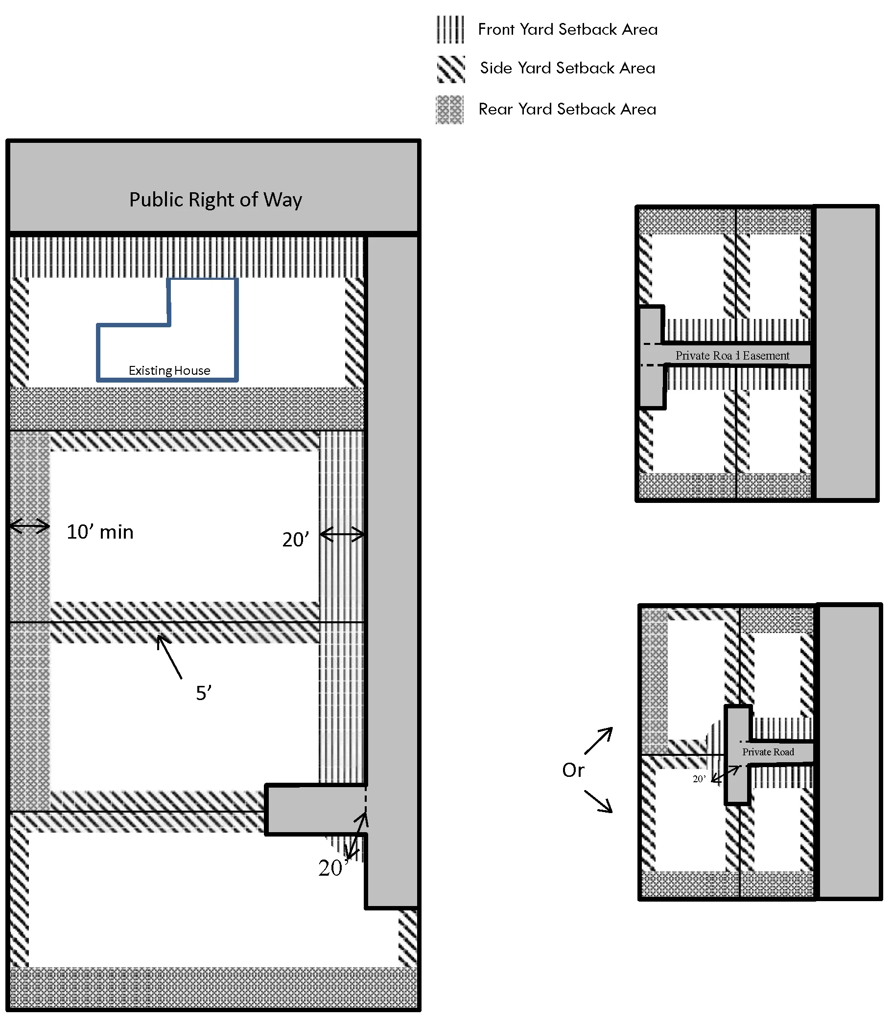
5.4.3. Multifamily Residential Development Standards
Section titled “5.4.3. Multifamily Residential Development Standards”[AMENDED 07-16-2020] [AMENDED 09-09-2022]
5.4.3.A. Applicability
Section titled “5.4.3.A. Applicability”[AMENDED 09-09-2022]
-
The standards of Section 5.4.3.B apply to:
- Lots created for Multifamily Residential projects in all zones, where allowed.
- See Section 5.4.2.B for Single-Family Attached or Detached and Duplex/Halfplex Residential lot standards in all zones, where allowed.
-
The standards of Section of 5.4.3.C apply to:
- Projects for Multifamily Residential in all zones where permitted but not governed by other specific plan, special planning area, or neighborhood preservation area standards. This shall include all new construction, retrofitting, and remodeling of existing construction of the above.
- See Section 5.4.2.C for Single-Family Attached or Detached and Duplex/Halfplex Residential project standards in all zones, where allowed.
-
Alternatives to these standards may be approved through either a Minor Special Development Permit or a Special Development Permit approved by the Zoning Administrator, pursuant to the provisions of Section 6.4.6.D if the intent and purpose of the standards and guidelines are met.
-
The standards in this Section are to be used in close concert with the County-wide Design Guidelines and Design Standards to achieve high quality projects that fit within the surrounding community. All multifamily residential projects are subject to Design Review.
5.4.3.B. Lot Standards - Multifamily Residential
Section titled “5.4.3.B. Lot Standards - Multifamily Residential”[AMENDED 09-09-2022]
-
Densities allowed in the RD-15 through RD-40 zones are listed in Table 5.8.A.
-
Lots created for multifamily residential use in all zones, where allowed, shall be subject to the standards of Table 5.8.A.
-
For the creation of new lots, the lot area and width requirements regulate minimum lot size and configuration for each zoning district and are not necessarily as optimum project design standards. Refer to the Countywide Design Guidelines for ways to provide compatibility, access and connectivity with surrounding neighborhoods.
-
Alternatives to all standards except density may be approved with a Special Development Permit if the intent and purpose of the Standards and Guidelines are met.
Table 5.8.A Lot Standards – Multifamily Residential [AMENDED 09-09-2022]
Section titled “Table 5.8.A Lot Standards – Multifamily Residential [AMENDED 09-09-2022]”| Required Lot Standard | RD-15 | RD-20 | RD-25 | RD-30 | RD-40 | All Other Zones Where Permitted |
|---|---|---|---|---|---|---|
| Maximum Allowed Density (dwelling units/net acre) [1] | 15 | 20 | 25 | 30 | 40 | [2] |
| Minimum Net Interior Lot Area (square feet) [3] | 5,200 | 5,200 | 5,200 | 5,200 | 5,200 | 5,200 |
| Minimum Net Corner Lot Area (square feet) [3] | 6,200 | 6,200 | 6,200 | 6,200 | 6,200 | 6,200 |
| Interior Lot Width (feet) [3] | 52 | 52 | 52 | 52 | 52 | 52 |
| Corner Lot Width (feet) [3] | 62 | 62 | 62 | 62 | 62 | 62 |
[1] New lots created with Parcel Maps shall use the density calculation methodology of Section 7.1.13. See Section 5.2.3. for density bonuses or intensity increases. Density bonuses are automatic when State Density Bonus. A Special Development Permit is required for density bonus projects not using the above criteria as noted in Section 6.4.6.G.
[2] See Section 3.5.1.B through 3.5.1.J for allowed densities for residential product types in all other zones, where allowed.
[3] Lot standards included in the table are for when public water and sewer are in use. Minimum lot requirements for all multifamily development where a public sewer facility is not in use: 1) minimum lot area of one acre for residential uses and non-residential uses, where permitted; 2) minimum interior lot and/or public street frontage width of 52 feet; and 3) minimum corner lot and public street frontage width of 62 feet. Lot requirements for all multifamily development where neither a public water nor a public sewage facility is in use includes: 1) minimum lot area of one acre; 2) minimum interior lot and/or public street frontage width of 52 feet; and 3) minimum corner lot and public street frontage width of 62 feet. Public water facilities shall be required for all subdivision projects.
5.4.3.C. Project Development Standards – Multifamily Residential
Section titled “5.4.3.C. Project Development Standards – Multifamily Residential”[AMENDED 09-09-2022]
All multifamily projects shall be subject to the development standards of Table 5.8.B.
Table 5.8.B Development Standards - Multifamily Residential
Section titled “Table 5.8.B Development Standards - Multifamily Residential”[AMENDED 09-09-2022]
This table has been split into multiple parts to comply with accessibility requirements. The following six tables and two subsections (Driveway Dimensions, Lighting for Multifamily Housing) shall all be referred to as a part of Table 5.8.B.
| Development Standard | Requirement |
|---|---|
| Minimum Front Yard [1][2] | 20 ft (Without PUPF) / 24 ft (With PUPF) |
| Interior Side and Rear Yards (feet) – Adjacent to or Within Low Density Residential Zoning Districts [2] | - 25 (1 story) - 50 (2 story) - 75 (3 story) - 75 [4 story (when adjacent to collector/arterial or approved by SPZ)] |
| Interior Side and Rear Yards (feet) - All Other Circumstances [3] | 10 (1 and 2 story), 15 (3 story +) |
| Side Street Yard | 15 (Without PUPF) / 21 (With PUPF) |
| Upper Story Stepbacks | Multistory buildings may be stepped-back to achieve minimum setback requirements for upper stories as shown in Figure 5-11 and provided for in Chapter 3 of the Countywide Design Guidelines. Stepped-back upper stories may be utilized regardless of whether located adjacent to an LDR zone so long as each story meets the minimum setback requirements. |
| Multifamily Amenity Structures [4] | All Amenity Structures must remain outside of required perimeter landscape areas. Structures over one story or 20 feet in height must also meet setbacks of similar story multifamily structure. |
Allowed Encroachment (Porches/Stoops/Patios/Bay Windows/Balconies into the):
Section titled “Allowed Encroachment (Porches/Stoops/Patios/Bay Windows/Balconies into the):”| Setback Area | Adjacent to or within LDR | All other circumstances |
|---|---|---|
| Front Yard | 2 ft. | 8 ft. |
| Side Yard | 10 ft. | 2 ft. |
| Rear Yard | 10 ft. | 2 ft. |
Allowed Encroachment over Sidewalk (Awnings/Bay Windows/Upper Floors)
Section titled “Allowed Encroachment over Sidewalk (Awnings/Bay Windows/Upper Floors)”| Setback Area | All circumstances |
|---|---|
| Front Yard | Not allowed in the RD-10 zone. Three feet max., with eight feet min. height clearance from top of sidewalk in all other zoning districts. |
Maximum Height and Story Limits
Section titled “Maximum Height and Story Limits”| Development Standard | Requirement |
|---|---|
| Maximum Height (feet) and Stories - Adjacent to or Within Low Density Residential Zoning Districts [2] | 40 feet and three stories (except when adjacent to major collectors or arterials, see Allowed Height Increase- Major Collectors and Arterials, below). |
| Maximum Height (feet) and Stories - All Other Circumstances | - RD-15: 40 ft. and three stories - RD-20 and RD-25: 45 ft. and four stories - RD-20 and all other zoning districts: 150 ft. and no story limit |
| Allowed Height Increase- Major Collectors and Arterials | Heights may be increased by one story along major collector and arterial street with widths of 80 feet or more. See Section 5.2.2 for height increases adjacent to transit. |
Open Space Requirements [5]
Section titled “Open Space Requirements [5]”| Development Standard | Requirement |
|---|---|
| Minimum Open Space and Landscaping (i.e. yards and landscaped setbacks) | 25 percent of net lot area |
| Common Outdoor Amenities Required | For 10 units or more |
| Minimum Private Open Space/Unit (square feet) | For buildings greater than four stories, private open space may be substituted by common amenities such as gyms, game rooms, roof decks, or communal kitchens at a rate of 40 square feet of common space per unit. |
All Other Requirements
Section titled “All Other Requirements”| Development Standard | Requirement |
|---|---|
| Private Storage Requirement - Minimum Storage Area Volume/Unit (cubic feet) | 80 cf |
| Parking Requirements | For multifamily residential parking requirements, refer to Section 5.9, “Off-Street Parking;” Table 5.18, “Vehicle Parking Amount for Residential Uses.” |
| Signage Requirements | Signs shall be integrated and designed at a quality consistent with the design of the project and shall comply with Chapter 5.10, “Sign Regulations.” |
| Walls and Fences | Walls and fences shall be located and constructed in conformance with Section 5.2.5, “Development Standards for Walls and Fences.” |
| Landscaping | Landscaping shall be provided in conformance with Section 5.2.4. |
| Waste Enclosure Setbacks | 25 ft. from any public right-of-way 15 ft. from residentially-zoned property 15 ft. from the edge of a private road easement |
| Waste Enclosure Requirements | All waste containers shall be located within an enclosed masonry area with a surrounding wall at least six feet high and no taller than eight feet in height, with an appropriate solid gate. Enclosure areas shall be designed to the County’s latest stormwater quality source control design standards, including drains and covers, if required. Container sizes for waste, recycling and/or organics shall meet the requirements of Waste Management and Recycling Department. There shall be adequate area provided for required waste containers within enclosures. Enclosures shall be located for functional use by occupants and by the disposal and hauling companies, providing collection services. |
| Maintenance | All development standards shall be continuously met for every project. Buildings and premises, including paint/siding, roofs, windows, fences, parking lots, and landscaping shall be kept in good repair. Premises shall be kept free of junk, debris, and abandoned vehicles. |
| Acoustical Analysis | For projects that include the construction of residential units within 25 feet of an arterial or thoroughfare right-of-way (as identified by the roadway classifications in the General Plan), project applicants shall submit an acoustical analysis demonstrating façade construction will be such that interior noise levels will not exceed 45dB Ldn under future (cumulative case) traffic conditions. |
Driveway Dimensions
Section titled “Driveway Dimensions”- Street design and width shall be confirmed with the Fire Department.
- For driveway access with 10 or fewer units, a T-shaped turnaround shall be allowed. A dimension of 20 feet by 80 feet will accommodate most vehicles.
- Dead end driveways shall be less than 150 feet long, and have appropriate turnarounds as needed.
- Circular cul-de-sacs shall be designed with a radius of 40 feet or less to the greatest extent possible.
- The minimum widths for internal streets or driveways, per Fire Department Standards, shall be as follows:
- For uncurbed driveways with no parallel parking when a fire lane is not necessary: 16 feet.
- For curbed internal streets with no parallel parking: 19 feet.
- or curbed internal street with parallel parking on one side: 28 feet.d. For curbed internal street with parallel parking on both sides: 36 feet.
Lighting for Multifamily Housing
Section titled “Lighting for Multifamily Housing”- Site and street lighting shall comply with Section 5, “Street Light Design” of the Sacramento County Improvement Standards and the following standards.
- Lighting fixtures shall provide for pedestrian safety and be adequately spaced and scaled without interference from landscaping.
- Illumination shall be 0.25 foot-candles at grade level for surface areas of alcoves, walkways, and yards other than required for exits.
- Illumination shall be one foot-candle at floor level for open parking areas and carports.
- All lights shall be placed on a timer or photo electronic cell capable of turning the lights on and off one-half hour prior to dawn and one-half hour past dusk.
- Lighting shall be constructed with full shielding and/or recessed to reduce light trespass to adjoining properties. Each fixture shall be directed downward and away from adjoining properties and public right-of-way, so that no light fixture directly illuminates an area outside of the site, and the light source is not visible from residential properties. New light fixtures shall be full cut-off fixtures as defined by the Illuminating Engineering Society of North America.
PUPF = Public Utilities, Public Facilities easement (per Section 5.2.1)
[1] Setback requirements, encroachments, and internal street widths are subject to review by local service providers and may be restricted based on the County Access Drive Standards or other guidelines used for multifamily residential developments to ensure adequate spacing is available for all necessary utilities.
[2] In this circumstance, Low Density Residential encompasses AG, AR and RD-1 through RD-10 zones. For these standards, ‘adjacent’ shall mean sharing at least one property boundary outside of the Right-of-Way (ROW). Additional yard area applies only to shared property boundary areas, if adjacent to Low Density Residential.
[3] Contiguous parcel boundaries may be ignored if parcels are being developed as a single project.
[4] Amenity structures include carports, pool houses, garages, laundry rooms, leasing offices, and other structures when not attached to Multifamily Residential units.
[5] Common open space and outdoor amenities can include common patios, small common greens, community gardens, pools, pedestrian walkways, tot-lots, and recreation areas. It does not include areas used for vehicular access and parking. Public parks and open space constructed as part of the proposed multifamily project may be counted up to one-half of the common open space requirement.
Figure 5-11: Example of a Stepped Back Multifamily Building
Section titled “Figure 5-11: Example of a Stepped Back Multifamily Building”[ADDED 09-09-2022]
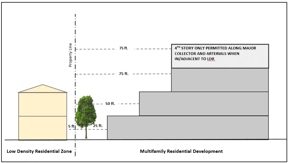
5.4.4. Mobilehome Subdivision Development Standards
Section titled “5.4.4. Mobilehome Subdivision Development Standards”[AMENDED 07-16-2020]
5.4.4.A. Applicability
Section titled “5.4.4.A. Applicability”This Section provides regulations for the placement of mobilehomes on individual lots with an approved subdivision specifically designed and designated RM-2 for the sale, not rental, of lots to accommodate mobilehomes as the dwelling unit. Standards for mobilehome parks can be found in Section 4.4. Mobile Home Park (MHP) Combining Zoning District.
5.4.4.B. Standards for Mobilehome Subdivisions and Manufactured Homes
Section titled “5.4.4.B. Standards for Mobilehome Subdivisions and Manufactured Homes”A Mobilehome Subdivision developed under the RM-2 zone shall comply with the development standards of Table 5.7.A. for RD-5 zoned properties. A manufactured home shall comply with the development standards for detached single-family residential units in Table 5.7.B. and the architectural standards of Section 5.4.2.D.
Table 5.9 Mobile Home (RM-2) Subdivision Development Standards
Section titled “Table 5.9 Mobile Home (RM-2) Subdivision Development Standards”DELETED
5.4.5. Residential Accessory Structures, and Accessory Dwelling Units
Section titled “5.4.5. Residential Accessory Structures, and Accessory Dwelling Units”[AMENDED 09-09-2022]
5.4.5.A. Development Standards for Residential Accessory Structures
Section titled “5.4.5.A. Development Standards for Residential Accessory Structures”-
The development standards in Table 5.10.A apply to all Residential Accessory Structures listed in Section 3.9.3.CC that are constructed, enlarged, or otherwise modified in all zones where allowed.
-
The development standards in Table 5.10.B apply to all Incidental Agricultural Accessory Structures listed in Section 3.9.3.G that are constructed, enlarged, or otherwise modified in Residential zoning districts. See Section 5.3.2.C for Incidental Agricultural Accessory Structure standards in Agricultural and Agricultural-Residential zoning districts.
-
Deviations from the standards of this Section may be permitted with a Special Development Permit approved by the Zoning Administrator, subject to the General Findings in Section 6.4.6.H.1.
Table 5.10.A Development Standards – Residential Accessory Structures in All Zoning Districts, As Allowed
Section titled “Table 5.10.A Development Standards – Residential Accessory Structures in All Zoning Districts, As Allowed”This table has been split into multiple tables to comply with accessibility requirements. The following three tables shall all be referred to as a part of Table 5.10.A.
In-Ground Swimming Pools and Spas
Section titled “In-Ground Swimming Pools and Spas”| Development Standard | Requirement |
|---|---|
| Minimum Setback Requirements | Swimming pools and spas may not be located within the required front or side street yard, or within a recorded setback, except the rear yards of through lots unless otherwise prohibited by a recorded subdivision map. Pools do not have a minimum setback from primary dwellings, but edge of water must be three feet from the rear and side property line. |
| Easement Areas | Swimming pools and spas may not be located within a public utility easement; or within a public easement. |
Guest Houses [1]
Section titled “Guest Houses [1]”| Development Standard | Requirement |
|---|---|
| Maximum Square Footage | Guest houses may include up to 500 sq. ft. of conditioned space. |
| Internal Design | Guest houses are limited to one primary room and one bathroom. Closets are allowed but cannot be greater than three feet in depth. |
| Cooking Facilities | Guest houses shall not include cooking appliances, such as an oven or cooktop/range. |
| Maximum Attached Unconditioned Space | Attached unconditioned space is not limited, except by the overall maximum accessory structure square footage for a parcel. |
| All Other Standards | As stated under ‘All Other Residential Accessory Structure Types.’ |
All Other Residential Accessory Structure Types [2]
Section titled “All Other Residential Accessory Structure Types [2]”| Development Standard | Requirement |
|---|---|
| Maximum Square Footage | The area of all accessory structures on a single parcel, shall not exceed [3]; - For lots less than 20,000 sq. ft. in gross area: 50% of the habitable floor area of the primary residential dwelling. - For lots 20,000 sq. ft. in gross area or greater, 100% of the habitable floor area of the primary dwelling. |
| Maximum Building Coverage | 30% of required rear yard [3] |
| Maximum Height to peak of roof (feet) | 16 (14 feet to plate line) |
| Number of Stories | 1 |
| Separation from Primary Dwelling | Residential Accessory Structures must remain detached from Primary Dwellings. |
| Front Yard Setback (feet) [4][6] | 20 |
| Interior Side and Rear Yard Setback (feet) [4][5][6] | 3 |
| Side Street Yard Setback (feet) [4][6] | 12.5 |
| When Adjacent to Primary Structure | If less than six feet from the wall of the primary residence, accessory structures of any size must meet the same setback as the primary residence. |
| Minor Accessory Structures | Minor structures or sheds which do not exceed 120 square feet in area and nine feet in height overall may be placed on the property line. |
Maximum Permitted Encroachment Into Required Yard Areas (feet)
Section titled “Maximum Permitted Encroachment Into Required Yard Areas (feet)”| Required Yard | Allowed Encroachment |
|---|---|
| Front Yard and Side Street Yard | Air Conditioning Equipment: 5 [7] Other Mechanical Equipment: 5 [7] |
| Interior Side Yard and Rear Yard | Air Conditioning Equipment: 0 Other Mechanical Equipment: 5 [8] |
PUPF = Public Utilities, Public Facilities easement (per Section 5.2.1)
[1] Refer to Section 5.4.5.B for Accessory Dwelling Unit development standards.
[2] Refer to Section 5.2.5.B, “Development Standards for Walls and Fences” for complete fencing standards.
[3] For the purpose of this calculation, all roofed space, enclosed or not, shall be counted as space occupied by accessory buildings, except for the habitable space of an ADU.
[4] Accessory structures must maintain a minimum three foot setback from property lines for any portion of the structure including eaves and overhangs.
[5] Setbacks less than 5 ft. from property line or other structures may require fire walls and/or restrictions on non-protected openings as determined by Fire and Building Permits and Inspection.
[6] If the site has a PUPF that is greater than the listed setback, it becomes the minimum setback requirement.
[7] Provided said equipment is within a solid fenced yard or enclosure.
[8] Provided equipment shall be no closer than two feet from any property line.
FIGURE 5-11
Section titled “FIGURE 5-11”[DELETED]
Table 5.10.B Development Standards – Incidental Agricultural Accessory Structures in Residential Zoning Districts
Section titled “Table 5.10.B Development Standards – Incidental Agricultural Accessory Structures in Residential Zoning Districts”This table has been split into multiple parts to comply with accessibility requirements. The following subsection and table shall all be referred to as a part of Table 5.10.B.
Maximum Square Footage - General
Section titled “Maximum Square Footage - General”This maximum square footage applies to all types of incidental agricultural accessory structures, unless specifically noted in “Maximum Square Footage (sq. ft) - Specific”
The area of all accessory structures on a single parcel, shall not exceed [1]:
- For lots less than 20,000 sq. ft. in gross area: 50% of the habitable floor area of the primary residential dwelling.
- For lots 20,000 sq. ft. in gross area or greater, 100% of the habitable floor area of the primary dwelling.
| Standard | Incidental Agricultural Accessory Structures | Aviaries / Chicken Coops | Hog Barn / Pen |
|---|---|---|---|
| Maximum Square Footage (sq. ft) - Specific | N/A | 30 [2] | 500 each pen area / building areas |
| Maximum Building Coverage | 30% of required rear yard [1] | N/A | N/A |
| Maximum Height to Peak of Roof (ft) | 24 | 8 | 16 [3] |
| Minimum Front Yard Setback (feet) [4][5] | 25 | N/A [6] | N/A [6] |
| Minimum Interior Side and Rear Yard Setback (feet) [4][5] | 10 | 3 [7] | 50 |
| Minimum Side Street Yard Setback (feet) [4][5] | 12.5 | 3 [7] | 50 |
| Minimum Setback from Primary Structure (feet) [4][5] | 10 | N/A | N/A |
| Maximum Permitted Encroachment Into Required Front and Side Street Yard (feet) | Air Conditioning Equipment: 5 [8] Other Mechanical Equipment: 5 [8] | 5 [8] | N/A |
| Maximum Permitted Encroachment Into Required Interior Side and Rear Yard (feet) | Air Conditioning Equipment: 0 Other Mechanical Equipment: 5 [9] | N/A | N/A |
N/A = Not Applicable, PUPF = Public Utilities, Public Facilities easement (per Section 5.2.1)
[1] For the purpose of this calculation, all roofed space, enclosed or not, shall be counted as space occupied by accessory buildings, except for the habitable space of an ADU.
[2] A minimum of three square feet per bird shall be provided to a maximum of 30 square feet.
[3] Not to exceed one story and plat line not to exceed 10 feet.
[4] Setbacks are for all portions of the structure, including eaves and overhangs.
[5] If the site has a PUPF that is greater than the listed setback, it becomes the minimum setback requirement.
[6] Chicken and hog keeping is allowed in the rear yard only.
[7] A minimum 20-foot setback from all neighboring residential dwellings.
[8] Provided said equipment is within a solid fenced yard or enclosure.
[9] Provided equipment shall be no closer than two feet from any property line.
5.4.5.B. Development Standards for Accessory Dwelling Units and Junior Accessory Dwelling Units in All Zoning Districts
Section titled “5.4.5.B. Development Standards for Accessory Dwelling Units and Junior Accessory Dwelling Units in All Zoning Districts”[AMENDED 09-09-2022][AMENDED 07-11-2024]
-
The development standards in Table 5.11 apply to Accessory Dwelling Units (ADUs) and Junior Accessory Dwelling Units (JADUs) that are constructed, enlarged, or otherwise modified in all zones, where permitted.
-
With the exception of maximum size, requests for deviations from development standards listed in this Section may be permitted with either a Special Development Permit or Planning Director Determination, subject to the General Findings in Chapter 6 and compliance with State regulations (denoted in Table 5.11).
Table 5.11 Development Standards for ADUs and JADUs in All Zoning Districts Where Permitted
Section titled “Table 5.11 Development Standards for ADUs and JADUs in All Zoning Districts Where Permitted”[AMENDED 09-09-2022][AMENDED 07-11-2024]
This table has been split into multiple tables to comply with accessibility requirements. The following three tables shall all be referred to as a part of Table 5.11.
General Standards
Section titled “General Standards”| Development Standard | Requirement |
|---|---|
| Number of ADUs and JADUs Per Single Family or Halfplex [1] | 1 ADU and 1 JADU |
| Number of ADUs Per Multifamily Project [2][3] | New Construction Properties developed as multifamily may have up to two new construction detached ADUs. Conversion Properties developed as multifamily may have up to 25% of total unit count in ADUs converted from existing non-living space. [4] Development Standards Except for sites developed with a single Duplex, new construction and conversions that affect exterior facades shall meet the multifamily development standards in Section 5.4.3 and Chapter 3.0 of the Countywide Design Standards, “Multifamily Design Standards” for standards not otherwise addressed in this Tabl |
| Bathroom Facilities [2] | Attached and detached ADUs are required to have separate bathroom facilities from the primary dwelling. JADUs may have separate bathroom facilities or shared facilities with the primary dwelling. If the JADU does not include a separate bathroom from the primary dwelling, the JADU shall have both a separate entrance from the primary dwelling as well as an interior entry to the main living area of the primary dwelling to access the shared bathroom facilities. |
| Kitchen Requirement [2] | All ADUs are required to have a kitchen that includes a cooktop/stove and oven or range. JADUs shall have at least an efficiency kitchen. |
| Minimum ADU or JADU Size (Habitable Square Feet) | 150 sq. ft. |
| Minimum Building Width | N/A |
| Equipment Encroachment Allowances | Encroachment Allowances as Listed in Section 5.4.5.A, Table 5.10.A. |
| Access [2] | Exterior access separate from the primary dwelling is required. |
| Owner-occupancy JADU [2] | The property owner must occupy either the primary dwelling or JADU. Owner occupancy is not required if the owner is a governmental agency, land trust, or housing organization. |
| Recordation of Deed Restriction- JADU | A Deed Restriction shall be recorded that prohibits sale of the JADU separate from the sale of the single-family residence and restricts the size and attributes of the JADU to conformance with CA GOV §65852.22, as amended from time to time. |
| Dwelling Unit Separation Requirements | ADU - For purposes of any fire or life protection ordinance or regulation, an Accessory Dwelling Unit shall be considered a separate or new dwelling unit. JADU - For purposes of any fire or life protection ordinance or regulation, a Junior Accessory Dwelling Unit shall not be considered a separate or new dwelling unit. |
| Minimum Parking | For ADUs, one parking space shall be provided, except that parking is not required where:
|
Additional Standards - New Construction
Section titled “Additional Standards - New Construction”| Development Standard | Requirement |
|---|---|
| Maximum Size - ADU [5][6] | Detached 1,200 sq. ft. Attached 50% of the habitable sq. ft. of the primary dwelling, or 800 sq. ft., whichever is greater. |
| Maximum Size – JADU [2][7] | 500 sq. ft. of space within proposed primary dwelling (including attached garages or attached storage areas), plus 150 sq. ft. for ingress/egress. |
| Maximum Building Height to peak [8] | Detached
Attached 25 ft. ADU in Multifamily 18 ft. |
| Foundation | All ADUs shall be constructed on a permanent foundation. |
| Setbacks [9][10] | Front Yard – 20 ft. [6][12] Side Street Yard (corner) – 12.5 ft. [6][12] Side and Rear Yard – 4 ft. |
| Maximum Non-Habitable Square Footage Attached to Detached ADU [11] | Maximum shall be as listed for Residential Accessory Structures in Table 5.10.A and shall be counted towards that square footage limit. |
Additional Standards - Conversion of Existing Space/Structure [13]
Section titled “Additional Standards - Conversion of Existing Space/Structure [13]”| Development Standard | Requirement |
|---|---|
| Existing Space/ Structure | Existing space/structure is limited to permitted space or structures on the subject parcel. |
| Maximum Size – ADU [2] | Area of existing space/structure, plus 150 sq. ft. for ingress/egress. |
| Maximum Size – JADU [2][7] | 500 sq. ft. of existing space within primary dwelling (including attached garages or attached storage areas), plus 150 sq. ft. for ingress/egress. |
| Setbacks | Ingress/egress additions shall meet setbacks for new construction ADUs or Junior ADUs. Existing space/structures may remain at setbacks originally permitted. |
| Conversion of Covered Parking | When a garage, carport, or covered parking structure is demolished or converted in conjunction with the construction of an accessory dwelling unit, replacement parking shall not be required and may be located in any configuration on the same lot as the accessory dwelling unit. |
[1] ADU/JADU units cannot be combined with SB 9 projects to increase the number of allowed dwellings. SB 9 projects are limited to two dwelling units (Primary plus either an SDU, ADU, or JADU) per parcel.
[2] Mandated by State statute. A Minor Special Development Permit or minor deviation from the Planning Director cannot be applied for to deviate from this standard.
[3] ‘Multifamily’ for purposes of compliance with State ADU regulations shall mean two or more units on a parcel.
[4] Non-livable space can include storage rooms, boiler rooms, passageways, attics, basements, or garages.
[5] Maximum size limit of a detached ADU is 1,200 square feet for new construction, no further increases allowed.
[6] Minor deviations to this standard (i.e., front or side-street setback; lot coverage; or open space requirements) may be approved administratively by the Planning Director when it can be demonstrated that full implementation of the standard would physically prevent the ability to develop up to an 800 square foot attached or detached ADU within the buildable area of the lot. Deviations to this standard to allow for dwellings larger than 800 square feet and up to 1,200 square feet require approval of an applicable Special Development Permit.
[7] Deviations from maximum JADU size are not permitted.
[8] Detached or attached ADUs may only be a single story. Detached ADUs requesting a height above 16 feet and up to 18 feet in height (peak) due to proximity to major transit pursuant to CA PRC §21155 or to match the roof pitch of the primary dwelling may be approved by the Planning Director. For height increases to accommodate roof pitch alignment with primary dwelling, documentation shall be provided demonstrating both the existing roof pitch of primary dwelling and proposed ADU. Height requests above those provided in the table may be approved through an applicable Special Development Permit.
[9] Setbacks less than five feet from property line or other structures may require fire walls and/or restrictions on non-protected openings as determined by Fire and Building Permits and Inspection.
[10] Attached and Detached ADU setbacks are both measured from the wall of the unit to the property lines. Up to a 24-inch overhang into the required setback area is allowed.
[11] Habitable square footage of an ADU shall not be counted towards the Accessory Structure space maximum of Table 5.10.A.
[12] Properties located within area-specific zoning ordinances such as but not limited to Special Planning Areas, Neighborhood Preservation Areas or Planned Developments shall utilize the front yard and side street yard (corner) setbacks specified in the applicable ordinance.
[13] Conversions of existing dwellings to Accessory Dwelling Units in conjunction with development of a new primary dwelling may utilize these standards.
5.4.6.
Section titled “5.4.6.”[DELETED 12-01-2017]
5.5. COMMERCIAL ZONING DISTRICTS
Section titled “5.5. COMMERCIAL ZONING DISTRICTS”[AMENDED 07-16-2020]
5.5.1. Purpose and Applicability
Section titled “5.5.1. Purpose and Applicability”[AMENDED 01-12-2019]
The standards in this Section apply to:
-
Lots within the BP, C-O, LC, GC zones and lots created for commercial or institutional uses in other zoning districts where allowed, and,
-
All commercial and institutional projects including new construction, retrofitting, and remodeling of existing construction in all zones where permitted but not governed by other specific plan, special planning area, or neighborhood preservation area standards.
The standards in this Section are to be used in close concert with the County-wide Design Guidelines to achieve high quality projects that fit within the surrounding community. All commercial and institutional projects are subject to Design Review.
Alternatives to these standards may be approved with a Special Development Permit if the intent and purpose of the standards and guidelines are met.
5.5.2. Commercial and Institutional Development Standards
Section titled “5.5.2. Commercial and Institutional Development Standards”5.5.2.A. Development Standards Summary
Section titled “5.5.2.A. Development Standards Summary”Lots created within commercial zoning districts or for commercial or institutional purposes in other zoning districts where allowed, and all commercial and institutional projects, shall be subject to the development standards of Table 5.13, as follows:
-
For the creation of new lots, the lot area and width requirements of Table 5.13 regulate minimum lot size and configuration for each zoning district and are not necessarily as optimum project design standards. Refer to the Countywide Design Guidelines for ways to provide compatibility, access and connectivity with surrounding neighborhoods.
-
Development of commercial projects in the commercial zoning districts is subject to the applicable development standards in Table 5.13.
-
Development of commercial projects in non-commercial zoning districts is subject to the lot and development standards of the LC/GC zones as summarized in Table 5.13.
-
Development of institutional projects is subject to the development standards of the BP zone unless specified in Table 5.13.
All commercial and institutional development is subject to Design Review in accordance with the County-wide Design Guidelines.
Table 5.13 Commercial Lot and Commercial and Institutional Project Development Standards
Section titled “Table 5.13 Commercial Lot and Commercial and Institutional Project Development Standards”This table has been split into multiple tables to comply with accessibility requirements. The following four tables shall all be referred to as a part of Table 5.13.
Commercial Lot Standards
Section titled “Commercial Lot Standards”| Required Development Standard | BP | C-O | LC, GC |
|---|---|---|---|
| Minimum Lot Area (sq. ft.) | N/A [1] | N/A [1] | N/A [1] |
| Minimum Lot Frontage and Width (ft.) | 60 | 66 | N/A |
| Minimum Lot Depth | 100 | N/A | N/A |
Development Standards - Institutional Uses
Section titled “Development Standards - Institutional Uses”| Development Standard | Requirement |
|---|---|
| Applicable standards in commercial or industrial zoning districts, except the BP zone | Institutional uses located in a commercial or industrial zoning district, except for the BP zone, shall use the LC, GC development standards. |
| Applicable standards in the BP zone | Institutional uses located in the BP zone shall follow the BP zone development standards. |
| Applicable standards in all other zoning districts | Institutional uses in all other zoning districts shall use the BP development standards, except for yards, as specified. |
| Yard requirements when located within a zoning district other than commercial or industrial | Front Yard – 25 ft. (Without PUPF) / 31 ft. (With PUPF) Interior Side Yard – Minimum 6 ft. Rear Yard – Minimum 25 ft. |
Development Standards - Yard Requirements (ft.) Commercial Uses
Section titled “Development Standards - Yard Requirements (ft.) Commercial Uses”| Required Development Standard | BP | C-O | LC, GC |
|---|---|---|---|
| Minimum Required Front Yard | 25 (Without PUPF) / 31 (With PUPF) | 50 (Without PUPF) / 56 (With PUPF) | 50 (Without PUPF) / 56 (With PUPF) |
| Minimum Required Interior Side and Rear Yards, Adjacent to Multifamily Use [2] | 25 | 25 | 20 |
| Minimum Required Interior Side and Rear Yards, Adjacent to Nonresidential Use [2] | 0 | 0 | 0 |
| Minimum Required Interior Side and Rear Yards, Abutting Freeway or Scenic Corridor | If the rear yard or interior side yard abuts a freeway or scenic corridor, a minimum 15-foot rear or interior side yard setback shall be provided. The entire 15-foot setback shall be landscaped. | If the rear yard or interior side yard abuts a freeway or scenic corridor, a minimum 15-foot rear or interior side yard setback shall be provided. The entire 15-foot setback shall be landscaped. | If the rear yard or interior side yard abuts a freeway or scenic corridor, a minimum 15-foot rear or interior side yard setback shall be provided. The entire 15-foot setback shall be landscaped. |
| Minimum Required Interior Side and Rear Yard, Adjacent to Single-Family Residential Use | 25 (one-story); 100 (two-story and three-story) | 25 (one-story); 100 (two-story and three-story) | 25 (one-story); 100 (two-story and three-story) |
| Projection Into Rear Yard | The main building may project into the required rear yard provided that an equal area is provided as a yard or court within the buildable portion of the lot. | The main building may project into the required rear yard provided that an equal area is provided as a yard or court within the buildable portion of the lot. | The main building may project into the required rear yard provided that an equal area is provided as a yard or court within the buildable portion of the lot. |
| Minimum Required Side Street Yard | 25 (Without PUPF) / 31 (With PUPF) | 50 (Without PUPF) / 56 (With PUPF) | 50 (Without PUPF) / 56 (With PUPF) |
Development Standards - All Other Requirements, Commercial Uses
Section titled “Development Standards - All Other Requirements, Commercial Uses”| Development Standard | Requirement |
|---|---|
| Maximum Building Height (ft.) | 50 |
| Minimum Landscape Requirements | Refer to Section 5.2.4, “Landscape Standards.” |
| Additional Landscaping Requirement | All setback areas visible from public streets shall be landscaped. Required planter or landscaped areas shall include pedestrian walks, steps, and similar hard surface areas provided that such hard surface does not cover more than 25% of the required landscaped area. Ornamental or landscaping rock and gravel areas, artificial turf, or areas covered with other artificial materials shall be considered hard surface areas for the purposes of this provision. |
| Landscaping to Allow Yard Reduction | In the C-O, LC, and GC zones, the front yard depth may be reduced to a minimum of 25 feet, and to a minimum of 31 feet for right-of-way with a PUPF, provided that for each square foot of additional buildable area created by the application of this provision, an equivalent square foot of landscape area is provided in the corresponding street yard. |
| Parking Requirements | Refer to Section 5.9, “Off Street Parking” |
| Lighting | Site and street lighting shall comply with Section 5, Street Light Design of the Sacramento County Improvement Standards. Also refer to Section 5.9.4.G for Parking Area Lighting standards. |
| Signage | Signs shall be integrated and designed at a quality consistent with the design of the project and shall comply with Chapter 5.10, Sign Regulations and the County’s Design Guidelines. |
| Shopping Carts | All businesses shall comply with Chapter 9.76 of the SCC relating to Unauthorized Use of Shopping Carts. |
| Compliance with Noise Ordinance (SCC Section 6.68) | All commercial activities, including truck loading, operation of machinery, and human activity areas, located within proximity of a residential or agricultural-residential zoning district shall comply with the County Noise Ordinance. If complaints are received and non-compliance verified by the Environmental Management Department, then the Planning Director may require the property owner to submit an acoustical study prepared by a qualified acoustical engineer. Said study shall provide recommended physical and operational measures to bring the property into compliance. The Planning Director may require compliance with such measures as a condition of the business license as provided for in SCC Section 4.06.090. This requirement shall be applicable to existing and new commercial uses. |
| Circulation | Incorporate attractive and well-marked pedestrian networks that provide connectivity and safe travel from the public rights-of-way and through parking areas. Design shall reflect the need for safely mixing and separating modes (i.e. trucks, autos, transit, pedestrians and bicyclists), while enhancing the pedestrian linkages to other buildings, transit and parking areas. |
| Access | Provide cross-access between projects to the extent practicable to support mixed use development, active design and walkability. |
| Outdoor Merchandise Display [ADDED 01-12-2019] | Within the buildable area of a lot, material, goods, furniture, and appliances, normally used out of doors, which are sold on-site, may be allowed to be displayed outdoors during hours of operation when accessory to a permitted commercial use. Displays may be allowed within required setback areas adjacent to roadways with the issuance of a Minor Use Permit; however, displays must maintain a minimum 25-foot setback. Displays shall not block vehicular or pedestrian pathways or be located in required parking or landscaped areas. |
| Outdoor Storage [ADDED 01-12-2019] | Within the buildable area of a lot, the outdoor storage of goods, if new or in good repair, may be allowed if completely screened from view in accordance with Section 5.2.5.D, “Commercial and Industrial Fences.” Such storage shall not block vehicular or pedestrian pathways or be located in required parking or landscaped areas. |
Trash and Recycling Enclosures and Loading Docks
Section titled “Trash and Recycling Enclosures and Loading Docks”| Development Standard | Requirement |
|---|---|
| Minimum Setback from Public Street (ft.) | 31 |
| Minimum Setback from residentially-zoned property, or property used for residential purposes (ft.) | 25 |
| Minimum Setback from the edge of pavement of a private street | 15 |
| Required Gate Height | Six-foot minimum and eight-foot maximum required solid gate. |
| General Standards | All trash and recycling containers and enclosures shall be located within an enclosed masonry area with a surrounding wall at least six feet high and no taller than eight feet in height, with an appropriate solid gate. Trash and recycling enclosure areas shall be designed to the County’s latest stormwater quality source control design standards. There shall be adequate area provided for recycling containers and enclosures. Recycling enclosures shall be located for functional use by occupants and by the disposal and hauling companies providing collection services. The appropriate authority can allow flexibility on the trash and recycling enclosure standards to facilitate the siting and provision of adequate space allocation for recycling collection and storage areas. |
| Loading Docks - Setback | Loading docks shall be setback a minimum of 75 feet from the boundary of property zoned or used for residential purposes, unless a reduced setback is allowed by a Special Development Permit approved by the Zoning Administrator. |
PUPF = Public Utilities, Public Facilities easement (per Section 5.2.1)
[1] For business and professional uses and convenience centers in residential zoning districts, the minimum lot area shall be at least 6,000 square feet where both a public water and sewerage facility are in use; one acre if either a public water system or public sewerage facility, but not both, is in use; or two acres if neither a public water system nor a public sewerage facility are in use.
[2] Exceptions for Mechanical Equipment. Mechanical equipment may be located in the required rear yard or interior side yard provided that no structure or equipment shall occupy more than 200 square feet of the required yard area, or be located within five feet of any property boundary, or extend more than 12 inches above the finished grade. All vents, flues, doorways, or other openings shall be oriented away from the adjacent property boundary. Landscaping shall be provided to screen any portion of such use which extends above ground level.
5.6. INDUSTRIAL AND INDUSTRIAL PARK ZONING DISTRICTS
Section titled “5.6. INDUSTRIAL AND INDUSTRIAL PARK ZONING DISTRICTS”[AMENDED 07-16-2020]
5.6.1. Purpose and Applicability
Section titled “5.6.1. Purpose and Applicability”The standards in this Section apply to:
-
Lots within the MP, M-1, and M-2 zones and lots created for industrial uses in other zoning districts where allowed, and,
-
All industrial projects including new construction, retrofitting, and remodeling of existing construction in all zones where permitted but not governed by other specific plan, special planning area, or neighborhood preservation area standards.
The standards in this Section are to be used in close concert with the County-wide Design Guidelines to achieve high quality projects that fit within the surrounding community.
Alternatives to these standards may be approved with a Special Development Permit if the intent and purpose of the standards and design guidelines are met.
5.6.2. Industrial and Industrial Park Development Standards
Section titled “5.6.2. Industrial and Industrial Park Development Standards”[AMENDED 01-12-2019]
5.6.2.A. Development Standards Summary
Section titled “5.6.2.A. Development Standards Summary”Lots created within the industrial zoning districts or for industrial uses in other zoning districts where allowed, and all industrial projects, shall be subject to the development standards of Table 5.14, as follows:
-
For the creation of new lots, the lot area requirement regulates minimum lot size and configuration for each zoning district and is not necessarily as optimum project design standards. Refer to the Countywide Design Guidelines for ways to provide compatibility, access and connectivity with surrounding neighborhoods.
-
Development of industrial projects in the industrial and industrial park zoning districts is subject to the applicable development standards in Table 5.14.
-
Development of industrial projects in non-industrial zoning districts is subject to the lot and development standards of the M-1 (Light Industrial) zone as summarized in Table 5.14.
All industrial development in subject to Design Review in accordance with the County-wide Design Guidelines.
Table 5.14 Industrial and Industrial Park Lot and Project Development Standards
Section titled “Table 5.14 Industrial and Industrial Park Lot and Project Development Standards”This table has been split into multiple tables to comply with accessibility requirements. The following four tables shall all be referred to as a part of Table 5.14.
Lot Standards
Section titled “Lot Standards”| Required Development Standard | M-1 | M-2 | MP |
|---|---|---|---|
| Minimum Size (sq. ft) | 6,000 | 20,000 | 15,000 |
Yard Requirements, Building Height, and Landscaping Requirements
Section titled “Yard Requirements, Building Height, and Landscaping Requirements”| Required Development Standard | M-1 & M-2 | MP |
|---|---|---|
| Minimum Required Front and Side Street Yard (ft.) | 50 (Without PUPF) / 56 (With PUPF) | 25 (Without PUPF) / 31 (With PUPF) |
| Minimum Required Interior Side and Rear Yard Adjacent to Non-Residential Use (ft.) [1][2] | 0, 10 adjacent to agricultural zoning districts | 0, 10 adjacent to agricultural zoning districts |
| Minimum Required Interior Side and Rear Yard Adjacent to Single-Family Residential Use (ft.) [2][3] | 24 (1-story); 100 (2-story and 3 story) | 24 (1-story); 100 (2-story and 3 story) |
| Projection Into Rear Yard | The main building may project into the required rear yard provided that an equal area is provided as a yard or court within the buildable portion of the lot. | The main building may project into the required rear yard provided that an equal area is provided as a yard or court within the buildable portion of the lot. |
| Maximum Building Height (ft.) | 100 | 40 |
| Minimum Landscaping | Refer to Section 5.2.4, “Landscaping Standards.” | Refer to Section 5.2.4, “Landscaping Standards.” |
| Landscaping in Visible Areas | All setback areas visible from public streets and areas shall be landscaped, as required in Section 5.2.4. | All setback areas visible from public streets and areas shall be landscaped, as required in Section 5.2.4. |
| Landscaping to Allow Front Yard Reduction/Minimum front yard landscaping between building and right-of-way | Front yard depth may be reduced to a minimum of 25 feet, and to a minimum of 31 feet for a right-of-way with a PUPF, provided that for each square foot of additional buildable area created by the application of this provision, an equivalent square foot of landscape area is provided in the corresponding street yard. | 25 ft. (Without PUPF) / 18 ft. (With PUPF) |
| Exception for interior yard areas adjacent to commercial or industrial zoning. | No landscaping is required when located adjacent to commercial and industrial zoning districts. | No landscaping is required when located adjacent to commercial and industrial zoning districts. |
All Other Requirements
Section titled “All Other Requirements”| Development Standard | Requirement |
|---|---|
| Lighting | Site and street lighting shall enhance safety for employees, the public and pedestrians, and shall comply with Section 5, Street Light Design of the Sacramento County Improvement Standards. Also, refer to Section 5.9.4.G. for Parking Lot Lighting standards |
| Signage | Signs shall provide directions to building entry, wayfinding for autos, trucks and pedestrians, and shall be integrated and designed at a quality consistent with the design of the project and shall comply with Chapter 5.10, Sign Regulations and the County’s Design Guidelines. |
| Compliance with Noise Ordinance (SCC Section 6.68) | All commercial activities, including truck loading, operation of machinery, and human activity areas, located within proximity of a residential or agricultural-residential zoning district shall comply with the County Noise Ordinance. If complaints are received and non-compliance verified by the Environmental Management Department, then the Planning Director may require the property owner to submit an acoustical study prepared by a qualified acoustical engineer. Said study shall provide recommended physical and operational measures to bring the property into compliance. The Planning Director may require compliance with such measures as a condition of the business license as provided for in SCC Section 4.06.090. This requirement shall be applicable to existing and new commercial uses. |
| Circulation | Incorporate attractive and well-marked pedestrian networks that provide connectivity and safe travel from the public rights-of-way and through parking areas. Design shall reflect the need for safely mixing and separating modes (i.e. trucks, autos, transit, pedestrians and bicyclists), while enhancing the pedestrian linkages to other buildings, transit and parking areas. |
| Access | Provide cross-access between projects to the extent practicable to support mixed use development, active design and walkability. |
| Outdoor Storage [ADDED 01-12-2019] | Within the buildable area of a lot, the outdoor storage of goods, if new or in good repair, may be allowed if completely screened from view in accordance with Section 5.2.5.D, “Commercial and Industrial Fences.” Such storage shall not block vehicular or pedestrian pathways or be located in required parking or landscaped areas. |
Trash and Recycling Enclosures and Loading Docks
Section titled “Trash and Recycling Enclosures and Loading Docks”| Development Standard | Requirement |
|---|---|
| Minimum Setback from Public Street (ft.) | 31 |
| Minimum Setback from residentially-zoned property, or property used for residential purposes (ft.) | 25 |
| Minimum Setback from the edge of pavement of a private street | 15 |
| Required Gate Height | Six-foot minimum and eight-foot maximum required solid gate. |
| General Standards | All trash and recycling containers and enclosures shall be located within an enclosed masonry area with a surrounding wall at least six feet high and no taller than eight feet in height, with an appropriate solid gate. Trash and recycling enclosure areas shall be designed to the County’s latest stormwater quality source control design standards. There shall be adequate area provided for recycling containers and enclosures. Recycling enclosures shall be located for functional use by occupants and by the disposal and hauling companies providing collection services. The appropriate authority can allow flexibility on the trash and recycling enclosure standards to facilitate the siting and provision of adequate space allocation for recycling collection and storage areas. |
| Loading Docks - Setback | Loading docks shall be setback a minimum of 75 feet from the boundary of property zoned or used for residential purposes, unless a reduced setback is allowed by a Special Development Permit approved by the Zoning Administrator. |
N/A = Not Applicable; PUPF = Public Utilities, Public Facilities easement (per Section 5.2.1)
[1] A side or rear yard is not required when the parcel within the M-1, M-2, or MP zone is adjacent to a rail line or spur track or abuts any of the following commercial and industrial zoness: SC, LC, GC, AC, TC, M-1, M-2, or MP.
[2] Exceptions for Parcels Adjacent to a Freeway or Scenic Corridor. If the rear yard or interior side yard abuts a freeway or scenic corridor, a minimum 15-foot rear or interior side yard setback shall be provided. The entire 15-foot setback shall be landscaped. A six-foot high fence constructed of wood, brick, rock, or other masonry material shall be used to screen storage yards. The fence shall extend along both sides of the exterior storage area for a distance of 100 feet perpendicular to the right-of-way to shield the stored materials from the view of oncoming traffic. No fence shall be required along the freeway right-of-way where the elevation of the freeway is more than eight feet above or below the grade of the adjacent property.
[3] Exceptions for Mechanical Equipment. Mechanical equipment may be located in the required rear yard or interior side yard provided that no structure or equipment shall occupy more than 200 square feet of the required yard area, or be located within five feet of any property boundary, or extend more than 12 inches above the finished grade. All vents, flues, doorways, or other openings shall be oriented away from the adjacent property boundary. Landscaping shall be provided to screen any portion of such use which extends above ground level.
5.7. MIXED-USE ZONING DISTRICTS
Section titled “5.7. MIXED-USE ZONING DISTRICTS”5.7.1. Introduction
Section titled “5.7.1. Introduction”This Section provides the development standards for mixed-use districts with residential, office, retail, civic, and other activities that provide a social, healthy, sustainable and economic focus for the County’s communities and commercial corridors. It establishes standards for both horizontal and vertical mixed-use quality development, as well as standards for the review of residential projects located in commercial districts. Three zoness have been tailored to mixed-use developments in the County. They are classified as Neighborhood Mixed-Use Centers (NMC), Community-Regional Mixed-Use Centers (CMC), and Corridor Mixed-Use Zones (CMZ). These zoning districts could be applied to larger infill sites, “greenfield” projects, or redeveloped commercial sites that lend themselves to pedestrian, bicycle and Transit-Oriented Development (TOD) and provide a mix of two or more uses.
This Section provides an overview of the three mixed-use zones, a description of each zone and their particular purpose, applicable development standards, performance standards, and procedures for review of mixed-use development applications. The standards in this Section do not apply to adopted Specific Plans, Master Plans, SPAs, and other area plans. Consultation with Planning Staff is required prior to filing an application for a mixed-use project. Applicants may choose to propose different development standards or take alternative approaches through the initiation of a Master Plan or Specific Plan process.
The mixed-use standards in this Section are organized by the following subsections:
-
Section 5.7.1 Purpose
-
Section 5.7.2 Establishment and Overview of Mixed-Use Zoning Districts
-
Section 5.7.3 Development and Performance Standards for Mixed-Use Zoning Districts
-
Section 5.7.4 Project Review and Required Findings
The County’s Design Guidelines, including mixed-use guidelines, should be consulted in conjunction with development standards in this Code. Sections 5.4, 5.5, 5.6, and 5.7 of this Code apply as appropriate for single use residential, commercial, business, industrial, and institutional developments, respectively.
5.7.1.A. Purpose
Section titled “5.7.1.A. Purpose”The purpose of mixed-use zoning districts is to:
-
Accommodate intensities and patterns of development that support active design and transportation choices that include multiple modes of transportation, including walking, bicycling and transit.
-
Provide for a mix of uses and activities that create a healthy, social, sustainable and economic focus for the diverse communities and commercial corridors in the County.
-
Ensure new development enhances established residential neighborhoods and character, provides pedestrian and vehicular connections, and improves the transition between adjacent commercial and residential uses.
-
Provide development standards that are flexible and suited for quality and innovative mixed-use infill in the County’s corridors, phasing out undesired uses and aging or deteriorating commercial areas over time to develop more vibrant, complete and integrated communities.
5.7.2. Overview of Mixed-Use Zoning Districts
Section titled “5.7.2. Overview of Mixed-Use Zoning Districts”Three mixed-use zones are established to provide development opportunities for integrated development of complementary uses on the same parcel or contiguous group of parcels. Singular, stand-alone uses shall be permitted when they foster an overall mixture of uses in the zoning district. A wide range of uses and mix of product types is encouraged. Development solely as commercial or residential districts is strongly discouraged. However, phasing of a mix of uses may be permitted, subject to the standards in Section 5.7.4.B. and residential uses are required in all Corridor Mixed-Use Zones.
5.7.2.A. Neighborhood Mixed-Use Centers
Section titled “5.7.2.A. Neighborhood Mixed-Use Centers”Neighborhood Mixed-Use Centers (NMC) provide for small, village center or mixed-use nodes that offer neighborhood-scaled shopping, service, and employment uses near a transit station or stop, within a walkable (one-quarter to one-half mile) distance to low-, medium-, or high-density residential areas. NMC zoning districts can occur in the context of an existing or planned corridor or neighborhood area. The NMC zoning districts are appropriate at the key intersections of arterial and collector roads, with pedestrian access and connections to adjacent neighborhoods. Uses permitted in this zoning district are intended to provide for the convenience of residents in the surrounding neighborhood area, support making walking or bicycling for daily trips a safe and viable transportation choice, and help reduce the need for trips outside the area for basic goods and services.
The target mix of uses in Table 5.15 is representative of the variety and intensity of different uses, desired from application of the NMC zone to sites of five acres or more. Targets in the table are not expected to be achieved in every case, but are intended to allow a minimum of two or more different uses, tailored to be compatible with the needs and character of the surrounding community.
Table 5.15 Target Mix by Development Emphasis
Section titled “Table 5.15 Target Mix by Development Emphasis”| Use | Non-Residential | Residential | TOD District [1] |
|---|---|---|---|
| Retail, Service | 10%-50% | 10%-30% | 10%-30% |
| Office, Institutional | 0%-50% | 0%-30% | 0%-40% |
| Public/Civic | 10% minimum | 10% minimum | 10% minimum |
| Residential | 0%-50% | 40%-80% | 30%-70% |
| Required Residential | No | Yes | Yes |
[1] TOD districts are located adjacent to a light rail transit station or other frequent transit services, and identified in Figure 6 of the TOD Guidelines of the General Plan.
Structures in the NMC zoning district may vary between two to four stories and allow a variety of multifamily housing types, ranging between 10 - 50 dwelling units per acre and vertical mixed-use buildings, designed with ground floor commercial uses and residential units in Table 5.15. Additional development intensities may be permitted with a Conditional Use Permit approved by the Planning Commission. Minimum density and FAR requirements for development adjacent to light rail or bus rapid transit (with 20 minute or better headways) or other frequently serviced transit also apply, as noted in Table 5.17. Refer to the County’s Design Guidelines for representative examples of the scale, character, and variety of neighborhood centers envisioned for NMC zoning districts. In NMC zoning districts, residences shall be organized to front onto and provide entryways that address the public street and integrate Crime Prevention Through Environmental Design (CPTED) principles of safety. Continuous, well lit walkways connect residential units to common open space, adjacent commercial uses, and surrounding area streets and transit stops.
5.7.2.B. Community-Regional Mixed-Use Centers
Section titled “5.7.2.B. Community-Regional Mixed-Use Centers”Community-Regional Mixed-Use Centers (CMC) provide for more regional-scaled mixed-use centers, adjacent to transit stops, serving several neighborhoods, an entire community, or regional market (more than one community or city). This zoning district allows a variety and mix of retail, office, entertainment, civic, and institutional uses and promotes compact, transit-oriented development along commercial corridors at the intersection of major thoroughfare or arterial roads, or surrounding an urban town center or regional-serving (bus, BRT, or light rail) transit stop. The CMC zoning district is intended to provide flexibility to accommodate different types of regional and transit- oriented centers, including commercial and entertainment centers, main street retail or town centers, and transit-oriented development station areas.
The target mix of uses in Table 5.16 is representative of the intended development, mix, and variety of uses that could result from application of the CMC zoning district to sites of 10 acres or more, as guided by Table 6 in the Land Use Element of the General Plan. Targets in the table are not expected to be achieved in every case, but intended to allow a minimum of two or more different uses that are compatible with the needs of the surrounding community and allow the mixing of uses to be phased into the project to respond to changing market demands.
Structures in the CMC zoning district may vary between two to six stories; permit multifamily housing types ranging between 12-100 dwelling units per acre; support commercial development ranging from 0.3 FAR and above; and encourage development of vertical mixed-use buildings, with ground floor commercial uses. Minimum density and FAR requirements for development adjacent to light rail, bus rapid transit, or other frequently serviced transit (with 20 minute or better headways) also apply, as noted in Table 5.17. Refer to the County’s Design Guidelines for representative examples of the scale, character, and variety of community and regional mixed-use centers envisioned for CMC zoning districts. CMC zoning districts provide safe, attractive, and convenient pedestrian and transit access, with good connections and transitions between uses and to surrounding neighborhood areas, as addressed by the performance standards in this Section and the County’s Design Guidelines.
Table 5.16 Target Mix by Development Emphasis
Section titled “Table 5.16 Target Mix by Development Emphasis”| Use | Commercial | Office | Residential | TOD District [1] |
|---|---|---|---|---|
| Retail, Service, Entertainment | 50%-70% | 10%-30% | 10%-30% | 10%-30% |
| Office, Institutional | 0%-20% | 50%-70% | 0%-30% | 20%-60% |
| Public/Civic | 10% minimum | 10% minimum | 10% minimum | 10% minimum |
| Residential | 0%-40% | 0%-30% | 50%-80% | 20%-60% |
| Required Residential | No | No | Yes | Yes |
[1] TOD districts are located adjacent to a light rail station and identified in Figure 6 of the TOD Guidelines of the General Plan.
5.7.2.C. Corridor Mixed-Use Zone
Section titled “5.7.2.C. Corridor Mixed-Use Zone”The Corridor Mixed-Use Zone (CMZ) promotes infill development of linear commercial or mixed-use areas, within a walkable (one-quarter to one-half mile) distance of mixed-use centers along a major commercial corridor or transit stop. CMZs promote residential uses and other uses that support the development of the surrounding community, while avoiding competition with adjacent centers. Development in CMZs focus on infill residential development and encourage the clustering of uses such as retail, office, business service, and civic uses adjacent to other compatible uses at street intersections or next to existing centers; encourage the integration of well-connected medium- and high-density housing, parks and open space, and civic or neighborhood amenities in the adjacent areas between; and focus on completing public streetscape improvements that make walking or bicycling for daily trips a safe and viable transportation choice while reducing the need for trips outside the area for basic goods and services - all within the corridor or neighborhood area.
The Target Mix of Uses table is representative of the variety and intensity of different uses, desired from application of the CMZ district on sites of five acres or more. Except for a requirement for residential uses in CMZs, targets in the table are not expected to be achieved in every case, but are intended to allow a minimum of two or more different uses compatible with the needs and character of the surrounding community and responsive to changing market conditions.
Target Mix of Uses Table
Section titled “Target Mix of Uses Table”This table erroneously is not assigned a table number.
| Use | Target Mix |
|---|---|
| Retail | 10%-30%, clustered at intersections, mid-block, or at key locations |
| Office, Service | 10%-50%, clustered with retail or in vertical mixed-use formats |
| Public/Civic | 10%-30%, clustered with retail or office or serving as a neighborhood focal point or center |
| Residential | 25%-80%, including a minimum of 25% residential uses is required, and designed to integrate with surrounding non-residential uses or in a vertical mixed-use format. |
Structures in CMZs may vary from two to five stories, with taller structures encouraged at street intersections; permit multifamily housing types, ranging between 8-50 dwelling units per acre; and support commercial development ranging from 0.25 FAR to 1.5 FAR. Heights, however, are generally no greater than two stories above surrounding uses. Minimum density and FAR requirements for development adjacent to light rail, bus rapid transit, or other frequently accessed transit (with 20 minute or better headways) also apply, as noted in Table 5.17. Development in CMZs provides convenient, safe, and attractive pedestrian connections between adjacent uses, to transit stops, and other community amenities. Streetscape improvements engage and enhance the safety and livability of the street. Refer to the County’s Design Guidelines for representative examples of the scale, character, and variety of development envisioned for CMZ zoning districts.
5.7.3. General Development Standards
Section titled “5.7.3. General Development Standards”5.7.3.A. Mixed-Use Development Standards Summary
Section titled “5.7.3.A. Mixed-Use Development Standards Summary”Table 5.17 provides the development standards for the three mixed-use zoning districts: Neighborhood Mixed-Use Centers (NMC); Community-Regional Mixed-Use Centers (CMC); and Corridor Mixed-Use Zones (CMZ).
Table 5.17 Mixed-Use Development Standards
Section titled “Table 5.17 Mixed-Use Development Standards”This table has been split into multiple tables to comply with accessibility requirements. The following eight tables shall all be referred to as a part of Table 5.17.
Density and Intensity Requirements
Section titled “Density and Intensity Requirements”| Standard * | NMC | CMC | CMZ |
|---|---|---|---|
| Residential Density [1] (dwelling units/acre) | 8-50 | 12-100 | 8-50 |
| Horizontal Mixed-Use (for Single Use) Floor Area Ratio | 0.25-1.25 | 0.3-no max | 0.25-0.75 |
| Vertical Mixed-Use Floor Area Ratio | 0.3-2.0 | 0.4-no max | 0.3-1.5 |
| Required Residential Uses? | Optional depending on the approved mix of uses | Optional depending on the approved mix of uses | Yes |
Minimum Density and Intensity Requirements Adjacent to Light Rail [1A]
Section titled “Minimum Density and Intensity Requirements Adjacent to Light Rail [1A]”| Standard * | NMC | CMC | CMZ |
|---|---|---|---|
| Within 0 - 1/8 mile of Transit Stop (dwelling units/acre; floor area ratio) | 30; 0.45 FAR | 40; 0.65 FAR | N/A |
| Within 1/8 mile - ¼ mile of Transit Stop (dwelling units/acre; floor area ratio) | 18; 0.35 FAR | 25; 0.45 FAR | 18; 0.35 FAR |
| Within ¼ mile - ½ mile of Transit Stop (dwelling units/acre ; floor area ratio) | 12; 0.3 FAR | 18; 0.35 FAR | 12; 0.3 FAR |
Minimum Density and Intensity Requirements Adjacent to BRT or Other Trunk Bus Line [1A]
Section titled “Minimum Density and Intensity Requirements Adjacent to BRT or Other Trunk Bus Line [1A]”| Standard * | NMC | CMC | CMZ |
|---|---|---|---|
| Within 0 mile-1/8 mile of Transit Stop (dwelling units/acre ; floor area ratio) | 20; 0.35 FAR | 25; 0.45 FAR | N/A |
| Within 1/8 mile-1/4 mile of Transit Stop (dwelling units/acre ; floor area ratio) | 15; 0.3 FAR | 18; 0.35 FAR | 15; 0.3 FAR |
| Within ¼ mile - ½ mile of Transit Stop (dwelling units/acre ; floor area ratio) | 10; 0.25 FAR | 12; 0.3 FAR | 10; 0.25 FAR |
Minimum Setback Requirements (ft.) [2]
Section titled “Minimum Setback Requirements (ft.) [2]”| Standard * | NMC | CMC | CMZ |
|---|---|---|---|
| Front Yard and Side Street Yard Setback (Without PUPF/With PUPF) | 15 / 21 | 10 / 16 | 15 / 21 |
| Setback Reductions To Back of Sidewalk, if approved through Design Review | Yes | Yes | No |
| Interior Side Yard Setback and Rear Yard Setback Adjacent to Non-Residential or Multifamily Residential Use [3][4][5] | 5 (1 story); 15 (2-3 story); 25 (4 story) | 5 (1 story); 15 (2-3 story); 20 (4+ story) | 5 (1 story); 15 (2-3 story); 25 (4 story) |
| Interior Side Yard Setback and Rear Yard Setback Adjacent to Single-family Residential Use [3][4][5][6] | 25 (1 story); 50 (2 story); 75 (3 story+) | 25 (1 story); 50 (2 story); 75 (3 story+) | 25 (1 story); 50 (2 story); 75 (3 story+) |
Encroachment Over Sidewalk (Awnings/Bay Windows/Upper Floor)
Section titled “Encroachment Over Sidewalk (Awnings/Bay Windows/Upper Floor)”| Standard * | NMC, CMC, and CMZ |
|---|---|
| Front | Three-foot max., with eight-foot min. height clearance from top of sidewalk |
Building Height (ft.)
Section titled “Building Height (ft.)”| Standard * | NMC | CMC | CMZ |
|---|---|---|---|
| Maximum Building Height | 55 (4-5 stories) | 75 (6-7 stories) | 55 (4-5 stories) |
Minimum Landscaping Requirements
Section titled “Minimum Landscaping Requirements”| Standard * | NMC | CMC | CMZ |
|---|---|---|---|
| Landscape Coverage [7] | 20% | 20% (residential) 10% (other) | 20% |
| Street Tree Spacing (On Center, In Feet) | 30 | 30 | 30 |
Trash Recycling Enclosures and Loading Docks
Section titled “Trash Recycling Enclosures and Loading Docks”| Standard * | NMC, CMC, and CMZ |
|---|---|
| Minimum Setback of Trash and Recycling Enclosures | 25 feet from any public street, residentially zoned property, or property used for residential purposes; 15 feet from the edge of pavement of a private street; shall also provide a six-foot minimum, eight-foot maximum high solid gate |
| Minimum Setback of Loading Docks | 75 feet from the boundary of property zoned or used for residential purposes, unless a reduced setback is allowed by a Special Development Permit approved by the Zoning Administrator. |
*Alternatives or exceptions to these development standards may be permitted through the Design Review process or granted with a Special Development Permit, in accordance with the standards in Section 6.4.6.
[1] Residential densities of up to 40 dwelling units per acre are permitted by right for development adjacent (within one-quarter mile) of light rail, BRT, or high frequency bus transit station, as defined in Section 5.2.3. Additional density bonuses may also be permitted for the provision of affordable housing, project amenities, proximity to transit, and other special project considerations, as defined in Section 5.2.3, “Density Bonuses and Intensity Increases.” Densities above 40 dwelling units per acre may be permitted, subject to a Conditional Use Permit approved by the Planning Commission.
[1A] Minimum density and intensity requirements shall apply for mixed-use development within one-half mile of a light rail, BRT, or high frequency bus transit station, with 20 minute or better headways, in accordance with the standards in Section 5.2.3.
[2] All setback areas visible from public streets and areas shall be landscaped. Refer to the required landscape requirements in Section 5.2.4.B.
[3] Exceptions for Parcels Adjacent to a Freeway or Scenic Corridor. If the rear yard or interior side yard abuts a freeway or scenic corridor, a minimum 10-foot rear or interior side yard setback shall be provided. The entire 10-foot setback shall be landscaped.
[4] Exceptions for Mechanical Equipment. Mechanical equipment may be located in the required rear or interior side yard, provided no structure or equipment shall occupy more than 200 square feet of the required yard area, or be located within five feet of any property boundary, or extend more than 12 inches above the finished grade. All vents, flues, doorways, or other openings shall be oriented away from the adjacent property boundary. Landscaping shall be provided to screen any portion of such use that extends above ground level.
[5] A six-foot high perimeter fence of brick, concrete, or a masonry material and landscaping shall be installed along the interior boundary lines of all adjoining residential, interim residential, interim estate, recreation, agricultural residential, or interim agricultural zoning districts, as required in Section 5.2.4.
[6] This standard applies to the following abutting single-family residential zoning districts: AR-1, RD-1, RD-2, RD- 3, RD-4, RD-5, and RD-10, except when separated by a street. Lesser setbacks may be approved through Design Review or the issuance of a Special Development Permit.
[7] All required planters and landscaped areas shall be provided according to the standards in Section 5.2.4. Parking lot landscaping shall be provided according to the standards in Section 5.9.
5.7.3.B. Performance Standards for All Mixed-Use Zoning Districts
Section titled “5.7.3.B. Performance Standards for All Mixed-Use Zoning Districts”[AMENDED 12-01-2017][AMENDED 01-12-2019]
The standards that follow are applicable to all mixed-use zoning districts, except where otherwise noted.
1. Permitted Uses and Limitations
Section titled “1. Permitted Uses and Limitations”Table 3.2 provides the complete list of uses permitted, conditionally permitted, or prohibited in mixed-use zones. All permitted uses must be conducted within completely enclosed buildings, unless otherwise expressly authorized by the Planning Director. This requirement does not apply to off-street parking, loading areas, or outdoor seating or dining areas.
2. Ground Floor Uses
Section titled “2. Ground Floor Uses”- Front Setbacks and Build-To-Lines. Front setbacks shall conform to the front yard setback standards in Table 5.17 and/or determined by taking the average of the front yard setbacks of adjacent buildings on the same or adjacent blocks. Zero-foot setback reductions may also be permitted in the zoning districts identified in Table 5.17 during Design Review, subject to compliance with required public utility easements.
- Commercial uses in the NMC zone are limited to the building ground floor and shall occupy a minimum of 1,000 square feet or 25 percent of the net ground floor area (whichever is greater).
3. Off-Street Parking
Section titled “3. Off-Street Parking”- Off-street parking requirements for mixed-use developments (defined as two dissimilar uses or activities occurring within any one or two or more properties) are provided in Section 5.9, “Parking Standards.”
- Off-street parking reductions may be granted, consistent with Section 5.9.5, “Parking Reduction Measures” and the following standards.
- On-street parking may count toward satisfying off-street parking requirements for retail uses and visitor parking spaces at a 1:1 ratio.
- Developments that provide alternative facilities or programs which serve to reduce parking demand or trips may receive a parking reduction, consistent with the standards in Section 5.9.5 and 5.9.6.
- The residential portion of mixed-use developments, within one-quarter mile of an existing or planned transit stop, shall follow the parking requirements identified in Table 5.18 and parking reduction measures identified in Table 5.26. Required covered parking may be part of the unit, provided in parking structures, or located in designated parking areas. Shared parking with adjacent uses may be permitted for uncovered parking, as described in Figure 5-12. Refer to Section 5.9 for additional residential parking standards.
- Mixed-use developments, providing shared parking on the same site or adjoining sites, served by common parking facilities, is encouraged and qualify for a shared parking reduction during Design Review, up to the maximums indicated in the sharing factor matrix in Figure 5-12 and the standards for shared parking in Section 5.9.7.C. The parking reduction is calculated by adding the total number of spaces required by each use or activity and multiplying that total by the reduction factor indicated in the matrix. When three or more functions share parking, the lowest reduction factor shall be used.
The total parking reduction for any individual use or activity resulting from the application of the shared parking credit shall not exceed 25 percent.
Figure 5-12 Parking Reduction Matrix
Section titled “Figure 5-12 Parking Reduction Matrix”Sharing Factor (% Reduction) Matrix
FUNCTION Residential Lodging Office/Institutional Retail/Entertainment Residential 0 0 20 15 Lodging 0 0 25 20 Office/Institutional 20 25 10 15 Retail/Entertainment 15 20 15 15
- Parking areas shall be designed so that the visual impacts of parking areas on streets and adjoining properties and conflicts between vehicular and pedestrian circulation are minimized.
4. Streetscape Design and Character
Section titled “4. Streetscape Design and Character”- Sidewalks. Sidewalks adjacent to a storefront shall be a minimum of eight feet; a width of 12 feet or greater is encouraged when designed to also accommodate outdoor dining, street furniture and landscaping. Other standards may be approved during Design Review, with a Special Development Permit, or other project approval process.
- Where required, the sidewalk shall extend into private property to fulfill minimum sidewalk width requirements.
- All sidewalks shall have a minimum clear area of five feet and a minimum width of eight feet that is unobstructed by permanent or nonpermanent objects for the access of pedestrians and people with disabilities.
- The sidewalk shall also provide a minimum four
-foot-wide street tree/furniture zoning district, located adjacent to the curb and/or building and placed in a manner that does not obstruct the minimum pedestrian access requirement in subsection 5.7.3.B.4.a.(ii). This area is intended for the placement of street trees and street furniture, including seating, streetlights, waste and recyclable receptacles, fire hydrants, traffic signs, newspaper stands, bicycle racks, planters, public utility equipment, and other similar pedestrian amenities. - Outdoor dining areas may be located adjacent to the building and shall be a minimum of eight feet in width and shall be required to comply with the clear area provisions, specified in Section 5.7.3.B.4.a.(ii).
- Landscaping and Street Trees. Landscaping shall be provided and designed to comply with landscaping standards in Section 5.2.4, and the following standards:
- In residential areas, projects shall comply with the street tree standards for multifamily residential development in Section 5.2.4.B.6.
- In commercial or mixed-use areas, large canopy street trees shall be required for sidewalks and spaced on average of 30-foot on center and coordinated with the bay spacing and storefront design of the project.
- Consultation with the County Tree Coordinator on tree species is recommended to achieve the best health and environmental benefits of tree planting.
5. Neighborhood Compatibility for Mixed-Use Centers (NMC and CMC)
Section titled “5. Neighborhood Compatibility for Mixed-Use Centers (NMC and CMC)”- Transitions between mixed-use centers and adjacent development shall be provided by utilizing a combination of the following techniques, as applicable:
- Incorporating lower-intensity housing types (i.e. attached or detached townhomes, rowhomes, and duplexes, etc.) along a shared street frontage.
- Aligning roof top or first-story cornices to generally match those of adjacent buildings, when applicable.
- Providing required ground floor uses (including occupancy, build-to-lines, and glazing) that address the street.
- Providing an interconnected system of roads, pedestrian walks or sidewalks that is coordinated and integrated with the surrounding neighborhood area to the greatest extent practicable.
- Providing building and landscaped setbacks as necessary, especially along busy thoroughfare roadways to comply with noise standards in subsection 5.7.3.B.7, and designed to reinforce design concepts along the corridor.
- Development located adjacent to a single-family residential neighborhood shall be designed to minimize impacts on adjacent homes by utilizing the following techniques, as applicable.
- Providing building height transitions or step downs. Height – maximum height; compatibility.
- Limiting exterior lighting to full cut off shielded fixtures and directing lights away from adjacent properties.
- Limiting sources of audible noise (i.e. heating and air conditioning units) from building facades that face lower-intensity uses.
- Arranging windows on new development so as to maintain privacy by avoiding direct lines of sight into adjacent homes.
- Locating off-street parking, loading, and service areas away from the shared property line and screening them from adjacent residences; visual screening requirements and other conditions, deemed necessary to prevent adverse impacts, may also be authorized by the Planning Director.
- Limit and screen outdoor activity areas adjacent to single-family homes, particularly in proximity to quiet areas of the home such as bedrooms.
6. Neighborhood Compatibility for Corridor Mixed-Use Zoning Districts
Section titled “6. Neighborhood Compatibility for Corridor Mixed-Use Zoning Districts”- Development in the CMZ zoning district shall be designed to minimize impacts on surrounding neighborhood uses by utilizing the following techniques, as applicable.
- Clustering similar commercial and other non-residential uses at intersections or adjacent to existing commercial uses, when possible, with corner and mid-block buildings (for long corridor stretches, 500 feet or greater) oriented to and providing transparency and more eyes on the street.
- Designing medium to high density residential infill development with residential amenities that preserve the privacy of residents, while promoting walkability and connecting and contributing to the design character along the corridor.
- Concentrating the tallest buildings along the arterial roadways or thoroughfares of a corridor, at key intersections, and gradually decreasing building height and massing so that new structures on a shared lot line shall not be greater than two stories above surrounding adjacent uses, unless appropriate building height transitions or step downs are provided.
- Introducing new complete streets to promote pedestrian, bike, and vehicular access and connectivity to the surrounding centers and neighborhoods.
- Providing an interconnected system of roads, pedestrian walks and sidewalks that is coordinated and integrated with the surrounding neighborhood area to the greatest extent practicable.
- Providing building and landscaped setbacks as necessary, especially along busy thoroughfare roadways to comply with noise standards in subsection 5.7.3.B.7, and designed to reinforce design concepts along the corridor.
- Development located adjacent to a single-family residential neighborhood shall be designed to minimize impacts on adjacent homes by utilizing the following techniques, as applicable.
- Providing building height transitions or step downs.
- Limiting exterior lighting to full cut off shielded fixtures and directing lights away from adjacent properties.
- Limiting sources of audible noise (i.e. heating and air conditioning units) from building facades that face lower-intensity uses.
- Arranging windows on new development so as to maintain privacy by avoiding direct lines of site into adjacent homes.
- Locating off-street parking, loading, and service areas away from the shared property line and screening them from adjacent residences. Visual screening requirements and other conditions if deemed necessary to prevent adverse impacts may also be authorized by the Planning Director.
- Limit and screen outdoor activity areas adjacent to single-family homes, particularly in proximity to quiet areas of the home such as bedrooms.
7. Noise Standards
Section titled “7. Noise Standards”All mixed-use buildings shall meet County standards contained for noise reduction, including standards for wall penetrations and air spaces between uses, roofs and roof penetrations, windows, sliding glass doors,HVAC systems and ventilation, and other noise reduction measures to achieve an interior nose level of 45dB Ldn or less. Projects that include the construction of residential units within 25 feet of an arterial or thoroughfare (based on roadway classifications defined by the General Plan) right- of-way, shall at the time of Design Review, submit an acoustical analysis demonstrating façade construction will be such that interior noise levels will not exceed 45dB LRdnR under future (cumulative case) traffic conditions.
8. Lighting
Section titled “8. Lighting”Site and street lighting shall comply with Section 5, “Street Light Design” of the Sacramento County Improvement Standards and enhance safety for employees, the public and pedestrians.
9. Signage
Section titled “9. Signage”Signage design standards for mixed-use development shall comply with Section 5.10, “Sign Regulations” and the following design standards.
- Placement and maintenance of project identity signage must be coordinated with the Sacramento County Division of Building Permits and Inspections, comply with ADA requirements, and the signage standards in Section 5.10.
- Project identity, wayfinding for autos and pedestrians, and multi-tenant building signage shall be designed and located as part of an overall district signage plan, where required. These signs should reflect the center’s image and design themes; support the graphic identity objectives for the center and adjacent neighborhoods; and the merchandising needs of tenants.
10. Services and Utilities
Section titled “10. Services and Utilities”- Trash and Recycling Enclosures.
- All trash and recycling containers and enclosures shall be located within an enclosed masonry area with a surrounding wall at least six feet high and no taller than eight feet in height, with an appropriate solid gate.
- Trash and recycling enclosure areas shall be designed to the County’s latest stormwater quality source control design standards.
- There shall be adequate area provided for recycling containers and enclosures. Recycling enclosures shall be located for functional use by occupants and by the disposal and hauling companies, providing collection services. The appropriate authority can allow flexibility on the requirements in this subsection to facilitate the siting and provision of adequate space allocation for recycling collection and storage areas.
- Compliance with County Noise Ordinance. All commercial activities, including truck loading, operation of machinery, and human activity areas, located within proximity of a residential or agricultural-residential zone shall comply with the County Noise Ordinance. If complaints are received and non-compliance verified by the Environmental Management Department, then the Planning Director may require the property owner to submit an acoustical study prepared by a qualified acoustical engineer. Said study shall provide recommended physical and operational measures to bring the property into compliance. The Planning Director may require compliance with such measures as a condition of the business license as provided for in SCC Section 4.06.090. This requirement shall be applicable to existing and new commercial uses.
- Shopping Carts. All businesses shall comply with Chapter 9.76 of the SCC relating to Unauthorized Use of Shopping Carts.
11. Outdoor Merchandise Displays
Section titled “11. Outdoor Merchandise Displays”[ADDED 01-12-2019]
Within the buildable area of a lot, material, goods, furniture, and appliances, normally used out of doors, which are sold on site, may be allowed to be displayed outdoors during hours of operation when accessory to a permitted use. Displays may be allowed within required setback areas adjacent to roadways with the issuance of a Minor Use Permit; however, displays must maintain a minimum 25-foot setback. Displays shall not block vehicular or pedestrian pathways or be located in required parking or landscaped areas.
12. Outdoor Storage
Section titled “12. Outdoor Storage”[ADDED 01-12-2019]
Within the buildable area of a lot in the Mixed Use zones, the outdoor storage of goods, if new or in good repair, may be allowed if completely screened from view in accordance with Section 5.2.5.D, “Commercial and Industrial Fences.” Such storage must be accessory to a permitted use and shall not block vehicular or pedestrian pathways or be located in required parking or landscaped areas.
5.7.4. Project Review and Required Findings
Section titled “5.7.4. Project Review and Required Findings”All mixed-use development projects shall be subject to Design Review, in accordance with Section 6.3.2 and the standards that follow.
5.7.4.A. Mixed-Use Development Application
Section titled “5.7.4.A. Mixed-Use Development Application”Applicants for a mixed-use project are encouraged to consult with the County in the early design stages of the project. Pre-application meetings are required for all discretionary Design Review projects, prior to submitting an application that may require one or more entitlements such as a Conditional Use Permit, Variance, or a Special Development Permit. Concept design plans or development plans are encouraged to be shared at the pre-application meeting that describe and illustrate the location and quantity of proposed uses; sustainable features, the incorporation of Active Designs as defined in the County’s Design Guidelines, and the layout of pedestrian, vehicular circulation systems, transit facilities, and areas devoted to open space, landscaping, parking, and on-site amenities; and the relationship of the proposed uses to the surrounding areas.
Plans submitted for Design Review shall be in sufficient detail to allow the Design Review Administrator and/or Design Review Advisory Committee to determine the exact nature and extent of the project and it’s consistency with the Design Guidelines. In approving any new Design Review application, project modification, or extension, the DRA/DRAC may impose conditions as reasonably necessary to carry out the intent and purpose of this Section. In addition to the review criteria for Design Review projects in Section 6.3.2, prior to approval of development plans in the mixed-use zoning district, the DRA/DRAC or other approval body shall make all of the following findings:
-
The proposed development is consistent with the General Plan, applicable Community Plans, and the intent and purpose of the mixed-use zoning districts in this Section.
-
The proposed development, as conditioned, will not have a substantial adverse effect on the surrounding property or uses and is compatible with the existing and planned land use character of the surrounding area.
-
The proposed development is harmonious with the surrounding environment and meets the County’s Design Guidelines. Buildings within a mixed-use development project must be compatible with each other and shall be designed as an integrated, unified project.
5.7.4.B. Phasing
Section titled “5.7.4.B. Phasing”For any mixed-use development that is proposed to be constructed in phases, the applicant shall submit a development phasing plan to be reviewed in conjunction with site development plans to be submitted during Design Review. The Site Development Plan shall specify the chronology of development, including structures, public facilities, and infrastructure. The project shall be phased so the supporting public facilities and infrastructure are provided concurrent with their needs and are completed before the occupancy of structures. If the initial phase of development does not include a mix of uses, conditions may be applied to the development plan to ensure that a mix of uses is provided upon ultimate completion of all phases of the project. These conditions may include:
-
Consistency with the standards of this Section;
-
Agreements on time limitations for subsequent development phases;
-
The mix and/or development intensity of uses;
-
Traffic conditions analyzed as part of the development plan; and
-
Noise, safety, or other environmental conditions, or special circumstances of the project.
5.7.4.C. Development Plan Amendments
Section titled “5.7.4.C. Development Plan Amendments”Revisions to an approved development plan will be subject to the project conditions of the approved project and findings in Section 5.7.4.A. Subsequent development plan review will be required, consistent with the procedures for minor and major amendments and the following criteria:
-
The Planning Director shall determine whether the proposed change to an approved plan is a major or minor amendment.
- Minor amendments may be approved by the Planning Director, without a public hearing. When granting a minor amendment, the Planning Director may impose conditions as required to mitigate any negative effects of the change.
- Major amendments to an approved development plan require a public hearing to be determined by the Planning Commission. When granting an amendment to a development plan, the Planning Commission may impose such additional conditions as may be required to mitigate any negative effects of the change.
-
The project is consistent with the general intent of the zone, including development standards in this Code, unless otherwise approved;
-
The number of residential dwelling units, density, or square footage of a non-residential use or structure, as applicable, does not exceed thresholds for the overall project, including:
- The project does not trigger additional traffic impacts, safety, and traffic congestion, including the effects of traffic conditions on abutting streets, the adequacy of off-street parking facilities, and changes to circulation patterns within the boundaries of the development, when approved; or
- Permitted or approved development densities, intensities, number of dwelling units per acre, and height limitations.
-
Project changes do not trigger any applicable environmental review requirements under CEQA, NEPA, or other laws.
-
The project is consistent with the approved character and nature of uses of the adopted plan. In that determination, the Planning Director may refer the plan revisions to the decision body of the original approval.
5.8. [DELETED 07-16-2020]
Section titled “5.8. [DELETED 07-16-2020]”[DELETED 07-16-2020] See Section 5.5 for Institutional Use Standards.
5.9. OFF-STREET PARKING
Section titled “5.9. OFF-STREET PARKING”[AMENDED 09-09-2022]
5.9.1. General Provisions
Section titled “5.9.1. General Provisions”5.9.1.A. Purpose
Section titled “5.9.1.A. Purpose”The purpose of this Chapter is to require off-street parking and loading spaces for all land uses in the unincorporated area of the County, sufficient in number to accommodate all vehicles which will be congregated at a given location at any given point in time by drivers and passengers who use or occupy the facility. Specifically, the off-street parking standards are provided to:
-
Ensure off-street parking and loading facilities adequately serve a majority of the traffic generated by development or land uses on site over time;
-
Maintain efficient use of land by avoiding excessive amounts of parking;
-
Provide adequate off-street parking, circulation, and access to support the viability of businesses in the County and preserve surrounding neighborhood property values;
-
Allow parking alternatives, including shared parking and reductions to off-street parking requirements for sites in close proximity to transit, providing good connectivity to the surrounding area and bicycle and pedestrian facilities, and/or other transportation demand management measures, as appropriate; and
-
Ensure off-street parking and loading facilities are designed in a manner that promotes the general welfare of the community, protects public safety, and minimizes adverse impacts to adjacent land uses.
5.9.1.B. Applicability
Section titled “5.9.1.B. Applicability”The standards of this Chapter shall be applied to new construction, establishment, change, or expansion of any land use or building in the County, including increases in floor area, seating capacity, dwelling units, occupants, employees, and other units of measurement used to generate the vehicular requirements in this Chapter. Operations associated with a land use shall not commence, nor a building occupied, unless off-street parking and loading facilities conform to the requirements of this Chapter. Exceptions to the standards in this Chapter are permitted when:
-
An adopted Specific Plan, Special Planning Area, Special Planning or Overlay District supersedes the provisions of this Chapter; or
-
A deviation has been granted through a Conditional Use Permit or Special Development Permit, in accordance with the provisions in Chapter 6.
5.9.1.C. General Standards
Section titled “5.9.1.C. General Standards”Accessible off-street parking areas shall be provided and maintained as set forth in this Chapter. The parking access area shall provide parking and maneuvering room for motor vehicles and for pedestrian safety and walkability based on the anticipated occupancy of a given building, structure, or area of land or water. In addition, every use shall provide at least the minimum number of vehicular off-street parking spaces required by Section 5.9.2; motorcycle parking spaces required by Section 5.9.8; and bicycle parking spaces required by Section 5.9.9, in accordance with the following methods.
-
Parking requirements for uses not specifically listed in the tables will be determined by the Planning Director, based on comparable uses in the table or through a parking analysis of similar facilities in the region.
-
Where there is a combination of principal uses in any one facility, the sum of the parking requirements of these uses shall be provided unless otherwise indicated or a reduction of parking is permitted.
-
Calculations
- Rounding. If the calculation of parking needs results in the requirement for a fraction of a parking space, such a parking space need not be provided unless the fraction exceeds 50 percent.
- Gross Floor Area. Where the standards for parking set forth in this Chapter are based upon gross floor area, gross floor area shall be defined by the area within the surrounding exterior walls of a building (or portion thereof) including shared bathroom spaces, storage areas, and circulation areas, but exclusive of courts, vent shafts, and parking areas.
- Seating Capacity. Where the standards for parking set forth in this Chapter are based upon seating capacity, the capacity shall be determined by reference to the building occupancy permitted or actual seating capacity of an area based upon the number of seats or one seat per 18 inches of bench or pew length and one seat per 24 inches of booth length for dining, but in no case shall seating be less than determined, as required by the Uniform Building Code, Section 3301. For other areas where seats are not fixed, the seating capacity shall be determined as indicated by the Uniform Building Code.
5.9.1.D. Building Permit for New Construction
Section titled “5.9.1.D. Building Permit for New Construction”Plans submitted for a building permit to construct a building which has parking areas shall include the design of the required parking area drawn to scale. Such plans shall include all parking spaces and maneuvering areas, curb cuts, landscaping and other improvements. The building permit shall not be issued until such parking plans have been approved by the Planning Director or his or her designee, and no final completion inspection approved until the parking spaces and required landscaping are installed. No business license shall be approved until final completion inspection is obtained, except that a business license may be issued providing a cash bond is posted by the property owner to assure completion.
5.9.1.E. Change of Occupancy or Use
Section titled “5.9.1.E. Change of Occupancy or Use”For a change of occupancy where the parking demand is increased and where no new construction requiring a building permit is anticipated, but a new business license is required, the Planning Director or his or her designee shall review the parking requirements of the proposed use. No new business license shall be issued until the Director or designee has approved the parking plan. Two copies of such plan drawn to scale shall be submitted for approval. The plan shall show the whole property in question and shall show the means of ingress and egress, location of the building, parking spaces, landscaping, pedestrian paths of travel, pedestrian access and connections from the public street through parking lot to building entry, barrier curbs, irrigation system, lights and any other proposed facilities. If the plan conforms to the intent and provisions of this Section, the Director or designee shall approve both copies, keeping one copy on file and returning the other copy to the Tax Collector for issuance of any business license.
5.9.1.F. Nonconforming Use of Existing Facilities
Section titled “5.9.1.F. Nonconforming Use of Existing Facilities”Any building or use for which parking facilities become substandard by the adoption of this Chapter shall be considered a nonconforming use. Such nonconforming use may continue, but no enlargement or expansion shall be made in such use or building, unless the required number of parking spaces or parking area as designated by this Code are provided. Any change of occupancy or use in an existing building or lot which requires more parking spaces shall provide the additional parking areas required in this Code.
5.9.1.G. Parking of Inoperable or Unregistered Vehicles
Section titled “5.9.1.G. Parking of Inoperable or Unregistered Vehicles”-
Except as set forth in Section 3.9.3.P of this Code and Section 5.9.1.G.2, it shall be unlawful for any person to park or store, or permit others to park or store, any automotive vehicle or any trailer without current registration from the Department of Motor Vehicles on any lot in a residential, interim residential, interim estate, recreation, agricultural, interim agricultural, or agricultural-residential zoning district.
-
Notwithstanding the prohibitions set forth in Section 5.9.1.G.1, an automotive vehicle or a trailer without current registration from the Department of Motor Vehicles may be parked or stored in a fully enclosed building.
-
Except as set forth in Section 3.8.4.D of this Code and Section 5.9.1.G.4, it shall be unlawful for any person to park or store, or permit others to park or store, any automotive vehicle or any trailer in an inoperable condition, on any lot in any residential, interim residential, interim estate, recreation, agricultural, interim agricultural, or agricultural-residential zoning district.
-
Notwithstanding the prohibitions set forth in Section 5.9.1.G.3, an automotive vehicle or a trailer in an inoperable condition may be parked or stored in a fully enclosed building.
5.9.1.H. Change of Parking Requirements
Section titled “5.9.1.H. Change of Parking Requirements”When parking requirements as set forth in this Chapter are amended, such amendment shall not invalidate a previously approved development plan, Conditional Use Permit, or building permit.
5.9.2. Vehicle Parking Requirements
Section titled “5.9.2. Vehicle Parking Requirements”[AMENDED 09-09-2022]
Parking requirements shall be applied uniformly in accordance with the general provisions, based on land uses, regardless of the zoning district in which a land use is to be located; unless otherwise specified in this Code. Additionally, on-street parking may count toward satisfying off-street parking requirements for commercial service and retail uses and visitor parking at a 1:1 ratio. Motorcycle and bicycle parking spaces shall also be required and provided in accordance with Sections 5.9.8. and 5.9.9., respectively.
5.9.2.A. Residential Uses
Section titled “5.9.2.A. Residential Uses”[AMENDED 12-01-2017] [AMENDED 09-09-2022] [AMENDED 07-11-2024]
Vehicular parking requirements for residential uses are provided in Tables 5.18. See Section 5.9.5 for parking reduction allowances.
Table 5.18 Vehicle Parking Amounts for Residential Uses [1]
Section titled “Table 5.18 Vehicle Parking Amounts for Residential Uses [1]”[AMENDED 09-09-2022] [AMENDED 07-11-2024]
| Residential Use | Minimum Parking Amounts |
|---|---|
| Single-Family, Detached; Single-Family, Attached density of less than 10 units per acre; Duplex or Halfplex | 2 spaces per dwelling unit (DU) |
| Multifamily Dwelling Project, Non-Age Restricted; Single-Family Attached, density of 10 units per acre or greater | Studio/One Bed: 1 space per DU Two + Bed: 2 spaces per DU Visitor [3]: 0.5 spaces per DU |
| Multifamily Dwelling Project, Age Restricted | 0.5 spaces per DU (fully improved); 0.5 spaces per unit overflow or future parking reserve [2]; Visitor[3]: 0.5 spaces per DU |
| Mobile Home Park | Two spaces for each travel trailer and mobile-home space, plus one additional guest space for each eight mobile-home spaces within the park |
| Group Living Facilities [4] | One space for every two occupants based on the maximum occupant load of the sleeping or dining area, whichever is greater, as determined from the California Building Standards Code (CBS), except that fraternity or sorority houses and dormitories located within one-half mile of the property line of the institution they use shall provide at least one parking space for every four occupants based on the maximum occupant load of the sleeping or dining area, whichever is greater, as determined from the CBS. |
| Residential Unit Used As Residential Care Home | Two spaces per dwelling unit, plus one additional space for every six adults receiving care in the home. |
| Residential Unit Uses as Family Day Care Home | The number of spaces as required for the dwelling unit type as provided for in Table 5.18. |
| Residential Unit Used As Foster Home | Two spaces per dwelling unit, plus one additional space for every 10 or more persons receiving care in the home. |
| Emergency Shelter and Low Barrier Navigation Centers | Minimum of one space for every staff person. |
[1] Motorcycle and bicycle parking spaces shall also be required and provided in accordance with Sections 5.9.8. and 5.9.9., respectively.
[2] Overflow parking shall be used for additional parking for peak demand periods, i.e., Christmas, Easter, Mother’s Day and other major religious or secular holidays, while maintaining a landscaped atmosphere with usable open space. Overflow parking shall be designed to support passenger vehicles, may be sodded or surfaced with permeable paving, and properly signed. The Director, based on valid complaints by neighbors, Fire or Sheriff personnel, or other agencies concerned with health and welfare issues may, at any time, request that future parking areas be fully improved for use by project residents and visitors.
[3] Visitor parking may be satisfied with on-street parking spaces on the property or on adjacent street frontages, at a 1:1 ratio.
[4] This category includes Boarding Houses, Fraternity or Sorority Houses, Dormitories, and similar.
Table 5.19
Section titled “Table 5.19”[DELETED 09-09-2022]
5.9.2.B. Public, Civic, and Institutional Uses
Section titled “5.9.2.B. Public, Civic, and Institutional Uses”Vehicular parking requirements for public, civic, and institutional uses are provided in Table 5.20.
Table 5.20 Vehicle Parking Requirements for Public, Civic, and Institutional Uses
Section titled “Table 5.20 Vehicle Parking Requirements for Public, Civic, and Institutional Uses”This table has been split into multiple parts to comply with accessibility requirements. The following five tables and one subsection shall all be referred to as a part of Table 5.20.
| Assembly Uses | Minimum Parking Amounts |
|---|---|
| a. Place of worship or other religious institution | One space per four fixed seats within the main assembly room or one space per 50 square feet of seating area used assembly. |
| b. Social Club, Fraternal Hall/Lodge | Ten spaces per 1,000 square feet of seating area used for assembly. |
| Education Uses | Minimum Parking Amounts |
|---|---|
| a. Business, Trade, or Vocational | One space per three persons (using maximum building occupancy) |
| b. College, University | One space for every three employees, plus one space for every three students |
| c. School, K-12, Public or Private | Elementary and Junior High Schools: one space per employee, plus one space for every 10 seats in the auditorium or multi-purpose room, whichever is greater, plus loading space for two buses. High Schools: one space per employee, plus one space for every five students. |
| Parks and Open Space Uses | Minimum Parking Amounts |
|---|---|
| a. Cemeteries, Crematorium, Mausoleums, Columbaria, and Funeral Establishments | One space for every five seats in the main assembly room or 28 spaces per 1,000 square feet of seating area if there are no fixed seats, plus one space for each regular employee, plus one space for each vehicle operated on the grounds by the institution. |
| b. Public Park and Ancillary Uses | At least 5% of the total area of public parks over 10 acres. |
| Social Care Uses Uses | Minimum Parking Amounts |
|---|---|
| a. Convalescent Hospitals, Nursing Homes, Sanitariums, and Congregate Care | One space for every three beds licensed by the County or State, plus one space for every three employees. |
| b. Adult Day Health Center/Child Day Care Center | One space per employee, plus one parking space for every eight children enrolled or adults cared for; parking requirements may be increased or decreased on a project-by-project basis, based on the decision of the hearing body. |
| c. Hospital | Two parking spaces for each bed licensed by the State, plus one space for every three employees; outpatient facilities shall provide additional parking as required for a medical office. |
| Utility, Public Service Facility Uses | Minimum Parking Amounts |
|---|---|
| a. Major | One space for every two employees on the premises at any one time including overlaps in shifts. |
| b. Minor | One space for every two employees on the premises at any one time including overlaps in shifts. |
Other Institutional Use Not Specified Above
Section titled “Other Institutional Use Not Specified Above”One space for every three occupants based upon the maximum occupant load of the institution at any one time, as determined by the UBC.
5.9.2.C. Commercial Uses
Section titled “5.9.2.C. Commercial Uses”Vehicular parking requirements for commercial uses are provided Table 5.21.
Table 5.21 Vehicle Parking Requirements for Commercial Uses
Section titled “Table 5.21 Vehicle Parking Requirements for Commercial Uses”[AMENDED 07-16-2020]
This table has been split into multiple parts to comply with accessibility requirements. The following seven tables and one subsection shall all be referred to as a part of Table 5.21.
A. Commercial Service
Section titled “A. Commercial Service”| Category | Commercial Uses | Minimum Parking Requirements |
|---|---|---|
| Animal and Pet Services | a. Boarding and Riding Stables, Riding Academy | One parking space per one employee, plus one space per five stalls. |
| Animal and Pet Services | b. Veterinarian, Animal Hospital | Four to five spaces per 1,000 square feet of gross floor area. |
| Business Services | a. Banks, Savings and Loans, and Credit Unions | Three spaces for every 1,000 square feet of gross floor area; or for spaces located in a commercial or mixed-use center, parking equal to the number of spaces required for each use in the center, unless mutual parking agreements allow a shared parking reduction. [1] |
| Personal Services | a. Physical Fitness Centers, Health Studios, and Similar Uses | Six spaces per 1,000 square feet of gross floor area or one space per 1.5 occupants (the lesser of) |
| Personal Services | b. Beauty/ Barber Shop and Similar Uses | One parking space for every 250 square feet of gross floor area; or for spaces located in a commercial or mixed-use center, parking equal to the number of spaces required for each use in the center, unless mutual parking agreements allow a shared parking reduction. |
B. Eating/Drinking Uses
Section titled “B. Eating/Drinking Uses”| Commercial Uses | Minimum Parking Requirements |
|---|---|
| Bar; Restaurant, Sit-Down; Restaurant, Carry-out/Drive-through | One parking space per three seats, based on the capacity of fixed and movable seating, as determined under the UBC. Outdoor seating which numbers less than 25% of indoor seating is exempt from the parking requirement. Additional outdoor seating area shall be calculated at one-half of the requirement. For spaces located in a commercial or mixed-use center, parking equal to the number of spaces required for each use in the center, unless mutual parking agreements allow a shared parking reduction. |
C. Entertainment / Recreation
Section titled “C. Entertainment / Recreation”| Commercial Uses | Minimum Parking Requirements |
|---|---|
| Swimming Pools | One space for every 500 square feet of pool area. |
| Tennis and Other Court Games | Two spaces for each court. |
| Swimming and Tennis Clubs, Cabana Clubs, Public Neighborhood Pools, and Similar Recreational Uses | The number of spaces or amount of parking area required by the use requiring the greatest parking area, plus 50 percent of the parking required by the sum of other uses, as specified in this Section. |
| Pool and Billiard Rooms | Two spaces for each table. |
| Card Rooms | One space per three seats. |
| Bowling Centers | Six spaces for each lane, plus parking for other principal uses within the bowing center such as restaurants, pool halls, cocktail lounges and other uses; refer to applicable standards for such uses. |
| Skating Rinks | One space for every 100 square feet of skating area, plus for other uses within the skating center such as snack bars, seating for observation, game rooms, and other uses; refer to applicable standards for such uses. |
| Dance Halls, Ballrooms, Discos, and Incidental Dancing Areas | One space for every 100 square feet of dance floor area. Incidental dancing areas in restaurants, bars, and other recreational uses shall provide parking according to the specified area standard above, based on the area of the premises devoted to the dance floor, in addition to the parking required by |
| Golf Courses | 10 spaces for each hole, plus required parking for other applicable accessory uses, including driving ranges, putting greens, showers and locker rooms, and maintenance shops or buildings. |
| Batting Cages or Driving Ranges | 1.5 spaces for each batting stand, tee, or shooter station. |
| Miniature Golf Courses | 1.25 spaces for each hole. |
| Live Theater | One space per three seats. |
| Motion Picture Theater | One space per three seats. |
| Auditoriums, Exhibition Hall, Public Assembly | One space for every 30 square feet of floor area in the assembly hall. |
| Marina, Boat Dock or Launch, and Ancillary Facilities | One space per two berths, with one-third of the area improved and the remainder in turf area with automatic sprinkler system, plus two 10-foot by 20- foot passenger loading spaces, paved and signed, at the marina entrances. These spaces may be located on-street, if approved by the County. |
| Stadium, Race Track | One space per four seats. |
| Travel Trailer Park, Recreation Vehicle Park | 1.5 spaces per travel trailer and recreation vehicle site, plus one car parking space per site. |
| Other Recreational Uses | One space for every three patrons or occupants who would use the premises at any one time based on the maximum occupant load, as determined by the UBC. |
D. Lodging Uses
Section titled “D. Lodging Uses”| Commercial Uses | Minimum Parking Requirements |
|---|---|
| Bed and Breakfast Inn | One space per guest room and two spaces for the resident owner or manager. |
| Hotel, Motel | One space per sleep room, suite, or housekeeping unit. For other principal uses on the premises such as restaurants, bars and meeting rooms, refer to applicable standards for such uses. For secondary or other accessory uses, 70% of the requirement specified for the use is applicable. |
| Farm Stay | One space per guest room and two spaces for the resident owner or manager. |
E. Office Uses
Section titled “E. Office Uses”| Commercial Uses | Minimum Parking Requirements |
|---|---|
| General Office Uses | 3.5 spaces for every 1,000 square feet of gross floor area (interior hallways used for access to office suites shouldn’t be counted in the floor area). Medical and dental offices and complexes exceeding 10% of the gross floor area of the office complex shall comply with the parking requirements in item two below. |
| Medical and Dental Offices | 4.5 spaces for every 1,000 square feet of gross floor area. For services located in a commercial or mixed-use center, parking equal to the number of spaces required for each use, unless mutual parking agreements allow a shared parking reduction. |
F. Retail and Wholesale Uses
Section titled “F. Retail and Wholesale Uses”| Commercial Uses | Minimum Parking Requirements |
|---|---|
| Appliance Repair Shops | Three spaces for every 1,000 square feet of gross floor area, plus one parking space for each employee. For shops located in a commercial or mixed-use center, parking equal to the number of spaces required for each use, unless mutual parking agreements allow a shared parking reduction. |
| Retail Furniture, Major Appliance, Floor Covering, Piano, and Organ Retail Sales | One space for every 1,000 square feet of gross floor area; or for shops located in a commercial or mixed-use center, parking equal to the number of spaces required for each use, unless mutual parking agreements allow a shared parking reduction. |
| General Retail Activities (stand-alone uses, and neighborhood/community shopping centers and other mixed-use retail developments that utilize a common parking area through mutual parking agreements) | Four spaces for every 1,000 square feet of gross floor area. Up to 10% of the required number of spaces may be contractually committed to be used for park-and-ride purposes without affecting the total parking requirement of the center. |
| Building Material Sales | Four spaces for every 1,000 square feet of gross floor area in the main retail building, plus parking required in the uncovered sales area not located in the main building, based on item 5 below. |
| Uncovered Sales Areas (automobile, boat, or trailer sales; lumber or building material yards; plant nurseries; or other similar uses) | Five customer spaces for the first 5,000 square feet of uncovered sales area and one customer space for each additional 1,000 square feet of uncovered sales area, up to a maximum of 20 customer spaces, plus one parking space for each employee. |
G. Vehicle Related Uses
Section titled “G. Vehicle Related Uses”| Commercial Uses | Minimum Parking Requirements |
|---|---|
| Auto Repair and Service Shops | A paved surface area shall be provided to accommodate vehicles at a ratio of at least five vehicles for every 1,000 square feet of gross floor area (vehicle spaces need not be striped). For services located in a shopping center or other mixed-use retail commercial development, the appropriate shopping center requirement applies. Provided there are mutual parking agreements, the total cumulative gross floor area of the use does not exceed 10% of the gross floor area of the shopping center. |
| Automotive Service Stations | Four spaces for every 1,000 square feet of gross floor area for standalone service stations. Each fuel island pump station shall count toward the overall parking requirement. |
H. Other Commercial Uses, Not Specified Above
Section titled “H. Other Commercial Uses, Not Specified Above”One space for every two occupants based upon the maximum load, as determined by the UBC.
[1] The greater requirement shall apply to that portion of the cumulative bank floor area exceeding 10 percent of the gross floor area of the shopping center.
5.9.2.D Industrial Uses
Section titled “5.9.2.D Industrial Uses”Vehicular parking requirements for industrial uses are provided in Table 5.22.
Table 5.22 Vehicle Parking Requirements for Industrial Uses
Section titled “Table 5.22 Vehicle Parking Requirements for Industrial Uses”This table has been split into multiple parts to comply with accessibility requirements. The following three tables and one subsection shall all be referred to as a part of Table 5.22.
A. Manufacturing and Processing Uses
Section titled “A. Manufacturing and Processing Uses”| Industrial Uses | Minimum Parking Requirements |
|---|---|
| Assembly, Manufacturing, and Processing (Light, Heavy, and/or Outdoor) | One space for each employee, plus one space for each company operated vehicle; or one space for every 2,000 square feet of gross floor area, whichever is greater. |
| Manufacturing or Repair Plants with Multiple Shifts | Two spaces for every three employees on each of the larger shifts, plus one space for each company operated vehicle. |
B. Storage Uses
Section titled “B. Storage Uses”| Industrial Uses | Minimum Parking Requirements |
|---|---|
| Warehousing | One space for each employee, plus one space for each company operated vehicle; or one space for every 2,000 square feet of gross floor area, whichever is greater. |
C. Office Parks
Section titled “C. Office Parks”| Industrial Uses | Minimum Parking Requirements |
|---|---|
| Industrial Office Park | Sum of parking required for the various uses. For uses or tenant not known at the time of development, three spaces for every 1,000 square feet of gross floor area. [1] |
[1] Calculation of required parking may be based upon net floor area, which excludes hallways, bathrooms, and mechanical rooms at such time as tenant improvements are authorized. The appropriate authority may permit the reservation of a portion of the required parking area, with installation deferred until tenant improvements are authorized. The reserved area shall be landscaped and maintained until such time as it is otherwise developed.
5.9.3. Parking Size, Location, and Configuration
Section titled “5.9.3. Parking Size, Location, and Configuration”Every use shall provide the required off-street parking spaces in accordance with the dimensional and location requirements in this Section.
5.9.3.A. Off-Street Parking Space and Driveway Sizes
Section titled “5.9.3.A. Off-Street Parking Space and Driveway Sizes”[AMENDED 12-01-2017] [AMENDED 09-09-2022][AMENDED 07-11-2024]
1. Parking Dimensions
Section titled “1. Parking Dimensions”- Tables 5.23 and 5.24 regulate the dimensions and drive aisle requirements for various angles of parking and one-way and two-way aisles, except for residential garages.
- Vertical clearance of all enclosed parking spaces shall be a minimum of seven feet.
Table 5.23 Angle Parking
Section titled “Table 5.23 Angle Parking”| Angle | Stall Width a | Stall to Curb b | Aisle c | Two Rows + Aisle d |
|---|---|---|---|---|
| 90° | 9’-0” | 19’-0” | 25’-0” ** | 63’-0” |
| 90° | 9’-6” | 19’-0” | 24’-8” ** | 62’-6” |
| 90° | 10’-0” | 19’-0” | 24’-0” ** | 62’-0” |
| 60° | 9’-0” | 21’-0” | 20’-0” ** | 62’-0” |
| 60° | 9’-0” | 21’-0” | 19’-0” * | 61’-0” |
| 60° | 9’-6” | 21’-3” | 18’-6” * | 61’-0” |
| 60° | 10’-0” | 21’-6” | 18’-0” * | 61’-0” |
| 45° | 9’-0” | 19’-10” | 20’-0” ** | 59’-8” |
| 45° | 9’-0” | 19’-10” | 16’-4” * | 56’-0” |
| 45° | 9’-6” | 20’-2” | 15’-2” * | 55’-6” |
| 45° | 10’-0” | 20’-6” | 14’-0”* | 55’-0” |
[**] Two-way aisle
[*] One-way aisle
Table 5.24 Parallel Parking
Section titled “Table 5.24 Parallel Parking”| Stall Width a | Stall Length b | Aisle c | Two Rows + Aisle d |
|---|---|---|---|
| 9’-0” | 20’-0” | 12’-0” * | 30’-0” |
2. Special Provision for 90 Degree Single loaded Parking Aisles.
Section titled “2. Special Provision for 90 Degree Single loaded Parking Aisles.”Parking lot aisles which serve as access to parking spaces on one side only may be reduced to a width of 20 feet provided either a landscaped planter or pedestrian sidewalk at least five feet in width is installed adjacent to said aisle.
[DELETED]
4. Shared Driveways.
Section titled “4. Shared Driveways.”Shared driveway access with adjacent lots is encouraged, subject to compliance with the following requirements:
- The driveway is directly adjacent to a shared property line;
- An easement for the use of the driveway is obtained; and
- The driveway width is adequate to serve the additional number of vehicles to be served.
5. Compact Car Spaces.
Section titled “5. Compact Car Spaces.”Up to 50 percent of the required number of parking spaces may be sized for compact cars. Compact car parking spaces shall be at least eight feet in width and 16 feet in length, and shall be clearly marked, “COMPACT”. Compact parking spaces shall be distributed throughout the parking lot. Where an entire section of the parking lot is restricted to compact car parking with an angle of 90 degrees, the aisle width may be reduced from the standard 25 feet to 23 feet; such compact sections, if used, should be located so as to minimize the distance from the section to the appropriate building or activity.
6. Parking Spaces for People with Disabilities.
Section titled “6. Parking Spaces for People with Disabilities.”Parking spaces shall be provided for people with disabilities in accordance with the Uniform Building Code and Americans with Disabilities Act and subject to approval by the Chief Building Inspector. Designated spaces are to be incorporated into the overall parking requirement for the project.
7. Employee Parking.
Section titled “7. Employee Parking.”Parking spaces for all commercial business and industrial uses designated for employees, where employee parking is required, shall be identified by the employer as “employee parking.”
8. Electric Vehicle Parking.
Section titled “8. Electric Vehicle Parking.”Electric vehicle parking spaces shall be provided as required by the California Green Building Standards Code (Green Building Code) and subject to approval by the Chief Building Inspector. Electric vehicle charging stations above the number required by the Green Building Code may qualify for parking reductions, as addressed in Section 5.9.5.C.1.
- Parking spaces designated for electric vehicle charging stations shall be counted toward meeting the minimum parking requirement.
- Accessible parking spaces with an access aisle designated for electric vehicle charging stations shall be counted as two parking spaces toward meeting the minimum parking requirement.
- Electric vehicle charging stations, as defined in CA GOV §65850.7, shall be exempt from all provisions of the Sacramento Zoning Code and County Code, except for standards and regulations necessary to ensure that the charging station will not have a specific, adverse impact upon the public health or safety as determined by the Chief Building Inspector.
9. Designated Parking for Clean Air Vehicles.
Section titled “9. Designated Parking for Clean Air Vehicles.”New projects, additions, or alterations that add 10 or more vehicular parking spaces shall provide designated parking for any combination of low-emitting, fuel-efficient, and carpool/van pool vehicles as required by the California Green Building Standards Code and subject to approval by the Chief Building Inspector. Designated spaces are to be incorporated into the overall parking requirement for the project.
5.9.3.B. Vehicular Maneuvering Area, Access, and Circulation
Section titled “5.9.3.B. Vehicular Maneuvering Area, Access, and Circulation”All parking areas shall be designed so that the parking spaces have suitable maneuvering space and access to and from a public street or alley.
-
Access to Parking Areas. Access to parking areas and curb cuts for driveways shall be approved by the Sacramento County Engineering Division to ensure an efficient and safe traffic flow into the parking areas and along the public streets.
- Where two-way access driveways are used, the design shall include either: a) a planter with lawn or other low groundcover separating the entrance and exit lanes, including small signs denoting "enter only" and "exit only" appropriately placed, when approved by the Engineering Division; or b) a painted line separating entrance and exit lanes, with stenciled enter/exit markings appropriately painted on the pavement. Provide well-marked pedestrian paths of travel to entry/exit points and at potential conflict points.
-
Back out Parking. Parking areas for commercial, industrial, and multiple family residential uses, not including duplexes and single-family residences, shall be designed so that vehicles are not permitted to back out of the parking area onto a public street, enter and exit a facility or lot without reentering a public right-of-way, or make other hazardous turning movements.
-
If the circulation described in subsection 5.9.3.B.2 is not possible, a turnaround area shall be provided, subject to compliance with the requirements of the Sacramento County Engineering Division.
-
Dead-end Aisles. Dead-end aisles are discouraged. When used, 90-degree angle stalls are required.
5.9.3.C. Parking Location [AMENDED 04-07-2016][AMENDED 06-07-2018]
Section titled “5.9.3.C. Parking Location [AMENDED 04-07-2016][AMENDED 06-07-2018]”[AMENDED 09-09-2022]
-
Residential Development. See Section 5.9.3.F for standards.
-
Multifamily Residential or Mixed-Use Development. See Section 5.9.3.F for standards.
-
Non-residential Development. Parking required to serve non-residential uses may be located on the same or different site as the uses served, subject to complying with the standards for off-site parking in Section 5.9.7. The owners of adjoining buildings or lots may provide parking space in common if the total parking space provided is equal to the sum of the individual parking needs or a shared parking reduction is granted.
- Surface parking areas may be permitted in the front, side, or rear setback areas, but is discouraged at street corners and shall be subject to approval by the County at the time of Design Review. All parking areas shall be screened from public view.
-
Places of Public Assembly. The parking for places of public assembly requiring more than 50 parking spaces may be located on the premises, within 600 feet of the premises, or a combination of both.
5.9.3.D. Parking Configurations
Section titled “5.9.3.D. Parking Configurations”[AMENDED 09-09-2022]
-
Tandem Parking. Tandem parking shall be permitted for non-residential uses. See Section 5.9.3.F for residential allowances. For day-care homes and non-residential uses, a full-time park attendant shall be on duty at all times when the parking facility is available for use.
-
[DELETED]
-
Parking Structures. Parking structures, buildings or structures used for motor vehicle parking, shall be permitted, subject to the following standards.
- Parking structures shall not exceed the height of the main structure on the same property, if applicable, unless approved during Design Review.
- In addition to the standards herein, parking structures shall be subject to applicable regulations, including setback requirements, of the base zoning district, overlay zoning district, or special planning district.
- All setback areas not occupied by the parking structure shall be fully and permanently landscaped and lit for security.
- Parking structures, with at grade parking shall be screened by the architecture of the building and/or landscaping at the street level, or other standard establish during Design Review, unless the parking structure contains ground floor commercial uses adjoining the street.
-
Valet Parking. Valet parking may be authorized through a Special Development Permit as a mean of satisfying applicable off-street parking requirements, subject to satisfying the criteria for off-site parking in Section 5.9.7.
5.9.3.E. Parking and Storage of Commercial Vehicles
Section titled “5.9.3.E. Parking and Storage of Commercial Vehicles”[DELETED 07-16-2020]
See Section 3.9.3.K. for standards.
5.9.3.F. Specific Standards for Residential and Mixed-Use Projects with Residential
Section titled “5.9.3.F. Specific Standards for Residential and Mixed-Use Projects with Residential”[AMENDED 09-09-2022] [AMENDED 1-13-2022]
1. Applicability.
Section titled “1. Applicability.”In addition to the general standards of Sections 5.9.3 and 5.9.4, all residential and mixed-use projects with residential must follow the standards of this Section, as applicable.
2. Single-Family and Duplex/Halfplex Residential Development.
Section titled “2. Single-Family and Duplex/Halfplex Residential Development.”Areas used for vehicle parking for single-family detached or duplex/halfplex units shall be governed by this Section. Single-family attached projects shall utilize the standards of Section 5.9.3.F.3.
a. Parking Area Location.
Section titled “a. Parking Area Location.”Parking spaces shall be located on the same parcel as the development they are intended to serve except as otherwise provided in this Chapter.
b. Surfacing Requirement.
Section titled “b. Surfacing Requirement.”On lots of 15,000 square feet or less, impervious surfacing is required for vehicle parking. The use of permeable and cool paving is encouraged for vehicular areas on lots that exceed 15,000 square feet, in lieu of required impervious surfacing.
c. Parking Space Size.
Section titled “c. Parking Space Size.”Each parking space provided must be at least nine feet wide by 19 feet long.
d. Garages.
Section titled “d. Garages.”Not required. However, if provided, the minimum interior dimension of garages shall be 10 feet wide and 20 feet deep, which is considered a single vehicle parking space. Reductions in length and/or area of up to 10 percent of the standard may be considered administratively, if the project demonstrates the proposed garage will accommodate at least one standard size vehicle.
e. Driveways.
Section titled “e. Driveways.”Driveways must be a minimum of 19 feet in length. However, when a carport or garage opens onto a side street yard, the driveway length shall be a minimum of 20 feet.
f. Limit on Parking Areas.
Section titled “f. Limit on Parking Areas.”Parking areas are limited to not more than the greater of the following:
- The area leading directly to a legally constructed carport or enclosed garage (Figure 5-13, Example 1).
- 40 percent of the land area between the front lot line and the front wall of the primary dwelling that is furthest from the front lot line for interior lots (Figure 5-13, Example 2).
- 40 percent of the land between the front and side-street lot lines and the front and side-street walls of the primary dwelling that are furthest from the lot lines for corner lots (Figure 5-13, Example 3).
g. Paving Exceeding Requirements of 5.9.3.F.2.
Section titled “g. Paving Exceeding Requirements of 5.9.3.F.2.”- An additional four feet of paving may be added adjacent to the permitted paved parking area to provide a walkway to the entrance of the residence or to the side-yard for the storage of trash bins.
- A Minor Use Permit may be issued to request additional paved parking area, subject to the General Findings described in Section 6.4.2.C.2. and one of the following findings:
- The paved area provides off-street parking for vehicles where the residence has more than four bedrooms. Paved area may not exceed the area of a typical 9’X19’ parking stall plus the area required to lead a vehicle to the parking area.
- High traffic activity necessitates a turnaround driveway for the access of parking vehicles.
h. Application.
Section titled “h. Application.”These provisions apply to all detached single-family residential and duplex/halfplex properties upon the effective date of this ordinance. Vehicle parking and storage areas not in conformance with this section shall not be used for vehicle parking or storage with exception to areas exceeding the 40 percent paving limitation if constructed prior to 2013.
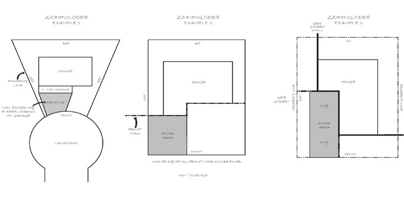
Figure 5-13
3. Multifamily and Mixed-Use Projects
Section titled “3. Multifamily and Mixed-Use Projects”Table 5.25 Parking Size, Location, and Configuration Standards for Multifamily Residential and Residential Portion of Mixed-Use Projects
Section titled “Table 5.25 Parking Size, Location, and Configuration Standards for Multifamily Residential and Residential Portion of Mixed-Use Projects”[AMENDED 1-13-2022]
This table has been split into multiple tables to comply with accessibility requirements. The following three tables shall all be referred to as a part of Table 5.26.
Parking Space Coverage and Assignment
| Standard | Minimum Requirement |
|---|---|
| General | - One parking space per unit shall be covered (carport or garage). As part of the Design Review or Development Plan Review, exceptions may be approved for affordable housing projects. - Permanent, assigned spaces must be standard spaces; a minimum of nine-foot wide by 19-foot long. |
| Multifamily Rental - Assignment | One space per unit shall be assigned. |
| Multifamily Ownership | - One parking space per unit shall be supplied by a single enclosed garage. - Automatic garage door required. |
Garage and Driveway Dimensions
| Standard | Minimum Requirement |
|---|---|
| General Size - If Provided | Minimum interior dimension of garages shall be 10 feet wide and 20 feet deep. Reductions in length and/or area of up to 10% of the standard may be considered administratively, if project demonstrates proposed garage will accommodate at least one standard sized vehicle. |
| Driveway Dimensions | When a carport or garage opens onto a side street yard, the driveway length shall be a minimum of 20 feet. When opening into an internal drive, the driveway shall be a minimum of 10 feet. |
Parking Location
| Standard | Minimum Requirement |
|---|---|
| Parking Space Visibility - Multifamily Ownership | Condominiums, townhouses, or similarly owned units where certain parking spaces are deeded, granted by easement, or otherwise permanently assigned, spaces shall be located to be visible from a window(s) of the unit to which it is assigned, whenever possible, unless such spaces are contained within a garage. The location and regulation of unassigned spaces shall be placed under the control of the project homeowners’ association. |
| Compact Spaces | Up to 50% of unassigned spaces may be compact spaces. Unassigned standard and compact spaces shall be evenly distributed throughout the project. |
| Parking Area Separation | Parking and paving directly touching against residential buildings shall be avoided. Paved surface parking areas shall be separated from the primary residential building by a minimum four-foot-wide walkway and/or a minimum seven-foot-wide landscape strip. |
| Tuck Under Parking | Tuck under and subterranean parking may be permitted for projects in the RD-20 or higher density zoning districts. Permitted, provided that parking access is restricted to an alley, the rear 40 percent of the site. |
| Parking Location - Multifamily Residential or Mixed-Use Development | At least one space for each residential unit shall be located on-site; other required parking spaces may be located off-site, subject to standards for off-site parking in Section 5.9.7. For Mixed-Use Developments, surface parking for commercial uses shall be located to the side or behind buildings, when feasible, and is discouraged at street corners, and in the front setback, but may be permitted subject to approval by the County at the time of Design Review. |
| Tandem Parking - Residential Unit Used As Family Day Care Home | Permitted per the standards of Section 5.9.3.D.1. |
| Tandem Parking - Multifamily Residential or Mixed-Use Project | Permitted subject to the following conditions:
|
| Off-site Parking Criteria | Per the standards of Section 5.9.7.A. |
| Parking Lot Screening | Per the Standards of Section 5.9.4.F. |
5.9.4. Improvement Requirements for Parking and Loading Areas
Section titled “5.9.4. Improvement Requirements for Parking and Loading Areas”[AMENDED 09-09-2022]
5.9.4.A. Drainage and Stormwater Quality Facilities
Section titled “5.9.4.A. Drainage and Stormwater Quality Facilities”Drainage facilities shall be provided in all parking areas adequate to handle the drainage requirements of the subject property in accordance with the County Improvement Standards, to alleviate the creation of flooding and drainage problems for the subject property or any surrounding properties. Stormwater quality control facilities in parking areas must satisfy the County’s stormwater management requirements and shall be designed in accordance with the current edition of the Stormwater Quality Design Manual for the Sacramento and South Placer Region.
- All surface water runoff shall be conveyed into a public right-of-way or storm drain, directed into planting areas, and/or a stormwater quality source control or treatment facility, as addressed in the standards that follow.
- Drainage Systems shall be provided in accordance with Section 9 of the County’s Improvement Standards.
- Runoff shall be treated per the requirements of the latest National Pollutant Discharge Elimination System (NPDES) permit prior to entering the public right-of-way or storm drain, and shall comply with the source control measures in the Stormwater Quality Design Manual for:
- Loading and unloading areas: to minimize the chance of spills and leaks of pollutants that may include toxic compounds, oils and greases, nutrients, suspended solids, fluid from delivery vehicles, and other contaminants, into the storm drain system;
- Wash areas in parking lot for vehicles and equipment: to minimize the chance of wash water that may contain oils and greases, metals, suspended solids, soluble organics, food waste, and/or detergents, from entering the storm drain system; and
- Waste and recycling storage areas in parking areas: to keep rain, run-off, and other site water from leaching pollutants into the storm drain system.
5.9.4.B. Surfacing Requirements
Section titled “5.9.4.B. Surfacing Requirements”-
Surfacing shall be provided for all parking and loading areas, aisles, and driveways, in accordance with specifications of the Sacramento County Engineering Division to eliminate dust and maintain a passable surface, strong enough to bear vehicle loads at all times. Alternative paving materials, such as pervious or porous pavements and light- colored or high-albedo surfaces are encouraged, per the requirements of the Stormwater Quality Design Manual and must be approved by the Planning Director and/or Engineering Division. The Engineering Division may specify an appropriate surface where a paved surface is not required.
-
Parking areas using porous pavements, excluding single-family dwellings or duplexes, shall be identified on parking area plans and provide documentation that the paving surface has been designed to support anticipated vehicle weights and traffic volumes that may result in maintenance issues such as surface cracking, crumbling, and erosion.
-
At a minimum, vehicle storage areas must consist of a gravel surface.
5.9.4.C. Marking of Parking Spaces
Section titled “5.9.4.C. Marking of Parking Spaces”Parking spaces shall be marked or maintained on the pavement in a visible manner; and when required, aisles, loading zones, pedestrian walks, crossings, fire lanes, and any other directional markings or signs shall be installed as permitted or required by the Sacramento County Engineering Division to ensure the proper utilization of space, adequate traffic flow, and general safety.
5.9.4.D. Bumper Curbs, Wheel Stops
Section titled “5.9.4.D. Bumper Curbs, Wheel Stops”To ensure the proper maintenance and utilization of these facilities, parking areas shall be designed so that a parked vehicle does not overhang required sidewalks, planters or landscaped areas. A permanent curb, bumper, wheel stop, or similar device shall be installed which shall be adequate to protect the required sidewalks, planters, and landscaped areas from vehicular overhang and to protect any structure from vehicular damage. If such protection is provided by means of a method designed to stop the wheel, rather than the bumper of the vehicle, the stopping edge shall be placed no closer than two feet from the edges of the required sidewalks, planter or landscaped areas and from any building, as illustrated in Figure 5-14. The Sacramento County Engineering Division may require other barrier curbs or wheel stops as deemed necessary to protect areas within or adjacent to the parking area from vehicular encroachment.
The innermost two feet of each parking space (between the curb and any planter or sidewalk or bumper or wheel stop) may remain unpaved, and may be planted with low ground cover, and added to any required or proposed landscaping to allow for bumper overhang and reduce impervious surfaces. This additional planting area is considered to be part of the parking space and may not count toward satisfying any landscaping requirement.
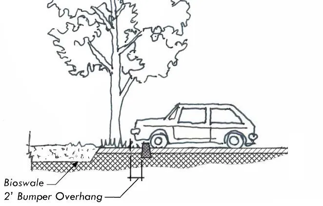
Figure 5-14: Example of Bumper Overhang
5.9.4.E. Additional Standards for Multifamily Residential and Mixed-Use Developments
Section titled “5.9.4.E. Additional Standards for Multifamily Residential and Mixed-Use Developments”[DELETED 09-09-2022]
5.9.4.F. Parking Area Screening
Section titled “5.9.4.F. Parking Area Screening”-
Parking lots and loading areas shall be screened from major public streets and adjacent residential uses with plants, trees, low walls, fences, berms, or grade changes that are a minimum of 30 inches tall. On that portion of any parking area located between the building line and the street where such a fence would interfere with visibility, the fence shall conform to the visibility requirements of the County’s Improvement Standards.
-
A six-foot-high wall and landscaping shall be provided adjacent to properties zoned for residential, interim residential, agricultural residential, interim estate, or agricultural uses, as identified in Section 5.2.4. The height of the fence shall be measured from the paved surface of the parking lot and may be modified with approval of a special development plan, where the appropriate authority finds that due to a significant difference in elevation between parcels, different screening requirements are necessary.
5.9.4.G. Parking Area Lighting
Section titled “5.9.4.G. Parking Area Lighting”- Lighting shall be constructed with full shielding and/or recessed to reduce light trespass to adjoining properties. Each fixture shall be directed downward and away from adjoining properties and public right-of-way, so that no light fixture directly illuminates an area outside of the site, and the light source is not visible from residential properties. New light fixtures, serving uncovered parking lots shall be full cut-off fixtures as defined by the Illuminating Engineering Society of North America. New light fixtures, installed for parking area canopies or similar structures, shall be recessed or flush-mounted, using flat lenses. This standard shall apply to existing businesses.
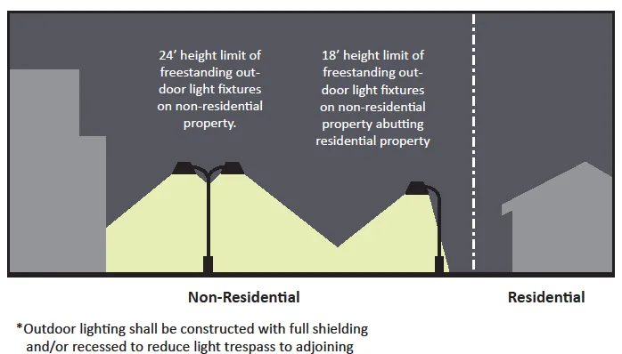
Figure 5-15 Shielding Provisions for Outdoor Lighting
-
The minimum lighting level shall be one foot-candle of maintained illumination on the parking surface during the hours of use between one-half hour before dusk and one-half hour after dawn.
-
Light Pole Locations. Light poles shall be located as follows:
- So as not to interfere with motor vehicle door opening, vehicular movements, or pedestrian travel paths;
- Away from trees that may obstruct the lighting; and
- In perimeter planters and landscape islands between rows of parking, but discouraged within end row planters, planting islands parallel to parking spaces, tree wells, and in the required clear path of pedestrian walkways.
5.9.4.H. Alternative Energy Systems
Section titled “5.9.4.H. Alternative Energy Systems”Alternative energy systems (solar and wind), including provision of solar panels on parking lot shade-structures or carports and solar lighting fixtures or parking meters are permitted as an accessory use in all non-residential, multifamily residential, and mixed-use parking areas, subject to Design Review approval.
5.9.4.I. Trash and Recyclable Receptacles.
Section titled “5.9.4.I. Trash and Recyclable Receptacles.”One trash and one recyclable receptacle shall be provided in parking areas with 40 vehicular parking spaces or more. An additional set of receptacles shall be required for 100 vehicular parking spaces or more.
5.9.4.J. Additional Standard for Large Parking Lots
Section titled “5.9.4.J. Additional Standard for Large Parking Lots”[AMENDED 09-09-2022]
-
Solutions that minimize the visual impact of residential and commercial driveways shall be used whenever possible, including shared driveways, alley access, or other design approaches that minimize the number and width of driveways and curb cuts.
-
Surface parking lots shall be divided into smaller, landscaped lots or courts with well-defined and safe pedestrian connections from the public street to the buildings, landscaping, shade trees, and lighting as needed. Refer to Parking Lot and Driveways Sections of the County-wide Design Guidelines for additional information.
- Parking rows in single or double set configurations shall be limited in length to no more than 270 feet (or approximately 30 adjacent parking spaces).
-
Reduction of parking stall sizes shall be allowed to be reduced by two (2) feet, provided the bumper overhang area is incorporated into adjacent sidewalk or landscape areas.
5.9.5. Parking Reductions
Section titled “5.9.5. Parking Reductions”This Section provides the criteria, measures, and requirements for the reduction of off-street parking. Automatic parking reductions and those reductions approved through Design Review, either individually or on a cumulative basis, shall not exceed the reduction provisions provided in Table 5.26. Greater overall parking reductions may be approved by a Special Development Permit. [AMENDED 07-11-2024]
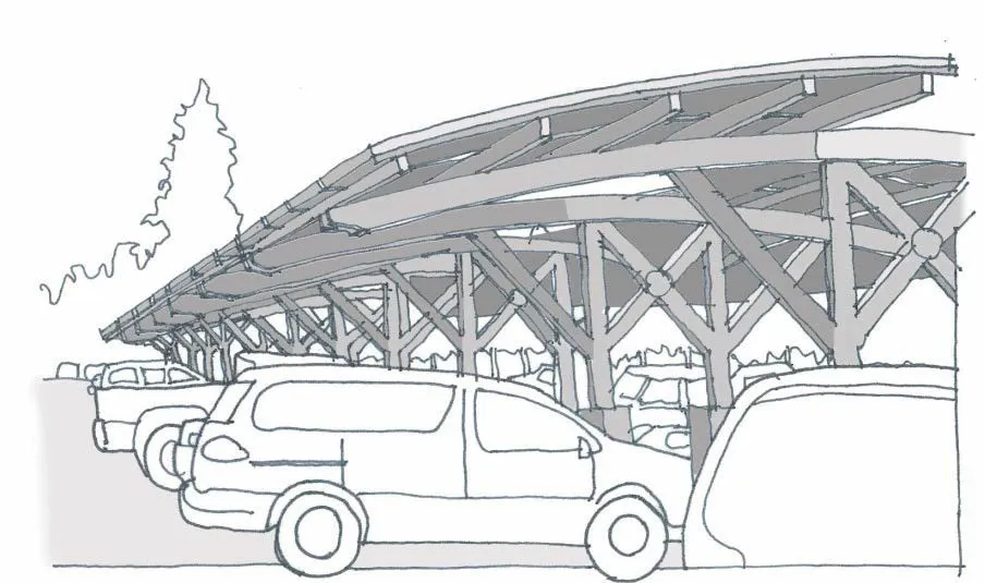
Figure 5-16 Solar Roof
Figure 5-17: Solar and Wind-Powered Lights
5.9.5.A. Criteria
Section titled “5.9.5.A. Criteria”[AMENDED 07-11-2024]
Required parking may be reduced through the Design Review process, subject to complying with the following requirements:
-
Project conditions such as proximity to frequent transit service; special characteristics of the population residing, working, or visiting the facility; or parking reduction measures in Section 5.9.5.C justify the reductions.
-
Parking demand generated by the project satisfies the requirements for the uses served and does not result in a negative impact on the supply of off-street parking in the surrounding area. Projects utilizing the provisions of Section 5.9.5.C.1.b Transit Accessibility or Section 5.9.5.C.4 Places of Worship Affiliated Housing Parking Reductions are not subject to this finding.
-
Parking Management Plan. A parking management plan may be required as evidence or documentation necessary to demonstrate the conditions that warrant a parking reduction and should include:
- Parking demand information that documents the need for fewer spaces (e.g. sales receipts, records of customer visits, information on parking use for similar facilities in the region, etc.);
- Floor plans indicating the typical uses of the buildings; and
- Programs that may be implemented that would reduce parking demand.
-
If a parking reduction is based on specified uses, then those uses may not be replaced with an alternative use unless either additional parking is provided or a finding can be made that the alternative use has an equivalent or lower parking demand.
5.9.5.B. Review of Parking
Section titled “5.9.5.B. Review of Parking”In addition to the allowed parking reduction measures in Section 5.9.5.C, parking may also be reduced upon request during Design Review, provided the project proponent can demonstrate the parking demands would be less, or agreements with owners of adjacent property for shared parking are obtained.
-
The project proponent shall submit with the request documentation to demonstrate that unusual conditions warrant a parking reduction, such as:
- Number of bedrooms per unit, considering rooms that could logically be converted to bedrooms.
- Whether the parking for individual units is in open parking spaces in lieu of providing parking in garages or spaces restricted for the use of tenants only.
- That the reduction would preserve existing landscaping and open space that would otherwise have to be removed to provide additional parking.
- Multiple use of a parking area by uses having peak parking demands which occur at different times.
- Floor plans which indicate that the floor area devoted to customer or employee use is less than typical for the size building proposed.
- Other programs that will be implemented by the developer or tenant(s) which will result in a demand for parking at the site which is less than would otherwise occur, such as the provision of monetary incentives to employees who regularly utilize public transit or participate in a carpool or vanpool.
-
Parking reductions exceeding the maximums specified in this Section, or modifications of improvement requirements, may also be granted by the County Planning Commission, the Board of Supervisors, or the Zoning Administrator whenever such reduction or modification is considered in conjunction with a Special Development Permit, or is heard in conjunction with a Rezoning, Conditional Use Permit, or Variance by the appropriate authority.
-
The appropriate authority may require as a condition of approval of the parking reduction the recordation of agreements or covenants, prior to issuance of a building permit, which assure that appropriate programs are implemented for the duration of the parking reduction.
5.9.5.C. Parking Reduction Measures
Section titled “5.9.5.C. Parking Reduction Measures”[AMENDED 07-11-2024]
The number of off-street parking spaces may be reduced administratively (staff level) as provided in Table 5.26 subject to meeting the criteria in Section 5.9.5.A above and the following provisions.
Table 5.26 Maximum Administrative Parking Reductions
Section titled “Table 5.26 Maximum Administrative Parking Reductions”[AMENDED 07-11-2024]
This table has been split into multiple tables to comply with accessibility requirements. The following two tables shall all be referred to as a part of Table 5.26.
The items below can be combined up to a maximum of a 25% administrative parking reduction.
| Type | Maximum Reduction |
|---|---|
| Shared Parking | 25% |
| Proximity to Class II or Class III bike lanes | 10% |
| Transit Supportive Plazas | 10% |
| Tree Preservation | 10% (not more than six spaces total) |
| Bicycle Parking (non-required) | 10% |
| Provision of Electric Vehicle Charging Station above the number of spaces required by the California Green Building Standards Code | 2:1 |
| Preferential Parking for Carpool/Vanpool | 5% |
| Shower/Locker Facilities | 5% |
| Transit Waiting Shelter | 10% |
| Motorcycle Parking | 1:1 (one space can be reduced for each motorcycle space provided) |
| Available on-street parking | 1:1 (one space can be reduced for each available on-street parking) |
Allowable Administrative Parking Reductions in excess of 25% (cannot be combined with other administrative parking reductions listed above)
| Type | Maximum Reduction |
|---|---|
| Transit Accessibility | 100% |
| Places of Workship Affiliated Housing | 50% (of required parking for place of worship) |
1. Multifamily, Mixed-Use, and Non-Residential Projects
Section titled “1. Multifamily, Mixed-Use, and Non-Residential Projects”a. Shared Parking
Section titled “a. Shared Parking”Where two or more uses on the same site are able to share the same parking spaces, because their parking demand occurs at different times, a parking reduction may be granted, subject to approval of a parking demand study, using the Urban Land Institute’s accepted ratios and/or other appropriate source, approved by the Planning Director. The Planning Director may require a parking management plan, conducted by a licensed traffic engineer or other traffic professional. Off-site parking may also be considered for shared parking as described in Section 5.9.7.C.
b. Transit Accessibility.
Section titled “b. Transit Accessibility.”Development proposed within one-half mile of an existing or planned major transit stop as defined in CA PRC §21064.3 is not required to provide parking subject to the following:
- For purposes of this section, a planned stop is a major transit stop that is scheduled to be completed within the planning horizon of the adopted Sacramento Area Council of Governments Metropolitan Transportation Plan/Sustainable Community Strategy (SACOG MTP/SCS) and meets the service requirements listed in CA PRC §21064.3.
- Minimum automobile parking requirements may be imposed on a development project if the lack of parking would have a substantially negative impact, supported by a preponderance of the evidence in the record, on any of the following:
- The County’s ability to meet its share of the regional housing need in accordance with CA GOV §65584 for low- and very low-income households;
- The County’s ability to meet any special needs housing for the elderly or persons with disabilities identified in the analysis pursuant to CA GOV §65587(a)(7); or
- Existing residential or commercial parking within one-half mile of the project.
- Regardless whether one of the findings in Section 5.9.5.C.1.b.ii. can be made, the following housing development projects are still not required to provide parking if located within one-half mile of a major transit stop, as defined:
- The development dedicates a minimum of 20 percent of the total number of housing units to very low, low-, or moderate-income households, students, the elderly, or persons with disabilities.
- The development contains fewer than 20 housing units.
- The development is subject to parking reductions based on the provisions of any other applicable law.
- This Section shall not apply to the following:
- Projects subject to a contractual parking agreement with a public agency executed before January 1, 2023 where all provided parking is shared with the public.
- Hotels, motels, bed and breakfast inns, or other transient lodging uses.
- Employee and other worker parking for event centers.
- Event centers located within one-half mile of a transit stop, as defined, are not required to provide customer parking pursuant to this Section but must provide parking for employees and other workers pursuant to Section 5.9.
- Eligible projects shall provide the required electric vehicle spaces and space accessible to persons with disabilities based on the number of spaces typically required for the proposed use to the application California Building Code as referenced in County Code Chapter 16.
- Eligible projects that voluntarily provide parking provide parking spaces for car share, carpool, and vanpool vehicles pursuant to Section 5.9.6.D.2.
c. Proximity to Class II or Class III bike lanes.
Section titled “c. Proximity to Class II or Class III bike lanes.”For all projects within one-quarter mile (1,320 linear feet) to Class II or Class III bike lanes, a maximum 10 percent reduction in parking requirements may be granted when the reviewing authority determines that the parking management plan submitted by the applicant justifies the parking reduction.
d. Transit-supportive Plazas.
Section titled “d. Transit-supportive Plazas.”On sites where at least 20 parking spaces are provided and a transit shelter is required on-site, transit supportive plazas may substitute for up to 10 percent of the required parking spaces on the site, subject to the following standards:
- The plaza must be at least 300 square feet in area and shaped so that a 10-foot by 10-foot square will fit entirely in the plaza;
- The plaza must include a lighted, transparent, and weather-protection shelter approved by Regional Transit, and a bench or other sitting area with at least five linear feet of seating;
- The plaza must include landscaping on at least 10 percent, but no more than 25 percent of the transit-supportive plaza. This landscaping is in addition to any other required landscaping or screening for parking areas in the Code; and
- The owner of the plaza must record a public access easement that allows public access to the plaza.
e. Tree Preservation.
Section titled “e. Tree Preservation.”Minimum parking may be reduced by one parking space for each tree 12 inches in diameter and larger that is preserved. A maximum of two parking spaces or 10 percent of the total required parking may be reduced, whichever is greater. However, required parking may not be reduced below six spaces under this provision.
f. Provision of Bicycle Parking.
Section titled “f. Provision of Bicycle Parking.”Bicycle parking may substitute for up to 10 percent of required parking. For every three non-required bicycle parking spaces that meet the short or long-term bicycle parking requirements, the motor vehicle parking requirement is reduced by one space. Existing parking may be converted to take advantage of this provision.
g. Provision of Electric Vehicle Charging Station.
Section titled “g. Provision of Electric Vehicle Charging Station.”Each electric vehicle charging station above the minimum required by the California Green Building Standards Code shall be permitted to substitute for two vehicular parking spaces. The area needed for charging equipment shall count toward meeting the parking space requirements.
2. Multifamily Residential and Mixed-Use Housing
Section titled “2. Multifamily Residential and Mixed-Use Housing”- Parking reductions for multifamily residential and the residential portion of mixed-use projects within one-quarter mile of transit shall be permitted, as provided in Table 5.26, “Maximum Staff Level Parking Reductions.”
- For affordable multifamily housing projects and senior housing projects, parking requirements may be reduced, subject to demonstration that on-site management can accommodate the parking needs of persons or families occupying individual units.
3. Trip Reductions for Large Non-Residential or Employment Centers.
Section titled “3. Trip Reductions for Large Non-Residential or Employment Centers.”Some trip reduction requirements, described in Section 5.9.6, qualify for a reduction in parking requirements, subject to the criteria and minimum requirements for trip reduction measures that follow.
4. Places of Worship Affiliated Housing Parking Reductions.
Section titled “4. Places of Worship Affiliated Housing Parking Reductions.”Replacement parking shall not be required when a place of worship removes up to 50 percent of the existing or required parking spaces (excluding any required electric vehicle or accessible parking spaces) to build affiliated housing subject to the following criteria:
- The housing development project is located on one or more contiguous parcels that are owned entirely, whether directly or through a wholly owned company or corporation, by the place of worship.
- The housing development project qualifies as being near collocated religious-use parking spaces by being any of the following:
- Located one or more parcels that collectively contain religious-use parking spaces.
- Located adjacent to a parcel owned by the place of worship that contains religious-use parking spaces.
- Located on one or more parcels separated by no more than 0.1 miles from a parcel owned by the place of worship that contains religious-use parking spaces.
- The housing development project qualifies for a density bonus under CA GOV §65915 and as allowed pursuant to Section 6.5.4.
- A minimum of one parking space shall be required for each dwelling unit and any required electric vehicle or accessible spaces required by the California Building Code for the housing development.
5.9.6. Trip Reduction Requirements
Section titled “5.9.6. Trip Reduction Requirements”Trip reduction requirements ensure large non-residential development projects provide adequate alternative transportation facilities or programs which serve to reduce trips and parking demand. In return, some trip reduction measures may qualify for a reduction in vehicle parking requirements, according to the provisions in Section 5.9.6.D.
5.9.6.A. Applicability
Section titled “5.9.6.A. Applicability”-
Any commercial, industrial, institutional, or other use which is expected to employ 200 or more persons, as determined by either actual employee projections or equivalent development size, pursuant to Section 5.9.6.C, and
-
Any existing facility or development which increases its gross floor area and, after such increase, exceeds the minimum equivalent development size described in Section 5.9.6.C.
-
The Planning Director may, if projected traffic conditions warrant, apply the provisions of this Section to developments smaller than those specified in Section 5.9.6.C.
5.9.6.B. Exempt Projects
Section titled “5.9.6.B. Exempt Projects”Notwithstanding any other provisions of this Code, the following uses and activities shall be specifically exempt from the provisions of this Section.
-
Development projects expected to employ fewer than 200 persons.
-
Temporary construction activities on any affected project, including activities performed by engineers, architects, contractors, subcontractors, and construction workers.
5.9.6.C. Equivalent Development Size
Section titled “5.9.6.C. Equivalent Development Size”For the purpose of this Section, the following minimum development sizes shall be considered equivalent to the 200-employee threshold described in subsection A. Minimum development size shall be based on the size of the overall development, not a particular phase or building within the development when determining if Sections 5.9.6.D through 5.9.6.H apply.
Table 5.27 Equivalent Development Size
Section titled “Table 5.27 Equivalent Development Size”| Type of Use | Minimum Development Size (in sq. ft.) Equivalent to 200 Employees |
|---|---|
| Office (excluding medical) | 50,000 |
| Industrial Office Park (MP) | 60,000 |
| Hospital and Medical Offices | 80,000 |
| Commercial | 100,000 |
| Light Industrial (M-1) | 95,000 |
| Heavy Industrial (M-2) | 130,000 |
| Mixed or Multiple Uses | To be calculated based on the employee equivalent of the square footage or areas devoted to each use |
5.9.6.D. Trip Reduction Measures
Section titled “5.9.6.D. Trip Reduction Measures”- Passenger Loading Areas. Public parking areas for major development projects, as defined in Section 5.9.6.A, shall designate a passenger loading area or areas for embarking and disembarking passengers from ridesharing vehicles.
- Such passenger loading areas shall be located at the point(s) of pedestrian access from the parking area to the adjacent building, or buildings, and shall be designed in such a manner that vehicles waiting in the loading areas do not impede vehicular circulation in the parking area or pedestrian access to the building entry.
- The passenger loading areas shall be designed as a turn out as indicated by Figure 5-18, and shall be large enough to accommodate the number of waiting vehicles equivalent to one-half percent of the required parking for the project or building that it serves.
- Passenger-loading areas may be designed with porous pavements, in accordance with the surfacing requirements in Section 5.9.4.B.
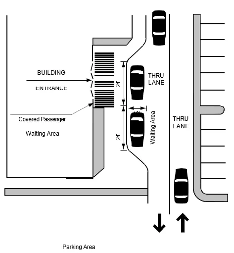
Figure 5-18 Passenger Loading Area Design
-
Preferential Parking Spaces for Carpool and Vanpool Vehicles. All major development projects, as defined in Section 5.9.6.A, shall reserve and designate at least 10 percent of the employee parking spaces for the project for ridesharing vehicles by marking such spaces “Carpool/Vanpool Only.” The number of preferential parking spaces must be increased above 10 percent of the employee parking as necessary to accommodate all legitimate carpools and vanpools.
- Such spaces shall be clustered near the building entrance(s), covered, shaded, or in some other obvious way, be demarcated as preferential.
- For purposes of this Section, the factors listed in Table 5.28 shall be used to determine the number of employee parking spaces.
Table 5.28 Employee Parking Factor
Section titled “Table 5.28 Employee Parking Factor”Type of Use Percent of Total Parking Devoted to Employee Parking Office (excluding medical) 70% Industrial Office Park (MP) 70% Hospital and Medical Offices 50% Commercial 30%
- Parking Reduction Measure. Office, institutional, mixed-use, or industrial developments which guarantee preferred parking spaces (e.g., covered, shaded, or near building entrance) to employees who participate regularly in a carpool or vanpool may reduce their parking requirement by one vehicle space for every one space which is marked and reserved for carpools/vanpools at a preferred location. Maximum reduction is five percent of required parking or up to five spaces.
-
Shower and Locker Facilities. All development projects above the minimum development size thresholds identified in this Section shall provide shower and locker facilities for use by employees or tenants who commute to the site by bicycle or walking. Such facilities shall be clearly indicated on all development/improvement plans.
- The use of such facilities shall be provided at no cost to the user, except that at any development where a fee is charged for employee parking, the use of shower and locker facilities may be assessed at a charge not to exceed one- half the charge for employee parking.
- One shower and eight lockers with minimum dimensions of 12 inches by 18 inches by 36 inches shall be provided for each 200 employees or fraction thereof, based on the equivalent development size data in Section 5.9.6.C.
- The design and/or management of the shower and locker facilities shall provide for access by both male and female employees (i.e., there is not a requirement for separate facilities).
- The shower and locker facilities must be located convenient to one another and should be located near the employee bicycle parking facilities whenever possible.
- Parking Reduction Measure. Developments with 100 or more employees may reduce their parking requirement by five percent by providing shower and clothing locker facilities for use by employees or tenants who commute by bicycle or walking, in accordance with the requirements in subsections 5.9.6.D.3.a through d.
-
Transit Waiting Shelters
- Prior to the issuance of any building permit or approval of any improvement plans for any major development project, the property owner or project proponent shall sign and record an agreement with the County of Sacramento to provide for any easement(s) and/or construct a concrete foundation, and provide an electrical connection necessary to accommodate placement of a transit waiting shelter, when required. The determination as to whether a transit waiting shelter(s) easement and/or concrete foundation, and electrical connection is needed shall be made by the Planning Director after direct consultation with the public agency which provides, or is authorized by law, to provide transit services to the general public in the project area. This Section shall not be interpreted to require the provision of an easement and/or concrete foundation, or electrical connection, at a distance of more than 100 feet from the perimeter of the project site.
- Parking Reduction Measure. Refer to parking reductions for related transit- supportive plazas, in Section 5.9.5.C.1.c.
5.9.6.E.
Section titled “5.9.6.E.”[DELETED]
5.9.6.F. Requirement for Transportation System Management Plan
Section titled “5.9.6.F. Requirement for Transportation System Management Plan”In addition to the other requirements of this Section, the Director shall be authorized to require the applicant, developer, or property owner of a development project to prepare a comprehensive Transportation System Management Plan, pursuant to Section 5.9.6.H, in conjunction with any application for a Rezone, Conditional Use Permit, Special Development Permit, Development Plan Approval, Development Agreement, or Variance, or a request for a building permit if the Director finds:
-
That the proposed project has the potential to increase local and/or area wide traffic congestion with an accompanying deterioration in air quality on a project specific or cumulative basis; or
-
That due to the proposed project’s location and/or operational characteristics, development and implementation of a Transportation Systems Management Plan would have the potential for significantly reducing peak hour commute trips.
Similarly, for any development project which is expected to employ 500 or more persons, as determined by Section 5.9.6.C, the Director shall require the applicant to prepare a Transportation System Management Plan, pursuant to Section 5.9.6.I, in conjunction with any application for a Rezone, Conditional Use Permit, Special Development Permit, Development Plan Approval, Development Agreement, Variance, or a request for a building permit.
5.9.6.G. Contents of Transportation System Management Plan
Section titled “5.9.6.G. Contents of Transportation System Management Plan”A Transportation System Management Plan, as required by Section 5.9.6.H, is intended to describe the full set of facilities and services to be provided by a development project which is proposed to reduce the number of employee commute trips to the site. The plan shall include an exhibit indicating the location of trip reduction facilities and a written description of all trip reduction facilities and services. Facilities and services contained in the plan shall include those described in Sections 5.9.6.D through 5.9.6.E, plus any other facilities, amenities, or services intended to encourage carpool, vanpool, transit, bicycle, or pedestrian commuting. Such additional facilities and services may include, but are not limited to:
-
Bikeway linkages to establish bicycle routes, transit routes, or adjacent residential and commercial areas.
-
Walkways and other pedestrian linkages to nearby transit stops.
-
Transit stations, timed transfer stops, transit shelters, on site sale of transit passes/tickets and possible transit subsidies.
-
Community park-and-ride lots.
-
Provision of an employee transportation coordinator.
- On site at 1,000 or more employees
- Full time at 2,000 or more employees
-
Preferential parking program.
-
Alternative commute mode information services.
-
Work schedule management program.
-
Commuter matching services.
-
Bicycle facilities including storage, showers and lockers.
-
Provision of an owners/tenants association with responsibility for ongoing implementation of the plan including any necessary funding.
5.9.6.H. Review of Transportation System Management Plan
Section titled “5.9.6.H. Review of Transportation System Management Plan”For any development project which is required to prepare a Transportation System Management Plan pursuant to Section 5.9.6.F, the appropriate authority shall consider the plan during its review and consideration of the application and may require the construction of any or all facilities contained in the plan as a condition of approval of the project.
5.9.6.I. Binding Agreements
Section titled “5.9.6.I. Binding Agreements”The owners/tenants association, or the property owner(s) on behalf of a future owners/tenants association, shall sign and record an agreement with the County of Sacramento obligating the association to implement all the requirements of the Transportation Systems Management Plan and to provide any necessary funding to carry out the provisions of the plan.
5.9.7. Off-Site Parking Requirements
Section titled “5.9.7. Off-Site Parking Requirements”Where use of off-site parking is authorized to satisfy the parking requirements of this Chapter, parking may be provided by one or more alternatives in this Section.
5.9.7.A. Off-site Parking Criteria
Section titled “5.9.7.A. Off-site Parking Criteria”Off-site parking alternatives may be permitted, subject to approval during the Design Review process and compliance with the following criteria.
-
Parking Distance. Off-site parking spaces must be located no further than 1,200 feet from the primary entrance to a site and must provide a well-marked, safe, traversable pedestrian route, over and along publicly accessible streets or walkways, between the parking site and the buildings or structures they serve. The reviewing authority may waive this distance limitation for valet services, employee parking, or assurances that van or shuttle service will be in operation between off- site parking areas and their principal uses.
-
Parking Requirements. All off-site parking spaces shall be subject to the same standards for access, configuration, location, dimensions, etc. as is required for off- street parking in this Chapter. In addition, the following standards also apply.
- Wayfinding signs clearly directing visitors and employees to off-site parking areas shall be placed and maintained by the property owner at the principal site location. Signs at off-site parking locations should specify which uses or tenants the parking area serves and any parking restrictions applicable to the land use.
-
Off-site Parking Agreement. An agreement providing for the use of the off-site parking area, executed by the owner/tenants or other parties involved must be approved and guarantee the long term availability of the parking, commensurate with the uses they serve. Off-site parking privileges will continue for as long as this binding agreement remains in force.
-
On-street Parking. Additionally, on-street parking may count toward satisfying off- street parking requirements for commercial service and retail uses and visitor parking at a 1:1 ratio.
5.9.7.B. Collective Provision of Parking
Section titled “5.9.7.B. Collective Provision of Parking”Collective provision of parking may be approved where appropriate locations are identified for non-residential and mixed-use districts serving two or more buildings or uses, in accordance with the following requirements.
-
Total parking spaces provided shall not be less than the sum of the requirements for the individual uses served, as identified in this Chapter, unless an exception is granted through a Special Development Permit.
-
Parking facilities on adjoining lots may share access and driveways, subject to a recorded covenant for the properties on which the facilities are located.
-
A covenant or agreement establishing the long-term availability, maintenance, and use of the collective parking area(s) shall be executed by all parties involved and approved by the County. Collective parking privileges will continue in effect for as long as the parking agreement remains in force. If the collective parking agreement lapses or is no longer valid, then parking must be provided for each use on-site, as required by this Chapter.
-
Where collective parking areas are located off-site from the served land use, the criteria in Section 5.9.7.A shall apply.
5.9.7.C. Shared Parking
Section titled “5.9.7.C. Shared Parking”Shared parking allows reduction of parking spaces for any site development or adjacent parcel proposing two or more land uses where the hours of operation for the uses allows shared use of parking spaces to occur without conflict. Parking reductions are permitted, subject to the following standards.
-
A shared parking study is provided, using Urban Land Institute (ULI) accepted ratios or an equivalent source to be approved by the Planning Director as part of the Design Review application. The application shall clearly define and achieve project shared parking, accompanied by the following findings:
- Land uses / buildings participating in the shared parking program demonstrate different parking demands;
- Parking spaces designated for shared parking are not otherwise committed to satisfying parking requirements for some other use at similar times;
- Spaces comply with the distance and other criteria, identified for off-site parking in 5.9.7.A.
-
The parking study shall use the following methodology:
- Base parking requirements shall be calculated as the sum of the requirements for each land use, per the requirements of this Chapter;
- When different land uses utilize a common parking area, the total number of spaces required to support the collective uses will be determined by parking profiles using ULI accepted practices or an equivalent source approved by the Planning Director, rather than by peak ratios for each land use;
- Review and approval of the parking studies shall be at the discretion of the approval authority.
-
A shared parking agreement establishing the long-term availability, maintenance, and spaces required, commensurate with the use of the facility, shall be approved and recorded by the County. Shared parking privileges will continue in effect for as long as the agreement remains binding on all parties. If a shared parking agreement lapses or is no longer valid, then parking must be sufficiently provided for each use, as required by this Chapter.
5.9.7.D. “Park Once” Program
Section titled “5.9.7.D. “Park Once” Program”Establishment and participation in a “Park Once” program may be used to comply with off-street parking requirements in accordance with the following standards.
-
A “park once” parking strategy may be established for mixed-use or non-residential sites in a County-owned parking lot, parking assessment district, or other areas where opportunities exist to provide a centralized parking area, within walkable distance of adjoining businesses and uses that encourages patrons to park once and walk to their destinations.
-
A parking management plan shall be required to define the parking needs of participating sites or areas, proposed uses and/or programs, site or parking characteristics, including walkability, transit opportunities, and other factors that support the development of the program.
-
A covenant or agreement establishing the long-term availability, maintenance, and use of the collective parking area(s) shall be executed by all parties involved and approved by the County. Collective parking privileges will continue in effect for as long as the parking agreement remains in force. If the collective parking agreement lapses or is no longer valid, then parking must be provided for each use on-site, as required by this Chapter.
5.9.8. Motorcycle Parking Requirements
Section titled “5.9.8. Motorcycle Parking Requirements”As defined in this Code, motorcycle parking includes parking for all two-wheeled motorized vehicles, including scooters, mopeds, and similar vehicles.
5.9.8.A. Motorcycle Parking Requirements
Section titled “5.9.8.A. Motorcycle Parking Requirements”Parking areas with 40 or more automobile parking spaces must provide motorcycle parking according to the following standards.
-
One motorcycle space must be provided for each 40 automobile parking spaces. For each one required motorcycle space provided, the number of required vehicle spaces is reduced by one.
-
Motorcycle parking spaces shall be a minimum dimension of four feet by seven feet, with up to four motorcycle spaces permitted for each vehicular space.
5.9.9. Bicycle Parking Requirements
Section titled “5.9.9. Bicycle Parking Requirements”5.9.9.A. Bicycle Parking Facility Classifications
Section titled “5.9.9.A. Bicycle Parking Facility Classifications”Bicycle parking facilities and terms used in this Section are defined as follows:
-
Class I Bicycle Facility. Includes the following: a) an enclosed box with a lockable storage compartment, or bicycle locker, accessible only to the bicycle owner/operator; or b) a locked room in a structure designated for storing and securing bicycles.
-
Class II Bicycle Facility. A stationary bicycle rack designed to secure the frame and both wheels of the bicycle, where the bicyclist supplies only the locking device.
-
Class III Bicycle Facility. A stationary bicycle rack, typically with a cement slab and vertical metal bar, where the bicyclist supplies a padlock and chain or cable to secure the bicycle to the stationary object.
-
Short-Term Parking. Easily accessible bicycle spaces provided for the convenience of shoppers, customers, and other visitors, visiting for a short duration of less than two hours. Short-term bicycle parking should be in proximity to the main entrance of a building, within 100 feet and visible to pedestrian and bicyclists; or located in a common bicycle parking facility along a pedestrian access route.
-
Long Term Parking. Bicycle parking in a secure and weather-protected place to serve employees, students, residents, commuters, and others who generally stay on the site for several hours. Long-term parking does not have to be provided on-site, but should be within a reasonable distance, no greater than 400 feet from the site, to encourage bicycle use. Bicycle parking must be provided in racks or lockers.
5.9.9.B. Minimum Bicycle Parking Requirements
Section titled “5.9.9.B. Minimum Bicycle Parking Requirements”[AMENDED 07-16-2020]
Bicycle parking spaces shall be provided in compliance with the minimum requirements in Table 5.29 and the standards in Section 5.9.9.C.
Table 5.29 Bicycle Parking Facility Requirements [1]
Section titled “Table 5.29 Bicycle Parking Facility Requirements [1]”| Use | Long-Term Bicycle Spaces | Short-Term Bicycle Spaces | Long-Term Bicycle Parking Facility Class | Short-Term Bicycle Parking Facility Class |
|---|---|---|---|---|
| All commercial, mixed-use, and service uses not otherwise listed | One bicycle space for every 30 vehicle spaces required or two spaces, whichever is greater | One bicycle space for every 30 vehicle spaces required or two spaces, whichever is greater | Class I lockers, or Class II racks in an enclosed lockable area | Class II or Class III racks |
| Dinner restaurants, cocktail lounges | One bicycle space for every 50 vehicle spaces required or two spaces, whichever is greater | One bicycle space for every 30 vehicle spaces required or two spaces, whichever is greater | Class I lockers, or Class II racks in an enclosed lockable area | Class II or Class III racks |
| Industrial | One bicycle space for every 50 vehicle spaces required or two spaces | Two Spaces | Class I lockers, or Class II racks in an enclosed lockable area | Class II or Class III racks |
| Office and institutional uses within commercial and industrial zoning districts | One bicycle space for every 30 vehicle spaces required or two spaces, whichever is greater | One bicycle space for every 60 vehicle spaces required or two spaces, whichever is greater | Class I lockers, or Class II racks in an enclosed lockable area | Class II or Class III racks |
| Institutional uses in other zoning districts | [2] | [2] | [2] | [2] |
| Multiple Family | For multifamily housing, a minimum of one bicycle parking space per unit shall be provided on-site, with guest bicycle parking spaces provided at one space per 10 units on-site. | For multifamily housing, a minimum of one bicycle parking space per unit shall be provided on-site, with guest bicycle parking spaces provided at one space per 10 units on-site. | Class I or Class II racks shall be located close to and with direct access to multifamily building entries. Bicycle parking for guests shall be clustered in common areas for easy convenience. | Class I or Class II racks shall be located close to and with direct access to multifamily building entries. Bicycle parking for guests shall be clustered in common areas for easy convenience. |
[1] Where the application of the above table results in the requirement for a fraction of a bicycle parking space, such a space need not be provided unless the fraction exceeds 50 percent.
[2] Bicycle parking shall be determined at the time of issuance of a Conditional Use Permit, but shall require a minimum of two long-term (Class I lockers, or Class II racks in an enclosed lockable area) and two short-term (Class II or Class III) spaces. For institutional uses that do not require a Use Permit the requirements for institutional uses in commercial zoning districts shall apply.
5.9.9.C. Design Standards
Section titled “5.9.9.C. Design Standards”Bicycle parking facilities shall be installed in a manner which allows adequate spacing for access to the bicycle and the locking device when the facilities are occupied. Each bicycle parking space shall be at least two feet wide by six feet long, with a five foot maneuvering space behind the bicycle. The facilities shall be located on a hard, dust free surface, preferably asphalt or concrete slab and/or may also be mounted on a flat wall surface, with appropriate maneuvering space behind the bicycle.
5.9.10. Truck Loading and Unloading Areas
Section titled “5.9.10. Truck Loading and Unloading Areas”5.9.10.A. Quantity Receivers, Shippers
Section titled “5.9.10.A. Quantity Receivers, Shippers”All retail and wholesale stores, warehouses, supply houses, buildings devoted to manufacturing trade, hotels, hospitals or other buildings where large amounts of goods are received or shipped shall provide loading and unloading space adequate to handle the volume and frequency of truck traffic to the building or shopping center. The minimum number of spaces shall be determined in accordance with the estimated volume of truck traffic and loading requirements. Each required loading space shall be not less than 10 feet wide, 35 feet long, and 14 feet high, exclusive of driveways.
5.10. SIGN REGULATIONS
Section titled “5.10. SIGN REGULATIONS”5.10.1. General Provisions
Section titled “5.10.1. General Provisions”5.10.1.A. Real Estate Signs
Section titled “5.10.1.A. Real Estate Signs”Real estate signs advertising the particular property on which the sign is located are authorized in all zones provided the following standards are met.
-
Number of On-Site Signs. Not more than one for lease or one for sale sign is to be placed on the property (one Assessor’s parcel), except that property bounded by more than one street shall be allowed one for sale sign or one for lease sign facing each street, to a maximum of no more than two signs per property.
-
Size and Location. The size and location shall be determined according to Table 5.30.
Table 5.30 Developed/Improved Property
Section titled “Table 5.30 Developed/Improved Property”| Zoning Districts | Maximum Sign Area (sq. ft.) | Required Setback from Dedicated Public Street Right-of-Way (ft.) | Required Setback from Dedicated Public Street Right-of-Way with PUPFs (ft.) |
|---|---|---|---|
| M-1, M-2, MP, BP, SC, LC, GC, AC, TC, C-O, CC, C-1, C-2, NMC, CMC, CMZ | 32 | 10 | 16 |
| AG-160, AG-80, AG-40, AG-20, UR, IR, RR, A-80, A-20 | 24 | 25 | 31 |
| RD-1, RD-2, RD-3, RD-4, RD-5, RD-7, RD-10, RD-20, RD-30, RD-40; MHP, RM-2, Interim Estate Zones, Interim Residential Zones | 5 | 10 | 14 |
| SPA, DW | [1] | [1] | [1] |
| Undeveloped/Unimproved Property in any Zone | 24 | 25 | 31 |
[1] Area and setback requirements in special zoning districts shall be determined by the type of use allowed and shall be consistent with the above standards.
-
Illumination. Signs shall not be illuminated.
-
Sign Attachment. Signs shall be permanently attached as follows:
- Permanently attached to structures.
- Permanently attached to ground except that signs on skids are allowed in developed parking areas and sites under construction. All skids and framing for sign shall be painted either white or earth tone colors.
-
Height. If attached to buildings, the sign shall not exceed the roof line or parapet wall of the building. If freestanding, the maximum height is six feet except when the site grade is lower than the grade at the right-of-way line, sign height may be increased so the bottom of the sign panel is equal to the elevation of the grade at the right-of-way line. In no case shall a sign exceed a total height of 10 feet.
-
Portable Off-site Directional Signs. Notwithstanding the prohibition of Section 5.10.1.I, portable off-site directional signs may be utilized in conjunction with open house real estate sales activity provided that the directional portable signs do not exceed an overall size of nine square feet including support, do not exceed a height of 2.5 feet, and are not located within the street right-of-way. Signs may be on display only during those hours when the dwelling is open for public inspection.
-
Time Limitation. Real estate signs shall be removed within 30 days after sale of the property or immediately upon being leased.
-
Portable off-site directional signs located within County right-of-way are prohibited and may be removed/disposed of by County personnel without notice.
-
Any sign in violation of any provision herein may be removed by County personnel without notice.
5.10.1.B. Temporary Construction Signs
Section titled “5.10.1.B. Temporary Construction Signs”Where a building is under construction, temporary signs are authorized in all zones identifying the project architect, landscape architect, contractor, builder, proposed business, or lender, provided:
-
There is no more than one such on-site sign.
-
The sign shall not exceed 32 square feet in area.
-
The sign is not illuminated.
-
The sign is set back from each street right-of-way not less than 10 feet (If PUPF easement: 14 feet in residential and agricultural-residential zoning districts, and 16 feet in all other zoning districts) from the street right-of-way.
-
If attached to the building, the sign shall not exceed the roof line or parapet wall of the building. If freestanding, the maximum height is 10 feet.
-
The sign is stationary.
-
The sign is removed at the time of final inspection of the job.
5.10.1.C. Political, Religious and Civic Campaign Signs
Section titled “5.10.1.C. Political, Religious and Civic Campaign Signs”Such signs are authorized in any zone for a period not to exceed 90 days provided:
-
Such signs are removed within 10 days following the conclusion of the campaign.
-
Said signs shall not be displayed in the Scenic Corridors as specified in this Chapter. Otherwise, signs shall not be within five feet of the side property lines and shall be set back from the street right-of-way lines at least 10 feet (If PUPF easement: 14 feet in residential and agricultural-residential zoning districts, and 16 feet in all other zoning districts).
-
Regulations. The Planning Director may adopt rules and regulations to regulate such signs.
5.10.1.D. Subdivision Signs
Section titled “5.10.1.D. Subdivision Signs”Signs for residential, commercial or industrial subdivisions are permitted as follows:
-
Permanent Subdivision Identification Signs. A permanent subdivision identification sign is permitted in any zone subject to the approval of the Planning Director provided that:
- The sign shall be appropriate for the structure and landscaping design.
- The sign shall be limited to a sign attached to an entrance fence or structure or a monument sign, not to exceed six feet in height, not to exceed 24 square feet in size, be located in a maintained landscaped area, be located on a parcel within the subdivision and at a primary entrance, setback shall be 10 feet (if PUPF easement: 14 feet in residential and agricultural-residential zoning districts, and 16 feet in all other zoning districts) from street right-of-way.
- Sign shall be non-luminous except for low silhouette spotlight not creating a glare to adjoining property.
- Computation of Sign. When the sign is composed of letters placed flat against a fence or structure with no distinguishable background, and that the fence or structure is painted in natural tones, the area of the sign may be measured by the height of the letters multiplied by the length of each line of letters, and may be computed at 75 percent of that total area; otherwise, the area of the sign shall be measured to the outside perimeter of the sign, including the area of any voids within a simple bounding perimeter.
- Alternative Size and Location Consideration. In lieu of subsections 5.10.1.D.1.a through d, a permanent subdivision sign located within the public street right-of- way is permitted in any zone, subject to the issuance of a Conditional Use Permit approved by the Planning Commission when the Commission finds that the proposed sign meets the following:
- The surface area of the sign (one side) is no more than 24 square feet.
- The edges of the sign are no closer than three feet from the side edge of the median and at least 12 feet from both ends of the median.
- The nearest edge of the sign is no closer than 20 feet (If PUPF easement: 26 feet) from the extension of the entering street's right-of-way line. A greater distance is required if horizontal curvature is involved.
- The sign shall be no higher than six feet above the nearest roadway surface.
- The sign shall not weigh more than 200 pounds.
- The sign shall be of a breakaway type, be mounted on a breakaway base, or be mounted on breakaway wooden posts no more than four inches by four inches in diameter of redwood, or Douglas fir.
- The sign may be placed only on streets with design speeds of 35 miles per hour, or less.
- Signs shall not be illuminated.
- Maintenance shall be the responsibility of sign owner.
-
Directional Subdivision Signs. Temporary directional subdivision signs are permitted in any zone, except MP, BP, C-O, and Special Sign Corridors, subject to the approval of a Temporary Use Permit approved by the Zoning Administrator and the maintenance of the following:
- The signs shall be located at primary streets providing directions to the subdivision.
- The signs shall be limited to a monument type sign, not to exceed 10 feet in height and 32 square feet in area, and shall be set back a minimum of 10 feet (If PUPF easement: 14 feet in residential and agricultural-residential zoning districts, and 16 feet in all other zoning districts) from the street right-of-way line. If the grade at the location of the sign is below the grade at street right- of-way, then the sign height may be increased to a maximum of 12 feet in height upon the approval by the Zoning Administrator.
- The total number of off-site signs, including regional subdivision signs, shall not exceed six signs for each final subdivision map.
- A minimum distance of 75 feet shall be maintained between a directional subdivision sign and any other sign.
- The permit for the directional subdivision signs shall be valid for five years from the approval date.
- Approved signs shall have a legible, all-weather metal tag or plate affixed to the sign in an exposed location indicating the Temporary Use Permit Control Number, date of approval, date of expiration, and the name and address of the permittee.
-
Subdivision Signs. Subdivision signs are permitted in any zone, subject to the approval of Temporary Use Permit by the Zoning Administrator and the maintenance of the following:
- The signs shall be located at the primary entrance to a subdivision in which a subdivision sales program is active, or at the model homes.
- The signs shall be limited to a monument sign not exceeding 10 feet in height and 32 square feet in area, and shall be set back a minimum of 10 feet (If PUPF easement: 16 feet) from the street right-of-way.
- Notwithstanding the prohibition of Section 5.10.1.J.8 and 5.10.1.J.12, flags, other than flags of the United States of America and the State of California, and pennant flags attached to the ground may be used for advertising devices for special promotion of subdivision sales, subject to the approval of a Temporary Use Permit by the Zoning Administrator. The number and location of the signs and the length of time display shall be specifically designated.
- The permit for the subdivision sign shall be valid for five years from the date of approval or to the termination of the subdivision sales program, whichever is first. Said permit may be renewed as necessary.
- Approved signs shall have a legible, all-weather metal tag or plate affixed to the sign in an exposed location indicating the Temporary Sign Use Permit Control Number, date of approval, date of expiration, and the name and address of the permittee.
-
Regional Directional Subdivision Signs. Temporary multi-sectioned directional subdivision off-site signs are permitted in the Agricultural Residential, Residential, M-1, and M-2 zoning districts, but are not permitted in the Special Sign Corridors, subject to the approval of a Temporary Use Permit by the Zoning Administrator and the maintenance of the following standards.
- Each sign shall meet the following location criteria:
- The sign shall only be located adjacent to streets with future rights-of-way of 80 feet or wider, providing directions to the subdivision. Each sign shall be located at least 300 feet from any existing off-site sign, including regional subdivision signs and 75 feet from any other freestanding sign. All sign separation measurements are to be measured radially.
- The sign shall not require the removal or severe trimming of existing landscaping from planter areas required by this Code.
- The sign shall not reduce parking availability as required by Section 5.9 of this Code.
- The sign shall not be a visibility hazard to traffic on adjacent streets or parking areas.
- The sign shall be placed within the buildable area of the lot as defined in Chapter 5 of this Code.
- Multi-sectioned regional subdivision signs shall be limited to pole signs not to exceed 14 feet in height and shall contain no more than four sections, each four feet by eight feet (32 square feet) in area. Sign area shall not exceed 128 square feet per side.
- Double-faced signs must have panels which are no further apart than 24 inches.
- The total number of off-site signs for any single subdivision shall not exceed six signs of any type.
- The issuance of a Temporary Use Permit pursuant to this Section shall not be subject to issuance of a Variance from the above standards, pursuant to Section 6.6.1 of this Code.
- Regional boards shall be designed to have four directional subdivision advertising sections per panel side.
- All parts of the supporting structure and all exposed surfaces of each regional subdivision sign shall be kept painted or covered with a durable material at all times.
- No type of advertising is permitted on the regional subdivision sign other than directions to residential subdivisions located within Sacramento County.
- The permit for the regional directional subdivision sign shall be valid for five years from the date of approval.
- Each sign shall meet the following location criteria:
5.10.1.E. Home Occupation Signs
Section titled “5.10.1.E. Home Occupation Signs”Home occupation signs are authorized in any zoning district in which a home occupation use is permitted, provided:
-
No more than one sign is authorized, regardless of the number of permitted home occupations.
-
Said sign shall not be illuminated or spotlighted.
-
Said sign shall be attached flat against the main building or in the window on the front of the dwelling providing primary access to the public or private street.
-
The area of the sign shall not exceed four square feet.
5.10.1.F. Agricultural Signs
Section titled “5.10.1.F. Agricultural Signs”Signs for permitted on-site agricultural uses shall be authorized in all agricultural zoning districts, agricultural-residential zoning districts, or interim agricultural zoning districts provided:
-
There shall not be more than one such sign.
-
The sign is not over 16 square feet in area for parcels less than five acres and 24 square feet when exceeding five acres.
-
The sign is not more than six feet in height.
-
The sign is set back at least 10 feet (If PUPF easement: 14 feet) from the street right- of-way.
-
The sign is not illuminated.
-
The sign shall be stationary.
5.10.1.G. Place of Worship Signs
Section titled “5.10.1.G. Place of Worship Signs”Identification signs for places of worship in commercial zoning districts shall be regulated by the development standards for signs in the commercial zoning district in which it is located. Identification signs for places of worship in all other zoning districts are permitted provided:
-
There are not more than two on-site signs, one of which may be a freestanding sign. This limitation shall apply irrespective of the number of uses on the property.
-
The total area of both signs shall not exceed a total of 36 square feet with the freestanding sign not exceeding 24 square feet.
-
The illumination of the sign, if any, shall be indirect and nonflashing.
-
The sign is located on the lot on which the place of worship building is located and shall be set back not less than 10 feet (If PUPF easement: 14 feet) from the street right-of-way.
-
The height of the sign shall not exceed six feet above the ground if freestanding. If attached to a building, the height of the sign shall not exceed the roof line or parapet wall of the building.
-
When the sign is composed of letters applied to the building without a distinctive background, the area of the sign may be measured by the height of the letters multiplied by the length of each line of letters, and may be computed at 75 percent of that total area; otherwise, the area of the sign shall be measured to the outside perimeter of the sign including the area of any voids within a simple bounding perimeter.
-
All signs shall be stationary.
-
Generally recognized and acceptable religious symbols that are freestanding or are attached to or part of the place of worship (or attached to or part of a freestanding sign) may be exempt from the provision herein regarding height, area, and number of signs when approved by the Zoning Administrator.
5.10.1.H. Exempt Signs
Section titled “5.10.1.H. Exempt Signs”The following signs are exempt from the provisions of this Code:
-
Approved highway directional signs;
-
Railroad signal signs;
-
Signs prohibiting trespassing and hunting;
-
Warning signs required by law or erected by public agencies;
-
Utility company signs identifying cables, conduits, danger, and so forth;
-
Public notices and announcements authorized by courts and public officials including neighborhood watch signs.
-
Signs on buses and taxis as advertising devices;
-
Signs on automobiles and trucks that are painted on or attached flat against the vehicle (e.g., magnetic signs) to identify or advertise the business, providing the primary use of the vehicle is for the business operation and the parking of the vehicle on private property is a normal function and is not parked in the required front or side street yards of the commercial zoning districts;
-
Window signs limited to painted signs on glazing, poster paper signs, and place cards attached to the inside of glazing of store fronts, providing that any single store front glazing (window) is not covered by more than 50 percent;
-
Signs that are painted on or attached to the windshield of a vehicle or boat, properly located for display;
-
Public telephone identification. Signs attached to a telephone booth, projecting wall sign to identify interior or wall mounted public telephone, and signs attached to a legal freestanding sign, providing that sign surface does not exceed four square feet, and when attached to freestanding signs, the sign does not increase maximum height allowed for the freestanding sign. Such signs are prohibited from being attached to nonconforming signs, illegal signs, and lighting standards;
-
Regulation type signs for automotive service stations such as those required by other agencies as provided by Section 5.10.5.A.8;
-
Signs erected inside enclosed malls;
-
Signs erected out-of-doors within courtyards and mall spaces (below the height of enclosed buildings) within the buildable portion of the lot where signs are not visible from a public street or adjacent parcel;
-
Freestanding signs which only indicate the street address of the property on which the sign is located, providing that it does not exceed an area of four square feet and is located with a setback of at least five feet with a height no greater than 30 inches;
-
The flag of the United States, the State of California, and the official flag of any government or nonprofit organization;
-
Signs which only display time and/or temperature;
-
Barber poles at barbershops;
-
Exit, entrance, or other on-site traffic directional signs are permitted, provided: maximum height of 30 inches in required front yard, four square feet, no advertising or message other than for traffic directional, and subject to review and enforcement authority. The height may be increased to a maximum of five feet if signs are located within the buildable area of the project; and
-
Special signing required for drive-in windows for drive-in restaurants, banks, or similar businesses are exempt provided the sign copy is necessary for information, instruction, or directions and specifically related to the special use, subject to review and approval of the enforcement agency, which shall use discretion in approval of such signs related to number, location, height, size, and design.
5.10.1.I. Prohibited Signs
Section titled “5.10.1.I. Prohibited Signs”[AMENDED 02-24-2017]
The following signs are prohibited in all zoning districts:
-
Abandoned, damaged and/or unmaintained signs;
-
Any sign that moves, fluctuates, reflects, revolves, flashes, blinks, is animated, or emits a varying intensity of light or color, except for electronic reader/video board and digital signs permitted by this Code;
-
Any living thing, including but not limited to people, dogs, etc., or any machine, statue, model, or imitation of a living thing, excluding generally recognized and acceptable religious symbols that may be approved as provided by Section 5.10.1.G.8; which is intended to communicate any numeral, letter, word, model, banner, emblem, insignia, symbol, device, light, trademark, or other representation used as, or in the nature of, an announcement, advertisement, attention-arrester, direction, warning, or designation of any person, firm, group, organization, place, commodity, product, service, business profession, enterprise, or industry;
-
Any sign displaying any obscene or untruthful matter;
-
Signs which are prohibited by the Obstruction of Corners regulations, Title 12, Chapter 12.12 of the SCC; or located within a public right-of-way; or when located along a right-of-way with a PUPF easement, located within 16 feet of the public right-of-way, unless otherwise permitted by this Code;
-
Signs which include the words “Stop, Look, Listen” or any other word, phrase, symbol, lights, motion, sound, fumes, mist, or other effluent or character in such manner as to interfere with, mislead, or confuse traffic;
-
Signs which imitate or resemble official traffic warning devices or signs, that by color, location, content, or lighting may confuse or disorient vehicular or pedestrian traffic;
-
Inflatable or lighter-than-air devices of any kind, including but not limited to balloons, when attached or secured from the ground or to any object on the ground;
-
Flying signs, such as blimps or kites, designed to be kept aloft by mechanical, wind, chemical, or hot air means;
-
Signs projecting over roofs and roof signs except where specifically provided for under the provisions of signs attached to buildings;
-
Signs projecting from buildings except where provided for in special sign district ordinance or otherwise specifically provided for;
-
Any other advertising device attached to a building, fence, pole, or vehicle on display not specifically mentioned, unless otherwise provided for in this Code;
-
Signs on exempt structures (Section 5.2.2.B), exceeding the height of an otherwise permitted building, except where permitted pursuant to Section 5.10.1.K.7;
-
Any other advertising device attached, burned, cut, or otherwise marked or affixed to the ground, building(s), fence(s), pole(s), tree(s), rock(s), or other natural feature(s), or vehicle(s) on display not specifically mentioned, unless otherwise provided for in this Code;
-
A-frames, portable reader-board advertising devices, and other similar portable signs, except for those temporary real estate signs for an open house as provided for in Section 5.10.1.A.6 and A-frame signs associated with urban agricultural stands pursuant to Section 3.4.7.G.;
-
Feather or wind signs; and
-
Banners, flags other than those listed in Section 5.10.1.H.16, and pennants, except as otherwise approved on a temporary basis as provided in Section 5.10.1.J.
5.10.1.J. Temporary Signs
Section titled “5.10.1.J. Temporary Signs”The County permits the use of temporary signs for uses such as special events, sales, promotions, etc. that have been approved pursuant to Section 3.10.3.C. The County does not allow the display of these types of signs for continuous marketing efforts. Temporary signs require the issuance of a Temporary Use Permit approved by the Zoning Administrator. Temporary signs are permitted for 30 consecutive days within the first 90 days of the grand opening of a business and may be permitted for an additional period of up to 30 days within a given calendar year, annually. Beyond the grand opening display period, temporary signs may have their display time split up into as many as 10 three-day periods, or may join the time allotments as the business sees fit and described in detail in the application for a Temporary Use Permit. Businesses that violate the provisions of this Code may have the Temporary Use Permit denied by the Zoning Administrator. All temporary signs shall be professionally made and constructed of durable materials that will withstand the elements. All temporary signs shall be maintained in a like-new condition and be set back a minimum of 10 feet (If PUPF easement: 16 feet) from the street right-of-way.
In all instances, the following types of temporary signs may be considered for approval with a Temporary Use Permit by the Zoning Administrator:
1. Banners
Section titled “1. Banners”- The sign shall be affixed securely to the face of a building or permanent sign. The sign shall not be suspended in the air, or affixed to poles, fences, trees, vehicles, or other devices.
- There shall be no more than one sign per side of a building or permanent sign, per permit, and in no event shall there be more than three signs present per permit.
2. Flags
Section titled “2. Flags”- The flag shall be mounted on an approved pole or standard, subordinate to the flag of the United States and State of California.
- No more than three flags may co-exist on a flagpole.
- Signs known as feather flags or banner flags are prohibited.
3. Pennants
Section titled “3. Pennants”- There shall be no more than three signs permitted per permit.
- The sign shall not be attached to any other sign, either directly, or indirectly, by rope, twine, string, or other appurtenance.
- The sign shall come no closer than eight feet to the ground and shall be mounted on a permanent, un-natural fixture such as a light pole or other similar device.
4. Search Lights
Section titled “4. Search Lights”- The sign shall be limited to one machine, located in the buildable portion of the lot and not in required landscaping or required parking.
- No more than four lights on one machine may be shown skyward at one time.
- Upon receiving direction from the Sheriff’s department or any other law enforcement agency to cease using the search lights, the use will be discontinued and not resumed until approved by the law enforcement agency that caused the lights to be turned off.
5. Co-location of Temporary Signs
Section titled “5. Co-location of Temporary Signs”- The temporary signs identified herein may be used in any combination an applicant so chooses, as identified on the temporary sign permit application, except that any combination may not exceed a total of three temporary signs per permit.
- No more than three temporary sign permits shall be active and in use at the same time on the same property or in the same shopping center.
5.10.1.K. Special Provisions
Section titled “5.10.1.K. Special Provisions”-
On-site electronic reader/video boards or digital signs are permitted subject to obtaining a Conditional Use Permit approved by the Planning Commission, and provided that the message shall be for on-site advertising or for public information messages. A time interval of four seconds minimum for changing copy or display shall be adhered to, consistent with and pursuant to standards adopted by the State of California, Department of Transportation. If the electronic reader/video board or digital sign portion of any permitted sign for on-site advertising or for public information messages is 50 percent or less than the total sign area, the sign is permitted and a Conditional Use Permit shall not be required. If any on-site digital display exceeds 200 square feet, the sign must be located at least 500 feet from a residential zone and at least 2,500 feet from another on-site or off-site digital sign.
-
Illuminated signs in store front window glazing shall be considered part of the total sign area, and regulated by the standards for the zoning district.
-
Except for general recognized and acceptable religious symbols that may be approved as provided for by Section 5.10.1.G.8, art or statuary, real or simulated, that is proposed as part of a sign design may be permitted, provided that it is computed as part of the total sign area.
-
Sign Setback. Except as provided herein, setback for signs shall be measured from the future right-of-way as provided by Section 5.2.1 to the closest edge of the sign. For streets which are improved to a width less than the future right-of-way, setback for signs may be measured from the existing improvements meeting current County standards, provided that a relocation agreement shall be recorded at the owner’s expense which guarantees that the property owner agrees to relocate the sign at his/her own expense to the required setback from the right-of-way at such time that the County widens (or causes to be widened) the street to the future right-of-way. For parcels where improvements are not complete to meet present County standards, setback shall be measured from that point which would abut County standard improvements if they were installed. For parcels that do not have existing improvements and where other parcels within the same block have improvements, the setback may be measured from a projection of existing street improvements within the same block. In no case shall a sign be located within the dedicated right-of-way.
-
All signs projecting over walks, halls, corridors, passageways or aisles shall be installed in compliance with the Handicapped Access Regulations, California Code of Regulations, Title 24, State Building Code, Part 2, Section 2-1721, “Protruding Objects.”
-
A business may be advertised on a directory pole sign that is located on a nonadjacent parcel when the project utilizes common facilities, such as driveways and parking areas.
-
Identification signs on those structures for which height exemptions are allowed (Section 5.2.2.B) are permitted in the M-2 zoning district subject to a minimum parcel size of 50 acres and provided all other development standards are met for the structures.
5.10.1.L. Community Interest Group Signs
Section titled “5.10.1.L. Community Interest Group Signs”Community interest group signs identifying fraternal, benevolent, social services, and religious organizations and setting forth time, place, and location of meetings within the community are permitted in any zoning district, provided:
-
Such signs are supported on a single standard or combined into a single sign.
-
The overall area of such signs as a group does not exceed 100 square feet and the area of the sign devoted to any one of such organizations does not exceed 20 square feet.
-
No more than four locations for such signs will be permitted within any town or community or unincorporated area constituting a district place with a name and common interests.
-
The minimum setback for such signs from the nearest right-of-way line of a street shall be 25 feet (If PUPF easement: 29 feet) in the interim residential zoning districts, and 20 feet (If PUPF easement: 24 feet) in the residential and agricultural- residential zoning districts. In the commercial or industrial zoning district, the street setback shall be 10 feet (If PUPF easement: 16 feet), and the separation from any other freestanding sign shall be 75 feet.
-
A Minor Use Permit approved by the Planning Director is required for any community interest group sign. Notwithstanding any other provisions of this Code, no fee shall be required for filing application for the Use Permit required by this subsection.
5.10.1.M. Identification Signs
Section titled “5.10.1.M. Identification Signs”-
Identification signs for public and private schools, colleges, universities, and parks are authorized in any zoning district, provided:
- There shall be no more than one such on-site sign at each major entrance to the school or park.
- Each sign shall not exceed 24 square feet in area.
- Illumination of the sign, if any, shall be indirect and non-flashing.
- The setback is not less than 10 feet (if PUPF easement: 14 feet in residential and agricultural-residential zoning districts, and 16 feet in all other zoning districts) from the street right-of-way line.
- If attached to a building, it must be flat against the building and the height of the sign shall not exceed the roof line or parapet wall of the building. If freestanding, the maximum height is six feet.
- The sign is stationary.
- This Section shall not restrict the number or size of on-site signs erected out-of-doors within courtyard or mall spaces below the height of the enclosing buildings within the buildable area of the lot, provided the signs are not visible from a public street or adjoining property.
- When the sign is composed of letters applied to the building without a distinctive background, the area of the sign may be measured by the height of the letters multiplied by the length of each line of letters, and may be computed at 75 percent of that total area; otherwise, the area of the sign shall be measured to the outside perimeter of the sign including the area of any voids within a single bounding perimeter.
- Signs for schools located on the same parcel as a place of worship shall be regulated by Section 5.10.1.G, “Places of Worship Signs.”
- Signs exceeding size and height are permitted subject to issuance of a Conditional Use Permit approved by the Zoning Administrator who shall consider the effect said sign will have on the general purpose of the particular zoning district where the sign is to be located.
-
Identification signs for private schools, colleges, and universities in commercial and industrial zoning districts shall be regulated by the development standards (sign regulations) for the zoning district in which it is located.
-
Except as otherwise provided herein, signs identifying permitted uses in the Agricultural, Recreational, and Residential zoning districts are permitted, provided:
- There shall not be more than one such sign.
- The sign is not over 16 square feet in area.
- The sign shall be limited to a monument sign not exceeding six feet in height, or a sign attached flat against the main building, or signage applied to a conforming wall or fence (in such case, area shall be computed by circumscribing the lettering and counting at 100 percent).
- A monument sign shall set back at least 10 feet (If PUPF easement: 14 feet in residential and agricultural-residential zoning districts, and 16 feet in all other zoning districts) from the street right-of-way.
- The sign is not illuminated.
- Signs exceeding size and height are permitted subject to issuance of a Conditional Use Permit approved by the Zoning Administrator who shall consider the effect the sign will have on the general purpose of the particular zoning district where the sign is to be located.
-
Notwithstanding the provisions of Section 5.10.1.M.3, one on-site monument sign or one off-site monument sign on adjacent parcel with access easement where a Variance for no public street frontage was previously approved is permitted to identify four or more dwelling units located in the RD-10, RD-20, RD-30, RD-40, Interim Multiple Family R-3, R-2A zoning districts or any zoning district combined with the Mobilehome Park (MHP) combing land use zone, subject to the following provisions:
- The sign shall not exceed 24 square feet in area.
- The height of the sign does not exceed six feet.
- The sign shall be located at least 10 feet (If PUPF easement: 14 feet in residential and agricultural-residential zoning districts, and 16 feet in all other zoning districts) from any street right-of-way line and shall be located within a planter with not less than three feet of landscaping all around the base of the sign.
- There shall be no flashing, moving, or animated illumination. Lighting of signs shall be arranged so that the source of the light shall not be visible from adjacent property or a public street.
-
Group directional identification off-site signs along primary highways and County roads, including Scenic Corridors, for the purpose of providing directions for recreational facilities within the Delta area when in the best interest of the general public to locate said recreational business is permitted subject to a Conditional Use Permit approved by the Zoning Administrator. Sign copy shall be limited only to the names of the recreational business and directional information. The size and design must be appropriate for the area; and the Zoning Administrator is to approve same including determination of height, setback, location, and illumination limited to spotlight.
-
Except for those community identification signs that may be erected within the right-of-way by the Sacramento County Department of Transportation, identification signs for communities are permitted subject to issuance of a Minor Use Permit, and the following provisions:
- There shall be no more than one such sign at each major entrance (e.g., along a thoroughfare or highway) to the community.
- The sign shall not include advertisement for any businesses, services, or products available for sale within the community.
- The sign shall not exceed 24 square feet in area.
- The height of the sign does not exceed six feet.
- The sign shall be located at least 10 feet (If PUPF easement: 14 feet in residential and agricultural-residential zoning districts, and 16 feet in all other zoning districts) from any street right-of-way line.
5.10.1.N. Billboard Signs
Section titled “5.10.1.N. Billboard Signs”Billboard signs, including digital and static billboards may be located in any commercial, mixed-use or industrial zoning district located within 1,000 feet of a designated Freeway on the Sacramento County Transportation Diagram, subject to the standards in Sections 5.10.1.N.1 through 5.10.1.N.11 and subject to securing a Conditional Use Permit approved by the Board of Supervisors, after a recommendation from the Planning Commission.
-
Area. The total area of any off-site sign shall not exceed 720 square feet, nor shall the sign exceed the length of 50 feet.
-
Location. Except for digital billboards, each off-site sign shall be located not less than 300 feet from any other off-site sign; nor closer than 75 feet from any on-site freestanding sign. No off-site sign shall be located within 300 feet of a parcel located within any Agricultural, Agricultural Residential, or Residential zone; nor shall any such off-site sign be located more than 1,000 feet from a parcel lawfully used for commercial or industrial purposes.
Each off-site sign shall be so located that the part of the sign closest to the street right-of-way shall be not less than 50 feet from the right-of-way, except where the parcel of land has been developed under the provisions of Section 5.5.2. An off-site sign may be permitted with a setback the same as the building on the parcel with a minimum setback of 25 feet (If PUPF easement: 31 feet). See Sections 5.10.1.K.1 and 5.10.1.N.8.d for separation requirements for digital sign requirements. -
Height. The maximum height for off-site signs shall be 50 feet.
-
Measurement. The following methods shall be used to measure the spacing of off-site signs regulated by this Section:
- When measuring the separation of signs or uses along a public street, the location of each sign shall be projected at right angles to the center line of the street and distance measured along the street center line between the two points projected thereto.
- When measuring distance between signs located on parcels located at intersecting streets, the sign location is to be projected at right angles to the street center line and the distance is measured on the center line of the two streets between the two projected points. Only one off-site sign shall be permitted per corner parcel.
- Any measurement from a sign to another land use zone shall be by straight line measurements from the closest point of the sign to the zoning boundary.
-
Aesthetics
- The sign will not require removal or substantial trimming of existing vegetation or landscaping.
- The sign will not obstruct or obscure on-site signs on the same or adjacent properties.
-
Traffic Safety
- The sign will not be a visibility hazard to traffic on adjacent streets or parking areas.
- The sign will not reduce parking availability as required by Section 5.9 of this Code.
- The sign will not interfere with on-site vehicular circulation.
-
Compatibility. The sign will not have substantial detrimental effects on views from and light striking adjacent or surrounding properties.
-
Digital Billboards. The following additional development standards shall apply to all digital billboard signs:
- Digital billboard signs may be located in any commercial, mixed-use or industrial zoning district, subject to a Conditional Use Permit, or an amendment to an existing Conditional Use Permit in the case of the conversion of a static billboard sign, approved by the Board of Supervisors, after a recommendation from the Planning Commission.
- Illumination. Digital billboards may be internally or externally lit; the light cast through reflection or glare onto surrounding objects, or illuminance, is measured in foot-candles. Signs shall not be illuminated at more than 0.3 foot-candles above ambient light, as measured using a foot candle meter at a distance of 250 feet from the sign face. Each display must have a light sensing device that will adjust the illuminance of the sign as ambient light conditions change.
- Luminance. Through LED technology, digital billboards directly emit light, or luminance, the intensity of which is measured in nits. Luminance levels shall not exceed 7,500 nits during daylight hours and 300 nits at night. Each display must have a light sensing device that will adjust the luminance of the sign from dawn to dusk.
- Location. No digital billboard shall be located within 2,500 feet of any other digital billboard or on-site digital sign with over 200 square feet of digital display. Digital billboards shall be located at least 500 feet from a parcel located within any Agricultural, Agricultural Residential, or Residential zone.
- Operational Limitations. Digital displays shall contain static messages only, and shall not have movement, or the appearance or optical illusion of movement during the static display period, of any part of the sign structure, design, or pictorial segment of the sign, including the movement or appearance of movement. Each static message shall not include flashing lighting or the varying of light intensity.
- Minimum Display Time. Each message or display on the sign must remain fixed for a minimum of eight seconds, and the maximum time allowed for transitions between message displays shall be one second.
- Future Technologies. The technology currently being deployed for digital billboards is LED (light emitting diode), but there may be alternate, preferred and superior technology available in the future. Any other technology that operates under the maximum brightness stated herein and does not result in a physical change in the appearance of the sign may be approved administratively by the Planning Director.
- Community Messaging. The County shall be provided with access to a portion of the total available display time to allow for messages of community interest. This access shall also include other appropriate agencies for the purpose of displaying public safety messages such as Amber Alerts and other emergency management information.
-
Guidelines for Off-site Signs. The following guidelines are not mandatory, but should be considered by the hearing bodies during public hearings on any application for a Conditional Use Permit.
- All off-site signs should be freestanding and should be built with a single supporting post, if at all possible, and should be located on no more than two supporting posts.
- Double paneled signs should not have an interior angle between the face of the panels greater than 20 degrees.
-
Development Agreement. The County and applicant shall enter into a Development Agreement in conjunction with the issuance of a Conditional Use Permit for a billboard sign.
-
Removal of Existing Billboards. For any billboard sign, the applicant must propose, as part of the application for a Conditional Use Permit, the removal of a sum total of at least four square feet of legally existing billboard display surface, excluding the billboard support structure and frame, for each square foot of display surface proposed. The computation of display surface for an existing back-to-back billboard sign shall be limited to one display surface, and must result in the removal of the entire advertising display, including the support structure itself. The billboard signs proposed for removal may be located along any arterial, thoroughfare, highway or freeway within the unincorporated County jurisdiction. At least 50 percent of removed signage shall be from the same community or within one mile of the new billboard sign. Alternatively, if 100 percent of the removed signage is within the same community or within one mile of the new billboard sign, then the ratio of removed signage may be reduced to three square feet of existing billboard display. In addition, at least 25 percent of removed signage shall be from a site located within a Special Sign Corridor.
5.10.1.O. Mass Transit Shelter Signs
Section titled “5.10.1.O. Mass Transit Shelter Signs”A sign shall be permitted upon a mass transit shelter in any zoning district, provided:
-
There is no more than one single-faced or two-faced sign upon or within any mass transit shelter.
-
Each face of such sign does not exceed 30 square feet in area, for each basic size of a mass transit shelter, or multiple thereof, as defined in Section 5.2.1C.
-
The brightness of the light source shall not exceed the lighting criteria as set forth in CA VEH §21466 and §21466.5 or five foot-candles, whichever is less. Certification of the light source shall be provided from a licensed Professional Engineer prior to the issuance of any building permits.
-
Such sign does not project above the top of, nor exceed, the width of the bus shelter.
-
Such sign complies with the provisions of Section 5.10.1.J.
5.10.1.P. Gateway Signs
Section titled “5.10.1.P. Gateway Signs”[AMENDED 01-12-2019]
A gateway sign may be located along any thoroughfare, freeway, or highway at a key entrance to a major retail commercial or office district to advertise the businesses or products available within the district, subject to a Conditional Use Permit approved by the Board of Supervisors and the following provisions:
-
Gateway signs may be located on- or off-site and within or adjacent to the right- of-way in any commercial, industrial or mixed-use zoning district along a thoroughfare, freeway, or highway at an interchange, intersection, or key entrance to a major retail commercial or office district; including but not limited to, the Fulton Avenue auto sales district, Florin Road commercial shopping district, and North Natomas business/office district.
-
Gateway signs may be either a monument or pylon sign, and shall advertise the businesses or products available at the major retail commercial or office district for which the sign is intended, and must include a logo and identification, through text, architecture or iconic signage, for that district.
-
The maximum height allowed shall be 30 feet, and the maximum allowed area for all signage on each gateway sign shall be 400 square feet.
-
In addition to other signs as may be permitted by this Code, there shall be no more than one gateway sign per major retail commercial or office district.
5.10.1.Q. Historic Signs
Section titled “5.10.1.Q. Historic Signs”Signs intended to complement and reflect the historic character of a building or district in which the use is located may vary from the standards pertaining to maximum height, area or placement on the building for the zoning district as identified by this Code, on a case-by-case basis, subject to issuance of a Special Development Permit approved by the Planning Commission. Signs may be replicated in original historic size, shape, like- appearing materials, and placement to identify a current use of the building. Lighting may be in accordance with historically appropriate lighting types, subject to compliance with current electrical codes. In the approval of such signs, the Planning Commission must find that the design, location and scale of the proposed signs will be in keeping with the architectural and historic character of the building.
5.10.1.R. Master Sign Program
Section titled “5.10.1.R. Master Sign Program”A master sign program may be developed for shopping and commercial districts, mixed- use districts, or office and industrial complexes with multiple buildings to establish a coordinated project theme of design elements such as color, lettering style and placement that affords the project prominent identification. Signage may vary from the standards pertaining to maximum height, area, setbacks, or placement on the building as identified by this Code, on a case-by-case basis, subject to issuance of a Special Development Permit approved by the Planning Commission. The master sign program may include, but is not limited to the following types of signs: gateway signs, roof signs, directional signs, directory/community boards, public murals and art used for sponsorship and advertising purposes, and projecting signs extending out from the building facade, subject to the following provisions:
-
Signs should be proportional to the scale of the building and their affixed surface, and visually balance with the building mass and height. Small storefronts should have smaller signs than larger storefronts.
-
Materials for signage should related to and reflect the architecture and quality of materials used throughout the development.
-
Wall signs should be placed to establish facade rhythm, scale and proportion, and should be designed to create a clearly defined edge, provide shadow relief, and a substantial appearance.
-
Public mural and art pieces may be used for sponsorship and advertising purposes and should be of significant size to assist in breaking down the scale of large blank walls. Materials used shall be either paint or large-scale digital printing with external illumination.
-
Projecting signs, including, but not limited to, blade signs, bracket signs, and marquee sign shall be at least eight feet above the sidewalk or grade, and may not be located within or above the right-of-way or designated emergency vehicle/fire access lane, unless an Encroachment Permit is issued for this purpose.
-
Projecting signs should be oriented toward pedestrians on the sidewalk, and should include shapes or symbols uniquely suited to the business. Creative shapes and three-dimensional signs are encouraged. Mounting hardware should be an attractive and integral part of the sign design.
-
Wayfaring signage should be easily and comfortably read from the sidewalk.
-
A-frames, portable reader-board advertising devices, and other similar portable signs are prohibited.
5.10.1.S. Special Provisions for Multi-Family Promotional Signs
Section titled “5.10.1.S. Special Provisions for Multi-Family Promotional Signs”-
In addition to the signs permitted under Section 5.10.1.A, and notwithstanding any provision in this Chapter to the contrary, the following types of signs, in the number indicated, are authorized for multi-family structures:
- "Class-A Structures" have at least three but not more than 75 living units and are eligible for a permit authorizing the following signs:
- Up to 12 helium-filled balloons.
- One yard sign.
- One banner.
- "Class-B Structures" have at least 75 but not more than 150 living units and are eligible for a permit authorizing the following signs:
- Up to 12 helium-filled balloons.
- Two yard signs.
- Up to two banners.
- "Class-C Structures" have more than 150 living units and are eligible for a permit authorizing the following signs:
- Up to 12 helium-filled balloons.
- Up to three portable yard signs.
- Up to three banners.
- "Class-A Structures" have at least three but not more than 75 living units and are eligible for a permit authorizing the following signs:
-
Sign Regulations for Multiple Family Structures
- Helium-filled balloons must meet the following criteria:
- When inflated, each balloon must fit within a box that has a height, width, and depth of 15 inches (i.e., 15" x 15" x 15").
- No Mylar balloons.
- No internal illumination.
- Each yard sign, including supports, must fit within a box with a height of not more than four feet, a width of not more than three feet, and a depth of not more than three feet. A-frame signs are prohibited.
- Each banner must meet the following criteria:
- Its height must be not more than four feet, and its width must be not more than 12 feet and be securely mounted on a permanent structure that is integral to the multiple family structure, and it must not flap or wave in the wind. Hanging of banners from roof liners, eaves or parapets is prohibited. Feather flags are prohibited.
- It must be composed of retardant materials.
- General
- Each site much obtain a Temporary Use Permit and pay established fees to cover the cost of issuing the permits, inspecting the signs after installation, and otherwise administering and enforcing this Section.
- Each permit will be valid for one year from the date of issuance.
- If, while a permit is in effect, the permit holder has complied with this Section, then the permit holder will be entitled to renew the permit for another year upon payment of the fee in effect at the time of renewal. Otherwise, a permit is not renewable.
- The permit holder shall place and maintain each sign so that the sign is not a hazard to vehicular or pedestrian traffic.
- The permit holder shall place and maintain each sign on the private property where the associated multifamily structure is situated. Signs may not be placed in public rights-of-way.
- The permit holder shall maintain each sign in good repair.
- While a permit is in effect, the permit holder may repair or replace the associated signs without obtaining a new permit.
- The County may remove, without prior notice, any sign that does not comply with this Section. If the County removes a noncompliant sign, then the County shall send the permit holder a written notice identifying the reason for removal, the location where the permit holder may retrieve the sign, and the deadline for retrieval (which must be at least 10 days after the notice is deposited in the mail). The County may destroy any signs not retrieved by the deadline stated in the notice, and the permit holder will not be entitled to compensation for the value of signs so destroyed.
- Helium-filled balloons must meet the following criteria:
5.10.2. Signs – Business and Professional Office Zoning Districts
Section titled “5.10.2. Signs – Business and Professional Office Zoning Districts”5.10.2.A. On-Site Signs
Section titled “5.10.2.A. On-Site Signs”Except as otherwise provided in this Code, on-site signs and permitted advertising devices may be erected subject to the following provisions:
1. Signs Attached to the Building
Section titled “1. Signs Attached to the Building”- Area. The total area of all signs attached to a building shall not exceed the maximum area determined by any of the following:
- One square foot of sign area is allowed per foot of building/tenant frontage.
- Buildings with tenants having primary frontage to a courtyard or the side of a building rather than a public street may have one square foot per foot of tenant building frontage facing the courtyard rather than based on building frontage facing a public street.
- Where a tenant has building frontage to a public street and a courtyard or the side of a building which is not a courtyard, the area will be limited to the tenant frontage by designed frontage of the tenant's portion of the building. A tenant cannot use both frontages. Illumination of signs is limited to eight feet in height within the courtyard or side of the building when on a wall and, where otherwise attached to a building as per Section 5.10.2.A.1.c is limited to 10 feet in height when the courtyard is less than 50 feet, and 12 feet in height when the courtyard is 50 feet or more.
- When the sign is composed of letters applied to the building without a distinctive background, the area of the sign may be measured by the height of the letters multiplied by the length of each line of letters, and may be computed at 75 percent of that total area; otherwise, the area of the sign shall be measured to the outside perimeter of the sign, including the area of any voids within a simple bounding perimeter.
- Sign copy which is applied to an awning or canopy shall be computed at 100 percent of the area within a line enveloping the sign copy.
- Location. All on-site signs or advertising devices advertising an individual use, business, or building shall be located flat against the building except as herein provided.
- Business identification Signs may be mounted to a beam or suspended from a canopy or porch providing that they do not project above the roof surface and do not exceed 30 inches in height and, when over an exterior corridor or exit court, minimum clearance of seven feet is provided.
- Signs may be mounted below the soffit of a porch, canopy, or overhang and perpendicular to the building not exceeding 12 inches below beam or soffit line providing clearance below the sign over exterior corridor or exit court is seven feet minimum.
- Height. No sign or advertising device shall project above the roof except that a sign oriented in the same direction as the wall on which it is applied may project four feet above the finish ceiling of the topmost story, but in no case can it project above the wall on which it is located.
- Illumination. Lighting of signs shall be arranged so as not to produce a glare on other properties in the vicinity and the source of light shall not be visible from adjacent property or a public street. Backlighting of awnings, canopies, and similar structures shall be based on the following:
- If the lighting system is fluorescent, the fixtures shall be UL rated for protected outdoor use, with cool white tubes not to exceed 800 milliamps and not to exceed two tubes per fixture. Fixtures shall be no closer than 12 inches from the fabric and the distance between fixtures shall be such that an average of 12 inches per tube between the outermost tubes is not exceeded.
- If the lighting system consists of (or includes) other than fluorescent tubes, the luminance level produced by such system shall not exceed the luminance level produced by a fluorescence system using the criteria herein. Conformance shall be confirmed by calculations that compare the allowable fluorescent luminance with the proposed alternate luminance based upon a report from a qualified electrical engineer and approved by the Planning Director.
- Special Provisions for Tenants without Building Frontage. Tenants with primary frontage to an enclosed mall or interior hallway of a building are allowed to attach a sign to the exterior of the building, as described in Sections 5.10.2.A.1.b through 5.10.2.A.1.d, upon issuance of a Minor Use Permit approved by the appropriate authority. The appropriate authority shall determine that the sign or signs:
- Are proportional and in scale with the building.
- Are compatible in design, color, and material with the building and surrounding area.
- Do not result in the total area of all signs attached to the building exceeding the area allowed for the building by Section 5.10.2.A.1.
- Make reasonable provisions for all tenant space with primary frontage to the enclosed mall or interior hallway.
- Are in all other respects, consistent with the intent of the sign regulation.
2. Freestanding Signs
Section titled “2. Freestanding Signs”- A freestanding sign is permitted provided it is a monument sign and subject to the following provisions:
- Area. Maximum area is 24 square feet.
- Setback. Setback shall be 10 feet (If PUPF easement: 16 feet) from existing street improvements or right-of-way line as provided in Section 5.10.1.K.4. Measurement shall be from right-of-way or street improvements to closest edge of sign or support structures.
- Location. Sign shall be located in a planter. Not less than three feet of landscaping all around the base of the sign is required for existing developments not meeting present development standards.
- Height. Maximum height of the monument sign is six feet.
- Spacing. Spacing of freestanding signs shall be a minimum of 50 feet from adjacent freestanding signs on adjacent parcels.
- The provisions of this Section shall not restrict signs erected out-of-doors within courtyard and mall spaces (below the height of the enclosing building) within the buildable portion of the lot where the signs are not visible from a public street.
- The provisions of this Section shall not restrict signs erected inside enclosed malls.
- Parcels that have no public street frontage shall be allowed to advertise on an existing legal freestanding sign located on a contiguous commercial parcel which fronts on a public street. Such signs shall be limited to a maximum size of 12 square feet in area and shall be in addition to the sign area allowed for the parcel having public street frontage.
5.10.3. Signs – Commercial and Industrial Zoning Districts
Section titled “5.10.3. Signs – Commercial and Industrial Zoning Districts”5.10.3.A. On-Site Signs
Section titled “5.10.3.A. On-Site Signs”Except as otherwise provided in this Code, signs and permitted advertising devices may be erected for permitted uses, subject to the following provisions:
1. Signs Attached To Buildings
Section titled “1. Signs Attached To Buildings”- Area. The total area of all signs attached to a building shall not exceed the maximum area determined by any of the following:
- Building Frontage. The total area of all signs attached to a building with less than 50-foot (If PUPF easement: 56-foot) setback from the street right-of-way line shall not exceed two square feet per foot of building frontage. For buildings with 50 feet (If PUPF easement: 56 feet) or greater setback from the street right-of-way line, the total area of all signs shall not exceed three square feet per foot of building frontage. For parcels fronting on more than one public street, sign area entitlement may be based on any one of the street frontages, not the total frontage; however, once the allotted sign area has been computed, it may be distributed over both faces of the building fronting on the public streets.
- Tenant Design Frontage. Buildings which are designed such that the primary entrance to tenant space is from a courtyard or a side of the building rather than a public street may have two square feet per foot of tenant building frontage facing the courtyard or side of the building rather than being based on building frontage facing a public street. Where a tenant has design frontage, including public entrances, facing a public street and either a courtyard or side of the building, sign area entitlement may be based on the design frontage facing either the public street or courtyard or side of building, but not the total frontage; however, once the allotted sign area has been computed, it may be distributed over both faces of the design frontage provided the maximum sign area on the building facing the public street shall not exceed three square feet per foot of building frontage.
- Exception Adjacent to Residential Zoning Districts. Exception to the provisions of subsection 5.10.3.A.1.(ii) is where the courtyard or side of the building is immediately adjacent to a residential zoning district. In that instance, the sign area is limited to one square foot per foot of tenant design frontage facing the courtyard or side of the building. Illumination of signs is limited to eight feet of height within the courtyard on side of the building when on a wall, and where otherwise attached to a building as per three as follows, is limited to 10 feet in height when the courtyard or side of the building is less than 50 feet and 12 feet in height when 50 or more feet.
- When the sign is composed of letters applied to the building without a distinctive background, the area of the sign may be measured by the height of the letters multiplied by the length of each line of letters, and may be computed at 75 percent of that total area; otherwise, the area of the sign shall be measured to the outside perimeter of the sign, including the area of any voids within a simple bounding perimeter.
- Sign copy which is applied to an awning or canopy shall be computed at 100 percent of the area within a line enveloping the sign copy.
- Location. All signs attached to a building shall be attached flat against the building and parallel thereto, and said sign shall not extend more than 18 inches from the wall of the building. For the purpose of this Section, a wall is a surface not less than 60 degrees from the horizontal. Exceptions to this provision are as follows:
- Signs may be attached to the fascia of the building providing that they do not exceed four feet in height and that the sign does not project above the peak of the roof of the building as visual from eye level at the street right-of-way line.
- Signs may be mounted to the beam or rigidly suspended from the beam of a porch or canopy and may project below the beam provided that the sign does not exceed 30 inches in height. When the sign is over an exterior corridor or exit court, the minimum clearance to the bottom of the sign is seven feet and the sign may not project above the roof of the porch or canopy.
- Signs may be mounted on the roof of the building, porch, or canopy at the exterior wall or supporting beam and posts or any area between the fascia and said exterior wall or supporting beam and post providing that they do not extend more than four feet in height above the ceiling, soffit, or horizontal line from the top of the beam to the building for a sloped roof, and the sign does not project above the peak of the roof of the building as visual from eye level at the street right-of-way line. In no case can the sign pursuant to this Section be greater than four feet in height.
- Business identification signs may be mounted below the soffit of a canopy, overhang, or porch and may be perpendicular to the building providing that they do not exceed 12 inches below the soffit or beam and maintain a minimum of seven feet below the sign over exterior corridors or exit courts.
- Signs mounted on a flat vertical surface architecturally designed as part of the building within the roof slope, but not projecting above the highest portion of the roof, will be considered as flat against the building. Signs are not to project above the provided surface.
- A sign attached to a wall and oriented in the same direction as the wall on which it is applied may project four feet above the finish ceiling at the sign location.
- Height of Signs Attached to Buildings. No sign or advertising device attached to a building shall project above the roof of a building except as provided in Section 5.10.3.A.1.c.(i) through 5.10.3.A.1.c.(vi), “Location of Signs Attached to Buildings.”
- Special Provisions for Tenants without Building Frontage. Tenants with primary frontage to an enclosed mall or interior hallway of a building are allowed to attach a sign to the exterior of the building as described in 5.10.3.A.1.b through 5.10.3.A.1.d, upon issuance of a Minor Use Permit approved by the appropriate authority. The appropriate authority shall determine that the sign or signs:
- Are proportional and in scale with the building.
- Are compatible in design, color, and material with the building and surrounding area.
- Do not result in the total area of all signs attached to the building exceeding the area allowed for the building by Sections 5.10.3.A.1.a and Section 5.10.3.A.1.c.
- Make reasonable provisions for all tenant space with primary frontage to the enclosed mall or interior hallway.
- Are in all other respects consistent with the intent of the sign regulations.
2. Nondirectory Signs
Section titled “2. Nondirectory Signs”- Area. Nondirectory signs shall be allowed an area of one square foot per foot of the public street frontage with a maximum area of 200 square feet.
- Computation of Area. Freestanding signs are to be computed as total height by the total length of the sign or signs for one side for double-faced signs, excluding framework of separate single wood post or masonry column and single wood or masonry beam. The base of a monument sign is not part of the sign when of wood or masonry. Freestanding signs that are spread with two faces shall be computed by the greater of either the area of one side or the projected area of two sides.
Freestanding signs that are spread with three faces shall be computed by the greater of either the area of one side, or the projected area of two or three sides.
Freestanding signs that are four sided shall be computed by the greater of either the area of two sides or the projected area of two sides. - Location. Nondirectory pole signs shall be located so that the part of the sign located closest to the street right-of-way line, including support structure, shall be set back not less than 10 feet (If PUPF easement: 16 feet) from existing public street improvements or right-of-way line as provided in Section 5.10.1.K.4.
- Height. The maximum height of a nondirectory freestanding sign with a 10-foot (If PUPF easement: 16-foot) setback from the street right-of-way line shall be 10 feet. The height of the sign may be increased one foot for each foot the setback of the sign is increased, provided, however, the maximum height of the sign shall not exceed 25 feet in any case.
- Commercial or industrial parcels that have no public street frontage shall be allowed to advertise on an existing legal freestanding sign located on a contiguous commercial or industrial parcel which fronts on a public street. Such signs shall be limited to a maximum size of 12 square feet in area and shall be in addition to the sign area allowed for the parcel having public street frontage.
3. Directory Signs
Section titled “3. Directory Signs”- Area. The maximum area of a directory sign shall not exceed 200 square feet.
- Computation of Area. Freestanding signs are to be computed as total height by the total length of the sign or signs for one side for double faced signs, excluding framework of separate single wood post or masonry column and single wood or masonry beam. The base of a monument sign is not part of the sign when of wood or masonry.
- Freestanding signs that are spread with three faces shall be computed by the greater of either the area of one side, or the projected area of two or three sides.
- Freestanding signs that are four sided shall be computed by the greater of either the area of two sides or the projected area of two sides.
- Location. Directory pole/monument signs shall be located so that the part of the sign located closest to the street right-of-way line, including supporting structure, shall be set back not less than 10 feet (If PUPF easement: 16 feet) from existing public street improvements or right-of-way line as provided in section 5.10.1.K.4.
- Height. The maximum height of a directory freestanding sign shall be 25 feet.
4. Spacing of Directory and Nondirectory Signs.
Section titled “4. Spacing of Directory and Nondirectory Signs.”One freestanding sign, whether directory or nondirectory, shall be allowed per 75 feet of public street frontage, limited to one such freestanding sign per parcel except as provided herein. For the purposes of this Section, parcel shall mean: A unit of property with public street frontage of not less than 50 feet shown on the latest equalized assessment roll of the County.
Exceptions:
- Where a parcel has in excess of 300 feet of public street frontage, one additional freestanding sign may be erected for each additional 300 feet of public street frontage of a developed parcel and limited to one directory sign for the purpose of Sections 5.10.3.A.3.a and 5.10.3.A.3.f.
- Where a parcel fronts on more than one public street and there is in excess of 300 feet of combined public street frontage, one additional freestanding sign may be erected for each additional 300 feet of public street frontage of a developed parcel and limited to one directory sign for the purpose of Sections 5.10.3.A.a and 5.10.3.A.f where the secondary public street frontage is less than 200 feet of public street frontage.
- Where a parcel fronts on more than one public street with an adjacent parcel at the corner between two public street frontages, one additional freestanding sign may be erected when secondary public street frontage equals 50 feet or more with size being determined by each public street frontage and is not transferable, and limited to one directory sign for the purpose of Sections 5.10.3.A.a and 5.10.3.A.f when the secondary public street frontage is less than 200 feet of public street frontage.
- Where a parcel has public street frontage of 50 feet but not exceeding 100 feet, a nondirectory sign may be spaced 50 feet from adjacent freestanding sign on adjacent parcel.
5. Illumination.
Section titled “5. Illumination.”Lighting shall be arranged so as not to produce a glare on other properties in the vicinity and the source of light shall not be visible from adjacent property or public street. For purposes of this Section, no exposed incandescent bulb rated at greater than 11 watts and no exposed neon tube larger than 11 millimeters in diameter shall be permitted. Spacing between incandescent bulbs shall be a minimum of six inches on center. See Section 5.10.1.I for prohibited signs. Backlighting of awnings, canopies and similar structures shall be based on the following:
- If the lighting system is fluorescent, the fixtures shall be UL rated for protected outdoor use with cool white tubes not to exceed 800 milliamps and not to exceed two tubes per fixture. Fixtures shall be no closer than 12 inches from the fabric, and the distance between fixtures shall be such that an average of 12 inches per tube between the outermost tubes is not exceeded.
- If the lighting system consists of (or includes) other than fluorescent tubes, the luminance level produced by such system shall not exceed the luminance level produced by the fluorescent tubes using the above criteria. Conformance shall be confirmed by calculations that compare the allowable fluorescent luminance with the proposed alternate luminance, based upon a report from a qualified electrical engineer and approved by the Planning Director.
6. Courtyards.
Section titled “6. Courtyards.”This subitem shall not restrict the amount of signing erected out-of-doors within courtyard and mall spaces (below the height of the enclosing building) within the buildable portion of the lot where the signs are not visible from a Residential, Interim Residential, Agricultural Residential, or Interim Estate zoning district or from a public street.
7. Malls.
Section titled “7. Malls.”This Section shall not restrict the amount of signs erected within an enclosed mall.
5.10.3.B. Off-Site Signs
Section titled “5.10.3.B. Off-Site Signs”Where permitted by Chapter 3, and except as provided herein for directory signs and subdivision signs, all off-site signs are subject to the provisions of Section 5.10.1.O. All signs to be relocated are subject to the provisions of Section 5.10.1.P.
5.10.4. Signs – Industrial Office Park Zoning District
Section titled “5.10.4. Signs – Industrial Office Park Zoning District”5.10.4.A. On-Site Signs
Section titled “5.10.4.A. On-Site Signs”-
Except as otherwise provided in this Code, on-site signs and permitted advertising devices may be erected subject to the following provisions:
-
Signs. One monument sign is permitted on each parcel set back at least 10 feet (If PUPF easement: 16 feet) from existing public street improvements or right-of-way line as provided in Section 5.10.1.F, limited to not more than 40 square feet on one side and five feet in height. In addition, one directory sign (monument type) is permitted at the entrance to a development containing multiple uses. Each business may have sign(s) attached flat against the wall of the building in which that business is located, such that the total area of all signs attached to any one building does not exceed five percent of the area of the wall upon which those signs are attached. Signs utilizing individual letters may be computed for area at 75 percent of the circumscribed sign area.
5.10.5. On-Site Signs – Primary Automotive Service Stations
Section titled “5.10.5. On-Site Signs – Primary Automotive Service Stations”5.10.5.A. On-site Signs, Primary Automotive Service Stations
Section titled “5.10.5.A. On-site Signs, Primary Automotive Service Stations”Except as otherwise provided in this Code, signs and permitted advertising devices may be erected subject to the following provisions:
-
Signs, Total Area. The total area of all signs on an automobile service station site including, but not limited to, all freestanding signs as provided by Section 5.10.5.A.3 and signs attached to buildings as provided by Section 5.10.5.A.2, except for signs exempted by Section 5.10.5.A.8 herein, shall not exceed 125 square feet.
-
Signs Attached To Buildings
- Location. All on-site signs or approved advertising devices shall be attached flat against the building and parallel thereto, and shall not extend more than 18 inches from the wall of the building. For the purpose of this Section, a wall is a surface not less than 60 degrees from the horizontal. Exceptions to this provision are as follows:
- Signs may be attached to the fascia of a building or canopy, not projecting above or below said fascia.
- Signs may be attached to the fascia of a building or canopy or mounted on the roof of the building or canopy providing that they do not exceed four feet above the ceiling, soffit, or horizontal line from the top of the beam to the building for a sloped roof and that the sign does not project above the peak of the roof of the building as visual from eye level at the street right-of-way line.
- Signs may be attached to the fascia of a building or canopy and may extend above the roof surface provided it is flush to the soffit of the overhang or canopy and the sign does not exceed 30 inches in height.
- Signs mounted on a flat vertical surface architecturally designed as a part of the building within the roof slope, but not projecting above the highest portion of the roof, will be considered as flat against the building. Signs are not to project above the provided surface.
- Signs may be mounted parallel to the beam or rigidly suspended from the beam of a porch or canopy and may project below the beam provided that the sign does not exceed 30 inches. When over a public walkway, the sign shall have a minimum of seven feet of clearance, and when over a vehicle service area, the sign shall not project below the beam unless an approved vertical height of 14 feet, six inches is maintained.
- Signs may be mounted in any position within the raised pump island area supported from the column or rigidly suspended from the canopy provided that the signs are within total allowable area, do not project beyond the raised pump island, and there is a minimum of seven feet in height above the raised pump island when accessible by the public. Signs within the raised pump island area are limited to the regulation signs as exempted from area by Section 5.10.5.A.8 herein, and to signs related to service stations such as price signs, special announcements, full- or self-service signs, oil price, service available, and gas pump identification. Signs related to food stores as ancillary to a service station or incidental related products shall be specifically prohibited.
- Location. All on-site signs or approved advertising devices shall be attached flat against the building and parallel thereto, and shall not extend more than 18 inches from the wall of the building. For the purpose of this Section, a wall is a surface not less than 60 degrees from the horizontal. Exceptions to this provision are as follows:
- Computation of Area. Sign copy which is applied on the building in such a manner that no background is distinguishable from the overall architectural motif of the building may be counted at 75 percent of the area within straight lines enclosing the copy. All other signs shall be counted at 100 percent.
- Height of Signs Attached to Buildings. No sign or advertising device attached to a building shall project above the roof of a building except as provided in Sections 5.10.5.A.2.(i) through (vi), “Location of Signs Attached to Buildings.”
3. Nondirectory Pole Signs
Section titled “3. Nondirectory Pole Signs”- Freestanding signs are permitted provided there shall not be more than one pole sign on each automobile service station site, nor more than two monument signs. Freestanding signs shall not exceed 16 feet in height. The total area of all freestanding signs shall not exceed 36 square feet, except that where price signs are included on the freestanding signs, the total area shall not exceed 52 square feet. The total area of freestanding signs is inclusive of total area of all signs as provided by Section 5.10.5.A.1. The base of a monument sign is not included in allowable area.
- Computation of Area. Freestanding signs are to be computed as total height by the total length of the sign or signs for one side for double-faced signs, excluding framework of separate single wood post or masonry column and single wood or masonry beam. The base of a monument sign is not part of the sign when of wood or masonry. Freestanding signs that are spread with two faces shall be computed by the greater of either the area of one side or the projected area of two sides.
- Freestanding signs that are spread with three faces shall be computed by the greater of either area of the sum of one long side and one short side, or the projected area of two or three sides. Freestanding signs that are four sided shall be computed by the greater of the area of one side or the projected area of two sides.
- Location. Nondirectory pole signs shall be located so that the part of the sign located closest to the street right-of-way line, including support structure, shall be set back not less than 10 feet (If PUPF easement: 16 feet) from existing public street improvements or right-of-way line as provided in Section 5.10.1.K.4.
- Height. The maximum height of a nondirectory pole sign with a 10-foot setback from the street right-of-way line shall be 10 feet (If PUPF easement: 16 feet). The height of the sign may be increased one foot for each foot the setback of the sign is increased, provided, however, that the maximum height of the sign shall not exceed 16 feet in any case.
- Spacing of Nondirectory Pole Signs. One pole sign, whether directory or nondirectory, shall be allowed per 75 feet of public street frontage, limited to one such pole sign per parcel except as provided by 5.10.5.A.3.a. For the purposes of this Section, parcel shall mean: A unit of property with public street frontage of not less than 50 feet shown on the latest equalized assessment roll of the County.
- Illumination. Lighting shall be so arranged so as not to produce a glare on other properties in the vicinity and the source of light shall not be visible from adjacent property or public street. See Section 5.10.1.I, “Prohibited Signs.”
4. Directory Pole Signs.
Section titled “4. Directory Pole Signs.”Directory pole signs are prohibited on parcels where an automobile service station is located, and advertising of an automobile service station on a directory sign on adjacent parcel is prohibited.
5. Sign Design on Automotive Service Stations.
Section titled “5. Sign Design on Automotive Service Stations.”The design of signs on an automobile service station site shall be compatible with the character of the surrounding neighborhood whenever the hearing authority determines that a dominant character of the neighborhood surrounding the automobile service station site has been established and that such dominant character of the neighborhood is beneficial to the community.
6. Nonconforming Signs.
Section titled “6. Nonconforming Signs.”Signs existing on any automobile service station site as of the effective date of this Chapter shall be replaced, restored, or added to only if such replacement, restoration, or addition is in compliance with the requirement for signs set forth herein. The provisions of this Section shall not apply to normal maintenance done to existing signs such as repainting, minor alterations, and replacement of existing parts. Nonconforming signs shall be abated pursuant to the provisions of Section 1.9.5; the replacement thereof shall be in conformity with the requirements of this Section.
7. Signs for Food Market Ancillary to Service Station.
Section titled “7. Signs for Food Market Ancillary to Service Station.”Signs for a food market ancillary to a service station shall be included within the total area provided by Section 5.10.5.A.1.
8. Exception to Sign Area.
Section titled “8. Exception to Sign Area.”Signs of instructive nature, information or otherwise required by other enforcement agencies that are determined as not being a sign by definition herein shall be exempt from the area provision. The following are specifically exempted, but not necessarily limited to: telephone booth, gas pump use instructions, instructions for recreational vehicle dump station, brake and smog certification, restroom identification, no smoking, propane tank identification, gas pump identification, air and water, drive to forward pump, cashier, odd-even sign, hours of operation, required gallon to liter conversion, approved flag identification system, full- and self-service signs at each island not exceeding four square feet, and traffic directory signs as approved by enforcement agencies for necessary traffic control and direction provided that they do not exceed four square feet each and do not exceed 30 inches in height in front or side street yard and no symbol, name, or other message is on said signs.
Other complimentary uses sometimes referred to a “co-branding” such as fast-food restaurants shall be permitted additional signage based on one square foot of area per foot of building frontage. The signage for these complimentary uses shall be in addition to the total sign area allowed by Section 5.10.5.A.1, and shall be attached to the building as described by Section 5.10.5.A, subsection 2.
10. Special Provisions
Section titled “10. Special Provisions”- Price Signs. Price signs as required by state law shall be located as provided for other signs with minimum required price signs exempt from the total area for all signs as determined by Section 5.10.5.A, subsection 1.
- Full- or Self-service Signs. Full- or self-service signs shall be provided at each pump island. Area in excess of four square feet per each pump island shall be inclusive of the total sign area as determined by Section 5.10.5.A.1.
- Flag System. State recognized and approved flag identification system for service available may be provided.
- Smog Inspection. Smog inspection signs as required by state law shall be located as provided for other signs with minimum required smog signs exempt from the total area for all signs as determined by Section 5.10.5.A.1.
5.10.6. Signs – Secondary Automotive Service Station
Section titled “5.10.6. Signs – Secondary Automotive Service Station”5.10.6.A.
Section titled “5.10.6.A.”[DELETED]
5.10.6.B. Signs, Nonconforming
Section titled “5.10.6.B. Signs, Nonconforming”Signs existing on any incidental automobile service station site as of the effective date of this Chapter shall be replaced, restored, or added to only if such replacement, restoration, or addition is in compliance with the requirement for signs set forth herein. The provisions of this Section shall not apply to normal maintenance done to existing signs such as repainting, minor alterations, and replacement of existing parts. Nonconforming signs shall be abated pursuant to the provisions of Section 1.9.5; the replacement thereof shall be in conformity with the requirements of this Section.
5.10.7. Special Sign Corridors
Section titled “5.10.7. Special Sign Corridors”5.10.7.A. Purpose
Section titled “5.10.7.A. Purpose”The Special Sign Corridors are designated along State highways, County roads, and rivers which accommodate the traveling public. Scenic corridors are addressed in the County General Plan’s Circulation Element. These types of corridors have traditionally attracted large, bright, gaudy signs in an effort to attract the attention of the traveler to a business or a product which may or may not be related to the travel way or the needs of the traveler. The purpose of the regulations in this Section is to make provisions for signs that identify the name and type of business in an aesthetic manner that compliments the architecture of the building and serves the needs of the traveling public.
5.10.7.B. Permitted Signs
Section titled “5.10.7.B. Permitted Signs”-
Identification Signs. Identification signs attached to a building and which are visible from the freeways, county roads, and county routes designated in Section 5.10.7.G, and all freestanding signs are subject to the provisions of Section 5.10.2.A.
- Identification signs attached to a building and which are not visible from the freeways, roads and routes designated in Section 5.10.7.G are subject to the provisions of this Code relating to signs in the BP zoning district (Section 5.10.2.A) or the commercial and industrial zoning districts (Section 5.10.3.A) as applicable.
-
Driveway and Parking Lot Directional Signs. Private directional signs indicating ingress and egress shall be permitted at each entry and exit provided the sign does not exceed four square feet.
-
Off-site Directory Sign. Parcels with no public street frontage and being served by access easement, mutual parking agreement, or a private road may have one monument sign at the point of access to a public street or private street provided:
- Maximum area is 24 square feet for a monument sign.
- Maximum height is six feet.
- Minimum setback is 10 feet (If PUPF easement: 16 feet) from existing public street improvements or right-of-way line as provided in Section 5.10.1.K.4, or as otherwise determined by enforcement agency, when other than a public street.
- Spacing shall be 50 feet from any other freestanding sign and shall be located within a landscaped area with a minimum of three feet in all directions.
5.10.7.C. Prohibited Signs
Section titled “5.10.7.C. Prohibited Signs”-
Pole/monument signs which are not designed as an integral architectural element of the principal structure.
-
Off-site signs, except: 1) directory monument signs, as provided by Section 5.10.7.B.3; 2) gateway signs as provided by Section 5.10.1.Q; and 3) relocated billboard signs as described by Section 5.10.1.O.
-
Signs prohibited by general provisions in Section 5.10.1.I.
-
Signs which are designed for advertising of products or services.
5.10.7.D. Signs Requiring a Conditional Use Permit
Section titled “5.10.7.D. Signs Requiring a Conditional Use Permit”Signs requiring a Conditional Use Permit to be heard by the appropriate authority.
-
Pole/monument signs when designed to be architecturally compatible with and using the same building materials as the principal structure.
-
Where the building and facilities are of size, shape, height, of multiple uses, or of such geographical conditions or location that the sign provisions of the BP zoning district are not appropriate, an individual sign or the complete sign program for said parcel or facility may be considered by Conditional Use Permit when the granting authority finds that the proposed sign or signs:
- Are proportional and in scale with the buildings.
- Are compatible in design, color, and material with the building and surrounding area.
- Do not constitute a special privilege over adjoining uses.
- Do not block from view existing buildings and existing signs.
- Are unobtrusive.
- Are in keeping with the intent of the sign regulations.
- Do not exceed the height and size entitlement for signs located on parcels in the same zoning district which are not within the Special Sign Corridor.
-
Community Interest Group Signs
- The Planning Commission shall designate the locations for off-site directional sign groups required to inform the public of commercial, industrial, recreational, and other facilities provided such sign groups shall not interfere with official traffic signs or unduly detract from the natural scenic beauty.
- The granting authority shall specify the size, placement, design and landscaping requirements for the group. No sign shall exceed 32 square feet of area, 20 feet of height, or devote more than 20 percent of the sign area to brand name advertising.
5.10.7.E. Exceptions to Special Sign Corridor Provisions
Section titled “5.10.7.E. Exceptions to Special Sign Corridor Provisions”The following specific signs are exempt from the Special Sign Corridor provisions and are regulated by the general provisions and the specific provisions as referenced in herein:
-
Automotive service station of Section 5.10.5.A.
-
Secondary automotive service station of Section 5.10.6.A.
-
Real estate signs of Section 5.10.1.A.
-
Temporary construction signs of Section 5.10.1.B.
-
Recreational group signs of Section 5.10.1.M.5.
-
Exempt signs of Section 5.10.1.I.
-
Relocated billboard signs of Section 5.10.1.O.
-
Bus shelter signs of Section 5.10.1.P.
-
Gateway signs of Section 5.10.1.Q.
-
Industrial office park signs of Section 5.10.4.A.
-
Winery and farm stand signs of Sections 3.4.7, 3.4.8, and 3.4.9.
5.10.7.F. Boundaries of Special Sign Corridors
Section titled “5.10.7.F. Boundaries of Special Sign Corridors”The locations and boundaries of the Special Sign Corridors shall be as shown on the Comprehensive Zoning Plan which is part of this Code.
5.10.7.G. Freeways, County Roads and County Routes Designated as Special Sign Corridors
Section titled “5.10.7.G. Freeways, County Roads and County Routes Designated as Special Sign Corridors”The provisions of this Section shall apply to the following:
-
Interstate Freeway Route 80;
-
South Sacramento Freeway, Route U.S. 99 and 50;
-
El Dorado Freeway, Route U.S. 50;
-
Interstate Freeway Business Route 80;
-
Interstate Freeway Route I-5;
-
State Sign Route 160;
-
Garden Highway;
-
Isleton Road;
-
River Road;
-
Greenback Lane extension freeway;
-
Watt Avenue Freeway from Folsom Boulevard on the south to 870 feet south to Fair Oaks Boulevard on the north;
-
Scott Road from White Rock Road south to Latrobe Road;
-
Latrobe Road;
-
Michigan Bar Road;
-
Twin Cities Road from Highway 160 east to Highway 99;
-
Sunrise Boulevard (American River to Kiefer Boulevard);
-
Bradshaw Road (Old Placerville Road to Jackson Road);
-
Manlove Road (Folsom Boulevard to Jackson Road);
-
Sacramento River;
-
American River;
-
Streams, sloughs, and channels in the Delta area; and
-
Alta Arden Expressway from the centerline of Ethan Way on the west to the centerline of Watt Avenue on the east.
5.10.8. Special Sign District
Section titled “5.10.8. Special Sign District”5.10.8.A. Purpose
Section titled “5.10.8.A. Purpose”The purpose of this Section is to regulate directory and nondirectory advertising structures in various places throughout the County so as to create a more attractive appearance in major shopping and business centers. The implementation of the regulations herein will enhance and protect the physical values of the community and at the same time reduce the distraction to motorists caused by numerous sign structures of various size and type of construction.
5.10.8.B. Boundaries
Section titled “5.10.8.B. Boundaries”The boundaries of the Special Sign Districts are shown in the exhibits identified as follows and made part of this Code:
-
Arden Arcade community, as shown on map labeled Figure 5-19.
-
Sunrise/Greenback/Madison area, as shown on map labeled Figure 5-20.
-
Antelope community, as shown on map labeled Figure 5-21.
5.10.8.C. Definitions
Section titled “5.10.8.C. Definitions”For the purposes of this Section certain words and phrases are defined as follows:
-
Special Sign District. An area as shown on the Comprehensive Zoning Plan.
-
Monument Sign. An on-site sign, which may be either a directory monument or nondirectory monument sign, subject to the requirements of this Section and structural requirements of Title 18 of the SCC.
5.10.8.D. Regulations
Section titled “5.10.8.D. Regulations”For property subject to this Section, the provisions relating to monument signs supersede and replace the provisions elsewhere in this Code which relate to and regulate directory and nondirectory signs.
-
Sign Area. Monument signs shall be allowed an area of one square foot per one foot of the public street frontage with a maximum area of 100 square feet.
-
Location. Monument signs shall be located so that the part of the sign located closest to the street right-of-way line shall be set back not less than 10 feet (If PUPF easement: 16 feet) from existing public street improvements or right-of-way line as provided in Section 5.10.1.K.4. Similarly, signs shall be located so that the part of the sign located closest to any other property line shall be set back as follows:
- Two feet adjoining any property zoned for any Commercial or Industrial zoning district, or
- Ten feet adjoining any property zoned for any Agricultural, Agricultural Residential, Residential, Recreation, Interim General and Limited Agricultural, Interim Residential, or Open Space zoning district.
-
Height. The maximum height of a monument sign, with a 10-foot (If PUPF easement: 16-foot) setback is 10 feet, and may be increased one foot for each foot of increased setback of the sign, providing, however, that the maximum height shall not exceed 12 feet.
-
Sign Support. Width of the monument sign support must be at least one-half of the width of the sign face. For the purposes of this Section, the width requirements shall be applied to all project elevations of the monument sign.
-
Landscaping. Two feet of landscaping is required in every direction from the exterior portions of any part of the monument sign.
-
Orientation. Signs are not allowed in controlled areas of visibility as determined by SCC §12.12.010 and §12.12.020.
-
Illumination. Illumination shall be interior lights or spotlighted. Lighting filaments or gas tubes shall not be visible from adjacent property or public streets.
-
Spacing of Directory and Nondirectory Signs. Spacing of directory and nondirectory signs shall be as provided in Section 5.10.3.A.4.
5.10.8.E. Interpretation
Section titled “5.10.8.E. Interpretation”This Section shall not be construed to limit the erection and maintenance of signs except as provided herein.
5.10.8.F. Added Sign District Conditions
Section titled “5.10.8.F. Added Sign District Conditions”In addition to this specific “Special Sign District,” additional conditions of SPA, NPA, Rezone, and a Conditional Use Permit may be more restrictive than general provisions or development standards (sign regulations) for the zone classification.
5.10.8.G. Exceptions to the Special Sign District Provisions
Section titled “5.10.8.G. Exceptions to the Special Sign District Provisions”The following specific signs are exempt from the Special Sign District provisions and are regulated by the general provisions and the specific provisions as referenced herein:
-
Automotive service station of Section 5.10.5.A.
-
Secondary automotive service station of section 5.10.6.A.
-
Real estate signs of Section 5.10.1.A.
-
Temporary construction signs of Section 5.10.1.B.
-
Recreational group signs of Section 5.10.1.M.5.
-
Exempt signs of Section 5.10.1.I.
-
Bus shelter signs of Section 5.10.1.P.
-
Industrial office park signs of Section 5.10.4.A.
-
Signs approved as part of a Master Sign Program pursuant to Section 5.10.1.R may be exempt from these provisions.
5.10.9. Signs – Interim Zoning Districts
Section titled “5.10.9. Signs – Interim Zoning Districts”5.10.9.A. Signs, Interim Zoning Districts
Section titled “5.10.9.A. Signs, Interim Zoning Districts”Signs are permitted in the interim zones as provided for within each of the interim zones subject to the development standards of Section 5.10.1 for general provisions and Sections 5.10.2 through 5.10.6 for specific provisions.
Figure 5-19 Arden-Arcade Community Boundaries
Figure 5-20 Sunrise/Greenback/Madison Area Boundaries
Figure 5-21 Antelope Community Boundaries
5.11. FINDINGS FOR PROJECTS IN FLOOD HAZARD ZONES
Section titled “5.11. FINDINGS FOR PROJECTS IN FLOOD HAZARD ZONES”[ADDED 01-12-2017]
Prior to approval of a development agreement; a discretionary permit or other discretionary entitlement, or a ministerial permit (e.g., grading or building permit) that would result in the construction of a new residence; a tentative map; or a parcel map for which a tentative map was not required for a subdivision; on property within the Flood Hazard Zone (FHZ) the appropriate authority must find, based on substantial evidence in the record, one of the following:
5.11.1.
Section titled “5.11.1.”The facilities of the State Plan of Flood Control of other flood management facilities protect the property to the Urban Level of Flood Protection (ULOP) in urban and urbanizing areas or the Federal Emergency Management Agency (FEMA) standard of flood protection in nonurbanized areas.
5.11.2.
Section titled “5.11.2.”The County has imposed conditions on the entitlement or permit that will protect the property to the ULOP in urban and urbanizing areas or the FEMA standard of flood protection in nonurbanized areas.
5.11.3.
Section titled “5.11.3.”The local flood management agency has made adequate progress on the construction of a flood protection system that will result in flood protection equal to or greater than the ULOP in urban or urbanizing areas by 2025.
5.11.4.
Section titled “5.11.4.”The property is in an undetermined risk area and has met the ULOP.