Vineyard CP
Sacramento County Community Plans
Vineyard Community Plan
Section titled “Sacramento County Community Plans Vineyard Community Plan”Adopted June 12, 1985
Adopted by Resolution 1985-0899Approved by the Policy Planning Commission on April 10, 1985
ACKNOWLEDGEMENTS
Section titled “ACKNOWLEDGEMENTS”Board of Supervisors
Section titled “Board of Supervisors”- Ted Sheedy
- Illa Collin
- Sandra Smoley
- Bill Bryan
- Toby Johnson
Policy Planning Commission
Section titled “Policy Planning Commission”- Baxter Culver
- Winston Ashizawa
- Herbert Rodebaugh
- Forrest Maurer
- Robert Lent
Planning Department Staff
Section titled “Planning Department Staff”- Susan Ziegler
- Tom Sparks
- Ron Maertz, Project Leader
- Karen Forcum
- Ray Onga
- Lin Toyama
- Terry Swarn
- Pat Greene
VINEYARD AREA COMMUNITY PLANNING ADVISORY COUNCIL
Section titled “VINEYARD AREA COMMUNITY PLANNING ADVISORY COUNCIL”- Les Ornelas
- Bob Beach (Before 3-84)
- John Smith
- Corale Layne (After 10-84)
- George Carasco
- Myrna Sparks (After 10-84)
- Ray Porter
- Joe Jarvis (After 10-84)
- Mark Ashcraft
- Elinor Lynch (After 11-84)
- Bridget Isle
- Donald Crowl (After 1-85)
- Cay Goude (Before 1-85)
- Mary Anne Balthrope (After 2-85)
Figure 1-1: Location Map of Vineyard Community, 1985
Section titled “Figure 1-1: Location Map of Vineyard Community, 1985”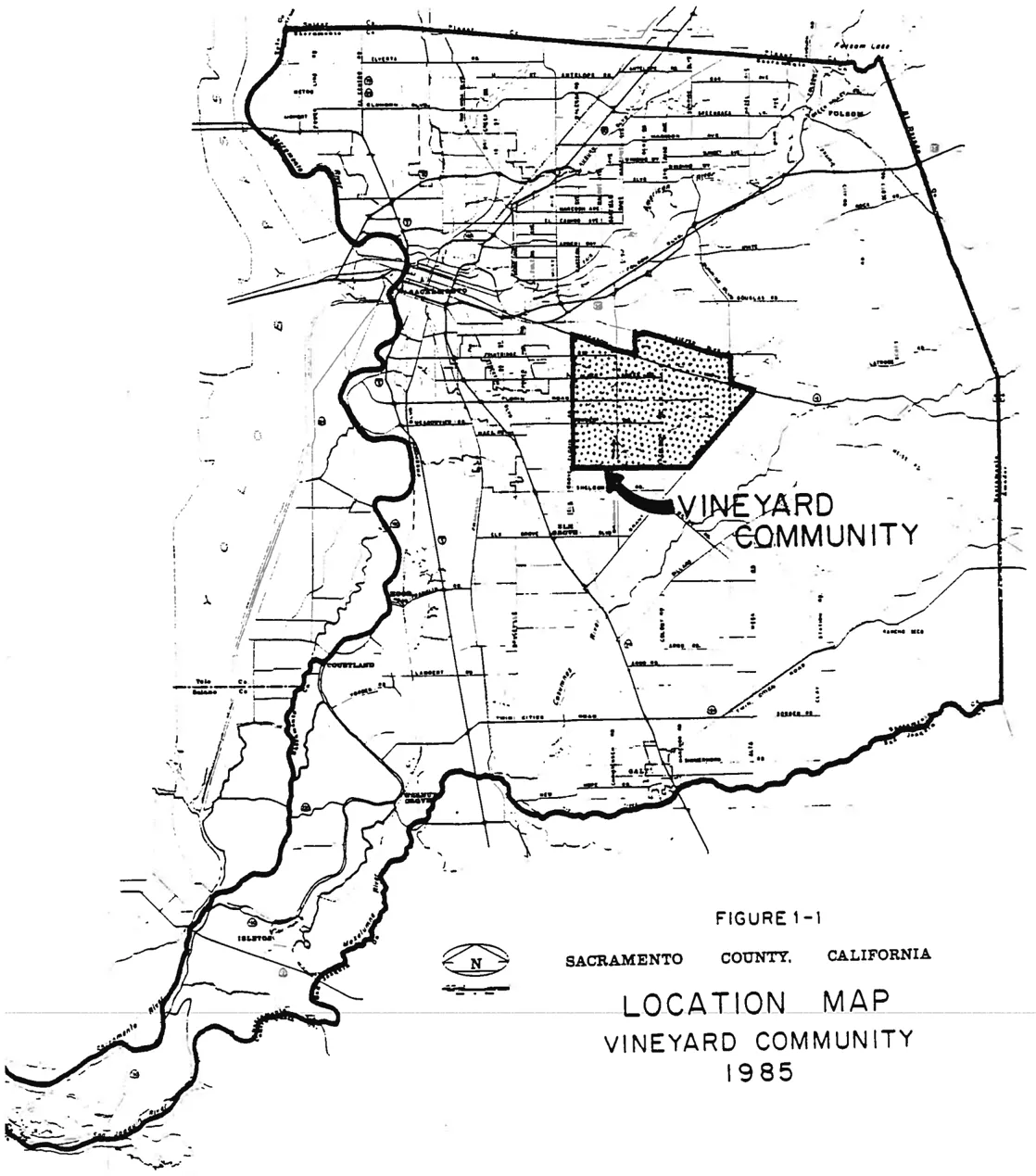
CHAPTER 1: INTRODUCTION
Section titled “CHAPTER 1: INTRODUCTION”General Location
Section titled “General Location”The Vineyard community area consists of approximately 37 square miles located in the central portion of Sacramento County. The area is generally bounded by the Jackson Highway and Kiefer Boulevard on the north, Sunrise Boulevard and Grant Line Road on the east, Calvine Road on the south and Elk Grove-Florin Road on the west. Vineyard is one of 17 community planning areas in unincorporated Sacramento County.
Purpose of the Plan
Section titled “Purpose of the Plan”This document has been prepared as a guide for the future growth and development of the Vineyard area. It includes community goals and objectives; policies and programs, and a recommended pattern of future land uses, which are an essential part of community development. The planning period for this document is considered to be ten years.
This community plan aligns to the Sacramento County General Plan as it relates to the Vineyard area. This community plans addresses a much smaller geographic area, and is therefore more specific and detailed. Although it is a complete document in its own right, it is consistent with and subordinate to the General Plan.
Plan Preparation
Section titled “Plan Preparation”This plan has been prepared by the Sacramento County Planning and Community Development Department with the advice of the Vineyard Area Community Advisory Council, which is appointed by the Board of Supervisors. A consensus of community attitudes and aspirations which, when translated into goals and objectives became the basis of the Community Plan. Policies, programs, and patterns of land use were developed which provide a public statement of the future growth and development of the community.
Assumptions
Section titled “Assumptions”Before analyzing a plan area, making projections for the future, and recommending courses of action regarding future development, certain assumptions about the future must be made. The following is a list of assumptions utilized in preparation of the Vineyard Community Plan.
- Much of the Vineyard Community will retain its rural character.
- Agriculture will remain an important land use in the eastern half of the community.
- Increased industrial development will occur in the northwestern portion of the community as public water and sewer services become available. This industrial development generally will not be employment intensive due to the areas proximity to Mather Air Force Base flight operations.
- Mather Air Force Base will continue to operate and have a major influence on the Vineyard Community.
- Mining of aggregates will occur in, the northwest section of the community. Surface mining will be an interim industrial use of properties in this area with eventual development for other industrial uses.
- Vineyard’s relatively small population will generally continue to increase by 2% per year for the majority of the community.
- Urbanization will be localized in the extreme southwest corner of the Vineyard Community.
- Increased industrialization and urban residential development in certain areas will bring about the need for extensive upgrading of public facilities and services for those areas.
- Growth throughout the County of Sacramento will have an impact on the Vineyard Community.
- Flood control measures will be necessary along streams in the Vineyard community, particularly in areas where significant development occurs.
Goals and Objectives
Section titled “Goals and Objectives”The Vineyard Area Community Planning Advisory Council developed goals and objectives to act as guidelines for the future development of the plan area. These generalized goals and objectives resulted in the formulation of specific policies and programs and the recommended land use plan. The Community goals and objectives are listed by specific categories.
Natural Environmental Resources Goals and Objectives:
Section titled “Natural Environmental Resources Goals and Objectives:”- To achieve and/or maintain air and water quality standards at or above state or federal mandated levels.
- To protect flood zones from encroachment or other adverse impacts.
- To preserve existing natural stream channels ; wetlands, vernal pools and wildlife habitats.
- To preserve and properly utilize the Vineyard Community’s mineral resources; while minimizing adverse impacts on adjacent land uses.
- To provide open space and recreational opportunities for all Vineyard residents.
- To achieve and/or maintain a quality environment within the Vineyard Community.
Agricultural Goals and Objectives:
Section titled “Agricultural Goals and Objectives:”- To preserve the agricultural orientation and rural-character of the Vineyard Community.
- To promote agriculturally oriented development and lifestyles within the Vineyard Community.
- To support state and local agricultural preservation and rehabilitation goals and policies.
- To encourage and support the broadening of agricultural viability criteria beyond the traditional SCS soil classifications to include but not be limited to, unit size, management practices, type of operation and water availability.
Agricultural-Residential Goals and Objectives:
Section titled “Agricultural-Residential Goals and Objectives:”- To recognize and support the necessity and desirability of Agricultural/Residential land allocation and uses as legitimate and appropriate in the Vineyard Community.
- To support land use proposals which will provide for reasonable housing growth consistent with the rural atmosphere and character of the Vineyard Community.
- To restrict small parcel agricultural-residential growth within the Mather Air Force Base Air Installation Compatibility Use Zones (AICUZ) for the protection of Vineyard residents and the mission of Mather Air Force Base alike.
Commercial/Industrial Goals and Objectives:
Section titled “Commercial/Industrial Goals and Objectives:”- To develop industrially designated areas in a manner that minimizes negative impacts upon the Vineyard Community.
- To encourage full development of existing industrially zoned or designated lands in lieu of expansion into areas not currently industrially zoned or designated.
- To encourage full utilization of industrially zoned lands by upgrading existing development.
- To-oppose rezoning to industrial (M-1 and M-2), areas within the General Plan Surface Mining Combining category where General and/or community plan policies indicate other zones or land use designations may be more appropriate (e.g. IR, UR, AG).
Public Facilities/Services, Goals and Objectives:
Section titled “Public Facilities/Services, Goals and Objectives:”- To provide adequate and appropriate infrastructure and public services to all residents and businesses of the Vineyard Community.
- To provide public protection services with acceptable response times for Vineyard residents.
Future Urbanization Goals and objectives:
Section titled “Future Urbanization Goals and objectives:”- To encourage infilling of property and the development of urban growth areas adjacent or contiguous to existing developed areas rather than permitting leapfrogging of urban residential development into primarily residential areas.
- To preclude expansion of urban residential growth into the Mather Air Force Base Air Installation Compatibility Use Zones (AICUZ) for the protection of Vineyard residents and the mission of Mather Air Force Base alike.
- To provide a wide range of housing types and living environments for present and future residents of the Vineyard Community.
- To ensure contiguous urban development which will maximize public service facility use and efficiency.
CHAPTER 2: THE COMMUNITY
Section titled “CHAPTER 2: THE COMMUNITY”NATURAL ENVIRONMENT
Section titled “NATURAL ENVIRONMENT”Location
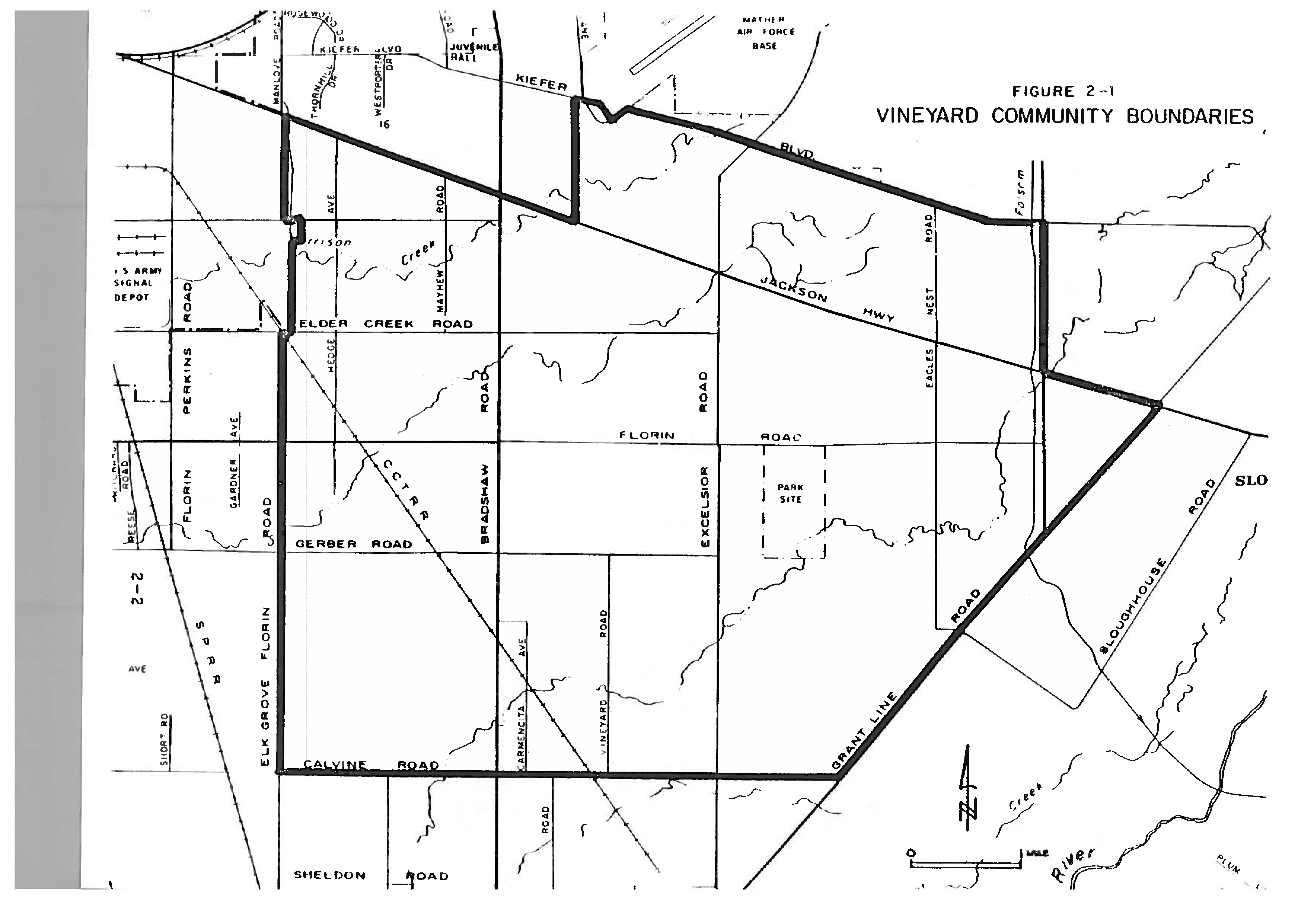
Section titled “Location”The Vineyard Community is located in central Sacramento County with an area of approximately 37 square miles. Surrounding community areas include Rancho Cordova the east, Elk Grove to the southwest, and South Sacramento to the west. Vineyard is bounded generally by Jackson Highway (State Route 16) on the north, Calvine Road on the south, Elk Grove-Florin Road on the west, and Grant Line Road and Sunrise Boulevard on the east. The community area also projects north of Jackson Highway to Kiefer Boulevard and along Kiefer Boulevard from about one quarter mile east of Bradshaw Road on the west and to Sunrise Boulevard on the east. Figure 2-1 illustrates the boundaries of the Vineyard Community.
Topography
Section titled “Topography”Vineyard is located on a broad, relatively smooth Sacramento Valley plain south of the American River. The plain profile in the area is generally very gently undulating and crossed in a generally westerly direction by Morrison Creek and Elder Creek, which is a major tributary of Morrison Creek. These creeks are the main hydrological features of the Vineyard area. Laguna Creek which crosses the southeast portion of the area is also a tributary of Morrison Creek, while Gerber Creek is a tributary of Elder Creek.
The natural microrelief of the Vineyard area is largely uneven, having hummocks, numerous drainage channels, and ill-defined hogwallows, but there are also localized level areas. The terrain is more undulating in east Vineyard which lies along the eastern portion of the valley plain. In west Vineyard the slopes are for the most part very gentle. The exception is the Elk Grove outlier which is a geologic entity where the slopes can be over 16%. The erodibility potential is considered moderate to moderately high on the outlier.
Geology and Soils
Section titled “Geology and Soils”Vineyard is located in the Great valley geomorphic province. The subdivision of the province pertinent to the Vineyard area is the Victor Alluvial Plain. The alluvial plain is underlain by older soils which characteristically contain extensive layers of hardpan. The elevations of the plain in this area range from approximately 45 feet in west Vineyard to almost 100 feet in east Vineyard. The important geologic formations underlying the plain are the Plio-Pleistocene alluvium sedimentary rocks of the Mehrten, Fair Oaks, and South Forks Gravel Formations, and the Victor Formation. The Victor Formation, an important source of aggregate resources, will be discussed further in the Mineral Resources section of this plan.
Hydrology
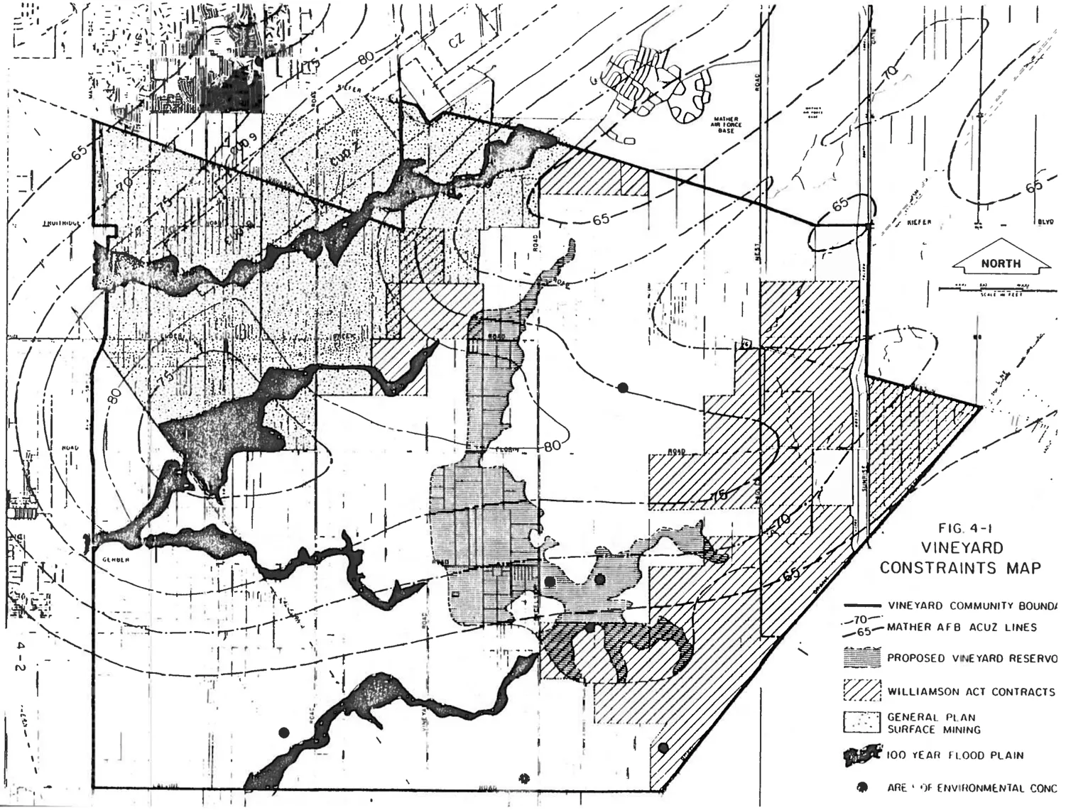
Section titled “Hydrology”Morrison and Elder Creeks have stream reaches where downcutting through layers of hardpan has resulted in almost vertical streambanks from 5 to 10 feet high. The existing 100-year floodplain of Morrison Creek is as much as l/2 mile wide, with much of this area is subject to shallow flooding in the form of sheet flow. The portions of the Elder Creek streamcourse that have not been channelized are also subject to flooding. Figure 4-l generally illustrates the flood plains of the Vineyard Community.
All of the Creeks in the area are part of the federally authorized Morrison Creek Stream Group project. The proposed Vineyard Reservoir site is located in east Vineyard. The reservoir, if constructed, would impound the upstream portions of the Laguna, Gerber, Morrison and Elder Creeks.
Morrison and Elder Creeks exhibit a meander type flow. This is evident by fresh bank erosion, and the presence of former channel remains and ox-bow ponds. The natural dry season flow of both Morrison and Elder Creeks is slow and sluggish with the stream slope gradients being generally very flat throughout most of the Vineyard area.
The drainageways along the eastern portion of Vineyard are almost without growth, while the western half of the streams are bordered by considerable riparian growth. The riparian growth becomes increasingly heavy in the stream reaches to the east of Elk Grove Florin-Road. Riparian vegetation and vegetation associated with vernal pools (which will be discussed in further detail in a forthcoming section) are considered the most important of the natural plant communities in Vineyard. The riparian plant community along Elder Creek is not considered significant, but the riparian plant community along Morrison Creek is unique and diverse. Streamside vegetation includes blackberry vines, valley oaks, cottonwoods, black walnut, poison oak, willows, and ornamentals which have been planted by nearby residents.
Vegetation
Section titled “Vegetation”Although the trees found on the plain of the Vineyard area are not numerous, they are large and isolated. The trees in the area include the native valley oak and cottonwood, and the introduced eucalyptus.
Vernal Pools
Section titled “Vernal Pools”Vernal pools are temporary ponds filled by winter and spring rainfall and at times natural drainage overflow from nearby intermittent streams. Some of the vernal pools in Sacramento County have developed unique characteristics. Many of the pools have developed distinct “rings” of flowers that bloom at slightly different times as the water level recedes throughout the spring. In general, vernal pools are the required habitat for nearly 30 plant species which are considered rare and endangered by the California Native Plant Society. Several of these species have also been officially designated as rare or endangered by State or Federal agencies; and several others are under consideration for such designation.
The Sacramento Orcutt Grass has been designated by the California Department of Fish and Game as an endangered plant species. The Sacramento Orcutt Grass is an annual vernal pool plant which is only found within Sacramento County and nowhere else in the world. The watershed of the vernal pool in which the Orcuttia population is found has been delineated by the Sacramento County Division of Water Resources of the Public Works Department. The Orcuttia grows on the beds of large vernal pools after the standing water which is characteristic of the pools, has infiltrated or evaporated.
Because the biological characteristics of vernal pools and the Orcutt Grass are not fully understood, it is not easy to develop conservation practices for these unique ecological entities. In order to adequately protect the resources of any particular vernal pool, it is necessary to identify the entire drainage shed for the pool. The drainage shed should not be impacted by impervious surfaces or any sources of water degradation. The drainage shed should also not be increased or decreased in size. If the drainage shed remains unchanged, the vernal pool can rely on the same water supply as was necessary to establish the flora within it.
For planning purposes, the existence of the vernal pools and potential associated unique plant species within the Vineyard area should be carefully considered. Specific vernal pool and Orcutt grass sites are described in the Land Use constraints section of this plan. Environmental review of project sites should be done on a case by case basis. If vernal pools are found on a given project site, the site should be inventoried for a more specific evaluation of the site. This inventory should be done during the spring preferably, because the species diversity is highest during that season. If rare or endangered species are found, people with expertise regarding vernal pools should be consulted before any project action is taken.
Animals
Section titled “Animals”Animal populations found in the Vineyard area include jack rabbits, coyotes, small rodents, snakes and raptors such as red tailed hawks, American kestrels, and white tailed kites. The eucalyptus trees in the area are used by the hawks and kites for nesting.
The riparian habitat of the creeks found in Vineyard provide shelter and food for racoons, opossums, grey squirrels and various types of amphibians. California quail, brushrabbit and gold finch utilize the bramble and willow thickets found along the streams as cover.
Bass, sunfish and bullheads can be found in Morrison and Elder Creeks and in the tributaries to the creeks. Striped bass are occasionally found in certain reaches of the streams. Populations of water associated wildlife species are also found in the streams. Crayfish, bullfrogs and aquatic invertebrates inhabit the stream channel of Laguna Creek. Fish populations in this area are either sparse αr non-existent.
Other animals found within the Vineyard area include black tailed hares, skunks, and birds such as songbirds and owls. Meadowlarks and other grassland species are also found in the area. Burrowing owls described by the state Department of Fish and Game as a “species of concern” have also been sighted in the Vineyard area. The editors of American Birds have included the burrowing owl on its blue list. Species which are put on the blue list have either recently undergone or are currently undergoing significant non-cyclical population declines.
While there are no endangered animal species which have been determined to be inhabitants of the Vineyard area, the Swainson’s Hawk, a state listed rare species, has been sighted in the area.
Mineral Resources
Section titled “Mineral Resources”The Victor Formation which underlies the plain where Vineyard is located is an important source of aggregate resources. The Victor Formation is composed of interbedded granitic sand, silt, and clay with lenses of metamorphic channel gravels, and includes buried meandering stream channel deposits composed of poorly sorted, but non-weathered, cobbles, gravels and sand. Surficial materials typically contain hardpan. Infiltration rates and permeability are low. The Victor Formation is important to Sacramento County aggregate resources, because known sand and gravel deposits of economic importance within the Sacramento area are restricted to the Victor Formation or dredge tailings derived from the Victor Formation.
The northwest section of the Vineyard community has been designated as a Surface Mining Combining Land Use category on the General Plan map. This section of Vineyard is bounded generally by Elk Grove-Florin Road on the west, Kiefer Boulevard on the north, Bradshaw Road and slightly beyond on the east, and Florin Road on the south. Since the area is designated by the Surface Mining Combining Land Use category, those General Plan policies pertaining to surface mining must be considered in land use planning.
The General Plan policies regarding surface mining combining categories are diverse. The policies provide for protection of the resource for economic purposes and also provide for protection of the environment by requiring mitigation for adverse environmental impacts. Policies also address buffering between surface mining uses, and residential and other uses incompatible with surface mining are designed to protect residences and other incompatible land uses from the impacts of surface mining. The community plan and General Plan policies pertaining to surface mining are included in the Land Use Constraints section of this plan.
Air Quality
Section titled “Air Quality”The photochemical oxidants found in California arises primarily from chemical reactions that occur in the atmosphere under the catalytic influence of solar radiation. In addition to photochemical oxidants, the Sacramento region is also subject to a deterioration of air quality from the presence of particulate matter. Although motor vehicles also contribute to the presence of particulate matter, in the Sacramento area the chief sources of particulates are usually smoke and dust from open fires, agriculture, industry; and construction activities.
Ozone, a photochemical oxidant, is a regional concern. Where the highest concentrations of this pollutant are found is dependent upon factors such as the wind pattern at a given time. For example, ozone pollution may originate in the City of Sacramento, but by the time it reaches the City of Folsom it may be at its highest level. . Carbon monoxide, which is produced by automobile engines, is the most commonly occurring and widely distributed air pollutant.
Air quality is monitored by collecting air samples and measuring the amounts of the various air pollutants contained in a given sample. Different air pollutants, including carbon monoxide and oxides, have been selected as indices of air quality because of the effects they have on plant and animal health, atmospheric aesthetics and material finishes.
Vineyard is located within the Sacramento Air Quality Maintenance Area (AQMA). In 1979 the Sacramento Regional Area Planning Commission (now the Sacramento Area Council of Governments) prepared a Final Air Quality Plan for the Air Quality Maintenance Area, as required by the Federal Clean Air Act (amended in 1977). The purpose of the required air quality plan was to develop a coordinated procedure for the Sacramento AQMA to achieve regional and national air quality goals.
The air monitoring station located closest to the Vineyard Area is at Branch Center Road in Rancho Cordova. This station measures 24 hour particulate concentrations every sixth day throughout a given year. There were no recorded exceedances of the National Ambient Air Quality Standards for particulates for the years 1982 and 1983 at this monitoring station.
The Del Paso Manor station located at 2701 Avalon Drive, north of El Camino Avenue and south of Marconi Avenue in the Arden-Arcade area measures the levels of carbon monoxide and ozone at one hour intervals for the nearby areas, including the Vineyard area. While this station recorded no exceedances of National Ambient Air Quality Standards for carbon monoxide for the years 1982 and 1983, ozone standards were exceeded 17 days in 1982 and 12 days in 1983.
The standards used in the harvesting of aggregates could contribute to the violation of standards set for airborne particulates and potentially affect residents in the vicinity of the mining operation. The impact on the residents would be a result of the nuisance dust conditions resulting from the mining activity. It is not likely that NAAQ health standards for particulates would be exceeded as a result of aggregate harvesting alone. High volume sampling conducted by the County Air Pollution Control District indicates that many dust sources combine; which then results in a violation of the NAAQ standards. It has been found that dust complaints occur primarily when overburden is being removed or when haul roads are not watered. The greatest cause of fugitive dust is the act of removing overburden because the first several feet of the soil is dry. watering is not an effective method for reducing dust emissions during the removal of overburden because the water only dampens the top several inches of soil. The naturally damp soils are not reached until several feet of overburden have been removed.
Water Quality
Section titled “Water Quality”Sacramento County generally has ground and surface water of good quality, the exceptions being low level water quality problems in certain areas of the County and contamination problems in some areas. For example, some wells in the Rancho Cordova area are unusable due to groundwater contamination resulting from industrial activities. Groundwater quality is also adversely affected by the presence of iron and manganese (naturally occurring substances) in certain areas of the County, including the Vineyard area. The iron and manganese does not usually create a health hazard, but it does affect water taste and may cause laundry and/or fixture staining problems.
Groundwater quality in Northeast Vineyard is presently considered good to excellent. In the southwest portion of Vineyard there is a possible groundwater problem resulting from the presence of dissolved gases and high mineral concentrations. There is also concern regarding future ground water contamination potential, particularly in areas near Mather Air Force Base and the old Gerber dump. However, to date no contamination within the Vineyard Community has been documented.
Water Provision
Section titled “Water Provision”The key policy of the 1978 Sacramento County Water Plan is that groundwater overdraft must be halted by the year 2000 or earlier. In addition, General Plan policy 3.6.10 requires the development of conjunctive use plans if groundwater supplies are to be used to provide water to growth areas which are subject to overdraft. Overdraft results when water table levels decline (pumping exceeds annual recharge) and can cause an increase in the cost of water service, a decrease in water quality; and subsidence (See Figure 2-2).
The objective of a conjunctive use plan is to develop a strategy to avoid water groundwater overdraft and achieve a balance in groundwater levels by using surface water where and when it is available. Using surface water when it is available permits replenishment of groundwater aquifers through natural percolation.
The lack of an interjurisdictional conjunctive use plan is one reason available surface water in the Sacramento region has not been utilized. Other factors contributing to the underutilization of surface water include cost constraints, past availability of groundwater supplies and contractual restraints. There is currently a County-City-Arcade Water District funded study being conducted to determine how surface water could most effectively be provided to growth areas within the Sacramento region.
Studies regarding water provision to the Vineyard area have divided Vineyard into East Vineyard and West Vineyard for analysis purposes. The East Vineyard study area is bounded by Gerber Road on the east and Bradshaw Road on the west. The West Vineyard study area is bounded on the north by a property line extending west from the terminus of Rogers Road, Calvine Road on the south, Bradshaw Road on the east and Elk Grove-Florin Road on the west.
The residents of East Vineyard are currently using groundwater for their water supply. Although the use of groundwater is expected to continue in this area, the existing groundwater overdraft problem would get worse as a result of the continued usage. Currently, there are no water districts serving East Vineyard. Although East Vineyard is in a suitable location to receive surface water supplies from the Folsom South Canal, this is not likely at this time due to pending litigation regarding water diversions from the Folsom South Canal project. A feasible alternative source is the City’s American River Treatment Plant. Acquisition of the water could be accomplished with a direct contract between the County water agency and the United States Bureau of Reclamation (USBR). Sacramento County’s Water Resources Division has recommended that East Vineyard be included in the ultimate service area for the City surface water supply from the American River Treatment Plant.
As is the case with East Vineyard, the groundwater source which is providing water to West Vineyard at the present time is subject to declining groundwater levels. Although there is currently no water purveyor operating in West Vineyard, the portion of the area which lies north of a line extending from Lemas Road is within the City of Sacramento’s American River water use area. Providing surface water through the City’s system to this portion of West Vineyard would not be a problem. South of Lemas Road, the city’s water system could also be used, but the water would have to come from a separate contract with USBR unless an expansion of the existing water use boundary was obtained. The current Citizen’s Utility service area extends to Elk Grove-Florin Road. The County Water Resources Division believes Citizen’s Utility Company would be the best purveyor for West Vineyard, due to its close proximity.
Figure 2-2: Spring 1968 to Spring 1980 Equal Change Ground Water Levels
Section titled “Figure 2-2: Spring 1968 to Spring 1980 Equal Change Ground Water Levels”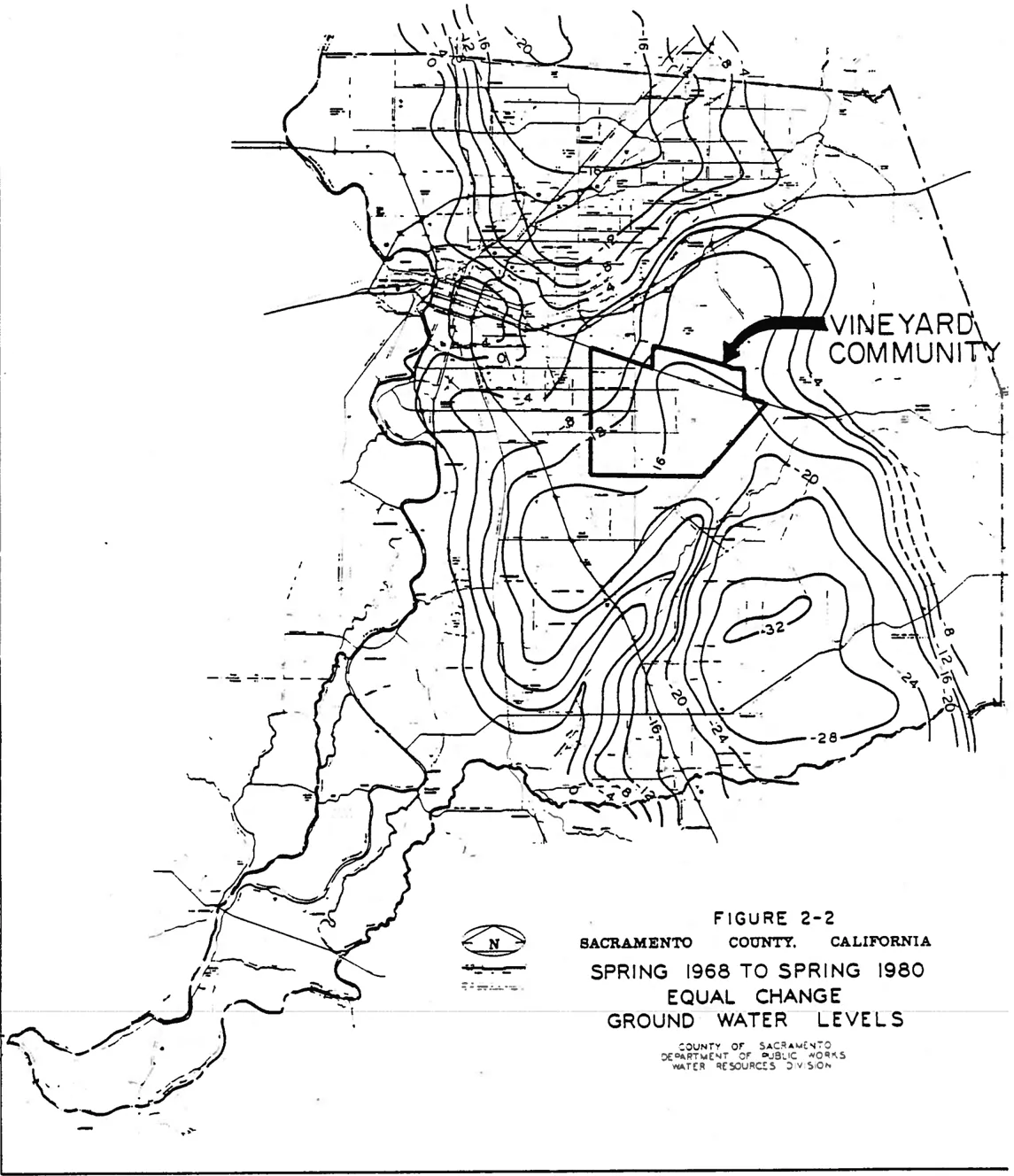
CULTURAL ENVIRONMENT
Section titled “CULTURAL ENVIRONMENT”Vineyard Area History
Section titled “Vineyard Area History”Historical data, specific to the Vineyard Community; is difficult to delineate. The earliest inhabitants of the region were, however, native American Indians. Sites of occupation have been identified near the American River and on the higher areas of the Cosumnes River and Deer Creek. The Vineyard area is, however, low lying. The predominant water courses, Morrison Creek and Laguna Creek, are typically dry during much of the year. Although the area was undoubtedly utilized for hunting and other food gathering purposes, little sign of permanent occupation can be expected. During the Gold Rush Days (approximately 1848-1852), Jackson Road was used by miners travelling from Sacramento to the gold country. The Vineyard area was considered to be within the Brighton Township as delineated by the Sacramento County Board of Supervisors in 1851 and 1856. A portion of the Vineyard area was located within the Rancho Rio de los Americanos Grant. Early development occurred primarily north of the Vineyard area until Jackson Road became established. After Jackson Road was constructed, farming, including vineyards, became profitable in the area. One of Vineyard’s early residents was George McMullen who moved to the Vineyard area in 1875 when he purchased a 240 acre farm known as “Lizzie’s Vineyard”. All 240 acres were arable. 85 acres were set in vines and produced loo tons of grapes annually. Strawberries were also grown on McMullen’s property.
Mather Air Force Base and the Community
Section titled “Mather Air Force Base and the Community”Mather Air Force Base’s southern boundary is contiguous with the northern boundary of the Vineyard Community area. Mather AFB is a small community within itself, with a working population of about 6,900 military and civilian personnel. The total base population including dependents is over 13,900 people. The base consists of approximately 5,900 acres which includes two runways, taxiways, ramps, industrial areas, housing, recreational facilities, and undeveloped areas. The undeveloped areas of the base are the minimum required to form a barrier between the base and the surrounding community for safety and security, and to permit some room for future development of base facilities.
Mather has a significant influence on the Vineyard Community. While it does have a positive impact on the area economics, flight operations at Mather have tended to dictate land use patterns in the community; since aircraft flight patterns and resultant noise zones cover much of the Vineyard Community.
In October 1917, the Sacramento Chamber of Commerce launched a campaign for Sacramento to be chosen as a site for the training of Army aviators. Land was obtained in February 1918 by the Chamber of Commerce and presented to the United States Government by the community of Sacramento. Construction of the base began the following month.
The first aviators arrived at Mather Field on 8 June 1918, and the first flight from the base was made four days later. Although inactivated for short periods of time, the mission of Mather Air Force Base has continually expanded over the past 40 years. Mather’s development has therefore been an important influence on the history of the Vineyard Community itself. It must be assumed also, that Mather will continue to have a major influence on the Vineyard Community and its development. Therefore, the impacts of Mather Air Force Base upon the Vineyard Community were given serious consideration in the development of this plan.
Vineyard Community Demographic Profile
Section titled “Vineyard Community Demographic Profile”The following profile describes the population characteristics of the Vineyard community. An attempt has been made to present the available statistics about the community’s population in an understandable form. This discussion is meant to provide the reader with an overview of some distinguishing characteristics of the Vineyard community. Population analysis is also an important aspect of the community planning process. Past trends and future population projections are the basis for planning for future needs such as schools; parks, commercial areas, and other services.
Selected population characteristics for Vineyard are shown in Tables 2-l and 2-2. For comparison purposes, figures for Elk Grove and Sacramento County, as a whole, are also given. The total population of the Vineyard community is rather small compared to other communities in Sacramento County. Based upon the Sacramento Area Council of Governments’ 1984 Population Module, Vineyard’s current population is 3,204. This is only 86 persons per square mile, indicative of the existing rural character of the Vineyard area. Comparatively Elk Grove has 323 persons per square mile and the County as a whole has 797 persons per square mile. The median age of the population is 28.4 years of age, which is only slightly younger than the County median age.
Ethnically, in 1980 Vineyard was predominantly white as shown on Table 2-4. Compared to Sacramento County which was 85.5% White, Vineyard was 92.4% White. Vineyard is home to a significant number of individuals of Japanese and Filipino descent. It has a slightly lower number of individuals of Spanish origin than the County average, and a much lower number of Blacks.
As a whole, the Vineyard community enjoys a higher median household income though its educational attainment level is significantly lower than the County’s. Vineyard has a much lower percentage of its total dwelling units constructed since 1970 than does the neighboring community of Elk Grove, although this is not unexpected since Elk Grove has experienced significant urban growth in recent years while Vineyard has experienced none. Approximately half of Vineyard’s housing stock was constructed between 1940 and 1970, which is only slightly higher than the County average for this thirty year period. Almost 12% of the existing dwelling units in Vineyard were built prior to 1940.
TABLE 2-1: SELECTED POPULATION CHARACTERISTICS FROM THE 1980 CENSUS
Section titled “TABLE 2-1: SELECTED POPULATION CHARACTERISTICS FROM THE 1980 CENSUS”| Population Characteristic | Vineyard | Elk Grove[2] (comparative) | Sacramento County |
|---|---|---|---|
| Total Population (1980) | 2,923 | 13,411 | 783,381 |
| Total Population (1984)[1] | 3,204 | --- | 858,500 |
| Persons per square mile (1980) | 79 | 323 | 797 |
| Median age (1980) | 28.4 | 28.3 | 29.8 |
| White, % of total population by race | 92.4% | 95.2% | 85.5% |
| Black, % of total population by race | 1.1% | .9% | 8.0% |
| American Indicans, Eskimos, Aleuts, % of total population by race | .6% | 1.4% | 1.2% |
| Asians and Pacific Islanders, % of total population by race | 5.9% | 2.5% | 5.3% |
| % of total population indicated as of Spanish origin | 8.2% | 7.6% | 9.5% |
| % of persons 25 years or older who have completed 8 years or less of school | 16.3% | 9.4% | 10.5% |
| % of persons 25 years or older who have completed 4 years of high school or more | 67.5% | 80.7% | 77.9% |
| % of persons 25 years or older who have completed 4 years or more of college | 10.7% | 17.7% | 19.3% |
| Total dwelling units (1980) | 1,066 | 4,653 | 323,702 |
| % of du’s built since (1970) | 38% | 68.3% | 35.2% |
| % if du’s built prior to (1940) | 11.8% | 4.4% | 9.2% |
| Median Household Income (1980) | $22,677 | $23,876 | $17,390 |
[1] SACOG 1984 Population Module
[2] Bureau of Census Neighborhood Statistics Program Figures for 1980
TABLE 2-2: 1980 VINEYARD POPULATION BY AGE AND SEX
Section titled “TABLE 2-2: 1980 VINEYARD POPULATION BY AGE AND SEX”| Age | Male | Female | Total | Total % | Sac. Co % |
|---|---|---|---|---|---|
| 0-4 | 94(3.2%) | 73(2.5%) | 167 | 5.7% | 7.3% |
| 5-14 | 244(8.3%) | 227(7.8%) | 471 | 16.1% | 14.6% |
| 15-59 | 1008(34.5%) | 936(32.0%) | 1944 | 66.5% | 64.6% |
| 60-64 | 70(2.4%) | 70(2.4%) | 140 | 4.8% | 4.2% |
| 65+ | 115(3.9%) | 86(3.7%) | 201 | 6.9% | 9.3% |
| Total | 1531(52.4%) | 1392(47.6%) | 2923 |
Vineyard’s total population, although small, has steadily increased over the past 15 years. The largest increase occurred between 1970 and 1975, involving a 16% increase in total residents of the Vineyard community. Population growth has slowed since 1975, increasing approximately 9% for subsequent five year periods. These growth rates, while large compared to Sacramento County as a whole, are much lower than many newly urbanizing areas of the County. When urbanization does occur, dramatic changes in the overall Vineyard population will result. Vineyard’s population could approximately quadruple with the urbanization of the Urban Reserve area. This growth would, however, be very localized, and the character of the rest of Vineyard would be expected to change far more slowly.
CHAPTER 3: EXISTING LAND USE
Section titled “CHAPTER 3: EXISTING LAND USE”Land uses which are existing when a community plan is being developed form the foundation upon which the plan is built. One of the purposes of a community plan is to give direction to future growth and to ensure compatibility with existing land use conditions. Existing land uses in Vineyard are primarily the result of land use constraints, discussed in Chapter Four, as well as past and present General Plan land use categories.
Current General Plan Land Use Categories and Zoning Classifications
Section titled “Current General Plan Land Use Categories and Zoning Classifications”The General Plan of Sacramento County currently indicates eight land use categories within the Vineyard Community. General Agriculture, Agricultural-Urban Reserve, Agricultural-Residential, Industrial (Extensive), Industrial (Intensive), Surface Mining, Recreational and Public/Quasi Public are the land use categories which have been applied to property in Vineyard. The first six of these categories are of considerable importance since they cover large portions of the Community. These six categories are defined in the General Plan as follows:
General Agriculture
Section titled “General Agriculture”This land use category represents agricultural land less suited for intensive agricultural pursuits. It includes dry grain and irrigated and dry pasture for the most part. Most soil classes range between IV and VI on the Soil Conservation Service scale. Some or all of the following constraints are exhibited in this category: shallow soils, uncertain water supply, moderate slopes, fair to poor crop yield, farm unit fragmentation, and elusive agricultural-residential boundaries. As a result of these constraints, less ambitious preservation policy and techniques are desirable.
Agriculture-Urban Reserve
Section titled “Agriculture-Urban Reserve”The function of this land use category is to provide a reserve area for future urban expansion when the pressure of population growth within the planned urban areas can substantiate the need for making more land contiguous to the urban area available for development. The location and extent of this category is determined by its purpose. It is located contiguous to planned urban areas and is suitable for urban development. Most of the land is suitable for agricultural uses, although, to the extent possible, the very best agricultural land has been excluded. Since most of this land will serve as open space throughout the planning period of the General Plan, most of the same policies which apply to Agricultural Cropland and General Agriculture apply to Agriculture-Urban Reserve. So long as land remains in this classification, no additional urban type public services (.e.g., water and sewer systems) above the level existing when the land is designated Urban Reserve will be provided, nor will urban type land uses or division of land which would be incompatible with orderly and well-planned future urban development be permitted.
Agricultural Residential
Section titled “Agricultural Residential”This land use category identifies areas which are set aside and protected for large lot rural residential uses where the keeping of animals and the raising of crops for education, recreation, or income supplement is permitted. The intent of this category is to assure the long-term viability of the rural residential uses. It is not intended to serve as a reserve area for more intensive uses at some future time. Soil type, water supply, parcel size and historical uses and trends are among the criteria used in determining the location and extent of this land use category. Agricultural Residential districts are of sufficient size and located so that potential conflicts with incompatible land uses are minimized. The minimum lot size in Agricultural Residential districts may range from one to ten acres. The Board of Supervisors may establish specific minimum lot sizes within this range for any of the Agricultural Residential areas of the County by various means, including resolutions, ordinances; and community plans. If no specific minimum has been so established for a given geographic area, the minimum lot size shall be five acres. These very low density areas require and support fewer urban services than more densely populated areas; schools and shopping centers are fewer in number and more widely spaced; and public water supply and sanitary sewer facilities are often not necessary.
Industrial (Extensive)
Section titled “Industrial (Extensive)”In one sense, this is an industrial reserve area; planned for industrial use sometime after 2000. In another sense, however, it is available for immediate industrial use. If an industry requires a large area and wishes to provide its own water and sewer systems and does not require a high level of other urban services, this land may appropriate for use any time during the next 20 years. The significant difference between this category and the intensive industrial category is the timing of the urban type public services to the area. Industrial (extensive) areas will not be provided with major public services during the planning period.
Industrial (Intensive)
Section titled “Industrial (Intensive)”The purpose of this land use designation is to provide for research, manufacturing, processing and warehousing activities of an intensive nature. Sufficient space has been provided to accommodate a wide variety of industries with differing locational requirements. Among the criteria used to determine the location and extent of this category are physical character, availability of transportation facilities and utilities, and minimization of potential land use conflicts. Since areas where the provision of all needed services is either existing or anticipated during the planning period. These areas will be protected from conflicting uses to insure their availability for new industries. In some communities, portions of this land use category may be set aside for industrial park uses, where development and performance are carefully regulated.
Surface Mining
Section titled “Surface Mining”This category identifies areas where valuable mineral resources are known to exist and where specific policies which encourage the conservation and wise use of mineral resources while ensuring the maximum feasible protection of the environment are specifically directed. This is a combining land use category which is combined with such basic land use categories as Industrial Intensive, Industrial Extensive, Agriculture-Urban Reserve, Agricultural Cropland, and General Agriculture.
Figure 3-1 indicates where these land use categories are located within the Vineyard Community. Current zoning classifications, a primary General Plan implementation tool, are generally consistent with these land use categories. Inconsistencies do however exist at isolated locations, because of historical uses of specific properties.
Existing land use generally follows the aforementioned General Plan land use categories. Vineyard’s existing land use is summarized in Table 3-1.
FIGURE 3-1: VINEYARD COMMUNITY AREA EXISTING GENERAL PLAN LAND USE CATEGORIES
Section titled “FIGURE 3-1: VINEYARD COMMUNITY AREA EXISTING GENERAL PLAN LAND USE CATEGORIES”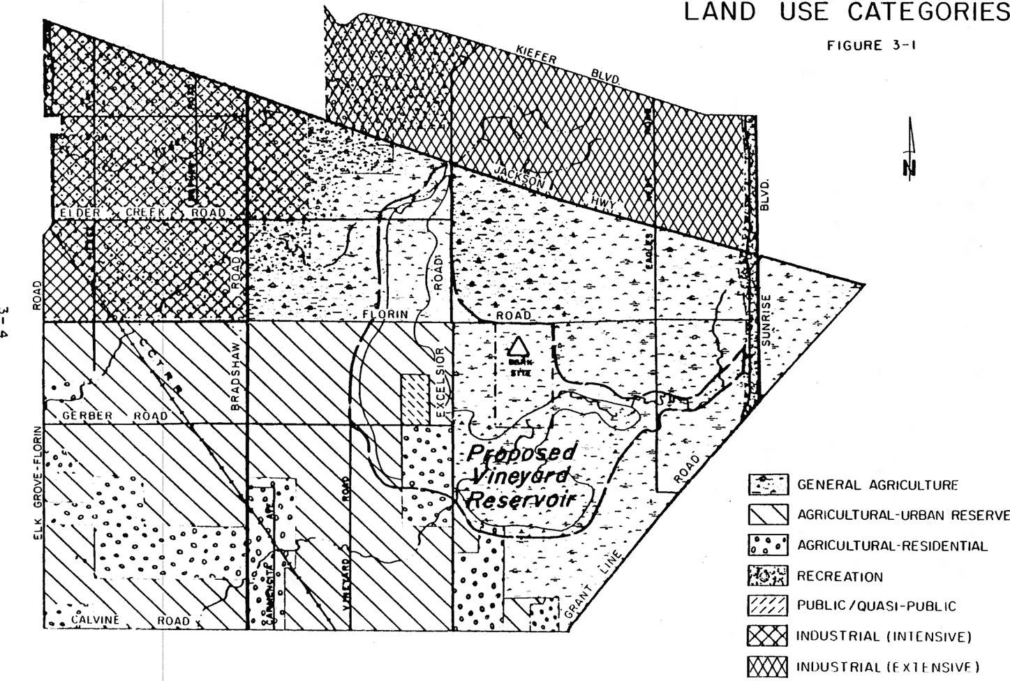
TABLE 3-1: Vineyard Existing Land Use
Section titled “TABLE 3-1: Vineyard Existing Land Use”| Irrigated Pasture | 3,319.2 Acres |
|---|---|
| Irrigated Crops | 364.8 Acres |
| Orchards | 67.5 Acres |
| vineyards | 18.6 Acres |
| Dry Farming | 18,454.4 Acres |
| Other Agricultural | 415.3 Acres |
| Private Recreation | 26.2 Acres |
| Single Family | 164.8 Acres |
| Mobile Home | 6.7 Acres |
| Commercial | 9.7 Acres |
| Public/Quasi-Public | 32.4 Acres |
| Industrial. | 557.6 Acres |
| Surface Mining | 349.9 Acres |
| Total | 23,787.1 Acres |
Agriculture
Section titled “Agriculture”Agriculture remains the predominant land use in Vineyard. Dry farming is the primary agricultural pursuit, with the majority of this area being utilized for pasture. Dry farming occupies approximately 77% of Vineyard’s land area. Irrigated pasture is the second largest land use in Vineyard, occupying about 14% of the area. While a substantial portion of this irrigated pasture occurs in association with agricultural-residential uses, the remainder is related to beef and dairy production.
As the community’s name indicates this was once an area known for its viticulture. Today however, based upon a field survey: only one producing Vineyard remains within the community. Truck farming, including orchards, has also dwindled significantly; and today comprise only a very small percentage of agricultural land use in Vineyard. Only about 17% of the Vineyard area is currently irrigated. This is due primarily to topographic characteristics, soil conditions and availability of irrigation water. One agricultural land use which has expanded significantly in recent years is horticultural plant production. Large nursery growing areas have been established along Bradshaw and Excelsior Roads.
Agricultural-Residential Uses
Section titled “Agricultural-Residential Uses”Several agricultural-residential communities have been established in Vineyard over the years. These areas are primarily in the western and southern sections of the community. While these areas do not occupy large land areas or contribute substantial populations, they can undoubtedly be considered the most recognizable and characteristic land use within the community. An alternative life-style is provided residents of these areas. Incidental agriculture is usually associated with the residential use of these properties. Agricultural-residential uses generally occupy parcels in the one to ten acre range, however a significant number of twenty acre parcels are now occupied by this use within the Vineyard Community.
There exist throughout the community small concentrations of large lot residential uses. These parcels are generally less than one acre in size and are not utilized for incidental agriculture. These parcels were created under historical zoning requirements and prior to significant concerns related to environmental health issues. Currently, based upon soil conditions in the Vineyard area, five acres is generally considered the minimum size for parcels with private wells and septic systems.
Industrial Uses
Section titled “Industrial Uses”While large areas of the Vineyard community are indicated on the General Plan for industrial use, the majority of that area is not yet so developed. The primary reason for this minimal industrial development is the lack of public services, namely public sewer service and a public water supply.
The large industrial extensive area north of Jackson Road contains in reality only one industrial user, Sacramento Rendering Company. The industrial intensive area south of Jackson Road, just east of Elk Grove-Florin Road, contains a variety of industrial uses. These uses are generally not intensive; as the General Plan category would indicate, because of the lack of public services. Contractors storage and small fabrication industries appear to be the predominant industrial uses within this area, which remains intermixed with agricultural and agricultural-residential uses. It is likely that public services will become available within the near future, which will accelerate growth and intensification of industrial uses.
Surface Mining
Section titled “Surface Mining”Surface mining, which is considered a short-term industrial activity is a major land use in Vineyard. The majority of the northwestern quadrant of the Vineyard Community; approximately 5000 acres; is indicated with the surface mining combining land use category on the County General Plan. Of this area about 517 acres have been mined, are being mined, or are approved for mining. In addition, approximately 1,350 more acres are currently under the ownership of aggregate companies.
The County General Plan contains the following policies pertaining to surface mining and aggregate resources:
- Continue use of the surface mining combining land use zone in areas where it is in the County’s interest to protect known mineral resources which require surface mining, and continue regulations which protect the mineral resource from the encroachment of land uses which would preclude the extraction of materials.
- Continue the use of regulations which buffer the surface mining land use categories from residential and other uses incompatible with surface mining.
- Continue to insure that, after mitigative measures are taken, a surface mining operation will not create any significant nuisances, hazards, or adverse environmental impacts.
- In order to protect scenic and economic values, continue to require that all surface mining operations provide for adequate reclamation of mined lands before issuing surface mining permits.
- Encourage aggregate mining and resource conservation to provide low consumer costs by promoting the utilization of sand and gravel resources convenient to the urban area; and by allowing competition among the different aggregate producers.
Approximately 5 million tons of sand and gravel are extracted in Sacramento County each year. Vineyard produces about 80 percent of the total. Most of this sand and gravel is used for aggregate in the construction of highways, public facilities, structures, and as home building material. In terms of value and tonnage, natural sand and gravel is by far the most important mineral aggregate in California and is the only aggregate used in Sacramento County for general construction purposes. Protection of existing and future potential uses in the: area must be included in all decisions regarding this resource.
Miscellaneous Land Uses
Section titled “Miscellaneous Land Uses”Commercial uses are currently centered along Jackson Highway and Bradshaw Road. These uses consist primarily of small shops, stores, gasoline stations and bars which serve the travelling public, and to a limited degree, local residents.
Recreational uses are also in evidence in the Vineyard Community. Sacramento Raceway, a major drag and motorcycle racing facility, is located on Excelsior Road, north of Jackson Highway. A number of events each year, attract significant crowds of spectators. Rancho Arroyo, located south of Jackson Highway; east of Bradshaw Road, appears to be developing into a major private recreational-sports facility.
Transportation Facilities
Section titled “Transportation Facilities”The Vineyard Community is presently served primarily by a system of local streets. Jackson Highway, State Route 16, parallels and passes through the northern part of the community. While Jackson Highway is part of the State highway system, it remains a two lane roadway. Much of the street and highway system in Vineyard is proposed for upgrading in the future, however, with the exception of Elk Grove-Florin Road these expanded facilities are not imminent.
There is currently no transit service available in the Vineyard area and none is presently planned. Central California Traction Company’s railroad right-of-way extends diagonally through the Community. This right-of-way currently receives minimal utilization. The County Major Street and Highway Plan indicates this railroad right-of-way as a future transportation corridor.
Other Public Facilities and Services
Section titled “Other Public Facilities and Services”The Vineyard area presently lacks many of the typical urban public services. Public water is presently unavailable. This inavailability has minimized industrial development and has resulted in requests for annexation to the adjacent City of Sacramento.
A major sewer interceptor extends along Elk Grove-Florin Road for a significant portion of its length adjacent to the Vineyard Community. To date, however, there have been no connections to this interceptor from the Vineyard area.
Vineyard lies within the Elk Grove School District. Sierra Enterprise School, located at Hedge Avenue and Fruitridge Road, is the only school located within the Vineyard Community at the present time. Sierra Enterprise serves 290 K thru 6 students, as well as, 15 junior high school students.
The Florin Fire Protection District provides fire protection services to the majority of the Vineyard area. A small fire station is currently located on Elder Creek Road, just east of Bradshaw Road. Another station will become operational in the very near future on Excelsior Road, south of Gerber Road.
Due primarily to the existing rural character of the Vineyard area, there are no developed park sites at the present time. The Southgate Recreation and Park District was recently expanded to include all of the Vineyard Community south of Jackson Highway, and would be considered the park services provider for the area. Sacramento County currently holds ownership of 320 acres one half mile east of Excelsior Road between Florin Road and an extension of Gerber Road. This acreage is indicated as a future park site on the Sacramento County General Plan.
Police protection in the Vineyard plan area is provided by the Sacramento County Sheriff’s Department and California Highway Patrol. The Highway Patrol handles incidents related to traffic, while the Sheriff’s Department handles all other investigations in the area. Coverage by these two agencies is minimal at the present time due to Vineyard’s rural character.
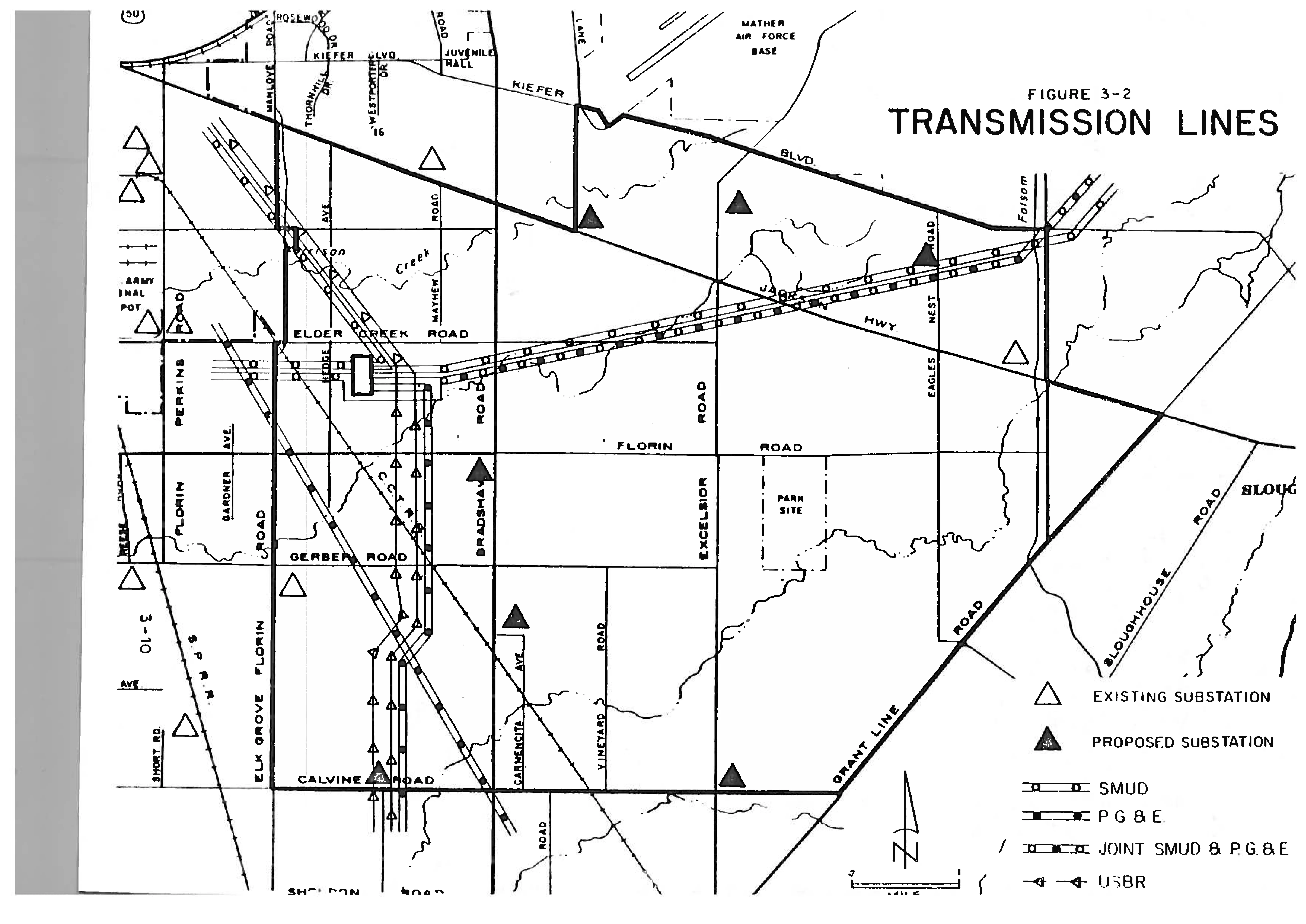
Electricity is provided in the community by the Sacramento Municipal Utility District, which has a major switchyard located at Hedge Avenue and Tokay Lane. SMUD, as well as Pacific Gas and Electric and the U.S. Bureau of Reclamation have major transmission facilities which traverse the Vineyard Community. These transmission facilities do have a considerable impact on the community, with transmission line easements in several areas exceeding 400 feet in width. Figure 3-2 indicates these transmission facilities, as well as existing and proposed substation sites.
CHAPTER 4: LAND USE CONSTRAINTS
Section titled “CHAPTER 4: LAND USE CONSTRAINTS”In the preliminary stages of the development of the Vineyard Community Plan land use constraints were identified and mapped (See Figure 4-1). Although the constraints identified are primarily constraints to urban type development, in a few instances other uses could be affected. For example, according to the Mather Air Force Base Land Use Compatibility Guidelines, residential uses are discouraged in areas with a noise impact of 65-70 Ldn but industrial/manufacturing uses are considered compatible.
Specific constraints were identified as land use restrictions after a review of General Plan policies, community plan goals and objectives and physical constraints found in the area. This section of the plan will present a summary of each identified constraint and any applicable General Plan policies. The relevant community plan policies are referenced in the list in Chapter Seven of this Plan.
Air Installation Compatible Use Zone (AICUZ)
Section titled “Air Installation Compatible Use Zone (AICUZ)”The concept of an Air Installation Compatible Use Zone (AICUZ) was developed to:
- “Protect local citizens from the noise and accident hazards associated with flying activities.” and
- “to prevent degradation of mission capability from encroachment.”
An AICUZ is developed subsequent to a study of the different types of aircraft which use a given base, where and how high the aircraft fly, the number of times the aircraft fly over an area and the times during the day or night that the flights occur. Accident Potential Zones (APZ’s) and Noise Zones (NZ’s) for Air Force bases are developed from the data gathered during the study. Compatible Use Districts are then delineated by overlaying the APZ’s and the NZ’s on a map of the area being considered. The Air Force base provides affected communities with guidelines for compatible land uses within identified Compatible Use Districts. The purpose of the guidelines is to limit the high densities of people in the high accident potential and the high noise level areas.
Mather Air Force Base is located immediately north of the Vineyard area. Because of the noise impact on a considerable portion of the Vineyard area, the Mather Air Force Base AICUZ boundaries were considered a constraint in the development of the community plan. The noise contour lines were mapped and the associated land use compatibility guidelines included in the Mather Air Force Base AICUZ Report reviewed during the development of the proposed land use plan. It is important to consider the AICUZ boundaries a constraint because the current land use compatibility guidelines recommend prohibition of residential uses in some high noise impact areas and strongly discourage residential uses in others. In zones where residential uses are strongly discouraged, noise level reduction measures may be required for residential buildings that are permitted by the local jurisdiction.
The community plan policies which address the AICUZ constraints are AR-2, CI-1 and CI-5.
Applicable General Plan policies are provided below.
-
2.62. Regulate land use and development in the vicinity of potentially hazardous industrial activity; airport crash hazard zones, waste handling facilities (liquids or solids) which might be regarded as incompatible with adjacent residential uses, and in any other hazardous activities.
-
3.5.14 Protect public use and military airports from the encroachment of incompatible uses which would endanger their efficient operation.
-
3.5.17 Noise levels and accident potential. associated with airfield operations make it necessary to limit the density of development and the intensity of use in the vicinity of airfields. It is the policy of Sacramento County that:
- The Airport Land Use Commission (ALUC) Policy Plan guidelines for airport land use compatibility, as well as the Air Installation Compatible Use Zone (AICUZ) Report guidelines for the appropriate military airfield, will be considered during the hearing process on any planning matter within an airfield environs (References to noise levels in the following statements relate to the noise contour maps included in the AICUZ Reports and the ALUC compatibility plans for each airport as they are developed. Interested parties may substantiate or modify the noise contour data by retaining a qualified acoustical consultant to reassess a noise site exposure through adequate noise monitoring).
- Any reduction of lot sizes for residential uses where the noise level exceeds 70 Ldn shall be deemed as inconsistent with this Plan, unless the Board of Supervisors first determines, on recommendation of the appropriate Planning Commission, that the proposed subdivision or parcel map is an "infill development" which meets the following criteria:
- More than 50% of the periphery of the proposed subdivision is abutted by existing residential development of equal or greater density.
- Non-residential development of the property is infeasible due to significant potential conflicts with residential uses in the vicinity or lack of need for such non-residential uses in the area.
- The density of the proposed development does not exceed that permitted under the RD-5 land use zone.
- In all other respects, the proposed development conforms to the General Plan and the adopted community plan for the area.
- Where the noise level is 65 to 70 Ldn, denial of residential developments may not be warranted solely because of noise impacts, but the potential noise impact, in conjunction with other concerns (i.e., circulation, design, density, etc.), may compound the potential problems for future residents to such an extent that denial is warranted.
2.8.8 The following table illustrates compatible land uses based upon noise levels:
LAND USE COMPATIBILITY FOR COMMUNITY NOISE
Section titled “LAND USE COMPATIBILITY FOR COMMUNITY NOISE”| Use | 0-45 Ldn | 46-50 Ldn | 51-55 Ldn | 56-60 Lnd | 61-65 Ldn | 66-70 Lnd | 71-75 Ldn | 76-80 Ldn | 81-85 Ldn | 86 or greater Ldn |
|---|---|---|---|---|---|---|---|---|---|---|
| Agricultural-Residential, Residential Categories & Mobile Home Parks | A | A | A | A | B | B/C | C | C | C | C |
| Transient Lodging-Motels, Hotels | A | A | A | A | B | B | B/C | C | C | C |
| Schools, Libraries, Churches, Hospitals, Nursing & Convalescent Homes | A | A | A | A | B | B | C | C | C | C |
| Assembly and Meeting Halls, Entertainment Centers, Community & Cultural Centers | B | B | B | B | B | B/C | C | C | C | C |
| Open Space Parks, Water Areas, Cemeteries & Agriculture | A | A | A | A | A/B | B | B | B | B | B |
| Recreation Areas, Playgrounds, & Golf Courses | A | A | A | A | A | A/B | B | B/C | C | C |
| Sports Arenas, Amphitheaters & Convention Centers | B | B | B | B | B | B | C | C | C | C |
| Office Buildings-Personal, Business, & Professional Services | A | A | A | A | B | B/C | C | C | C | C |
| Commercial-Retail, Movie Theaters, Restaurants | A | A | A | A | B | B | B/C | C | C | C |
| Commercial-Wholesale & Some Retail | A | A | A | A | B | B | B/C | C | C | C |
| Industrial-Transportation, Utilities, & Communication | A | A | A | A | B | B | B | B/C | C | C |
Key:
A - Satisfactory: No Special Requirements.
B - Use should be permitted only after careful study & inclusion of protective measures if needed.
C - Use should be discouraged. If permitted, noise reduction measures must be taken
Flood Hazards
Section titled “Flood Hazards”The County of Sacramento entered the regular phase of the Federal Flood Insurance Program in March, 1979. The flood insurance program requires that all land within the 100 year floodplain be placed in a special flood zone and includes minimum elevation construction requirements for the identified areas. The County has established a Flood Combining Land Use Zone for those lands subject to flooding within the County. The County Zoning Code contains regulations for uses within this combining zone.
The current 100 year floodplain for streams within the Vineyard area was identified and the flood combining land use zone applied during zoning consistency hearings in 1979. The existing 100 year floodplain of Morrison Creek is as much as one half mile wide in some parts, with much of this area subject to shallow flooding or sheetflow. The portions of the Elder Creek streamcourse that have not been channelized are also subject to flooding. In addition, large portions of the Vineyard Community experience localized flooding during periods of heavy rain due to poor drainage conditions and soil characteristics.
All of the creeks in the area are part of the federally authorized Morrison Creek Stream Group project. The proposed Vineyard Reservoir site is located in East Vineyard. The reservoir is a feature of the Morrison Creek Stream Group project. The project as authorized in the early 70’s would convert approximately 3,085 acres of grassland to a dam and reservoir site with lakes permanently inundating 460 acres and flooding up to 1,600 acres for short periods during winter floods. Channel work would convert many miles of natural streams to excavated trapezoidal cross section channels.
Although authorized by Congress, funds were never appropriated for construction of the Morrison Creek Stream Group Project. Nevertheless, the proposed Vineyard Reservoir has been indicated on the County General Plan since 1973. Sacramento County has over the years discouraged further land splits and new development within the Vineyard Reservoir area.
In October of 1979, the Corps of Engineers initiated a reanalysis of the Morrison Creek Stream Group Project. This reanalysis included a determination of the economic feasibility of various reservoir-channel improvement combinations. Studies completed to date indicate that the proposed reservoir is no longer a feasible component of the Morrison Creek Stream Group Project. Although some flood control measures will undoubtedly be necessary within the project area, the reservoir as initially proposed will not be included in those measures and should therefore no longer be considered a land use constraint in the area.
The Community Plan policies which address the flood hazard constraint are NER-2 and NER-5. Applicable General Plan policies are provided below.
- 2.4.1 Encourage a consolidated approach to the management of water resources and flood protection.
- 2.4.2 Continue the coordination effort with local, state, and federal agencies to achieve adequate water quality and flood protection.
- 2.4.5 Continue to implement floodplain policies and other actions required pursuant to the Cobey-Alquist Act, and maintain the County’s qualification under the Federal Flood Insurance Act.
- 2.4.6 Preserve or enhance the aesthetic qualities of natural drainage courses in their natural or improved state compatible with flood control requirements and economic, environmental, and ecological factors.
- 2.4.8 Direct development activities away from the 100-year-floodplain of designated Natural Streams consistent with guidelines adopted in the Natural Streams Plan in order to minimize health and safety hazards, property loss, and environmental disruption and foster stream enhancement, improved water quality, and recreational opportunities.
- 2.4.14 Give full consideration to environmental and economic impacts of all flood control projects and drainage projects.
- 2.4.16 Fully consider in all water supply development projects, the impact on fish, wildlife, vegetation, and other elements of the environment and ecology, and provide for their protection.
- 2.4.17 Regulate, through zoning and other ordinances, land use and development in all areas subject to potential flooding and prohibit urban-type uses on unprotected flood land.
- 2.4.18 When possible, acquire land for parks and public access in portions of the floodplains for aesthetic and other recreational enjoyment.
Williamson Act Land
Section titled “Williamson Act Land”The Williamson Act is the common name for the California Land Conservation Act of 1965. The purpose of the act is to provide a mechanism which encourages the continued use of lands for agricultural purposes. The mechanism permits assessments of land to be based upon the value for agriculture use instead of the market value of the land. The preferential tax assessment is allowed in exchange for a release of development rights for land under contract. The contracts, which in Sacramento County are limited to lands involved with commercial plant and animal production, and compatible uses, provide for a twenty year term. The contracts have an automatic annual renewal after ten years.
The Vineyard area contains approximately 4,515 acres which are under land conservation contracts. Of this all except about 600 acres is located east of Excelsior Road. There are no existing contracts west of Bradshaw Road. All contract lands with the exception of one 60 acre parcel are currently in the General Agriculture category on the General Plan, with no revisions proposed. The 60 acre parcel which is located on Calvine Road, approximately one-half mile east of Bradshaw Road, is indicated as Agricultural-Urban Reserve on the General Plan. No General Plan revisions for this parcel were proposed. This parcel, however, was considered a constraint in preparation of this plan.
The community plan policy which pertains to the Williamson Act contracts is AG-2.
The applicable General Plan policy is provided below.
-
2.1.4 In order to promote a healthy agricultural atmosphere and provide for positive incentives to further long-term agricultural uses, Sacramento County shall:
Continue to entertain Land Conservation Contracts and/or Open Space Easements in all Agricultural Cropland and General Agricultural and other open space land use categories (Requests for contracts in the latter categories shall be subject to receiving a favorable recommendation from the Planning Commission. The Planning Commission shall find that restricting the land to agricultural uses for the duration of the contract shall be consistent with the long and short-term land use relationship of the area).
Areas of Environmental Significance
Section titled “Areas of Environmental Significance”County-wide data on the location of rare and endangered species was obtained from the State of California Department of Fish and Game National Diversity Data Base. The data received indicated the presence of vernal pools (Northern Hardpan Vernal Pool), slender Orcutt Grass (Orcuttia Tenuis) and Swainson’s Hawk (Buteo Swainsoni) within the Vineyard area. It is important to recognize that much of the data received from the Department of Fish and Game was generated from field investigations conducted during the course of environmental impact studies. Therefore, the information provided in this section should not be considered all inclusive or a complete survey of the environmental resources of the Vineyard area.
The Natural Diversity Data Base indicated that Northern Hardpan Vernal Pools (designated rare and threatened by the Data Base, but not given legal status) are presumed to be generally located at the following sites:
- North of Florin Road, west of Eagles Nest Road and east of Excelsior Road.
- Northwest of the intersection of Calvine and Excelsior Roads.
- 1 - 2 1/2 miles north of Calvine Road along Excelsior Road.
- North of Calvine Road and west of Bradshaw Road.
Vernal pools have been identified at two additional sites within the Vineyard area and evaluated by the Environmental Impact Section of the Planning and Community Development Department for their environmental significance. The vernal pools are generally located at the sites described below:
- East side of Excelsior Road at Gerber Road.
- West of Bradshaw Road, midway between Gerber Road and Calvine Road.
Sacramento Orcutt Grass (Orcuttia Viscida), a state listed endangered species, was found at the Excelsior Road/Gerber Road site and while not confirmed, Orcuttias were believed to be located at the site which is midway between Gerber and Calvine Roads.
The Natural Diversity Data Base indicated that the Slender Orcutt Grass (Orcuttia Tenuis) was presumed to be generally located at the following site:
- Along Laguna Creek, east of Excelsior (2 separate occurrences).
Data base information revealed that Swainson’s Hawk (Buteo Swainsoni) was sighted 1/4 to 1/2 miles north of Calvine Road on Grant Line Road with a nest located 1/4 mile from that point.
The community plan policies which pertain to areas of environmental significance are NER-3 and NER-4. The applicable General Plan policies are provided below:
- 2.2.1 It is a basic policy of Sacramento County to ensure that the environmental effects of a proposed project receive equal consideration with economic and engineering feasibility aspects.
- 2.2.2 Process environmental impact reports when initial review of the project determines that a report is warranted.
- 2.2.3 Recognize the need for a coordinated and continuing program for environmental conservation.
- 2.2.4 Maintain and promote more coordination among all levels of government on issues of resource management and environmental conservation.
General Plan Surface Mining Category
Section titled “General Plan Surface Mining Category”Aggregates (sand and gravel) are an important County resource. The 1974 Sacramento County Aggregate Resource Management Technical Advisory Committee (ARMTAC) report recommended that the high quality aggregate resources located close to urban Sacramento be preserved if they were in an undeveloped area. The recommendation was made for economic reasons-processing and transporting heavy, low quality, aggregates long distances increases the cost of aggregates, which have a low retail price to start. The ARMTAC report also recommended mitigation measures for aggregate operations which involve site reclamation after mining activity has ceased. General Plan policies are directed toward managing and conserving the mineral resources of the County, in addition to protecting the human and natural environment from any adverse effects associated with mining activity.
The northwest section of the Vineyard community has been designated as a Surface Mining Combining land use category on the General Plan map. This section of Vineyard is bounded generally by Elk Grove-Florin Road on the west, Kiefer Boulevard on the north, Bradshaw Road and slightly beyond on the east, and Florin Road on the south.
The community plan policy which pertains to aggregate resources is NER-7. The applicable General Plan policies are provided below:
- 2.5.2 Continue use of the surface mining combining land use zone in areas where it is in the County’s interest to protect known mineral resources which require surface mining, and continue regulations which protect the mineral resource from the encroachment of land uses which would preclude the extraction of minerals.
- 2.5.3 Continue the use of regulations which buffer the surface mining land use categories from residential and other uses incompatible with surface mining.
- 2.5.4 Continue to insure that, after mitigative measures are taken a surface mining operation will not create any significant nuisances, hazards, or adverse environmental impacts.
- 2.5.5 In order to protect scenic and economic values, continue to require that all surface mining operations provide for adequate reclamation of mined lands before issuing surface mining permits.
- 2.5.6 Encourage aggregate mining and resource conservation to provide low consumer costs by promoting the utilization of sand and gravel resources convenient to the urban area, and allowing competition among the different aggregate producers.
- 2.5.7 Encourage, support and conduct research and data-gathering efforts aimed at locating and identifying mineral resources within Sacramento County, and use this information in a long-range and continuous mineral resource conservation effort integrated into the County’s comprehensive planning program.
Further discussion of surface mining can be found in the Existing and Planned Land Use sections of this Plan (Pages 3-7 and 5-9).
Small Parcel Clusters
Section titled “Small Parcel Clusters”There are numerous small parcel clusters scattered throughout the Vineyard Community. Most of these are located in established Agricultural-Residential areas, such as in the Carmencita Avenue area and the Dierks Road-Chester Drive area. These clusters of small parcels are not considered a land use constraint. In fact, this plan indicates additions to these areas to insure that the integrity of the established Agricultural-Residential communities is maintained.
A minor concentration of small parcels exists between Robbins Road and Calvine Road in the far southwestern corner of the community. This area will need to be recognized when the Urban Study Area analysis is undertaken. Some incremental zoning scheme will be necessary to buffer this area from any urban development which may occur in the vicinity. This area must therefore be considered an urban development constraint.
There are a considerable number of small parcels located within the Agricultural-Urban Reserve area between Florin Road on the north and an extension of Rogers Road on the south. These parcels were not considered a land use constraint since noise levels in the area preclude urbanization. However, they could be considered a constraint to productive agricultural utilization of property in the area.
The area in which clusters of small parcels become a considerable constraint is the Industrial Intensive area of northwest Vineyard. This area, because of the accident potential and high noise levels from over-flights from Mather Air Force Base, is considered appropriate only for industrial use. Yet, numerous clusters of small Agricultural-Residential parcels do exist. This plan recognizes the most significant of these areas, especially those along Newton Road and at Elder Creek and Mayhew Road, and indicates that they should be protected as long as they continue to exist. However, to avoid further parcelization and additional residential construction, much of this area has been designated Industrial Reserve. This designation has also been applied to obtain consistency with the General Plan.
CHAPTER 5: PLANNED LAND USE
Section titled “CHAPTER 5: PLANNED LAND USE”The Vineyard Community Plan provides direction for the future growth and development of the entire Vineyard community. The most important aspect of the Community Plan is future land use. Planned land use forms the basis for zoning, subdivision and other processes which, in fact, determine future land use.
In developing the Vineyard Community Land Use Plan, information from many sources was considered. The sources include historical and existing conditions, environmental considerations, land use constraints, basic planning principles, input from the Community Advisory Council and individual citizens. The overriding consideration in development of the land use plan was the recognition of the rural character of the Vineyard area and the desire of area residents to maintain this distinctive character. In order to achieve this community objective, a large portion of the total land area has been placed in the Permanent Agriculture, and Agricultural-Residential land use designations.
A summary of planned land use zones for the plan area is contained in Table 5-1. Since conditions and attitudes are constantly changing, this plan should be reviewed periodically and updated as necessary to meet these changes, ideally every five to seven years. The following is a general discussion of revisions to the County General Plan and an analysis of the land use designations used in Vineyard Community Plan and the specific Community Plan policies which support these designations.
General Plan Revisions:
Section titled “General Plan Revisions:”Aside from expansion of the Agricultural-Residential land use category at various locations to recognize existing parcel sizes and to achieve more cohesive Agricultural-Residential communities, and deletion of the proposed Vineyard Reservoir site, one major General Plan revision has been indicated by the community planning process (Figure 5-1).
This significant General Plan revision is located in the far southwest corner of the Vineyard Community (Figure 5-1). The recently completed Urban Alternatives Study has recommended that this area be given priority consideration for urbanization within the next ten years. Also, recently, a new General Plan category was established for those areas indicated for potential urbanization. The Urban Study Area (USA) General Plan category was established in recognition of problems which have recently evolved when community plans or specific development proposals were approved without an adequate understanding of the public facilities and financing impacts of the proposals.
TABLE 5-1 VINEYARD PLANNED LAND USE/ZONING
Section titled “TABLE 5-1 VINEYARD PLANNED LAND USE/ZONING”| LAND USE | ACRES |
|---|---|
| AG-160 | 6418.0 |
| AG-160(F) | 7.5 |
| AG-80 | 2333.8 |
| AG-80(F) | 124.3 |
| AG-40 | 41.7 |
| AG-20 | 4158.2 |
| AG-20(F) | 228.4 |
| UR | 665.6 |
| UR(F) | 56.5 |
| IR | 921.8 |
| IR(F) | 458.6 |
| IR(SM) | 1266.6 |
| AR-10 | 2206.6 |
| AR-10(F) | 267.8 |
| AR-5 | 331.7 |
| AR-5 | 28.0 |
| AR-2 | 682.6 |
| AR-2(F) | 11.9 |
| AR-1 | 46.7 |
| O | 115.8 |
| GC | 23.3 |
| GC-(F) | 0.4 |
| MT1 | 1345.1 |
| M-1(F) | 149.9 |
| M-1(SM) | 140.5 |
| M-2 | 741.7 |
| M-2 (F) | 114.5 |
| M-2(SM) | 175.1 |
| SPA | 80.0 |
| A-5(PD) | 559.5 |
| A-5(PD)(F) | 1.8 |
| A-10 | 6.5 |
| A-2 | 36.7 |
| Sub Total (SM) | 1582.2 |
| Sub Total (F) | 1421.6 |
| GRAND TOTAL | 23787.1 |
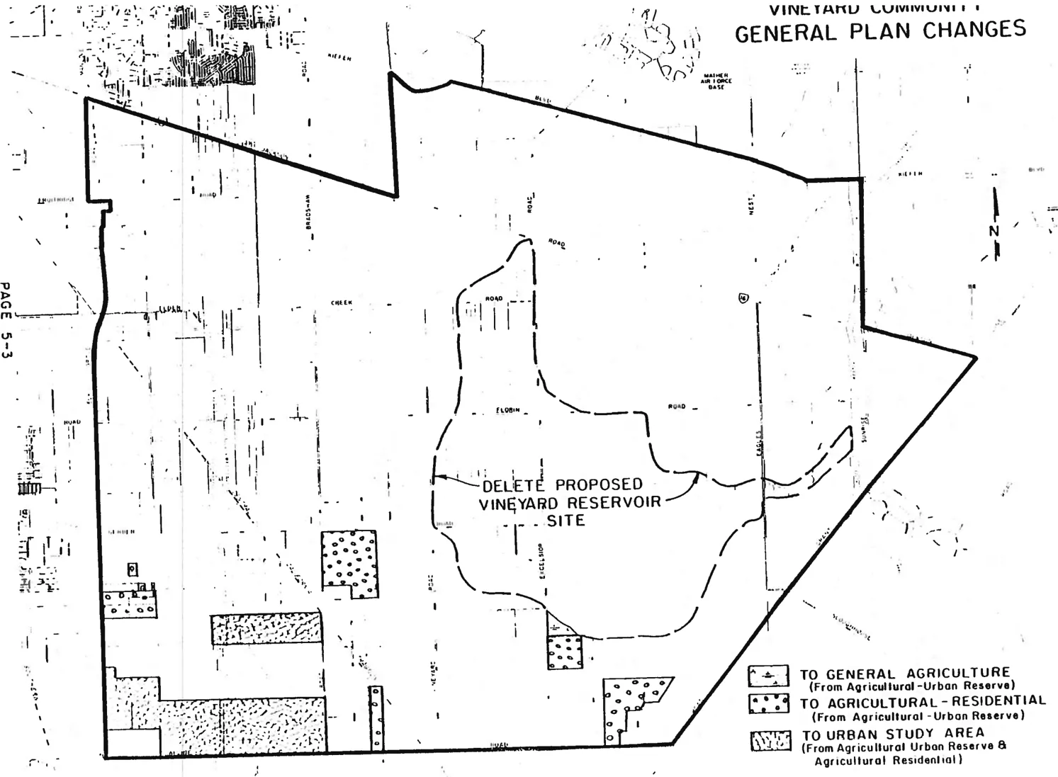
The intent of the proposed Urban Study Area (USA) General Plan category is to ensure that an area is able to support proposed development before projects are approved. The new category would differ from the current Urban Reserve category because regions designated as Urban Study Areas would be subject to an analysis of public facilities and financing requirements for anticipated development. Since the new category would require that a regional public facilities plan be done for the land within the urban Study Area, the cumulative impact of the public facilities requirements resulting from all projected development in the area would be assessed. This regional review is necessary because although one project within the Urban Study Area may result in impacts which can be mitigated, it is imperative that the impacts which will result from full urbanization of a designated Urban Study Area be analyzed.
Approximately 1,500 acres located between Elk Grove-Florin Road and Bradshaw Road have been indicated as being suitable for application of the Urban Study Area General Plan category. Following application of the USA category a detailed land use plan and a comprehensive public facilities and financing plan will be prepared for this area. This further study may well result in Community Plan amendments within the not too distant future. A more detailed discussion of the Urban Study Area General Plan category and its implications to the Vineyard Community Plan is included in Chapter Six of this text.
During the Community Plan hearing process the Board of Supervisors determined that General Plan amendment/Rezone applications for approximately 700+ acres of this area should be excluded from the USA category. This excluded area will however be part of the public facilities and financing plan to be prepared for the area. Hopefully, in a spirit of cooperation, these excluded property owners will work with the Vineyard Community Planning Advisory Council and County staff in developing a workable comprehensive land use plan which will lead to a well designed urban community.
Planned Agricultural Uses
Section titled “Planned Agricultural Uses”The Vineyard Community Plan designates the majority of the Vineyard area for agricultural uses. Soils in the Vineyard area are classified by the U.S. Soil Conservation Service as Class IV. These soils have very severe limitations that restrict the choice of crops, require very careful management, or both. The productivity of these soils is definitely limited. However, various agricultural pursuits are viable. In fact, agricultural viability could be significantly increased were a reliable economical source of irrigation water developed in the future. Community Plan policies recognize legitimate, viable agricultural uses on Class IV soils, e.g. dairies, grazing, poultry raising, vineyards, horticultural growing areas, etc.
The areas designated Permanent Agriculture are based upon the overall community needs and desires. Historical and current land uses, environmental considerations, land use constraints and expressed desires and aspirations of the community were major factors which delineated which areas should be so designated.
This designation is designed to permanently protect land which is now used, or has the potential to be used, for agricultural activities. The extent and location of this land use category is based upon a number of criteria which gain importance insofar as they support the goals and objectives of the Vineyard Community Plan. Such criteria include: existing uses; parcel size; the necessity for protecting and maintaining viable agricultural districts; and the selection of the most appropriate land use from among the feasible alternatives. This designation indicates a full commitment toward protecting and enhancing agricultural interests.
Policies and land use regulations prevent the intrusion of incompatible land uses and division of land and preclude the provision of urban services while encouraging and supporting programs which enhance the agricultural environment. The permanent agricultural zones are AG-20, AG-80 and AG-160.
Agricultural Goals and Objectives:
Section titled “Agricultural Goals and Objectives:”- To preserve the agricultural orientation and rural character of the Vineyard community.
- To promote agriculturally oriented development and lifestyles within the Vineyard community.
- To support state and local agricultural preservation and rehabilitation goals and policies.
- To encourage and support the broadening of agricultural viability criteria beyond the traditional SCS soil classifications to include but not be limited to, unit size, management practices, type of operation and water availability.
Agricultural Policies And Programs:
Section titled “Agricultural Policies And Programs:”- Support agriculturally compatible development proposals.
- Provide adequate buffering between agricultural lands and potentially incompatible land use proposals by requiring twenty acres as the minimum parcel size for new parcels adjacent to active agricultural endeavors protected by the Williamson Act.
- Maintain conformance with the County General Plan minimum parcel size requirements in all agricultural areas.
- Recognize and support the necessity and desirability of agricultural land allocation and uses as legitimate and appropriate in the Vineyard community.
- Solicit input and participation from Vineyard ranchers and farmers on all land use matters.
Planned Agricultural-Residential Uses
Section titled “Planned Agricultural-Residential Uses”This designation identifies areas which are set aside and protected for large lot rural residential uses where the keeping of animals and the raising of crops for education, recreation, or income supplementation is permitted. The intent of this category is to assure the long term viability of the rural residential uses. Parcel size and historical uses and trends are among the most important criteria used in determining the location and extent of this land use category. Agricultural-Residential districts are of sufficient size and of such configuration and location that potential conflicts with incompatible land uses are minimized and a cohesive community results. Based upon the General Plan, the minimum lot sizes are 10, 5, 2, and l acre(s). These very low density areas require and support fewer urban services than more densely populated areas. Agricultural-Residential-1 areas were used to recognize existing development; this category is not generally suited for new development unless either public water supply or sanitary sewers are available. Agricultural-Residential-2 areas most often also appear in recognition of existing development; any significant amount of new development in this land use category will require either a public water supply or sanitary sewer facilities. Agricultural-Residential-5 and -10 areas are intended to accommodate new development without public water supply or sanitary sewers.
The primary locations for this land use designation are centered around Chester Road and Dierks Road in the southeastern portion of the Community; around Grand View Road south of Gerber Road; around Carmencita Avenue east of Bradshaw Road; and around Robbins Road, Caselman Road, Leland Avenue and McCoy Avenue along the eastern boundary of the Community. A fairly large Agricultural-Residential-10 district is also located between Elk Grove-Florin Road and Bradshaw Road. This specific area remains within the Agricultural-Urban Reserve category on the County General Plan, indicating that 10 acres is the minimum parcel size for any new parcels proposed. In addition, there are several small cells of Agricultural-Residential uses in the industrial area north of Elder Creek Road. The Agricultural-Residential designation in this area is solely in recognition of historical uses, with the expansion of these cells strongly discouraged due to the potential for compatibility conflicts.
The new Agricultural-Residential areas are almost solely designated Agricultural-Residential-5 . The primary purpose of the five-acre minimum lot size is community health. Serious concern has developed over the proliferation of two-acre parcels on private wells and individual septic tank sewage systems. Information from the Sacramento County Health Agency and area residents indicates a need to control septic tank sanitation procedures because of widespread failures of these systems. While no exact distribution of septic tanks that will guarantee health safety has been established at this time, a reasonable approach is to insure as great a separation as possible and still allow a reasonable use of the land. A five-acre minimum lot size use seems the most appropriate method of resolving this problem. The plan also recommends that all new Agricultural-Residential subdivisions be served by septic tank maintenance districts. A secondary consideration is one of aesthetics; a monotonous landscape of small parcels will not contribute to the rural atmosphere of the plan area.
This land use is particularly important to the people of the Vineyard Community and to the Community’s identity. Care must be taken to insure the viability of these Agricultural-Residential areas. The following policies have been developed specifically for that purpose.
Agriculture-Residential Goals and Objectives:
Section titled “Agriculture-Residential Goals and Objectives:”- To recognize and support the necessity and desirability of Agricultural/Residential land allocation and uses as legitimate and appropriate in the Vineyard community.
- To support land use proposals which will provide for reasonable housing growth consistent with the rural atmosphere and character of the Vineyard community.
- To restrict small parcel agricultural-residential growth within the Mather Air Force Base Air Installation Compatibility Use Zones (AICUZ) for the protection of Vineyard residents and the mission of Mather Air Force Base alike.
Agricultural-Residential Policies and Programs
Section titled “Agricultural-Residential Policies and Programs”- Buffer, through incremental zoning; agricultural-residential development from industrial and agricultural land use areas.
- Parcel splits in agricultural/residential areas that will result in lots of less than 5 gross acres are not consistent with the Vineyard Community Plan, except in the following areas:
- in areas adjacent to urban growth areas; 2-acre parcels may be appropriate.
- in areas where existing parcelization is 2 acres or less; creation of new 2-acre parcels may be appropriate.
- All agricultural-residential development shall provide safe and effective access for emergency and service vehicles as well as provide adequate roadway capacity for anticipated traffic volumes.
- Water conservation, waste handling and energy-efficient designs at least to minimum County standards will be required in all agricultural-residential developments.
- All new Agricultural-Residential subdivisions with private septic systems shall be served by septic tank maintenance districts.
Planned Commercial-Industrial Uses
Section titled “Planned Commercial-Industrial Uses”The Vineyard Community area currently contains approximately 25 acres classified for commercial usage. These commercial areas are generally located at Bradshaw Road and Jackson Highway; at Bradshaw Road and Florin Road, at Bradshaw Road and Gerber Road and at Elk Grove-Florin Road and Florin Road. A substantial portion or these commercial areas are undeveloped or underdeveloped at the present time.
Based upon Vineyard’s current and projected population, it appears that the designation of additional commercial land is not warranted. However, if and when urbanization occurs in the Vineyard area, the needs of those areas will need to be thoroughly evaluated.
A number of quasi-commercial uses exist in the industrial area along the Jackson Highway. In addition, a number of agricultural-service commercial uses have been established throughout the Community. It is anticipated that these uses will continue to serve the Community and that some expansion of these uses can be expected.
A large portion of the Vineyard community is designated for industrial use. A significant part of this industrial area is specifically designated as Industrial Reserve. The Vineyard Community currently lacks public water and sewer facilities, and therefore existing industrial development is minimal. As these public services become available, which is anticipated within the next few years, increased industrialization and conversion from Industrial Reserve can be expected. In the interim however, these Industrial Reserve properties cannot be utilized for industrial purposes unless they are rezoned (i.e. M-1 or M-2). In addition, expansion of agricultural-residential uses would not be permitted without the issuance of a conditional use permit.
Due to existing constraints, e.g. aircraft accident potential, noise, etc.; the majority of future industrial uses will undoubtedly be nonintensive. Warehousing and certain employment nonintensive manufacturing uses will likely be the predominant industrial uses of the future. Community Plan policies also call for the upgrading of existing industrial uses as development occurs in the area.
Small agricultural-residential holdings will remain for some time in the developing industrial areas. Special care will need to be taken to protect these uses while they remain but to discourage their expansion.
A Community objective calls for the full development of existing industrially zoned or designated in lieu of expansion into areas not currently so zoned or designated. If current trends continue, such expansion requests can be anticipated along the Jackson Highway and possibly along Sunrise Boulevard. However, the vast acreage of vacant industrial property which currently exists in Vineyard and adjacent communities, would hardly appear to justify any large scale expansion of industrial zoning during the time frame of this Plan. In addition, the orderly development of currently designated industrial lands would undoubtedly be jeopardized.
Surface Mining can be considered a short-term industrial use of industrially designated properties with the Vineyard Community. As indicated in the Existing Land Use section of this text, approximately 5,ooo acres have had the surface mining combining General Plan land use category applied to it. Of this area approximately l,580 acres are designated for Surface Mining on the Community Plan and this acreage is almost totally under the control of aggregate companies at the present time. Only 32% of the General Plan surface mining category is reflected by the Community Plan designation and associated zoning classification, because some property owners and local residents have opposed additional properties being so designated. This opposition was clearly evident during the zoning consistency hearings held in 1980. Property owners and area residents testified that application of the Surface Mining (SM) combining zone tends to facilitate an unorderly expansion of surface mining activities, and also tends to keep down land values
The primary objective of the Surface Mining General Plan category and the Surface Mining combining land use zone is to protect valuable mineral resource areas from preclusive and incompatible land uses. It has become obvious recently that this objective has not been totally achieved. The ARMTAC (Aggregate Resources Management Technical Advisory Committee) report was approved ten years ago and follow-up implementation policies, codes and procedures were adopted shortly thereafter. Since that time significant changes, including increased urban pressures, have occurred.
Due to the changes which have occurred, the Board of Supervisors recently initiated a study which will in essence update the 1974 ARMTAC report. This study, when completed, may involve new policies and procedures relating to aggregate resources, which could in turn require amendments to the Vineyard Community Plan.
Commercial/Industrial Goals and Objectives:
Section titled “Commercial/Industrial Goals and Objectives:”- To develop industrially designated areas in a manner that minimizes negative impacts upon the Vineyard community.
- To encourage full development of existing industrially zoned or designated lands in lieu of expansion into areas not currently industrially zoned or designated.
- To encourage full utilization of industrially zoned lands by upgrading existing development.
- To oppose rezoning to industrial (M-l and M-2), areas within the General Plan Surface Mining Combining category where General and/or Community Plan policies indicate other zones or land use designations may be more appropriate (e.g. IR, UR, AG).
Commercial/Industrial Policies and Programs:
Section titled “Commercial/Industrial Policies and Programs:”- Industrial land use proposals should be carefully reviewed to ensure compliance with AICUZ and APZ compatibility standards.
- Industrial proposals should include efficient site plans which reflect the rural character of Vineyard, include measures to ensure efficient public service facility provision, and avoid potential compatibility conflicts.
- Industrial proposals should be accompanied by a public services plan, the scope of which will depend on the extent and complexity of the proposal.
- Commercial/industrial development must be adequately buffered from adjacent residential or agricultural uses with screening; open space, less dense development, or other means.
- Employment intensive industrial/commercial development will be opposed within the Mather Air Force Base accident potential zones (APZ’s).
Planned Transportation Facilities
Section titled “Planned Transportation Facilities”The Sacramento County Major Street and Highway Plan indicates that a number of streets and highways in the Vineyard Community are planned for upgrading prior to the year 2000, which may be within the time frame of this Plan (Figure 5-2). The Major Street and Highway Plan specifically indicates that Bradshaw Road, Fruitridge Road, Excelsior Road, and a portion of Kiefer Boulevard will be upgraded to arterial status. Florin Road, between Elk Grove-Florin Road and Bradshaw Road will be upgraded to thoroughfare status and Elk Grove-Florin Road and Sunrise Boulevard will become expressways.
With the development of major employment centers in the eastern and southern portions of the County, the above roadways, or other roadways within the Vineyard Community, could require upgrading during the planning period. Grant Line Road and Calvine Road have considerable potential for connecting these employment centers and could become major roadways in the future. The recently approved East Area Transportation Study, as well as Caltrans Route Concept Report, has identified the long-term need for a freeway connection between U.S. 50 and State Route 99. While the precise location of such a “beltline” freeway is far from being determined, it would definitely have an impact on the Vineyard Community. The reality of such a “beltline” freeway is undoubtedly beyond the time frame of this plan.
Transit service is not currently planned for the Vineyard Community. However, with potential urbanization and increased industrialization, transit service will likely be implemented during the planning period. Transit financing for the Regional Transit District is the major obstacle.
Other Planned Public Facilities and Services
Section titled “Other Planned Public Facilities and Services”The majority of the Vineyard Community will not experience significant increases in public facilities and/or services during the life of this plan. Two notable exceptions however are the industrial area in the northwest portion of the Community and the projected urban area in the southwest section of Vineyard. These two areas will require and realize increased public facilities and services as industrialization and urban residential development occurs.
Public water and sewer facilities will likely be extended to these two areas within the next few years. Based upon negotiations currently occurring with the City of Sacramento, a surface water supply seems fairly likely, which is in keeping with the policies of this plan. The specifics regarding how this surface water would be provided are currently being analyzed. Should public water not be provided to the industrial area by one of the measures currently under study, property owners along Vineyard’s western boundary will likely annex to the City of Sacramento to obtain such services.
As indicated previously, public sewer service would need to be extended to developing industrial areas and any potential urban residential areas. The provision of sewer service is dependent upon annexation to the Regional Sanitation District. Capacity currently appears to be available to serve any anticipated development in the Vineyard area during the life of this plan.
The provision of adequate school facilities within the Elk Grove Unified School District has become of critical concern in recent years due to planned urban residential growth. Any residential expansion in the Vineyard area will only tend to compound existing problems. The entire school financing issue must be addressed prior to any urban residential growth within the Vineyard Community.
FIGURE 5-2: MAJOR STREET & HIGHWAY PLAN
Section titled “FIGURE 5-2: MAJOR STREET & HIGHWAY PLAN”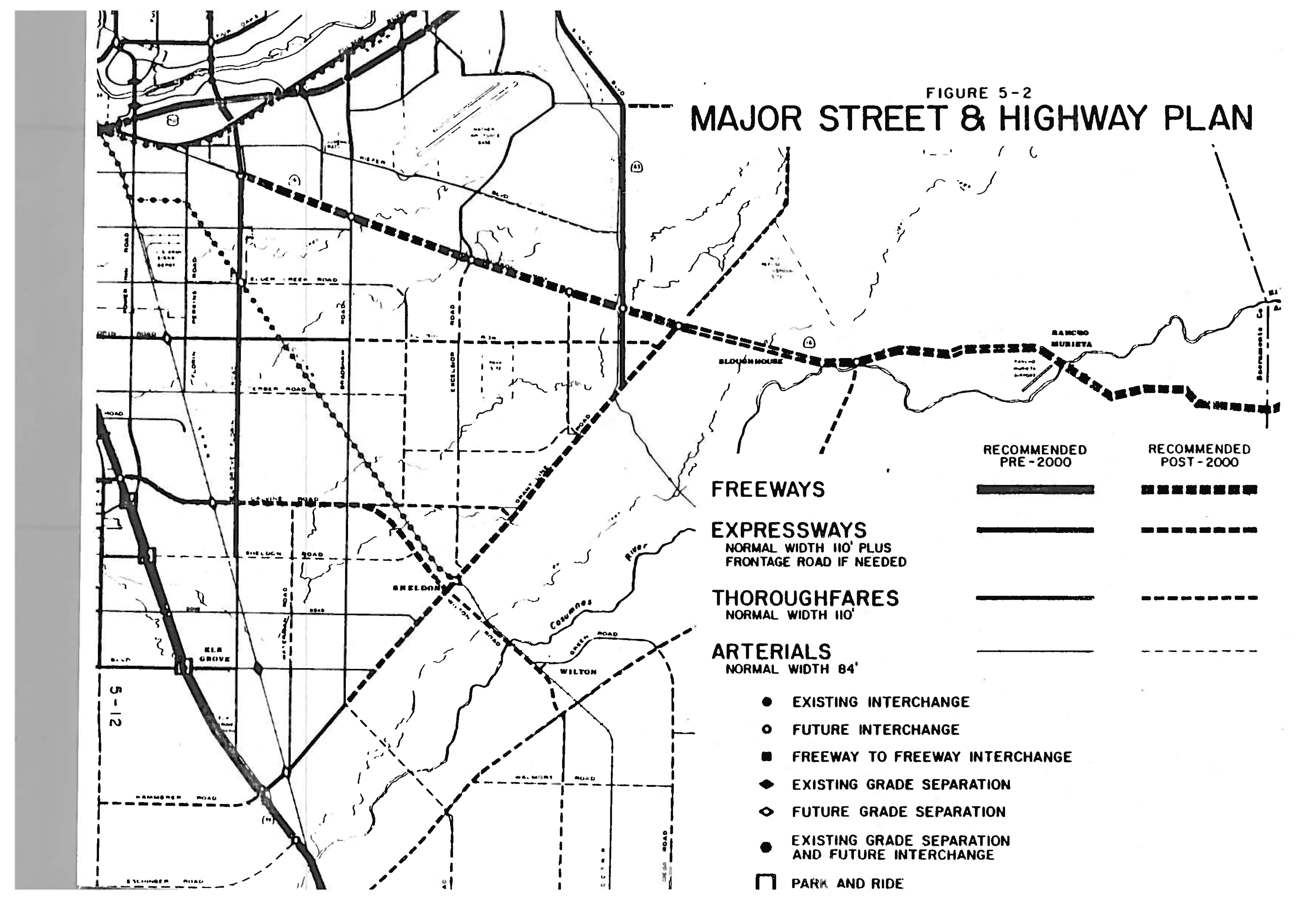
Public Facilities/Services Goals and Objectives:
Section titled “Public Facilities/Services Goals and Objectives:”- To provide adequate and appropriate infrastructure and public services to all residents and businesses of the Vineyard community.
- To provide public protection services with acceptable response times for Vineyard residents.
Public Facilities/Services Policies and Programs:
Section titled “Public Facilities/Services Policies and Programs:”- Consider the effects on the water table when reviewing future development in the plan area.
- Restrict the premature or unnecessary extension of public sewerage systems into or through open, undeveloped areas which would promote noncontiguous development.
- Restrict urban and rural development from encroaching into the 100-year floodplain.
- Require all residential development proposals submitted to the County for approval be coordinated with the school district.
- Require development and maintenance of an adequate fire suppression water supply for all new development.
- All types of urban development proposals must be accompanied by a detailed public services plan and specific timing and funding programs for the implementation and maintenance of services.
CHAPTER 6: FUTURE URBANIZATION
Section titled “CHAPTER 6: FUTURE URBANIZATION”Urban Alternatives Study
Section titled “Urban Alternatives Study”The Urban Alternatives Study, recently completed by Sacramento County, resulted in a recommendation as to which areas within the County were most suitable for urban expansion. The purpose of the study was to ensure that land area requirements to meet growth projections will be met for the time period 1985-2005. Approximately 8,600 acres outside the existing urban area will be required to accommodate 41,000 housing units during the 1985-2005 time period. These figures include a 25% land oversupply to reflect County General Plan policy. Specific potential expansion areas were selected after a constraints analysis which evaluated the following constraints per area: noise, Aerojet propellant hazard zone, sewer treatment plant buffer, flood hazard areas, proposed dams and reservoirs, toxic contamination, aggregate resources, land conservation contracts, agricultural cropland, prime agricultural land, public use airports, overhead utility transmission lines and established small parcel agricultural-residential neighborhoods.
Urban Study Area General Plan Category
Section titled “Urban Study Area General Plan Category”As the Urban Alternatives Study focused on specific potential expansion areas it became necessary to examine suitable General Plan categories for the identified areas, and it was determined that a new General Plan category was necessary for those areas where urban expansion was recommended. The Urban Study Area General Plan category will provide a mechanism with which the County may determine the public facility requirements and the associated financing mechanisms for residential and support commercial development in a particular urban expansion area. It will also provide for the analysis of the area’s ability to meet the requirements prior to land development project approvals.
Future Urbanization in Vineyard
Section titled “Future Urbanization in Vineyard”A portion of the Vineyard area which was included in the Urban Alternatives analysis has been designated for urban expansion as a result of its proximity to urban or planned urban areas and the limited constraints to development in the area.
The area described as West Vineyard, one of the ten analysis areas, is the area bounded by a property line extending west from the terminus of Rogers Road on the north, Calvine Road on the south, Bradshaw Road on the east and Elk Grove-Florin Road on the west.
Because the West Vineyard analysis area was designated as suitable for urban expansion, the area has been placed in the Urban Study Area General Plan Category, with the exception of approximately 700+ acres which have General Plan amendment/Rezone applications pending. Consequently, a land use plan and public facilities/financing program will be required. These studies are expected to take approximately one year to complete. Vineyard area studies will use the goals and objectives, policies and programs and land use assumptions of this plan in developing the required Urban Study Area land use plan and public facilities/financing program. Listed below are the Future Urbanization Goals and Objectives and Policies and Programs.
Future Urbanization Goals and Objectives
Section titled “Future Urbanization Goals and Objectives”- To encourage infilling of property and the development of urban growth areas adjacent or contiguous to existing developed areas rather than permitting leapfrogging of urban residential development into primarily agricultural areas.
- To preclude expansion of urban residential growth into the Mather Air Force Base Air Installation Compatibility Use Zones (AICUZ) for the protection of Vineyard residents and the mission of Mather Air Force Base alike.
- To provide a wide range of housing types and living environments for present and future residents of the Vineyard community.
- To ensure contiguous urban development which will maximize public service facility use and efficiency.
Future Urbanization Policies and Programs
Section titled “Future Urbanization Policies and Programs”- Buffer, through incremental zoning, residential development from industrial and agricultural land use areas.
- Urban residential development will only be considered in those areas contiguous to approved urban uses and designated for future urban growth, and only when negative impacts upon the Vineyard community are mitigated to the greatest extent possible.
- All types of urban development proposals must be accompanied by a detailed public services plan and specific timing and funding programs for the implementation and maintenance of services.
- Urban developers shall provide public sewer and surface water facilities and shall bear the full cost of providing these facilities within the proposed development and a fair share of any associated costs outside the development.
- All urban development and nonagricultural water intensive use proposals must include provisions for surface water; or provide specific conjunctive use programs which offset the amount of groundwater overdraft.
- Water conservation, waste handling and energy-efficient designs at least to minimum County standards will be encouraged in all residential developments.
- Urban land use proposals should minimize encroachment upon open space areas and maximize infrastructure effectiveness through measures such as clustered design and contiguous development.
CHAPTER 7: IMPLEMENTATION
Section titled “CHAPTER 7: IMPLEMENTATION”This section summarizes the guidelines and methods to be utilized in implementing the Vineyard Community Plan. The plan for this community is self-implementing to a large degree through adoption of the plan by the Board of Supervisors and by the application of consistent zoning. The policies and programs of the Vineyard Community Plan will be effectuated through ongoing administrative procedures and future special studies.
Zoning Consistency
Section titled “Zoning Consistency”During the spring of 1985 the Policy Planning Commission and Board of Supervisors held public hearings to implement the Community Plan through zoning consistency hearings. The land use zones and the Community Plan are now considered consistent with the County General Plan. It must be recognized, however, that there will not always be a one-to-one relationship between zoning and the General Plan, as the historical use of property and peculiarities of the parcel are also given consideration in determining consistency with the General Plan.
Policy Implementation
Section titled “Policy Implementation”This plan represents policy guidelines for governing the development of the community throughout the planning period. The policies of the Vineyard Community Plan represent position statements of the Board of Supervisors as well as the residents of the Vineyard Community. Community Plans are designed to be utilized as a day-to-day guide for land use decisions within the study area. The policies included in this plan are not to be regarded as mere reference material but should serve as a mandate for specific courses of action to be undertaken by the County, public and private agencies, and individuals. These policies will be implemented through normal ongoing administrative procedures, future special studies and the long-term planning programs of agencies operating in the plan area. The policies of the Vineyard Community Plan are summarized at the end of this section.
Future Special Studies
Section titled “Future Special Studies”As indicated in Chapter Six of this Plan, the Board of Supervisors has designated approximately 800 acres in the southwestern portion of the Vineyard Community as an Urban Study Area. As part of the Urban Study Area analysis a land use plan and a public facilities financing plan will be developed. Adjacent private applications will be incorporated into these studies and become a part of these plans. This will subsequently result in specific amendments to the Vineyard Community Land Use Plan and preparation of a supplement to the Community Plan text.
Community Plan Update
Section titled “Community Plan Update”The Vineyard Community Plan should be reevaluated and updated at five to seven year intervals. In the Community Plan updating process, all factors which were originally considered in the development of this Plan will be reevaluated. In addition, the various policies will be reconsidered to ensure their continued relevancy and appropriateness. Proposed amendments to the Community Plan land use map and policies will be evaluated to ensure the integrity of the plan is maintained.
Summary of Policies
Section titled “Summary of Policies”Various portions of this plan text contain policy statements that pertain to individual land uses. For ease of reference, all the policies and programs of the Vineyard Community Plan are listed here.
Natural Environmental Resources Policies and Programs
Section titled “Natural Environmental Resources Policies and Programs”NER-1.
Section titled “NER-1.”Encourage land use proposals which reduce reliance on the automobile by offering area residents alternative commute modes, including public transit.
NER-2.
Section titled “NER-2.”Support coordination between local, state and federal agencies in the provision of flood protection and quality water within the Vineyard community.
NER-3.
Section titled “NER-3.”Protect natural areas from the effects of urbanization through the utilization of appropriate zoning techniques which support local, state and federal preservation policies.
NER-4.
Section titled “NER-4.”Protect vernal pools and potential endangered species as the Sacramento Orcutt Grass by evaluating development project sites on a case-by-case basis for the presence of vernal pools and inventorying those sites where pools are found.
NER-5.
Section titled “NER-5.”Encourage the development of linear parkways along stream channels, within floodplains, and within power transmission easements for environmentally compatible recreation facilities and open space.
NER-6.
Section titled “NER-6.”Require buffering and appropriate screening between commercial/industrial development and residential land use and between commercial/industrial development and agricultural uses.
NER-7.
Section titled “NER-7.”Continue to utilize the Surface Mining Combining Zone for the preservation of aggregate resources and for the protection of area residents through mitigation provisions contained within that zone.
Agricultural Policies and Programs
Section titled “Agricultural Policies and Programs”Support agriculturally compatible development proposals.
Provide adequate buffering between agricultural lands and potentially incompatible land use proposals by requiring twenty acres as the minimum parcel size for new parcels adjacent to active agricultural endeavors protected by the Williamson Act.
Maintain conformance with the County General Plan minimum parcel size requirements in all agricultural areas.
Recognize and support the necessity and desirability of agricultural land allocation and uses as legitimate and appropriate in the Vineyard community.
Solicit input and participation from Vineyard ranchers and farmers on all land use matters.
Agricultural-Residential Policies and Programs
Section titled “Agricultural-Residential Policies and Programs”Buffer, through incremental zoning, agricultural-residential development from industrial and agricultural land use areas.
Parcel splits in agricultural/residential areas that will result in lots of less than 5 gross acres are not consistent with the Vineyard Community Plan, except in the following areas:
- in areas adjacent to urban growth areas; 2-acre parcels may be appropriate.
- in areas where existing parcelization is 2 acres or less; creation of new 2-acre parcels may be appropriate.
All agricultural-residential development shall provide safe and effective access for emergency and service vehicles as well as provide adequate roadway capacity for anticipated traffic volumes.
Water conservation, waste handling and energy-efficient designs at least to minimum County standards will be encouraged in all agricultural-residential developments.
All new Agricultural-Residential subdivisions with private septic systems shall be served by septic tank maintenance districts.
Commercial/Industrial Policies and Programs
Section titled “Commercial/Industrial Policies and Programs”Industrial land use proposals should be carefully reviewed to ensure compliance with AICUZ and APZ compatibility standards.
Industrial proposals should include efficient site plans which reflect the rural character of Vineyard, include measures to ensure efficient public service facility provision, and avoid potential compatibility conflicts.
Industrial proposals should be accompanied by a public services plan, the scope of which will depend on the extent and complexity of the proposal.
Commercial/industrial development must be adequately buffered from adjacent residential or agricultural uses with screening, open space or less dense development, or other means.
Employment intensive industrial/commercial development will be opposed within the Mather Air Force Base accident potential zones (APZ’s).
Public Facilities/Services Policies and Programs
Section titled “Public Facilities/Services Policies and Programs”Consider the effects on the water table when reviewing future development in the plan area.
Restrict the premature or unnecessary extension of public sewerage systems into or through open, undeveloped areas which would promote noncontiguous development.
Restrict urban and rural development from encroaching into the 100-year floodplain.
Require all residential development proposals submitted to the County for approval be coordinated with the school district.
Require development and maintenance of an adequate fire suppression water supply for all new development.
All types of urban development proposals must be accompanied by a detailed public services plan and specific timing and funding programs for the implementation and maintenance of services.
Future Urbanization Policies and Programs
Section titled “Future Urbanization Policies and Programs”Buffer, through incremental zoning, residential development from industrial and agricultural land use areas.
Urban residential development will only be considered in those areas contiguous to approved urban uses and designated for future urban growth, and only when negative impacts upon the Vineyard community are mitigated to the greatest extent possible.
All types of urban development proposals must be accompanied with a detailed public services plan and specific timing and funding programs for the implementation and maintenance of services.
Urban developers shall provide public sewer and surface water facilities and shall bear the full cost of providing these facilities within the proposed development and a fair share of any associated costs outside the development.
All urban development and nonagricultural water intensive use proposals must include provisions for surface water; or provide specific conjunctive use programs which offset the amount of groundwater overdraft.
Water conservation, waste handling and energy-efficient designs at least to minimum County standards will be encouraged in all residential developments.
Urban land use proposals should minimize encroachment upon open space areas and maximize infrastructure effectiveness through measures such as clustered design and contiguous development.