Community Planning Advisory Council (CPAC) Bylaws
Clerk of the Board of Supervisors of Sacramento County
Community Planning Advisory Council Bylaws
Section titled “Clerk of the Board of Supervisors of Sacramento County Community Planning Advisory Council Bylaws”Adopted March 1975
Amended May 20, 2025
1. NAME:
Section titled “1. NAME:”The Community Planning Advisory Councils, herein referred to as Council or Councils, shall be known by their names as provided in their establishing Resolutions.
2. ADVISORY DUTIES:
Section titled “2. ADVISORY DUTIES:”The Councils shall have the authority to do all of the following:
- Review and comment, within the context of neighborhood compatibility, upon proposed planning projects located in their planning area.
- Recommend amendments to existing community goals and plans.
- Comment upon the implementation of community plans and other pertinent plans.
- Such other matters as the Board of Supervisors deems appropriate.
3. AREA OF JURISDICTION:
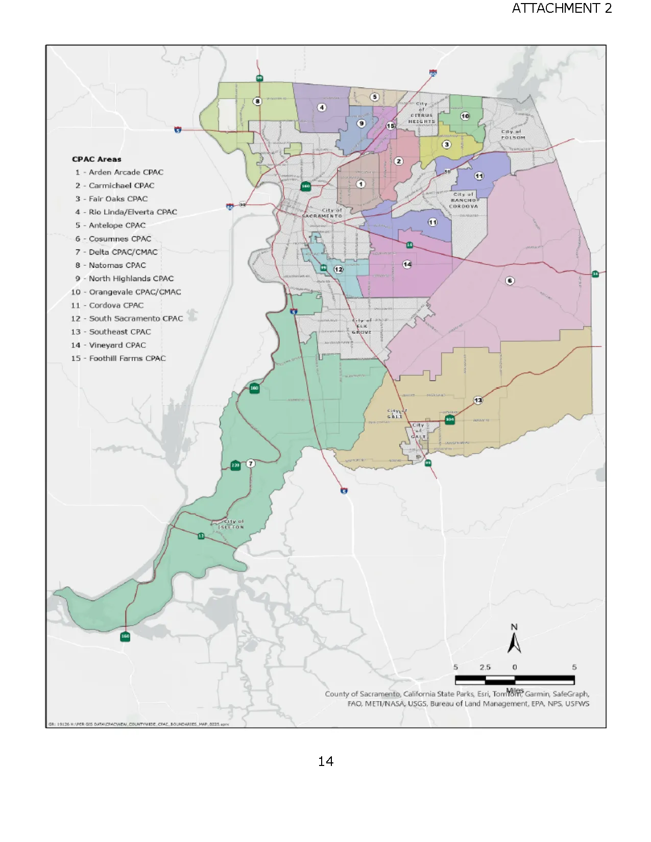
Section titled “3. AREA OF JURISDICTION:”The Councils shall have jurisdiction for matters in their planning areas. Descriptions of said planning areas are set forth in Attachment “1” attached hereto. A map of said planning area boundaries is provided in Attachment “2” attached hereto.
4. MEMBERSHIP:
Section titled “4. MEMBERSHIP:”4.1 Size:
Section titled “4.1 Size:”- The number of members to each Council shall be seven (7).
- Notwithstanding subdivision (a), the number of members to the Delta Citizen’s Municipal Advisory Council shall be eleven (11).
4.2 Residency:
Section titled “4.2 Residency:”Each member of a Council shall be a resident of its planning area as provided in the Council’s establishing Resolution.
4.3 Appointment:
Section titled “4.3 Appointment:”Members of a Council shall be appointed by the Board of Supervisors.
4.4 Term of office:
Section titled “4.4 Term of office:”Each member shall serve a two-year term.
- No member shall serve more than three consecutive terms, but a member may be reappointed if such member has not served within the year prior to such reappointment.
- Any person appointed to fill less than half of an unexpired existing term, may serve three terms following the expiration of the existing term.
- Any person appointed to fill half or more of an expired existing term, may serve two terms following the expiration of the existing term.
- The first members of a Council shall determine by lot at their first meeting which of them shall serve for one or two years respectively so that to the extent possible, an equal number of terms will expire each year.
- Notwithstanding any other provisions of Section 4.4, in the event the Board of Supervisors determines that there are insufficient applicants to fill a vacancy on a Community Planning Advisory Council, the Board may either: (1) terminate existence of the Council; or (2) extend for a period of one year the term or tenure of the member or members of the Council whose cessation of membership creates the vacancy or vacancies, for the purpose of further solicitation of applications for appointment. At the conclusion of the one-year period, if there are still insufficient applicants, the Board may alternatively terminate the Council or extend the term of preceding members by additional periods of one year for further solicitation of applicants.
4.5 Attendance:
Section titled “4.5 Attendance:”- In the event a member is unable to attend a meeting, the member shall notify the Chairperson and the Office of the Clerk of the Board of Supervisors prior to the meeting to constitute an excused absence.
- If a member has three unexcused absences annually, the Office of the Clerk of the Board of Supervisors will initiate a letter to the member asking them to reaffirm in writing their intent to remain active. Failure to reaffirm within 30 days following the letter constitutes forfeiture of Council membership.
- If a member has four absences annually, whether they be excused or unexcused, membership is automatically forfeited.
- Notwithstanding subdivisions (a) through (c), a member of the Board of Supervisors may grant a Council member a leave of absence, not to exceed four consecutive regular monthly Council meetings, when good cause is established. Said leave of absence may only be granted when the affected Council member submits a written request to the Chairperson and the Office of the Clerk of the Board of Supervisors. Notification of a grant of leave shall be transmitted in writing to the Council chairperson, assigned Council staff, affected member and the Office of the Clerk of the Board of Supervisors.
- A member that has forfeited membership due to absences may reapply to the Council by submitting an Application for Appointment to Sacramento County Boards, Commissions and Committees to the Office of the Clerk of the Board of Supervisors.
4.6 Conflict of Interest:
Section titled “4.6 Conflict of Interest:”Within 30-days upon assuming office and continuously throughout membership, each member shall comply with regulations pursuant to the Sacramento County Conflict of Interest Code of the Boards, Committees, Commissions and Councils.
5. ORGANIZATION:
Section titled “5. ORGANIZATION:”5.1 Officers:
Section titled “5.1 Officers:”Each Council shall have the following officers that are to be elected annually:
- Chairperson
- Vice Chairperson
5.2 Officer Responsibilities:
Section titled “5.2 Officer Responsibilities:”The Chairperson:
- Shall preside over meetings of the Council.
- Shall impose reasonable time limits on any speakers in order to effectuate the orderly transaction of Council business.
- Shall act as a liaison with County staff.
- Shall be responsible for assigning Council members to research projects being heard by the Council.
- Shall be responsible for notifying the Clerk of membership forfeiture as a result of absences.
- May delegate any of the aforementioned duties and responsibilities to another member, but shall retain the responsibility for performance.
The Vice Chairperson:
- Shall be responsible for reporting on the status of projects of interest to the Council.
- Shall assume the duties of the Chairperson in their absence.
5.3 Officer Elections:
Section titled “5.3 Officer Elections:”If a council officer position shall become vacant, an election will be held at the next regular Council meeting to elect an officer.
5.4 Officer Removal:
Section titled “5.4 Officer Removal:”An elected officer may be removed from office by a two-thirds vote of the appointed Council membership.
6. OPERATION:
Section titled “6. OPERATION:”6.1 Council Meetings:
Section titled “6.1 Council Meetings:”All Council meetings shall be open to the public, pursuant to the Ralph M. Brown Act (Government Code 54950 et seq.) and shall be held within their planning areas.
- The location and time of the meetings shall be agreed upon by the Office of Planning and Environmental Review and the Office of the Clerk of the Board of Supervisors.
- Items on the meeting agenda are to be set by the Office of Planning and Environmental Review and finalized in coordination with the Office of the Clerk of the Board of Supervisors.
6.2 Quorum:
Section titled “6.2 Quorum:”A majority of the appointed members present shall constitute a quorum of a Council.
- A majority of the quorum shall constitute sufficient votes of the members for the transaction of Council business.
- When there is no quorum, the Council may provide comments to be forwarded to the Office of Planning and Environmental Review without a formal advisory recommendation to the final hearing body.
6.3 Order of Business:
Section titled “6.3 Order of Business:”The Order of Business for Council meetings shall be as set forth below.
- Introduction
- Role of the Council
- Roll Call & Quorum Determination
- Agenda Items
- Presentation by County Staff Representative
- Presentation by Applicant
- Questions by the Council
- Public Comments
- Council Deliberations
- Council Vote on Project
- Other Business & Announcements
- Adjournment
6.4 Continuances:
Section titled “6.4 Continuances:”- Any item on the agenda may be continued a maximum of one time by the Council; however, the applicant or applicant’s representative may request a further continuance such as to address community concerns and comments.
- Notwithstanding subdivision (a), housing projects may not be continued in order to comply with State law setting limits on the number of public meetings on a housing project.
6.5 Action on the Project:
Section titled “6.5 Action on the Project:”The Clerk of the Board shall be the official record keeper and custodian of records for each CPAC. The responsibilities during Council meetings for recording action on the project shall be as set forth below.
- All members of the Council present shall have and cast one (1) vote unless they make a declaration to abstain or recuse. Said vote shall be for the purpose of making an advisory recommendation to support, oppose, or provide other comments.
- Any declaration to abstain shall include an explanation for the abstention, which shall be duly recorded.
- Members shall recuse themselves from proceedings on any item where they have a conflict of interest or where there is the potential for a conflict of interest. In the event of a conflict or potential conflict, the following steps shall be taken:
- The member(s) with the conflict of interest shall declare that a conflict exists when the item is read into the record, and such declaration shall be duly recorded.
- The member(s) shall not make any further comment on the item and shall leave the room until all proceedings pertaining to the item have concluded.
6.6 Council Information:
Section titled “6.6 Council Information:”The Councils shall maintain up to date contact information of Council members which shall be forwarded to the Office of the Clerk of the Board of Supervisors.
6.7 Rules for Public Testimony:
Section titled “6.7 Rules for Public Testimony:”The Chair may establish rules for public testimony at the outset of the meeting. These rules may limit the typical three-minute time allotted for each public speaker. Additional limitations on the amount of individual speaker time and/or limits on the amount of total time for public testimony on any one item may also be set by the Chair particularly in the event that a lengthy agenda or controversial item(s) may cause the meeting to extend significantly beyond regular hours or exceed the room availability. Any such limitations should ensure that due process is provided to all those wishing to speak, whether in support of or opposition to the matter. Furthermore, the Chair is authorized to modify public comment requirements so as to ensure that housing projects subject to State limitations on the number of hearings are prioritized and continuances are minimized.
6.8 Other Boards and Commissions:
Section titled “6.8 Other Boards and Commissions:”If a CPAC member is required to sit on a Board or Commission for another entity and nominations are required, nominations shall be submitted to the Chair during a duly noticed meeting and the nominee receiving the majority vote shall be appointed.
7. AMENDMENTS:
Section titled “7. AMENDMENTS:”The Office of the Clerk of the Board of Supervisors, the Office of Planning and Environmental Review, County Counsel, and the Office of the County Executive are authorized to initiate amendments to the provisions in these Bylaws. Proposed amendments must be ratified by the Board of Supervisors for effectuation.
8. INCONSISTENT PROVISIONS:
Section titled “8. INCONSISTENT PROVISIONS:”Chapter 2.36 of the Sacramento County Code and the provisions set forth in these Bylaws shall supersede any inconsistent provisions in any and all previously adopted Rules for Conduct of Business or Bylaws of County Planning Advisory Councils.
Attachments
Section titled “Attachments”- ATT 1 Description of CPAC Planning Areas
- ATT 2 Map of CPAC Areas
Attachment 1: CPAC Planning Areas
Section titled “Attachment 1: CPAC Planning Areas”The following is a set of descriptions of each council’s planning area of jurisdiction as established and amended through Resolutions approved by the Board of Supervisors. Citations of such Resolutions are included.
Antelope Community Planning Advisory Council
Section titled “Antelope Community Planning Advisory Council”THAT AREA bounded on the westerly side, 28th Street to Elverta Road and Dry Creek to the County line; on the north, the Placer County and Sacramento County Boundary; on the east, the Southern Pacific Company’s tracks south to Antelope Road; on the south, Antelope Road (U Street) from the Pacific Company’s tracks west to 28th Street.
(RES No. 90-1193)
Arden-Arcade Community Planning Advisory Council
Section titled “Arden-Arcade Community Planning Advisory Council”THAT AREA bounded on the north by Auburn Boulevard from Howe Avenue to Walnut Avenue, on the east by Walnut Avenue to Fair Oaks Boulevard and Arden Way, east on Arden Way to the American River; on the south by the American River to the Sacramento City limits at Cal Expo Center and Ethan Way; on the west by Ethan Way to Arden Way and Howe Avenue, from Arden Way to Auburn Boulevard at Marconi Avenue. (RES No. 75-1225; and RES 92-0335)
Carmichael Community Planning Advisory Council
Section titled “Carmichael Community Planning Advisory Council”THAT AREA bounded on the intersection of Manzanita Avenue and the City of Citrus Heights boundary, heading east along the City of Citrus Heights boundary, then south on San Juan Avenue to the City of Rancho Cordova boundary. Then south along the City of Rancho Cordova boundary then west along the American River to a point at and along a line between Regency Circle and Marlborough Way northwest to American River Drive. Then following the western property line of Jesuit High School, to a point at and along a line between Lantern Court and Genesee Court northwest to Fair Oaks Boulevard. Then north on Mission Avenue and its northerly extension past Engle Road then following the western boundary of Gibbons Community Park, then northwest on Cypress Avenue, then east on Winding Way. At Valhalla Drive the boundary follows the back parcel line of properties abutting Arcade Creek, then north on Garfield Avenue, then east on Madison Avenue, then north on Manzanita back to the point of beginning. (RES No. 75- 1226, RES No. 2001-0164)
Cordova Community Planning Advisory Council
Section titled “Cordova Community Planning Advisory Council”THAT AREA bounded on the North by the American River and the Folsom City Limits; on the East by Prairie City Road, White Rock Road, and Grant Line Road; on the South by Douglas Road to Sunrise Boulevard to Kiefer Boulevard to Excelsior Road to Jackson Highway; and on the West by South Watt Avenue and Manlove Road; and expecting therefrom that area within the City of Rancho Cordova. (RES 75-1197; RES No. 94- 0478; and RES No. 2004-0573)
Cosumnes Community Planning Advisory Council
Section titled “Cosumnes Community Planning Advisory Council”THAT AREA bounded by Highway 50 (El Dorado Freeway) on the north; the El Dorado and Amador County Line on the east; the southerly boundary of the Elk Grove Unified School District on the south; and the Highway 50/99 and the eastern boundaries of the City of Rancho Cordova and the City of Elk Grove and Vineyard communities on the west.
(RES No. 79-1026; RES No. 2000-0887; RES No. 2002-1567; and RES No. 2004-0051)
Delta Citizens Municipal Advisory Council
Section titled “Delta Citizens Municipal Advisory Council”THAT AREA bounded on the north by a line extended westerly from the westerly terminus of Elk Grove Boulevard to the Sacramento County Line; on the east by the I-5 Freeway; on the west and on the south by the Sacramento County Line. (RES No. 83-1053)
ALSO THAT AREA bounded by the Union Pacific Railroad Tracks on the east, Elk Grove Blvd and the Stonelake Wildlife Reserve on the south, Interstate 5 on the west and the Regional Wastewater Treatment Plant on the north. (RES No. 2004-1058 to add above additional area)
Fair Oaks Community Planning Advisory Council
Section titled “Fair Oaks Community Planning Advisory Council”THAT AREA bounded by the American River on the south, San Juan Avenue on the west, Madison Avenue on the north, and Blue Ravine (the large drainage area draining toward Mississippi Bar on the American River) on the east. (RES No. 75-538)
Foothill Farms Community Planning Advisory Council
Section titled “Foothill Farms Community Planning Advisory Council”THAT AREA the intersection of Walerga Road and Antelope Road heading east to the City of Citrus Heights City boundary, then south along the City of Citrus Heights City boundary to Auburn Boulevard, then southwest on Auburn Boulevard to Manzanita Avenue. Then south on Manzanita Avenue to Madison Avenue. West on Madison Avenue, then South on Garfield Avenue. Then the boundary follows Arcade Creek downstream to Winding Way and continues west to the Sacramento City boundary. Then northeast on Sacramento City boundary continuing to the centerline of Interstate 80, then northeast on Interstate 80 to a point parallel to the southern terminus of Hillsdale Boulevard, then north to the centerline of Hillsdale Boulevard, then west on Madison Avenue, then north on Jackson Street to the Union Pacific railway line. Then northeast on the railway line to the southern property line of the parcels at 4700 and 4701 Keema Avenue, then north along the eastern property line of Hillsdale Elementary School, west on Kingbird Way, north along the eastern property line of the parcels on Guthrie Street, then west along northern property line of the parcels on Don Julio Boulevard to Walerga Road, then north on Walerga Road to the point of beginning, including the parcels adjacent to Walerga Road to the west.
Natomas Community Planning Advisory Council
Section titled “Natomas Community Planning Advisory Council”THAT AREA bounded by the Sutter-Sacramento County line on the North to the Western Pacific on the East then South along the Western Pacific to San Juan Roan (projected), West on San Juan Road to Truxel Road, South on Truxel Road (projected) to the American River, then along the American River to the Sacramento River, and along the Sacramento River to the Sutter-Sacramento County Line on the North.
(RES No. 75-1126)
North Highlands Community Planning Advisory Council
Section titled “North Highlands Community Planning Advisory Council”THAT AREA bounded the intersection of 28th Street and U Street heading east to where U Street turns into Antelope Road and continuing east to Walerga Road, then south on Walerga Road to Antelope Road, excluding the parcels adjacent to Walerga Road on the West. Then east along the north property line of the parcels on Don Julio Boulevard, then south along the eastern property line of the parcels on Guthrie Street, then east on Kingbird Way, then south along the eastern property line of Hillsdale Elementary School. Then southeast along the southern property line of the parcels at 4700 and 4701 Keema Avenue to the Union Pacific railway line. Then southwest on the railway line to A Street, then south to Jackson Street, then east on Madison Avenue, then south on Hillsdale Boulevard to Interstate 80. West on Interstate 80 to the City of Sacramento boundary. Follow the City of Sacramento boundary west, then north to Ascot Avenue, then north following the McClellan Park property boundary to 28th Street, then north on 28th Street to the point of beginning. (RES No. 75-1224, RES No. 82-429 and RES No. 90- 1194)
Orangevale Community Planning Advisory Council
Section titled “Orangevale Community Planning Advisory Council”THAT AREA bounded by the Placer County line on the North, the City Limits of the City of Folsom on the East, Madison Avenue on the South, and Kenneth Avenue and Wachtel Way on the West. (RES No. 90-1389)
Rio Linda/Elverta Community Planning Advisory Council
Section titled “Rio Linda/Elverta Community Planning Advisory Council”THAT AREA bounded on the North by the Sutter-Placer and Sacramento County Boundary, on the West by the Western Pacific Railroad and Natomas East Main drainage Canal, on the south by the City of Sacramento and the East by McClellan Air Force Base, 28th Street, and Dry Creek. (RES No. 75-1228)
South Sacramento Community Planning Advisory Council
Section titled “South Sacramento Community Planning Advisory Council”THAT AREA bounded by Fruitridge Road from Western Pacific Railroad to Elk Grove-Florin Road on the North, Elk Grove-Florin Road from Fruitridge Road to Calvine on the East, Calvine Road from Elk Grove- Florin Road projected to the Western Pacific Railroad (this includes a partial overlap with the Laguna area to the South) on the South, Western Pacific Railroad from Calvine Road to Fruitridge on the West. (RES No. 75-743)
New Exhibit A (RES No. 2000-0886)
EXCLUDING THAT AREA bounded west of Elk Grove-Florin to the SPRR tracks, south of Gerber Road and north of Calvine Road.
(RES No. 2006-0851).
Southeast Area Community Planning Advisory Council
Section titled “Southeast Area Community Planning Advisory Council”THAT AREA bounded starting at the point where San Joaquin, Sacramento and Amador County Lines meet, running north along the Sacramento-Amador County Line to a point intersected by the Elk Grove Unified School District- Galt Joint Union High School District boundary line, then westerly along said boundary line to the intersection of Highway 99, then northerly to the Cosumnes River, then southwesterly following the river to the confluence of the Mokelumne River, then easterly along the San Joaquin/Sacramento County Line to the point of beginning, excluding therefrom the City Limits of Galt.
(RES No. 89-1592)
Vineyard Area Community Planning Advisory Council
Section titled “Vineyard Area Community Planning Advisory Council”THAT AREA bounded on the north by Jackson Road from Elk Grove-Florin Road to a point approximately 4200 feet east of Bradshaw Road, and by Kiefer Boulevard from that point to Sunrise Boulevard. The western and southern boundaries consist of Elk Grove-Florin Road and Calvine Road respectively. Grantline Road is the eastern boundary of the Community Area between Calvine Road and Jackson Road, while Sunrise Boulevard is the eastern boundary between Jackson Road and Kiefer Boulevard. (RES No. 89-1591)
ALSO THAT AREA bounded west of Elk Grove-Florin to the SPRR tracks, south of Gerber Road and north of Calvine Road.
(RES No. 2006-0851).
Attachment 2
Section titled “Attachment 2”